GFOI Expert Workshop. Sensor interoperability, complementarity, and the temporal component. Francesco Holecz
|
|
|
- Lester Townsend
- 5 years ago
- Views:
Transcription
1 GFOI Expert Workshop Sensor interoperability, complementarity, and the temporal component Francesco Holecz Woods Hole Research Centre, MA, USA June, 2014
2 On sensor interoperability Single-date vs. multi-year The signal processing aspect Single- date PALSAR- 1 HH- HV (15m) HH, HV, HH-HV Mul9- year PALSAR- 1 HH- HV (15m) HH, HV, HH-HV
 1-day coh, mean HH, int")
3 On sensor interoperability Single-date vs. multi-year The signal processing aspect 1- day InSAR Cosmo- SkyMed (3m) 1-day coh, mean HH, int change Mul9- year PALSAR- 1 HH- HV (15m) HH, HV, HH-HV

 Mul9-")
4 On sensor interoperability Single-date vs. multi-year The thematic aspect 1- day InSAR Cosmo- SkyMed (3m) Mul9- year PALSAR- 1 HH- HV (15m)


5 On sensor complementarity Single-sensor The thematic aspect multi-temporal L-band, 15m ALOS PALSAR-1, Aug 2008 HH, HV, HH-HV Multi-temporal C-band, 15m ENVISAT ASAR AP, Feb 2010 HH, HV, HH-HV 1-day InSAR X-band, 3m Cosmo-SkyMed, Dec 2009 coherence, mean HH, int change


6 On sensor complementarity Single-sensor The thematic aspect ALOS PALSAR-1, Aug 2008 Cosmo-SkyMed, Dec 2009


7 On sensor complementarity Single-sensor The thematic aspect ALOS PALSAR-1, Aug 2008 Cosmo-SkyMed, Dec 2009


8 On sensor complementarity Single-sensor vs. multi-sensor The thematic aspect Mul9- year PALSAR- 1 HH- HV 1- day InSAR Cosmo- SkyMed Seasonal ENVISAT ASAR

9 On sensor complementarity Single-sensor vs. multi-sensor The thematic aspect Multi-year PALSAR-1 data in dry season 1-day InSAR CSK at SoS Seasonal ASAR data after SoS Potential crop extent (15m) Potential crop area at SoS (3m) Crop growth extent (15m) Cultivated Area (15m)

10 On sensor complementarity Single-sensor vs. multi-sensor The thematic aspect
11 Don t forget the temporal component
12 The Gambia case study
13 Objective A valuable and unexploited data source is provided by spaceborne SAR archive data. In this work, it will be demonstrated that the integration of multiyear and multi-sensor data allows the generation of a consistent national baseline Land Cover Map.
14 Multi-year, multi-sensor approach multi-year ALOS PALSAR-1 multi-year ENVISAT ASAR grouping of the data: dry season wet season whole season grouping of the data: dry season wet season whole season computation of temporal features for: dry season wet season whole season computation of temporal features for: dry season wet season whole season knowledge based classification data Land Cover Map processing products
15 Intensity processing 1. Strip mosaicing of single frames in slant range geometry (if zero-doppler) and multi-looking 2. Grouping of the strip mosaics acquired with the same geometry 3. DEM based orbital correction of one reference image for each group, when necessary 4. Co-registration 5. De Grandi time series speckle filtering 6. Terrain geocoding and radiometric calibration 7. Radiometric normalisation 8. Anisotropic Non-Linear Diffusion filtering
16 Multi-year, multi-sensor mosaic at 1 hectare ALOS PALSAR-1 ScanSAR HH dry season ENVISAT ASAR Wide Swath HH dry season ENVISAT ASAR Wide Swath HH wet and dry season

17 Agricultural extent at 1 hectare

18 Multi-year, multi-sensor mosaic at 15 meter ALOS PALSAR-1 mean HV dry season ENVISAT ASAR mean HH dry season ENVISAT ASAR HH difference wet and dry season
 Medium vegetation (medium biomass) Strong vegetation (high")
19 Land cover map at 15 meter Agricultural area Mangrove - Sandbanks Water Bare soil-weak vegetation (low biomass) Medium vegetation (medium biomass) Strong vegetation (high biomass)


20 Land cover map at 3 meter (based on seasonal CSK) Rice Crop 1 Crop 2 Water Forest
 of each year")
21 Vegetation Productivity Index (250m) high CNR-IREA / sarmap The VPI has been derived from Aqua and Terra MODIS 250m It is relative to Mid September (approximately peak of season) of each year low
22 The Malawi case study
23 Objective The objective is to demonstrate, at country-level, the multi-purpose use of ALOS PALSAR-1 data, particularly of multi-year ALOS PALSAR-1 Intensity data and their synergetic use with other spaceborne SAR data. Following products are targeted: Forest map Cultivated area map Digital Elevation Model

24 Coherence or Intensity? Not suitable for thematic purposes PALSAR- 1 HH coherence PALSAR- 1 HV coherence during dry season during dry season perpendicular baseline 280m Mul1- year PALSAR- 1 HH- HV intensity during dry season

25 Intensity or coherence? Disadvantages: reduced spatial resolution coherence at 44 days during the wet season is unpredictable Mul1- year PALSAR- 1 HH- HV during dry season PALSAR- 1 HH coh & int during wet season PALSAR- 1 HH coherence during wet season
26 Forest area Mul9- year PALSAR- 1 HH- HV during dry season

27 Cultivated area Mul1- year PALSAR- 1 HH- HV during dry season ASAR HH PALSAR HV ASAR HH ASAR data acquired during wet season
28 Forest area Validation forest sparse veg other Total Omission error (%) Urban Sugarcane Crop Forest Other Total K-coeff 0.75 Commission error (%) overall accuracy 87% PALSAR-1 HH-HV forest sparse veg other Total Omission error (%) Urban Sugarcane Crop Forest Other Total K-coeff 0.82 Commission error (%) overall accuracy 91% PALSAR-1 HH-HV Cultivated area (ASAR HH-HV) forest sparse veg other Total Omission error (%) Urban Sugarcane Crop Forest Other Total K-coeff 0.84 Commission error (%) overall accuracy 92% PALSAR-1 HH-HV Cultivated area (ASAR HH-HV) ASAR HH-HV


29 Digital Elevation Model average Δh < 5m PALSAR- 1 HH coherence during dry season PALSAR- 1 HH InSAR DEM SRTM
30 Publication, K&C Phase 3 report
31 On technical challenges and R&D requirements Mul9- temporal systema9c acquisi9ons are oien not enough. The use of the exis9ng archive data, even if not op9mal for the targeted applica9on, provides a valuable data source, enabling the genera9on of consistent countrywide land cover maps. Automa9on is, to some extent, feasible as long as a mul9- temporal synerge9c approach is used. No general solu9on but biome AND product (end user requirements!) specific solu9ons are possible.
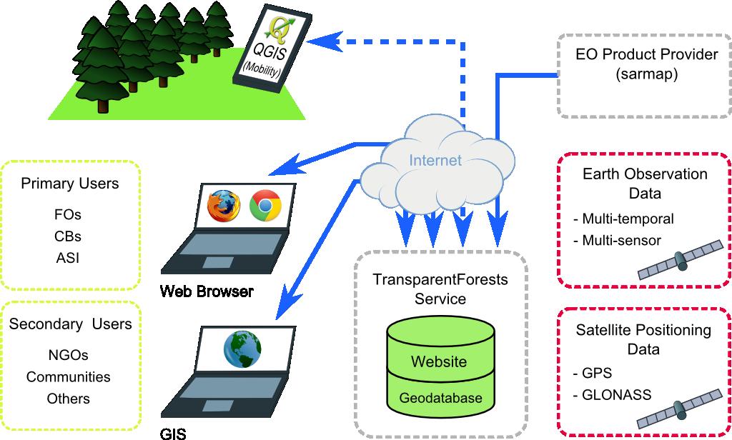
32 On-going and future actions The processing of large mul9- temporal mul9- sensor data implies: Suppor9ng the processing of all spaceborne SAR sensors and acquisi9on modes; Processing solu9ons on local cluster AND cloud compu9ng. Moving from CPU to GPU. The products are con9nuously developed in coopera9on with end users. Know- how transfer is on- going (as example refer to RIICE). A similar ini9a9ve is on- going with FSC (TransparentForests).


33 TransparentForests EO products
Francesco Holecz. TUBE II meeting - 17 June Land Degradation. Land Degradation
 Land Degradation Francesco Holecz Objective To identify and monitor land degraded areas, in particular those related to agricultural and pastoral activities. Following products are generated: Land cover
Review. Guoqing Sun Department of Geography, University of Maryland ABrief
 Review Guoqing Sun Department of Geography, University of Maryland gsun@glue.umd.edu ABrief Introduction Scattering Mechanisms and Radar Image Characteristics Data Availability Example of Applications
SARscape for ENVI. A Complete SAR Analysis Solution
 SARscape for ENVI A Complete SAR Analysis Solution IDL and ENVI A Foundation for SARscape IDL The Data Analysis & Visualization Platform Data Access: IDL supports virtually every data format, type and
SARscape Modules for ENVI
 Visual Information Solutions SARscape Modules for ENVI Read, process, analyze, and output products from SAR data. ENVI. Easy to Use Tools. Proven Functionality. Fast Results. DEM, based on TerraSAR-X-1
Fringe 2015 Workshop
 Fringe 2015 Workshop On the Estimation and Interpretation of Sentinel-1 TOPS InSAR Coherence Urs Wegmüller, Maurizio Santoro, Charles Werner and Oliver Cartus Gamma Remote Sensing AG - S1 IWS InSAR and
Earth Observation and Sensing Technologies: a focus on Radar Imaging Developments. Riccardo Lanari
 Earth Observation and Sensing Technologies: a focus on Radar Imaging Developments Riccardo Lanari Institute for Electromagnetic Sensing of the Environment (IREA) National Research Council of Italy (CNR)
SAR Imagery: Airborne or Spaceborne? Presenter: M. Lorraine Tighe PhD
 SAR Imagery: Airborne or Spaceborne? Presenter: M. Lorraine Tighe PhD Introduction The geospatial community has seen a plethora of spaceborne SAR imagery systems where there are now extensive archives
SARscape 4.1 Supported Sensors/Products (October 2008)
") SARscape 4.1 Supported Sensors/Products (October 2008) ALOS PALSAR (provided by JAXA) In case of RAW (level 1.0) data, import is carried out within the Focusing Module. PALSAR RAW data in CEOS standard
SARscape 4.1 Supported Sensors/Products (October 2008) ALOS PALSAR (provided by JAXA) In case of RAW (level 1.0) data, import is carried out within the Focusing Module. PALSAR RAW data in CEOS standard
Forest Discrimination Analysis of Combined Landsat and ALOS-PALSAR Data
 Forest Discrimination Analysis of Combined Landsat and ALOS-PALSAR Data E. Lehmann, P. Caccetta, Z.-S. Zhou, A. Held CSIRO, Division of Mathematics, Informatics and Statistics, Australia A. Mitchell, I.
COMBINED ANALYSIS OF OPTICAL AND SAR REMOTE SENSING DATA FOR FOREST MAPPING AND MONITORING
 7 th International Symposium on Digital Earth Perth, Australia 23-25 August 2011 COMBINED ANALYSIS OF OPTICAL AND SAR REMOTE SENSING DATA FOR FOREST MAPPING AND MONITORING E. LEHMANN 1, Z.-S. ZHOU 1, P.
European Space Agency and IPY
 European Space Agency and IPY ESA supports IPY 2007-2008 activities: First ESA step was a dedicated Announcement Opportunity (AO) for EO data provision in support IPY, released in 2006, with data provision
Damage detection in the 2015 Nepal earthquake using ALOS-2 satellite SAR imagery
 Proceedings of the Tenth Pacific Conference on Earthquake Engineering Building an Earthquake-Resilient Pacific 6-8 November 2015, Sydney, Australia Damage detection in the 2015 Nepal earthquake using ALOS-2
SAR Remote Sensing (Microwave Remote Sensing)
") iirs SAR Remote Sensing (Microwave Remote Sensing) Synthetic Aperture Radar Shashi Kumar shashi@iirs.gov.in Electromagnetic Radiation Electromagnetic radiation consists of an electrical field(e) which
iirs SAR Remote Sensing (Microwave Remote Sensing) Synthetic Aperture Radar Shashi Kumar shashi@iirs.gov.in Electromagnetic Radiation Electromagnetic radiation consists of an electrical field(e) which
Radar remote sensing from space for monitoring deformations affecting urban areas and infrastructures
 Radar remote sensing from space for monitoring deformations affecting urban areas and infrastructures Riccardo Lanari IREA-CNR Napoli EGU2014, Vienna 30 April, 2014 Why Radar (SAR) Imaging from space?
RADAR INTERFEROMETRY FOR SAFE COAL MINING IN CHINA
 RADAR INTERFEROMETRY FOR SAFE COAL MINING IN CHINA L. Ge a, H.-C. Chang a, A. H. Ng b and C. Rizos a Cooperative Research Centre for Spatial Information School of Surveying & Spatial Information Systems,
All rights reserved. ENVI, IDL and Jagwire are trademarks of Exelis, Inc. All other marks are the property of their respective owners.
 SAR Analysis Made Easy with SARscape 5.1 All rights reserved. ENVI, IDL and Jagwire are trademarks of Exelis, Inc. All other marks are the property of their respective owners. 2014, Exelis Visual Information
Contribution of Sentinel-1 data for the monitoring of seasonal variations of the vegetation
 Contribution of Sentinel-1 data for the monitoring of seasonal variations of the vegetation P.-L. Frison, S. Kmiha, B. Fruneau, K. Soudani, E. Dufrêne, T. Koleck, L. Villard, M. Lepage, J.-F. Dejoux, J.-P.
Comparison between SAR atmospheric phase screens at 30 by means of ERS and ENVISAT data
 Fringe 2007 - ESA-ESRIN - Frascati, November 28, 2007 Comparison between SAR atmospheric phase screens at 30 by means of ERS and ENVISAT data D. Perissin Politecnico di Milano Tele-Rilevamento Europa -
Introduction to radar. interferometry
 Introduction to radar Introduction to Radar Interferometry interferometry Presenter: F.Sarti (ESA/ESRIN) With kind contribution by the Radar Department of CNES All-weather observation system (active system)
Developing land cover products in Monsoon Asia through integration of Landsat (GLS2005) and L-band PALSAR imagery: --- An Update
 and L-band PALSAR imagery: --- An Update") Developing land cover products in Monsoon Asia through integration of Landsat (GLS2005) and L-band PALSAR imagery: --- An Update Landsat 7 ETM+ PALSAR Xiangming Xiao Center for Spatial Analysis, University
Developing land cover products in Monsoon Asia through integration of Landsat (GLS2005) and L-band PALSAR imagery: --- An Update Landsat 7 ETM+ PALSAR Xiangming Xiao Center for Spatial Analysis, University
Envisat and ERS missions: data and services
 FRINGE 2005 Workshop Envisat and ERS missions: and services Henri LAUR Envisat Mission Manager Our top objective: ease access to Earth Observation Common objective for all missions handled by ESA: Envisat,
Data acquisition and access for the Congo Basin
 MRV Joint Workshop 22-24 June 2010, Guadalajara, Jalisco Mexico Data acquisition and access for the Congo Basin Landing Mané 1, Michael Brady 2, Chris Justice 3 and Alice Altstatt 3 1) Satellite Observatory
Detecting and Mapping Invasive Phragmites australis in the Coastal Great Lakes with ALOS PALSAR Imagery
 Detecting and Mapping Invasive Phragmites australis in the Coastal Great Lakes with ALOS PALSAR Imagery Brian Huberty U.S Fish & Wildlife Service Region 3 Ecological Services Laura L. Bourgeau-Chavez,
TanDEM-X: Mission Status & Scientific Contribution
 TanDEM-X: Mission Status & Scientific Contribution Irena Hajnsek 1/2, Gerhard Krieger 1, Kostas Papathanassiou 1, Stefan Baumgartner 1, Marc Rodriguez-Cassola 1, Pau Prats 1, Maria Sanjuan Ferrer 1, Florian
NON-PHOTOGRAPHIC SYSTEMS: Multispectral Scanners Medium and coarse resolution sensor comparisons: Landsat, SPOT, AVHRR and MODIS
 NON-PHOTOGRAPHIC SYSTEMS: Multispectral Scanners Medium and coarse resolution sensor comparisons: Landsat, SPOT, AVHRR and MODIS CLASSIFICATION OF NONPHOTOGRAPHIC REMOTE SENSORS PASSIVE ACTIVE DIGITAL
PROGRESS IN ADDRESSING SCIENCE GOALS FOR GLACIER OBSERVATIONS BY MEANS OF SAR. Frank Paul & Thomas Nagler
 PROGRESS IN ADDRESSING SCIENCE GOALS FOR GLACIER OBSERVATIONS BY MEANS OF SAR Frank Paul & Thomas Nagler SAR Coordination Working Group Meeting, 13/11/2016 Observed glacier products and sensors Product
ASAR Training Course, Hanoi, 25 February 7 March 2008 Introduction to Radar Interferometry
 Introduction to Radar Interferometry Presenter: F.Sarti (ESA/ESRIN) 1 Imaging Radar : reminder 2 Physics of radar Potentialities of radar All-weather observation system (active system) Penetration capabilities
Introduction to Radar
 National Aeronautics and Space Administration ARSET Applied Remote Sensing Training http://arset.gsfc.nasa.gov @NASAARSET Introduction to Radar Jul. 16, 2016 www.nasa.gov Objective The objective of this
So S ft f w t a w re T o T ol Po P ls l A S Rpro v5.0. E. E. Po P ttie i r E.Pottier (2013)
") Software Tool PolSARprov5.0 E. Pottier The Polarimetric Polarimetric SAR Data Pro Processing cessing and Educational Tool v5.0 AIRSAR SETHI DCRS PISAR ESAR EMISAR UAV-SAR FSAR CONVAIR PolSARpro v5.0 Software
Software Tool PolSARprov5.0 E. Pottier The Polarimetric Polarimetric SAR Data Pro Processing cessing and Educational Tool v5.0 AIRSAR SETHI DCRS PISAR ESAR EMISAR UAV-SAR FSAR CONVAIR PolSARpro v5.0 Software
NORMALIZING ASTER DATA USING MODIS PRODUCTS FOR LAND COVER CLASSIFICATION
 NORMALIZING ASTER DATA USING MODIS PRODUCTS FOR LAND COVER CLASSIFICATION F. Gao a, b, *, J. G. Masek a a Biospheric Sciences Branch, NASA Goddard Space Flight Center, Greenbelt, MD 20771, USA b Earth
ACTIVE MICROWAVE REMOTE SENSING OF LAND SURFACE HYDROLOGY
 Basics, methods & applications ACTIVE MICROWAVE REMOTE SENSING OF LAND SURFACE HYDROLOGY Annett.Bartsch@polarresearch.at Active microwave remote sensing of land surface hydrology Landsurface hydrology:
9/12/2011. Training Course Remote Sensing Basic Theory & Image Processing Methods September 2011
 Training Course Remote Sensing Basic Theory & Image Processing Methods 19 23 September 2011 Popular Remote Sensing Sensors & their Selection Michiel Damen (September 2011) damen@itc.nl 1 Overview Low resolution
Forest Discrimination Analysis of Combined Landsat and ALOS-PALSAR Data
 Forest Discrimination Analysis of Combined Landsat and ALOS-PALSAR Data E. Lehmann 1, P. Caccetta 1, Z.-S. Zhou 1, A. Mitchell 2, I. Tapley 2, A. Milne 2, A. Held 3, K. Lowell 4, S. McNeill 5 1 CSIRO Mathematics,
School of Rural and Surveying Engineering National Technical University of Athens
 Laboratory of Photogrammetry National Technical University of Athens Combined use of spaceborne optical and SAR data Incompatible data sources or a useful procedure? Charalabos Ioannidis, Dimitra Vassilaki
RADAR REMOTE SENSING
 RADAR REMOTE SENSING Jan G.P.W. Clevers & Steven M. de Jong Chapter 8 of L&K 1 Wave theory for the EMS: Section 1.2 of L&K E = electrical field M = magnetic field c = speed of light : propagation direction
SAR Remote Sensing. Introduction into SAR. Data characteristics, challenges, and applications.
 SAR Remote Sensing Introduction into SAR. Data characteristics, challenges, and applications. PD Dr. habil. Christian Thiel, Friedrich-Schiller-University Jena DLR-HR Jena & Friedrich-Schiller-University
HIGH RESOLUTION DIFFERENTIAL INTERFEROMETRY USING TIME SERIES OF ERS AND ENVISAT SAR DATA
 HIGH RESOLUTION DIFFERENTIAL INTERFEROMETRY USING TIME SERIES OF ERS AND ENVISAT SAR DATA Javier Duro 1, Josep Closa 1, Erlinda Biescas 2, Michele Crosetto 2, Alain Arnaud 1 1 Altamira Information C/ Roger
SARscape s Coherent Changes Detection Tutorial
 SARscape s Coherent Changes Detection Tutorial Version 1.0 April 2018 1 Index Introduction... 3 Setting Preferences... 4 Data preparation... 5 Input data... 5 DEM Extraction... 5 Single Panels processing...
SAR missions for oceanography at the European Space Agency
 SAR missions for oceanography at the European Space Agency ERS-1, ERS-2, Envisat, Sentinel-1A, Sentinel-1B, ESA 3 rd Party Missions (ALOS) Prepared by ESA teams and ESA supporting companies ESA and SAR
Detecting and Mapping Invasive Phragmites australis in the coastal Great Lakes with ALOS PALSAR imagery
 Detecting and Mapping Invasive Phragmites australis in the coastal Great Lakes with ALOS PALSAR imagery Laura L. Bourgeau-Chavez, Kirk Scarbrough, Liza Jenkins, Kevin Riordan, Richard Powell, Colin Brooks,
Introduction of Satellite Remote Sensing
 Introduction of Satellite Remote Sensing Spatial Resolution (Pixel size) Spectral Resolution (Bands) Resolutions of Remote Sensing 1. Spatial (what area and how detailed) 2. Spectral (what colors bands)
REMOTE SENSING. Topic 10 Fundamentals of Digital Multispectral Remote Sensing MULTISPECTRAL SCANNERS MULTISPECTRAL SCANNERS
 REMOTE SENSING Topic 10 Fundamentals of Digital Multispectral Remote Sensing Chapter 5: Lillesand and Keifer Chapter 6: Avery and Berlin MULTISPECTRAL SCANNERS Record EMR in a number of discrete portions
Outline. From AGEA-JRC I (2007) to AGEA-JRC II ( ) COSMO-SkyMed constellation for Earth observation and applications
 to AGEA-JRC II ( ) COSMO-SkyMed constellation for Earth observation and applications") Outline From AGEA-JRC I (2007) to AGEA-JRC II (2008-09) COSMO-SkyMed constellation for Earth observation and applications COSMO-SkyMed GeoAccuracy assessment o Geometric o Parcels measurements performances
Outline From AGEA-JRC I (2007) to AGEA-JRC II (2008-09) COSMO-SkyMed constellation for Earth observation and applications COSMO-SkyMed GeoAccuracy assessment o Geometric o Parcels measurements performances
ACTIVE SENSORS RADAR
 ACTIVE SENSORS RADAR RADAR LiDAR: Light Detection And Ranging RADAR: RAdio Detection And Ranging SONAR: SOund Navigation And Ranging Used to image the ocean floor (produce bathymetic maps) and detect objects
PALSAR SCANSAR SCANSAR Interferometry
 PALSAR SCANSAR SCANSAR Interferometry Masanobu Shimada Japan Aerospace Exploration Agency Earth Observation Research Center ALOS PI symposium, Greece Nov. 6 2008 1 Introduction L-band PALSAR strip mode
Application and potentials of RADAR and LiDAR technologies for forest carbon assessment in Pacific Island Countries
 Application and potentials of RADAR and LiDAR technologies for forest carbon assessment in Pacific Island Countries June 19th, 2012 PNGFA-JICA Workshop Masamichi HARAGUCHI (Kokusai Kogyo Co., Ltd.) Consultant
TerraSAR-X Applications Guide
 TerraSAR-X Applications Guide Extract: Maritime Monitoring: Ship Detection April 2015 Airbus Defence and Space Geo-Intelligence Programme Line Maritime Monitoring: Ship Detection Issue Maritime security
SUGAR_GIS. From a user perspective. Provides spatial distribution of a wide range of sugarcane production data in an easy to use and sensitive way.
 SUGAR_GIS From a user perspective What is Sugar_GIS? A web-based, decision support tool. Provides spatial distribution of a wide range of sugarcane production data in an easy to use and sensitive way.
Specificities of Near Nadir Ka-band Interferometric SAR Imagery
 Specificities of Near Nadir Ka-band Interferometric SAR Imagery Roger Fjørtoft, Alain Mallet, Nadine Pourthie, Jean-Marc Gaudin, Christine Lion Centre National d Etudes Spatiales (CNES), France Fifamé
PROGRESS IN ADDRESSING SCIENCE GOALS FOR GLACIER OBSERVATIONS BY MEANS OF SAR
 PROGRESS IN ADDRESSING SCIENCE GOALS FOR GLACIER OBSERVATIONS BY MEANS OF SAR Frank Paul, Thomas Nagler, Dana Floricioiu, et al. PSTG, 13/9/2016 Panmah, Karakoram Observed glacier products and sensors
ASAR, MERIS and AATSR products
 ASAR, MERIS and AATSR products Francesco Sarti and Steffen Dransfeld ESA/ESRIN 25 February 2008 ENVISAT http://envisat.esa.int/ Launched in 2002. Sun-synchronous polar orbit (SSO): Nominal reference orbit
MODULE 9 LECTURE NOTES 2 ACTIVE MICROWAVE REMOTE SENSING
 MODULE 9 LECTURE NOTES 2 ACTIVE MICROWAVE REMOTE SENSING 1. Introduction Satellite sensors are capable of actively emitting microwaves towards the earth s surface. An active microwave system transmits
ANALYSIS OF SRTM HEIGHT MODELS
 ANALYSIS OF SRTM HEIGHT MODELS Sefercik, U. *, Jacobsen, K.** * Karaelmas University, Zonguldak, Turkey, ugsefercik@hotmail.com **Institute of Photogrammetry and GeoInformation, University of Hannover,
RADAR (RAdio Detection And Ranging)
") RADAR (RAdio Detection And Ranging) CLASSIFICATION OF NONPHOTOGRAPHIC REMOTE SENSORS PASSIVE ACTIVE DIGITAL CAMERA THERMAL (e.g. TIMS) VIDEO CAMERA MULTI- SPECTRAL SCANNERS VISIBLE & NIR MICROWAVE Real
RADAR (RAdio Detection And Ranging) CLASSIFICATION OF NONPHOTOGRAPHIC REMOTE SENSORS PASSIVE ACTIVE DIGITAL CAMERA THERMAL (e.g. TIMS) VIDEO CAMERA MULTI- SPECTRAL SCANNERS VISIBLE & NIR MICROWAVE Real
Satellite data processing and analysis: Examples and practical considerations
 Satellite data processing and analysis: Examples and practical considerations Dániel Kristóf Ottó Petrik, Róbert Pataki, András Kolesár International LCLUC Regional Science Meeting in Central Europe Sopron,
Estimation of soil moisture using radar and optical images over Grassland areas
 Estimation of soil moisture using radar and optical images over Grassland areas Mohamad El Hajj*, Nicolas Baghdadi*, Gilles Belaud, Mehrez Zribi, Bruno Cheviron, Dominique Courault, Olivier Hagolle, François
Synthetic Aperture Radar Interferometry (InSAR) Technique (Lecture I- Tuesday 11 May 2010)
 Technique (Lecture I- Tuesday 11 May 2010)") Synthetic Aperture Radar Interferometry () Technique (Lecture I- Tuesday 11 May 2010) ISNET/CRTEAN Training Course on Synthetic Aperture Radar (SAR) Imagery: Processing, Interpretation and Applications
Synthetic Aperture Radar Interferometry () Technique (Lecture I- Tuesday 11 May 2010) ISNET/CRTEAN Training Course on Synthetic Aperture Radar (SAR) Imagery: Processing, Interpretation and Applications
Introduction to KOMPSAT
 Introduction to KOMPSAT September, 2016 1 CONTENTS 01 Introduction of SIIS 02 KOMPSAT Constellation 03 New : KOMPSAT-3 50 cm 04 New : KOMPSAT-3A 2 KOMPSAT Constellation KOMPSAT series National space program
The TerraSAR-L System and Mission Objectives
 The TerraSAR-L System and Mission Objectives Manfred Zink & Ramon Torres TerraSAR Project, ESA-ESTEC Keplerlaan 1, 2200 AG, Noordwijk, The Netherlands Tel: +31 71565 3038, Fax: +31 71565 3191, Email: Manfred.Zink@esa.int
The Radar Ortho Suite is an add-on to Geomatica. It requires Geomatica Core or Geomatica Prime as a pre-requisite.
 Technical Specifications Radar Ortho Suite The Radar Ortho Suite includes rigorous and rational function models developed to compensate for distortions and produce orthorectified radar images. Distortions
High resolution ground deformations monitoring by COSMO-SkyMed PSP SAR interferometry
 High resolution ground deformations monitoring by COSMO-SkyMed PSP SAR interferometry Mario Costantini e-geos - an ASI/Telespazio Company, Rome, Italy mario.costantini@e-geos.it Summary COSMO-SkyMed satellite
WHAT IS NEXT IN EARTH OBSERVATION. SkyMed Mission
 WHAT IS NEXT IN EARTH OBSERVATION COSMO-SkyMed SkyMed Mission Paolo Ammendola Italian Space Agency Florence, Sept. 19, 2001 ammendola@asi asi.it THE NEEDS Market studies indicate that the value of the
SENTINEL-1 Toolbox. Polarimetric Tutorial Issued March 2015 Updated August Luis Veci
 SENTINEL-1 Toolbox Polarimetric Tutorial Issued March 2015 Updated August 2016 Luis Veci Copyright 2015 Array Systems Computing Inc. http://www.array.ca/ http://step.esa.int Polarimetric Tutorial The goal
Use of Synthetic Aperture Radar images for Crisis Response and Management
 2012 IEEE Global Humanitarian Technology Conference Use of Synthetic Aperture Radar images for Crisis Response and Management Gerardo Di Martino, Antonio Iodice, Daniele Riccio, Giuseppe Ruello Department
Remote sensing in archaeology from optical to lidar. Krištof Oštir ModeLTER Scientific Research Centre of the Slovenian Academy of Sciences and Arts
 Remote sensing in archaeology from optical to lidar Krištof Oštir ModeLTER Scientific Research Centre of the Slovenian Academy of Sciences and Arts Introduction Optical remote sensing Systems Search for
Time Trend Evaluations of Absolute Accuracies for PRISM and AVNIR-2
 The 3 rd ALOS Joint PI Symposium, Kona, Hawaii, US Nov. 9-13, 2009 Time Trend Evaluations of Absolute Accuracies for PRISM and AVNIR-2 Takeo Tadono*, Masanobu Shimada*, Hiroshi Murakami*, Junichi Takaku**,
TerraSAR-X Applications Guide
 TerraSAR-X Applications Guide Extract: Change Detection and Monitoring: Geospatial / Image Intelligence April 2015 Airbus Defence and Space Geo-Intelligence Programme Line Change Detection and Monitoring:
KOMPSAT Constellation. November 2012 Satrec Initiative
 KOMPSAT Constellation November 2012 Satrec Initiative KOMPSAT Constellation KOMPSAT National program Developed and operated by KARI (Korea Aerospace Research Institute) Dual use : Government & commercial
Change detection in cultural landscapes
 9-11 November 2015 ESA-ESRIN, Frascati (Rome), Italy 3 rd ESA-EARSeL Course on Remote Sensing for Archaeology Day 3 Change detection in cultural landscapes DeodatoTapete (1,2) & Francesca Cigna (1,2) (1)
Exploring the Potential Pol-InSAR Techniques at X-Band: First Results & Experiments from TanDEM-X
 Exploring the Potential Pol-InSAR Techniques at X-Band: First Results & Experiments from TanDEM-X K. Papathanassiou, F. Kugler, J-S. Kim, S-K. Lee, I. Hajnsek Microwaves and Radar Institute (DLR-HR) German
Monitoring of railroad infrastructure with the use of differential interferometric techniques of SAR data processing
 A.S.Vasileisky, R.I.Shuvalov Monitoring of railroad infrastructure with the use of differential interferometric techniques of SAR data processing From Imagery to Map Digital Photogrammetric Technologies
DEVELOPMENT OF A NEW SOUTH AFRICAN LAND-COVER DATASET USING AUTOMATED MAPPING TECHINQUES. Mark Thompson 1
 DEVELOPMENT OF A NEW SOUTH AFRICAN LAND-COVER DATASET USING AUTOMATED MAPPING TECHINQUES. Mark Thompson 1 1 GeoTerraImage Pty Ltd, Pretoria, South Africa Abstract This talk will discuss the development
TerraSAR-X and TanDEM-X: Revolution in Spaceborne Radar
 TerraSAR-X and TanDEM-X: Revolution in Spaceborne Radar Ralf Düring, Fifamè N. Koudogbo, and Marco Weber, Infoterra GmbH, 88039 Friedrichshafen, Germany INTRODUCTION While Earth Observation from space
The Current Status and Brief Results of Engineering Model for PALSAR-2 onboard ALOS-2 and Science Project
 The Current Status and Brief Results of Engineering Model for PALSAR-2 onboard ALOS-2 and Science Project + The 16 th KC meeting Japan Aerospace Exploration Agency Masanobu Shimada, Yukihiro KANKAKU The
COSMO-SkyMed Mission Status Presented by Fabrizio BATTAZZA (ASI)
") COSMO-SkyMed Mission Status Presented by Fabrizio BATTAZZA (ASI) COSMO-1 & COSMO-2 LAUNCHES FIRST SATELLITE OF THE CONSTELLATION SUCCESSFULLY LAUNCHED 08 June 2007 03:35 (GMT) Vandenberg U.S.A. Air Force
COSMO-SkyMed Mission Status Presented by Fabrizio BATTAZZA (ASI) COSMO-1 & COSMO-2 LAUNCHES FIRST SATELLITE OF THE CONSTELLATION SUCCESSFULLY LAUNCHED 08 June 2007 03:35 (GMT) Vandenberg U.S.A. Air Force
How accurately can current and futureinsar missions map tectonic strain?
 How accurately can current and futureinsar missions map tectonic strain? Outline: How accurately do we need to measure strain? InSAR missions Error budget for InSAR Ability of current, planned and proposed
TerraSAR-X Image Product Guide
 [Texte] TerraSAR-X Image Product Guide Page 1 of 24 Ref.: OP00xxxxxxxxxx Commercial in Confidence 1 Introduction TerraSAR-X and TanDEM-X are commercial German Synthetic Aperture Radar (SAR) Earth observation
Introduc)on*to*Asia/RiCE* Technical*Demonstra)on*Sites*II.** Japan,*Indonesia,*Vietnam*
on*to*Asia/RiCE* Technical*Demonstra)on*Sites*II.** Japan,*Indonesia,*Vietnam*") Introduc)on*to*Asia/RiCE* Technical*Demonstra)on*Sites*II.** Japan,*Indonesia,*Vietnam* Kei$Oyoshi 1,$Nobuhiro$Tomiyama 2,$Toshio$Okumura 2,$Shinichi$Sobue 1,2,$ Wahyu$Supriatna 3,$Rizatus$Shofiya? 3,$Lam$Dao$Nguyen
Introduc)on*to*Asia/RiCE* Technical*Demonstra)on*Sites*II.** Japan,*Indonesia,*Vietnam* Kei$Oyoshi 1,$Nobuhiro$Tomiyama 2,$Toshio$Okumura 2,$Shinichi$Sobue 1,2,$ Wahyu$Supriatna 3,$Rizatus$Shofiya? 3,$Lam$Dao$Nguyen
Landsat 8 and Sentinel 2 higher order products: input to S2DUP. Chris Justice (UMD) Curtis Woodcock (BU), Martin Claverie (UMD/GSFC)
 Curtis Woodcock (BU), Martin Claverie (UMD/GSFC)") Landsat 8 and Sentinel 2 higher order products: input to S2DUP Chris Justice (UMD) Curtis Woodcock (BU), Martin Claverie (UMD/GSFC) MODIS Land Products Energy Balance Product Suite Surface Reflectance
Landsat 8 and Sentinel 2 higher order products: input to S2DUP Chris Justice (UMD) Curtis Woodcock (BU), Martin Claverie (UMD/GSFC) MODIS Land Products Energy Balance Product Suite Surface Reflectance
RADARSAT-2 Modes and Applications
 RADARSAT-2 Modes and Applications Gordon Staples MDA Geospatial Services February 6, 2017 1 Introduction RADARSAT-2 was developed to meet operational needs via a versatile space segment and a responsive
UAVSAR in Africa. Quality Assurance and Preliminary Results. Brian Hawkins, UAVSAR Team
 Photo by Sassan Saatchi UAVSAR in Africa Quality Assurance and Preliminary Results Brian Hawkins, UAVSAR Team CEOS SAR Cal/Val Workshop 2016 Copyright 2016 California Institute of Technology. Government
Environmental and Natural Resources Issues in Minnesota. A Remote Sensing Overview: Principles and Fundamentals. Outline. Challenges.
 A Remote Sensing Overview: Principles and Fundamentals Marvin Bauer Remote Sensing and Geospatial Analysis Laboratory College of Natural Resources University of Minnesota Remote Sensing for GIS Users Workshop,
The TerraSAR-L Interferometric Mission Objectives
 The TerraSAR-L Interferometric Mission Objectives Manfred Zink TerraSAR Project, ESA-ESTEC Keplerlaan 1, 2200 AG, Noordwijk, The Netherlands Tel: +31 71565 3038, Fax: +31 71565 3191, Email: Manfred.Zink@esa.int
COMPARATIVE ANALYSIS OF INSAR DIGITAL SURFACE MODELS FOR TEST AREA BUCHAREST
 COMPARATIVE ANALYSIS OF INSAR DIGITAL SURFACE MODELS FOR TEST AREA BUCHAREST Iulia Dana (1), Valentin Poncos (2), Delia Teleaga (2) (1) Romanian Space Agency, 21-25 Mendeleev Street, 010362, Bucharest,
CURRENT SCENARIO AND CHALLENGES IN THE ANALYSIS OF MULTITEMPORAL REMOTE SENSING IMAGES
 Remote Sensing Laboratory Dept. of Information Engineering and Computer Science University of Trento Via Sommarive, 14, I-38123 Povo, Trento, Italy CURRENT SCENARIO AND CHALLENGES IN THE ANALYSIS OF MULTITEMPORAL
RADARSAT-2 Program Update Daniel De Lisle Canadian Space Agency
 RADARSAT-2 Program Update Daniel De Lisle Canadian Space Agency Presentation outline RADARSAT-1 Update RADARSAT-2 Mission description Mission Objectives System Characteristics Data Commercialization/Allocation
Satellite Remote Sensing: Earth System Observations
 Satellite Remote Sensing: Earth System Observations Land surface Water Atmosphere Climate Ecosystems 1 EOS (Earth Observing System) Develop an understanding of the total Earth system, and the effects of
remote sensing? What are the remote sensing principles behind these Definition
 Introduction to remote sensing: Content (1/2) Definition: photogrammetry and remote sensing (PRS) Radiation sources: solar radiation (passive optical RS) earth emission (passive microwave or thermal infrared
Canadian Space Agency Contribution to STG
 Canadian Space Agency Contribution to STG Canadian Space Agency 1 STG5 Geneva, Nov 30 to Dec 2, 2009 2 Canadian Space Agency ASAP Portefolio: Name Frozen Baseline Sea Ice Min and Max Snapshots Fine Image
SAOCOM-CS Mission and ESA Airborne Campaign Data
 SAOCOM-CS Mission and ESA Airborne Campaign Data Malcolm Davidson Head of the EOP Campaign Section Malcolm.Davidson@esa.int Objectives of presentation Introduce a new type of ESA SAR mission with Polarimetrice,
The studies began when the Tiros satellites (1960) provided man s first synoptic view of the Earth s weather systems.
 provided man s first synoptic view of the Earth s weather systems.") Remote sensing of the Earth from orbital altitudes was recognized in the mid-1960 s as a potential technique for obtaining information important for the effective use and conservation of natural resources.
Remote sensing of the Earth from orbital altitudes was recognized in the mid-1960 s as a potential technique for obtaining information important for the effective use and conservation of natural resources.
ALOS-2 followon shimada-masanobu
 ALOS-2 followon-2020 shimada-masanobu 25m resolution global mosaic using PALSAR-2 FBD data Old ver. of 2015 Mosaic (Africa) Stripes in the old version of mosaic 2015 PALSAR-2 25m Global Mosaic New ver.
Activity Data (AD) Monitoring in the frame of REDD+ MRV
 Monitoring in the frame of REDD+ MRV") Activity Data (AD) Monitoring in the frame of REDD+ MRV Preliminary comments REDD+ is sustainable low emissions, high carbon rural development Monitoring efforts should support this effort Challenges Diversity
Activity Data (AD) Monitoring in the frame of REDD+ MRV Preliminary comments REDD+ is sustainable low emissions, high carbon rural development Monitoring efforts should support this effort Challenges Diversity
RESERVOIR MONITORING USING RADAR SATELLITES
 RESERVOIR MONITORING USING RADAR SATELLITES Alain Arnaud, Johanna Granda, Geraint Cooksley ALTAMIRA INFORMATION S.L., Calle Córcega 381-387, E-08037 Barcelona, Spain. Key words: Reservoir monitoring, InSAR,
Application Potential of Planned SAR Satellites a Preview
 PREPRINT/PRÉTIRAGE Application Potential of Planned SAR Satellites a Preview J.J. van der Sanden 1, P. Budkewitsch 1, R. Landry 1, M.J. Manore 2, H. McNairn 1, T.J. Pultz 1, and P.W. Vachon 1 1 Canada
ASAR acquisition strategy for IPY -Update-
 ASAR acquisition strategy for IPY -Update- Jorge Del Rio Vera Henri Laur Presentation contents: 1. Background 2. ASAR Acquisition strategy update Tandem Campaign ICESat support campaign Wilkins Iceshelf
SAR Multi-Temporal Applications
 SAR Multi-Temporal Applications 83230359-DOC-TAS-EN-001 Contents 2 Advantages of SAR Remote Sensing Technology All weather any time Frequencies and polarisations Interferometry and 3D mapping Change Detection
Monitoring of Bridge Deformation with InSAR: An Experimental Study
 XXIV FIG International Congress 2010 11-16 April 2010 Sydney, Australia Monitoring of Bridge Deformation with InSAR: An Experimental Study Lei Zhang 1, Xiaoli Ding 1 and Zhong Lu 2 1 Department of Land
XSAT Ground Segment at CRISP
 XSAT Ground Segment at CRISP LIEW Soo Chin Head of Research, CRISP http://www.crisp.nus.edu.sg 5 th JPTM for Sentinel Asia Step-2, 14-16 Nov 2012, Daejeon, Korea Centre for Remote Imaging, Sensing and
PROGRESS IN ICESHEET MONITORING USING SENTINEL SATELLITES
 Polar Space Task Group PROGRESS IN ICESHEET MONITORING USING SENTINEL SATELLITES Thomas Nagler, Helmut Rott, Markus Hetzenecker, Jan Wuite / ENVEO Contributions by Dana Floricioiu / DLR Anders Kusk / DTU