Radar remote sensing from space for monitoring deformations affecting urban areas and infrastructures
|
|
|
- Darleen Griffin
- 5 years ago
- Views:
Transcription


1 Radar remote sensing from space for monitoring deformations affecting urban areas and infrastructures Riccardo Lanari IREA-CNR Napoli EGU2014, Vienna 30 April, 2014
2 Why Radar (SAR) Imaging from space? Active sensors: capability to "observe" during day and night Microwave sensors: capability to "observe" even in presence of clouds Coherent sensors: capability to preserve both amplitude and phase information (SAR Interferometry)


3 Observing with coherent systems -> DInSAR Scenario 3/2000-7/2000 S(t1) Interferogram Baseline Campi Flegrei S(t2) - λ/2 -


4 DInSAR Scenario (3) The 29 May 2012, 5.8 M L Emilia (North Italy) earthquake

5 Temporal evolution of radar satellites for Earth Observation First Generation ERS1 J-ERS1 ERS2 RADARSAT-1 RADARSAT-2 ENVISAT ALOS COSMO-SKYMED TERRASAR-X SENTINEL-1 Second generation ALOS-2
 ERS/ENVISAT images (1992 2010) ERS")


6 Advanced DInSAR technique: the Small BAseline Subset (SBAS) ERS/ENVISAT images ( ) ERS ENVISAT Interferograms Ischia Campi Flegrei Mt. Vesuvio Mean deformation velocity [cm/yr] < > 0.75 Berardino et al., 2002, IEEE Trans. Geosci. Remote Sens. Pepe et al., 2005, IEEE Trans. Geosci. Remote Sens.


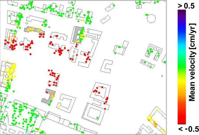
7 Urban deformation phenomena: the city of Rome > 0.5 Mean velocity [cm/yr] <- 0.5 Viale Giustiniano Imperatore area Zeni et al., 2011, J. Geophys. Eng. ERS/ENVISAT images ( )


8 Selected buildings for damage assessment Bld. 2 Building 1 Bld. 1 Building 2


9 DInSAR analysis on Viale Giustiniano Imperatore area P1 P2 P3 Zeni et al., 2011, J. Geophys. Eng.

")

10 Locone Lake Dam (Puglia, South Italy) ERS/ENVISAT images ( ) Bonano et al., 2012, Int. J. Remote Sens.


11 Invasi artificiali per centrale idroelettrica Analisi SqueeSAR
12 COSMO-SkyMed (CSK) Constellation CSK3 CSK1 CSK2 CSK4 CSK1 8 days 1 3 days 4 days Time 16 days Sensor spatial resolution: 3 m Spatial coverage: 40 x 40 km X-band

13 SAR sensors : from the first to the second generation ERS: C-Band Spatial resolution: 5x20 m Revisit time: 35 days Archives: Cosmo-SkyMED: X-Band Spatial resolution: 3x3 m Revisit time: 8 days Archives: today
. A radar scanner that can be used to analyze the vertical profile of the scattering (urban area, forest) is therefore implemented.")
14 SAR Tomography: 3D imaging By synthesizing an antenna also in the slant height direction orthogonal to the line of sight it is possible to extend the classical 2D (azimuth-slant range) SAR imaging to 3D (azimuth-slant range-slant height). A radar scanner that can be used to analyze the vertical profile of the scattering (urban area, forest) is therefore implemented. International awards: IEEE Gesocience and Remote Sensing Letters Award 2011 Student Competition prize alla Conferenza IEEE-GRS/ISPRS JURSE 2011, Muenchen, Germania Student Competition prize alla Conferenza IEEE-GRS/ISPRS JURSE 2013, Sao Paulo, Brasile
: SAR")
15 3D reconstruction of the San Paolo Stadium (Napoli, South Italy): SAR tomography

16 Differential SAR Tomography: 4D imaging SAR tomography allows also monitoring displacements over the time of the reconstructed 3D point clouds. 4D imaging has been shown to overcome the performances of classical deformation monitoring methods based only on the use of the phase information, not only for what concerns the solution of the layover but also for the detection of scatterers in the absence of layover. Example of monitoring of deformation of infrastructures with the 4D Imaging technique on COSMO-Skymed data: 30 images acquired between

17 Thanks!
18
Earth Observation and Sensing Technologies: a focus on Radar Imaging Developments. Riccardo Lanari
 Earth Observation and Sensing Technologies: a focus on Radar Imaging Developments Riccardo Lanari Institute for Electromagnetic Sensing of the Environment (IREA) National Research Council of Italy (CNR)
High resolution ground deformations monitoring by COSMO-SkyMed PSP SAR interferometry
 High resolution ground deformations monitoring by COSMO-SkyMed PSP SAR interferometry Mario Costantini e-geos - an ASI/Telespazio Company, Rome, Italy mario.costantini@e-geos.it Summary COSMO-SkyMed satellite
Synthetic Aperture Radar for Rapid Flood Extent Mapping
 National Aeronautics and Space Administration ARSET Applied Remote Sensing Training http://arset.gsfc.nasa.gov @NASAARSET Synthetic Aperture Radar for Rapid Flood Extent Mapping Sang-Ho Yun ARIA Team Jet
Use of Synthetic Aperture Radar images for Crisis Response and Management
 2012 IEEE Global Humanitarian Technology Conference Use of Synthetic Aperture Radar images for Crisis Response and Management Gerardo Di Martino, Antonio Iodice, Daniele Riccio, Giuseppe Ruello Department
SARscape Modules for ENVI
 Visual Information Solutions SARscape Modules for ENVI Read, process, analyze, and output products from SAR data. ENVI. Easy to Use Tools. Proven Functionality. Fast Results. DEM, based on TerraSAR-X-1
IMPACT OF BAQ LEVEL ON INSAR PERFORMANCE OF RADARSAT-2 EXTENDED SWATH BEAM MODES
 IMPACT OF BAQ LEVEL ON INSAR PERFORMANCE OF RADARSAT-2 EXTENDED SWATH BEAM MODES Jayson Eppler (1), Mike Kubanski (1) (1) MDA Systems Ltd., 13800 Commerce Parkway, Richmond, British Columbia, Canada, V6V
Warren Cartwright, Product Manager MDA Geospatial Services, Canada
 Advanced InSAR Techniques for Urban Infrastructure Monitoring Warren Cartwright, Product Manager MDA Geospatial Services, Canada www.mdacorporation.com RESTRICTION ON USE, PUBLICATION OR DISCLOSURE OF
Change detection in cultural landscapes
 9-11 November 2015 ESA-ESRIN, Frascati (Rome), Italy 3 rd ESA-EARSeL Course on Remote Sensing for Archaeology Day 3 Change detection in cultural landscapes DeodatoTapete (1,2) & Francesca Cigna (1,2) (1)
Environmental Impact Assessment of Mining Subsidence by Using Spaceborne Radar Interferometry
 Environmental Impact Assessment of Mining Subsidence by Using Spaceborne Radar Interferometry Hsing-Chung CHANG, Linlin GE and Chris RIZOS, Australia Key words: Mining Subsidence, InSAR, DInSAR, DEM. SUMMARY
HIGH RESOLUTION DIFFERENTIAL INTERFEROMETRY USING TIME SERIES OF ERS AND ENVISAT SAR DATA
 HIGH RESOLUTION DIFFERENTIAL INTERFEROMETRY USING TIME SERIES OF ERS AND ENVISAT SAR DATA Javier Duro 1, Josep Closa 1, Erlinda Biescas 2, Michele Crosetto 2, Alain Arnaud 1 1 Altamira Information C/ Roger
EE 529 Remote Sensing Techniques. Introduction
 EE 529 Remote Sensing Techniques Introduction Course Contents Radar Imaging Sensors Imaging Sensors Imaging Algorithms Imaging Algorithms Course Contents (Cont( Cont d) Simulated Raw Data y r Processing
Urban tunneling and the advantages of using InSAR SPN satellite technology to detect and monitor surface deformation effects
 Urban tunneling and the advantages of using InSAR SPN satellite technology to detect and monitor surface deformation effects María de Faragó 1, Geraint Cooksley 1 1 Altamira Information, Spain ABSTRACT
Figure 1: C band and L band (SIR-C/X-SAR images of Flevoland in Holland). color scheme: HH: red, HV:green, VV: blue
. color scheme: HH: red, HV:green, VV: blue") L-band PS analysis: JERS-1 results and TerraSAR L predictions Kenji Daito (1), Alessandro Ferretti (), Shigeki Kuzuoka (3),Fabrizio Novali (), Pietro Panzeri (), Fabio Rocca (4) (1) Daido Institute of
L-band PS analysis: JERS-1 results and TerraSAR L predictions Kenji Daito (1), Alessandro Ferretti (), Shigeki Kuzuoka (3),Fabrizio Novali (), Pietro Panzeri (), Fabio Rocca (4) (1) Daido Institute of
All rights reserved. ENVI, IDL and Jagwire are trademarks of Exelis, Inc. All other marks are the property of their respective owners.
 SAR Analysis Made Easy with SARscape 5.1 All rights reserved. ENVI, IDL and Jagwire are trademarks of Exelis, Inc. All other marks are the property of their respective owners. 2014, Exelis Visual Information
Fringe 2015 Workshop
 Fringe 2015 Workshop On the Estimation and Interpretation of Sentinel-1 TOPS InSAR Coherence Urs Wegmüller, Maurizio Santoro, Charles Werner and Oliver Cartus Gamma Remote Sensing AG - S1 IWS InSAR and
Francesco Holecz. TUBE II meeting - 17 June Land Degradation. Land Degradation
 Land Degradation Francesco Holecz Objective To identify and monitor land degraded areas, in particular those related to agricultural and pastoral activities. Following products are generated: Land cover
RADAR INTERFEROMETRY FOR SAFE COAL MINING IN CHINA
 RADAR INTERFEROMETRY FOR SAFE COAL MINING IN CHINA L. Ge a, H.-C. Chang a, A. H. Ng b and C. Rizos a Cooperative Research Centre for Spatial Information School of Surveying & Spatial Information Systems,
School of Rural and Surveying Engineering National Technical University of Athens
 Laboratory of Photogrammetry National Technical University of Athens Combined use of spaceborne optical and SAR data Incompatible data sources or a useful procedure? Charalabos Ioannidis, Dimitra Vassilaki
PSInSAR VALIDATION BY MEANS OF A BLIND EXPERIMENT USING DIHEDRAL REFLECTORS
 PSInSAR VALIDATION BY MEANS OF A BLIND EXPERIMENT USING DIHEDRAL REFLECTORS G. Savio (1), A. Ferretti (1) (2), F. Novali (1), S. Musazzi (3), C. Prati (2), F. Rocca (2) (1) Tele-Rilevamento Europa T.R.E.
MULTI-CHANNEL SAR EXPERIMENTS FROM THE SPACE AND FROM GROUND: POTENTIAL EVOLUTION OF PRESENT GENERATION SPACEBORNE SAR
 3 nd International Workshop on Science and Applications of SAR Polarimetry and Polarimetric Interferometry POLinSAR 2007 January 25, 2007 ESA/ESRIN Frascati, Italy MULTI-CHANNEL SAR EXPERIMENTS FROM THE
Microwave remote sensing. Rudi Gens Alaska Satellite Facility Remote Sensing Support Center
 Microwave remote sensing Alaska Satellite Facility Remote Sensing Support Center 1 Remote Sensing Fundamental The entire range of EM radiation constitute the EM Spectrum SAR sensors sense electromagnetic
SAR Remote Sensing (Microwave Remote Sensing)
") iirs SAR Remote Sensing (Microwave Remote Sensing) Synthetic Aperture Radar Shashi Kumar shashi@iirs.gov.in Electromagnetic Radiation Electromagnetic radiation consists of an electrical field(e) which
iirs SAR Remote Sensing (Microwave Remote Sensing) Synthetic Aperture Radar Shashi Kumar shashi@iirs.gov.in Electromagnetic Radiation Electromagnetic radiation consists of an electrical field(e) which
EVALUATING THE EFFECT OF THE OBSERVATION TIME ON THE DISTRIBUTION OF SAR PERMANENT SCATTERERS
 EVALUATING THE EFFECT OF THE OBSERVATION TIME ON THE DISTRIBUTION OF SAR PERMANENT SCATTERERS Alessandro Ferretti (), Carlo Colesanti (), Daniele Perissin (), Claudio Prati (), and Fabio Rocca () () Tele-Rilevamento
Multiscale Monitoring and Health Assessment for Effective Management of Flood-Control Infrastructure Systems
 Multiscale Monitoring and Health Assessment for Effective Management of Flood-Control Infrastructure Systems Tarek Abdoun Rensselaer Polytechnic Institute Levees Everywhere 3 Vision SAR Satellite 4 SAR
SARscape for ENVI. A Complete SAR Analysis Solution
 SARscape for ENVI A Complete SAR Analysis Solution IDL and ENVI A Foundation for SARscape IDL The Data Analysis & Visualization Platform Data Access: IDL supports virtually every data format, type and
Specificities of Near Nadir Ka-band Interferometric SAR Imagery
 Specificities of Near Nadir Ka-band Interferometric SAR Imagery Roger Fjørtoft, Alain Mallet, Nadine Pourthie, Jean-Marc Gaudin, Christine Lion Centre National d Etudes Spatiales (CNES), France Fifamé
Detection of a Point Target Movement with SAR Interferometry
 Journal of the Korean Society of Remote Sensing, Vol.16, No.4, 2000, pp.355~365 Detection of a Point Target Movement with SAR Interferometry Jung-Hee Jun* and Min-Ho Ka** Agency for Defence Development*,
Deformation Monitoring with Terrestrial SAR Interferometry
 Lisbon, 12 October 2009 Deformation Monitoring with Terrestrial SAR Interferometry Michele Crosetto Institute of Geomatics Castelldefels (Barcelona) michele.crosetto@ideg.es 1 Content Introduction: Satellite-based
Earth Observation from a Moon based SAR: Potentials and Limitations
 Earth Observation from a Moon based SAR: Potentials and Limitations F. Bovenga 1, M. Calamia 2,3, G. Fornaro 5, G. Franceschetti 4, L. Guerriero 1, F. Lombardini 5, A. Mori 2 1 Politecnico di Bari - Dipartimento
Sentinel-1 System Overview
 Sentinel-1 System Overview Dirk Geudtner, Rámon Torres, Paul Snoeij, Malcolm Davidson European Space Agency, ESTEC Global Monitoring for Environment and Security (GMES) EU-led program aiming at providing
Nazemeh Ashrafianfar, Hans-Peter Hebel and Wolfgang Busch
 MONITORING OF MINING INDUCED LAND SUBSIDENCE - DIFFERENTIAL SAR INTERFEROMETRY AND PERSISTENT SCATTERER INTERFEROMETRY USING TERRASAR-X DATA IN COMPARISON WITH ENVISAT DATA ABSTRACT Nazemeh Ashrafianfar,
GFOI Expert Workshop. Sensor interoperability, complementarity, and the temporal component. Francesco Holecz
 GFOI Expert Workshop Sensor interoperability, complementarity, and the temporal component Francesco Holecz Woods Hole Research Centre, MA, USA 10-11 June, 2014 On sensor interoperability Single-date vs.
SAR Imagery: Airborne or Spaceborne? Presenter: M. Lorraine Tighe PhD
 SAR Imagery: Airborne or Spaceborne? Presenter: M. Lorraine Tighe PhD Introduction The geospatial community has seen a plethora of spaceborne SAR imagery systems where there are now extensive archives
TerraSAR-X Applications Guide
 TerraSAR-X Applications Guide Extract: Change Detection and Monitoring: Geospatial / Image Intelligence April 2015 Airbus Defence and Space Geo-Intelligence Programme Line Change Detection and Monitoring:
URBAN MONITORING USING PERSISTENT SCATTERER INSAR AND PHOTOGRAMMETRY
 URBAN MONITORING USING PERSISTENT SCATTERER INSAR AND PHOTOGRAMMETRY Junghum Yu *, Alex Hay-Man Ng, Sungheuk Jung, Linlin Ge, and Chris Rizos. School of Surveying and Spatial Information Systems, University
COMPARATIVE ANALYSIS OF INSAR DIGITAL SURFACE MODELS FOR TEST AREA BUCHAREST
 COMPARATIVE ANALYSIS OF INSAR DIGITAL SURFACE MODELS FOR TEST AREA BUCHAREST Iulia Dana (1), Valentin Poncos (2), Delia Teleaga (2) (1) Romanian Space Agency, 21-25 Mendeleev Street, 010362, Bucharest,
SAR Multi-Temporal Applications
 SAR Multi-Temporal Applications 83230359-DOC-TAS-EN-001 Contents 2 Advantages of SAR Remote Sensing Technology All weather any time Frequencies and polarisations Interferometry and 3D mapping Change Detection
Monitoring of railroad infrastructure with the use of differential interferometric techniques of SAR data processing
 A.S.Vasileisky, R.I.Shuvalov Monitoring of railroad infrastructure with the use of differential interferometric techniques of SAR data processing From Imagery to Map Digital Photogrammetric Technologies
GNSS-Reflectometry for Observation and Monitoring of Earth surface
 GNSS-Reflectometry for Observation and Monitoring of Earth surface Global Navigation meets Geoinformation ESA ESOC Darmstadt, 28-04-2017 Dr. Ing. Domenico Schiavulli INR engineer support at EUMETSAT Outline
KONGSBERG SATELLITE SERVICES Earth Observation for Maritime Operations Current Capabilities and Future Potential
 KONGSBERG SATELLITE SERVICES 2017 Earth Observation for Maritime Operations Current Capabilities and Future Potential Andreas Hay Kaljord Project Manager KSAT HQ IN TROMSØ - 69N WELCOME TO TROMSØ Established
Playa del Rey, California InSAR Ground Deformation Monitoring Interim Report H
 Playa del Rey, California InSAR Ground Deformation Monitoring Interim Report H Ref.: RV-14524 Doc.: CM-168-01 January 31, 2013 SUBMITTED TO: Southern California Gas Company 555 W. Fifth Street (Mail Location
TanDEM-X: Mission Status & Scientific Contribution
 TanDEM-X: Mission Status & Scientific Contribution Irena Hajnsek 1/2, Gerhard Krieger 1, Kostas Papathanassiou 1, Stefan Baumgartner 1, Marc Rodriguez-Cassola 1, Pau Prats 1, Maria Sanjuan Ferrer 1, Florian
RADAR REMOTE SENSING
 RADAR REMOTE SENSING Jan G.P.W. Clevers & Steven M. de Jong Chapter 8 of L&K 1 Wave theory for the EMS: Section 1.2 of L&K E = electrical field M = magnetic field c = speed of light : propagation direction
TerraSAR-X Applications Guide
 TerraSAR-X Applications Guide Extract: Maritime Monitoring: Ship Detection April 2015 Airbus Defence and Space Geo-Intelligence Programme Line Maritime Monitoring: Ship Detection Issue Maritime security
RESERVOIR MONITORING USING RADAR SATELLITES
 RESERVOIR MONITORING USING RADAR SATELLITES Alain Arnaud, Johanna Granda, Geraint Cooksley ALTAMIRA INFORMATION S.L., Calle Córcega 381-387, E-08037 Barcelona, Spain. Key words: Reservoir monitoring, InSAR,
EKATERINA TYMOFYEYEVA GMTSAR BATCH PROCESSING
 EKATERINA TYMOFYEYEVA GMTSAR BATCH PROCESSING THANK YOU! Xiaopeng Tong Xiaohua (Eric) Xu David Sandwell Yuri Fialko OUTLINE Batch processing scripts in GMTSAR (focus on Sentinel-1) SBAS: a method for calculating
Acknowledgment. Process of Atmospheric Radiation. Atmospheric Transmittance. Microwaves used by Radar GMAT Principles of Remote Sensing
 GMAT 9600 Principles of Remote Sensing Week 4 Radar Background & Surface Interactions Acknowledgment Mike Chang Natural Resources Canada Process of Atmospheric Radiation Dr. Linlin Ge and Prof Bruce Forster
Dynamics and Control Issues for Future Multistatic Spaceborne Radars
 Dynamics and Control Issues for Future Multistatic Spaceborne Radars Dr Stephen Hobbs Space Research Centre, School of Engineering, Cranfield University, UK Abstract Concepts for future spaceborne radar
Study of Low Cost InSAR for SAGD Steam Chamber Monitoring
 Study of Low Cost InSAR for SAGD Steam Chamber Monitoring LOOKNorth Report R-15-033-6055 Prepared for: Revision 2.1 2015-07-07 Captain Robert A. Bartlett Building Morrissey Road St. John s, NL Canada A1B
Synthetic Aperture Radar Interferometry (InSAR) Technique (Lecture I- Tuesday 11 May 2010)
 Technique (Lecture I- Tuesday 11 May 2010)") Synthetic Aperture Radar Interferometry () Technique (Lecture I- Tuesday 11 May 2010) ISNET/CRTEAN Training Course on Synthetic Aperture Radar (SAR) Imagery: Processing, Interpretation and Applications
Synthetic Aperture Radar Interferometry () Technique (Lecture I- Tuesday 11 May 2010) ISNET/CRTEAN Training Course on Synthetic Aperture Radar (SAR) Imagery: Processing, Interpretation and Applications
Biomass, a polarimetric interferometric P-band SAR mission
 Biomass, a polarimetric interferometric P-band SAR mission M. Arcioni, P. Bensi, M. Fehringer, F. Fois, F. Heliere, N. Miranda, K. Scipal Fringe 2015, ESRIN 27/03/2015 The Biomass Mission 1. Biomass was
Comparison between SAR atmospheric phase screens at 30 by means of ERS and ENVISAT data
 Fringe 2007 - ESA-ESRIN - Frascati, November 28, 2007 Comparison between SAR atmospheric phase screens at 30 by means of ERS and ENVISAT data D. Perissin Politecnico di Milano Tele-Rilevamento Europa -
Terrain Motion and Persistent Scatterer InSAR
 Terrain Motion and Persistent Scatterer InSAR Andy Hooper University of Leeds ESA Land Training Course, Gödöllő, Hungary, 4-9 th September, 2017 Good Interferogram 2011 Tohoku earthquake Good correlation
SAR Remote Sensing. Introduction into SAR. Data characteristics, challenges, and applications.
 SAR Remote Sensing Introduction into SAR. Data characteristics, challenges, and applications. PD Dr. habil. Christian Thiel, Friedrich-Schiller-University Jena DLR-HR Jena & Friedrich-Schiller-University
WIDE-SWATH imaging and high azimuth resolution pose
 260 IEEE GEOSCIENCE AND REMOTE SENSING LETTERS, VOL 1, NO 4, OCTOBER 2004 Unambiguous SAR Signal Reconstruction From Nonuniform Displaced Phase Center Sampling Gerhard Krieger, Member, IEEE, Nicolas Gebert,
 Performance Comparison between Dual Polarimetric and Fully Polarimetric data for DInSAR Subsidence monitoring Dani Monells, Jordi J. Mallorquí Universitat Politècnica de Catalunya, Departament de Teoria
How accurately can current and futureinsar missions map tectonic strain?
 How accurately can current and futureinsar missions map tectonic strain? Outline: How accurately do we need to measure strain? InSAR missions Error budget for InSAR Ability of current, planned and proposed
WHAT IS NEXT IN EARTH OBSERVATION. SkyMed Mission
 WHAT IS NEXT IN EARTH OBSERVATION COSMO-SkyMed SkyMed Mission Paolo Ammendola Italian Space Agency Florence, Sept. 19, 2001 ammendola@asi asi.it THE NEEDS Market studies indicate that the value of the
Persistent Scatterer InSAR
 Persistent Scatterer InSAR Andy Hooper University of Leeds Synthetic Aperture Radar: A Global Solution for Monitoring Geological Disasters, ICTP, 2 Sep 2013 Good Interferogram 2011 Tohoku earthquake Good
Client: Statens vegvesen, Region midt County: Sør Trondelag
 Geological Survey of Norway N-7441 Trondheim, Norway REPORT Report no.: 2004.043 ISSN 0800-3416 Grading: Open Title: Preliminary analysis of InSAR data over Trondheim with respect to future road development
DISPLACEMENT AND DEFORMATION MEASUREMENT USING GROUND RADAR INTERFEROMETRY TECHNIQUE
 JOURNAL OF APPLIED ENGINEERING SCIENCES Article Number: 124_VOL. 1(16), issue 1_2013, pp.111-118 ISSN 2247-3769 ISSN-L 2247-3769 (Print) / e-issn:2284-7197 DISPLACEMENT AND DEFORMATION MEASUREMENT USING
A Combined Multi-Temporal InSAR Method: Incorporating Persistent Scatterer and Small Baseline Approaches. Andy Hooper University of Iceland
 A Combined Multi-Temporal InSAR Method: Incorporating Persistent Scatterer and Small Baseline Approaches Andy Hooper University of Iceland Time Multi-Temporal InSAR Same area imaged each time Multi-Temporal
Sentinel-1 Overview. Dr. Andrea Minchella
 Dr. Andrea Minchella 21-22/01/2016 ESA SNAP-Sentinel-1 Training Course Satellite Applications Catapult - Electron Building, Harwell, Oxfordshire Contents Sentinel-1 Mission Sentinel-1 SAR Modes Sentinel-1
Mine Subsidence Monitoring Using Multi-source Satellite SAR Images
 Mine Subsidence Monitoring Using Multi-source Satellite SAR Images Linlin Ge, Hsing-Chung Chang and Chris Rizos Cooperative Research Centre for Spatial Information & School of Surveying and Spatial Information
Analysis and interpretation of tsunami damage caused by the 2011 Japan earthquake using ENVISAT ASAR images
 IOP Conference Series: Earth and Environmental Science OPEN ACCESS Analysis and interpretation of tsunami damage caused by the 2011 Japan earthquake using ENVISAT ASAR images To cite this article: Yanmei
ACTIVE MICROWAVE REMOTE SENSING OF LAND SURFACE HYDROLOGY
 Basics, methods & applications ACTIVE MICROWAVE REMOTE SENSING OF LAND SURFACE HYDROLOGY Annett.Bartsch@polarresearch.at Active microwave remote sensing of land surface hydrology Landsurface hydrology:
Currents in Rivers Observed by Spaceborne Along-Track InSAR CuRiOSATI
 DISTRIBUTION STATEMENT A: Approved for public release; distribution is unlimited. Currents in Rivers Observed by Spaceborne Along-Track InSAR CuRiOSATI Roland Romeiser and Hans C. Graber Division of Applied
SYNTHETIC aperture radar (SAR) is a remote sensing
 is a remote sensing") IEEE GEOSCIENCE AND REMOTE SENSING LETTERS 1 Nadir Echo Removal in Synthetic Aperture Radar via Waveform Diversity and Dual-Focus Postprocessing Michelangelo Villano, Member, IEEE, Gerhard Krieger, Fellow,
IEEE GEOSCIENCE AND REMOTE SENSING LETTERS 1 Nadir Echo Removal in Synthetic Aperture Radar via Waveform Diversity and Dual-Focus Postprocessing Michelangelo Villano, Member, IEEE, Gerhard Krieger, Fellow,
Monitoring the Earth Surface from space
 Monitoring the Earth Surface from space Picture of the surface from optical Imagery, i.e. obtained by telescopes or cameras operating in visual bandwith. Shape of the surface from radar imagery Surface
KONGSBERG SATELLITE SERVICES 2017 Line Steinbakk, Director Programs. Himmel og hav - Ålesund 3. Oktober 2017
 KONGSBERG SATELLITE SERVICES 2017 Line Steinbakk, Director Programs Himmel og hav - Ålesund 3. Oktober 2017 KSAT HQ IN TROMSØ 69N Established in 1967 Kongsberg Satellite Services since 2002 World leading
IBIS range. GeoRadar Division. GeoRadar Division. Static and Dynamic Monitoring of Civil Engineering Structures by Microwave Interferometry
 Static and Dynamic Monitoring of Civil Engineering Structures by Microwave Interferometry Garry Spencer and Mark Bell 1 PRODUCTS IBIS range APPLICATIONS IBIS - FL LANDSLIDE & DAM MONITORING IBIS - FM SLOPE
Introduction to radar. interferometry
 Introduction to radar Introduction to Radar Interferometry interferometry Presenter: F.Sarti (ESA/ESRIN) With kind contribution by the Radar Department of CNES All-weather observation system (active system)
Synthetic Aperture Radar
 Synthetic Aperture Radar Picture 1: Radar silhouette of a ship, produced with the ISAR-Processor of the Ocean Master A Synthetic Aperture Radar (SAR), or SAR, is a coherent mostly airborne or spaceborne
GROUND-BASED RADAR INTERFEROMETRY FOR MONITORING UNSTABLE SLOPES
 GROUND-BASED RADAR INTERFEROMETRY FOR MONITORING UNSTABLE SLOPES Massimiliano Pieraccini, Guido Luzi, Daniele Mecatti, Linhsia Noferini, Giovanni Macaluso, and Carlo Atzeni University of Florence Department
Synthetic aperture RADAR (SAR) principles/instruments October 31, 2018
 principles/instruments October 31, 2018") GEOL 1460/2461 Ramsey Introduction to Remote Sensing Fall, 2018 Synthetic aperture RADAR (SAR) principles/instruments October 31, 2018 I. Reminder: Upcoming Dates lab #2 reports due by the start of next
GEOL 1460/2461 Ramsey Introduction to Remote Sensing Fall, 2018 Synthetic aperture RADAR (SAR) principles/instruments October 31, 2018 I. Reminder: Upcoming Dates lab #2 reports due by the start of next
remote sensing? What are the remote sensing principles behind these Definition
 Introduction to remote sensing: Content (1/2) Definition: photogrammetry and remote sensing (PRS) Radiation sources: solar radiation (passive optical RS) earth emission (passive microwave or thermal infrared
PALSAR SCANSAR SCANSAR Interferometry
 PALSAR SCANSAR SCANSAR Interferometry Masanobu Shimada Japan Aerospace Exploration Agency Earth Observation Research Center ALOS PI symposium, Greece Nov. 6 2008 1 Introduction L-band PALSAR strip mode
Using InSAR Technology for Monitoring vertical Deformation of the Earth Surface
 Using InSAR Technology for Monitoring vertical Deformation of the Earth Surface AUREL SĂRĂCIN, CONSTANTIN COSARCĂ, CAIUS DIDULESCU, ADRIAN SAVU, AUREL NEGRILĂ Faculty of Geodesy Technical University of
Contribution of Sentinel-1 data for the monitoring of seasonal variations of the vegetation
 Contribution of Sentinel-1 data for the monitoring of seasonal variations of the vegetation P.-L. Frison, S. Kmiha, B. Fruneau, K. Soudani, E. Dufrêne, T. Koleck, L. Villard, M. Lepage, J.-F. Dejoux, J.-P.
Remote Sensing. Ch. 3 Microwaves (Part 1 of 2)
") Remote Sensing Ch. 3 Microwaves (Part 1 of 2) 3.1 Introduction 3.2 Radar Basics 3.3 Viewing Geometry and Spatial Resolution 3.4 Radar Image Distortions 3.1 Introduction Microwave (1cm to 1m in wavelength)
Remote Sensing Ch. 3 Microwaves (Part 1 of 2) 3.1 Introduction 3.2 Radar Basics 3.3 Viewing Geometry and Spatial Resolution 3.4 Radar Image Distortions 3.1 Introduction Microwave (1cm to 1m in wavelength)
Microwave Remote Sensing (1)
") Microwave Remote Sensing (1) Microwave sensing encompasses both active and passive forms of remote sensing. The microwave portion of the spectrum covers the range from approximately 1cm to 1m in wavelength.
Microwave Remote Sensing (1) Microwave sensing encompasses both active and passive forms of remote sensing. The microwave portion of the spectrum covers the range from approximately 1cm to 1m in wavelength.
CURRENT SCENARIO AND CHALLENGES IN THE ANALYSIS OF MULTITEMPORAL REMOTE SENSING IMAGES
 Remote Sensing Laboratory Dept. of Information Engineering and Computer Science University of Trento Via Sommarive, 14, I-38123 Povo, Trento, Italy CURRENT SCENARIO AND CHALLENGES IN THE ANALYSIS OF MULTITEMPORAL
COSMO-SkyMed Mission Status Presented by Giovanni VALENTINI (ASI)
") COSMO-SkyMed Mission Status Presented by Giovanni VALENTINI (ASI) FIRST SATELLITE FIRST SATELLITE OF THE CONSTELLATION SUCCESSFULLY LAUNCHED 08 June 2007 03:35 (GMT) Vandenberg U.S.A. Air Force Base SECOND
COSMO-SkyMed Mission Status Presented by Giovanni VALENTINI (ASI) FIRST SATELLITE FIRST SATELLITE OF THE CONSTELLATION SUCCESSFULLY LAUNCHED 08 June 2007 03:35 (GMT) Vandenberg U.S.A. Air Force Base SECOND
The Biomass Mission, status of the satellite system
 The Biomass Mission, status of the satellite system M. Arcioni, P. Bensi, M. Fehringer, F. Fois, F. Heliere, K. Scipal PolInSAR/Biomass Meeting 2015, ESRIN 29/01/2015 1. Key facts (lifetime, duty cycle
Generation of Fine Resolution DEM at Test Areas in Alaska Using ERS SAR Tandem Pairs and Precise Orbital Data *
 Generation of Fine Resolution DEM at Test Areas in Alaska Using ERS SAR Tandem Pairs and Precise Orbital Data * O. Lawlor, T. Logan, R. Guritz, R. Fatland, S. Li, Z. Wang, and C. Olmsted Alaska SAR Facility
The Sentinel-1 Constellation
 The Sentinel-1 Constellation Evert Attema, Sentinel-1 Mission & System Manager AGRISAR and EAGLE Campaigns Final Workshop 15-16 October 2007 ESA/ESTECNoordwijk, The Netherlands Sentinel-1 Programme Sentinel-1
Damage detection in the 2015 Nepal earthquake using ALOS-2 satellite SAR imagery
 Proceedings of the Tenth Pacific Conference on Earthquake Engineering Building an Earthquake-Resilient Pacific 6-8 November 2015, Sydney, Australia Damage detection in the 2015 Nepal earthquake using ALOS-2
Detection of traffic congestion in airborne SAR imagery
 Detection of traffic congestion in airborne SAR imagery Gintautas Palubinskas and Hartmut Runge German Aerospace Center DLR Remote Sensing Technology Institute Oberpfaffenhofen, 82234 Wessling, Germany
Motion Detection Using TanDEM-X Along-Track Interferometry
 Motion Detection Using TanDEM-X Along-Track Interferometry Steffen Suchandt and Hartmut Runge German Aerospace Center, Remote Sensing Technology Institute TanDEM-X Science Meeting, June 12th, 2013 Outline
COSMO-SkyMed Mission Status Presented by Fabrizio BATTAZZA (ASI)
") COSMO-SkyMed Mission Status Presented by Fabrizio BATTAZZA (ASI) COSMO-1 & COSMO-2 LAUNCHES FIRST SATELLITE OF THE CONSTELLATION SUCCESSFULLY LAUNCHED 08 June 2007 03:35 (GMT) Vandenberg U.S.A. Air Force
COSMO-SkyMed Mission Status Presented by Fabrizio BATTAZZA (ASI) COSMO-1 & COSMO-2 LAUNCHES FIRST SATELLITE OF THE CONSTELLATION SUCCESSFULLY LAUNCHED 08 June 2007 03:35 (GMT) Vandenberg U.S.A. Air Force
Spectral coherence applied to vessel tracking
 Spectral coherence applied to vessel tracking Christian Barbier (cbarbier@ulg.ac.be) Dominique Derauw (dderauw@ulg.ac.be) Centre Spatial de Liège 2 Wide-band potential Recent sensors use wide band signals
UNOSAT Satellite Imagery and GIS Solutions for DRR and Emergency Management
 UNOSAT Satellite Imagery and GIS Solutions for DRR and Emergency Management Francesco Pisano Director, Research, Technology Applications & Knowledge Systems January 2013 Introduction to UNOSAT 2 About
MULTIPLE APERTURE INSAR (MAI) WITH C-BAND AND L-BAND DATA: NOISE AND PRECISION
 WITH C-BAND AND L-BAND DATA: NOISE AND PRECISION") MULTIPLE APERTURE INSAR (MAI) WITH C-BAND AND L-BAND DATA: NOISE AND PRECISION Noa Bechor Ben-Dov and Thomas A. Herring Massachusetts Institute of Technology, Cambridge, MA 2139, USA, Email: nbechor@chandler.mit.edu
MULTIPLE APERTURE INSAR (MAI) WITH C-BAND AND L-BAND DATA: NOISE AND PRECISION Noa Bechor Ben-Dov and Thomas A. Herring Massachusetts Institute of Technology, Cambridge, MA 2139, USA, Email: nbechor@chandler.mit.edu
Final Examination Introduction to Remote Sensing. Time: 1.5 hrs Max. Marks: 50. Section-I (50 x 1 = 50 Marks)
") Final Examination Introduction to Remote Sensing Time: 1.5 hrs Max. Marks: 50 Note: Attempt all questions. Section-I (50 x 1 = 50 Marks) 1... is the technology of acquiring information about the Earth's
Final Examination Introduction to Remote Sensing Time: 1.5 hrs Max. Marks: 50 Note: Attempt all questions. Section-I (50 x 1 = 50 Marks) 1... is the technology of acquiring information about the Earth's
Towards Global Monitoring of Soil Moisture at 1 km Spatial Resolution using Sentinel-1: Initial Results
 Towards Global Monitoring of Soil Moisture at 1 km Spatial Resolution using Sentinel-1: Initial Results W. Wagner, V. Naeimi, B. Bauer-Marschallinger, S. Cao, A. Dostalova, C. Notarnicola, F. Greifeneder,
ERS/ENVISAT ASAR Data Products and Services
 ERS/ENVISAT ASAR Data Products and Services Andrea Celentano Business Manager celentan@eurimage.com What is Eurimage? Founded in 1989 Current shareholders: Since 1989 Commercial Partner of the European
ANALYZING TERRASAR-X AND COSMO-SKYMED HIGH-RESOLUTION SAR DATA OF URBAN AREAS
 ANALYZING TERRASAR-X AND COSMO-SKYMED HIGH-RESOLUTION SAR DATA OF URBAN AREAS Mingsheng Liao*, Timo Balz, Lu Zhang, Yuanyuan Pei, Houjun Jiang State Key Laboratory of Information Engineering in Surveying,
SAR Interferometry Capabilities of Canada's planned SAR Satellite Constellation
 SAR Interferometry Capabilities of Canada's planned SAR Satellite Constellation Dirk Geudtner, Guy Séguin,, Ralph Girard Canadian Space Agency RADARSAT Follow-on Program CSA is in the middle of a Phase
Index 275. K Ka-band, 250, 259 Knowledge-based concepts, 110
 Index A Acquisition planning, 225 Across-track, 30, 41, 88, 90 93 Across-track interferometry, 30 Along-track, 3, 10, 19, 41, 88, 90, 91, 93, 94, 103 Along-track interferometry, 41 Ambiguous elevation
PROGRESS IN ADDRESSING SCIENCE GOALS FOR GLACIER OBSERVATIONS BY MEANS OF SAR. Frank Paul & Thomas Nagler
 PROGRESS IN ADDRESSING SCIENCE GOALS FOR GLACIER OBSERVATIONS BY MEANS OF SAR Frank Paul & Thomas Nagler SAR Coordination Working Group Meeting, 13/11/2016 Observed glacier products and sensors Product