PALSAR SCANSAR SCANSAR Interferometry
|
|
|
- Warren Sharp
- 5 years ago
- Views:
Transcription
1 PALSAR SCANSAR SCANSAR Interferometry Masanobu Shimada Japan Aerospace Exploration Agency Earth Observation Research Center ALOS PI symposium, Greece Nov
2 Introduction L-band PALSAR strip mode with 70km swath can effectively achieve the deformation mapping even for the vegetation covered area. (Chuetsu-oki, Noto, Solomon, Iwo, Hawaii, etc.) PALSAR SCANSAR with 350km swath is more effective than the repetitive observations of the STRIP mode for global land observation. SCANSAR SCANSAR interferometry (SSI) is also important tool for the earth observation. Azimuth signal spectrum is the dispersive and transmission beam synchronization is mandatory for the SSI. PLASAR activation timing is controlled by 1 sec as the normal operation. This has been limiting the SSI for long time. Here, we conducted the experiomental activation of the PALSAR for SSI performance evaluation. The target area was Africa (Sahara desert and Tanzania) and Amazon. We introduce the results of the first PALSAR SSI.

 Synthetic Aperture")

3 The Advanced Land Observation Satellite - ALOS PALSAR L-band (23.6 cm) Synthetic Aperture Radar Polarimetry Dual Polarization SCANSAR Launch: 24 Jan
4 PALSAR SCANSAR WB1 : Bw 14 MHz, 5 SCANs, 3looks ~ 7 looks, 120 Mbps WB2 : Bw28MHz, 5 SCANs, 1~ 3 looks, 240 MHz 4

5
6 6
7 Timing block diagram (1) timing area T s nn:pulses prf f DD nn v g prf f DD v g spacing Final image Timing allocation block diagram
8 timing T s nn:pulses S/C SSI condition 2D spectrum (range and azimuth) should be the same. Frequency (master) Assumption 10 % allowance for azimuth spectrum Azimuth Bandwidth AB for swath I resolution B W = f DD r g β v g B Sw = f DD T s N look ρ = B W B SW L 2 5 L 2 ΔTs < 0.1Ts ~ s. ~ 90m Where, 1st scan, Ts~0.2 s Corresponding position allowance is 90m Power spectrum of the SCANSAR in azimuth (spectrum diversity).
9 Expression for the ground target point (r p ) f d = f PRF nn i ( nn 2 i < nn 2 ) f d = 2 ( λ v s v p ) r p r s r p r s z = Fr () p x p R + y p 2 a R + z p 2 a R b 2 =1(if z = 0) f d : Doppler frequency f PRF :Pulse repetition frequency nn:burst numbers r p :position vector of the pixel r s :position vector of the satellite z:height of the target F(): function giving the height v s :satellite velocity v p :target point velocity i: azimuth address 9
10 InSAR processing Routine (SPECAN) Master Doppler model : f D = a 0 + a 1 r + a 2 r 2 Slave Telemetry: Doppler Model Range compression Curvature SPECAN (Azimuth) common Telemetry: Doppler Model Range compression Curvature SPECAN (Azimuth) γe jϕ = a b * output Co-registration a a * b b * r g summing(box car) n-look processing ' a z ' = a + b r g + c a z = d + e r g + f a z Bp correction Terrain correction


 :")

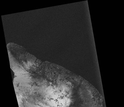
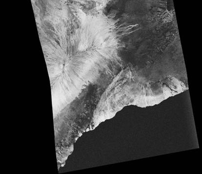
11 Sample result of the InSAR products output from the Browse InSAR processor (SPECAN) : Functionality test master slave coherence fringe

12 Results of Browse-InSAR(2006/8/2-2006/5/2) (Specan Coherence DEM Deformation Amplitude 12

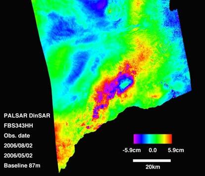

13 Results from FBS DinSAR: 2006/8/2-2006/5/2:Bp=80m (Correlation Coherence DTM Deformation Amplitude 13
14 Operational constraints and achievement for PALSAR SSI T1 time prf11 prf21 prf31 prf41 prf51 1) Normal operation T1 is 1s unit. (Even same latitude is set for the first transmission, 7km dislocates at maximum) prf is tabulated every 100 m height. -> SSI could be done by chance( But, never realized the SSI) prf12 prf22 prf32 prf52 2) Special operation Specify the followings Latitude of argument Five prfs prf42 [Note:Latitude of augment from GPS is biased(0.993km).] -> SSI can be done. 14
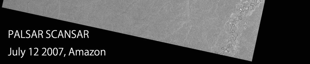
15 SCANSAR SCANSAR InSAR experiments Duration April 2 - April Sites: Sahara, Tanzania, Amazon Mode WB1 and WB2 Master Slave Mode Result Area Bp BS 4/2 2/16 WB1 NG Different location 4/5 2/19 WB1 NG Different location 4/9 2/23 WB2 NG Differs in prf 4/10 2/24 WB1 OK 228m 80% 4/13 2/27 WB1 NG 4/14 2/28 WB1 NG 4/15 2/29 WB1 NG Differs in prf 4/17 3/2 WB1 OK 168m 50% 4/14 2/28 WB2 NG Large Bp 15
16 SCANSAR parameters : Beam synchronization L O Δp j = Lo j L j L No Pulses PRF Duration(s) Length (km) Total Case Master Slave Bp Δp Lo m m m m 16

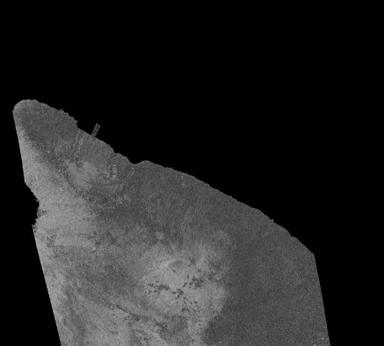
17 Location of the test paths 17


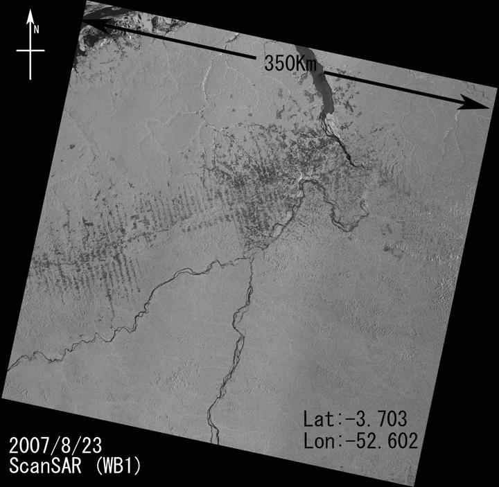
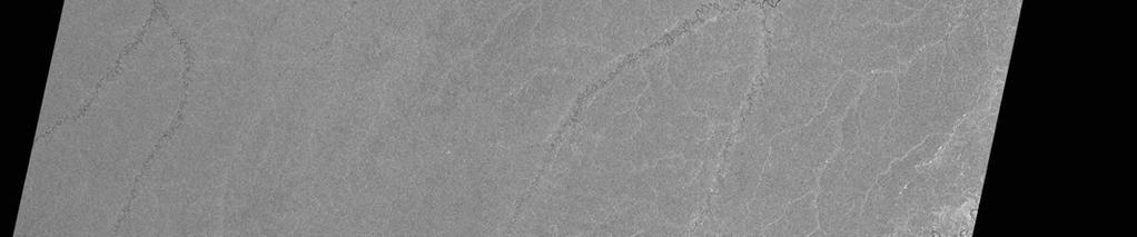
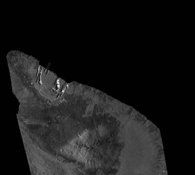
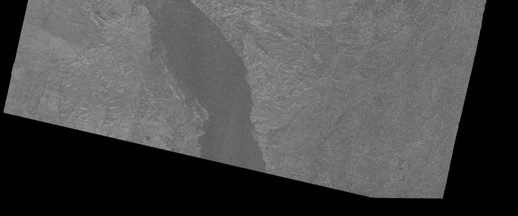
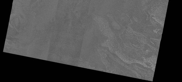
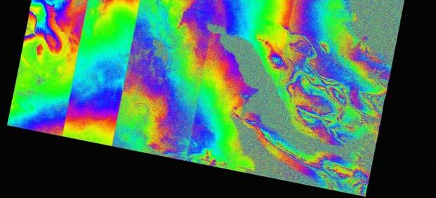
18 350km April 10 - Feb. 24 Bp=~200m BeamS~80% Tanzania Amplitude 18

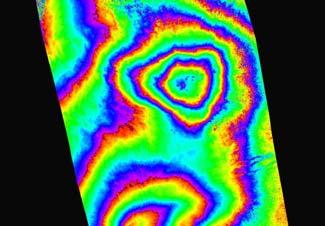
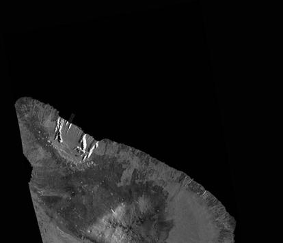
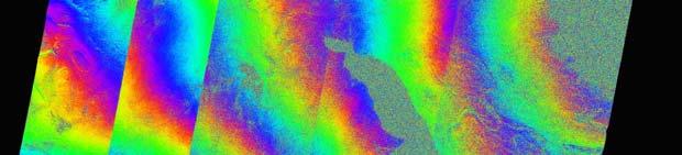
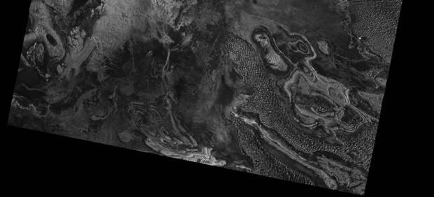
19 Coherence 19

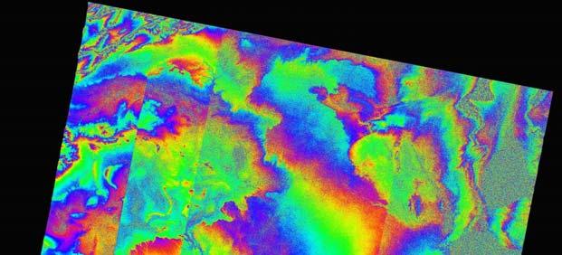
20 Flat earth corrected fringe 20
")
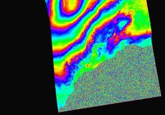
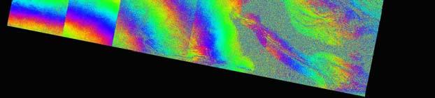
21 Deformation (cancelled for the low frequency) 21


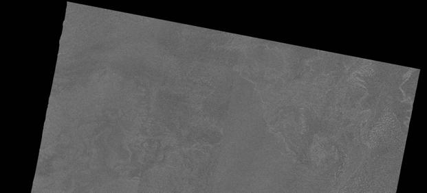
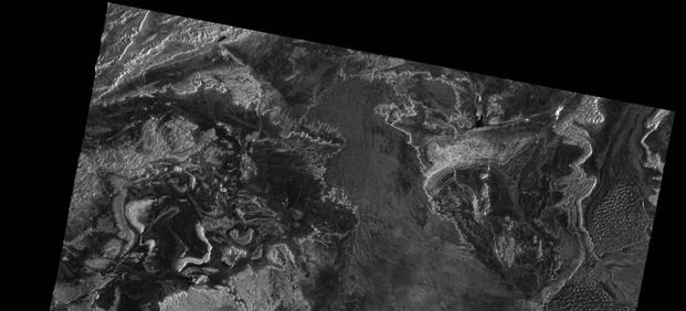


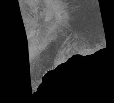
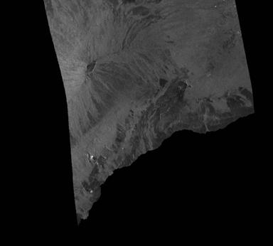
22 Coherence Amplitude RSP325 Sahara 2008/4/ /3/2 Bp=~100m BeamS~50% DTM Deformation 22


23 SCANSAR data archives 23 WB1 WB2 May Oct
24 Conclusions PALSAR SCANSAR SCANSAR Interferometry has been examined and succeeded by conducting the beam synchronization with the previous images. The parameters are the PRFs and augment of latitude for the first scan. Two examples out of 9 examples show that 80% and even 50% of the beam synchronization can produce the SSI over the dense forest and desert of Africa. It promises that PALSAR can provide the SCANSAR SCANSAR Interferometry for wide range of the target, i.e., earthquake, Antarctica, Greenland monitoring. Further research Correction of the SCAN-SCAN phase offset Correction of the atmospheric error and orbital errors. Improvement of the processing speed Trial for Full aperture type processing
The Current Status and Brief Results of Engineering Model for PALSAR-2 onboard ALOS-2 and Science Project
 The Current Status and Brief Results of Engineering Model for PALSAR-2 onboard ALOS-2 and Science Project + The 16 th KC meeting Japan Aerospace Exploration Agency Masanobu Shimada, Yukihiro KANKAKU The
European Space Agency and IPY
 European Space Agency and IPY ESA supports IPY 2007-2008 activities: First ESA step was a dedicated Announcement Opportunity (AO) for EO data provision in support IPY, released in 2006, with data provision
Concept of the future L-band SAR mission for wide swath SAR observation
 Concept of the future SAR mission for wide swath SAR observation A.Karasawa 1, Y.Okada 1, Y.Yokota 1, S.Nakamura 1 1) Mitsubishi Electric Corporation 1 Outline 1:Development of SAR systems in MELCO 2:Development
ALOS and PALSAR. Masanobu Shimada
 ALOS and PALSAR Masanobu Shimada Earth Observation Research Center, National Space Development Agency of Japan, Harumi 1-8-10, Harumi island triton square office tower X 22, Chuo-Ku, Tokyo-To, Japan, 104-6023,
OVERVIEW OF THE ALOS SATELLITE SYSTEM
 OVERVIEW OF THE ALOS SATELLITE SYSTEM Presented to The Symposium for ALOS Data Application Users @Kogakuin University, Tokyo, Japan Mar. 27, 2001 Takashi Hamazaki Senior Engineer ALOS Project National
KOMPSAT Constellation. November 2012 Satrec Initiative
 KOMPSAT Constellation November 2012 Satrec Initiative KOMPSAT Constellation KOMPSAT National program Developed and operated by KARI (Korea Aerospace Research Institute) Dual use : Government & commercial
SARscape Modules for ENVI
 Visual Information Solutions SARscape Modules for ENVI Read, process, analyze, and output products from SAR data. ENVI. Easy to Use Tools. Proven Functionality. Fast Results. DEM, based on TerraSAR-X-1
TanDEM-X: Mission Status & Scientific Contribution
 TanDEM-X: Mission Status & Scientific Contribution Irena Hajnsek 1/2, Gerhard Krieger 1, Kostas Papathanassiou 1, Stefan Baumgartner 1, Marc Rodriguez-Cassola 1, Pau Prats 1, Maria Sanjuan Ferrer 1, Florian
KEY TECHNOLOGY DEVELOPMENT FOR THE ADVENACED LAND OBSERVING SATELLITE
 KEY TECHNOLOGY DEVELOPMENT FOR THE ADVENACED LAND OBSERVING SATELLITE Takashi HAMAZAKI, and Yuji OSAWA National Space Development Agency of Japan (NASDA) hamazaki.takashi@nasda.go.jp yuji.osawa@nasda.go.jp
Earth Observation and Sensing Technologies: a focus on Radar Imaging Developments. Riccardo Lanari
 Earth Observation and Sensing Technologies: a focus on Radar Imaging Developments Riccardo Lanari Institute for Electromagnetic Sensing of the Environment (IREA) National Research Council of Italy (CNR)
Sub-Mesoscale Imaging of the Ionosphere with SMAP
 Sub-Mesoscale Imaging of the Ionosphere with SMAP Tony Freeman Xiaoqing Pi Xiaoyan Zhou CEOS Workshop, ASF, Fairbanks, Alaska, December 2009 1 Soil Moisture Active-Passive (SMAP) Overview Baseline Mission
ESA Radar Remote Sensing Course ESA Radar Remote Sensing Course Radar, SAR, InSAR; a first introduction
 Radar, SAR, InSAR; a first introduction Ramon Hanssen Delft University of Technology The Netherlands r.f.hanssen@tudelft.nl Charles University in Prague Contents Radar background and fundamentals Imaging
Nadir Margins in TerraSAR-X Timing Commanding
 CEOS SAR Calibration and Validation Workshop 2008 1 Nadir Margins in TerraSAR-X Timing Commanding S. Wollstadt and J. Mittermayer, Member, IEEE Abstract This paper presents an analysis and discussion of
RADAR INTERFEROMETRY FOR SAFE COAL MINING IN CHINA
 RADAR INTERFEROMETRY FOR SAFE COAL MINING IN CHINA L. Ge a, H.-C. Chang a, A. H. Ng b and C. Rizos a Cooperative Research Centre for Spatial Information School of Surveying & Spatial Information Systems,
All rights reserved. ENVI, IDL and Jagwire are trademarks of Exelis, Inc. All other marks are the property of their respective owners.
 SAR Analysis Made Easy with SARscape 5.1 All rights reserved. ENVI, IDL and Jagwire are trademarks of Exelis, Inc. All other marks are the property of their respective owners. 2014, Exelis Visual Information
Francesco Holecz. TUBE II meeting - 17 June Land Degradation. Land Degradation
 Land Degradation Francesco Holecz Objective To identify and monitor land degraded areas, in particular those related to agricultural and pastoral activities. Following products are generated: Land cover
Global 25 m Resolution PALSAR-2/PALSAR Mosaic. and Forest/Non-Forest Map (FNF) Dataset Description
 Dataset Description") Global 25 m Resolution PALSAR-2/PALSAR Mosaic and Forest/Non-Forest Map (FNF) Dataset Description Japan Aerospace Exploration Agency (JAXA) Earth Observation Research Center (EORC) 1 Revision history Version
Global 25 m Resolution PALSAR-2/PALSAR Mosaic and Forest/Non-Forest Map (FNF) Dataset Description Japan Aerospace Exploration Agency (JAXA) Earth Observation Research Center (EORC) 1 Revision history Version
Contributions of the Remote Sensing by Earth Observation Satellites on Engineering Geology
 10th Asian Regional Conference of IAEG (2015) Contributions of the Remote Sensing by Earth Observation Satellites on Engineering Geology Takeo TADONO (1), Hiroto NAGAI (1), Atsuko NONOMURA (2) and Ryoichi
HEMERA Constellation of passive SAR-based micro-satellites for a Master/Slave configuration
 HEMERA Constellation of passive SAR-based micro-satellites for a Master/Slave HEMERA Team Members: Andrea Bellome, Giulia Broggi, Luca Collettini, Davide Di Ienno, Edoardo Fornari, Leandro Lucchese, Andrea
Monitoring the Earth Surface from space
 Monitoring the Earth Surface from space Picture of the surface from optical Imagery, i.e. obtained by telescopes or cameras operating in visual bandwith. Shape of the surface from radar imagery Surface
Review. Guoqing Sun Department of Geography, University of Maryland ABrief
 Review Guoqing Sun Department of Geography, University of Maryland gsun@glue.umd.edu ABrief Introduction Scattering Mechanisms and Radar Image Characteristics Data Availability Example of Applications
Generation of Fine Resolution DEM at Test Areas in Alaska Using ERS SAR Tandem Pairs and Precise Orbital Data *
 Generation of Fine Resolution DEM at Test Areas in Alaska Using ERS SAR Tandem Pairs and Precise Orbital Data * O. Lawlor, T. Logan, R. Guritz, R. Fatland, S. Li, Z. Wang, and C. Olmsted Alaska SAR Facility
Remote sensing radio applications/ systems for environmental monitoring
 Remote sensing radio applications/ systems for environmental monitoring Alexandre VASSILIEV ITU Radiocommunication Bureau phone: +41 22 7305924 e-mail: alexandre.vassiliev@itu.int 1 Source: European Space
Trainings and capacity buildings of space
 Trainings and capacity buildings of space technology, GIS and SAR products development for disaster management for DAN Dr. Masahiko NAGAI, Prof. Ryosuke Shibasaki Center for Spatial Information Science,
MULTI-CHANNEL SAR EXPERIMENTS FROM THE SPACE AND FROM GROUND: POTENTIAL EVOLUTION OF PRESENT GENERATION SPACEBORNE SAR
 3 nd International Workshop on Science and Applications of SAR Polarimetry and Polarimetric Interferometry POLinSAR 2007 January 25, 2007 ESA/ESRIN Frascati, Italy MULTI-CHANNEL SAR EXPERIMENTS FROM THE
Sentinel-1 System Overview
 Sentinel-1 System Overview Dirk Geudtner, Rámon Torres, Paul Snoeij, Malcolm Davidson European Space Agency, ESTEC Global Monitoring for Environment and Security (GMES) EU-led program aiming at providing
Global 25 m Resolution PALSAR-2/PALSAR Mosaic. and Forest/Non-Forest Map (FNF) Dataset Description
 Dataset Description") Global 25 m Resolution PALSAR-2/PALSAR Mosaic and Forest/Non-Forest Map (FNF) Dataset Description Japan Aerospace Exploration Agency (JAXA) Earth Observation Research Center (EORC) 1 Revision history Version
Global 25 m Resolution PALSAR-2/PALSAR Mosaic and Forest/Non-Forest Map (FNF) Dataset Description Japan Aerospace Exploration Agency (JAXA) Earth Observation Research Center (EORC) 1 Revision history Version
XSAT Ground Segment at CRISP
 XSAT Ground Segment at CRISP LIEW Soo Chin Head of Research, CRISP http://www.crisp.nus.edu.sg 5 th JPTM for Sentinel Asia Step-2, 14-16 Nov 2012, Daejeon, Korea Centre for Remote Imaging, Sensing and
IMPACT OF BAQ LEVEL ON INSAR PERFORMANCE OF RADARSAT-2 EXTENDED SWATH BEAM MODES
 IMPACT OF BAQ LEVEL ON INSAR PERFORMANCE OF RADARSAT-2 EXTENDED SWATH BEAM MODES Jayson Eppler (1), Mike Kubanski (1) (1) MDA Systems Ltd., 13800 Commerce Parkway, Richmond, British Columbia, Canada, V6V
ASAR Training Course, Hanoi, 25 February 7 March 2008 Introduction to Radar Interferometry
 Introduction to Radar Interferometry Presenter: F.Sarti (ESA/ESRIN) 1 Imaging Radar : reminder 2 Physics of radar Potentialities of radar All-weather observation system (active system) Penetration capabilities
SAR Interferometry Capabilities of Canada's planned SAR Satellite Constellation
 SAR Interferometry Capabilities of Canada's planned SAR Satellite Constellation Dirk Geudtner, Guy Séguin,, Ralph Girard Canadian Space Agency RADARSAT Follow-on Program CSA is in the middle of a Phase
SAR Remote Sensing (Microwave Remote Sensing)
") iirs SAR Remote Sensing (Microwave Remote Sensing) Synthetic Aperture Radar Shashi Kumar shashi@iirs.gov.in Electromagnetic Radiation Electromagnetic radiation consists of an electrical field(e) which
iirs SAR Remote Sensing (Microwave Remote Sensing) Synthetic Aperture Radar Shashi Kumar shashi@iirs.gov.in Electromagnetic Radiation Electromagnetic radiation consists of an electrical field(e) which
Biomass, a polarimetric interferometric P-band SAR mission
 Biomass, a polarimetric interferometric P-band SAR mission M. Arcioni, P. Bensi, M. Fehringer, F. Fois, F. Heliere, N. Miranda, K. Scipal Fringe 2015, ESRIN 27/03/2015 The Biomass Mission 1. Biomass was
Envisat and ERS missions: data and services
 FRINGE 2005 Workshop Envisat and ERS missions: and services Henri LAUR Envisat Mission Manager Our top objective: ease access to Earth Observation Common objective for all missions handled by ESA: Envisat,
A SAR Conjugate Mirror
 A SAR Conjugate Mirror David Hounam German Aerospace Center, DLR, Microwaves and Radar Institute Oberpfaffenhofen, D-82234 Wessling, Germany Fax: +49 8153 28 1449, E-Mail: David.Hounam@dlr.de Abstract--
A Review of Ionospheric Effects in Low-Frequency SAR Data
 A Review of Ionospheric Effects in Low-Frequency SAR Data Signals, Correction Methods, and Performance Requirements F.J Meyer 1) 2), P. Rosen, A. Freeman, K. Papathanassiou, J. Nicoll, B. Watkins, M. Eineder,
Advanced Optical Satellite (ALOS-3) Overviews
 Overviews") K&C Science Team meeting #24 Tokyo, Japan, January 29-31, 2018 Advanced Optical Satellite (ALOS-3) Overviews January 30, 2018 Takeo Tadono 1, Hidenori Watarai 1, Ayano Oka 1, Yousei Mizukami 1, Junichi
K&C Science Team meeting #24 Tokyo, Japan, January 29-31, 2018 Advanced Optical Satellite (ALOS-3) Overviews January 30, 2018 Takeo Tadono 1, Hidenori Watarai 1, Ayano Oka 1, Yousei Mizukami 1, Junichi
Ionospheric Propagation Effects on W de Bandwidth Sig Si nals Dennis L. Knepp NorthWest Research NorthW Associates est Research Monterey California
 Ionospheric Propagation Effects on Wide Bandwidth Signals Dennis L. Knepp NorthWest Research Associates 2008 URSI General Assembly Chicago, August 2008 Ionospheric Effects on Propagating Signals Mean effects:
RADAR REMOTE SENSING
 RADAR REMOTE SENSING Jan G.P.W. Clevers & Steven M. de Jong Chapter 8 of L&K 1 Wave theory for the EMS: Section 1.2 of L&K E = electrical field M = magnetic field c = speed of light : propagation direction
SARscape for ENVI. A Complete SAR Analysis Solution
 SARscape for ENVI A Complete SAR Analysis Solution IDL and ENVI A Foundation for SARscape IDL The Data Analysis & Visualization Platform Data Access: IDL supports virtually every data format, type and
Chapter 6 Spaceborne SAR Antennas for Earth Science
 Chapter 6 Spaceborne SAR Antennas for Earth Science Yunjin Kim and Rolando L. Jordan 6.1 Introduction Before the development of the first synthetic aperture radar (SAR) antenna flown in space, Jet Propulsion
MULTIPLE APERTURE INSAR (MAI) WITH C-BAND AND L-BAND DATA: NOISE AND PRECISION
 WITH C-BAND AND L-BAND DATA: NOISE AND PRECISION") MULTIPLE APERTURE INSAR (MAI) WITH C-BAND AND L-BAND DATA: NOISE AND PRECISION Noa Bechor Ben-Dov and Thomas A. Herring Massachusetts Institute of Technology, Cambridge, MA 2139, USA, Email: nbechor@chandler.mit.edu
MULTIPLE APERTURE INSAR (MAI) WITH C-BAND AND L-BAND DATA: NOISE AND PRECISION Noa Bechor Ben-Dov and Thomas A. Herring Massachusetts Institute of Technology, Cambridge, MA 2139, USA, Email: nbechor@chandler.mit.edu
Introduction to radar. interferometry
 Introduction to radar Introduction to Radar Interferometry interferometry Presenter: F.Sarti (ESA/ESRIN) With kind contribution by the Radar Department of CNES All-weather observation system (active system)
Environmental Impact Assessment of Mining Subsidence by Using Spaceborne Radar Interferometry
 Environmental Impact Assessment of Mining Subsidence by Using Spaceborne Radar Interferometry Hsing-Chung CHANG, Linlin GE and Chris RIZOS, Australia Key words: Mining Subsidence, InSAR, DInSAR, DEM. SUMMARY
ANALYSIS OF SRTM HEIGHT MODELS
 ANALYSIS OF SRTM HEIGHT MODELS Sefercik, U. *, Jacobsen, K.** * Karaelmas University, Zonguldak, Turkey, ugsefercik@hotmail.com **Institute of Photogrammetry and GeoInformation, University of Hannover,
TerraSAR-X Applications Guide
 TerraSAR-X Applications Guide Extract: Change Detection and Monitoring: Geospatial / Image Intelligence April 2015 Airbus Defence and Space Geo-Intelligence Programme Line Change Detection and Monitoring:
CryoSat footprints. Aresys Technical Note. ESA Document REF. Issue 1.1 Date 6 March 2013 Pages 8. Michele Scagliola ARESYS S.r.l
 CryoSat footprints Aresys Technical Note ESA Document REF XCRY-GSEG-EOPG-TN-13-0013 Aresys Internal REF SAR-CRY2-TEN-6331 Issue 1.1 Date 6 March 2013 Pages 8 Author Michele Scagliola ARESYS S.r.l Signature
Faraday rotation estimation from unfocussed ALOS PALSAR raw data
 Faraday rotation estimation from unfocussed ALOS PALSAR raw data arco Lavalle 1 3, E. Pottier 2, D. Solimini 1, N. iranda 3 1 DISP, Tor Vergata University, Rome, Italy 2 IETR UR CNRS 6164, University of
VenSAR: A MULTI-FUNCTIONAL S-BAND RADAR FOR THE EnVision MISSION TO VENUS
 VenSAR: A MULTI-FUNCTIONAL S-BAND RADAR FOR THE EnVision MISSION TO VENUS Richard Ghail (1) and David Hall (2) (1) Civil and Environmental Engineering, Imperial College London, London SW7 2AZ, United Kingdom
Radar and Satellite Remote Sensing. Chris Allen, Associate Director Technology Center for Remote Sensing of Ice Sheets The University of Kansas
 Radar and Satellite Remote Sensing Chris Allen, Associate Director Technology Center for Remote Sensing of Ice Sheets The University of Kansas 2of 43 Outline Background ice sheet characterization Radar
Space-Time Adaptive Processing Using Sparse Arrays
 Space-Time Adaptive Processing Using Sparse Arrays Michael Zatman 11 th Annual ASAP Workshop March 11 th -14 th 2003 This work was sponsored by the DARPA under Air Force Contract F19628-00-C-0002. Opinions,
Simulation study for the Stratospheric Inferred Wind (SIW) sub-millimeter limb sounder
 sub-millimeter limb sounder") Simulation study for the Stratospheric Inferred Wind (SIW) sub-millimeter limb sounder Philippe Baron1, Donal Murtagh2 (PI), Patrick Eriksson2, Kristell Pérot2 and Satoshi Ochiai1 (1) National Institute
Simulation study for the Stratospheric Inferred Wind (SIW) sub-millimeter limb sounder Philippe Baron1, Donal Murtagh2 (PI), Patrick Eriksson2, Kristell Pérot2 and Satoshi Ochiai1 (1) National Institute
SCANSAR AND SPOTLIGHT IMAGING OPERATION STUDY FOR SAR SATELLITE MISSION
 SCANSAR AND SPOTLIGHT IMAGING OPERATION STUDY FOR SAR SATELLITE MISSION Bor-Han Wu, Meng-Che Wu and Ming-Hwang Shie National Space Organization, National Applied Research Laboratory, Taiwan *Corresponding
Sentinel-1 Overview. Dr. Andrea Minchella
 Dr. Andrea Minchella 21-22/01/2016 ESA SNAP-Sentinel-1 Training Course Satellite Applications Catapult - Electron Building, Harwell, Oxfordshire Contents Sentinel-1 Mission Sentinel-1 SAR Modes Sentinel-1
Principles of Remote Sensing. Shuttle Radar Topography Mission S R T M. Michiel Damen. Dept. Earth Systems Analysis
 Principles of Remote Sensing Shuttle Radar Topography Mission S R T M Michiel Damen Dept. Earth Systems Analysis Contents Present problems with DEMs Advantage of SRTM Cell size Mission and system Radar
Polarisation Capabilities and Status of TerraSAR-X
 Polarisation Capabilities and Status of TerraSAR-X Irena Hajnsek, Josef Mittermayer, Stefan Buckreuss, Kostas Papathanassiou German Aerospace Center Microwaves and Radar Institute irena.hajnsek@dlr.de
TanDEM-X Mission Status & Commissioning Phase Overview
 TanDEM-X Mission Status & Commissioning Phase Overview M. Zink TanDEM-X Ground Segment Manager 17-February-2011 TanDEM-X Science Team Meeting 17-Feb-2011 - OP TerraSAR-X-Add-on for Digital Elevation Measurements
Ge111A Remote Sensing and GIS Lecture
 Ge111A Remote Sensing and GIS Lecture Remote Sensing - many different geophysical data sets. We concentrate on the following: Imagery (optical and radar) Topography Geographical Information Systems (GIS)
Canadian Space Agency Contribution to STG
 Canadian Space Agency Contribution to STG Canadian Space Agency 1 STG5 Geneva, Nov 30 to Dec 2, 2009 2 Canadian Space Agency ASAP Portefolio: Name Frozen Baseline Sea Ice Min and Max Snapshots Fine Image
ALOS-2 followon shimada-masanobu
 ALOS-2 followon-2020 shimada-masanobu 25m resolution global mosaic using PALSAR-2 FBD data Old ver. of 2015 Mosaic (Africa) Stripes in the old version of mosaic 2015 PALSAR-2 25m Global Mosaic New ver.
Synthetic Aperture Radar Interferometry (InSAR) Technique (Lecture I- Tuesday 11 May 2010)
 Technique (Lecture I- Tuesday 11 May 2010)") Synthetic Aperture Radar Interferometry () Technique (Lecture I- Tuesday 11 May 2010) ISNET/CRTEAN Training Course on Synthetic Aperture Radar (SAR) Imagery: Processing, Interpretation and Applications
Synthetic Aperture Radar Interferometry () Technique (Lecture I- Tuesday 11 May 2010) ISNET/CRTEAN Training Course on Synthetic Aperture Radar (SAR) Imagery: Processing, Interpretation and Applications
Fringe 2015 Workshop
 Fringe 2015 Workshop On the Estimation and Interpretation of Sentinel-1 TOPS InSAR Coherence Urs Wegmüller, Maurizio Santoro, Charles Werner and Oliver Cartus Gamma Remote Sensing AG - S1 IWS InSAR and
HIGH RESOLUTION DIFFERENTIAL INTERFEROMETRY USING TIME SERIES OF ERS AND ENVISAT SAR DATA
 HIGH RESOLUTION DIFFERENTIAL INTERFEROMETRY USING TIME SERIES OF ERS AND ENVISAT SAR DATA Javier Duro 1, Josep Closa 1, Erlinda Biescas 2, Michele Crosetto 2, Alain Arnaud 1 1 Altamira Information C/ Roger
Concept Design of Space-Borne Radars for Tsunami Detection
 Concept Design of Space-Borne Radars for Tsunami Detection DLR German Aerospace Agency +Microwaves and Radar Institute *Remote Sensing Institute +Michele Galletti +Gerhard Krieger +Nicolas Marquart +Thomas
RADARSAT-2 Program Update Daniel De Lisle Canadian Space Agency
 RADARSAT-2 Program Update Daniel De Lisle Canadian Space Agency Presentation outline RADARSAT-1 Update RADARSAT-2 Mission description Mission Objectives System Characteristics Data Commercialization/Allocation
EE 529 Remote Sensing Techniques. Introduction
 EE 529 Remote Sensing Techniques Introduction Course Contents Radar Imaging Sensors Imaging Sensors Imaging Algorithms Imaging Algorithms Course Contents (Cont( Cont d) Simulated Raw Data y r Processing
Introduction to KOMPSAT
 Introduction to KOMPSAT September, 2016 1 CONTENTS 01 Introduction of SIIS 02 KOMPSAT Constellation 03 New : KOMPSAT-3 50 cm 04 New : KOMPSAT-3A 2 KOMPSAT Constellation KOMPSAT series National space program
GMES Sentinel-1 Transponder Development
 GMES Sentinel-1 Transponder Development Paul Snoeij Evert Attema Björn Rommen Nicolas Floury Malcolm Davidson ESA/ESTEC, European Space Agency, Noordwijk, The Netherlands Outline 1. GMES Sentinel-1 overview
Damage detection in the 2015 Nepal earthquake using ALOS-2 satellite SAR imagery
 Proceedings of the Tenth Pacific Conference on Earthquake Engineering Building an Earthquake-Resilient Pacific 6-8 November 2015, Sydney, Australia Damage detection in the 2015 Nepal earthquake using ALOS-2
URBAN MONITORING USING PERSISTENT SCATTERER INSAR AND PHOTOGRAMMETRY
 URBAN MONITORING USING PERSISTENT SCATTERER INSAR AND PHOTOGRAMMETRY Junghum Yu *, Alex Hay-Man Ng, Sungheuk Jung, Linlin Ge, and Chris Rizos. School of Surveying and Spatial Information Systems, University
A Combined Multi-Temporal InSAR Method: Incorporating Persistent Scatterer and Small Baseline Approaches. Andy Hooper University of Iceland
 A Combined Multi-Temporal InSAR Method: Incorporating Persistent Scatterer and Small Baseline Approaches Andy Hooper University of Iceland Time Multi-Temporal InSAR Same area imaged each time Multi-Temporal
Basic Radar Definitions Introduction p. 1 Basic relations p. 1 The radar equation p. 4 Transmitter power p. 9 Other forms of radar equation p.
 Basic Radar Definitions Basic relations p. 1 The radar equation p. 4 Transmitter power p. 9 Other forms of radar equation p. 11 Decibel representation of the radar equation p. 13 Radar frequencies p. 15
THE NASA/JPL AIRBORNE SYNTHETIC APERTURE RADAR SYSTEM. Yunling Lou, Yunjin Kim, and Jakob van Zyl
 THE NASA/JPL AIRBORNE SYNTHETIC APERTURE RADAR SYSTEM Yunling Lou, Yunjin Kim, and Jakob van Zyl Jet Propulsion Laboratory California Institute of Technology 4800 Oak Grove Drive, MS 300-243 Pasadena,
Synthetic Aperture Radar
 Synthetic Aperture Radar Picture 1: Radar silhouette of a ship, produced with the ISAR-Processor of the Ocean Master A Synthetic Aperture Radar (SAR), or SAR, is a coherent mostly airborne or spaceborne
DEMS BASED ON SPACE IMAGES VERSUS SRTM HEIGHT MODELS. Karsten Jacobsen. University of Hannover, Germany
 DEMS BASED ON SPACE IMAGES VERSUS SRTM HEIGHT MODELS Karsten Jacobsen University of Hannover, Germany jacobsen@ipi.uni-hannover.de Key words: DEM, space images, SRTM InSAR, quality assessment ABSTRACT
Synthetic aperture RADAR (SAR) principles/instruments October 31, 2018
 principles/instruments October 31, 2018") GEOL 1460/2461 Ramsey Introduction to Remote Sensing Fall, 2018 Synthetic aperture RADAR (SAR) principles/instruments October 31, 2018 I. Reminder: Upcoming Dates lab #2 reports due by the start of next
GEOL 1460/2461 Ramsey Introduction to Remote Sensing Fall, 2018 Synthetic aperture RADAR (SAR) principles/instruments October 31, 2018 I. Reminder: Upcoming Dates lab #2 reports due by the start of next
Earth Observation from a Moon based SAR: Potentials and Limitations
 Earth Observation from a Moon based SAR: Potentials and Limitations F. Bovenga 1, M. Calamia 2,3, G. Fornaro 5, G. Franceschetti 4, L. Guerriero 1, F. Lombardini 5, A. Mori 2 1 Politecnico di Bari - Dipartimento
RECOMMENDATION ITU-R S *
 Rec. ITU-R S.1339-1 1 RECOMMENDATION ITU-R S.1339-1* Rec. ITU-R S.1339-1 SHARING BETWEEN SPACEBORNE PASSIVE SENSORS OF THE EARTH EXPLORATION-SATELLITE SERVICE AND INTER-SATELLITE LINKS OF GEOSTATIONARY-SATELLITE
An Improved DBF Processor with a Large Receiving Antenna for Echoes Separation in Spaceborne SAR
 Progress In Electromagnetics Research C, Vol. 67, 49 57, 216 An Improved DBF Processor a Large Receiving Antenna for Echoes Separation in Spaceborne SAR Hongbo Mo 1, *,WeiXu 2, and Zhimin Zeng 1 Abstract
Wave Sensing Radar and Wave Reconstruction
 Applied Physical Sciences Corp. 475 Bridge Street, Suite 100, Groton, CT 06340 (860) 448-3253 www.aphysci.com Wave Sensing Radar and Wave Reconstruction Gordon Farquharson, John Mower, and Bill Plant (APL-UW)
SYSTEM ARCHITECTURE OF RADAR NETWORK FOR MONITORING OF HAZARDOUD WEATHER
 SYSTEM ARCHITECTURE OF RADAR NETWORK FOR MONITORING OF HAZARDOUD WEATHER 2008. 11. 21 HOON LEE Gwangju Institute of Science and Technology &. CONTENTS 1. Backgrounds 2. Pulse Compression 3. Radar Network
Interferometric Cartwheel 1
 The Interferometric CartWheel A wheel of passive radar microsatellites for upgrading existing SAR projects D. Massonnet, P. Ultré-Guérard (DPI/EOT) E. Thouvenot (DTS/AE/INS/IR) Interferometric Cartwheel
Principles of Pulse-Doppler Radar p. 1 Types of Doppler Radar p. 1 Definitions p. 5 Doppler Shift p. 5 Translation to Zero Intermediate Frequency p.
 Preface p. xv Principles of Pulse-Doppler Radar p. 1 Types of Doppler Radar p. 1 Definitions p. 5 Doppler Shift p. 5 Translation to Zero Intermediate Frequency p. 6 Doppler Ambiguities and Blind Speeds
How accurately can current and futureinsar missions map tectonic strain?
 How accurately can current and futureinsar missions map tectonic strain? Outline: How accurately do we need to measure strain? InSAR missions Error budget for InSAR Ability of current, planned and proposed
Potential interference from spaceborne active sensors into radionavigation-satellite service receivers in the MHz band
 Rec. ITU-R RS.1347 1 RECOMMENDATION ITU-R RS.1347* Rec. ITU-R RS.1347 FEASIBILITY OF SHARING BETWEEN RADIONAVIGATION-SATELLITE SERVICE RECEIVERS AND THE EARTH EXPLORATION-SATELLITE (ACTIVE) AND SPACE RESEARCH
Futrajaya, Malaysia JULY 12, Jeong Heon SONG. Korea Aerospace Research Institution
 J P T M 2 0 1 1 Futrajaya, Malaysia JULY 12, 2011 Jeong Heon SONG Korea Aerospace Research Institution Outline Contribution of KARI Sentinel Asia / Data Provider Node International Charter KARI Space Activities
RECENT ADVANCES IN THE CORRECTION OF IONOSPHERIC EFFECTS IN LOW-FREQUENCY SAR DATA
 RECENT ADVANCES IN THE CORRECTION OF IONOSPHERIC EFFECTS IN LOW-FREQUENCY SAR DATA F.J Meyer 1) 2), B. Watkins 3), J.S. Kim 4), K. Papathanassiou 4) 1)Earth & Planetary Remote Sensing, University of Alaska
TerraSAR-X Mission: Application and Data Access
 TerraSAR-X Mission: Application and Data Access Irena Hajnsek & TSX TEAM German Aerospace Center Microwaves and Radar Institute Pol-InSAR Research Group 2 years in Orbit (since June 2007) irena.hajnsek@dlr.de
Active microwave systems (1) Satellite Altimetry
 Satellite Altimetry") Remote Sensing: John Wilkin Active microwave systems (1) Satellite Altimetry jwilkin@rutgers.edu IMCS Building Room 214C 732-932-6555 ext 251 Active microwave instruments Scatterometer (scattering from
Remote Sensing: John Wilkin Active microwave systems (1) Satellite Altimetry jwilkin@rutgers.edu IMCS Building Room 214C 732-932-6555 ext 251 Active microwave instruments Scatterometer (scattering from
The Tandem-L Formation
 The Tandem-L Formation G. Krieger, I. Hajnsek, K. Papathanassiou, M. Eineder, M. Younis, F. De Zan, P. Prats, S. Huber, M. Werner, A. Freeman +, P. Rosen +, S. Hensley +, W. Johnson +, L. Veilleux +, B.
Detection of a Point Target Movement with SAR Interferometry
 Journal of the Korean Society of Remote Sensing, Vol.16, No.4, 2000, pp.355~365 Detection of a Point Target Movement with SAR Interferometry Jung-Hee Jun* and Min-Ho Ka** Agency for Defence Development*,
9/12/2011. Training Course Remote Sensing Basic Theory & Image Processing Methods September 2011
 Training Course Remote Sensing Basic Theory & Image Processing Methods 19 23 September 2011 Popular Remote Sensing Sensors & their Selection Michiel Damen (September 2011) damen@itc.nl 1 Overview Low resolution
Introduction Active microwave Radar
 RADAR Imaging Introduction 2 Introduction Active microwave Radar Passive remote sensing systems record electromagnetic energy that was reflected or emitted from the surface of the Earth. There are also
Development of the Technology of Utilization of Airborne Synthetic Aperture Radar (SAR)
") Development of the Technology of Utilization of Airborne Synthetic Aperture Radar (SAR) Mamoru Koarai, Kouichi Moteki, Nobuyuki Watanabe, Takaki Okatani,Youko Yamada and Kaoru Matsuo Geographical Survey
Development of the Technology of Utilization of Airborne Synthetic Aperture Radar (SAR) Mamoru Koarai, Kouichi Moteki, Nobuyuki Watanabe, Takaki Okatani,Youko Yamada and Kaoru Matsuo Geographical Survey
Synthetic Aperture Radar. Hugh Griffiths THALES/Royal Academy of Engineering Chair of RF Sensors University College London
 Synthetic Aperture Radar Hugh Griffiths THALES/Royal Academy of Engineering Chair of RF Sensors University College London CEOI Training Workshop Designing and Delivering and Instrument Concept 15 March
FIRST DATA ACQUISITION AND PROCESSING CONCEPTS FOR THE TANDEM-X MISSION
 FIRST DATA ACQUISITION AND PROCESSING CONCEPTS FOR THE TANDEM-X MISSION M. Eineder, G. Krieger, A. Roth German Aerospace Center DLR 82234 Wessling, Oberpfaffenhofen, Germany KEY WORDS: Earth Observation,
Terrain Motion and Persistent Scatterer InSAR
 Terrain Motion and Persistent Scatterer InSAR Andy Hooper University of Leeds ESA Land Training Course, Gödöllő, Hungary, 4-9 th September, 2017 Good Interferogram 2011 Tohoku earthquake Good correlation
Improvement and Validation of Ranging Accuracy with YG-13A
 Article Improvement and Validation of Ranging Accuracy with YG-13A Mingjun Deng 1, Guo Zhang 2, *, Ruishan Zhao 3, Jiansong Li 1, Shaoning Li 2 1 School of Remote Sensing and Information Engineering, Wuhan
Time Trend Evaluations of Absolute Accuracies for PRISM and AVNIR-2
 The 3 rd ALOS Joint PI Symposium, Kona, Hawaii, US Nov. 9-13, 2009 Time Trend Evaluations of Absolute Accuracies for PRISM and AVNIR-2 Takeo Tadono*, Masanobu Shimada*, Hiroshi Murakami*, Junichi Takaku**,
ASAR WIDE-SWATH SINGLE-LOOK COMPLEX PRODUCTS: PROCESSING AND EXPLOITATION POTENTIAL
 ASAR WIDE-SWATH SINGLE-LOOK COMPLEX PRODUCTS: PROCESSING AND EXPLOITATION POTENTIAL Ralph Cordey (1), Tim Pearson (2), Yves-Louis Desnos (3), Betlem Rosich-Tell (3) (1) European Space Agency, ESTEC, Keplerlaan