TanDEM-X Mission Status & Commissioning Phase Overview
|
|
|
- Lily Austin
- 6 years ago
- Views:
Transcription


1 TanDEM-X Mission Status & Commissioning Phase Overview M. Zink TanDEM-X Ground Segment Manager 17-February-2011 TanDEM-X Science Team Meeting 17-Feb OP
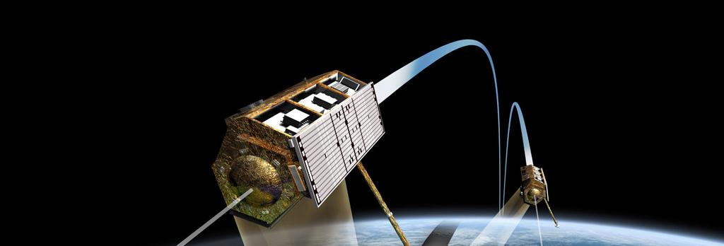


2 TerraSAR-X-Add-on for Digital Elevation Measurements Page 2
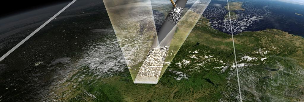
3 Add-ons for TanDEM-X (1/2) Second Satellite (close copy, only minor modifications) Measures for save formation flight (inter satellite link, exclusion zones, new magnet torquer safe mode, sync warning) Satellite operations in close formation (more frequent S-Band contacts for monitoring, novel sub-systems for orbit and formation monitoring & control) Advanced power/thermal model allows for operational profiles beyond design specification limits (in average 210s active/130s passive per orbit) Dedicated TanDEM-X Acquisition Planner considering height performance and system resources Page 3
4 Add-ons for TanDEM-X (2/2) New joint TerraSAR-X/TanDEM-X Mission Planning for combination of the global DEM acquisitions with individual TerraSAR-X data takes Bi-static operation & synchronisation Precise baseline determination Globally distributed ground station network (raw data volume 350 TByte) Dedicated processing chains and work flows for DEM generation, calibration and mosaicking (overall data volume 1500 TByte) Comprehensive integration and test program performed well prepared for commissioning phase Page 4

5 Slide 5

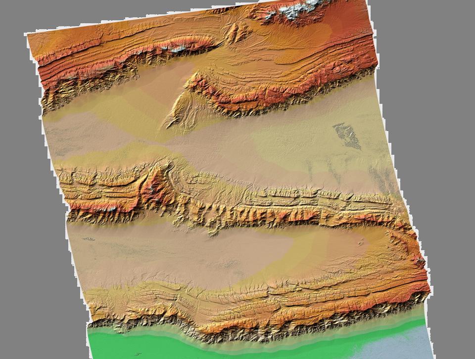
6 Madagascar :55:44 (DT 11)
7 TanDEM-X Commissioning Phase June 10 July 10 Aug 10 Sep 10 Oct 10 Nov 10 Dec 10 Launch 21 June TDX Orbit Drift km 20 km 20 km Formation Early Orbit Phase First SAR Image 24 June (MET +3.6) 6 Month Commissioning Phase Grg Segment Checkout First DEM 16 July (MET +25) TDX Monostatic Comm. Phase First bi-static SAR image 8 August (MET +48) Page 7
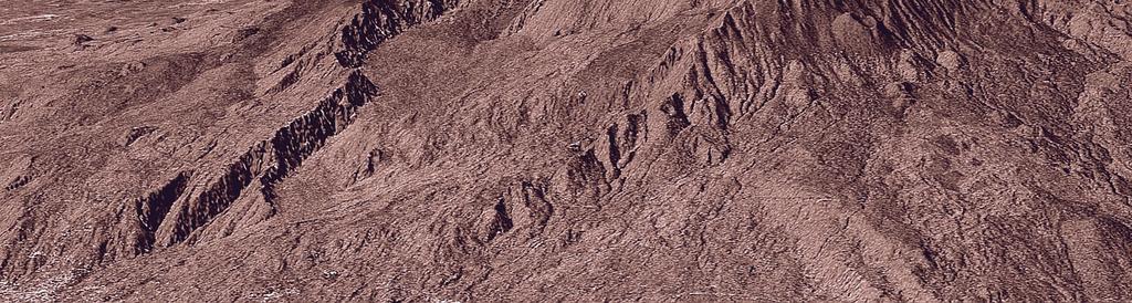
8 Tien Shan, China T12:39:09


9 Drygalski Glacier, Antarctica T23:40:49
10 Geometric and Radiometric Cross Check TSX vs. TDX TSX-1 Delta Range [m] 1,5 1,25 1 0,75 0,5 0,25 0-0,25-0,5-0, ,25 TSX Geometric Calibration 2010 Geometric Offset in Range 10,01 = nsec / cm = 1.90 nsec / cm s003 s009 s005 s012 Asc Des Offset s016 s023 s026 s019 8,34 6,68 5,00 3,34 1,67 0,00-1,67-3,34-5,00-6,68-8,34-1,5-10, Look Angle [deg] Delta Instrument Delay [ nsec] Geometric Cross Offset TSX TDX TSX-1 TDX-1 = - 80 psec rg TSX-1 TDX-1 = cm ~ 1/3 Wavelength! Delta Range [m] TDX-1 1,5 1,25 1 0,75 0,5 0,25 0-0,25-0,5-0, ,25 s003 TDX Geometric Calibration Annotated Instrument Delay [ nsec ] Geometric Offset in Range 10,01 Asc 8,34 Des 6,68 Offset 5,00 3,34 1,67 0,00 s009 s016 s023-1,67 s005-3,34 s012 s019 s026-5,00-6,68-8,34 = nsec / cm = 2.03 nsec / cm -1,5-10, Look Angle [deg] Radiometric Cross Offset TSX TDX cross ~ db Delta Instrument Delay [ nsec] [db] grass TDX urban TDX grass TSX urban TSX mean TDX mean TSX TDX = db Grass TDX = db = db Grass TSX = db = db 0 of Distributed Targets X X Grass Area X X Urban Urban TDX = db = db Urban TSX = db = db TSX = db Page 10
11 Comparison TDX versus TSX TSX TDX Internal Calibration Instrument Drift (Ampl./Phase) 0.15dB / 0.5 deg 0.1dB / 0.85 deg TRM-Charact. (Ampl./Phase) < 0.2 db / < 2 deg < 0.2 db / < 2 deg Geometric Calibration Pixel Localisation Accuracy (az/rg) 48.3 cm / 28.5 cm 49.9 cm / 30.4 cm Antenna Pointing Azimuth / Elevation 1 mdeg / 4 mdeg < 2 mdeg / < 2 mdeg Antenna Model Shape and Gain-Offset ±0.2 db ±0.2 db Radiometric Calibration Radiometric Stability 0.15 db / (2 years) 0.15 db / (2 years) Rel. Rad. Accuracy (Strip/Scan) 0.16 db / 0.27 db 0.2 db / 0.3 db Abs. Rad. Accuracy (Strip/Scan) 0.34 db / 0.40 db 0.48 db / 0.52 db Page 11
 48.3 cm / 28.5 cm 49.9 cm / 30.")
12 Comparison TDX versus TSX TSX TDX Internal Calibration Instrument Drift (Ampl./Phase) 0.15dB / 0.5 deg 0.1dB / 0.85 deg TRM-Charact. (Ampl./Phase) < 0.2 db / < 2 deg < 0.2 db / < 2 deg Perfect Twins Geometric Calibration Pixel Localisation Accuracy (az/rg) 48.3 cm / 28.5 cm 49.9 cm / 30.4 cm Antenna Pointing Azimuth / Elevation 1 mdeg / 4 mdeg < 2 mdeg / < 2 mdeg Antenna Model TSX TDX Shape and Gain-Offset ±0.2 db ±0.2 db Radiometric Calibration Radiometric Stability 0.15 db / (2 years) 0.15 db / (2 years) Rel. Rad. Accuracy (Strip/Scan) 0.16 db / 0.27 db 0.2 db / 0.3 db Abs. Rad. Accuracy (Strip/Scan) 0.34 db / 0.40 db 0.48 db / 0.52 db Page 12

13 14 October 2010: Close Formation Flight Slide 13
14 TanDEM-X Commissioning Phase June 10 July 10 Aug 10 Sep 10 Oct 10 Nov 10 Dec 10 Launch 21 June TDX Orbit Drift km 20 km 20 km Formation Close Helix-Formation m Early Orbit Phase First SAR Image 24 June (MET +3.6) 6 Months Commissioning Phase Grg Segment Checkout First DEM 16 July (MET +25) TDX Monostatic Comm. Phase First bi-static SAR image 8 August (MET +48) Bi-static Commissioning Phase First close formation DEM 19 October (MET +124) Slide 14

15 Mt. Etna


16 Exclusion Zones HELIX HELIX TDX TSX-1 TSX may not transmit in asc. orbit TSX DEM exclusion zones (example) 30 0 TDX-1 DEM TSX-1 TDX-1 possible beams & side-lobes standard TSX beams + PN-Gating beams TDX may not transmit in desc. orbit For each satellite and looking mode, an Exclusion Zone is defined Exclusion Zone: argument of latitude region, where SAR transmissions have to be suppressed Slide 16

17 Bi-static Operation - Synchronisation Bi-static operation of TSX and TDX requires synchronisation of independent oscillators Phase referencing by exchange of pulses via synchronization link Leap PRIs compensate drift of Echo Window Sync Warning for mutual health check Slide 17
18 TanDEM-X Commissioning Phase June 10 July 10 Aug 10 Sep 10 Oct 10 Nov 10 Dec 10 Launch 21 June TDX Orbit Drift km 20 km 20 km Formation Close Helix-Formation m Early Orbit Phase First SAR Image 24 June (MET +3.6) 6 Months Commissioning Phase Grg Segment Checkout First DEM 16 July (MET +25) TDX Monostatic Comm. Phase First bi-static SAR image 8 August (MET +48) Bi-static Commissioning Phase First close formation DEM 19 October (MET +124) DEM Acquisition Slide 18
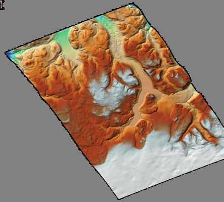

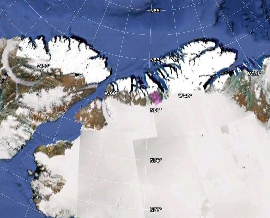
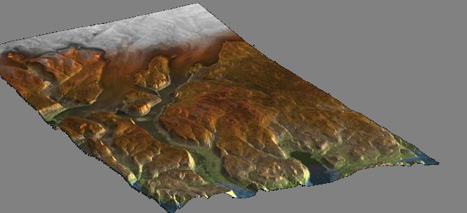

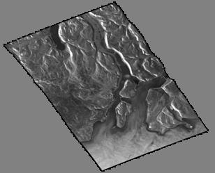
19 1 st (available) operational DEM Acquisition from Dec 12th ( Northern Greenland, HoA 53m ) Slide 19
20 TanDEM-X Mission Status Commissioning phase finished according to plan (more than 8000 DTs) Goal to start global DEM acquisition achieved Performance and calibration of the individual satellites within specification or better perfect twins Stable operations in close formation TSX & TDX and the combined TerraSAR-X/TanDEM-X Ground Segment are performing remarkably well Calibration of the bi-static synchronisation system ongoing Slide 20
TanDEM-X SAR System Verification
 TanDEM-X SAR System Verification Mathias Weigt, Ulrich Steinbrecher, Thomas Kraus, Johannes Böer, Benjamin Bräutigam 07-09 November 2011 Overview Monostatic Commissioning Phase Verification of Power/Thermal
TerraSAR-X Calibration Status 2 Years in Flight
 2 Years in Flight Dirk Schrank, Marco Schwerdt, Markus Bachmann, Björn Döring, Clemens Schulz November 2009 CEOS 09 VG 1 Calibration Tasks Performed 2009 Introduction Challenge Schedule Re-Calibration
Commissioning the TanDEM-X Ground Segment An Interim Commissioning Phase Perspective
 Commissioning the TanDEM-X Ground Segment An Interim Commissioning Phase Perspective B. Schättler, R. Kahle, R. Metzig, T. Fritz, U. Steinbrecher, M. Wermuth, M. Zink, and TanDEM-X Ground Segment Team
7.7.2 TerraSAR-X-Add-on for Digital Elevation Measurements
 7.7.2 TerraSAR-X-Add-on for Digital Elevation Measurements TDX launched on June 21, 2010 18 Overview of the TanDEM-X overall system architecture (image credit: DLR) Figure 10: Overview of the TanDEM-X
TanDEM-X: Mission Status & Scientific Contribution
 TanDEM-X: Mission Status & Scientific Contribution Irena Hajnsek 1/2, Gerhard Krieger 1, Kostas Papathanassiou 1, Stefan Baumgartner 1, Marc Rodriguez-Cassola 1, Pau Prats 1, Maria Sanjuan Ferrer 1, Florian
Polarisation Capabilities and Status of TerraSAR-X
 Polarisation Capabilities and Status of TerraSAR-X Irena Hajnsek, Josef Mittermayer, Stefan Buckreuss, Kostas Papathanassiou German Aerospace Center Microwaves and Radar Institute irena.hajnsek@dlr.de
Automation challenges of the Mission Planning System and the Ground Station Network within the TerraSAR-X/TanDEM-X Ground Segment
 DLR.de Chart 1 Automation challenges of the Mission Planning System and the Ground Station Network within the TerraSAR-X/TanDEM-X Ground Segment F. Mrowka, R. Metzig, B. Schättler, R. Kahle, C. Lenzen,
Motion Detection Using TanDEM-X Along-Track Interferometry
 Motion Detection Using TanDEM-X Along-Track Interferometry Steffen Suchandt and Hartmut Runge German Aerospace Center, Remote Sensing Technology Institute TanDEM-X Science Meeting, June 12th, 2013 Outline
Final Results of the Efficient TerraSAR-X Calibration Method
 Final Results of the Efficient TerraSAR-X Calibration Method M. Schwerdt, B. Bräutigam, M. Bachmann, B. Döring, Dirk Schrank and Jaime Hueso Gonzalez Microwave and Radar Institute of the German Aerospace
GMES Sentinel-1 Transponder Development
 GMES Sentinel-1 Transponder Development Paul Snoeij Evert Attema Björn Rommen Nicolas Floury Malcolm Davidson ESA/ESTEC, European Space Agency, Noordwijk, The Netherlands Outline 1. GMES Sentinel-1 overview
TerraSAR-X Mission: Application and Data Access
 TerraSAR-X Mission: Application and Data Access Irena Hajnsek & TSX TEAM German Aerospace Center Microwaves and Radar Institute Pol-InSAR Research Group 2 years in Orbit (since June 2007) irena.hajnsek@dlr.de
Calibration Concepts for Future Low Frequency SAR Systems. Jens Reimann, Marco Schwerdt, Sravan Kumar Aitha and Manfred Zink
 Calibration Concepts for Future Low Frequency SAR Systems Jens Reimann, Marco Schwerdt, Sravan Kumar Aitha and Manfred Zink DLR.de Chart 2 Low Frequency SAR Missions OHB DLR.de Chart 3 BIOMASS - Facts
7.7 TerraSAR-X & TanDEM-X
 7.7 TerraSAR-X & TanDEM-X Two Innovative Remote Sensing Stars for space-borne Earth Observation Vorlesung Wolfgang Keydel Microwaves and Radar Institute, German Aerospace Research Center (DLR), D-82230
TerraSAR-X/TanDEM-X Mission Planning. Handling Satellites in Close Formation. Dr. Michael P. Geyer, Dr. Falk Mrowka, Christoph Lenzen
 TerraSAR-X/TanDEM-X Mission Planning Handling Satellites in Close Formation Dr. Michael P. Geyer, Dr. Falk Mrowka, Christoph Lenzen German Space Operations Center, DLR Oberpfaffenhofen, 82234 Wessling,
TanDEM-X. 1. Mission Overview. Science Meeting No SAR Imaging Modes & Performance 3. Satellite Design Overview 4. Launcher 5.
 TanDEM-X Science Meeting No. 1 Dresden 15.5.2006 Wolfgang Pitz EADS Astrium GmbH D-88039 Friedrichshafen 1. Mission Overview 2. SAR Imaging Modes & Performance 3. Satellite Design Overview 4. Launcher
ERS-2 SAR CYCLIC REPORT
 ERS-2 SAR CYCLIC REPORT C YCLE 90 24-November-2003-29-December-2003 Prepared by: PCS SAR TEAM Issue: 1.0 Reference: Date of Issue Status: Document type: Technical Note Approved by: T A B L E L E O F C
KONGSBERG SATELLITE SERVICES 2017 Line Steinbakk, Director Programs. Himmel og hav - Ålesund 3. Oktober 2017
 KONGSBERG SATELLITE SERVICES 2017 Line Steinbakk, Director Programs Himmel og hav - Ålesund 3. Oktober 2017 KSAT HQ IN TROMSØ 69N Established in 1967 Kongsberg Satellite Services since 2002 World leading
Interferometric Cartwheel 1
 The Interferometric CartWheel A wheel of passive radar microsatellites for upgrading existing SAR projects D. Massonnet, P. Ultré-Guérard (DPI/EOT) E. Thouvenot (DTS/AE/INS/IR) Interferometric Cartwheel
ERS-2 SAR CYCLIC REPORT
 ERS-2 SAR CYCLIC REPORT C YCLE 96 22-JUN-2004 to 27-JUL-2004 Orbit 47951 to 48452 Prepared by: PCS SAR TEAM Issue: 1.0 Reference: Date of Issue Status: Document type: Technical Note Approved by: T A B
Exploring the Potential Pol-InSAR Techniques at X-Band: First Results & Experiments from TanDEM-X
 Exploring the Potential Pol-InSAR Techniques at X-Band: First Results & Experiments from TanDEM-X K. Papathanassiou, F. Kugler, J-S. Kim, S-K. Lee, I. Hajnsek Microwaves and Radar Institute (DLR-HR) German
SAOCOM Calibration Strategy
 COMISION NACIONAL DE ACTIVIDADES ESPACIALES (The Argentinean National Commission of Space Activities) M. Azcueta, J. Giardini, J. P. Cuesta González, M. Thibeault, T. Zajc November 7-9, 20 October 20 8
RADARSAT-1: An End-of-Mission Review of the Imaging and Calibration Performance of a Magnificent Canadian Instrument
 RADARSAT-1: An End-of-Mission Review of the Imaging and Calibration Performance of a Magnificent Canadian Instrument S. Cote, S. Srivastava Canadian Space Agency S. Muir Calian Technologies Ltd 1 RADARSAT-1
ENVISAT ASAR MONTHLY REPORT MARCH 2012
 ENVISAT ASAR MONTHLY REPORT MARCH 2012 PUBLIC SUMMARY prepared by/préparé par IDEAS SAR Team reference/réference ENVI-CLVL-EOPG-TN-04-0009 issue/édition 73 revision/révision 0 date of issue/date d édition
ERS-2 SAR CYCLIC REPORT
 ERS-2 SAR CYCLIC REPORT C YCLE 101 14-DEC-2004 to 18-JAN-2005 Orbit 50456 to 50957 Prepared by: PCS SAR TEAM Issue: 1.0 Reference: Date of Issue Status: Document type: Technical Note Approved by: T A B
KOMPSAT-5 Image Quality Measurement in 2017
 Korea Aerospace Research Institute Program Office 169-84 Gwahangno Yuseong-gu Daejeon, 305-806, Korea Image Quality Measurement in 2017 08 Nov 2017 Korea Aerospace Research Institute Horyung Jeong, Donghyun
Report on CEOS WGCV SAR Subgroup Activities
 Report on CEOS WGCV SAR Subgroup Activities CEOS WGCV 37 th Plenary ESRIN, Frascati/Italy February 17-20, 2014 M. Zink Chair CEOS WGCV SAR Subgroup German Aerospace Center (DLR) manfred.zink@dlr.de http://sarcv.ceos.org
PAZ Product Definition
 PAZ Product Definition CALVAL Centre Juan Manuel Cuerda Muñoz, Javier del Castillo Mena, Adolfo López Pescador, Nuria Gimeno Martínez, Nuria Casal Vázquez, Patricia Cifuentes Revenga, Marcos García Rodríguez,
European Space Agency and IPY
 European Space Agency and IPY ESA supports IPY 2007-2008 activities: First ESA step was a dedicated Announcement Opportunity (AO) for EO data provision in support IPY, released in 2006, with data provision
Nadir Margins in TerraSAR-X Timing Commanding
 CEOS SAR Calibration and Validation Workshop 2008 1 Nadir Margins in TerraSAR-X Timing Commanding S. Wollstadt and J. Mittermayer, Member, IEEE Abstract This paper presents an analysis and discussion of
TerraSAR-X Calibration Ground Equipment
 86 Proceedings of WFMN07, Chemnitz, Germany TerraSAR-X Calibration Ground Equipment Björn J. Döring, Marco Schwerdt, Robert Bauer Microwaves and Radar Institute German Aerospace Center (DLR) Oberpfaffenhofen,
PROGRESS IN ICESHEET MONITORING USING SENTINEL SATELLITES
 Polar Space Task Group PROGRESS IN ICESHEET MONITORING USING SENTINEL SATELLITES Thomas Nagler, Helmut Rott, Markus Hetzenecker, Jan Wuite / ENVEO Contributions by Dana Floricioiu / DLR Anders Kusk / DTU
Sentinel-1A Tile #11 Failure
 MPC-S1 Reference: Nomenclature: MPC-0324 OI-MPC-ACR Issue: 1. 2 Date: 2016,Oct.13 FORM-NT-GB-10-1 MPC-0324 OI-MPC-ACR V1.2 2016,Oct.13 i.1 Chronology Issues: Issue: Date: Reason for change: Author 1.0
MULTI-CHANNEL SAR EXPERIMENTS FROM THE SPACE AND FROM GROUND: POTENTIAL EVOLUTION OF PRESENT GENERATION SPACEBORNE SAR
 3 nd International Workshop on Science and Applications of SAR Polarimetry and Polarimetric Interferometry POLinSAR 2007 January 25, 2007 ESA/ESRIN Frascati, Italy MULTI-CHANNEL SAR EXPERIMENTS FROM THE
Biomass, a polarimetric interferometric P-band SAR mission
 Biomass, a polarimetric interferometric P-band SAR mission M. Arcioni, P. Bensi, M. Fehringer, F. Fois, F. Heliere, N. Miranda, K. Scipal Fringe 2015, ESRIN 27/03/2015 The Biomass Mission 1. Biomass was
Session I: Status Reports on Ongoing and Future Missions Chairs: M.Shimada (JAXA) and P. Snoeij (ESA)
 and P. Snoeij (ESA)") Session I: Status Reports on Ongoing and Future Missions Chairs: M.Shimada (JAXA) and P. Snoeij (ESA) Canadian Radarsat Mission status-s. Cote Operating far beyond design lifetime (RSAT-1: 16 years, ASAR:
Session I: Status Reports on Ongoing and Future Missions Chairs: M.Shimada (JAXA) and P. Snoeij (ESA) Canadian Radarsat Mission status-s. Cote Operating far beyond design lifetime (RSAT-1: 16 years, ASAR:
ERS-2 SAR CYCLIC REPORT
 28TH SEPTEMBER 2009-2ND NOVEMBER 2009 (CYCLE 151) PUBLIC SUMMARY prepared by/préparé par IDEAS SAR Team reference/réference IDEAS-BAE-OQC-REP-0245 issue/édition 9 revision/révision 0 date of issue/date
Concept of the future L-band SAR mission for wide swath SAR observation
 Concept of the future SAR mission for wide swath SAR observation A.Karasawa 1, Y.Okada 1, Y.Yokota 1, S.Nakamura 1 1) Mitsubishi Electric Corporation 1 Outline 1:Development of SAR systems in MELCO 2:Development
Formation Flying Slide 2 ION Alberta Chapter > Calgary > 20 Dec 2012
 Formation Flying Slide 2 ION Alberta Chapter > Calgary > 20 Dec 2012 PRISMA (SSC) (SSC) Swedish technology demonstration mission Two micro-satellites (MANGO, TANGO) Qualification of sensors (GPS, FFRF,
Status of MOLI development MOLI (Multi-footprint Observation Lidar and Imager)
") Status of MOLI development MOLI (Multi-footprint Observation Lidar and Imager) Tadashi IMAI, Daisuke SAKAIZAWA, Jumpei MUROOKA and Toshiyoshi KIMURA JAXA 1 Outline of This Presentation 1. Overview of MOLI
Status of MOLI development MOLI (Multi-footprint Observation Lidar and Imager) Tadashi IMAI, Daisuke SAKAIZAWA, Jumpei MUROOKA and Toshiyoshi KIMURA JAXA 1 Outline of This Presentation 1. Overview of MOLI
Detection of traffic congestion in airborne SAR imagery
 Detection of traffic congestion in airborne SAR imagery Gintautas Palubinskas and Hartmut Runge German Aerospace Center DLR Remote Sensing Technology Institute Oberpfaffenhofen, 82234 Wessling, Germany
PALSAR SCANSAR SCANSAR Interferometry
 PALSAR SCANSAR SCANSAR Interferometry Masanobu Shimada Japan Aerospace Exploration Agency Earth Observation Research Center ALOS PI symposium, Greece Nov. 6 2008 1 Introduction L-band PALSAR strip mode
Relative Navigation, Timing & Data. Communications for CubeSat Clusters. Nestor Voronka, Tyrel Newton
 Relative Navigation, Timing & Data Communications for CubeSat Clusters Nestor Voronka, Tyrel Newton Tethers Unlimited, Inc. 11711 N. Creek Pkwy S., Suite D113 Bothell, WA 98011 425-486-0100x678 voronka@tethers.com
The Biomass Mission, status of the satellite system
 The Biomass Mission, status of the satellite system M. Arcioni, P. Bensi, M. Fehringer, F. Fois, F. Heliere, K. Scipal PolInSAR/Biomass Meeting 2015, ESRIN 29/01/2015 1. Key facts (lifetime, duty cycle
Consideration of Inter-Pulse and Intra-Pulse Satellite Motion in Zero Doppler SAR Processing
 DLR.de Chart 1 Consideration of Inter-Pulse and Intra-Pulse Satellite Motion in Zero Doppler SAR Processing Ulrich Balss, Helko Breit, Michael Eineder Remote Sensing Technology Institute (IMF) German Aerospace
TerraSAR-X & TanDEM-X
 TerraSAR-X & TanDEM-X David Miller DLR - Raumfahrt-Industrietage in Friedrichshafen 13./14. Mai 2009 Missions Overview TerraSAR-X & TanDEM-X Satellites with X-Band (9.65GHz) Synthetic Aperture Radar using
GPS: The Basics. Darrell R. Dean, Jr. Civil and Environmental Engineering West Virginia University. Expected Learning Outcomes for GPS
 GPS: The Basics Darrell R. Dean, Jr. Civil and Environmental Engineering West Virginia University Expected Learning Outcomes for GPS Explain the acronym GPS Name 3 important tdt dates in history of GPS
Sub-system and System Level Testing and Calibration of Space Altimeters and LIDARS.
 Sub-system and System Level Testing and Calibration of Space Altimeters and LIDARS. Haris Riris, Pete Liiva, Xiaoli Sun, James Abshire Laser Remote Sensing Branch Goddard Space Flight Center, Greenbelt,
FIRST DATA ACQUISITION AND PROCESSING CONCEPTS FOR THE TANDEM-X MISSION
 FIRST DATA ACQUISITION AND PROCESSING CONCEPTS FOR THE TANDEM-X MISSION M. Eineder, G. Krieger, A. Roth German Aerospace Center DLR 82234 Wessling, Oberpfaffenhofen, Germany KEY WORDS: Earth Observation,
TANDEM-X MISSION STATUS
 TANDEM-X MISSION STATUS M. Zink DLR, Microwaves and Radar Institute, 82234 Wessling, Germany manfred.zink@dlr.de Commission VI, WG VI/4 KEY WORDS: TanDEM-X, bistatic SAR formation, SAR interferometry,
Contribution of Sentinel-1 data for the monitoring of seasonal variations of the vegetation
 Contribution of Sentinel-1 data for the monitoring of seasonal variations of the vegetation P.-L. Frison, S. Kmiha, B. Fruneau, K. Soudani, E. Dufrêne, T. Koleck, L. Villard, M. Lepage, J.-F. Dejoux, J.-P.
KOMPSAT Constellation. November 2012 Satrec Initiative
 KOMPSAT Constellation November 2012 Satrec Initiative KOMPSAT Constellation KOMPSAT National program Developed and operated by KARI (Korea Aerospace Research Institute) Dual use : Government & commercial
Aaron J. Dando Principle Supervisor: Werner Enderle
 Aaron J. Dando Principle Supervisor: Werner Enderle Australian Cooperative Research Centre for Satellite Systems (CRCSS) at the Queensland University of Technology (QUT) Aaron Dando, CRCSS/QUT, 19 th AIAA/USU
TanDEM-X: Mission Performance and Product Definition
 TanDEM-X: Mission Perforance and Product Definition Gerhard Krieger First TanDEM-X Science Tea Meeting 15-May-2006, Dresden Capabilities of TanDEM-X Cross-Track Interferoetry Along-Track Interferoetry
Bistatic Radar Receiver for CubeSats: The RAX Payload
 Bistatic Radar Receiver for CubeSats: The RAX Payload John Buonocore Hasan Bahcivan SRI International 7 th Annual CubeSat Developer s Workshop 22 April 2010 Cal Poly San Luis Obispo SRI Proprietary RAX
Spaceborne Active Phased Array Antenna Calibration Using an Accurate Antenna Model
 Spaceborne Active Phased Array Antenna Calibration Using an Accurate Antenna Model Markus Bachmann, Marco Schwerdt, Benjamin Bräutigam German Aerospace Center (DLR), Oberpfaffenhofen, 82234 Wessling, Germany,
THE NASA/JPL AIRBORNE SYNTHETIC APERTURE RADAR SYSTEM. Yunling Lou, Yunjin Kim, and Jakob van Zyl
 THE NASA/JPL AIRBORNE SYNTHETIC APERTURE RADAR SYSTEM Yunling Lou, Yunjin Kim, and Jakob van Zyl Jet Propulsion Laboratory California Institute of Technology 4800 Oak Grove Drive, MS 300-243 Pasadena,
Sentinel-1 System Overview
 Sentinel-1 System Overview Dirk Geudtner, Rámon Torres, Paul Snoeij, Malcolm Davidson European Space Agency, ESTEC Global Monitoring for Environment and Security (GMES) EU-led program aiming at providing
Hawk Institute for Space Sciences. Firefly Comms Plan. November 30, 2009
 Hawk Institute for Space Sciences Firefly Comms Plan November 30, 2009 Firefly Operational View UMES POCC Pocomoke City Science Team Ground Station e.g. WFF Internet 2 Comms Plan Overview MicroHard MHX-425
PAZ Mission CalVal Centre
 PAZ Mission CalVal Centre In-Flight Campaigns Design CASAL, N., CIFUENTES, P., CUERDA, J.M., DEL CASTILLO, J., CORES, J.F., GARCIA, M., GIMENO N., GOMEZ, B., GONZALEZ, M.J., LOPEZ, A. 30/10/2015 Pag.:
Adaptive SAR Results with the LiMIT Testbed
 Adaptive SAR Results with the LiMIT Testbed Gerald Benitz Adaptive Sensor Array Processing Workshop 7 June 2005 999999-1 Outline LiMIT collection platform SAR sidelobe recovery Electronic Protection (EP)
Current and Future Meteorological Satellite Program of China
 Current and Future Meteorological Satellite Program of China ZHANG Wenjian, DONG Chaohua XU Jianmin, YANG Jun China Meteorological Administration May 30, 2005 Beijing, CHINA Outline of the Presentation
Ocean SAR altimetry. from SIRAL2 on CryoSat2 to Poseidon-4 on Jason-CS
 Ocean SAR altimetry from SIRAL2 on CryoSat2 to Poseidon-4 on Jason-CS Template reference : 100181670S-EN L. Phalippou, F. Demeestere SAR Altimetry EGM NOC, Southampton, 26 June 2013 History of SAR altimetry
Principles of Remote Sensing. Shuttle Radar Topography Mission S R T M. Michiel Damen. Dept. Earth Systems Analysis
 Principles of Remote Sensing Shuttle Radar Topography Mission S R T M Michiel Damen Dept. Earth Systems Analysis Contents Present problems with DEMs Advantage of SRTM Cell size Mission and system Radar
EVALUATION OF PLEIADES-1A TRIPLET ON TRENTO TESTFIELD
 EVALUATION OF PLEIADES-1A TRIPLET ON TRENTO TESTFIELD D. Poli a, F. Remondino b, E. Angiuli c, G. Agugiaro b a Terra Messflug GmbH, Austria b 3D Optical Metrology Unit, Fondazione Bruno Kessler, Trento,
HEMERA Constellation of passive SAR-based micro-satellites for a Master/Slave configuration
 HEMERA Constellation of passive SAR-based micro-satellites for a Master/Slave HEMERA Team Members: Andrea Bellome, Giulia Broggi, Luca Collettini, Davide Di Ienno, Edoardo Fornari, Leandro Lucchese, Andrea
Wind Turbine Analysis for. Cape Cod Air Force Station Early Warning Radar. and Beale Air Force Base Upgraded Early Warning Radar.
 Wind Turbine Analysis for Cape Cod Air Force Station Early Warning Radar and Beale Air Force Base Upgraded Early Warning Radar Spring 2007 EXECUTIVE SUMMARY The Missile Defense Agency (MDA) analyzed the
SMAP Overview. Ron Weaver Slides li0ed from Barry Weiss and Jennifer Cruz at JPL Barry Weiss. Jet Propulsion Laboratory
 http://smap.jpl.nasa.gov/ SMAP Overview Ron Weaver Slides li0ed from Barry Weiss and Jennifer Cruz at JPL Barry Weiss Jet Propulsion Laboratory California Ins7tute of Technology Pasadena, CA Copyright
Vertical or horizontal antenna for limited space
 Vertical or horizontal antenna for limited space If you have very limited space for a DX antenna, you may consider vertical, because it has low angle of radiation. But vertical polarization involves high
VERY PRECISE SYNCHRONIZATION OF A GROUP OF PSEUDOLITES
 VERY PRECISE SYNCHRONIZATION OF A GROUP OF PSEUDOLITES Werner R. Lange Lange-Electronic GmbH Gernlinden, Germany T.: +49-8142-2845820 WLange@lange-electronic.de Abstract Pseudolites are GNSS transmitters
The TerraSAR-L System and Mission Objectives
 The TerraSAR-L System and Mission Objectives Manfred Zink & Ramon Torres TerraSAR Project, ESA-ESTEC Keplerlaan 1, 2200 AG, Noordwijk, The Netherlands Tel: +31 71565 3038, Fax: +31 71565 3191, Email: Manfred.Zink@esa.int
DLR contribution and perspectives for JECAM
 DLR contribution and perspectives for JECAM Dr. Helmut Staudenrausch 1, Dr. Achim Roth 2 1 DLR Space Administration, Earth Observations helmut.staudenrausch@dlr.de 2 DLR, German Remote Sensing Data Center
CDAAC Ionospheric Products
 CDAAC Ionospheric Products Stig Syndergaard COSMIC Project Office COSMIC retreat, Oct 13 14, 5 COSMIC Ionospheric Measurements GPS receiver: { Total Electron Content (TEC) to all GPS satellites in view
ROLE OF SATELLITE DATA APPLICATION IN CADASTRAL MAP AND DIGITIZATION OF LAND RECORDS DR.T. RAVISANKAR GROUP HEAD (LRUMG) RSAA/NRSC/ISRO /DOS HYDERABAD
 RSAA/NRSC/ISRO /DOS HYDERABAD") ROLE OF SATELLITE DATA APPLICATION IN CADASTRAL MAP AND DIGITIZATION OF LAND RECORDS DR.T. RAVISANKAR GROUP HEAD (LRUMG) RSAA/NRSC/ISRO /DOS HYDERABAD WORKSHOP on Best Practices under National Land Records
ROLE OF SATELLITE DATA APPLICATION IN CADASTRAL MAP AND DIGITIZATION OF LAND RECORDS DR.T. RAVISANKAR GROUP HEAD (LRUMG) RSAA/NRSC/ISRO /DOS HYDERABAD WORKSHOP on Best Practices under National Land Records
Sub-Mesoscale Imaging of the Ionosphere with SMAP
 Sub-Mesoscale Imaging of the Ionosphere with SMAP Tony Freeman Xiaoqing Pi Xiaoyan Zhou CEOS Workshop, ASF, Fairbanks, Alaska, December 2009 1 Soil Moisture Active-Passive (SMAP) Overview Baseline Mission
SMOS Payload Performance
 SMOS Payload Performance Manuel Martin-Neira, Michael Brown SM-OS Project European Space Agency Josep Closa EADS-CASA Espacio and contributions from: UPC and DEIMOS SMOS project teams 1/33 Contents: -
Worst-Case GPS Constellation for Testing Navigation at Geosynchronous Orbit for GOES-R
 Worst-Case GPS Constellation for Testing Navigation at Geosynchronous Orbit for GOES-R Kristin Larson, Dave Gaylor, and Stephen Winkler Emergent Space Technologies and Lockheed Martin Space Systems 36
Earth Observation and Sensing Technologies: a focus on Radar Imaging Developments. Riccardo Lanari
 Earth Observation and Sensing Technologies: a focus on Radar Imaging Developments Riccardo Lanari Institute for Electromagnetic Sensing of the Environment (IREA) National Research Council of Italy (CNR)
COSMO-skymed, TerraSAR-X, and RADARSAT-2 geolocation accuracy after compensation for earth-system effects
 Zurich Open Repository and Archive University of Zurich Main Library Strickhofstrasse 9 CH-857 Zurich www.zora.uzh.ch Year: COSMO-skymed, TerraSAR-X, and RADARSAT- geolocation accuracy after compensation
SAR Interferometry Capabilities of Canada's planned SAR Satellite Constellation
 SAR Interferometry Capabilities of Canada's planned SAR Satellite Constellation Dirk Geudtner, Guy Séguin,, Ralph Girard Canadian Space Agency RADARSAT Follow-on Program CSA is in the middle of a Phase
Fundamental Concepts of Radar
 Fundamental Concepts of Radar Dr Clive Alabaster & Dr Evan Hughes White Horse Radar Limited Contents Basic concepts of radar Detection Performance Target parameters measurable by a radar Primary/secondary
Radar and Satellite Remote Sensing. Chris Allen, Associate Director Technology Center for Remote Sensing of Ice Sheets The University of Kansas
 Radar and Satellite Remote Sensing Chris Allen, Associate Director Technology Center for Remote Sensing of Ice Sheets The University of Kansas 2of 43 Outline Background ice sheet characterization Radar
Point-to-Multipoint Coexistence with C-band FSS. March 27th, 2018
 Point-to-Multipoint Coexistence with C-band FSS March 27th, 2018 1 Conclusions 3700-4200 MHz point-to-multipoint (P2MP) systems could immediately provide gigabit-class broadband service to tens of millions
The Current Status and Brief Results of Engineering Model for PALSAR-2 onboard ALOS-2 and Science Project
 The Current Status and Brief Results of Engineering Model for PALSAR-2 onboard ALOS-2 and Science Project + The 16 th KC meeting Japan Aerospace Exploration Agency Masanobu Shimada, Yukihiro KANKAKU The
RECOMMENDATION ITU-R S.1257
 Rec. ITU-R S.157 1 RECOMMENDATION ITU-R S.157 ANALYTICAL METHOD TO CALCULATE VISIBILITY STATISTICS FOR NON-GEOSTATIONARY SATELLITE ORBIT SATELLITES AS SEEN FROM A POINT ON THE EARTH S SURFACE (Questions
Proba-V QWG#7 Flight & GS status. 3 4 May 2018 ACRI, Sophia-Antipolis
 Proba-V QWG#7 Flight & GS status 3 4 May 2018 ACRI, Sophia-Antipolis Orbit status Slide 2 Orbit status LTDN evolution: 7 May 2013: 10:44:30 1 Dec. 2014: 10:51:08 26 Apr. 2017: 10:36:26 Oct 2017: 10:30
The Sentinel-1 Constellation
 The Sentinel-1 Constellation Evert Attema, Sentinel-1 Mission & System Manager AGRISAR and EAGLE Campaigns Final Workshop 15-16 October 2007 ESA/ESTECNoordwijk, The Netherlands Sentinel-1 Programme Sentinel-1
Correct Measurement of Timing and Synchronisation Signals - A Comprehensive Guide
 Correct Measurement of Timing and Synchronisation Signals - A Comprehensive Guide Introduction This document introduces the fundamental aspects of making valid timing and synchronisation measurements and
KONGSBERG SATELLITE SERVICES Earth Observation for Maritime Operations Current Capabilities and Future Potential
 KONGSBERG SATELLITE SERVICES 2017 Earth Observation for Maritime Operations Current Capabilities and Future Potential Andreas Hay Kaljord Project Manager KSAT HQ IN TROMSØ - 69N WELCOME TO TROMSØ Established
RAX: The Radio Aurora explorer
 RAX: Matt Bennett University of Michigan CubeSat Workshop Cal Poly, San Luis Obispo April 22 nd, 2009 Background Sponsored by National Science Foundation University of Michigan and SRI International Collaboration
Global 25 m Resolution PALSAR-2/PALSAR Mosaic. and Forest/Non-Forest Map (FNF) Dataset Description
 Dataset Description") Global 25 m Resolution PALSAR-2/PALSAR Mosaic and Forest/Non-Forest Map (FNF) Dataset Description Japan Aerospace Exploration Agency (JAXA) Earth Observation Research Center (EORC) 1 Revision history Version
Global 25 m Resolution PALSAR-2/PALSAR Mosaic and Forest/Non-Forest Map (FNF) Dataset Description Japan Aerospace Exploration Agency (JAXA) Earth Observation Research Center (EORC) 1 Revision history Version
SAR missions for oceanography at the European Space Agency
 SAR missions for oceanography at the European Space Agency ERS-1, ERS-2, Envisat, Sentinel-1A, Sentinel-1B, ESA 3 rd Party Missions (ALOS) Prepared by ESA teams and ESA supporting companies ESA and SAR
IASI on METOP On-Ground Calibration of the FM2 Instrument
 Infrared Atmospheric Sounding Interferometer IASI on METOP On-Ground Calibration of the FM2 Instrument International TOVS Study Conference 25-31, May 2005 Beijing China D. Blumstein 1,B.Tournier 2, T.Carlier
China. France Oceanography S A T. Overview of the near-real time wave products of the CFOSAT mission. e l l i t e
 China Overview of the near-real time wave products of the CFOSAT mission C. Tison (1), D. Hauser (2), S. Guibert (1), T. Amiot (1), L. Aouf (3), J.M. Lefèvre (3), B. Chapron (5), N. Corcoral (1), P. Castillan
Space Frequency Coordination Group
 Space Frequency Coordination Group Report SFCG 38-1 POTENTIAL RFI TO EESS (ACTIVE) CLOUD PROFILE RADARS IN 94.0-94.1 GHZ FREQUENCY BAND FROM OTHER SERVICES Abstract This new SFCG report analyzes potential
Spectral and Radiometric characteristics of MTG-IRS. Dorothee Coppens, Bertrand Theodore
 Spectral and Radiometric characteristics of MTG-IRS Dorothee Coppens, Bertrand Theodore 1 ECMWF workshop on Assimilation of Hyper-spectral Geostationary Satellite Observations 22-25 May 2017 Outlines 1)
Geo++ White Paper. Comparison and Analysis of BLOCK II/IIA Offsets from Antenna Field Calibrations
 Geo++ White Paper Comparison and Analysis of BLOCK II/IIA Offsets from Antenna Field Calibrations Gerhard Wübbena, Martin Schmitz Geo++ Gesellschaft für satellitengestützte geodätische und navigatorische
GPS and Recent Alternatives for Localisation. Dr. Thierry Peynot Australian Centre for Field Robotics The University of Sydney
 GPS and Recent Alternatives for Localisation Dr. Thierry Peynot Australian Centre for Field Robotics The University of Sydney Global Positioning System (GPS) All-weather and continuous signal system designed
Global 25 m Resolution PALSAR-2/PALSAR Mosaic. and Forest/Non-Forest Map (FNF) Dataset Description
 Dataset Description") Global 25 m Resolution PALSAR-2/PALSAR Mosaic and Forest/Non-Forest Map (FNF) Dataset Description Japan Aerospace Exploration Agency (JAXA) Earth Observation Research Center (EORC) 1 Revision history Version
Global 25 m Resolution PALSAR-2/PALSAR Mosaic and Forest/Non-Forest Map (FNF) Dataset Description Japan Aerospace Exploration Agency (JAXA) Earth Observation Research Center (EORC) 1 Revision history Version
On Discriminating CubeSats Launched Together
 On Discriminating CubeSats Launched Together Michael Cousins SRI International 2008 CubeSat Developer s Workshop San Luis Obispo, California 1 CubeSat Discrimination Scope: Discuss and explore the problem
Characteristics of HF Coastal Radars
 Function Characteristics System 1 Maximum operational (measurement) range** Characteristics of HF Coastal Radars 5 MHz Long-range oceanographic 160-220 km average during (daytime)* System 2 System 3 System