Synthetic Aperture Radar. Hugh Griffiths THALES/Royal Academy of Engineering Chair of RF Sensors University College London
|
|
|
- Roy Ward
- 6 years ago
- Views:
Transcription
1 Synthetic Aperture Radar Hugh Griffiths THALES/Royal Academy of Engineering Chair of RF Sensors University College London CEOI Training Workshop Designing and Delivering and Instrument Concept 15 March 2010

2 Historical origins the idea of synthesising a large antenna from a succession of spatial samples has its origins in radioastronomy; but the idea of a synthetic aperture radar (i.e.an active system) was conceived by Carl Wiley in the USA in the 1950s, in the context of sideways-looking airborne radar. he recognised that the variation in Doppler shift of echoes from a target meant that the beamwidth of a sideways-looking radar could be artificially reduced by filtering (Doppler beam sharpening or unfocused aperture synthesis). the first spaceborne SAR was carried by NASA s SEASAT satellite in This only lasted for three months, when a power supply fault caused its early demise, but in that time it produced a wealth of data from land, ocean and ice surfaces. nowadays SAR is a powerful set of techniques, both for spaceborne remote sensing and for aircraft-borne highresolution surveillance. Current areas of interest include interferometry, spotlight mode, polarimetry, inverse SAR (ISAR),..
3
4 SAR geometry radar r r 0 2 x 2r 0 r r 0 x x 2.2r 2 x r 0 2 target f D v d x r0 2d r0 2d x v d
5 Digital SAR processing For a medium resolution SAR system where the range compression and azimuth compression functions are independent, we may define the following SAR processor: Range compression FFT data samples in range multiply by range compression spectrum replica inverse FFT Transpose data to be azimuth contiguous (corner turn) Azimuth compression FFT data in azimuth multiply by azimuth compression spectrum replica inverse FFT Store or display image
6 SAR imaging of moving targets A moving target with a radial component of velocity v r results in an echo Doppler shift 2vf r 0 fd c The Doppler-shifted sequence of echoes is matched-filtered (with a small mismatch) with an azimuth shift x. r d fd 2vd r vr v f D x echo Doppler bandwidth = 2v/d synthetic aperture length = r /d

7 SAR imaging of moving targets (after Rufenach, C.L. et al., Interpretation of Synthetic Aperture Radar measurements of ocean currents, J. Geophys. Res., Vol.88 No.C3, February 1983).

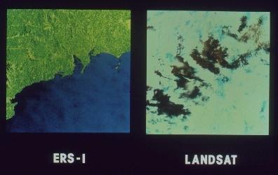
 ERS-1")
 ENVISAT")
8 Satellite-borne remote sensing radar SEASAT (1978) ERS-1 (1991), ERS-2 (1995) ENVISAT (2002)
.")

9 ASTOR In December 1999, Raytheon Systems Ltd was awarded a contract for the development of the UK Ministry of Defence Airborne Stand- Off Radar (ASTOR). The system, which includes five Bombadier Global Express business jet aircraft fitted with a derivative of the Raytheon ASARS-2 radar, is an airborne battlefield or ground surveillance radar system which will be operational with the Royal Air Force and the British Army in the year ASTOR
10 Games we can play... Ultra high-resolution SAR (and target recognition) Change detection Coherent change detection Interferometry Polarimetry Low-frequency SAR (FOPEN)


11 Sandia National Laboratories Twin Otter (Ku-band) source: Sandia Corporation -http// 11

12 Ultra-high resolution image Example of 3-look image yielding 10 cm resolution Cantalloube, H. and Dubois-Fernandez, P. Airborne X-band SAR imaging with 10 cm resolution technical challenge and preliminary results, Proc. EUSAR 2004 Conference, pp
13 Spotlight mode maximum achievable resolution Take the expression for spotlight mode azimuth resolution : x 4sin 2 A practical maximum value for might be 30º, i.e. = 60º in which case x 2 In range, r c f0 2B 2B For a fractional bandwidth of 100% B f 0 1 so r 2 target


14 Ultra-high resolution image 14


15 Coherent Change Detection (CCD) To detect whether or not a change has occurred, two images are taken of the same scene, but at different times. These images are then geometrically registered so that the same target pixels in each image align. After the images are registered, they are cross correlated pixel by pixel. Where a change has not occurred between the imaging passes, the pixels remain correlated, whereas if a change has occurred, the pixels are uncorrelated. Of course, targets that are not fixed or rigid, such as trees blowing in the wind, will naturally decorrelate and show as having "changed." While this technique is useful for detecting change, it does not measure direction or the magnitude of change.
16 Interferometric SAR - geometry B interferometric phase 2.Q. r 2 r 1 r 2 (Q=1 for single-pass, 2 for double-pass) H r 1 2.Q. r B 2r Bcos r P z 2.Q. Bcos (valid at long range or for large) y
.")
17 Interferometric SAR The Rapid Terrain Visualization (RTV) interferometric synthetic aperture radar sensor was designed and developed by Sandia National Laboratories for the Joint Precision Demonstration Project Office of the United States Army (Intelligence, Electronic Warfare & Sensors PEO). This radar provides the ability to generate highly accurate map products in real-time, including digital elevation models (DEMs), orthorectified SAR images, as well as a measure of the data quality.

18 SIR-C SAR images

19 Internal waves in SAR images
20 Internal waves in SAR images spaceborne radar illuminated zone surface / capillary waves thermocline internal wave tidal currents mean ocean surface bottom topography

21 CARABAS I Experimental Demonstrator

22 CARABAS II/LORA


23 Detection of Concealed Targets Aerial photo X-band SAR ESAR 3m res. VHF-band SAR CARABAS-II 3m res. Attenuation is significantly reduced in VHF-band SAR, but forest clutter is still a problem.
24 Conclusions SAR is a mature set of techniques, with numerous applications in geophysical remote sensing and in military surveillance As well as advances in hardware and techniques, the key thing is the ability to extract information from SAR imagery
Synthetic Aperture Radar
 Synthetic Aperture Radar Picture 1: Radar silhouette of a ship, produced with the ISAR-Processor of the Ocean Master A Synthetic Aperture Radar (SAR), or SAR, is a coherent mostly airborne or spaceborne
Introduction to Imaging Radar INF-GEO 4310
 Introduction to Imaging Radar INF-GEO 4310 22.9.2011 Literature Contact: yoann.paichard@ffi.no Suggested readings: Fundamentals of Radar Signal Processing, M.A. Richards, McGraw-Hill, 2005 High Resolution
MULTI-CHANNEL SAR EXPERIMENTS FROM THE SPACE AND FROM GROUND: POTENTIAL EVOLUTION OF PRESENT GENERATION SPACEBORNE SAR
 3 nd International Workshop on Science and Applications of SAR Polarimetry and Polarimetric Interferometry POLinSAR 2007 January 25, 2007 ESA/ESRIN Frascati, Italy MULTI-CHANNEL SAR EXPERIMENTS FROM THE
Microwave Remote Sensing (1)
") Microwave Remote Sensing (1) Microwave sensing encompasses both active and passive forms of remote sensing. The microwave portion of the spectrum covers the range from approximately 1cm to 1m in wavelength.
Microwave Remote Sensing (1) Microwave sensing encompasses both active and passive forms of remote sensing. The microwave portion of the spectrum covers the range from approximately 1cm to 1m in wavelength.
Imaging Using Microwaves
 Imaging Using Microwaves Delivering Exceptional Service in the National Interest Data created by Interferometric Synthetic Aperture Radar Unclassified Unlimited Release Name/Org: _Judith A. Ruffner, _
Acknowledgment. Process of Atmospheric Radiation. Atmospheric Transmittance. Microwaves used by Radar GMAT Principles of Remote Sensing
 GMAT 9600 Principles of Remote Sensing Week 4 Radar Background & Surface Interactions Acknowledgment Mike Chang Natural Resources Canada Process of Atmospheric Radiation Dr. Linlin Ge and Prof Bruce Forster
Remote Sensing. Ch. 3 Microwaves (Part 1 of 2)
") Remote Sensing Ch. 3 Microwaves (Part 1 of 2) 3.1 Introduction 3.2 Radar Basics 3.3 Viewing Geometry and Spatial Resolution 3.4 Radar Image Distortions 3.1 Introduction Microwave (1cm to 1m in wavelength)
Remote Sensing Ch. 3 Microwaves (Part 1 of 2) 3.1 Introduction 3.2 Radar Basics 3.3 Viewing Geometry and Spatial Resolution 3.4 Radar Image Distortions 3.1 Introduction Microwave (1cm to 1m in wavelength)
ACTIVE SENSORS RADAR
 ACTIVE SENSORS RADAR RADAR LiDAR: Light Detection And Ranging RADAR: RAdio Detection And Ranging SONAR: SOund Navigation And Ranging Used to image the ocean floor (produce bathymetic maps) and detect objects
Microwave Remote Sensing
 Provide copy on a CD of the UCAR multi-media tutorial to all in class. Assign Ch-7 and Ch-9 (for two weeks) as reading material for this class. HW#4 (Due in two weeks) Problems 1,2,3 and 4 (Chapter 7)
Introduction to Microwave Remote Sensing
 Introduction to Microwave Remote Sensing lain H. Woodhouse The University of Edinburgh Scotland Taylor & Francis Taylor & Francis Group Boca Raton London New York A CRC title, part of the Taylor & Francis
Fundamental Concepts of Radar
 Fundamental Concepts of Radar Dr Clive Alabaster & Dr Evan Hughes White Horse Radar Limited Contents Basic concepts of radar Detection Performance Target parameters measurable by a radar Primary/secondary
Bistatic experiment with the UWB-CARABAS sensor - first results and prospects of future applications
 Zurich Open Repository and Archive University of Zurich Main Library Strickhofstrasse 39 CH-8057 Zurich www.zora.uzh.ch Year: 2009 Bistatic experiment with the UWB-CARABAS sensor - first results and prospects
Special Projects Office. Mr. Lee R. Moyer Special Projects Office. DARPATech September 2000
 Mr. Lee R. Moyer DARPATech 2000 6-8 September 2000 1 CC&D Tactics Pose A Challenge to U.S. Targeting Systems The Challenge: Camouflage, Concealment and Deception techniques include: Masking: Foliage cover,
THE NASA/JPL AIRBORNE SYNTHETIC APERTURE RADAR SYSTEM. Yunling Lou, Yunjin Kim, and Jakob van Zyl
 THE NASA/JPL AIRBORNE SYNTHETIC APERTURE RADAR SYSTEM Yunling Lou, Yunjin Kim, and Jakob van Zyl Jet Propulsion Laboratory California Institute of Technology 4800 Oak Grove Drive, MS 300-243 Pasadena,
remote sensing? What are the remote sensing principles behind these Definition
 Introduction to remote sensing: Content (1/2) Definition: photogrammetry and remote sensing (PRS) Radiation sources: solar radiation (passive optical RS) earth emission (passive microwave or thermal infrared
EE 529 Remote Sensing Techniques. Introduction
 EE 529 Remote Sensing Techniques Introduction Course Contents Radar Imaging Sensors Imaging Sensors Imaging Algorithms Imaging Algorithms Course Contents (Cont( Cont d) Simulated Raw Data y r Processing
SARscape Modules for ENVI
 Visual Information Solutions SARscape Modules for ENVI Read, process, analyze, and output products from SAR data. ENVI. Easy to Use Tools. Proven Functionality. Fast Results. DEM, based on TerraSAR-X-1
Radar and Satellite Remote Sensing. Chris Allen, Associate Director Technology Center for Remote Sensing of Ice Sheets The University of Kansas
 Radar and Satellite Remote Sensing Chris Allen, Associate Director Technology Center for Remote Sensing of Ice Sheets The University of Kansas 2of 43 Outline Background ice sheet characterization Radar
RADAR REMOTE SENSING
 RADAR REMOTE SENSING Jan G.P.W. Clevers & Steven M. de Jong Chapter 8 of L&K 1 Wave theory for the EMS: Section 1.2 of L&K E = electrical field M = magnetic field c = speed of light : propagation direction
SATELLITE OCEANOGRAPHY
 SATELLITE OCEANOGRAPHY An Introduction for Oceanographers and Remote-sensing Scientists I. S. Robinson Lecturer in Physical Oceanography Department of Oceanography University of Southampton JOHN WILEY
Active and Passive Microwave Remote Sensing
 Active and Passive Microwave Remote Sensing Passive remote sensing system record EMR that was reflected (e.g., blue, green, red, and near IR) or emitted (e.g., thermal IR) from the surface of the Earth.
CEGEG046 / GEOG3051 Principles & Practice of Remote Sensing (PPRS) 8: RADAR 1
 8: RADAR 1") CEGEG046 / GEOG3051 Principles & Practice of Remote Sensing (PPRS) 8: RADAR 1 Dr. Mathias (Mat) Disney UCL Geography Office: 113, Pearson Building Tel: 7670 05921 Email: mdisney@ucl.geog.ac.uk www.geog.ucl.ac.uk/~mdisney
CEGEG046 / GEOG3051 Principles & Practice of Remote Sensing (PPRS) 8: RADAR 1 Dr. Mathias (Mat) Disney UCL Geography Office: 113, Pearson Building Tel: 7670 05921 Email: mdisney@ucl.geog.ac.uk www.geog.ucl.ac.uk/~mdisney
3. give specific seminars on topics related to assigned drill problems
 HIGH RESOLUTION AND IMAGING RADAR 1. Prerequisites Basic knowledge of radar principles. Good background in Mathematics and Physics. Basic knowledge of MATLAB programming. 2. Course format and dates The
ASAR WIDE-SWATH SINGLE-LOOK COMPLEX PRODUCTS: PROCESSING AND EXPLOITATION POTENTIAL
 ASAR WIDE-SWATH SINGLE-LOOK COMPLEX PRODUCTS: PROCESSING AND EXPLOITATION POTENTIAL Ralph Cordey (1), Tim Pearson (2), Yves-Louis Desnos (3), Betlem Rosich-Tell (3) (1) European Space Agency, ESTEC, Keplerlaan
Synthetic Aperture Radar Interferometry (InSAR) Technique (Lecture I- Tuesday 11 May 2010)
 Technique (Lecture I- Tuesday 11 May 2010)") Synthetic Aperture Radar Interferometry () Technique (Lecture I- Tuesday 11 May 2010) ISNET/CRTEAN Training Course on Synthetic Aperture Radar (SAR) Imagery: Processing, Interpretation and Applications
Synthetic Aperture Radar Interferometry () Technique (Lecture I- Tuesday 11 May 2010) ISNET/CRTEAN Training Course on Synthetic Aperture Radar (SAR) Imagery: Processing, Interpretation and Applications
Non Stationary Bistatic Synthetic Aperture Radar Processing: Assessment of Frequency Domain Processing from Simulated and Real Signals
 PIERS ONLINE, VOL. 5, NO. 2, 2009 196 Non Stationary Bistatic Synthetic Aperture Radar Processing: Assessment of Frequency Domain Processing from Simulated and Real Signals Hubert M. J. Cantalloube Office
RADAR INTERFEROMETRY FOR SAFE COAL MINING IN CHINA
 RADAR INTERFEROMETRY FOR SAFE COAL MINING IN CHINA L. Ge a, H.-C. Chang a, A. H. Ng b and C. Rizos a Cooperative Research Centre for Spatial Information School of Surveying & Spatial Information Systems,
Synthetic Aperture Radar (SAR) images features clustering using Fuzzy c- means (FCM) clustering algorithm
 images features clustering using Fuzzy c- means (FCM) clustering algorithm") Article Synthetic Aperture Radar (SAR) images features clustering using Fuzzy c- means (FCM) clustering algorithm Rashid Hussain Faculty of Engineering Science and Technology, Hamdard University, Karachi
Article Synthetic Aperture Radar (SAR) images features clustering using Fuzzy c- means (FCM) clustering algorithm Rashid Hussain Faculty of Engineering Science and Technology, Hamdard University, Karachi
THE modern airborne surveillance and reconnaissance
 INTL JOURNAL OF ELECTRONICS AND TELECOMMUNICATIONS, 2011, VOL. 57, NO. 1, PP. 37 42 Manuscript received January 19, 2011; revised February 2011. DOI: 10.2478/v10177-011-0005-z Radar and Optical Images
Estimation of Ocean Current Velocity near Incheon using Radarsat-1 SAR and HF-radar Data
 Korean Journal of Remote Sensing, Vol.23, No.5, 2007, pp.421~430 Estimation of Ocean Current Velocity near Incheon using Radarsat-1 SAR and HF-radar Data Moon-Kyung Kang and Hoonyol Lee Department of Geophysics,
Wide Swath Simultaneous Measurements of Winds and Ocean Surface Currents
 Wide Swath Simultaneous Measurements of Winds and Ocean Surface Currents Ernesto Rodriguez Jet Propulsion Laboratory California Institute of Technology 1 Thanks! The JPL DFS/ERM team for design of the
The Delay-Doppler Altimeter
 Briefing for the Coastal Altimetry Workshop The Delay-Doppler Altimeter R. K. Raney Johns Hopkins University Applied Physics Laboratory 05-07 February 2008 1 What is a Delay-Doppler altimeter? Precision
Motion Detection Using TanDEM-X Along-Track Interferometry
 Motion Detection Using TanDEM-X Along-Track Interferometry Steffen Suchandt and Hartmut Runge German Aerospace Center, Remote Sensing Technology Institute TanDEM-X Science Meeting, June 12th, 2013 Outline
Specificities of Near Nadir Ka-band Interferometric SAR Imagery
 Specificities of Near Nadir Ka-band Interferometric SAR Imagery Roger Fjørtoft, Alain Mallet, Nadine Pourthie, Jean-Marc Gaudin, Christine Lion Centre National d Etudes Spatiales (CNES), France Fifamé
Review. Guoqing Sun Department of Geography, University of Maryland ABrief
 Review Guoqing Sun Department of Geography, University of Maryland gsun@glue.umd.edu ABrief Introduction Scattering Mechanisms and Radar Image Characteristics Data Availability Example of Applications
Passive Radar Imaging
 J.L. Garry*, C.J. Baker*, G.E. Smith* and R.L. Ewing + * Electrical and Computer Engineering Ohio State University Columbus USA ABSTRACT baker@ece.osu.edu + Sensors Directorate Air Force research labs
Towards a Polarimetric SAR Processor for Airborne Sensor
 PIERS ONLINE, VOL. 6, NO. 5, 2010 465 Towards a Polarimetric SAR Processor for Airborne Sensor H. M. J. Cantalloube 1, B. Fromentin-Denoziere 1, and C. E. Nahum 2 1 ONERA (Office National d Études et Recherches
Detection of traffic congestion in airborne SAR imagery
 Detection of traffic congestion in airborne SAR imagery Gintautas Palubinskas and Hartmut Runge German Aerospace Center DLR Remote Sensing Technology Institute Oberpfaffenhofen, 82234 Wessling, Germany
Detection of a Point Target Movement with SAR Interferometry
 Journal of the Korean Society of Remote Sensing, Vol.16, No.4, 2000, pp.355~365 Detection of a Point Target Movement with SAR Interferometry Jung-Hee Jun* and Min-Ho Ka** Agency for Defence Development*,
RADAR (RAdio Detection And Ranging)
") RADAR (RAdio Detection And Ranging) CLASSIFICATION OF NONPHOTOGRAPHIC REMOTE SENSORS PASSIVE ACTIVE DIGITAL CAMERA THERMAL (e.g. TIMS) VIDEO CAMERA MULTI- SPECTRAL SCANNERS VISIBLE & NIR MICROWAVE Real
RADAR (RAdio Detection And Ranging) CLASSIFICATION OF NONPHOTOGRAPHIC REMOTE SENSORS PASSIVE ACTIVE DIGITAL CAMERA THERMAL (e.g. TIMS) VIDEO CAMERA MULTI- SPECTRAL SCANNERS VISIBLE & NIR MICROWAVE Real
Digital Processing Of Synthetic Aperture Radar Data Read & Download (pdf Kindle) Remote Sensing Digital Image...
 Remote Sensing Digital Image...") Digital Processing Of Synthetic Aperture Radar Data Algorithms And Implementation With Cdrom Artech digital Processing Of Synthetic Aperture Radar Data Algorithms And Implementation With Cdrom Artech We
Digital Processing Of Synthetic Aperture Radar Data Algorithms And Implementation With Cdrom Artech digital Processing Of Synthetic Aperture Radar Data Algorithms And Implementation With Cdrom Artech We
Digital Beamforming Architecture and Techniques for a Spaceborne Interferometric Ka-Band Mission
 Digital Beamforming Architecture and Techniques for a Spaceborne Interferometric Ka-Band Mission Marwan Younis, Paco López-Dekker, Anton Patyuchenko, and Gerhard Krieger German Aerospace Center (DLR),
Towards a polarimetric SAR processor for airborne sensor
 1 Towards a polarimetric SAR processor for airborne sensor H. M.J. Cantalloube 1, B. Fromentin-Denoziere 1, and C. E. Nahum 2 1 ONERA (Office National d Études et Recherches Aérospatiales) Palaiseau, France
RESERVOIR MONITORING USING RADAR SATELLITES
 RESERVOIR MONITORING USING RADAR SATELLITES Alain Arnaud, Johanna Granda, Geraint Cooksley ALTAMIRA INFORMATION S.L., Calle Córcega 381-387, E-08037 Barcelona, Spain. Key words: Reservoir monitoring, InSAR,
IMAGE FORMATION THROUGH WALLS USING A DISTRIBUTED RADAR SENSOR NETWORK. CIS Industrial Associates Meeting 12 May, 2004 AKELA
 IMAGE FORMATION THROUGH WALLS USING A DISTRIBUTED RADAR SENSOR NETWORK CIS Industrial Associates Meeting 12 May, 2004 THROUGH THE WALL SURVEILLANCE IS AN IMPORTANT PROBLEM Domestic law enforcement and
Introduction Active microwave Radar
 RADAR Imaging Introduction 2 Introduction Active microwave Radar Passive remote sensing systems record electromagnetic energy that was reflected or emitted from the surface of the Earth. There are also
10 Radar Imaging Radar Imaging
 10 Radar Imaging Active sensors provide their own source of energy to illuminate the target. Active sensors are generally divided into two distinct categories: imaging and non-imaging. The most common
Fusion of Heterogeneous Multisensor Data
 Fusion of Heterogeneous Multisensor Data Karsten Schulz, Antje Thiele, Ulrich Thoennessen and Erich Cadario Research Institute for Optronics and Pattern Recognition Gutleuthausstrasse 1 D 76275 Ettlingen
The Potential of Synthetic Aperture Sonar in seafloor imaging
 The Potential of Synthetic Aperture Sonar in seafloor imaging CM 2000/T:12 Ron McHugh Heriot-Watt University, Department of Computing and Electrical Engineering, Edinburgh, EH14 4AS, Scotland, U.K. Tel:
Active and Passive Microwave Remote Sensing
 Active and Passive Microwave Remote Sensing Passive remote sensing system record EMR that was reflected (e.g., blue, green, red, and near IR) or emitted (e.g., thermal IR) from the surface of the Earth.
Wideband, Long-CPI GMTI
 Wideband, Long-CPI GMTI Ali F. Yegulalp th Annual ASAP Workshop 6 March 004 This work was sponsored by the Defense Advanced Research Projects Agency and the Air Force under Air Force Contract F968-00-C-000.
IMPACT OF BAQ LEVEL ON INSAR PERFORMANCE OF RADARSAT-2 EXTENDED SWATH BEAM MODES
 IMPACT OF BAQ LEVEL ON INSAR PERFORMANCE OF RADARSAT-2 EXTENDED SWATH BEAM MODES Jayson Eppler (1), Mike Kubanski (1) (1) MDA Systems Ltd., 13800 Commerce Parkway, Richmond, British Columbia, Canada, V6V
SCANSAR AND SPOTLIGHT IMAGING OPERATION STUDY FOR SAR SATELLITE MISSION
 SCANSAR AND SPOTLIGHT IMAGING OPERATION STUDY FOR SAR SATELLITE MISSION Bor-Han Wu, Meng-Che Wu and Ming-Hwang Shie National Space Organization, National Applied Research Laboratory, Taiwan *Corresponding
Using Emulated Bistatic Radar in Highly Coherent Applications: Overview of Results
 Using Emulated Bistatic Radar in Highly Coherent Applications: Overview of Results James Palmer 1,2, Marco Martorella 3, Brad Littleton 4, and John Homer 1 1 The School of ITEE, The University of Queensland,
SAR Remote Sensing (Microwave Remote Sensing)
") iirs SAR Remote Sensing (Microwave Remote Sensing) Synthetic Aperture Radar Shashi Kumar shashi@iirs.gov.in Electromagnetic Radiation Electromagnetic radiation consists of an electrical field(e) which
iirs SAR Remote Sensing (Microwave Remote Sensing) Synthetic Aperture Radar Shashi Kumar shashi@iirs.gov.in Electromagnetic Radiation Electromagnetic radiation consists of an electrical field(e) which
FM cw Radar. FM cw Radar is a low cost technique, often used in shorter range applications"
 11: FM cw Radar 9. FM cw Radar 9.1 Principles 9.2 Radar equation 9.3 Equivalence to pulse compression 9.4 Moving targets 9.5 Practical considerations 9.6 Digital generation of wideband chirp signals FM
School of Rural and Surveying Engineering National Technical University of Athens
 Laboratory of Photogrammetry National Technical University of Athens Combined use of spaceborne optical and SAR data Incompatible data sources or a useful procedure? Charalabos Ioannidis, Dimitra Vassilaki
Principles of Space- Time Adaptive Processing 3rd Edition. By Richard Klemm. The Institution of Engineering and Technology
 Principles of Space- Time Adaptive Processing 3rd Edition By Richard Klemm The Institution of Engineering and Technology Contents Biography Preface to the first edition Preface to the second edition Preface
Principles of Pulse-Doppler Radar p. 1 Types of Doppler Radar p. 1 Definitions p. 5 Doppler Shift p. 5 Translation to Zero Intermediate Frequency p.
 Preface p. xv Principles of Pulse-Doppler Radar p. 1 Types of Doppler Radar p. 1 Definitions p. 5 Doppler Shift p. 5 Translation to Zero Intermediate Frequency p. 6 Doppler Ambiguities and Blind Speeds
Principles of Remote Sensing. Shuttle Radar Topography Mission S R T M. Michiel Damen. Dept. Earth Systems Analysis
 Principles of Remote Sensing Shuttle Radar Topography Mission S R T M Michiel Damen Dept. Earth Systems Analysis Contents Present problems with DEMs Advantage of SRTM Cell size Mission and system Radar
THE USE OF A FREQUENCY DOMAIN STEPPED FREQUENCY TECHNIQUE TO OBTAIN HIGH RANGE RESOLUTION ON THE CSIR X-BAND SAR SYSTEM
 THE USE OF A FREQUENCY DOMAIN STEPPED FREQUENCY TECHNIQUE TO OBTAIN HIGH RANGE RESOLUTION ON THE CSIR X-BAND SAR SYSTEM Willie Nel, CSIR Defencetek, Pretoria, South Africa Jan Tait, CSIR Defencetek, Pretoria,
Synthetic Aperture Radar
 Synthetic Aperture Radar J. Patrick Fitch Synthetic Aperture Radar C.S. Burrus, Consulting Editor With 93 Illustrations Springer-Verlag New York Berlin Heidelberg London Paris Tokyo J. Patrick Fitch Engineering
VHF Radar Target Detection in the Presence of Clutter *
 BULGARIAN ACADEMY OF SCIENCES CYBERNETICS AND INFORMATION TECHNOLOGIES Volume 6, No 1 Sofia 2006 VHF Radar Target Detection in the Presence of Clutter * Boriana Vassileva Institute for Parallel Processing,
UHF/VHF Synthetic Aperture Radar (SAR) systems have
 systems have") 1148 IEEE TRANSACTIONS ON IMAGE PROCESSING, VOL. 6, NO. 8, AUGUST 1997 Moving Target Detection in Foliage Using Along Track Monopulse Synthetic Aperture Radar Imaging Mehrdad Soumekh, Member, IEEE Abstract
1148 IEEE TRANSACTIONS ON IMAGE PROCESSING, VOL. 6, NO. 8, AUGUST 1997 Moving Target Detection in Foliage Using Along Track Monopulse Synthetic Aperture Radar Imaging Mehrdad Soumekh, Member, IEEE Abstract
Microwave remote sensing. Rudi Gens Alaska Satellite Facility Remote Sensing Support Center
 Microwave remote sensing Alaska Satellite Facility Remote Sensing Support Center 1 Remote Sensing Fundamental The entire range of EM radiation constitute the EM Spectrum SAR sensors sense electromagnetic
Earth Observation from a Moon based SAR: Potentials and Limitations
 Earth Observation from a Moon based SAR: Potentials and Limitations F. Bovenga 1, M. Calamia 2,3, G. Fornaro 5, G. Franceschetti 4, L. Guerriero 1, F. Lombardini 5, A. Mori 2 1 Politecnico di Bari - Dipartimento
The Shuttle Radar Topography Mission: A Global DEM
 The Shuttle Radar Topography Mission: A Global DEM Tom G. Farr, Mike Kobrick Jet Propulsion Laboratory California Institute of Technology Pasadena, CAUSA Digital topographic data are critical for a variety
SAR Image Post Processing and Exploitation. Post Image Formation Processing
 SAR Image Post Processing and Exploitation 1 This presentation is an informal communication intended for a limited audience comprised of attendees to the Institute for Computational and Experimental Research
Playa del Rey, California InSAR Ground Deformation Monitoring Interim Report H
 Playa del Rey, California InSAR Ground Deformation Monitoring Interim Report H Ref.: RV-14524 Doc.: CM-168-01 January 31, 2013 SUBMITTED TO: Southern California Gas Company 555 W. Fifth Street (Mail Location
Generation of Fine Resolution DEM at Test Areas in Alaska Using ERS SAR Tandem Pairs and Precise Orbital Data *
 Generation of Fine Resolution DEM at Test Areas in Alaska Using ERS SAR Tandem Pairs and Precise Orbital Data * O. Lawlor, T. Logan, R. Guritz, R. Fatland, S. Li, Z. Wang, and C. Olmsted Alaska SAR Facility
Imaging radar Imaging radars provide map-like coverage to one or both sides of the aircraft.
 CEE 6100 / CSS 6600 Remote Sensing Fundamentals 1 Imaging radar Imaging radars provide map-like coverage to one or both sides of the aircraft. Acronyms: RAR real aperture radar ("brute force", "incoherent")
FLY EYE RADAR MINE DETECTION GROUND PENETRATING RADAR ON TETHERED DRONE PASSIVE RADAR FOR SMALL UAS PASSIVE SMALL PROJECTILE TRACKING RADAR
 PASSIVE RADAR FOR SMALL UAS PLANAR MONOLITHICS INDUSTRIES, INC. East Coast: 7311F GROVE ROAD, FREDERICK, MD 21704 USA PHONE: 301-662-5019 FAX: 301-662-2029 West Coast: 4921 ROBERT J. MATHEWS PARKWAY, SUITE
Dynamics and Control Issues for Future Multistatic Spaceborne Radars
 Dynamics and Control Issues for Future Multistatic Spaceborne Radars Dr Stephen Hobbs Space Research Centre, School of Engineering, Cranfield University, UK Abstract Concepts for future spaceborne radar
Environmental Impact Assessment of Mining Subsidence by Using Spaceborne Radar Interferometry
 Environmental Impact Assessment of Mining Subsidence by Using Spaceborne Radar Interferometry Hsing-Chung CHANG, Linlin GE and Chris RIZOS, Australia Key words: Mining Subsidence, InSAR, DInSAR, DEM. SUMMARY
Deformation Monitoring with Terrestrial SAR Interferometry
 Lisbon, 12 October 2009 Deformation Monitoring with Terrestrial SAR Interferometry Michele Crosetto Institute of Geomatics Castelldefels (Barcelona) michele.crosetto@ideg.es 1 Content Introduction: Satellite-based
BYU SAR: A LOW COST COMPACT SYNTHETIC APERTURE RADAR
 BYU SAR: A LOW COST COMPACT SYNTHETIC APERTURE RADAR David G. Long, Bryan Jarrett, David V. Arnold, Jorge Cano ABSTRACT Synthetic Aperture Radar (SAR) systems are typically very complex and expensive.
MODULE 9 LECTURE NOTES 2 ACTIVE MICROWAVE REMOTE SENSING
 MODULE 9 LECTURE NOTES 2 ACTIVE MICROWAVE REMOTE SENSING 1. Introduction Satellite sensors are capable of actively emitting microwaves towards the earth s surface. An active microwave system transmits
Detection of Multipath Propagation Effects in SAR-Tomography with MIMO Modes
 Detection of Multipath Propagation Effects in SAR-Tomography with MIMO Modes Tobias Rommel, German Aerospace Centre (DLR), tobias.rommel@dlr.de, Germany Gerhard Krieger, German Aerospace Centre (DLR),
Executive Summary. Development of a Functional Model
 Development of a Functional Model Deutsches Zentrum für Luft- und Raumfahrt e.v. Institut für Hochfrequenztechnik und Radarsysteme Oberpfaffenhofen, Germany January 2001 Page 1 of 17 Contents 1 Introduction
PALSAR SCANSAR SCANSAR Interferometry
 PALSAR SCANSAR SCANSAR Interferometry Masanobu Shimada Japan Aerospace Exploration Agency Earth Observation Research Center ALOS PI symposium, Greece Nov. 6 2008 1 Introduction L-band PALSAR strip mode
A SAR Conjugate Mirror
 A SAR Conjugate Mirror David Hounam German Aerospace Center, DLR, Microwaves and Radar Institute Oberpfaffenhofen, D-82234 Wessling, Germany Fax: +49 8153 28 1449, E-Mail: David.Hounam@dlr.de Abstract--
Interferometric Cartwheel 1
 The Interferometric CartWheel A wheel of passive radar microsatellites for upgrading existing SAR projects D. Massonnet, P. Ultré-Guérard (DPI/EOT) E. Thouvenot (DTS/AE/INS/IR) Interferometric Cartwheel
The BYU microsar System
 The BYU microsar System David G. Long BYU Center for Remote Sensing, Microwave Earth Remote Sensing Laboratory Electrical and Computer Engineering Dept., Brigham Young University 459 Clyde Building, Provo,
Introduction to Synthetic Aperture Radar (SAR)
") Dr Patrick Berens Research Institute for High-Frequency Physics and Radar Techniques (FHR) Research Establishment for Applied Science (FGAN) 53343 Wachtberg GERMANY berens@fgande ABSTRACT The synthetic
Dr Patrick Berens Research Institute for High-Frequency Physics and Radar Techniques (FHR) Research Establishment for Applied Science (FGAN) 53343 Wachtberg GERMANY berens@fgande ABSTRACT The synthetic
MULTIPLE APERTURE INSAR (MAI) WITH C-BAND AND L-BAND DATA: NOISE AND PRECISION
 WITH C-BAND AND L-BAND DATA: NOISE AND PRECISION") MULTIPLE APERTURE INSAR (MAI) WITH C-BAND AND L-BAND DATA: NOISE AND PRECISION Noa Bechor Ben-Dov and Thomas A. Herring Massachusetts Institute of Technology, Cambridge, MA 2139, USA, Email: nbechor@chandler.mit.edu
MULTIPLE APERTURE INSAR (MAI) WITH C-BAND AND L-BAND DATA: NOISE AND PRECISION Noa Bechor Ben-Dov and Thomas A. Herring Massachusetts Institute of Technology, Cambridge, MA 2139, USA, Email: nbechor@chandler.mit.edu
Microwave Sensors Subgroup (MSSG) Report
 Report") Microwave Sensors Subgroup (MSSG) Report CEOS WGCV-35 May 13-17, 2013, Shanghai, China DONG, Xiaolong, MSSG Chair CAS Key Laboratory of Microwave Remote Sensing National Space Science Center Chinese Academy
Microwave Sensors Subgroup (MSSG) Report CEOS WGCV-35 May 13-17, 2013, Shanghai, China DONG, Xiaolong, MSSG Chair CAS Key Laboratory of Microwave Remote Sensing National Space Science Center Chinese Academy
A High-Resolution, Four-Band SAR Testbed with Real-Time Image Formation
 A High-Resolution, Four-Band SAR Testbed with Real-Time Image Formation Bruce Walker, Grant Sander, Marty Thompson, Bryan Burns, Rick Fellerhoff, and Dale Dubbert Sandia National Laboratories, P. O. Box
A new Sensor for the detection of low-flying small targets and small boats in a cluttered environment
 UNCLASSIFIED /UNLIMITED Mr. Joachim Flacke and Mr. Ryszard Bil EADS Defence & Security Defence Electronics Naval Radar Systems (OPES25) Woerthstr 85 89077 Ulm Germany joachim.flacke@eads.com / ryszard.bil@eads.com
Very High Resolution and Multichannel SAR/MTI
 Dr. Patrick Berens Research Institute for High-Frequency Physics and Radar Techniques (FHR) Research Establishment for Applied Science (FGAN) 53343 Wachtberg Germany berens@fgan.de ABSTRACT SAR is widely
IN ORDER TO address a key science goal of understanding
 2718 IEEE TRANSACTIONS ON ANTENNAS AND PROPAGATION, VOL. 55, NO. 10, OCTOBER 2007 A VHF Microstrip Antenna With Wide-Bandwidth and Dual-Polarization for Sea Ice Thickness Measurement John Huang, Fellow,
Advanced RADAR techniques
 Advanced RADAR techniques SAR + GMTI ISAR IfSAR (InSAR) GPR Noise radar Passive radar (coherent + radiometric) Secondary radars and similar systems: IFF AIS ILS Antenna size and beam width sin α/2 = λ/l
Radar Systems Engineering Lecture 14 Airborne Pulse Doppler Radar
 Radar Systems Engineering Lecture 14 Airborne Pulse Doppler Radar Dr. Robert M. O Donnell Guest Lecturer Radar Systems Course 1 Examples of Airborne Radars F-16 APG-66, 68 Courtesy of US Navy Courtesy
Correcting topography effects on terrestrial radar maps
 Correcting topography effects on terrestrial radar maps M. Jaud, R. Rouveure, P. Faure, M-O. Monod, L. Moiroux-Arvis UR TSCF Irstea, National Research Institute of Science and Technology for Environment
ESA Radar Remote Sensing Course ESA Radar Remote Sensing Course Radar, SAR, InSAR; a first introduction
 Radar, SAR, InSAR; a first introduction Ramon Hanssen Delft University of Technology The Netherlands r.f.hanssen@tudelft.nl Charles University in Prague Contents Radar background and fundamentals Imaging
URBAN MONITORING USING PERSISTENT SCATTERER INSAR AND PHOTOGRAMMETRY
 URBAN MONITORING USING PERSISTENT SCATTERER INSAR AND PHOTOGRAMMETRY Junghum Yu *, Alex Hay-Man Ng, Sungheuk Jung, Linlin Ge, and Chris Rizos. School of Surveying and Spatial Information Systems, University
DETECTION OF SMALL AIRCRAFT WITH DOPPLER WEATHER RADAR
 DETECTION OF SMALL AIRCRAFT WITH DOPPLER WEATHER RADAR Svetlana Bachmann 1, 2, Victor DeBrunner 3, Dusan Zrnic 2 1 Cooperative Institute for Mesoscale Meteorological Studies, The University of Oklahoma
Chapter 6 Spaceborne SAR Antennas for Earth Science
 Chapter 6 Spaceborne SAR Antennas for Earth Science Yunjin Kim and Rolando L. Jordan 6.1 Introduction Before the development of the first synthetic aperture radar (SAR) antenna flown in space, Jet Propulsion
Basic Radar Definitions Introduction p. 1 Basic relations p. 1 The radar equation p. 4 Transmitter power p. 9 Other forms of radar equation p.
 Basic Radar Definitions Basic relations p. 1 The radar equation p. 4 Transmitter power p. 9 Other forms of radar equation p. 11 Decibel representation of the radar equation p. 13 Radar frequencies p. 15
Boost Your Skills with On-Site Courses Tailored to Your Needs
 Boost Your Skills with On-Site Courses Tailored to Your Needs www.aticourses.com The Applied Technology Institute specializes in training programs for technical professionals. Our courses keep you current
A bluffer s guide to Radar
 A bluffer s guide to Radar Andy French December 2009 We may produce at will, from a sending station, an electrical effect in any particular region of the globe; (with which) we may determine the relative