ACTIVE SENSORS RADAR
|
|
|
- Branden Marshall
- 5 years ago
- Views:
Transcription

1 ACTIVE SENSORS RADAR RADAR

, and image our insides (ultrasound).")
2 LiDAR: Light Detection And Ranging RADAR: RAdio Detection And Ranging SONAR: SOund Navigation And Ranging Used to image the ocean floor (produce bathymetic maps) and detect objects in the ocean, perform seismic surveys (geological maps), and image our insides (ultrasound). ACTIVE SENSORS


3 Fundamental principles Real and synthetic aperture RADARs Interpreting RADAR imagery Tone, texture, polarization Shadows, foreshortening, layover Interfereometry DEMs Sensors Applications RADAR
4
5
6 RADAR is (generally) an active system Controllable source of illumination (although not light ) Sees through cloud and rain (excluding, of course, shorterwavelength weather RADAR!), and at night Images can be high(ish) resolution (3-10 m) in (x,y) horizontal dimensions Different features are portrayed or discriminated compared to visible sensors Some surface features can be seen better in radar images: ice, ocean waves soil moisture (e.g., SMAP), vegetation mass man-made objects, e.g., buildings, ships geological structures FUNDAMENTAL PRINCIPLES
 signals towards a scene 2.")
, orientation (polarization) and the time")
7 A Radar system has three primary components: 1. transmits microwave (radio) signals towards a scene 2. receives the portion of the transmitted energy backscattered from the scene 3. observes the strength (detection), orientation (polarization) and the time delay (ranging) of the return signals. FUNDAMENTAL PRINCIPLES
8 TIME WILL TELL
9 oradar systems work in a wide band of microwave frequencies. o The higher the frequency (shorter the wavelength) of a radar system, the more it is affected by weather conditions such as rain or clouds. o But the higher the transmitted frequency, the better is the resolution of the radar system. o Two naming schemes are currently in place. The older one (A- M) is still widely used, although it is an arbitrary naming scheme. RADAR FREQUENCIES


10 A surface s flatness is relative to the wavelength striking it The differences that make a difference


11 The across-track dimension is referred to as range. The along-track dimension is referred to as azimuth. In a radar system, resolution is defined for both the range and azimuth directions. RADAR TERMINOLOGY
12 RESOLUTION S TWO COMPONENTS
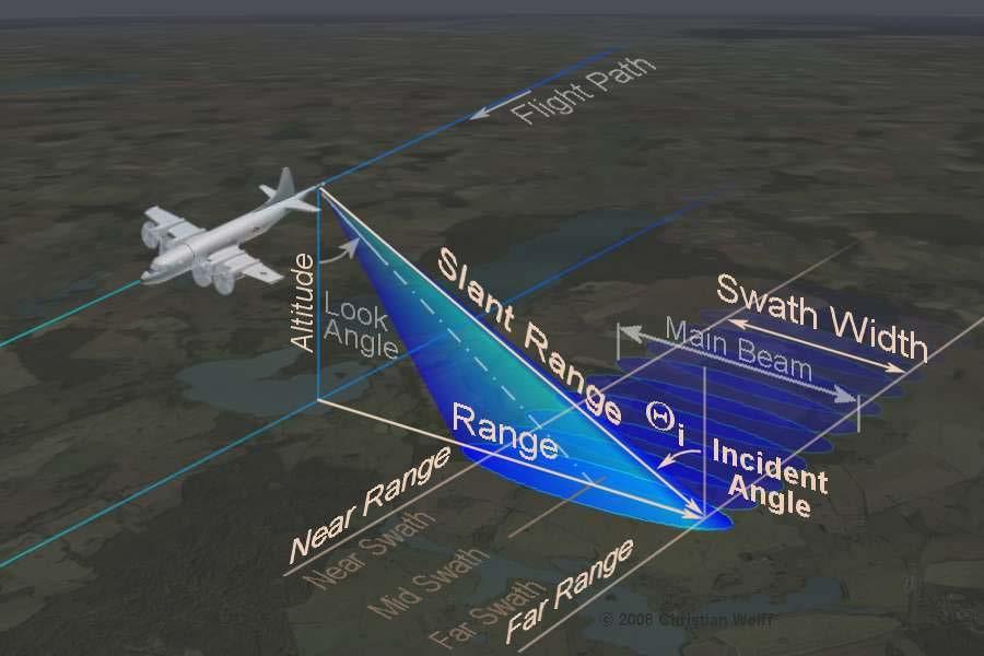
13 RADAR TERMINOLOGY
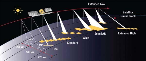
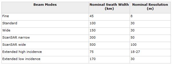
14 RADARSAT RESOLUTIONS

15 A radar system where the antenna beamwidth is controlled by the physical length of the antenna. A SLAR system in which azimuth resolution is determined by the physical length of the antenna and by the wavelength. The antenna needs to be many times longer than the wavelength to produce narrow bandwidths. (Side-Looking Airborne RADAR) The radar returns are recorded directly to produce images. REAL APERTURE RADAR

16 Advantage: Simple design and data processing. Disadvantages: Poor resolution Limited to short range, low altitude missions. Shorter wavelengths subject to atmospheric effects, scattering and dispersion. Therefore, the missions are flown at low altitudes and the coverage is small. RAR

17 A Synthetic Aperture RADAR (SAR) is a airborne or spaceborne sidelooking radar system that utilizes the flight path of the platform to simulate an extremely large antenna or aperture electronically. As an imaging sidelooking radar moves along its path, it accumulates data. In this way, continuous strips of the ground surface are illuminated parallel and to one side of the flight direction. From this record of signal data, processing is needed to produce radar images. SAR
18 Radar images have certain characteristics that are fundamentally different from images obtained by using optical sensors such as Landsat, SPOT or aerial photography. These specific characteristics are the consequence of the imaging radar technique, and are related to radiometry (speckle, texture or geometry) and polarization. DN levels in a radar image are related to the microwave backscattering properties of the surface. The intensity of the backscattered signal varies according to roughness, dielectric properties and local slope. Thus, the radar signal refers mainly to geometrical properties of the target and to the moisture content (relatively, wetter -> brighter). RADAR INTERPRETATION
 Can you tell from which direction was the image taken?")
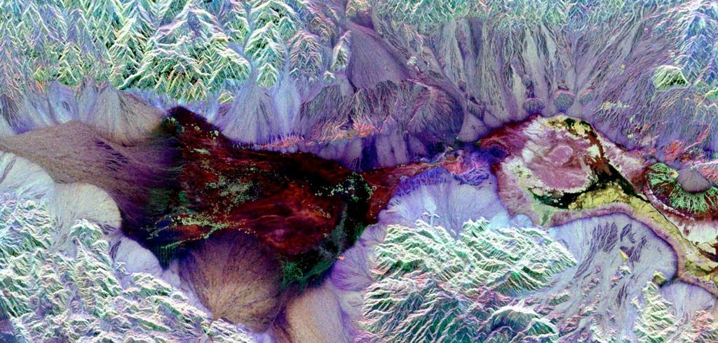
19 A synthetic aperture radar image of Death Valley, captured from the Space Shuttle in (Image: NASA/JPL) Can you tell from which direction was the image taken? (That is, where was the space shuttle relative to Death Valley?


20 Two major types of brightness variations are observable in a radar image: variations in tone variations in texture INTERPRETING RADAR IMAGERY
 may produce bright tones, depending on their shape, orientation and/or constituent materials (corner reflectors, or perpendicular to sensor)")
21 Proportional to strength of RADAR backscatter Relatively smooth targets like calm water appear as dark tones (specular) Diffuse targets like some vegetation appear as intermediate tones Man-made targets (buildings, ships) may produce bright tones, depending on their shape, orientation and/or constituent materials (corner reflectors, or perpendicular to sensor) TONE

22 RADAR TONE


23 SAFE SAILING

24 Refers to the pattern of spatial tone variations Function of spatial uniformity of scene targets For radar images texture consists of scene texture multiplied by speckle Speckle: a grainy "salt and pepper" texture in an image caused by subpixel in-homogeneities. Texture may be described as fine, medium, or coarse RADAR TEXTURE

25 RADAR TEXTURE

26 Many radars are designed to transmit microwave radiation that is either horizontally polarized (H) or vertically polarized (V). A transmitted wave of either polarization can generate a backscattered wave with a variety of polarizations. It is the analysis of these transmit and receive polarization combinations that constitutes the science of radar polarimetry. HH - for horizontal transmit and horizontal receive VV - for vertical transmit and vertical receive HV - for horizontal transmit and vertical receive, and VH - for vertical transmit and horizontal receive. RADAR POLARIZATION


")

27 A missile-guidance RADAR Illustrating V and H modes Illustration of how different polarizations (HH, VV, HV & colour composite) bring out different features in an agricultural scene RADAR POLARIZATION
28 During radar image analysis, the interpreter must keep in mind the fact that the radar "sees" the scene in a very different way from the human eye or from an optical sensor; the DN levels of the scene are related to the relative strength of the microwave energy backscattered by the landscape elements. Shadows in radar image are related to the oblique incidence angle of microwave radiation emitted by the radar system and not to geometry of solar illumination. The false visual similarity between the two types of images usually leads to confusion for beginners in interpretation of radar images. RADAR INTERPRETATION

29 A major problem with RADAR images The greater the range (i.e., distance from the sensor) the greater the problem. SHADOWS

30 SHADOWS
 will appear compressed and the length of the slope will be represented incorrectly (a' to b')")
31 Foreshortening occurs when the radar beam reaches the base of a tall feature tilted towards the radar (e.g., a mountain) before it reaches the top. Because the radar measures distance in slant-range, the slope (from point a to point b) will appear compressed and the length of the slope will be represented incorrectly (a' to b') at the image plane. FORESHORTENING

32 Layover occurs when the radar beam reaches the top of a tall feature (b) before it reaches the base (a). The return signal from the top of the feature will be received before the signal from the bottom. As a result, the top of the feature is displaced towards the radar from its true position on the ground, and lays over the base of the feature (b' to a'). The ordering of surface elements on the radar image is the reverse of the ordering on the ground. LAYOVER

33 Fundamental principles Real and synthetic aperture RADARs Interpreting RADAR imagery Tone, texture Shadows, foreshortening, layover Interfereometry DEMs Sensors Applications RADAR
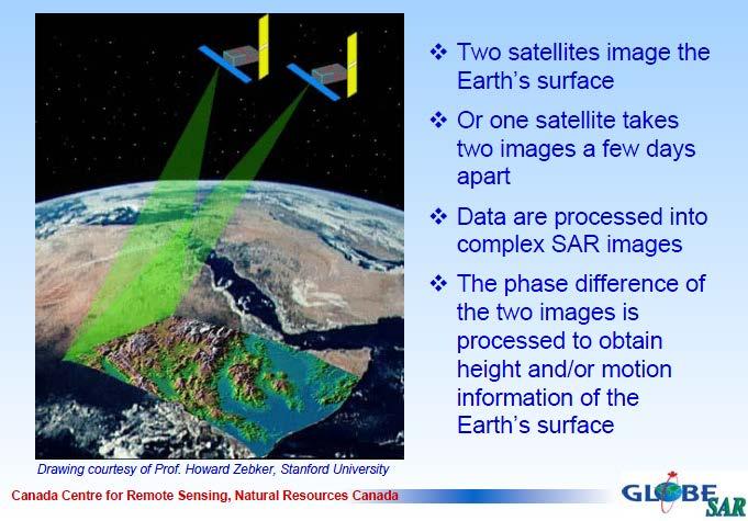
34 INTERFEROMETRY


 that flew onboard the Space Shuttle Endeavour")
35 The Shuttle Radar Topography Mission (SRTM) obtained elevation data on a near-global scale to generate the most complete high-resolution digital topographic database of Earth. SRTM consisted of a specially modified radar system (2 SARs) that flew onboard the Space Shuttle Endeavour during an 11-day mission in Feb of RADAR AND DEMS
 From several images, acquired before and after the earthquake, a differential interferogram was computed that clearly shows the seismic movements due to the earthquake.")
36 Landers earthquake (south California) of 28 June 1992 (magnitude 7.3) From several images, acquired before and after the earthquake, a differential interferogram was computed that clearly shows the seismic movements due to the earthquake. The banana-shaped fault is clearly visible. Each fringe corresponds to a co-seismic movement of 28.3 mm. The measured precision is 9 mm. INTERFEROMETRY


37 Canada: RADARSAT US: JPL AirSAR ESA: ASAR Japan: PALSAR Numerous airborne sensors Numerous aviation sensors SENSORS


38 Radar wavelength should be matched to the size of the surface features that we wish to discriminate Ice discrimination, small features, use X-band Geology mapping, large features, use L-band Foliage penetration, better at low frequencies, use K u - band In general, C-band is a good compromise APPLICATIONS AND WAVELENGTHS


39 The C-band system is designed as a medium resolution mission primarily dedicated to regular monitoring of broad geographic areas. This provides a 'big picture' overview of Canada's land mass and proximate water areas. RADARSAT
")
40 Geology Hydrology Oceanography Military Coast Guard (ship detection) Forestry Agriculture Sea ice Emergency response (floods, oil spills) APPLICATIONS
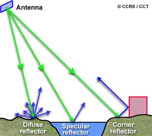
41 Active RADAR instruments include three broad classes: Imaging sensors (as described above, and the type of sensor most similar to the passive sensors (e.g., Landsat, SPOT) we are most familiar with. The other two classes are non-imaging microwave sensors: RADAR altimeters The microwave pulses are generally nadir pulses only, and it is the time of return that is the key piece of information. These devices are used on aircraft and satellites to produce topographic maps and maps of the ocean sea surface. RADAR Scatterometers These sensors are used to accurately measure backscatter and from that determine the different materials and the surface characteristics. These devices are used to estimate wind speeds based on sea surface roughness. RADAR

42 ERS-2 RADAR ALTIMETER QUICK-LOOK SEA SURFACE WIND SPEEDS


43 RADAR is a widely-used technology, but also generally a poorly-understood one. To properly work with RADAR data one needs to understand physics. SUMMARY
44
Microwave Remote Sensing (1)
") Microwave Remote Sensing (1) Microwave sensing encompasses both active and passive forms of remote sensing. The microwave portion of the spectrum covers the range from approximately 1cm to 1m in wavelength.
Microwave Remote Sensing (1) Microwave sensing encompasses both active and passive forms of remote sensing. The microwave portion of the spectrum covers the range from approximately 1cm to 1m in wavelength.
Remote Sensing. Ch. 3 Microwaves (Part 1 of 2)
") Remote Sensing Ch. 3 Microwaves (Part 1 of 2) 3.1 Introduction 3.2 Radar Basics 3.3 Viewing Geometry and Spatial Resolution 3.4 Radar Image Distortions 3.1 Introduction Microwave (1cm to 1m in wavelength)
Remote Sensing Ch. 3 Microwaves (Part 1 of 2) 3.1 Introduction 3.2 Radar Basics 3.3 Viewing Geometry and Spatial Resolution 3.4 Radar Image Distortions 3.1 Introduction Microwave (1cm to 1m in wavelength)
RADAR (RAdio Detection And Ranging)
") RADAR (RAdio Detection And Ranging) CLASSIFICATION OF NONPHOTOGRAPHIC REMOTE SENSORS PASSIVE ACTIVE DIGITAL CAMERA THERMAL (e.g. TIMS) VIDEO CAMERA MULTI- SPECTRAL SCANNERS VISIBLE & NIR MICROWAVE Real
RADAR (RAdio Detection And Ranging) CLASSIFICATION OF NONPHOTOGRAPHIC REMOTE SENSORS PASSIVE ACTIVE DIGITAL CAMERA THERMAL (e.g. TIMS) VIDEO CAMERA MULTI- SPECTRAL SCANNERS VISIBLE & NIR MICROWAVE Real
EE 529 Remote Sensing Techniques. Introduction
 EE 529 Remote Sensing Techniques Introduction Course Contents Radar Imaging Sensors Imaging Sensors Imaging Algorithms Imaging Algorithms Course Contents (Cont( Cont d) Simulated Raw Data y r Processing
Microwave Remote Sensing
 Provide copy on a CD of the UCAR multi-media tutorial to all in class. Assign Ch-7 and Ch-9 (for two weeks) as reading material for this class. HW#4 (Due in two weeks) Problems 1,2,3 and 4 (Chapter 7)
Synthetic aperture RADAR (SAR) principles/instruments October 31, 2018
 principles/instruments October 31, 2018") GEOL 1460/2461 Ramsey Introduction to Remote Sensing Fall, 2018 Synthetic aperture RADAR (SAR) principles/instruments October 31, 2018 I. Reminder: Upcoming Dates lab #2 reports due by the start of next
GEOL 1460/2461 Ramsey Introduction to Remote Sensing Fall, 2018 Synthetic aperture RADAR (SAR) principles/instruments October 31, 2018 I. Reminder: Upcoming Dates lab #2 reports due by the start of next
Synthetic Aperture Radar
 Synthetic Aperture Radar Picture 1: Radar silhouette of a ship, produced with the ISAR-Processor of the Ocean Master A Synthetic Aperture Radar (SAR), or SAR, is a coherent mostly airborne or spaceborne
Introduction Active microwave Radar
 RADAR Imaging Introduction 2 Introduction Active microwave Radar Passive remote sensing systems record electromagnetic energy that was reflected or emitted from the surface of the Earth. There are also
Acknowledgment. Process of Atmospheric Radiation. Atmospheric Transmittance. Microwaves used by Radar GMAT Principles of Remote Sensing
 GMAT 9600 Principles of Remote Sensing Week 4 Radar Background & Surface Interactions Acknowledgment Mike Chang Natural Resources Canada Process of Atmospheric Radiation Dr. Linlin Ge and Prof Bruce Forster
RADAR REMOTE SENSING
 RADAR REMOTE SENSING Jan G.P.W. Clevers & Steven M. de Jong Chapter 8 of L&K 1 Wave theory for the EMS: Section 1.2 of L&K E = electrical field M = magnetic field c = speed of light : propagation direction
Radar Imaging Wavelengths
 A Basic Introduction to Radar Remote Sensing ~~~~~~~~~~ Rev. Ronald J. Wasowski, C.S.C. Associate Professor of Environmental Science University of Portland Portland, Oregon 3 November 2015 Radar Imaging
Active and Passive Microwave Remote Sensing
 Active and Passive Microwave Remote Sensing Passive remote sensing system record EMR that was reflected (e.g., blue, green, red, and near IR) or emitted (e.g., thermal IR) from the surface of the Earth.
CEGEG046 / GEOG3051 Principles & Practice of Remote Sensing (PPRS) 8: RADAR 1
 8: RADAR 1") CEGEG046 / GEOG3051 Principles & Practice of Remote Sensing (PPRS) 8: RADAR 1 Dr. Mathias (Mat) Disney UCL Geography Office: 113, Pearson Building Tel: 7670 05921 Email: mdisney@ucl.geog.ac.uk www.geog.ucl.ac.uk/~mdisney
CEGEG046 / GEOG3051 Principles & Practice of Remote Sensing (PPRS) 8: RADAR 1 Dr. Mathias (Mat) Disney UCL Geography Office: 113, Pearson Building Tel: 7670 05921 Email: mdisney@ucl.geog.ac.uk www.geog.ucl.ac.uk/~mdisney
Microwave remote sensing. Rudi Gens Alaska Satellite Facility Remote Sensing Support Center
 Microwave remote sensing Alaska Satellite Facility Remote Sensing Support Center 1 Remote Sensing Fundamental The entire range of EM radiation constitute the EM Spectrum SAR sensors sense electromagnetic
SAR Remote Sensing (Microwave Remote Sensing)
") iirs SAR Remote Sensing (Microwave Remote Sensing) Synthetic Aperture Radar Shashi Kumar shashi@iirs.gov.in Electromagnetic Radiation Electromagnetic radiation consists of an electrical field(e) which
iirs SAR Remote Sensing (Microwave Remote Sensing) Synthetic Aperture Radar Shashi Kumar shashi@iirs.gov.in Electromagnetic Radiation Electromagnetic radiation consists of an electrical field(e) which
10 Radar Imaging Radar Imaging
 10 Radar Imaging Active sensors provide their own source of energy to illuminate the target. Active sensors are generally divided into two distinct categories: imaging and non-imaging. The most common
Imaging radar Imaging radars provide map-like coverage to one or both sides of the aircraft.
 CEE 6100 / CSS 6600 Remote Sensing Fundamentals 1 Imaging radar Imaging radars provide map-like coverage to one or both sides of the aircraft. Acronyms: RAR real aperture radar ("brute force", "incoherent")
Active and Passive Microwave Remote Sensing
 Active and Passive Microwave Remote Sensing Passive remote sensing system record EMR that was reflected (e.g., blue, green, red, and near IR) or emitted (e.g., thermal IR) from the surface of the Earth.
Introduction to Radar
 National Aeronautics and Space Administration ARSET Applied Remote Sensing Training http://arset.gsfc.nasa.gov @NASAARSET Introduction to Radar Jul. 16, 2016 www.nasa.gov Objective The objective of this
Introduction to Imaging Radar INF-GEO 4310
 Introduction to Imaging Radar INF-GEO 4310 22.9.2011 Literature Contact: yoann.paichard@ffi.no Suggested readings: Fundamentals of Radar Signal Processing, M.A. Richards, McGraw-Hill, 2005 High Resolution
remote sensing? What are the remote sensing principles behind these Definition
 Introduction to remote sensing: Content (1/2) Definition: photogrammetry and remote sensing (PRS) Radiation sources: solar radiation (passive optical RS) earth emission (passive microwave or thermal infrared
Review. Guoqing Sun Department of Geography, University of Maryland ABrief
 Review Guoqing Sun Department of Geography, University of Maryland gsun@glue.umd.edu ABrief Introduction Scattering Mechanisms and Radar Image Characteristics Data Availability Example of Applications
MODULE 9 LECTURE NOTES 2 ACTIVE MICROWAVE REMOTE SENSING
 MODULE 9 LECTURE NOTES 2 ACTIVE MICROWAVE REMOTE SENSING 1. Introduction Satellite sensors are capable of actively emitting microwaves towards the earth s surface. An active microwave system transmits
Interpreting Digital RADAR Images
 R A D A R Introduction to Interpreting Digital Radar Images I N T E R P R E T Interpreting Digital RADAR Images with TNTmips page 1 Before Getting Started Airborne and satellite radar systems are versatile
Co-ReSyF RA lecture: Vessel detection and oil spill detection
 This project has received funding from the European Union s Horizon 2020 Research and Innovation Programme under grant agreement no 687289 Co-ReSyF RA lecture: Vessel detection and oil spill detection
ACTIVE MICROWAVE REMOTE SENSING OF LAND SURFACE HYDROLOGY
 Basics, methods & applications ACTIVE MICROWAVE REMOTE SENSING OF LAND SURFACE HYDROLOGY Annett.Bartsch@polarresearch.at Active microwave remote sensing of land surface hydrology Landsurface hydrology:
School of Rural and Surveying Engineering National Technical University of Athens
 Laboratory of Photogrammetry National Technical University of Athens Combined use of spaceborne optical and SAR data Incompatible data sources or a useful procedure? Charalabos Ioannidis, Dimitra Vassilaki
SATELLITE OCEANOGRAPHY
 SATELLITE OCEANOGRAPHY An Introduction for Oceanographers and Remote-sensing Scientists I. S. Robinson Lecturer in Physical Oceanography Department of Oceanography University of Southampton JOHN WILEY
Govt. Engineering College Jhalawar Model Question Paper Subject- Remote Sensing & GIS
 Govt. Engineering College Jhalawar Model Question Paper Subject- Remote Sensing & GIS Time: Max. Marks: Q1. What is remote Sensing? Explain the basic components of a Remote Sensing system. Q2. What is
THE NASA/JPL AIRBORNE SYNTHETIC APERTURE RADAR SYSTEM. Yunling Lou, Yunjin Kim, and Jakob van Zyl
 THE NASA/JPL AIRBORNE SYNTHETIC APERTURE RADAR SYSTEM Yunling Lou, Yunjin Kim, and Jakob van Zyl Jet Propulsion Laboratory California Institute of Technology 4800 Oak Grove Drive, MS 300-243 Pasadena,
UNERSITY OF NAIROBI UNIT: PRICIPLES AND APPLICATIONS OF REMOTE SENSING AND APLLIED CLIMATOLOGY
 UNERSITY OF NAIROBI DEPARTMENT OF METEOROLOGY UNIT: PRICIPLES AND APPLICATIONS OF REMOTE SENSING AND APLLIED CLIMATOLOGY COURSE CODE: SMR 308 GROUP TWO: SENSORS MEMBERS OF GROUP TWO 1. MUTISYA J.M I10/2784/2006
ESA Radar Remote Sensing Course ESA Radar Remote Sensing Course Radar, SAR, InSAR; a first introduction
 Radar, SAR, InSAR; a first introduction Ramon Hanssen Delft University of Technology The Netherlands r.f.hanssen@tudelft.nl Charles University in Prague Contents Radar background and fundamentals Imaging
ANALYSIS OF SRTM HEIGHT MODELS
 ANALYSIS OF SRTM HEIGHT MODELS Sefercik, U. *, Jacobsen, K.** * Karaelmas University, Zonguldak, Turkey, ugsefercik@hotmail.com **Institute of Photogrammetry and GeoInformation, University of Hannover,
All rights reserved. ENVI, IDL and Jagwire are trademarks of Exelis, Inc. All other marks are the property of their respective owners.
 SAR Analysis Made Easy with SARscape 5.1 All rights reserved. ENVI, IDL and Jagwire are trademarks of Exelis, Inc. All other marks are the property of their respective owners. 2014, Exelis Visual Information
Introduction to Microwave Remote Sensing
 Introduction to Microwave Remote Sensing lain H. Woodhouse The University of Edinburgh Scotland Taylor & Francis Taylor & Francis Group Boca Raton London New York A CRC title, part of the Taylor & Francis
Interpreting land surface features. SWAC module 3
 Interpreting land surface features SWAC module 3 Interpreting land surface features SWAC module 3 Different kinds of image Panchromatic image True-color image False-color image EMR : NASA Echo the bat
An Introduction to Geomatics. Prepared by: Dr. Maher A. El-Hallaq خاص بطلبة مساق مقدمة في علم. Associate Professor of Surveying IUG
 An Introduction to Geomatics خاص بطلبة مساق مقدمة في علم الجيوماتكس Prepared by: Dr. Maher A. El-Hallaq Associate Professor of Surveying IUG 1 Airborne Imagery Dr. Maher A. El-Hallaq Associate Professor
SAR Multi-Temporal Applications
 SAR Multi-Temporal Applications 83230359-DOC-TAS-EN-001 Contents 2 Advantages of SAR Remote Sensing Technology All weather any time Frequencies and polarisations Interferometry and 3D mapping Change Detection
746A27 Remote Sensing and GIS
 746A27 Remote Sensing and GIS Lecture 1 Concepts of remote sensing and Basic principle of Photogrammetry Chandan Roy Guest Lecturer Department of Computer and Information Science Linköping University What
Remote Sensing 1 Principles of visible and radar remote sensing & sensors
 Remote Sensing 1 Principles of visible and radar remote sensing & sensors Nick Barrand School of Geography, Earth & Environmental Sciences University of Birmingham, UK Field glaciologist collecting data
LE/ESSE Payload Design
 LE/ESSE4360 - Payload Design 3.2 Spacecraft Sensors Introduction to Sensors Earth, Moon, Mars, and Beyond Dr. Jinjun Shan, Professor of Space Engineering Department of Earth and Space Science and Engineering
Introduction to Remote Sensing Fundamentals of Satellite Remote Sensing. Mads Olander Rasmussen
 Introduction to Remote Sensing Fundamentals of Satellite Remote Sensing Mads Olander Rasmussen (mora@dhi-gras.com) 01. Introduction to Remote Sensing DHI What is remote sensing? the art, science, and technology
Specificities of Near Nadir Ka-band Interferometric SAR Imagery
 Specificities of Near Nadir Ka-band Interferometric SAR Imagery Roger Fjørtoft, Alain Mallet, Nadine Pourthie, Jean-Marc Gaudin, Christine Lion Centre National d Etudes Spatiales (CNES), France Fifamé
Int n r t o r d o u d c u ti t on o n to t o Remote Sensing
 Introduction to Remote Sensing Definition of Remote Sensing Remote sensing refers to the activities of recording/observing/perceiving(sensing)objects or events at far away (remote) places. In remote sensing,
SAR Remote Sensing. Introduction into SAR. Data characteristics, challenges, and applications.
 SAR Remote Sensing Introduction into SAR. Data characteristics, challenges, and applications. PD Dr. habil. Christian Thiel, Friedrich-Schiller-University Jena DLR-HR Jena & Friedrich-Schiller-University
Outline. Introduction. Introduction: Film Emulsions. Sensor Systems. Types of Remote Sensing. A/Prof Linlin Ge. Photographic systems (cf(
 GMAT x600 Remote Sensing / Earth Observation Types of Sensor Systems (1) Outline Image Sensor Systems (i) Line Scanning Sensor Systems (passive) (ii) Array Sensor Systems (passive) (iii) Antenna Radar
Sources of Geographic Information
 Sources of Geographic Information Data properties: Spatial data, i.e. data that are associated with geographic locations Data format: digital (analog data for traditional paper maps) Data Inputs: sampled
Copernicus Introduction Lisbon, Portugal 13 th & 14 th February 2014
 Copernicus Introduction Lisbon, Portugal 13 th & 14 th February 2014 Contents Introduction GMES Copernicus Six thematic areas Infrastructure Space data An introduction to Remote Sensing In-situ data Applications
MODULE 9 LECTURE NOTES 1 PASSIVE MICROWAVE REMOTE SENSING
 MODULE 9 LECTURE NOTES 1 PASSIVE MICROWAVE REMOTE SENSING 1. Introduction The microwave portion of the electromagnetic spectrum involves wavelengths within a range of 1 mm to 1 m. Microwaves possess all
Soil moisture retrieval using ALOS PALSAR
 Soil moisture retrieval using ALOS PALSAR T. J. Jackson, R. Bindlish and M. Cosh USDA ARS Hydrology and Remote Sensing Lab, Beltsville, MD J. Shi University of California Santa Barbara, CA November 6,
Introduction to Remote Sensing
 Introduction to Remote Sensing Outline Remote Sensing Defined Resolution Electromagnetic Energy (EMR) Types Interpretation Applications Remote Sensing Defined Remote Sensing is: The art and science of
9/13/2011. Training Course Remote Sensing Basic Theory & Image Processing Methods September 2011
 Training Course Remote Sensing Basic Theory & Image Processing Methods 19 23 September 2011 DIGITAL TERRAIN MODELS Introduction Michiel Damen (April 2011) damen@itc.nl 1 Digital Elevation and Terrain Models
NEXTMAP. P-Band. Airborne Radar Imaging Technology. Key Benefits & Features INTERMAP.COM. Answers Now
 INTERMAP.COM Answers Now NEXTMAP P-Band Airborne Radar Imaging Technology Intermap is proud to announce the latest advancement of their Synthetic Aperture Radar (SAR) imaging technology. Leveraging over
Radar Imagery for Forest Cover Mapping
 Purdue University Purdue e-pubs LARS Symposia Laboratory for Applications of Remote Sensing 1-1-1981 Radar magery for Forest Cover Mapping D. J. Knowlton R. M. Hoffer Follow this and additional works at:
Dynamics and Control Issues for Future Multistatic Spaceborne Radars
 Dynamics and Control Issues for Future Multistatic Spaceborne Radars Dr Stephen Hobbs Space Research Centre, School of Engineering, Cranfield University, UK Abstract Concepts for future spaceborne radar
COMPARISON OF INFORMATION CONTENTS OF HIGH RESOLUTION SPACE IMAGES
 COMPARISON OF INFORMATION CONTENTS OF HIGH RESOLUTION SPACE IMAGES H. Topan*, G. Büyüksalih*, K. Jacobsen ** * Karaelmas University Zonguldak, Turkey ** University of Hannover, Germany htopan@karaelmas.edu.tr,
Introduction to RADAR Remote Sensing for Vegetation Mapping and Monitoring. Wayne Walker, Ph.D.
 Introduction to RADAR Remote Sensing for Vegetation Mapping and Monitoring Wayne Walker, Ph.D. Outline What is RADAR (and what does it measure)? RADAR as an active sensor Applications of RADAR to vegetation
Remote Sensing of the Environment
 Remote Sensing of the Environment An Earth Resource Perspective John R. Jensen University of South Carolina Prentice Hall Upper Saddle River, New Jersey 07458 Brief Contents 1 Remote Sensing of the Environment
Development of the Technology of Utilization of Airborne Synthetic Aperture Radar (SAR)
") Development of the Technology of Utilization of Airborne Synthetic Aperture Radar (SAR) Mamoru Koarai, Kouichi Moteki, Nobuyuki Watanabe, Takaki Okatani,Youko Yamada and Kaoru Matsuo Geographical Survey
Development of the Technology of Utilization of Airborne Synthetic Aperture Radar (SAR) Mamoru Koarai, Kouichi Moteki, Nobuyuki Watanabe, Takaki Okatani,Youko Yamada and Kaoru Matsuo Geographical Survey
Principles of Remote Sensing. Shuttle Radar Topography Mission S R T M. Michiel Damen. Dept. Earth Systems Analysis
 Principles of Remote Sensing Shuttle Radar Topography Mission S R T M Michiel Damen Dept. Earth Systems Analysis Contents Present problems with DEMs Advantage of SRTM Cell size Mission and system Radar
Synthetic Aperture Radar Interferometry (InSAR) Technique (Lecture I- Tuesday 11 May 2010)
 Technique (Lecture I- Tuesday 11 May 2010)") Synthetic Aperture Radar Interferometry () Technique (Lecture I- Tuesday 11 May 2010) ISNET/CRTEAN Training Course on Synthetic Aperture Radar (SAR) Imagery: Processing, Interpretation and Applications
Synthetic Aperture Radar Interferometry () Technique (Lecture I- Tuesday 11 May 2010) ISNET/CRTEAN Training Course on Synthetic Aperture Radar (SAR) Imagery: Processing, Interpretation and Applications
EarthData International
 (Part 3) EarthData International >> By Marc S. Cheves, LS I recently met with Jeff Leonard, President and General Manager of EarthData International in Frederick, Maryland, and Tom Harrington, President
Outline Remote Sensing Defined Resolution Electromagnetic Energy (EMR) Types Interpretation Applications
 Types Interpretation Applications") Introduction to Remote Sensing Outline Remote Sensing Defined Resolution Electromagnetic Energy (EMR) Types Interpretation Applications Remote Sensing Defined Remote Sensing is: The art and science of
Introduction to Remote Sensing Outline Remote Sensing Defined Resolution Electromagnetic Energy (EMR) Types Interpretation Applications Remote Sensing Defined Remote Sensing is: The art and science of
RADAR INTERFEROMETRY FOR SAFE COAL MINING IN CHINA
 RADAR INTERFEROMETRY FOR SAFE COAL MINING IN CHINA L. Ge a, H.-C. Chang a, A. H. Ng b and C. Rizos a Cooperative Research Centre for Spatial Information School of Surveying & Spatial Information Systems,
Sub-Mesoscale Imaging of the Ionosphere with SMAP
 Sub-Mesoscale Imaging of the Ionosphere with SMAP Tony Freeman Xiaoqing Pi Xiaoyan Zhou CEOS Workshop, ASF, Fairbanks, Alaska, December 2009 1 Soil Moisture Active-Passive (SMAP) Overview Baseline Mission
Basic SAR Analysis. New York City. CEE 6100/ CSS 6600 Remote Sensing Fundamentals Lab #8: Radar
 1 Basic SAR Analysis Images for this tutorial were taken from the SIR C/X archive at http://www.jpl.nasa.gov/radar/sircxsar/. This web site has a good collection of examples of multi frequency, multi polarization
The studies began when the Tiros satellites (1960) provided man s first synoptic view of the Earth s weather systems.
 provided man s first synoptic view of the Earth s weather systems.") Remote sensing of the Earth from orbital altitudes was recognized in the mid-1960 s as a potential technique for obtaining information important for the effective use and conservation of natural resources.
Remote sensing of the Earth from orbital altitudes was recognized in the mid-1960 s as a potential technique for obtaining information important for the effective use and conservation of natural resources.
Passive Microwave Sensors LIDAR Remote Sensing Laser Altimetry. 28 April 2003
 Passive Microwave Sensors LIDAR Remote Sensing Laser Altimetry 28 April 2003 Outline Passive Microwave Radiometry Rayleigh-Jeans approximation Brightness temperature Emissivity and dielectric constant
NON-PHOTOGRAPHIC SYSTEMS: Multispectral Scanners Medium and coarse resolution sensor comparisons: Landsat, SPOT, AVHRR and MODIS
 NON-PHOTOGRAPHIC SYSTEMS: Multispectral Scanners Medium and coarse resolution sensor comparisons: Landsat, SPOT, AVHRR and MODIS CLASSIFICATION OF NONPHOTOGRAPHIC REMOTE SENSORS PASSIVE ACTIVE DIGITAL
Ghazanfar A. Khattak National Centre of Excellence in Geology University of Peshawar
 INTRODUCTION TO REMOTE SENSING Ghazanfar A. Khattak National Centre of Excellence in Geology University of Peshawar WHAT IS REMOTE SENSING? Remote sensing is the science of acquiring information about
SAR Imagery: Airborne or Spaceborne? Presenter: M. Lorraine Tighe PhD
 SAR Imagery: Airborne or Spaceborne? Presenter: M. Lorraine Tighe PhD Introduction The geospatial community has seen a plethora of spaceborne SAR imagery systems where there are now extensive archives
Outline Remote Sensing Defined Resolution Electromagnetic Energy (EMR) Types Interpretation Applications 2
 Types Interpretation Applications 2") Introduction to Remote Sensing 1 Outline Remote Sensing Defined Resolution Electromagnetic Energy (EMR) Types Interpretation Applications 2 Remote Sensing Defined Remote Sensing is: The art and science
Introduction to Remote Sensing 1 Outline Remote Sensing Defined Resolution Electromagnetic Energy (EMR) Types Interpretation Applications 2 Remote Sensing Defined Remote Sensing is: The art and science
CNES PRIORITIES IN POLAR AND CRYOSPHERE RESEARCH
 Polar Space Task Group 3rd Session CNES PRIORITIES IN POLAR AND CRYOSPHERE RESEARCH Juliette Lambin, Steven Hosford Wednesday, May 22th, 2013 Paris, France 1 OUTLINE CNES MISSIONS FOR POLAR/CRYOSPHERE
JP Stevens High School: Remote Sensing
 1 Name(s): ANSWER KEY Date: Team name: JP Stevens High School: Remote Sensing Scoring: Part I - /18 Part II - /40 Part III - /16 Part IV - /14 Part V - /93 Total: /181 2 I. History (3 pts each) 1. What
SARscape Modules for ENVI
 Visual Information Solutions SARscape Modules for ENVI Read, process, analyze, and output products from SAR data. ENVI. Easy to Use Tools. Proven Functionality. Fast Results. DEM, based on TerraSAR-X-1
MODULE 7 LECTURE NOTES 3 SHUTTLE RADAR TOPOGRAPHIC MISSION DATA
 MODULE 7 LECTURE NOTES 3 SHUTTLE RADAR TOPOGRAPHIC MISSION DATA 1. Introduction Availability of a reasonably accurate elevation information for many parts of the world was once very much limited. Dense
Radar Polarimetry- Potential for Geosciences
 Radar Polarimetry- Potential for Geosciences Franziska Kersten Department of geology, TU Freiberg Abstract. The ability of Radar Polarimetry to obtain information about physical properties of the surface
ASAR Training Course, Hanoi, 25 February 7 March 2008 Introduction to Radar Interferometry
 Introduction to Radar Interferometry Presenter: F.Sarti (ESA/ESRIN) 1 Imaging Radar : reminder 2 Physics of radar Potentialities of radar All-weather observation system (active system) Penetration capabilities
Geo/SAT 2 INTRODUCTION TO REMOTE SENSING
 Geo/SAT 2 INTRODUCTION TO REMOTE SENSING Paul R. Baumann, Professor Emeritus State University of New York College at Oneonta Oneonta, New York 13820 USA COPYRIGHT 2008 Paul R. Baumann Introduction Remote
MULTI-CHANNEL SAR EXPERIMENTS FROM THE SPACE AND FROM GROUND: POTENTIAL EVOLUTION OF PRESENT GENERATION SPACEBORNE SAR
 3 nd International Workshop on Science and Applications of SAR Polarimetry and Polarimetric Interferometry POLinSAR 2007 January 25, 2007 ESA/ESRIN Frascati, Italy MULTI-CHANNEL SAR EXPERIMENTS FROM THE
REMOTE SENSING FOR FLOOD HAZARD STUDIES.
 REMOTE SENSING FOR FLOOD HAZARD STUDIES. OPTICAL SENSORS. 1 DRS. NANETTE C. KINGMA 1 Optical Remote Sensing for flood hazard studies. 2 2 Floods & use of remote sensing. Floods often leaves its imprint
746A27 Remote Sensing and GIS. Multi spectral, thermal and hyper spectral sensing and usage
 746A27 Remote Sensing and GIS Lecture 3 Multi spectral, thermal and hyper spectral sensing and usage Chandan Roy Guest Lecturer Department of Computer and Information Science Linköping University Multi
The Global Imager (GLI)
") The Global Imager (GLI) Launch : Dec.14, 2002 Initial check out : to Apr.14, 2003 (~L+4) First image: Jan.25, 2003 Second image: Feb.6 and 7, 2003 Calibration and validation : to Dec.14, 2003(~L+4) for
The Global Imager (GLI) Launch : Dec.14, 2002 Initial check out : to Apr.14, 2003 (~L+4) First image: Jan.25, 2003 Second image: Feb.6 and 7, 2003 Calibration and validation : to Dec.14, 2003(~L+4) for
RECOMMENDATION ITU-R SA.1624 *
 Rec. ITU-R SA.1624 1 RECOMMENDATION ITU-R SA.1624 * Sharing between the Earth exploration-satellite (passive) and airborne altimeters in the aeronautical radionavigation service in the band 4 200-4 400
THREE-DIMENSIONAL MAPPING USING BOTH AIRBORNE AND SPACEBORNE IFSAR TECHNOLOGIES ABSTRACT INTRODUCTION
 THREE-DIMENSIONAL MAPPING USING BOTH AIRBORNE AND SPACEBORNE IFSAR TECHNOLOGIES Trina Kuuskivi Manager of Value Added Products and Services, Intermap Technologies Corp. 2 Gurdwara Rd, Suite 200, Ottawa,
Lecture Notes Prepared by Prof. J. Francis Spring Remote Sensing Instruments
 Lecture Notes Prepared by Prof. J. Francis Spring 2005 Remote Sensing Instruments Material from Remote Sensing Instrumentation in Weather Satellites: Systems, Data, and Environmental Applications by Rao,
Oil spill detection in the Chinese Seas by spaceborne synthetic aperture radars: challenges and pitfalls (Project: OPAC )
") Oil spill detection in the Chinese Seas by spaceborne synthetic aperture radars: challenges and pitfalls (Project: 10705 OPAC ) Werner Alpers Institute of Oceanography, University of Hamburg, Hamburg,
Oil spill detection in the Chinese Seas by spaceborne synthetic aperture radars: challenges and pitfalls (Project: 10705 OPAC ) Werner Alpers Institute of Oceanography, University of Hamburg, Hamburg,
Important Missions. weather forecasting and monitoring communication navigation military earth resource observation LANDSAT SEASAT SPOT IRS
 Fundamentals of Remote Sensing Pranjit Kr. Sarma, Ph.D. Assistant Professor Department of Geography Mangaldai College Email: prangis@gmail.com Ph. No +91 94357 04398 Remote Sensing Remote sensing is defined
1. Theory of remote sensing and spectrum
 1. Theory of remote sensing and spectrum 7 August 2014 ONUMA Takumi Outline of Presentation Electromagnetic wave and wavelength Sensor type Spectrum Spatial resolution Spectral resolution Mineral mapping
Geometry of Aerial Photographs
 Geometry of Aerial Photographs Aerial Cameras Aerial cameras must be (details in lectures): Geometrically stable Have fast and efficient shutters Have high geometric and optical quality lenses They can
Microwave sensors (present and future)
") Proc. Indian Acad. Sci. (Engg. sea.), Vol. 6, Pt. 2, June 1983, pp. 109-119. 9 Printed in India. Microwave sensors (present and future) 1. Introduction O P N CALLA Communications Area, Space Applications
Proc. Indian Acad. Sci. (Engg. sea.), Vol. 6, Pt. 2, June 1983, pp. 109-119. 9 Printed in India. Microwave sensors (present and future) 1. Introduction O P N CALLA Communications Area, Space Applications
INF-GEO Introduction to remote sensing
 INF-GEO 4310 Introduction to remote sensing Anne Solberg (anne@ifi.uio.no) Satellites, orbits and repeat cycles Optical remote sensings Based on a tutorial adapted from Canadian Center for Remote Sensing,
Monitoring agricultural plantations with remote sensing imagery
 MPRA Munich Personal RePEc Archive Monitoring agricultural plantations with remote sensing imagery Camelia Slave and Anca Rotman University of Agronomic Sciences and Veterinary Medicine - Bucharest Romania,
INTRODUCTORY REMOTE SENSING. Geob 373
 INTRODUCTORY REMOTE SENSING Geob 373 Landsat 7 15 m image highlighting the geology of Oman http://www.satimagingcorp.com/gallery-landsat.html ASTER 15 m SWIR image, Escondida Mine, Chile http://www.satimagingcorp.com/satellite-sensors/aster.html
Sample Copy. Not For Distribution.
 Photogrammetry, GIS & Remote Sensing Quick Reference Book i EDUCREATION PUBLISHING Shubham Vihar, Mangla, Bilaspur, Chhattisgarh - 495001 Website: www.educreation.in Copyright, 2017, S.S. Manugula, V.
Synthetic Aperture Radar. Hugh Griffiths THALES/Royal Academy of Engineering Chair of RF Sensors University College London
 Synthetic Aperture Radar Hugh Griffiths THALES/Royal Academy of Engineering Chair of RF Sensors University College London CEOI Training Workshop Designing and Delivering and Instrument Concept 15 March
SCATTERING POLARIMETRY PART 1. Dr. A. Bhattacharya (Slide courtesy Prof. E. Pottier and Prof. L. Ferro-Famil)
") SCATTERING POLARIMETRY PART 1 Dr. A. Bhattacharya (Slide courtesy Prof. E. Pottier and Prof. L. Ferro-Famil) 2 That s how it looks! Wave Polarisation An electromagnetic (EM) plane wave has time-varying
SCATTERING POLARIMETRY PART 1 Dr. A. Bhattacharya (Slide courtesy Prof. E. Pottier and Prof. L. Ferro-Famil) 2 That s how it looks! Wave Polarisation An electromagnetic (EM) plane wave has time-varying
Aerial photography and Remote Sensing. Bikini Atoll, 2013 (60 years after nuclear bomb testing)
") Aerial photography and Remote Sensing Bikini Atoll, 2013 (60 years after nuclear bomb testing) Computers have linked mapping techniques under the umbrella term : Geomatics includes all the following spatial
Aerial photography and Remote Sensing Bikini Atoll, 2013 (60 years after nuclear bomb testing) Computers have linked mapping techniques under the umbrella term : Geomatics includes all the following spatial
Monitoring the Earth Surface from space
 Monitoring the Earth Surface from space Picture of the surface from optical Imagery, i.e. obtained by telescopes or cameras operating in visual bandwith. Shape of the surface from radar imagery Surface
SARscape for ENVI. A Complete SAR Analysis Solution
 SARscape for ENVI A Complete SAR Analysis Solution IDL and ENVI A Foundation for SARscape IDL The Data Analysis & Visualization Platform Data Access: IDL supports virtually every data format, type and