SAR Remote Sensing (Microwave Remote Sensing)
|
|
|
- Barnaby Marsh
- 6 years ago
- Views:
Transcription

 Synthetic")

1 iirs SAR Remote Sensing (Microwave Remote Sensing) Synthetic Aperture Radar Shashi Kumar
2 Electromagnetic Radiation Electromagnetic radiation consists of an electrical field(e) which varies in magnitude in a direction perpendicular to the direction in which the radiation is traveling, and a magnetic field (M) oriented at right angles to the electrical field. Both these fields travel at the speed of light (c).
3 Wavelength and Frequency The wavelength is the length of one wave cycle, which can be measured as the distance between successive wave crests. Wavelength is usually represented by the Greek letter lambda (λ). Wavelength and frequency are related by the following formula:

4 Microwave Bands
5 Radar Bands Commonly Used For Sensing BAND WAVELENGTH (cm) FREQUENCY GHz (10 9 Cycles/sec) Ka K Ku X C S L P
6 Microwave Sensors Passive microwave sensor:- A passive microwave sensor detects the naturally emitted microwave energy within its field of view. This emitted energy is related to the temperature and moisture properties of the emitting object or surface. Passive microwave sensors are typically radiometers. Applications of passive microwave remote sensing include meteorology, hydrology, and oceanography. The microwave energy recorded by a passive sensor can be emitted by the atmosphere (1), reflected from the surface (2), emitted from the surface (3), or transmitted from the subsurface (4).
7 Active Microwave Sensors Active microwave sensors provide their own source of microwave radiation to illuminate the target. Active microwave sensors are generally divided into two distinct categories: imaging and non-imaging. The most common form of imaging active microwave sensors is RADAR. RADAR is an acronym for RAdio Detection And Ranging. The sensor transmits a microwave (radio) signal towards the target and detects the backscattered portion of the signal.
8 contd Non-imaging microwave sensors include altimeters and scatterometers. In most cases these are profiling devices which take measurements in one linear dimension, as opposed to the two-dimensional representation of imaging sensors. Radar altimetry is used on aircraft for altitude determination and on aircraft and satellites for topographic mapping and sea surface height estimation. Scatterometers are also generally non-imaging sensors and are used to make precise quantitative measurements of the amount of energy backscattered from targets.
9 SAR Versus Other Earth Observation Instruments
10 SAR Satellites RISAT-1: April 2012: C-band Radarsat 1: 1995: C-band Radarsat 2: 2007: C-band (Quad-pol) ERS 1: :C-band ERS 2: 1995 :C-band JERS : : L-band ENVISAT: 2002: C-band ALOS: 2006: L-band (Quad-pol) TerraSAR-X: : X-band (Quad-pol)
11 Sensor Operation Band (Polarization) Comments Institution, Country Seasat 1978 L (HH) / ERS-1/ C (VV) J-ERS L (HH) SIR-C/ X-SAR April and October 1994 L & C (quad) X (VV) Radarsat today C (HH) C (HH+VV) and X SRTM Feb (VV) First civilian SAR satellite, operation for only ca. three months European Remote Sensing Satellites(first European SAR satellites) Japanese Earth Resource Satellite (first Japanese SAR satellite) Shuttle imaging radar mission, first demonstration of spaceborne multi-frequency SAR First Canadian SAR satellite, swath width of up to 500 km with ScanSar imaging mode Shuttle Radar Topography Mission, first spaceborne interferometric SAR NASA/JPL, USA ESA, Europe JAXA, Japan NASA/JPL, USA,DLR, Germany ASI, Italy CSA, Canada NASA/JPL, USA, DLR, Germany, ASI, Italy
12 HJ-1C 2012 today S (VV) Constellation of four satellites, first satellite launched in 2012 CRESDA/CAST/ NRSCC, China Sensor Operation Band (Polarization) ENVISAT/ ASAR C (dual) ALOS/ PALSAR L (quad) TerraSar-X/ TanDem-X 2007 today 2010 today X (quad) Radarsat today C (quad) COSMO SkyMed-1/4 today X (dual) RISAT today C (quad) Comments First SAR satellite with Transmit/Receive module technology, swath width up to 400 km Advanced Land Observing Satellite (Daichi), swath width up to 360 km Institution, Country ESA, Europe JAXA, Japan First bi-static radar in space, resolution up to 1 m, DLR/Astrium, global topography available by end of 2014 Germany Resolution up to: 1 m # 3 m (azimuth # range), swath width up to 500 km CSA, Canada Constellation of four satellites, up to 1 m resolution ASI/MiD, Italy Follow-on satellite (Risat-1a) to be launched in 2016, RISAT-3 (L-band) in development ISRO, India
13 Sensor Kompsat-5 PAZ ALOS-2 Sentinel-1a/1b Radarsat Constella- tion- 1/2/3 Saocom-1/2 Operation Band (Polarization) Launch scheduled in 2013 X (dual) Launch scheduled in 2013 X (quad) Launch scheduled in 2013 L (quad) Launch scheduled in 2013/2015 C (dual) Launch scheduled in 2017 C (quad) Launch scheduled in 2014/2015 L (quad) Comments Institution, Country Korea Multi-Purpose Satellite 5, resolution up to 1 m KARI, Korea Constellation with TerraSar-X and TanDem-X planned CDTI, Spain Resolution up to: 1 m # 3 m (azimuth # range), swath width up to 490 km JAXA, Japan Constellation of two satellites, swath width up to 400 km ESA, Europe Constellation of three satellites, swath width up to 500 km Constellation of two satellites, fully polarimetric CSA, Canada CONAE, Argentina
14 Indian SAR Earth Observation Satellites Sensor Operation Band Comments RISAT-2 April 20, 2009 X-Band Orbit Altitude -550 km RISAT-1 April 26, 2012 C-Band Hybrid/Dual RISAT-2R (Procured) Radar Imaging Satellite (RISAT) Missions Launch scheduled in 2013/14 X-Band Orbit Altitude-536 km Same as RISAT-2 RISAT-4 Launch scheduled in 2014 X-Band RISAT-1A Launch scheduled in 2015/16 C-Band Hybrid Polarimetry Resolution 1m,3m,25m,50m Swath 10km,30km,120km,240km RISAT-3 Launch scheduled in 2016 L-Band Fully /Hybrid Polarimetry Resolution 1.5m,2.5m,5m,25m,35m Swath km
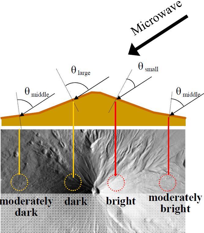
 of the depression angle (γ).")
15 Radar Geometry The incidence angle is the angle between the radar pulse of EMR and a line perpendicular to the Earth s surface where it makes contact. When the terrain is flat, the incidence angle is the complement ( 90 - γ) of the depression angle (γ).
16 Van Zyl, J. and Kim, Y Contd
17 Contd The aircraft travels in a straight line that is called the azimuth flight direction. Pulses of active microwave electromagnetic energy illuminate strips of the terrain at right angles (orthogonal) to the aircraft s direction of travel, which is called the range. The terrain illuminated nearest the aircraft in the line of sight is called the near-range. The farthest point of terrain illuminated by the pulse of energy is called the far-range. The depression angle (γ) is the angle between a horizontal plane extending out from the aircraft fuselage and the electromagnetic pulse of energy from the antenna to a specific point on the ground.
18 Incidence Angle and Local Incidence Angle
19 Synthetic Aperture Radar
20 Contd
21 Ground Swath Width φ i= Mean Incidencenc Angle
22 SAR Resolution Azimuth Resolution- Azimuth resolution describes the ability of an imaging radar to separate two closely spaced scatterers in the direction parallel to the motion vector of the sensor. Range Resolution- For the radar to be able to distinguish two closely spaced elements, their echoes must necessarily be received at different times.

23 Azimuth Resolution Angular horizontal beam width of a real-aperture radar is: where L is antenna length and λ is wavelength Horizontal beam width of the synthetic aperture Azimuth resolution is simply the product of the effective horizontal beam width and the slant-range distance to the target

24 Azimuth Resolution and Antenna Length Objective: To get 1 m azimuth resolution with 20 KM range distance Beam width β H = 5* For X-band systems (wavelength 0.03 m) Antenna length L = λ/2 β H = 300 m

25 Range Resolution Range resolution is the minimum range difference for which two point targets are recognized as two, rather than being grouped together as one target. A well-designed radar system, with all other factors at maximum efficiency, should be able to distinguish targets separated by one-half the pulse width time τ.

26 Contd
27 The figure shows two types of radar data display: - slant range image, in which distances are measured between the antenna and the target. - ground range image, in which distances are measured between the platform ground track and the target, Slant Range / Ground Range
, the electrical")
28 SAR data consist of highresolution reflected returns of radar-frequency energy from terrain that has been illuminated by a directed beam of pulses generated by the sensor. The radar returns from the terrain are mainly determined by the physical characteristics of the surface features (such as surface roughness, geometric structure, and orientation), the electrical characteristics (dielectric constant, moisture content, and conductivity), and the radar frequency of the sensor. SAR DATA TerraSAR-x Vishakhapattanam
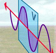
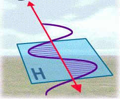
29 Radar Polarisation Un-polarized energy vibrates in all possible directions perpendicular to the direction of travel. Radar antennas send and receive polarized energy. This means that the pulse of energy is filtered so that its electrical wave vibrations are only in a single plane that is perpendicular to the direction of travel. The pulse of electromagnetic energy sent out by the antenna may be vertically or horizontally polarized.
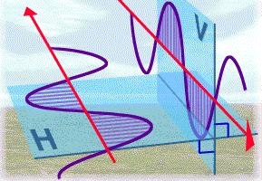
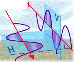
30 Polarisations
31 SAR Modes Stripmap Spotlight Scan Mode
32 Geometric Distortions in RADAR Foreshortening When the radar beam reaches the base of a tall feature tilted towards the radar (e.g. a mountain) before it reaches the top foreshortening will occur. the slope (A to B) will appear compressed and the length of the slope will be represented incorrectly (A' to B').

33 The figure shows a radar image of steep mountainous terrain with severe foreshortening effects. The foreshortened slopes appear as bright features on the image. CONTD
34 Layover occurs when the radar beam reaches the top of a tall feature (B) before it reaches the base (A). The return signal from the top of the feature will be received before the signal from the bottom. As a result, the top of the feature is displaced towards the radar from its true position on the ground, and "lays over" the base of the feature (B to A') Layover

35 Layover effects on a radar image look very similar to effects due to foreshortening. Layover displacement is greatest at short range, where the look angle is smaller. CONTD
, behind vertical features or slopes with steep sides.")
36 Both foreshortening and layover result in radar shadow. Radar shadow occurs when the radar beam is not able to illuminate the ground surface. Shadows occur in the down range dimension (i.e. towards the far range), behind vertical features or slopes with steep sides. Shadow

37 Radar shadow effects CONTD
38 Shadows Measurement of Object Height The simplest method of measuring object height is to observe the length, L,of the shadow of the object by the SAR and calculate the object height from the known SAR altitude, H and ground range, R,:
39 Specular Versus Diffuse Reflectance
40 Surface roughness There is a relationship between the wavelength of the radar (λ), the depression angle (γ), and the local height of objects (h in cm) found within the resolution cell being illuminated by microwave energy. It is called the modified Rayleigh criteria and can be used to predict what the earth's surface will look like in a radar image if we know the surface roughness characteristics and the radar system parameters (λ, γ, h) mentioned.

41 Smooth and Rough Rayleigh Criteria The area with smooth surface roughness sends back very little backscatter toward the antenna, i.e. it acts like a specular reflecting surface where most of the energy bounces off the terrain away from the antenna. The small amount of back-scattered energy returned to the antenna is recorded and shows up as a dark area on the radar image. The quantitative expression of the smooth criteria is:
42 Smooth and Rough Rayleigh Criteria The area with smooth surface roughness sends back very little backscatter toward the antenna, i.e. it acts like a specular reflecting surface where most of the energy bounces off the terrain away from the antenna. The small amount of back-scattered energy returned to the antenna is recorded and shows up as a dark area on the radar image. The quantitative expression of the smooth criteria is: A bright return is expected if the modified Rayleigh rough criteria are used:

43 Peake and Oliver's modified Rayleigh criterion
44 Radar Backscatter and Incidence Angle
45 Local Incidence Angle
46 Radar Return as a Function of Geometric Properties of Object
47 Interaction of EM Wave with Soil Dry Soil: Some of the incident radar energy is able to penetrate into the soil surface, resulting in less backscattered intensity. Wet Soil: The large difference in electrical properties between water and air results in higher backscattered radar intensity. Flooded Soil: Radar is specularly reflected off the water surface, resulting in low backscattered intensity. The flooded area appears dark in the SAR image.
48 Volume Scattering Volume scattering is related to multiple scattering processes within a medium, such as the vegetation canopy of a corn field or a forest. The intensity of volume scattering depends on the physical properties of the volume (variations in dielectric constant, in particular) and the characteristics of the radar (wavelength, polarization and incident angle

49 Response of a Pine Forest Stand To X-, C- and L- band Microwave Energy

 within the corresponding resolution cell projected on the ground. Complex SAR Image (0.587161,-0.")
50 SAR image pixel is associated with a small area of the Earth s surface (called a resolution cell). Each pixel gives a complex number that carries amplitude and phase information about the microwave field backscattered by all the scatterers (rocks, vegetation, buildings etc.) within the corresponding resolution cell projected on the ground. Complex SAR Image ( , ) RADARSAT-2 SLC data for San Francisco area (HH Channel)
51 Speckle A SAR resolution cell generally contains a large number of scatterers and in comparison to the wavelength this resolution cell appears very large. The returned echo from scatterers is coherently summed to obtain the phase and brightness of the resolution cell. Sometimes due to a very strong reflector at a particular alignment or due to the coherent sum of all the various responses (due to large number of scattereres), the resolution cell shows a brightness value which is much higher than the actual brightness caused by the object. This unexpected bright value of resolution cell appears as speckle on SAR image.
52 SAR Data Format Raw Data SLC Data Multi-look Data Geocoded Data Polarimetric Data
53 SAR Applications SAR interferometry for DEM generation; SAR interferometry for subsident monitoring; SAR for soil moisture content; SAR for biomass estimation; SAR for crop estimation; SAR for flood control; SAR for oil spills monitoring.
54 SAR for DEM Generation Two technology can be applied to generate DEM (Stereo SAR and Interferometric SAR); Stereo SAR uses the parallax of SAR pair to generate DEM; Interferometric SAR uses the deferent phases of two SAR images to estimate the surface height; A DEM for a large area can be generated without need of ground control or a few control points.
55 SAR Interferometry For Subsidence Monitoring DiInSAR technology is used; The millimeters level of accuracy can be obtained. This technology is good for monitoring the construction site such as mining area, city... It can help in predicting the hazards such as mining exploitation.
56 SAR Application for Soil Moisture Content Estimation Soil dielectric constant is calculated through the SAR backscattering signals; The soil moisture content can be estimated by the soil dielectric constant; The accuracy of the estimated result depend on the SAR wavelength, the polarization used; It is useful for irrigation monitoring as well as the environmental monitoring.
57 SAR for Biomass Estimation Combine two separate SAR technologies, SAR polarimetry and Interferometry. SAR polarimetry uses the polarization state of receiving and transmitting channel to measure the differences in backscatter due to orientation, shape and material composition; SAR interferometry coherently combines signals from two separated spatial positions to extract the interferogram; By combining two technologies, the vegetation propertied such as vegetation height and biomass can be determined.
58 SAR for Crop Estimation Multi-temporal SAR data should be used to monitor the plant grow and estimate the plant s biomass; The damages area due to Flooding can also be monitoring; The crop producing model may be used to simulate the plant grow and predict the crop yields.
59 SAR for Flood Control SAR data is weather independent; It can be obtain in before, during, and after the flood event; The flood area can be mapped; The flood movement can be delineated; The flood effect area can be mapped.

60 Pauli RGB Image HH+VV Blue Colour HH-VV Red Colour 2HV Green Colour


61 Forest of Doon valley Dudhwa National Park, U.P. Sunderban, W.B. Decomposition modelling of ALOS PALSAR QuadPol data PolSAR Decomposition
62 (HV) Backscattering Coefficients and Biomass RAMSES P-band Data over Nezer Forest
63 SAR for Oil Spills Monitoring The SAR data is cloud independent; Oil cover surface is clearly displayed in SAR images as dark regions; Some software can detect oil spills automatically The thickness of the oil layer may also be obtained using SAR data; With the multi-temporal data available, the source of pollution may be discovered.

64 Envisat Images Source:-Solberg, et al. 2007

65 Thank You
Microwave Remote Sensing (1)
") Microwave Remote Sensing (1) Microwave sensing encompasses both active and passive forms of remote sensing. The microwave portion of the spectrum covers the range from approximately 1cm to 1m in wavelength.
Microwave Remote Sensing (1) Microwave sensing encompasses both active and passive forms of remote sensing. The microwave portion of the spectrum covers the range from approximately 1cm to 1m in wavelength.
Remote Sensing. Ch. 3 Microwaves (Part 1 of 2)
") Remote Sensing Ch. 3 Microwaves (Part 1 of 2) 3.1 Introduction 3.2 Radar Basics 3.3 Viewing Geometry and Spatial Resolution 3.4 Radar Image Distortions 3.1 Introduction Microwave (1cm to 1m in wavelength)
Remote Sensing Ch. 3 Microwaves (Part 1 of 2) 3.1 Introduction 3.2 Radar Basics 3.3 Viewing Geometry and Spatial Resolution 3.4 Radar Image Distortions 3.1 Introduction Microwave (1cm to 1m in wavelength)
ACTIVE SENSORS RADAR
 ACTIVE SENSORS RADAR RADAR LiDAR: Light Detection And Ranging RADAR: RAdio Detection And Ranging SONAR: SOund Navigation And Ranging Used to image the ocean floor (produce bathymetic maps) and detect objects
Introduction Active microwave Radar
 RADAR Imaging Introduction 2 Introduction Active microwave Radar Passive remote sensing systems record electromagnetic energy that was reflected or emitted from the surface of the Earth. There are also
Synthetic aperture RADAR (SAR) principles/instruments October 31, 2018
 principles/instruments October 31, 2018") GEOL 1460/2461 Ramsey Introduction to Remote Sensing Fall, 2018 Synthetic aperture RADAR (SAR) principles/instruments October 31, 2018 I. Reminder: Upcoming Dates lab #2 reports due by the start of next
GEOL 1460/2461 Ramsey Introduction to Remote Sensing Fall, 2018 Synthetic aperture RADAR (SAR) principles/instruments October 31, 2018 I. Reminder: Upcoming Dates lab #2 reports due by the start of next
Introduction to Radar
 National Aeronautics and Space Administration ARSET Applied Remote Sensing Training http://arset.gsfc.nasa.gov @NASAARSET Introduction to Radar Jul. 16, 2016 www.nasa.gov Objective The objective of this
Review. Guoqing Sun Department of Geography, University of Maryland ABrief
 Review Guoqing Sun Department of Geography, University of Maryland gsun@glue.umd.edu ABrief Introduction Scattering Mechanisms and Radar Image Characteristics Data Availability Example of Applications
EE 529 Remote Sensing Techniques. Introduction
 EE 529 Remote Sensing Techniques Introduction Course Contents Radar Imaging Sensors Imaging Sensors Imaging Algorithms Imaging Algorithms Course Contents (Cont( Cont d) Simulated Raw Data y r Processing
Microwave Remote Sensing
 Provide copy on a CD of the UCAR multi-media tutorial to all in class. Assign Ch-7 and Ch-9 (for two weeks) as reading material for this class. HW#4 (Due in two weeks) Problems 1,2,3 and 4 (Chapter 7)
RADAR (RAdio Detection And Ranging)
") RADAR (RAdio Detection And Ranging) CLASSIFICATION OF NONPHOTOGRAPHIC REMOTE SENSORS PASSIVE ACTIVE DIGITAL CAMERA THERMAL (e.g. TIMS) VIDEO CAMERA MULTI- SPECTRAL SCANNERS VISIBLE & NIR MICROWAVE Real
RADAR (RAdio Detection And Ranging) CLASSIFICATION OF NONPHOTOGRAPHIC REMOTE SENSORS PASSIVE ACTIVE DIGITAL CAMERA THERMAL (e.g. TIMS) VIDEO CAMERA MULTI- SPECTRAL SCANNERS VISIBLE & NIR MICROWAVE Real
RADAR REMOTE SENSING
 RADAR REMOTE SENSING Jan G.P.W. Clevers & Steven M. de Jong Chapter 8 of L&K 1 Wave theory for the EMS: Section 1.2 of L&K E = electrical field M = magnetic field c = speed of light : propagation direction
CEGEG046 / GEOG3051 Principles & Practice of Remote Sensing (PPRS) 8: RADAR 1
 8: RADAR 1") CEGEG046 / GEOG3051 Principles & Practice of Remote Sensing (PPRS) 8: RADAR 1 Dr. Mathias (Mat) Disney UCL Geography Office: 113, Pearson Building Tel: 7670 05921 Email: mdisney@ucl.geog.ac.uk www.geog.ucl.ac.uk/~mdisney
CEGEG046 / GEOG3051 Principles & Practice of Remote Sensing (PPRS) 8: RADAR 1 Dr. Mathias (Mat) Disney UCL Geography Office: 113, Pearson Building Tel: 7670 05921 Email: mdisney@ucl.geog.ac.uk www.geog.ucl.ac.uk/~mdisney
Acknowledgment. Process of Atmospheric Radiation. Atmospheric Transmittance. Microwaves used by Radar GMAT Principles of Remote Sensing
 GMAT 9600 Principles of Remote Sensing Week 4 Radar Background & Surface Interactions Acknowledgment Mike Chang Natural Resources Canada Process of Atmospheric Radiation Dr. Linlin Ge and Prof Bruce Forster
10 Radar Imaging Radar Imaging
 10 Radar Imaging Active sensors provide their own source of energy to illuminate the target. Active sensors are generally divided into two distinct categories: imaging and non-imaging. The most common
Synthetic Aperture Radar
 Synthetic Aperture Radar Picture 1: Radar silhouette of a ship, produced with the ISAR-Processor of the Ocean Master A Synthetic Aperture Radar (SAR), or SAR, is a coherent mostly airborne or spaceborne
MODULE 9 LECTURE NOTES 2 ACTIVE MICROWAVE REMOTE SENSING
 MODULE 9 LECTURE NOTES 2 ACTIVE MICROWAVE REMOTE SENSING 1. Introduction Satellite sensors are capable of actively emitting microwaves towards the earth s surface. An active microwave system transmits
Radar Imaging Wavelengths
 A Basic Introduction to Radar Remote Sensing ~~~~~~~~~~ Rev. Ronald J. Wasowski, C.S.C. Associate Professor of Environmental Science University of Portland Portland, Oregon 3 November 2015 Radar Imaging
ACTIVE MICROWAVE REMOTE SENSING OF LAND SURFACE HYDROLOGY
 Basics, methods & applications ACTIVE MICROWAVE REMOTE SENSING OF LAND SURFACE HYDROLOGY Annett.Bartsch@polarresearch.at Active microwave remote sensing of land surface hydrology Landsurface hydrology:
Active and Passive Microwave Remote Sensing
 Active and Passive Microwave Remote Sensing Passive remote sensing system record EMR that was reflected (e.g., blue, green, red, and near IR) or emitted (e.g., thermal IR) from the surface of the Earth.
Synthetic Aperture Radar for Rapid Flood Extent Mapping
 National Aeronautics and Space Administration ARSET Applied Remote Sensing Training http://arset.gsfc.nasa.gov @NASAARSET Synthetic Aperture Radar for Rapid Flood Extent Mapping Sang-Ho Yun ARIA Team Jet
SAR Remote Sensing. Introduction into SAR. Data characteristics, challenges, and applications.
 SAR Remote Sensing Introduction into SAR. Data characteristics, challenges, and applications. PD Dr. habil. Christian Thiel, Friedrich-Schiller-University Jena DLR-HR Jena & Friedrich-Schiller-University
All rights reserved. ENVI, IDL and Jagwire are trademarks of Exelis, Inc. All other marks are the property of their respective owners.
 SAR Analysis Made Easy with SARscape 5.1 All rights reserved. ENVI, IDL and Jagwire are trademarks of Exelis, Inc. All other marks are the property of their respective owners. 2014, Exelis Visual Information
SAR Multi-Temporal Applications
 SAR Multi-Temporal Applications 83230359-DOC-TAS-EN-001 Contents 2 Advantages of SAR Remote Sensing Technology All weather any time Frequencies and polarisations Interferometry and 3D mapping Change Detection
Introduction to Imaging Radar INF-GEO 4310
 Introduction to Imaging Radar INF-GEO 4310 22.9.2011 Literature Contact: yoann.paichard@ffi.no Suggested readings: Fundamentals of Radar Signal Processing, M.A. Richards, McGraw-Hill, 2005 High Resolution
Microwave remote sensing. Rudi Gens Alaska Satellite Facility Remote Sensing Support Center
 Microwave remote sensing Alaska Satellite Facility Remote Sensing Support Center 1 Remote Sensing Fundamental The entire range of EM radiation constitute the EM Spectrum SAR sensors sense electromagnetic
SAR Imagery: Airborne or Spaceborne? Presenter: M. Lorraine Tighe PhD
 SAR Imagery: Airborne or Spaceborne? Presenter: M. Lorraine Tighe PhD Introduction The geospatial community has seen a plethora of spaceborne SAR imagery systems where there are now extensive archives
SARscape Modules for ENVI
 Visual Information Solutions SARscape Modules for ENVI Read, process, analyze, and output products from SAR data. ENVI. Easy to Use Tools. Proven Functionality. Fast Results. DEM, based on TerraSAR-X-1
Active and Passive Microwave Remote Sensing
 Active and Passive Microwave Remote Sensing Passive remote sensing system record EMR that was reflected (e.g., blue, green, red, and near IR) or emitted (e.g., thermal IR) from the surface of the Earth.
Imaging radar Imaging radars provide map-like coverage to one or both sides of the aircraft.
 CEE 6100 / CSS 6600 Remote Sensing Fundamentals 1 Imaging radar Imaging radars provide map-like coverage to one or both sides of the aircraft. Acronyms: RAR real aperture radar ("brute force", "incoherent")
Specificities of Near Nadir Ka-band Interferometric SAR Imagery
 Specificities of Near Nadir Ka-band Interferometric SAR Imagery Roger Fjørtoft, Alain Mallet, Nadine Pourthie, Jean-Marc Gaudin, Christine Lion Centre National d Etudes Spatiales (CNES), France Fifamé
Synthetic Aperture Radar Interferometry (InSAR) Technique (Lecture I- Tuesday 11 May 2010)
 Technique (Lecture I- Tuesday 11 May 2010)") Synthetic Aperture Radar Interferometry () Technique (Lecture I- Tuesday 11 May 2010) ISNET/CRTEAN Training Course on Synthetic Aperture Radar (SAR) Imagery: Processing, Interpretation and Applications
Synthetic Aperture Radar Interferometry () Technique (Lecture I- Tuesday 11 May 2010) ISNET/CRTEAN Training Course on Synthetic Aperture Radar (SAR) Imagery: Processing, Interpretation and Applications
Introduction to Microwave Remote Sensing
 Introduction to Microwave Remote Sensing lain H. Woodhouse The University of Edinburgh Scotland Taylor & Francis Taylor & Francis Group Boca Raton London New York A CRC title, part of the Taylor & Francis
SARscape for ENVI. A Complete SAR Analysis Solution
 SARscape for ENVI A Complete SAR Analysis Solution IDL and ENVI A Foundation for SARscape IDL The Data Analysis & Visualization Platform Data Access: IDL supports virtually every data format, type and
School of Rural and Surveying Engineering National Technical University of Athens
 Laboratory of Photogrammetry National Technical University of Athens Combined use of spaceborne optical and SAR data Incompatible data sources or a useful procedure? Charalabos Ioannidis, Dimitra Vassilaki
SAOCOM-CS Mission and ESA Airborne Campaign Data
 SAOCOM-CS Mission and ESA Airborne Campaign Data Malcolm Davidson Head of the EOP Campaign Section Malcolm.Davidson@esa.int Objectives of presentation Introduce a new type of ESA SAR mission with Polarimetrice,
MULTI-CHANNEL SAR EXPERIMENTS FROM THE SPACE AND FROM GROUND: POTENTIAL EVOLUTION OF PRESENT GENERATION SPACEBORNE SAR
 3 nd International Workshop on Science and Applications of SAR Polarimetry and Polarimetric Interferometry POLinSAR 2007 January 25, 2007 ESA/ESRIN Frascati, Italy MULTI-CHANNEL SAR EXPERIMENTS FROM THE
SATELLITE OCEANOGRAPHY
 SATELLITE OCEANOGRAPHY An Introduction for Oceanographers and Remote-sensing Scientists I. S. Robinson Lecturer in Physical Oceanography Department of Oceanography University of Southampton JOHN WILEY
Remote Sensing 1 Principles of visible and radar remote sensing & sensors
 Remote Sensing 1 Principles of visible and radar remote sensing & sensors Nick Barrand School of Geography, Earth & Environmental Sciences University of Birmingham, UK Field glaciologist collecting data
Principles of Remote Sensing. Shuttle Radar Topography Mission S R T M. Michiel Damen. Dept. Earth Systems Analysis
 Principles of Remote Sensing Shuttle Radar Topography Mission S R T M Michiel Damen Dept. Earth Systems Analysis Contents Present problems with DEMs Advantage of SRTM Cell size Mission and system Radar
ESA Radar Remote Sensing Course ESA Radar Remote Sensing Course Radar, SAR, InSAR; a first introduction
 Radar, SAR, InSAR; a first introduction Ramon Hanssen Delft University of Technology The Netherlands r.f.hanssen@tudelft.nl Charles University in Prague Contents Radar background and fundamentals Imaging
ANALYSIS OF SRTM HEIGHT MODELS
 ANALYSIS OF SRTM HEIGHT MODELS Sefercik, U. *, Jacobsen, K.** * Karaelmas University, Zonguldak, Turkey, ugsefercik@hotmail.com **Institute of Photogrammetry and GeoInformation, University of Hannover,
SENTINEL-1 Toolbox. Polarimetric Tutorial Issued March 2015 Updated August Luis Veci
 SENTINEL-1 Toolbox Polarimetric Tutorial Issued March 2015 Updated August 2016 Luis Veci Copyright 2015 Array Systems Computing Inc. http://www.array.ca/ http://step.esa.int Polarimetric Tutorial The goal
The Radar Ortho Suite is an add-on to Geomatica. It requires Geomatica Core or Geomatica Prime as a pre-requisite.
 Technical Specifications Radar Ortho Suite The Radar Ortho Suite includes rigorous and rational function models developed to compensate for distortions and produce orthorectified radar images. Distortions
Contribution of Sentinel-1 data for the monitoring of seasonal variations of the vegetation
 Contribution of Sentinel-1 data for the monitoring of seasonal variations of the vegetation P.-L. Frison, S. Kmiha, B. Fruneau, K. Soudani, E. Dufrêne, T. Koleck, L. Villard, M. Lepage, J.-F. Dejoux, J.-P.
Detection of a Point Target Movement with SAR Interferometry
 Journal of the Korean Society of Remote Sensing, Vol.16, No.4, 2000, pp.355~365 Detection of a Point Target Movement with SAR Interferometry Jung-Hee Jun* and Min-Ho Ka** Agency for Defence Development*,
RADAR INTERFEROMETRY FOR SAFE COAL MINING IN CHINA
 RADAR INTERFEROMETRY FOR SAFE COAL MINING IN CHINA L. Ge a, H.-C. Chang a, A. H. Ng b and C. Rizos a Cooperative Research Centre for Spatial Information School of Surveying & Spatial Information Systems,
SCATTERING POLARIMETRY PART 1. Dr. A. Bhattacharya (Slide courtesy Prof. E. Pottier and Prof. L. Ferro-Famil)
") SCATTERING POLARIMETRY PART 1 Dr. A. Bhattacharya (Slide courtesy Prof. E. Pottier and Prof. L. Ferro-Famil) 2 That s how it looks! Wave Polarisation An electromagnetic (EM) plane wave has time-varying
SCATTERING POLARIMETRY PART 1 Dr. A. Bhattacharya (Slide courtesy Prof. E. Pottier and Prof. L. Ferro-Famil) 2 That s how it looks! Wave Polarisation An electromagnetic (EM) plane wave has time-varying
Soil moisture retrieval using ALOS PALSAR
 Soil moisture retrieval using ALOS PALSAR T. J. Jackson, R. Bindlish and M. Cosh USDA ARS Hydrology and Remote Sensing Lab, Beltsville, MD J. Shi University of California Santa Barbara, CA November 6,
Earth Observation and Sensing Technologies: a focus on Radar Imaging Developments. Riccardo Lanari
 Earth Observation and Sensing Technologies: a focus on Radar Imaging Developments Riccardo Lanari Institute for Electromagnetic Sensing of the Environment (IREA) National Research Council of Italy (CNR)
ASAR Training Course, Hanoi, 25 February 7 March 2008 Introduction to Radar Interferometry
 Introduction to Radar Interferometry Presenter: F.Sarti (ESA/ESRIN) 1 Imaging Radar : reminder 2 Physics of radar Potentialities of radar All-weather observation system (active system) Penetration capabilities
Interpreting Digital RADAR Images
 R A D A R Introduction to Interpreting Digital Radar Images I N T E R P R E T Interpreting Digital RADAR Images with TNTmips page 1 Before Getting Started Airborne and satellite radar systems are versatile
THE NASA/JPL AIRBORNE SYNTHETIC APERTURE RADAR SYSTEM. Yunling Lou, Yunjin Kim, and Jakob van Zyl
 THE NASA/JPL AIRBORNE SYNTHETIC APERTURE RADAR SYSTEM Yunling Lou, Yunjin Kim, and Jakob van Zyl Jet Propulsion Laboratory California Institute of Technology 4800 Oak Grove Drive, MS 300-243 Pasadena,
Overview Research and Projects
 Overview Research and Projects Alberto Moreira Microwaves and Radar Institute (HR) Microwaves and Radar Institute Research Profile: passive and active microwave systems Sensor concept, design and simulation
Introduction to RADAR Remote Sensing for Vegetation Mapping and Monitoring. Wayne Walker, Ph.D.
 Introduction to RADAR Remote Sensing for Vegetation Mapping and Monitoring Wayne Walker, Ph.D. Outline What is RADAR (and what does it measure)? RADAR as an active sensor Applications of RADAR to vegetation
remote sensing? What are the remote sensing principles behind these Definition
 Introduction to remote sensing: Content (1/2) Definition: photogrammetry and remote sensing (PRS) Radiation sources: solar radiation (passive optical RS) earth emission (passive microwave or thermal infrared
European Space Agency and IPY
 European Space Agency and IPY ESA supports IPY 2007-2008 activities: First ESA step was a dedicated Announcement Opportunity (AO) for EO data provision in support IPY, released in 2006, with data provision
Dynamics and Control Issues for Future Multistatic Spaceborne Radars
 Dynamics and Control Issues for Future Multistatic Spaceborne Radars Dr Stephen Hobbs Space Research Centre, School of Engineering, Cranfield University, UK Abstract Concepts for future spaceborne radar
Exploring the Potential Pol-InSAR Techniques at X-Band: First Results & Experiments from TanDEM-X
 Exploring the Potential Pol-InSAR Techniques at X-Band: First Results & Experiments from TanDEM-X K. Papathanassiou, F. Kugler, J-S. Kim, S-K. Lee, I. Hajnsek Microwaves and Radar Institute (DLR-HR) German
RESERVOIR MONITORING USING RADAR SATELLITES
 RESERVOIR MONITORING USING RADAR SATELLITES Alain Arnaud, Johanna Granda, Geraint Cooksley ALTAMIRA INFORMATION S.L., Calle Córcega 381-387, E-08037 Barcelona, Spain. Key words: Reservoir monitoring, InSAR,
746A27 Remote Sensing and GIS
 746A27 Remote Sensing and GIS Lecture 1 Concepts of remote sensing and Basic principle of Photogrammetry Chandan Roy Guest Lecturer Department of Computer and Information Science Linköping University What
Co-ReSyF RA lecture: Vessel detection and oil spill detection
 This project has received funding from the European Union s Horizon 2020 Research and Innovation Programme under grant agreement no 687289 Co-ReSyF RA lecture: Vessel detection and oil spill detection
Radar Polarimetry- Potential for Geosciences
 Radar Polarimetry- Potential for Geosciences Franziska Kersten Department of geology, TU Freiberg Abstract. The ability of Radar Polarimetry to obtain information about physical properties of the surface
Environmental Impact Assessment of Mining Subsidence by Using Spaceborne Radar Interferometry
 Environmental Impact Assessment of Mining Subsidence by Using Spaceborne Radar Interferometry Hsing-Chung CHANG, Linlin GE and Chris RIZOS, Australia Key words: Mining Subsidence, InSAR, DInSAR, DEM. SUMMARY
Remote sensing radio applications/ systems for environmental monitoring
 Remote sensing radio applications/ systems for environmental monitoring Alexandre VASSILIEV ITU Radiocommunication Bureau phone: +41 22 7305924 e-mail: alexandre.vassiliev@itu.int 1 Source: European Space
CNES PRIORITIES IN POLAR AND CRYOSPHERE RESEARCH
 Polar Space Task Group 3rd Session CNES PRIORITIES IN POLAR AND CRYOSPHERE RESEARCH Juliette Lambin, Steven Hosford Wednesday, May 22th, 2013 Paris, France 1 OUTLINE CNES MISSIONS FOR POLAR/CRYOSPHERE
RADARSAT-2 Program Update Daniel De Lisle Canadian Space Agency
 RADARSAT-2 Program Update Daniel De Lisle Canadian Space Agency Presentation outline RADARSAT-1 Update RADARSAT-2 Mission description Mission Objectives System Characteristics Data Commercialization/Allocation
Govt. Engineering College Jhalawar Model Question Paper Subject- Remote Sensing & GIS
 Govt. Engineering College Jhalawar Model Question Paper Subject- Remote Sensing & GIS Time: Max. Marks: Q1. What is remote Sensing? Explain the basic components of a Remote Sensing system. Q2. What is
Playa del Rey, California InSAR Ground Deformation Monitoring Interim Report H
 Playa del Rey, California InSAR Ground Deformation Monitoring Interim Report H Ref.: RV-14524 Doc.: CM-168-01 January 31, 2013 SUBMITTED TO: Southern California Gas Company 555 W. Fifth Street (Mail Location
SARscape 4.1 Supported Sensors/Products (October 2008)
") SARscape 4.1 Supported Sensors/Products (October 2008) ALOS PALSAR (provided by JAXA) In case of RAW (level 1.0) data, import is carried out within the Focusing Module. PALSAR RAW data in CEOS standard
SARscape 4.1 Supported Sensors/Products (October 2008) ALOS PALSAR (provided by JAXA) In case of RAW (level 1.0) data, import is carried out within the Focusing Module. PALSAR RAW data in CEOS standard
Sub-Mesoscale Imaging of the Ionosphere with SMAP
 Sub-Mesoscale Imaging of the Ionosphere with SMAP Tony Freeman Xiaoqing Pi Xiaoyan Zhou CEOS Workshop, ASF, Fairbanks, Alaska, December 2009 1 Soil Moisture Active-Passive (SMAP) Overview Baseline Mission
Application Potential of Planned SAR Satellites a Preview
 PREPRINT/PRÉTIRAGE Application Potential of Planned SAR Satellites a Preview J.J. van der Sanden 1, P. Budkewitsch 1, R. Landry 1, M.J. Manore 2, H. McNairn 1, T.J. Pultz 1, and P.W. Vachon 1 1 Canada
Remote Sensing ISSN
 Remote Sens. 2013, 5, 716-807; doi:10.3390/rs5020716 OPEN ACCESS Remote Sensing ISSN 2072-4292 www.mdpi.com/journal/remotesensing Review Recent Trend and Advance of Synthetic Aperture Radar with Selected
TerraSAR-X Applications Guide
 TerraSAR-X Applications Guide Extract: Change Detection and Monitoring: Geospatial / Image Intelligence April 2015 Airbus Defence and Space Geo-Intelligence Programme Line Change Detection and Monitoring:
Outline. Introduction. Introduction: Film Emulsions. Sensor Systems. Types of Remote Sensing. A/Prof Linlin Ge. Photographic systems (cf(
 GMAT x600 Remote Sensing / Earth Observation Types of Sensor Systems (1) Outline Image Sensor Systems (i) Line Scanning Sensor Systems (passive) (ii) Array Sensor Systems (passive) (iii) Antenna Radar
Figure 1: C band and L band (SIR-C/X-SAR images of Flevoland in Holland). color scheme: HH: red, HV:green, VV: blue
. color scheme: HH: red, HV:green, VV: blue") L-band PS analysis: JERS-1 results and TerraSAR L predictions Kenji Daito (1), Alessandro Ferretti (), Shigeki Kuzuoka (3),Fabrizio Novali (), Pietro Panzeri (), Fabio Rocca (4) (1) Daido Institute of
L-band PS analysis: JERS-1 results and TerraSAR L predictions Kenji Daito (1), Alessandro Ferretti (), Shigeki Kuzuoka (3),Fabrizio Novali (), Pietro Panzeri (), Fabio Rocca (4) (1) Daido Institute of
Francesco Holecz. TUBE II meeting - 17 June Land Degradation. Land Degradation
 Land Degradation Francesco Holecz Objective To identify and monitor land degraded areas, in particular those related to agricultural and pastoral activities. Following products are generated: Land cover
Microwave sensors (present and future)
") Proc. Indian Acad. Sci. (Engg. sea.), Vol. 6, Pt. 2, June 1983, pp. 109-119. 9 Printed in India. Microwave sensors (present and future) 1. Introduction O P N CALLA Communications Area, Space Applications
Proc. Indian Acad. Sci. (Engg. sea.), Vol. 6, Pt. 2, June 1983, pp. 109-119. 9 Printed in India. Microwave sensors (present and future) 1. Introduction O P N CALLA Communications Area, Space Applications
Introduction to radar. interferometry
 Introduction to radar Introduction to Radar Interferometry interferometry Presenter: F.Sarti (ESA/ESRIN) With kind contribution by the Radar Department of CNES All-weather observation system (active system)
Radar and Satellite Remote Sensing. Chris Allen, Associate Director Technology Center for Remote Sensing of Ice Sheets The University of Kansas
 Radar and Satellite Remote Sensing Chris Allen, Associate Director Technology Center for Remote Sensing of Ice Sheets The University of Kansas 2of 43 Outline Background ice sheet characterization Radar
PALSAR SCANSAR SCANSAR Interferometry
 PALSAR SCANSAR SCANSAR Interferometry Masanobu Shimada Japan Aerospace Exploration Agency Earth Observation Research Center ALOS PI symposium, Greece Nov. 6 2008 1 Introduction L-band PALSAR strip mode
Copernicus Introduction Lisbon, Portugal 13 th & 14 th February 2014
 Copernicus Introduction Lisbon, Portugal 13 th & 14 th February 2014 Contents Introduction GMES Copernicus Six thematic areas Infrastructure Space data An introduction to Remote Sensing In-situ data Applications
Radar remote sensing from space for monitoring deformations affecting urban areas and infrastructures
 Radar remote sensing from space for monitoring deformations affecting urban areas and infrastructures Riccardo Lanari IREA-CNR Napoli EGU2014, Vienna 30 April, 2014 Why Radar (SAR) Imaging from space?
SAR Training Course, MCST, Kalkara, Malta, November SAR Maritime Applications. History and Basics
 SAR Maritime Applications History and Basics Martin Gade Uni Hamburg, Institut für Meereskunde SAR Maritime Applications Thursday, 13 Nov.: 1 - History & Basics Introduction Radar/SAR History Basics Scatterometer
ERS/ENVISAT ASAR Data Products and Services
 ERS/ENVISAT ASAR Data Products and Services Andrea Celentano Business Manager celentan@eurimage.com What is Eurimage? Founded in 1989 Current shareholders: Since 1989 Commercial Partner of the European
7.7 TerraSAR-X & TanDEM-X
 7.7 TerraSAR-X & TanDEM-X Two Innovative Remote Sensing Stars for space-borne Earth Observation Vorlesung Wolfgang Keydel Microwaves and Radar Institute, German Aerospace Research Center (DLR), D-82230
Active microwave systems (1) Satellite Altimetry
 Satellite Altimetry") Remote Sensing: John Wilkin Active microwave systems (1) Satellite Altimetry jwilkin@rutgers.edu IMCS Building Room 214C 732-932-6555 ext 251 Active microwave instruments Scatterometer (scattering from
Remote Sensing: John Wilkin Active microwave systems (1) Satellite Altimetry jwilkin@rutgers.edu IMCS Building Room 214C 732-932-6555 ext 251 Active microwave instruments Scatterometer (scattering from
Change detection in cultural landscapes
 9-11 November 2015 ESA-ESRIN, Frascati (Rome), Italy 3 rd ESA-EARSeL Course on Remote Sensing for Archaeology Day 3 Change detection in cultural landscapes DeodatoTapete (1,2) & Francesca Cigna (1,2) (1)
LE/ESSE Payload Design
 LE/ESSE4360 - Payload Design 3.2 Spacecraft Sensors Introduction to Sensors Earth, Moon, Mars, and Beyond Dr. Jinjun Shan, Professor of Space Engineering Department of Earth and Space Science and Engineering
The Current Status and Brief Results of Engineering Model for PALSAR-2 onboard ALOS-2 and Science Project
 The Current Status and Brief Results of Engineering Model for PALSAR-2 onboard ALOS-2 and Science Project + The 16 th KC meeting Japan Aerospace Exploration Agency Masanobu Shimada, Yukihiro KANKAKU The
Fundamentals of Remote Sensing: SAR Interferometry
 INSIS Fundamentals of Remote Sensing: SAR Interferometry Notions fondamentales de télédétection : l interférométrie RSO Gabriel VASILE Chargé de Recherche CNRS gabriel.vasile@gipsa-lab.grenoble-inp.fr
Remote Sensing: John Wilkin IMCS Building Room 211C ext 251. Active microwave systems (1) Satellite Altimetry
 Satellite Altimetry") Remote Sensing: John Wilkin wilkin@marine.rutgers.edu IMCS Building Room 211C 732-932-6555 ext 251 Active microwave systems (1) Satellite Altimetry Active microwave instruments Scatterometer (scattering
Remote Sensing: John Wilkin wilkin@marine.rutgers.edu IMCS Building Room 211C 732-932-6555 ext 251 Active microwave systems (1) Satellite Altimetry Active microwave instruments Scatterometer (scattering
Airborne and Space borne SAR Missions Shefali Agrawal Photogrammetry and Remote Sensing Department
 Airborne and Space borne SAR Missions Shefali Agrawal Photogrammetry and Remote Sensing Department EDUSAT Short Course on Microwave Remote Sensing and its Application (5th February 2014) Microwave Remote
SAR IMAGE ANALYSIS FOR MICROWAVE C-BAND FINE QUAD POLARISED RADARSAT-2 USING DECOMPOSITION AND SPECKLE FILTER TECHNIQUE
 SAR IMAGE ANALYSIS FOR MICROWAVE C-BAND FINE QUAD POLARISED RADARSAT-2 USING DECOMPOSITION AND SPECKLE FILTER TECHNIQUE ABSTRACT Mudassar Shaikh Department of Electronics Science, New Arts, Commerce &
Passive Microwave Sensors LIDAR Remote Sensing Laser Altimetry. 28 April 2003
 Passive Microwave Sensors LIDAR Remote Sensing Laser Altimetry 28 April 2003 Outline Passive Microwave Radiometry Rayleigh-Jeans approximation Brightness temperature Emissivity and dielectric constant
Index 275. K Ka-band, 250, 259 Knowledge-based concepts, 110
 Index A Acquisition planning, 225 Across-track, 30, 41, 88, 90 93 Across-track interferometry, 30 Along-track, 3, 10, 19, 41, 88, 90, 91, 93, 94, 103 Along-track interferometry, 41 Ambiguous elevation
CURRENT APPLICATIONS OF IMAGING RADAR
 CURRENT APPLICATIONS OF IMAGING RADAR M.R. Inggs and R.T. Lord Dept. Electrical Engineering, University of Cape Town, Rondebosch, 7701, South Africa mikings@ebe.uct.ac.za Commission VII, WG VII/2 KEY WORDS:
Ghazanfar A. Khattak National Centre of Excellence in Geology University of Peshawar
 INTRODUCTION TO REMOTE SENSING Ghazanfar A. Khattak National Centre of Excellence in Geology University of Peshawar WHAT IS REMOTE SENSING? Remote sensing is the science of acquiring information about
TanDEM-X: Mission Status & Scientific Contribution
 TanDEM-X: Mission Status & Scientific Contribution Irena Hajnsek 1/2, Gerhard Krieger 1, Kostas Papathanassiou 1, Stefan Baumgartner 1, Marc Rodriguez-Cassola 1, Pau Prats 1, Maria Sanjuan Ferrer 1, Florian
Use of Synthetic Aperture Radar images for Crisis Response and Management
 2012 IEEE Global Humanitarian Technology Conference Use of Synthetic Aperture Radar images for Crisis Response and Management Gerardo Di Martino, Antonio Iodice, Daniele Riccio, Giuseppe Ruello Department
Session I: Status Reports on Ongoing and Future Missions Chairs: M.Shimada (JAXA) and P. Snoeij (ESA)
 and P. Snoeij (ESA)") Session I: Status Reports on Ongoing and Future Missions Chairs: M.Shimada (JAXA) and P. Snoeij (ESA) Canadian Radarsat Mission status-s. Cote Operating far beyond design lifetime (RSAT-1: 16 years, ASAR:
Session I: Status Reports on Ongoing and Future Missions Chairs: M.Shimada (JAXA) and P. Snoeij (ESA) Canadian Radarsat Mission status-s. Cote Operating far beyond design lifetime (RSAT-1: 16 years, ASAR: