Passive Microwave Sensors LIDAR Remote Sensing Laser Altimetry. 28 April 2003
|
|
|
- Milo Day
- 6 years ago
- Views:
Transcription
1 Passive Microwave Sensors LIDAR Remote Sensing Laser Altimetry 28 April 2003
2 Outline Passive Microwave Radiometry Rayleigh-Jeans approximation Brightness temperature Emissivity and dielectric constant Sensors and applications LIDAR Laser Altimetry
3 Passive Microwave Radiometry Microwave region: GHz ( cm) Uses the same principles as thermal remote sensing Multi-frequency sensing Weak energy source so need large IFOV and wide bands

4 At long wavelengths, such as in the microwave region, the relationship between spectral emittance and wavelength can be approximated.
5 Rayleigh-Jeans Approximation L l = e 2kcT l 4 spectral radiance is a linear function of kinetic temperature k is Planck s constant, c is the speed of light, e is emissivity, T is kinetic temperature This approximation only holds for l >> peak (e.g. l > K)
6 Microwave Brightness Temperature Microwave radiometers can measure the spectral radiance received (L l ) at an antenna This is called the brightness temperature and is linearly related to the kinetic temperature of the surface The Rayleigh-Jeans approximation provides a simple linear relationship between measured spectral radiance temperature and emissivity
7 Brightness temperature can be related to kinetic temperature through emissivity T b = et kin Thus, passive microwave brightness temperatures can be used to monitor temperature as well as properties related to emissivity


8 Monitoring Temperatures with Passive Microwave Sea surface temperature Land surface temperature
9 Passive Microwave Sensing of Land Surface Emissivity Differences Microwave emissivity is also a function of dielectric constant Dielectric constant is related to electrical conductivity of the material (intrinsic property) Most earth materials have a dielectric constant in the range of 1 to 4 (air=1, veg=3, ice=3.2) Dielectric constant of liquid water is 80 Thus, moisture content affects brightness temperature
10 Snow Emissivity Example T b dry snow (2) Soil Dry Snow snow water equivalent Wet Snow (1) Soil (3) Soil Wet snow is a strong absorber/emitter
")
11 SSM/I Northern Hemisphere snow water equivalent (mm of water)
12 Atmospheric Effects Atmospheric attenuation increases with frequency from 1 to 1000 GHz At frequencies less than 50 GHz, there s little effect of clouds and fog on brightness temperature (it sees through clouds) Thus, PM can be used to monitor the land surface under cloudy conditions In atmospheric absorption bands, PM is used to map water vapor, rain rates, clouds
")
13 Atmospheric Mapping Mapping global water vapor (85 GHz)
14 Passive Microwave Radiometry Passive microwave sensors use an antenna to detect photons which are then converted to voltages in a circuit Scanning microwave radiometers mechanical rotation of antenna or platform phased array of smaller antennas (signals are advanced by electronic steering,so that radiation arriving from a particular direction is combined in phase)
15 Scanning Microwave Radiometers Scanning Multichannel Microwave Radiometer (SMMR) Special Sensor Microwave/Imager (SSM/I) present Tropical Rainfall Measuring Mission (TRMM) 1997-present Advanced Microwave Scanning Radiometer (AMSR) 2002-present
16 Special Sensor Microwave/Imager (SSM/I) Near-polar, sun synchronous orbit, 98.8 o inclination orbital altitude of 860 km
17 SSM/I scanning geometry
18 Passive Microwave Applications Soil moisture Snow water equivalent Sea/lake ice extent, concentration and type Sea surface temperature Atmospheric water vapor Surface wind speed Cloud liquid water Rainfall rate only over the oceans
19 LIDAR and Laser Altimetry LIDAR = Light detection and ranging Based on transmission and measurement of laser light (typically green or NIR) Return power is indicative of reflectance of the surface Shape of return pulse provides estimate of vegetation canopy structure and density Timing of return pulse gives information on surface elevation
20 LIDAR Laser + Receiving System = LIDAR Laser radar depends on knowing the speed of light Distance = (Speed of light x Time) / 2
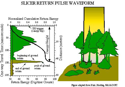
21 Waveform Information
 Airborne Topographic Mapper (ATM) rotating mirror is used for")
22 Airborne LIDAR sensors Laser Vegetation Imaging Sensor (LVIS) Scanning LIDAR imager of Canopies by Echo Recovery (SLICER) Airborne Topographic Mapper (ATM) rotating mirror is used for coverage
23 ICESat NASA s Ice, Cloud, Elevation Satellite (ICESat) Launched 13 Jan 2003 Primary mission is to map ice sheet elevation and changes over the next 3-5 years Instrument is called GLAS
24 Geosciences Laser Altimeter System (GLAS) Frequency-doubled laser system: 1064 nm (NIR) laser wavelength is used for altimetry 532 nm (green) laser wavelength is used for atmospheric characterization (aerosols) 40 pulses per second are transmitted 70m diameter ground footprint, 175m spacing Returned photons are collected through a 1- meter diameter telescope Return time, return power, and waveform provide important information about the surface


25 ICESat Orbit near polar orbit, 94 o inclination 600 km altitude On-board star cameras and gyros provide spacecraft and laser pointing direction. GPS provide spacecraft location
 1-meter accuracy")
26 Tentative: Vegetation Canopy Lidar (VCL) 1-meter accuracy
MODULE 9 LECTURE NOTES 1 PASSIVE MICROWAVE REMOTE SENSING
 MODULE 9 LECTURE NOTES 1 PASSIVE MICROWAVE REMOTE SENSING 1. Introduction The microwave portion of the electromagnetic spectrum involves wavelengths within a range of 1 mm to 1 m. Microwaves possess all
Active and Passive Microwave Remote Sensing
 Active and Passive Microwave Remote Sensing Passive remote sensing system record EMR that was reflected (e.g., blue, green, red, and near IR) or emitted (e.g., thermal IR) from the surface of the Earth.
3/31/03. ESM 266: Introduction 1. Observations from space. Remote Sensing: The Major Source for Large-Scale Environmental Information
 Remote Sensing: The Major Source for Large-Scale Environmental Information Jeff Dozier Observations from space Sun-synchronous polar orbits Global coverage, fixed crossing, repeat sampling Typical altitude
NON-PHOTOGRAPHIC SYSTEMS: Multispectral Scanners Medium and coarse resolution sensor comparisons: Landsat, SPOT, AVHRR and MODIS
 NON-PHOTOGRAPHIC SYSTEMS: Multispectral Scanners Medium and coarse resolution sensor comparisons: Landsat, SPOT, AVHRR and MODIS CLASSIFICATION OF NONPHOTOGRAPHIC REMOTE SENSORS PASSIVE ACTIVE DIGITAL
AGRON / E E / MTEOR 518: Microwave Remote Sensing
 AGRON / E E / MTEOR 518: Microwave Remote Sensing Dr. Brian K. Hornbuckle, Associate Professor Departments of Agronomy, ECpE, and GeAT bkh@iastate.edu What is remote sensing? Remote sensing: the acquisition
The Global Imager (GLI)
") The Global Imager (GLI) Launch : Dec.14, 2002 Initial check out : to Apr.14, 2003 (~L+4) First image: Jan.25, 2003 Second image: Feb.6 and 7, 2003 Calibration and validation : to Dec.14, 2003(~L+4) for
The Global Imager (GLI) Launch : Dec.14, 2002 Initial check out : to Apr.14, 2003 (~L+4) First image: Jan.25, 2003 Second image: Feb.6 and 7, 2003 Calibration and validation : to Dec.14, 2003(~L+4) for
Microwave Remote Sensing
 Provide copy on a CD of the UCAR multi-media tutorial to all in class. Assign Ch-7 and Ch-9 (for two weeks) as reading material for this class. HW#4 (Due in two weeks) Problems 1,2,3 and 4 (Chapter 7)
Active and Passive Microwave Remote Sensing
 Active and Passive Microwave Remote Sensing Passive remote sensing system record EMR that was reflected (e.g., blue, green, red, and near IR) or emitted (e.g., thermal IR) from the surface of the Earth.
An Introduction to Remote Sensing & GIS. Introduction
 An Introduction to Remote Sensing & GIS Introduction Remote sensing is the measurement of object properties on Earth s surface using data acquired from aircraft and satellites. It attempts to measure something
remote sensing? What are the remote sensing principles behind these Definition
 Introduction to remote sensing: Content (1/2) Definition: photogrammetry and remote sensing (PRS) Radiation sources: solar radiation (passive optical RS) earth emission (passive microwave or thermal infrared
Sub-system and System Level Testing and Calibration of Space Altimeters and LIDARS.
 Sub-system and System Level Testing and Calibration of Space Altimeters and LIDARS. Haris Riris, Pete Liiva, Xiaoli Sun, James Abshire Laser Remote Sensing Branch Goddard Space Flight Center, Greenbelt,
Sea surface temperature observation through clouds by the Advanced Microwave Scanning Radiometer 2
 Sea surface temperature observation through clouds by the Advanced Microwave Scanning Radiometer 2 Akira Shibata Remote Sensing Technology Center of Japan (RESTEC) Tsukuba-Mitsui blds. 18F, 1-6-1 Takezono,
Remote Sensing 1 Principles of visible and radar remote sensing & sensors
 Remote Sensing 1 Principles of visible and radar remote sensing & sensors Nick Barrand School of Geography, Earth & Environmental Sciences University of Birmingham, UK Field glaciologist collecting data
Lecture Notes Prepared by Prof. J. Francis Spring Remote Sensing Instruments
 Lecture Notes Prepared by Prof. J. Francis Spring 2005 Remote Sensing Instruments Material from Remote Sensing Instrumentation in Weather Satellites: Systems, Data, and Environmental Applications by Rao,
Microwave Remote Sensing (1)
") Microwave Remote Sensing (1) Microwave sensing encompasses both active and passive forms of remote sensing. The microwave portion of the spectrum covers the range from approximately 1cm to 1m in wavelength.
Microwave Remote Sensing (1) Microwave sensing encompasses both active and passive forms of remote sensing. The microwave portion of the spectrum covers the range from approximately 1cm to 1m in wavelength.
Lecture 02. Introduction of Remote Sensing
 Lecture 02. Introduction of Remote Sensing Concept of Remote Sensing Picture of Remote Sensing Content of Remote Sensing Classification of Remote Sensing Passive Remote Sensing Active Remote Sensing Comparison
QuikScat 6/19/ km AM, 6PM. 705 km :00 PM SeaWiFS. 705 km :01 AM. SeaWinds. Aqua (PM) 5/4/02
 5/4/02") 1997-2004 Revised: 7 January 2009 1997 1998 1999 2000 OrbView-2 1 8/1/97 12:00 PM SeaWiFS TRMM 11/27/97 402 km 35 CERES LIS VIRS TMI PR Landsat 7 4/15/99 10:05 AM ETM+ QuikScat 6/19/99 803 km 98.6 6 AM,
1997-2004 Revised: 7 January 2009 1997 1998 1999 2000 OrbView-2 1 8/1/97 12:00 PM SeaWiFS TRMM 11/27/97 402 km 35 CERES LIS VIRS TMI PR Landsat 7 4/15/99 10:05 AM ETM+ QuikScat 6/19/99 803 km 98.6 6 AM,
746A27 Remote Sensing and GIS
 746A27 Remote Sensing and GIS Lecture 1 Concepts of remote sensing and Basic principle of Photogrammetry Chandan Roy Guest Lecturer Department of Computer and Information Science Linköping University What
ECE Satellite Radar TRMM Precipitation Radar Cloud mm Radar - Cloudsat. Tropical Rainfall Measuring Mission
 Tropical Rainfall Measuring Mission ECE 583 18 Satellite Radar TRMM Precipitation Radar Cloud mm Radar - Cloudsat -TRMM includes 1st spaceborne weather radar - performs cross-track scan to get 3-D view
Environmental Data Records from Special Sensor Microwave Imager and Sounder (SSMIS)
") Environmental Data Records from Special Sensor Microwave Imager and Sounder (SSMIS Fuzhong Weng Center for Satellite Applications and Research National Environmental, Satellites, Data and Information Service
Environmental Data Records from Special Sensor Microwave Imager and Sounder (SSMIS Fuzhong Weng Center for Satellite Applications and Research National Environmental, Satellites, Data and Information Service
Typical technical and operational characteristics of Earth exploration-satellite service (passive) systems using allocations between 1.
 systems using allocations between 1.") Recommendation ITU-R RS.1861 (01/2010) Typical technical and operational characteristics of Earth exploration-satellite service (passive) systems using allocations between 1.4 and 275 GHz RS Series Remote
Recommendation ITU-R RS.1861 (01/2010) Typical technical and operational characteristics of Earth exploration-satellite service (passive) systems using allocations between 1.4 and 275 GHz RS Series Remote
Remote Sensing: John Wilkin IMCS Building Room 211C ext 251. Active microwave systems (1) Satellite Altimetry
 Satellite Altimetry") Remote Sensing: John Wilkin wilkin@marine.rutgers.edu IMCS Building Room 211C 732-932-6555 ext 251 Active microwave systems (1) Satellite Altimetry Active microwave instruments Scatterometer (scattering
Remote Sensing: John Wilkin wilkin@marine.rutgers.edu IMCS Building Room 211C 732-932-6555 ext 251 Active microwave systems (1) Satellite Altimetry Active microwave instruments Scatterometer (scattering
Outline. Introduction. Introduction: Film Emulsions. Sensor Systems. Types of Remote Sensing. A/Prof Linlin Ge. Photographic systems (cf(
 GMAT x600 Remote Sensing / Earth Observation Types of Sensor Systems (1) Outline Image Sensor Systems (i) Line Scanning Sensor Systems (passive) (ii) Array Sensor Systems (passive) (iii) Antenna Radar
Introduction Active microwave Radar
 RADAR Imaging Introduction 2 Introduction Active microwave Radar Passive remote sensing systems record electromagnetic energy that was reflected or emitted from the surface of the Earth. There are also
Altimeter Range Corrections
 Altimeter Range Corrections Schematic Summary Corrections Altimeters Range Corrections Altimeter range corrections can be grouped as follows: Atmospheric Refraction Corrections Sea-State Bias Corrections
Topic 7: PASSIVE MICROWAVE SYSTEMS
 CEE 6100 / CSS 6600 Remote Sensing Fundamentals 1 Topic 7: PASSIVE MICROWAVE SYSTEMS GOALS: At the end of this Section you should be able to: 1. Define the effective wavelength range of microwave systems,
10. PASSIVE MICROWAVE SENSING
 10. PASSIVE MICROWAVE SENSING 10.1 Concepts of Microwave Radiometry A microwave radiometer is a passive sensor that simply measures electromagnetic energy radiated towards it from some target or area.
and Spectrum Protection
 Earth Remote Sensing and Spectrum Protection Steven C. Reising Microwave Systems Laboratory Colorado State University Steven.Reising@ColoState.edu Jff Jeffrey R. Piepmeieri NASA s Goddard Space Flight
UNERSITY OF NAIROBI UNIT: PRICIPLES AND APPLICATIONS OF REMOTE SENSING AND APLLIED CLIMATOLOGY
 UNERSITY OF NAIROBI DEPARTMENT OF METEOROLOGY UNIT: PRICIPLES AND APPLICATIONS OF REMOTE SENSING AND APLLIED CLIMATOLOGY COURSE CODE: SMR 308 GROUP TWO: SENSORS MEMBERS OF GROUP TWO 1. MUTISYA J.M I10/2784/2006
Active microwave systems (1) Satellite Altimetry
 Satellite Altimetry") Remote Sensing: John Wilkin Active microwave systems (1) Satellite Altimetry jwilkin@rutgers.edu IMCS Building Room 214C 732-932-6555 ext 251 Active microwave instruments Scatterometer (scattering from
Remote Sensing: John Wilkin Active microwave systems (1) Satellite Altimetry jwilkin@rutgers.edu IMCS Building Room 214C 732-932-6555 ext 251 Active microwave instruments Scatterometer (scattering from
Remote sensing of the oceans Active sensing
 Remote sensing of the oceans Active sensing Gravity Sea level Ocean tides Low frequency motion Scatterometry SAR http://daac.gsfc.nasa.gov/campaign_docs/ocdst/what_is_ocean_color.html Shape of the earth
RADAR (RAdio Detection And Ranging)
") RADAR (RAdio Detection And Ranging) CLASSIFICATION OF NONPHOTOGRAPHIC REMOTE SENSORS PASSIVE ACTIVE DIGITAL CAMERA THERMAL (e.g. TIMS) VIDEO CAMERA MULTI- SPECTRAL SCANNERS VISIBLE & NIR MICROWAVE Real
RADAR (RAdio Detection And Ranging) CLASSIFICATION OF NONPHOTOGRAPHIC REMOTE SENSORS PASSIVE ACTIVE DIGITAL CAMERA THERMAL (e.g. TIMS) VIDEO CAMERA MULTI- SPECTRAL SCANNERS VISIBLE & NIR MICROWAVE Real
Earth Exploration-Satellite Service (EESS) - Passive Spaceborne Remote Sensing
 - Passive Spaceborne Remote Sensing") Earth Exploration-Satellite Service (EESS) - Passive Spaceborne Remote Sensing John Zuzek Vice-Chairman ITU-R Study Group 7 ITU/WMO Seminar on Spectrum & Meteorology Geneva, Switzerland 16-17 September
Earth Exploration-Satellite Service (EESS) - Passive Spaceborne Remote Sensing John Zuzek Vice-Chairman ITU-R Study Group 7 ITU/WMO Seminar on Spectrum & Meteorology Geneva, Switzerland 16-17 September
ANALYSIS OF REPEATED ICESAT FULL WAVEFORM DATA: METHODOLOGY AND LEAF-ON / LEAF-OFF COMPARISON
 ANALYSIS OF REPEATED ICESAT FULL WAVEFORM DATA: METHODOLOGY AND LEAF-ON / LEAF-OFF COMPARISON Hieu Duong 1 Norbert Pfeifer 2 Roderik Lindenbergh 1 1 1: DEOS, MGP-FRS, 2: University of Innsbruck, Institute
Remote Sensing. Ch. 3 Microwaves (Part 1 of 2)
") Remote Sensing Ch. 3 Microwaves (Part 1 of 2) 3.1 Introduction 3.2 Radar Basics 3.3 Viewing Geometry and Spatial Resolution 3.4 Radar Image Distortions 3.1 Introduction Microwave (1cm to 1m in wavelength)
Remote Sensing Ch. 3 Microwaves (Part 1 of 2) 3.1 Introduction 3.2 Radar Basics 3.3 Viewing Geometry and Spatial Resolution 3.4 Radar Image Distortions 3.1 Introduction Microwave (1cm to 1m in wavelength)
Radiometric performance of Second Generation Global Imager (SGLI) using integrating sphere
 using integrating sphere") Radiometric performance of Second Generation Global Imager (SGLI) using integrating sphere Taichiro Hashiguchi, Yoshihiko Okamura, Kazuhiro Tanaka, Yukinori Nakajima Japan Aerospace Exploration Agency
Radiometric performance of Second Generation Global Imager (SGLI) using integrating sphere Taichiro Hashiguchi, Yoshihiko Okamura, Kazuhiro Tanaka, Yukinori Nakajima Japan Aerospace Exploration Agency
Some Basic Concepts of Remote Sensing. Lecture 2 August 31, 2005
 Some Basic Concepts of Remote Sensing Lecture 2 August 31, 2005 What is remote sensing Remote Sensing: remote sensing is science of acquiring, processing, and interpreting images and related data that
746A27 Remote Sensing and GIS. Multi spectral, thermal and hyper spectral sensing and usage
 746A27 Remote Sensing and GIS Lecture 3 Multi spectral, thermal and hyper spectral sensing and usage Chandan Roy Guest Lecturer Department of Computer and Information Science Linköping University Multi
Dr. Sandra L. Cruz Pol
 OUTLINE INTRODUCTION TO MICROWAVE REMOTE SENSING INEL 8695/6669 Dr. Sandra Cruz Pol Microwave Remote Sensing INEL 6669/8695 Dept. of Electrical & Computer Engineering, UPRM, Mayagüez, PR Importance of
MEthane Remote sensing LIdar mission COPUOS, Vienna June 2013
 CNES CNES/Photon/ill.Michel Regy, 2013 MEthane Remote sensing LIdar mission COPUOS, Vienna 12.-21. June 2013 1 MERLIN COPUOS, Vienna 12.-21. June 2013 CNES Climate Change Temperature Increase over the
Microwave sensors (present and future)
") Proc. Indian Acad. Sci. (Engg. sea.), Vol. 6, Pt. 2, June 1983, pp. 109-119. 9 Printed in India. Microwave sensors (present and future) 1. Introduction O P N CALLA Communications Area, Space Applications
Proc. Indian Acad. Sci. (Engg. sea.), Vol. 6, Pt. 2, June 1983, pp. 109-119. 9 Printed in India. Microwave sensors (present and future) 1. Introduction O P N CALLA Communications Area, Space Applications
Solid Earth Timeline with a smattering of cryosphere technology
 Solid Earth Timeline with a smattering of cryosphere technology Muhammed Kabiru Hassan * Rebecca Boon Image from http://www.clipartheaven.com/show/clipart/technology_&_communication/satellites/satellite_23-gif.html
SATELLITE OCEANOGRAPHY
 SATELLITE OCEANOGRAPHY An Introduction for Oceanographers and Remote-sensing Scientists I. S. Robinson Lecturer in Physical Oceanography Department of Oceanography University of Southampton JOHN WILEY
Copernicus Introduction Lisbon, Portugal 13 th & 14 th February 2014
 Copernicus Introduction Lisbon, Portugal 13 th & 14 th February 2014 Contents Introduction GMES Copernicus Six thematic areas Infrastructure Space data An introduction to Remote Sensing In-situ data Applications
Lecture 6: Multispectral Earth Resource Satellites. The University at Albany Fall 2018 Geography and Planning
 Lecture 6: Multispectral Earth Resource Satellites The University at Albany Fall 2018 Geography and Planning Outline SPOT program and other moderate resolution systems High resolution satellite systems
Frequency bands and bandwidths used for satellite passive remote sensing
 Recommendation ITU-R RS.515-5 (08/2012) Frequency bands and bandwidths used for satellite passive remote sensing RS Series Remote sensing systems ii Rec. ITU-R RS.515-5 Foreword The role of the Radiocommunication
New Small Satellite Capabilities for Microwave Atmospheric Remote Sensing: The Earth Observing Nanosatellite- Microwave (EON-MW)
") New Small Satellite Capabilities for Microwave Atmospheric Remote Sensing: The Earth Observing Nanosatellite- Microwave (EON-MW) W. Blackwell, D. Cousins, and L. Fuhrman MIT Lincoln Laboratory August 6,
New Small Satellite Capabilities for Microwave Atmospheric Remote Sensing: The Earth Observing Nanosatellite- Microwave (EON-MW) W. Blackwell, D. Cousins, and L. Fuhrman MIT Lincoln Laboratory August 6,
Kazuhiro TANAKA GCOM project team/jaxa April, 2016
 Kazuhiro TANAKA GCOM project team/jaxa April, 216 @ SPIE Asia-Pacific 216 at New Dehli, India 1 http://suzaku.eorc.jaxa.jp/gcom_c/index_j.html GCOM mission and satellites SGLI specification and IRS overview
ADDITIONAL SATELLITE AND SENSORS
 ADDITIONAL SATELLITE AND SENSORS A list of additional satellites and sensors, along with links to appropriate websites, is presented below. ACRIMSAT (Active Cavity Radiometer Irradiance Monitor Satellite)
Lecture 13: Remotely Sensed Geospatial Data
 Lecture 13: Remotely Sensed Geospatial Data A. The Electromagnetic Spectrum: The electromagnetic spectrum (Figure 1) indicates the different forms of radiation (or simply stated light) emitted by nature.
SEA SURFACE TEMPERATURE RETRIEVAL USING TRMM MICROWAVE IMAGER DATA IN SOUTH CHINA SEA
 SEA SURFACE TEMPERATURE RETRIEVAL USING TRMM MICROWAVE IMAGER DATA IN SOUTH CHINA SEA Mohd Ibrahim Seeni Mohd and Mohd Nadzri Md. Reba Faculty of Geoinformation Science and Engineering Universiti Teknologi
Current and Future Meteorological Satellite Program of China
 Current and Future Meteorological Satellite Program of China ZHANG Wenjian, DONG Chaohua XU Jianmin, YANG Jun China Meteorological Administration May 30, 2005 Beijing, CHINA Outline of the Presentation
LE/ESSE Payload Design
 LE/ESSE4360 - Payload Design 3.2 Spacecraft Sensors Introduction to Sensors Earth, Moon, Mars, and Beyond Dr. Jinjun Shan, Professor of Space Engineering Department of Earth and Space Science and Engineering
EE 529 Remote Sensing Techniques. Introduction
 EE 529 Remote Sensing Techniques Introduction Course Contents Radar Imaging Sensors Imaging Sensors Imaging Algorithms Imaging Algorithms Course Contents (Cont( Cont d) Simulated Raw Data y r Processing
10 Satellite-Based Remote Sensing
 10 Satellite-Based Remote Sensing 10.1 Introduction Those beginning to read the book at this chapter could find it troublesome with so many references to previous chapters, but it is the only way we found
9/12/2011. Training Course Remote Sensing Basic Theory & Image Processing Methods September 2011
 Training Course Remote Sensing Basic Theory & Image Processing Methods 19 23 September 2011 Remote Sensing Platforms Michiel Damen (September 2011) damen@itc.nl 1 Overview Platforms & missions aerial surveys
Introduction to Remote Sensing Fundamentals of Satellite Remote Sensing. Mads Olander Rasmussen
 Introduction to Remote Sensing Fundamentals of Satellite Remote Sensing Mads Olander Rasmussen (mora@dhi-gras.com) 01. Introduction to Remote Sensing DHI What is remote sensing? the art, science, and technology
Outlines. Attenuation due to Atmospheric Gases Rain attenuation Depolarization Scintillations Effect. Introduction
 PROPAGATION EFFECTS Outlines 2 Introduction Attenuation due to Atmospheric Gases Rain attenuation Depolarization Scintillations Effect 27-Nov-16 Networks and Communication Department Loss statistics encountered
The studies began when the Tiros satellites (1960) provided man s first synoptic view of the Earth s weather systems.
 provided man s first synoptic view of the Earth s weather systems.") Remote sensing of the Earth from orbital altitudes was recognized in the mid-1960 s as a potential technique for obtaining information important for the effective use and conservation of natural resources.
Remote sensing of the Earth from orbital altitudes was recognized in the mid-1960 s as a potential technique for obtaining information important for the effective use and conservation of natural resources.
Introduction to Radar
 National Aeronautics and Space Administration ARSET Applied Remote Sensing Training http://arset.gsfc.nasa.gov @NASAARSET Introduction to Radar Jul. 16, 2016 www.nasa.gov Objective The objective of this
Active And Passive Microwave Remote Sensing
 We have made it easy for you to find a PDF Ebooks without any digging. And by having access to our ebooks online or by storing it on your computer, you have convenient answers with active and passive microwave
Microwave Sensors Subgroup (MSSG) Report
 Report") Microwave Sensors Subgroup (MSSG) Report Feb 17-20, 2014, ESA ESRIN, Frascati, Italy DONG, Xiaolong, MSSG Chair National Space Science Center Chinese Academy of Sciences (MiRS,NSSC,CAS) Email: dongxiaolong@mirslab.cn
Microwave Sensors Subgroup (MSSG) Report Feb 17-20, 2014, ESA ESRIN, Frascati, Italy DONG, Xiaolong, MSSG Chair National Space Science Center Chinese Academy of Sciences (MiRS,NSSC,CAS) Email: dongxiaolong@mirslab.cn
REMOTE SENSING INTERPRETATION
 REMOTE SENSING INTERPRETATION Jan Clevers Centre for Geo-Information - WU Remote Sensing --> RS Sensor at a distance EARTH OBSERVATION EM energy Earth RS is a tool; one of the sources of information! 1
Wireless Power Transmission of Solar Energy from Space to Earth Using Microwaves
 Wireless Power Transmission of Solar Energy from Space to Earth Using Microwaves Raghu Amgothu Contract Lecturer in ECE Dept., Government polytechnic Warangal Abstract- In the previous stages, we are studying
Int n r t o r d o u d c u ti t on o n to t o Remote Sensing
 Introduction to Remote Sensing Definition of Remote Sensing Remote sensing refers to the activities of recording/observing/perceiving(sensing)objects or events at far away (remote) places. In remote sensing,
Design and Development of a Ground-based Microwave Radiometer System
 PIERS ONLINE, VOL. 6, NO. 1, 2010 66 Design and Development of a Ground-based Microwave Radiometer System Yu Zhang 1, 2, Jieying He 1, 2, and Shengwei Zhang 1 1 Center for Space Science and Applied Research,
Sources of Geographic Information
 Sources of Geographic Information Data properties: Spatial data, i.e. data that are associated with geographic locations Data format: digital (analog data for traditional paper maps) Data Inputs: sampled
ECE Lecture 32
 ECE 5010 - Lecture 32 1 Microwave Radiometry 2 Properties of a Radiometer 3 Radiometric Calibration and Uncertainty 4 Types of Radiometer Measurements Levis, Johnson, Teixeira (ESL/OSU) Radiowave Propagation
MODULE 9 LECTURE NOTES 2 ACTIVE MICROWAVE REMOTE SENSING
 MODULE 9 LECTURE NOTES 2 ACTIVE MICROWAVE REMOTE SENSING 1. Introduction Satellite sensors are capable of actively emitting microwaves towards the earth s surface. An active microwave system transmits
John P. Stevens HS: Remote Sensing Test
 Name(s): Date: Team name: John P. Stevens HS: Remote Sensing Test 1 Scoring: Part I - /18 Part II - /40 Part III - /16 Part IV - /14 Part V - /93 Total: /181 2 I. History (3 pts. each) 1. What is the name
GEOS 107: The Planet Earth Session 7. Geographic Information Science: Remote Sensing, GIS and GPS/1. Dr. Mark J Chopping
 GEOS 107: The Planet Earth Session 7 Geographic Information Science: Remote Sensing, GIS and GPS/1 Dr. Mark J Chopping Geographic Information Science We have 3 sessions on Geographic Information Science:
Remote sensing radio applications/ systems for environmental monitoring
 Remote sensing radio applications/ systems for environmental monitoring Alexandre VASSILIEV ITU Radiocommunication Bureau phone: +41 22 7305924 e-mail: alexandre.vassiliev@itu.int 1 Source: European Space
IKONOS High Resolution Multispectral Scanner Sensor Characteristics
 High Spatial Resolution and Hyperspectral Scanners IKONOS High Resolution Multispectral Scanner Sensor Characteristics Launch Date View Angle Orbit 24 September 1999 Vandenberg Air Force Base, California,
Microwave Sensors Subgroup (MSSG) Report
 Report") Microwave Sensors Subgroup (MSSG) Report CEOS WGCV-35 May 13-17, 2013, Shanghai, China DONG, Xiaolong, MSSG Chair CAS Key Laboratory of Microwave Remote Sensing National Space Science Center Chinese Academy
Microwave Sensors Subgroup (MSSG) Report CEOS WGCV-35 May 13-17, 2013, Shanghai, China DONG, Xiaolong, MSSG Chair CAS Key Laboratory of Microwave Remote Sensing National Space Science Center Chinese Academy
Status of MOLI development MOLI (Multi-footprint Observation Lidar and Imager)
") Status of MOLI development MOLI (Multi-footprint Observation Lidar and Imager) Tadashi IMAI, Daisuke SAKAIZAWA, Jumpei MUROOKA and Toshiyoshi KIMURA JAXA 1 Outline of This Presentation 1. Overview of MOLI
Status of MOLI development MOLI (Multi-footprint Observation Lidar and Imager) Tadashi IMAI, Daisuke SAKAIZAWA, Jumpei MUROOKA and Toshiyoshi KIMURA JAXA 1 Outline of This Presentation 1. Overview of MOLI
Remote Sensing: John Wilkin IMCS Building Room 211C ext 251. Active microwave systems (1) Satellite Altimetry
 Satellite Altimetry") Remote Sensing: John Wilkin wilkin@marine.rutgers.edu IMCS Building Room 211C 732-932-6555 ext 251 Active microwave systems (1) Satellite Altimetry Active microwave instruments Scatterometer (scattering
Remote Sensing: John Wilkin wilkin@marine.rutgers.edu IMCS Building Room 211C 732-932-6555 ext 251 Active microwave systems (1) Satellite Altimetry Active microwave instruments Scatterometer (scattering
Copyrighted Material. Contents
 Preface xiii 1 Introduction 1 1.1 Concepts 1 1.2 Spacecraft Sensors Cost 5 1.2.1 Introduction to Cost Estimating 5 1.2.2 Cost Data 7 1.2.3 Cost Estimating Methodologies 8 1.2.4 The Cost Estimating Relationship
Geo/SAT 2 INTRODUCTION TO REMOTE SENSING
 Geo/SAT 2 INTRODUCTION TO REMOTE SENSING Paul R. Baumann, Professor Emeritus State University of New York College at Oneonta Oneonta, New York 13820 USA COPYRIGHT 2008 Paul R. Baumann Introduction Remote
ATS 351 Lecture 9 Radar
 ATS 351 Lecture 9 Radar Radio Waves Electromagnetic Waves Consist of an electric field and a magnetic field Polarization: describes the orientation of the electric field. 1 Remote Sensing Passive vs Active
PASSIVE MICROWAVE PROTECTION: IMPACT OF RFI INTERFERENCE ON SATELLITE PASSIVE OBSERVATIONS
 PASSIVE MICROWAVE PROTECTION: IMPACT OF RFI INTERFERENCE ON SATELLITE PASSIVE OBSERVATIONS Jean PLA CNES, Toulouse, France Frequency manager 1 Description of the agenda items 1.2 and 1.20 for the next
Spectral Signatures. Vegetation. 40 Soil. Water WAVELENGTH (microns)
") Spectral Signatures % REFLECTANCE VISIBLE NEAR INFRARED Vegetation Soil Water.5. WAVELENGTH (microns). Spectral Reflectance of Urban Materials 5 Parking Lot 5 (5=5%) Reflectance 5 5 5 5 5 Wavelength (nm)
Spectral Signatures % REFLECTANCE VISIBLE NEAR INFRARED Vegetation Soil Water.5. WAVELENGTH (microns). Spectral Reflectance of Urban Materials 5 Parking Lot 5 (5=5%) Reflectance 5 5 5 5 5 Wavelength (nm)
An Introduction to Geomatics. Prepared by: Dr. Maher A. El-Hallaq خاص بطلبة مساق مقدمة في علم. Associate Professor of Surveying IUG
 An Introduction to Geomatics خاص بطلبة مساق مقدمة في علم الجيوماتكس Prepared by: Dr. Maher A. El-Hallaq Associate Professor of Surveying IUG 1 Airborne Imagery Dr. Maher A. El-Hallaq Associate Professor
RADAR REMOTE SENSING
 RADAR REMOTE SENSING Jan G.P.W. Clevers & Steven M. de Jong Chapter 8 of L&K 1 Wave theory for the EMS: Section 1.2 of L&K E = electrical field M = magnetic field c = speed of light : propagation direction
Lecture 03. Lidar Remote Sensing Overview (1)
") Lecture 03. Lidar Remote Sensing Overview (1) Introduction History from searchlight to modern lidar Various modern lidars Altitude/Range determination Basic lidar architecture Summary Introduction: Lidar
Lecture 03. Lidar Remote Sensing Overview (1) Introduction History from searchlight to modern lidar Various modern lidars Altitude/Range determination Basic lidar architecture Summary Introduction: Lidar
9/12/2011. Training Course Remote Sensing Basic Theory & Image Processing Methods September 2011
 Training Course Remote Sensing Basic Theory & Image Processing Methods 19 23 September 2011 Popular Remote Sensing Sensors & their Selection Michiel Damen (September 2011) damen@itc.nl 1 Overview Low resolution
Remote Sensing for Resource Management
 Remote Sensing for Resource Management Ebenezer Nyadjro US Naval Research Lab/UNO RMU Summer Program (July 31-AUG 4, 2017) Motivation Polluted Pra River Motivation. 3 Motivation Polluted Pra River Motivation.
Fundamentals of Remote Sensing
 Climate Variability, Hydrology, and Flooding Fundamentals of Remote Sensing May 19-22, 2015 GEO-Latin American & Caribbean Water Cycle Capacity Building Workshop Cartagena, Colombia 1 Objective To provide
9 Moisture Monitoring
 9 Moisture Monitoring Microwave techniques have been considered for moisture sensing in many food processing and agriculture-related industries (Trabelsi, et al. 1998b). Chapter 7 highlighted the strong
Satellite Imagery and Remote Sensing. DeeDee Whitaker SW Guilford High EES & Chemistry
 Satellite Imagery and Remote Sensing DeeDee Whitaker SW Guilford High EES & Chemistry whitakd@gcsnc.com Outline What is remote sensing? How does remote sensing work? What role does the electromagnetic
Introduction to Microwave Remote Sensing
 Introduction to Microwave Remote Sensing lain H. Woodhouse The University of Edinburgh Scotland Taylor & Francis Taylor & Francis Group Boca Raton London New York A CRC title, part of the Taylor & Francis
Are Radiometers and Scatterometers Seeing the Same Wind Speed?
 Are Radiometers and Scatterometers Seeing the Same Wind Speed? Frank J. Wentz and Thomas Meissner Remote Sensing Systems NASA Ocean Vector Wind Science Team Meeting May 18-, 9 Boulder, CO Radiometer and
Assessment of instrument STability and Retrieval Algorithms for SMOS data (ASTRA)
") Assessment of instrument STability and Retrieval Algorithms for SMOS data (ASTRA) S.Paloscia IFAC-CNR MRSG - Microwave Remote Sensing Group Florence (Italy) Microwave Remote Sensing Group I - DOMEX-2 :
Assessment of instrument STability and Retrieval Algorithms for SMOS data (ASTRA) S.Paloscia IFAC-CNR MRSG - Microwave Remote Sensing Group Florence (Italy) Microwave Remote Sensing Group I - DOMEX-2 :
CHAPTER --'3 DATA DESCRIPTION
 CHAPTER --'3 DATA DESCRIPTION 37 3.1 INTRODUCTION In chapter 2 different techniques used for the study of polar cryosphere like passive and active remote sensing, altimetry and scatterometry are described.
Active microwave systems (2) Satellite Altimetry * range data processing * applications
 Satellite Altimetry * range data processing * applications") Remote Sensing: John Wilkin wilkin@marine.rutgers.edu IMCS Building Room 211C 732-932-6555 ext 251 Active microwave systems (2) Satellite Altimetry * range data processing * applications Satellite Altimeters
Remote Sensing: John Wilkin wilkin@marine.rutgers.edu IMCS Building Room 211C 732-932-6555 ext 251 Active microwave systems (2) Satellite Altimetry * range data processing * applications Satellite Altimeters
Satellite Remote Sensing: Earth System Observations
 Satellite Remote Sensing: Earth System Observations Land surface Water Atmosphere Climate Ecosystems 1 EOS (Earth Observing System) Develop an understanding of the total Earth system, and the effects of
ACTIVE SENSORS RADAR
 ACTIVE SENSORS RADAR RADAR LiDAR: Light Detection And Ranging RADAR: RAdio Detection And Ranging SONAR: SOund Navigation And Ranging Used to image the ocean floor (produce bathymetic maps) and detect objects
Govt. Engineering College Jhalawar Model Question Paper Subject- Remote Sensing & GIS
 Govt. Engineering College Jhalawar Model Question Paper Subject- Remote Sensing & GIS Time: Max. Marks: Q1. What is remote Sensing? Explain the basic components of a Remote Sensing system. Q2. What is
Module 3 Introduction to GIS. Lecture 8 GIS data acquisition
 Module 3 Introduction to GIS Lecture 8 GIS data acquisition GIS workflow Data acquisition (geospatial data input) GPS Remote sensing (satellites, UAV s) LiDAR Digitized maps Attribute Data Management Data
Aquarius/SAC-D Mission Mission Simulators - Gary Lagerloef 6 th Science Meeting; Seattle, WA, USA July 2010
 Aquarius/SAC-D Mission Mission Simulators - Gary Lagerloef 6 th Science Meeting; Seattle, WA, USA Mission Design and Sampling Strategy Sun-synchronous exact repeat orbit 6pm ascending node Altitude 657
MERLIN Mission Status
 MERLIN Mission Status CNES/illustration David DUCROS, 2016 G. Ehret 1, P. Bousquet 2, B. Millet 3, M. Alpers 1, C. Deniel 3, A. Friker 1, C. Pierangelo 3 1 Deutsches Zentrum für Luft- und Raumfahrt (DLR)