Fundamentals of Remote Sensing: SAR Interferometry
|
|
|
- Alannah Jennings
- 6 years ago
- Views:
Transcription


1 INSIS Fundamentals of Remote Sensing: SAR Interferometry Notions fondamentales de télédétection : l interférométrie RSO Gabriel VASILE Chargé de Recherche CNRS gabriel.vasile@gipsa-lab.grenoble-inp.fr Nikola BESIC Doctorant nikola.besic@gipsa-lab.grenoble-inp.fr 1 Télédétection radar 3A SICOM SIM SN


2 azimut SAR focusing: ERS-1, Chamonix valley, pixels range Range focusing Azimuth focusing SAR image formation: Echolocation: short pulse Linear frequency (chirp) modulation Demodulation: match filtering Synthetic Aperture Radar SAR amplitude image SYTER, Telecom ParisTech 2 Télédétection radar 3A SICOM SIM SN


3 azimut SAR focusing: ERS-1, Chamonix valley, pixels range Range focusing Azimuth focusing SAR image formation: Echolocation: short pulse Linear frequency (chirp) modulation Demodulation: match filtering Synthetic Aperture Radar SAR phase image SYTER, Telecom ParisTech POL/In/POL-InSAR 3 Télédétection radar 3A SICOM SIM SN


4 Sinclair formula & differential measurements Emission: H and V Reception: H and V E S e jkr r I S E S S S HH VH S S HV VV Penetration depth + I E S E Propagation Backscattering mechanisms 2 phenomena -> differential measurements 4 Télédétection radar 3A SICOM SIM SN

5 Differential measurements InSAR E S e jkr r I S E -> wave/media interactions -> path difference Two SLC images: k M (master), k S (slave) Same target area Slightly different viewing angles Hermitian product -> complex cross-correlation M&S intensities Internal coherence 5 Télédétection radar 3A SICOM SIM SN

6 Differential measurements InSAR E S e jkr r I S E -> wave/media interactions -> path difference Two SLC images: k M (master), k S (slave) Same target area Slightly different viewing angles Hermitian product -> complex cross-correlation Normalized complex cross-correlation INTERFEROMETRIC PHASE: = arg{c} INTERFEROMETRIC COHERENCE: c = ABS{C} 6 Télédétection radar 3A SICOM SIM SN
: k=[s HH +S VV S HH -S VV 2S HV ] T Hermitian product -> complex correlation Polarimetric coherency matrix 7 Télédétection radar 3A")
7 Differential measurements POLSAR E S e jkr r I S E -> wave/media interactions -> path difference Fully polarimetric SAR data Cross-polar symmetrisation (monostatic case) Vectorisation on the Pauli basis (target vector): k=[s HH +S VV S HH -S VV 2S HV ] T Hermitian product -> complex correlation Polarimetric coherency matrix 7 Télédétection radar 3A SICOM SIM SN

8 Differential measurements POL-InSAR E S e jkr r I S E Two acquisitions -> wave/media interactions -> path difference Three polarization configurations k {HH,VV,HV} Hermitian product -> complex correlation Polarimetric M&S coherency matrices: Polarimetric interferometric coherency matrix: 8 Télédétection radar 3A SICOM SIM SN

9 Radar Interferometry Outlines Overview of interferometry Satellite Interferometry Satellite InSAR geometry InSAR processing measuring topography Satellite Differential InSAR D-InSAR processing measuring motion on the Earth s surface SAR examples 9 Télédétection radar 3A SICOM SIM SN
10 Satellite Interferometry For satellite interferometry of the repeat-pass type, one image is taken one day, and a second image is taken of the same scene one or more days later. More images can be taken at later intervals and used in the processing, as long as the scene retains reasonable coherence over the longer time interval Because there is always a time delay, and usually parallax as well, assumptions must be made or processing must be done to remove the unwanted component of motion or topography In Feb. 2000, the Shuttle Radar Topography Mission obtained topographic (elevation) data of much of the Earth s surface using single-pass interferometry, i.e., image pairs were acquired at the same time using two radar antennas separated physically to create a 60-m fixed baseline. 10 Télédétection radar 3A SICOM SIM SN
11 Radar Interferometry from Space SRTM TANDEM ERS-1/2 11 Télédétection radar 3A SICOM SIM SN
12 Radar Interferometry from Space SRTM TANDEM ERS-1/2 12 Télédétection radar 3A SICOM SIM SN

13 Radar Interferometry from Space : SRTM mission NASA / DLR 13 Télédétection radar 3A SICOM SIM SN
 NASA / DLR 14 Télédétection radar 3A")
14 Coverage of 11-day SRTM Mission (Feb. 2000) NASA / DLR 14 Télédétection radar 3A SICOM SIM SN

15 SRTM Perspective View with Landsat Overlay Elevation data from C-band across-track interferometric radar, SRTM Acquired Feb. 16, 2000 Height exaggeration 2x Landsat overlay Acquired: Dec. 14, 1984 View toward the North N W Santa Clara River Valley, California NASA / DLR 15 Télédétection radar 3A SICOM SIM SN

16 ERS 1 and ERS 2 TANDEM Mission ( ) ESA Repeat pass interferometric SAR uses two antenna positions to acquire two SAR images. Vertical height is determined by comparing phase measurements. Observable terrain shifts are on the order of the radar wavelength or smaller. 16 Télédétection radar 3A SICOM SIM SN
17 Radar Interferometry from Space 17 Télédétection radar 3A SICOM SIM SN
 indicates the degree of phase correlation. Low coherence indicates greater change (lakes at upper left).")
18 ERS 1 and ERS 2 TANDEM Mission Schefferville, Québec Colour: Interferogram Phase, 16 steps from 0 to 2π radians Intensity: Interferogram Magnitude Saturation: Coherence Interferogram Magnitude is the background black-and-white image - similar to regular SAR image. Coherence (colour brightness) indicates the degree of phase correlation. Low coherence indicates greater change (lakes at upper left). High coherence indicates least change (exposed rocks at lower left). Colour-coded interferogram phase: a phase change of 2π radians corresponds to an altitude change of 232 m 18 Télédétection radar 3A SICOM SIM SN
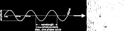
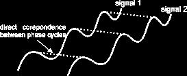
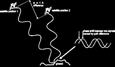
19 Satellite Repeat-pass InSAR Geometry A radar is essentially a distance or range measuring sensor It can measure range in 2 ways: Time delay: R=c/2B = 8 m Phase: R=λ/100 = 1 mm Phase is much more accurate but is a relative measurement only 19 Télédétection radar 3A SICOM SIM SN
20 How a SAR Measures Phase 20 Télédétection radar 3A SICOM SIM SN

21 Phase after Scattering from a Random Surface 21 Télédétection radar 3A SICOM SIM SN

22 Interferometer Phase 22 Télédétection radar 3A SICOM SIM SN

23 How Differential Phase Measures Topography 23 Télédétection radar 3A SICOM SIM SN
 φ(m) < π Unwrapped phase Automatic methods: local approach : cuts")
 (M) if (N) (M) c (M,N) 2 if (N) (M) 2 if (N) (M) 24 Télédétection radar 3A SICOM")
24 Phase Unwrapping Interferometric phase ambiguity φ Wrapped phase = φ (mod 2π) Nyquist criterion φ(n) φ(m) < π Unwrapped phase Automatic methods: local approach : cuts positioning, propagation global approach: least squares (phase or local frequencies) (N) (M) if (N) (M) c (M,N) 2 if (N) (M) 2 if (N) (M) 24 Télédétection radar 3A SICOM SIM SN
25 Interferogram Estimation 2 images single look complex (SLC): u 1 ( m, n) ( m, n) e After co-registration: u 1 ( m, n). u 1 * 2 i ( m, n) 1 1 u 2 ( m, n) ( m, n) e ( m, n) ( m, n). ( m, n). e 2 2 i ( m, n) 2 i( ) 1 2 SLC 1 u1( m, n) SLC 2 u2( m, n) Complex multi-looking: C( i, j) ( m, n) ( m, n) 1 u ( m, n). u 1 u ( m, n) 2 * 2 ( m, n) ( m, n) u 2 (m,n) ( m, n) 2 (i,j) Amp 1 a1( i, j) Coh. C( i, j) Amp 2 a2( i, j) Phase arg( C( i, j)) 25 Télédétection radar 3A SICOM SIM SN
(1 D 2 ) L d(1 d 2 ) L2 2 F ( L, L;1; d 1 2 D 2 ) Distribution function of L, D = 0.5 Bias function of L 26 Télédétection radar 3A SICOM SIM SN")
26 Coherence Estimation Distribution of the sample coherence d as function of theoretical coherence value D and the number of looks L>1: p( d D, L) 2( L 1)(1 D 2 ) L d(1 d 2 ) L2 2 F ( L, L;1; d 1 2 D 2 ) Distribution function of L, D = 0.5 Bias function of L 26 Télédétection radar 3A SICOM SIM SN
 (1 ),, ( 2 1 2 1 2 2 2 1 0 1 2 2 1 2 2 L L D L F D D L F D L D p L Distribution function of D = 0, L = 4 Distribution function of L = 0, D = 0.")
27 27 Télédétection radar 3A SICOM SIM SN Distribution of the sample phase as function of theoretical coherence value D and the number of looks L>1: ) ( ) ( ) ( )) ( cos ; ; ( ) cos( )) ( cos ; 2 1 ; (1, 2 ) (1 ),, ( L L D L F D D L F D L D p L Distribution function of D = 0, L = 4 Distribution function of L = 0, D = 0.7 D Phase Estimation
28 Measuring Coherence Coherence must always be measured to assess the suitability of the data set for InSAR processing Coherence magnitude is closely related to the local standard deviation of differential phase High coherence magnitude tells us: images have good SNR phase centres of scatterers are stable any motion is spatially organized Coherence magnitude: is useable, but noisy is good is excellent Coherence has also been successfully used as a terrain classification parameter: water, vegetation, desert, city 28 Télédétection radar 3A SICOM SIM SN
29 InSAR Processing Process data to SLC images Register the two images to 1/10 pixel Over-sample by a factor of 2 in both dimensions Filter common bands in spectrum Conjugate multiply to form interferogram Smooth the interferogram Measure coherence Unwrap phase Estimate geometry parameters (especially baseline) Remove flat-earth fringes Convert unwrapped phase to height and/or motion 29 Télédétection radar 3A SICOM SIM SN

30 InSAR Processing: Chitina River Valley, S.E. Alaska B = 40 m Flat-earth fringes were removed. Phase is still wrapped. Each revolution of the colour wheel represents an increase of 200 m in altitude. ERS images acquired Feb Télédétection radar 3A SICOM SIM SN

31 Topography Contours from Interferogram: ERS-1, 1991 Franklin Bluffs and Sagavanirktok River on the North Slope of Alaska Perspective view generated from an interferometrically derived DEM 31 Télédétection radar 3A SICOM SIM SN

32 Radar Differential Interferometry from Space 32 Télédétection radar 3A SICOM SIM SN


33 Radar Differential Interferometry from Space The information contained in the D-InSAR phase can be decomposed in: 33 Télédétection radar 3A SICOM SIM SN
34 Radar Differential Interferometry from Space 34 Télédétection radar 3A SICOM SIM SN
35 D-InSAR: orbital compensation 35 Télédétection radar 3A SICOM SIM SN
 36 Télédétection radar 3A SICOM")
36 D-InSAR: topographic compensation (DTM) 36 Télédétection radar 3A SICOM SIM SN

37 D-InSAR: adaptive filtering 37 Télédétection radar 3A SICOM SIM SN

 15 (km²) / 9 (km) Mean slope ~ 9 (17%) ~14 (26%) 38 LISTIC/LAPI")
38 Location Glaciology: temperate glaciers French Alps Chamonix Mont-Blanc test site Mer-de-Glace Argentière Location N/ E N / E Area / Length 3,5 (km²) / 4.7 (km) 15 (km²) / 9 (km) Mean slope ~ 9 (17%) ~14 (26%) 38 LISTIC/LAPI Télédétection radar 3A SICOM SIM SN 38


39 ERS - 1/2: visibility assessment ERS ascending (image panchromatic SPOT-1) ERS descending 39 Télédétection radar 3A SICOM SIM SN


 (c)")

40 ERS-1/2 Interferogram (March 1996) SAR amplitude 5 km 100 km TANDEM ERS (Mer-de-glace) (c) InSAR coherence InSAR phase 40 Télédétection radar 3A SICOM SIM SN


![361 pixels] 41](/docs-images/72/66772946/images/41-11.jpg "Télédétection")
41 D-InSAR Parameter Estimation amplitude coherence phase IDAN ML amplitude IDAN ML coherence IDAN ML phase Mer-de-glace [ pixels] 41 Télédétection radar 3A SICOM SIM SN


42 Measuring Glacier Velocity by D-InSAR filtered phase 2D local frequencies filtered coherence 2D phase unwrapping Geocoding 3D projection velocity field DTM In situ mesures TANDEM ERS, 10/11-March-1996 Chamonix Mont-Blanc Hypotheses on flow direction 42 Télédétection radar 3A SICOM SIM SN


43 D-InSAR Phase Unwrapping IDAN ML phase mod 2π IDAN ML unwrapped phase Mer-de-glace [ pixels]: weighted least-square phase unwrapping 43 Télédétection radar 3A SICOM SIM SN
:")


44 From Slant Range to Ground Range DTM (Lat/Lon, WGS 1984): separating relief / displacement geocoding D-InSAR scalar measurement: slant range displacement 44 Télédétection radar 3A SICOM SIM SN


45 Glacier Velocity Field: Argentière & Mer-de-glace In situ measurements: unknown offset ablation sticks differential GPS D-InSAR/DTM measurements: 3D displacement field glacier flow direction (SPF,MSF) 45 Télédétection radar 3A SICOM SIM SN

46 46 Télédétection radar 3A SICOM SIM SN

47 47 Télédétection radar 3A SICOM SIM SN

48 48 Télédétection radar 3A SICOM SIM SN

49 49 Télédétection radar 3A SICOM SIM SN

50 50 Télédétection radar 3A SICOM SIM SN

51 51 Télédétection radar 3A SICOM SIM SN

52 52 Télédétection radar 3A SICOM SIM SN

53 53 Télédétection radar 3A SICOM SIM SN

54 54 Télédétection radar 3A SICOM SIM SN

55 TerraSAR-X StripMap Acquisition (3m res) of the Pyramids of Giza, Egypt Prel. Image recorded during calibration phase Télédétection radar 3A SICOM SIM SN


56 South Nigeria, 3m res TerraSAR-X Basic Image Products Warri airport City of Warri 56 Télédétection radar 3A SICOM SIM SN 56
 1m res")

57 TerraSAR-X Basic Image Products Cape Town (South Africa) 1m res International airport 57 Télédétection radar 3A SICOM SIM SN 57

58 TerraSAR-X Basic Image Products Mombasa (Kenya) 1m res Télédétection radar 3A SICOM SIM SN


59 Addis Abeba (Ethiopia), 3m res TerraSAR-X Basic Image Products 59 Télédétection radar 3A SICOM SIM SN 59
60 Bibliography Presentation available at: H. Maître, Traitement des images de RSO, Hermes Sciences Publications, 2001 L. Lliboutry, Sciences Géométriques et Télédétection, Masson, 1992 C. Elachi, Introduction to the Physics and Techniques of Remote Sensing, Wiley Series in Remote Sensing, 1987 Tutoriel du Centre Canadien de Télédétection (CCT): Trouvé E., Imagerie Radar à Synthèse d Ouverture, cours ETASM, Université de Savoie, 2004 Faller N., TerraSAR-X: Surveying, Mapping & Infrastructure Development, Map Africa 2007 Hajnsek I. at al., TerraSAR-X Mission: Application and Data Access, Int. Summer School on Very High Resolution Remote Sensing, Télédétection radar 3A SICOM SIM SN
Fundamentals of Remote Sensing: the Imaging RADAR System
 INSIS Fundamentals of Remote Sensing: the Imaging RADAR System Notions fondamentales de télédétection : le RADAR imageur Gabriel VASILE Chargé de Recherche CNRS gabriel.vasile@gipsa-lab.grenoble-inp.fr
Synthetic Aperture Radar Interferometry (InSAR) Technique (Lecture I- Tuesday 11 May 2010)
 Technique (Lecture I- Tuesday 11 May 2010)") Synthetic Aperture Radar Interferometry () Technique (Lecture I- Tuesday 11 May 2010) ISNET/CRTEAN Training Course on Synthetic Aperture Radar (SAR) Imagery: Processing, Interpretation and Applications
Synthetic Aperture Radar Interferometry () Technique (Lecture I- Tuesday 11 May 2010) ISNET/CRTEAN Training Course on Synthetic Aperture Radar (SAR) Imagery: Processing, Interpretation and Applications
SARscape Modules for ENVI
 Visual Information Solutions SARscape Modules for ENVI Read, process, analyze, and output products from SAR data. ENVI. Easy to Use Tools. Proven Functionality. Fast Results. DEM, based on TerraSAR-X-1
RADAR REMOTE SENSING
 RADAR REMOTE SENSING Jan G.P.W. Clevers & Steven M. de Jong Chapter 8 of L&K 1 Wave theory for the EMS: Section 1.2 of L&K E = electrical field M = magnetic field c = speed of light : propagation direction
ANALYSIS OF SRTM HEIGHT MODELS
 ANALYSIS OF SRTM HEIGHT MODELS Sefercik, U. *, Jacobsen, K.** * Karaelmas University, Zonguldak, Turkey, ugsefercik@hotmail.com **Institute of Photogrammetry and GeoInformation, University of Hannover,
Detection of a Point Target Movement with SAR Interferometry
 Journal of the Korean Society of Remote Sensing, Vol.16, No.4, 2000, pp.355~365 Detection of a Point Target Movement with SAR Interferometry Jung-Hee Jun* and Min-Ho Ka** Agency for Defence Development*,
COMPARATIVE ANALYSIS OF INSAR DIGITAL SURFACE MODELS FOR TEST AREA BUCHAREST
 COMPARATIVE ANALYSIS OF INSAR DIGITAL SURFACE MODELS FOR TEST AREA BUCHAREST Iulia Dana (1), Valentin Poncos (2), Delia Teleaga (2) (1) Romanian Space Agency, 21-25 Mendeleev Street, 010362, Bucharest,
THE NASA/JPL AIRBORNE SYNTHETIC APERTURE RADAR SYSTEM. Yunling Lou, Yunjin Kim, and Jakob van Zyl
 THE NASA/JPL AIRBORNE SYNTHETIC APERTURE RADAR SYSTEM Yunling Lou, Yunjin Kim, and Jakob van Zyl Jet Propulsion Laboratory California Institute of Technology 4800 Oak Grove Drive, MS 300-243 Pasadena,
RADAR INTERFEROMETRY FOR SAFE COAL MINING IN CHINA
 RADAR INTERFEROMETRY FOR SAFE COAL MINING IN CHINA L. Ge a, H.-C. Chang a, A. H. Ng b and C. Rizos a Cooperative Research Centre for Spatial Information School of Surveying & Spatial Information Systems,
TanDEM-X: Mission Status & Scientific Contribution
 TanDEM-X: Mission Status & Scientific Contribution Irena Hajnsek 1/2, Gerhard Krieger 1, Kostas Papathanassiou 1, Stefan Baumgartner 1, Marc Rodriguez-Cassola 1, Pau Prats 1, Maria Sanjuan Ferrer 1, Florian
ACTIVE SENSORS RADAR
 ACTIVE SENSORS RADAR RADAR LiDAR: Light Detection And Ranging RADAR: RAdio Detection And Ranging SONAR: SOund Navigation And Ranging Used to image the ocean floor (produce bathymetic maps) and detect objects
RADAR (RAdio Detection And Ranging)
") RADAR (RAdio Detection And Ranging) CLASSIFICATION OF NONPHOTOGRAPHIC REMOTE SENSORS PASSIVE ACTIVE DIGITAL CAMERA THERMAL (e.g. TIMS) VIDEO CAMERA MULTI- SPECTRAL SCANNERS VISIBLE & NIR MICROWAVE Real
RADAR (RAdio Detection And Ranging) CLASSIFICATION OF NONPHOTOGRAPHIC REMOTE SENSORS PASSIVE ACTIVE DIGITAL CAMERA THERMAL (e.g. TIMS) VIDEO CAMERA MULTI- SPECTRAL SCANNERS VISIBLE & NIR MICROWAVE Real
Fringe 2015 Workshop
 Fringe 2015 Workshop On the Estimation and Interpretation of Sentinel-1 TOPS InSAR Coherence Urs Wegmüller, Maurizio Santoro, Charles Werner and Oliver Cartus Gamma Remote Sensing AG - S1 IWS InSAR and
Principles of Remote Sensing. Shuttle Radar Topography Mission S R T M. Michiel Damen. Dept. Earth Systems Analysis
 Principles of Remote Sensing Shuttle Radar Topography Mission S R T M Michiel Damen Dept. Earth Systems Analysis Contents Present problems with DEMs Advantage of SRTM Cell size Mission and system Radar
SAR Remote Sensing (Microwave Remote Sensing)
") iirs SAR Remote Sensing (Microwave Remote Sensing) Synthetic Aperture Radar Shashi Kumar shashi@iirs.gov.in Electromagnetic Radiation Electromagnetic radiation consists of an electrical field(e) which
iirs SAR Remote Sensing (Microwave Remote Sensing) Synthetic Aperture Radar Shashi Kumar shashi@iirs.gov.in Electromagnetic Radiation Electromagnetic radiation consists of an electrical field(e) which
Environmental Impact Assessment of Mining Subsidence by Using Spaceborne Radar Interferometry
 Environmental Impact Assessment of Mining Subsidence by Using Spaceborne Radar Interferometry Hsing-Chung CHANG, Linlin GE and Chris RIZOS, Australia Key words: Mining Subsidence, InSAR, DInSAR, DEM. SUMMARY
TerraSAR-X Applications Guide
 TerraSAR-X Applications Guide Extract: Change Detection and Monitoring: Geospatial / Image Intelligence April 2015 Airbus Defence and Space Geo-Intelligence Programme Line Change Detection and Monitoring:
Specificities of Near Nadir Ka-band Interferometric SAR Imagery
 Specificities of Near Nadir Ka-band Interferometric SAR Imagery Roger Fjørtoft, Alain Mallet, Nadine Pourthie, Jean-Marc Gaudin, Christine Lion Centre National d Etudes Spatiales (CNES), France Fifamé
remote sensing? What are the remote sensing principles behind these Definition
 Introduction to remote sensing: Content (1/2) Definition: photogrammetry and remote sensing (PRS) Radiation sources: solar radiation (passive optical RS) earth emission (passive microwave or thermal infrared
Combining Optical and SAR Data to Monitor Temprerate Glaciers
 Combining Optical and SAR Data to Monitor Temprerate Glaciers Emmanuel Trouvé, Gabriel Vasile, Michel Gay, Pierre Grussenmeyer, Jean-Marie Nicolas, Tania Landes, Mathieu Koehl, Jocelyn Chanussot, Andreea
Review. Guoqing Sun Department of Geography, University of Maryland ABrief
 Review Guoqing Sun Department of Geography, University of Maryland gsun@glue.umd.edu ABrief Introduction Scattering Mechanisms and Radar Image Characteristics Data Availability Example of Applications
Generation of Fine Resolution DEM at Test Areas in Alaska Using ERS SAR Tandem Pairs and Precise Orbital Data *
 Generation of Fine Resolution DEM at Test Areas in Alaska Using ERS SAR Tandem Pairs and Precise Orbital Data * O. Lawlor, T. Logan, R. Guritz, R. Fatland, S. Li, Z. Wang, and C. Olmsted Alaska SAR Facility
A first comparison of Cosmo-Skymed and TerraSAR-X data over Chamonix Mont-Blanc test-site
 A first comparison of Cosmo-Skymed and TerraSAR-X data over Chamonix Mont-Blanc test-site Jean-Marie Nicolas, Emmanuel Trouvé, Renaud Fallourd, Flavien Vernier, Florence Tupin, Olivier Harant, Michel Gay,
Microwave Remote Sensing (1)
") Microwave Remote Sensing (1) Microwave sensing encompasses both active and passive forms of remote sensing. The microwave portion of the spectrum covers the range from approximately 1cm to 1m in wavelength.
Microwave Remote Sensing (1) Microwave sensing encompasses both active and passive forms of remote sensing. The microwave portion of the spectrum covers the range from approximately 1cm to 1m in wavelength.
Introduction Active microwave Radar
 RADAR Imaging Introduction 2 Introduction Active microwave Radar Passive remote sensing systems record electromagnetic energy that was reflected or emitted from the surface of the Earth. There are also
Sentinel-1 System Overview
 Sentinel-1 System Overview Dirk Geudtner, Rámon Torres, Paul Snoeij, Malcolm Davidson European Space Agency, ESTEC Global Monitoring for Environment and Security (GMES) EU-led program aiming at providing
HIGH RESOLUTION DIFFERENTIAL INTERFEROMETRY USING TIME SERIES OF ERS AND ENVISAT SAR DATA
 HIGH RESOLUTION DIFFERENTIAL INTERFEROMETRY USING TIME SERIES OF ERS AND ENVISAT SAR DATA Javier Duro 1, Josep Closa 1, Erlinda Biescas 2, Michele Crosetto 2, Alain Arnaud 1 1 Altamira Information C/ Roger
Monitoring the Earth Surface from space
 Monitoring the Earth Surface from space Picture of the surface from optical Imagery, i.e. obtained by telescopes or cameras operating in visual bandwith. Shape of the surface from radar imagery Surface
ASAR Training Course, Hanoi, 25 February 7 March 2008 Introduction to Radar Interferometry
 Introduction to Radar Interferometry Presenter: F.Sarti (ESA/ESRIN) 1 Imaging Radar : reminder 2 Physics of radar Potentialities of radar All-weather observation system (active system) Penetration capabilities
FIRST DATA ACQUISITION AND PROCESSING CONCEPTS FOR THE TANDEM-X MISSION
 FIRST DATA ACQUISITION AND PROCESSING CONCEPTS FOR THE TANDEM-X MISSION M. Eineder, G. Krieger, A. Roth German Aerospace Center DLR 82234 Wessling, Oberpfaffenhofen, Germany KEY WORDS: Earth Observation,
Playa del Rey, California InSAR Ground Deformation Monitoring Interim Report H
 Playa del Rey, California InSAR Ground Deformation Monitoring Interim Report H Ref.: RV-14524 Doc.: CM-168-01 January 31, 2013 SUBMITTED TO: Southern California Gas Company 555 W. Fifth Street (Mail Location
DEMS BASED ON SPACE IMAGES VERSUS SRTM HEIGHT MODELS. Karsten Jacobsen. University of Hannover, Germany
 DEMS BASED ON SPACE IMAGES VERSUS SRTM HEIGHT MODELS Karsten Jacobsen University of Hannover, Germany jacobsen@ipi.uni-hannover.de Key words: DEM, space images, SRTM InSAR, quality assessment ABSTRACT
CEGEG046 / GEOG3051 Principles & Practice of Remote Sensing (PPRS) 8: RADAR 1
 8: RADAR 1") CEGEG046 / GEOG3051 Principles & Practice of Remote Sensing (PPRS) 8: RADAR 1 Dr. Mathias (Mat) Disney UCL Geography Office: 113, Pearson Building Tel: 7670 05921 Email: mdisney@ucl.geog.ac.uk www.geog.ucl.ac.uk/~mdisney
CEGEG046 / GEOG3051 Principles & Practice of Remote Sensing (PPRS) 8: RADAR 1 Dr. Mathias (Mat) Disney UCL Geography Office: 113, Pearson Building Tel: 7670 05921 Email: mdisney@ucl.geog.ac.uk www.geog.ucl.ac.uk/~mdisney
Exploring the Potential Pol-InSAR Techniques at X-Band: First Results & Experiments from TanDEM-X
 Exploring the Potential Pol-InSAR Techniques at X-Band: First Results & Experiments from TanDEM-X K. Papathanassiou, F. Kugler, J-S. Kim, S-K. Lee, I. Hajnsek Microwaves and Radar Institute (DLR-HR) German
Introduction to radar. interferometry
 Introduction to radar Introduction to Radar Interferometry interferometry Presenter: F.Sarti (ESA/ESRIN) With kind contribution by the Radar Department of CNES All-weather observation system (active system)
MODULE 9 LECTURE NOTES 2 ACTIVE MICROWAVE REMOTE SENSING
 MODULE 9 LECTURE NOTES 2 ACTIVE MICROWAVE REMOTE SENSING 1. Introduction Satellite sensors are capable of actively emitting microwaves towards the earth s surface. An active microwave system transmits
Introduction to Radar
 National Aeronautics and Space Administration ARSET Applied Remote Sensing Training http://arset.gsfc.nasa.gov @NASAARSET Introduction to Radar Jul. 16, 2016 www.nasa.gov Objective The objective of this
European Space Agency and IPY
 European Space Agency and IPY ESA supports IPY 2007-2008 activities: First ESA step was a dedicated Announcement Opportunity (AO) for EO data provision in support IPY, released in 2006, with data provision
ESA Radar Remote Sensing Course ESA Radar Remote Sensing Course Radar, SAR, InSAR; a first introduction
 Radar, SAR, InSAR; a first introduction Ramon Hanssen Delft University of Technology The Netherlands r.f.hanssen@tudelft.nl Charles University in Prague Contents Radar background and fundamentals Imaging
Motion Detection Using TanDEM-X Along-Track Interferometry
 Motion Detection Using TanDEM-X Along-Track Interferometry Steffen Suchandt and Hartmut Runge German Aerospace Center, Remote Sensing Technology Institute TanDEM-X Science Meeting, June 12th, 2013 Outline
IMPACT OF BAQ LEVEL ON INSAR PERFORMANCE OF RADARSAT-2 EXTENDED SWATH BEAM MODES
 IMPACT OF BAQ LEVEL ON INSAR PERFORMANCE OF RADARSAT-2 EXTENDED SWATH BEAM MODES Jayson Eppler (1), Mike Kubanski (1) (1) MDA Systems Ltd., 13800 Commerce Parkway, Richmond, British Columbia, Canada, V6V
Nadir Margins in TerraSAR-X Timing Commanding
 CEOS SAR Calibration and Validation Workshop 2008 1 Nadir Margins in TerraSAR-X Timing Commanding S. Wollstadt and J. Mittermayer, Member, IEEE Abstract This paper presents an analysis and discussion of
Remote Sensing. Ch. 3 Microwaves (Part 1 of 2)
") Remote Sensing Ch. 3 Microwaves (Part 1 of 2) 3.1 Introduction 3.2 Radar Basics 3.3 Viewing Geometry and Spatial Resolution 3.4 Radar Image Distortions 3.1 Introduction Microwave (1cm to 1m in wavelength)
Remote Sensing Ch. 3 Microwaves (Part 1 of 2) 3.1 Introduction 3.2 Radar Basics 3.3 Viewing Geometry and Spatial Resolution 3.4 Radar Image Distortions 3.1 Introduction Microwave (1cm to 1m in wavelength)
Comparison between SAR atmospheric phase screens at 30 by means of ERS and ENVISAT data
 Fringe 2007 - ESA-ESRIN - Frascati, November 28, 2007 Comparison between SAR atmospheric phase screens at 30 by means of ERS and ENVISAT data D. Perissin Politecnico di Milano Tele-Rilevamento Europa -
PALSAR SCANSAR SCANSAR Interferometry
 PALSAR SCANSAR SCANSAR Interferometry Masanobu Shimada Japan Aerospace Exploration Agency Earth Observation Research Center ALOS PI symposium, Greece Nov. 6 2008 1 Introduction L-band PALSAR strip mode
Introduction to Microwave Remote Sensing
 Introduction to Microwave Remote Sensing lain H. Woodhouse The University of Edinburgh Scotland Taylor & Francis Taylor & Francis Group Boca Raton London New York A CRC title, part of the Taylor & Francis
21-Sep-11. Outline. InSAR monitoring of CO2 sequestration - Complications. Enhanced solution (novel spatiotemporal atmospheric filtering)
") Pushing the accuracy limit for CO2 sequestration monitoring: Statistically optimal spatio-temporal removal of the atmospheric component from InSAR Networks Bernhard Rabus Jayson Eppler MacDonald Dettwiler
Pushing the accuracy limit for CO2 sequestration monitoring: Statistically optimal spatio-temporal removal of the atmospheric component from InSAR Networks Bernhard Rabus Jayson Eppler MacDonald Dettwiler
TerraSAR-X Applications Guide
 TerraSAR-X Applications Guide Extract: Maritime Monitoring: Ship Detection April 2015 Airbus Defence and Space Geo-Intelligence Programme Line Maritime Monitoring: Ship Detection Issue Maritime security
SATELLITE OCEANOGRAPHY
 SATELLITE OCEANOGRAPHY An Introduction for Oceanographers and Remote-sensing Scientists I. S. Robinson Lecturer in Physical Oceanography Department of Oceanography University of Southampton JOHN WILEY
Synthetic Aperture Radar
 Synthetic Aperture Radar Picture 1: Radar silhouette of a ship, produced with the ISAR-Processor of the Ocean Master A Synthetic Aperture Radar (SAR), or SAR, is a coherent mostly airborne or spaceborne
Polarisation Capabilities and Status of TerraSAR-X
 Polarisation Capabilities and Status of TerraSAR-X Irena Hajnsek, Josef Mittermayer, Stefan Buckreuss, Kostas Papathanassiou German Aerospace Center Microwaves and Radar Institute irena.hajnsek@dlr.de
9/13/2011. Training Course Remote Sensing Basic Theory & Image Processing Methods September 2011
 Training Course Remote Sensing Basic Theory & Image Processing Methods 19 23 September 2011 DIGITAL TERRAIN MODELS Introduction Michiel Damen (April 2011) damen@itc.nl 1 Digital Elevation and Terrain Models
Microwave remote sensing. Rudi Gens Alaska Satellite Facility Remote Sensing Support Center
 Microwave remote sensing Alaska Satellite Facility Remote Sensing Support Center 1 Remote Sensing Fundamental The entire range of EM radiation constitute the EM Spectrum SAR sensors sense electromagnetic
Interferometric Cartwheel 1
 The Interferometric CartWheel A wheel of passive radar microsatellites for upgrading existing SAR projects D. Massonnet, P. Ultré-Guérard (DPI/EOT) E. Thouvenot (DTS/AE/INS/IR) Interferometric Cartwheel
Acknowledgment. Process of Atmospheric Radiation. Atmospheric Transmittance. Microwaves used by Radar GMAT Principles of Remote Sensing
 GMAT 9600 Principles of Remote Sensing Week 4 Radar Background & Surface Interactions Acknowledgment Mike Chang Natural Resources Canada Process of Atmospheric Radiation Dr. Linlin Ge and Prof Bruce Forster
RESERVOIR MONITORING USING RADAR SATELLITES
 RESERVOIR MONITORING USING RADAR SATELLITES Alain Arnaud, Johanna Granda, Geraint Cooksley ALTAMIRA INFORMATION S.L., Calle Córcega 381-387, E-08037 Barcelona, Spain. Key words: Reservoir monitoring, InSAR,
MULTI-CHANNEL SAR EXPERIMENTS FROM THE SPACE AND FROM GROUND: POTENTIAL EVOLUTION OF PRESENT GENERATION SPACEBORNE SAR
 3 nd International Workshop on Science and Applications of SAR Polarimetry and Polarimetric Interferometry POLinSAR 2007 January 25, 2007 ESA/ESRIN Frascati, Italy MULTI-CHANNEL SAR EXPERIMENTS FROM THE
Figure 1: C band and L band (SIR-C/X-SAR images of Flevoland in Holland). color scheme: HH: red, HV:green, VV: blue
. color scheme: HH: red, HV:green, VV: blue") L-band PS analysis: JERS-1 results and TerraSAR L predictions Kenji Daito (1), Alessandro Ferretti (), Shigeki Kuzuoka (3),Fabrizio Novali (), Pietro Panzeri (), Fabio Rocca (4) (1) Daido Institute of
L-band PS analysis: JERS-1 results and TerraSAR L predictions Kenji Daito (1), Alessandro Ferretti (), Shigeki Kuzuoka (3),Fabrizio Novali (), Pietro Panzeri (), Fabio Rocca (4) (1) Daido Institute of
Synthetic Aperture Radar (SAR) images features clustering using Fuzzy c- means (FCM) clustering algorithm
 images features clustering using Fuzzy c- means (FCM) clustering algorithm") Article Synthetic Aperture Radar (SAR) images features clustering using Fuzzy c- means (FCM) clustering algorithm Rashid Hussain Faculty of Engineering Science and Technology, Hamdard University, Karachi
Article Synthetic Aperture Radar (SAR) images features clustering using Fuzzy c- means (FCM) clustering algorithm Rashid Hussain Faculty of Engineering Science and Technology, Hamdard University, Karachi
PSInSAR VALIDATION BY MEANS OF A BLIND EXPERIMENT USING DIHEDRAL REFLECTORS
 PSInSAR VALIDATION BY MEANS OF A BLIND EXPERIMENT USING DIHEDRAL REFLECTORS G. Savio (1), A. Ferretti (1) (2), F. Novali (1), S. Musazzi (3), C. Prati (2), F. Rocca (2) (1) Tele-Rilevamento Europa T.R.E.
Radar and Satellite Remote Sensing. Chris Allen, Associate Director Technology Center for Remote Sensing of Ice Sheets The University of Kansas
 Radar and Satellite Remote Sensing Chris Allen, Associate Director Technology Center for Remote Sensing of Ice Sheets The University of Kansas 2of 43 Outline Background ice sheet characterization Radar
UAVSAR in Africa. Quality Assurance and Preliminary Results. Brian Hawkins, UAVSAR Team
 Photo by Sassan Saatchi UAVSAR in Africa Quality Assurance and Preliminary Results Brian Hawkins, UAVSAR Team CEOS SAR Cal/Val Workshop 2016 Copyright 2016 California Institute of Technology. Government
Development of a Ground-based Synthetic Aperture Radar System for Highly Repeatable Measurements
 Development of a Ground-based Synthetic Aperture Radar System for Highly Repeatable Measurements Hoonyol LEE, Seong-Jun CHO, Nak-Hoon SUNG and Jung-Ho KIM Department of Geophysics, Kangwon National University
SARscape for ENVI. A Complete SAR Analysis Solution
 SARscape for ENVI A Complete SAR Analysis Solution IDL and ENVI A Foundation for SARscape IDL The Data Analysis & Visualization Platform Data Access: IDL supports virtually every data format, type and
Envisat and ERS missions: data and services
 FRINGE 2005 Workshop Envisat and ERS missions: and services Henri LAUR Envisat Mission Manager Our top objective: ease access to Earth Observation Common objective for all missions handled by ESA: Envisat,
TerraSAR-X Mission: Application and Data Access
 TerraSAR-X Mission: Application and Data Access Irena Hajnsek & TSX TEAM German Aerospace Center Microwaves and Radar Institute Pol-InSAR Research Group 2 years in Orbit (since June 2007) irena.hajnsek@dlr.de
SAR Imagery: Airborne or Spaceborne? Presenter: M. Lorraine Tighe PhD
 SAR Imagery: Airborne or Spaceborne? Presenter: M. Lorraine Tighe PhD Introduction The geospatial community has seen a plethora of spaceborne SAR imagery systems where there are now extensive archives
RADARSAT-2 Image Quality and Calibration Update
 RADARSAT-2 Image Quality and Calibration Update by Dan Williams, Yiman Wang, Marielle Chabot, Pierre Le Dantec, Ron Caves, Yan Wu, Kenny James, Alan Thompson, Cathy Vigneron www.mdacorporation.com Image
Damage detection in the 2015 Nepal earthquake using ALOS-2 satellite SAR imagery
 Proceedings of the Tenth Pacific Conference on Earthquake Engineering Building an Earthquake-Resilient Pacific 6-8 November 2015, Sydney, Australia Damage detection in the 2015 Nepal earthquake using ALOS-2
Monitoring of Bridge Deformation with InSAR: An Experimental Study
 XXIV FIG International Congress 2010 11-16 April 2010 Sydney, Australia Monitoring of Bridge Deformation with InSAR: An Experimental Study Lei Zhang 1, Xiaoli Ding 1 and Zhong Lu 2 1 Department of Land
EKATERINA TYMOFYEYEVA GMTSAR BATCH PROCESSING
 EKATERINA TYMOFYEYEVA GMTSAR BATCH PROCESSING THANK YOU! Xiaopeng Tong Xiaohua (Eric) Xu David Sandwell Yuri Fialko OUTLINE Batch processing scripts in GMTSAR (focus on Sentinel-1) SBAS: a method for calculating
Towards a Polarimetric SAR Processor for Airborne Sensor
 PIERS ONLINE, VOL. 6, NO. 5, 2010 465 Towards a Polarimetric SAR Processor for Airborne Sensor H. M. J. Cantalloube 1, B. Fromentin-Denoziere 1, and C. E. Nahum 2 1 ONERA (Office National d Études et Recherches
Towards a polarimetric SAR processor for airborne sensor
 1 Towards a polarimetric SAR processor for airborne sensor H. M.J. Cantalloube 1, B. Fromentin-Denoziere 1, and C. E. Nahum 2 1 ONERA (Office National d Études et Recherches Aérospatiales) Palaiseau, France
Terrain Motion and Persistent Scatterer InSAR
 Terrain Motion and Persistent Scatterer InSAR Andy Hooper University of Leeds ESA Land Training Course, Gödöllő, Hungary, 4-9 th September, 2017 Good Interferogram 2011 Tohoku earthquake Good correlation
All rights reserved. ENVI, IDL and Jagwire are trademarks of Exelis, Inc. All other marks are the property of their respective owners.
 SAR Analysis Made Easy with SARscape 5.1 All rights reserved. ENVI, IDL and Jagwire are trademarks of Exelis, Inc. All other marks are the property of their respective owners. 2014, Exelis Visual Information
MODULE 7 LECTURE NOTES 3 SHUTTLE RADAR TOPOGRAPHIC MISSION DATA
 MODULE 7 LECTURE NOTES 3 SHUTTLE RADAR TOPOGRAPHIC MISSION DATA 1. Introduction Availability of a reasonably accurate elevation information for many parts of the world was once very much limited. Dense
EE 529 Remote Sensing Techniques. Introduction
 EE 529 Remote Sensing Techniques Introduction Course Contents Radar Imaging Sensors Imaging Sensors Imaging Algorithms Imaging Algorithms Course Contents (Cont( Cont d) Simulated Raw Data y r Processing
THREE-DIMENSIONAL MAPPING USING BOTH AIRBORNE AND SPACEBORNE IFSAR TECHNOLOGIES ABSTRACT INTRODUCTION
 THREE-DIMENSIONAL MAPPING USING BOTH AIRBORNE AND SPACEBORNE IFSAR TECHNOLOGIES Trina Kuuskivi Manager of Value Added Products and Services, Intermap Technologies Corp. 2 Gurdwara Rd, Suite 200, Ottawa,
An Introduction to Geomatics. Prepared by: Dr. Maher A. El-Hallaq خاص بطلبة مساق مقدمة في علم. Associate Professor of Surveying IUG
 An Introduction to Geomatics خاص بطلبة مساق مقدمة في علم الجيوماتكس Prepared by: Dr. Maher A. El-Hallaq Associate Professor of Surveying IUG 1 Airborne Imagery Dr. Maher A. El-Hallaq Associate Professor
Persistent Scatterer InSAR
 Persistent Scatterer InSAR Andy Hooper University of Leeds Synthetic Aperture Radar: A Global Solution for Monitoring Geological Disasters, ICTP, 2 Sep 2013 Good Interferogram 2011 Tohoku earthquake Good
Radar remote sensing from space for monitoring deformations affecting urban areas and infrastructures
 Radar remote sensing from space for monitoring deformations affecting urban areas and infrastructures Riccardo Lanari IREA-CNR Napoli EGU2014, Vienna 30 April, 2014 Why Radar (SAR) Imaging from space?
High resolution ground deformations monitoring by COSMO-SkyMed PSP SAR interferometry
 High resolution ground deformations monitoring by COSMO-SkyMed PSP SAR interferometry Mario Costantini e-geos - an ASI/Telespazio Company, Rome, Italy mario.costantini@e-geos.it Summary COSMO-SkyMed satellite
Change detection in cultural landscapes
 9-11 November 2015 ESA-ESRIN, Frascati (Rome), Italy 3 rd ESA-EARSeL Course on Remote Sensing for Archaeology Day 3 Change detection in cultural landscapes DeodatoTapete (1,2) & Francesca Cigna (1,2) (1)
Index 275. K Ka-band, 250, 259 Knowledge-based concepts, 110
 Index A Acquisition planning, 225 Across-track, 30, 41, 88, 90 93 Across-track interferometry, 30 Along-track, 3, 10, 19, 41, 88, 90, 91, 93, 94, 103 Along-track interferometry, 41 Ambiguous elevation
Earth Observation and Sensing Technologies: a focus on Radar Imaging Developments. Riccardo Lanari
 Earth Observation and Sensing Technologies: a focus on Radar Imaging Developments Riccardo Lanari Institute for Electromagnetic Sensing of the Environment (IREA) National Research Council of Italy (CNR)
Introduction to Imaging Radar INF-GEO 4310
 Introduction to Imaging Radar INF-GEO 4310 22.9.2011 Literature Contact: yoann.paichard@ffi.no Suggested readings: Fundamentals of Radar Signal Processing, M.A. Richards, McGraw-Hill, 2005 High Resolution
SENTINEL-1 Toolbox. Polarimetric Tutorial Issued March 2015 Updated August Luis Veci
 SENTINEL-1 Toolbox Polarimetric Tutorial Issued March 2015 Updated August 2016 Luis Veci Copyright 2015 Array Systems Computing Inc. http://www.array.ca/ http://step.esa.int Polarimetric Tutorial The goal
URBAN MONITORING USING PERSISTENT SCATTERER INSAR AND PHOTOGRAMMETRY
 URBAN MONITORING USING PERSISTENT SCATTERER INSAR AND PHOTOGRAMMETRY Junghum Yu *, Alex Hay-Man Ng, Sungheuk Jung, Linlin Ge, and Chris Rizos. School of Surveying and Spatial Information Systems, University
 Performance Comparison between Dual Polarimetric and Fully Polarimetric data for DInSAR Subsidence monitoring Dani Monells, Jordi J. Mallorquí Universitat Politècnica de Catalunya, Departament de Teoria
Radar Imaging Wavelengths
 A Basic Introduction to Radar Remote Sensing ~~~~~~~~~~ Rev. Ronald J. Wasowski, C.S.C. Associate Professor of Environmental Science University of Portland Portland, Oregon 3 November 2015 Radar Imaging
7.7.2 TerraSAR-X-Add-on for Digital Elevation Measurements
 7.7.2 TerraSAR-X-Add-on for Digital Elevation Measurements TDX launched on June 21, 2010 18 Overview of the TanDEM-X overall system architecture (image credit: DLR) Figure 10: Overview of the TanDEM-X
Forest Resources Assessment using Synthe c Aperture Radar
 Forest Resources Assessment using Synthe c Aperture Radar Project Background F RA-SAR 2010 was initiated to support the Forest Resources Assessment (FRA) of the United Nations Food and Agriculture Organization
Trainings and capacity buildings of space
 Trainings and capacity buildings of space technology, GIS and SAR products development for disaster management for DAN Dr. Masahiko NAGAI, Prof. Ryosuke Shibasaki Center for Spatial Information Science,
Nazemeh Ashrafianfar, Hans-Peter Hebel and Wolfgang Busch
 MONITORING OF MINING INDUCED LAND SUBSIDENCE - DIFFERENTIAL SAR INTERFEROMETRY AND PERSISTENT SCATTERER INTERFEROMETRY USING TERRASAR-X DATA IN COMPARISON WITH ENVISAT DATA ABSTRACT Nazemeh Ashrafianfar,
ASAR WIDE-SWATH SINGLE-LOOK COMPLEX PRODUCTS: PROCESSING AND EXPLOITATION POTENTIAL
 ASAR WIDE-SWATH SINGLE-LOOK COMPLEX PRODUCTS: PROCESSING AND EXPLOITATION POTENTIAL Ralph Cordey (1), Tim Pearson (2), Yves-Louis Desnos (3), Betlem Rosich-Tell (3) (1) European Space Agency, ESTEC, Keplerlaan
Detection of traffic congestion in airborne SAR imagery
 Detection of traffic congestion in airborne SAR imagery Gintautas Palubinskas and Hartmut Runge German Aerospace Center DLR Remote Sensing Technology Institute Oberpfaffenhofen, 82234 Wessling, Germany
GMES Sentinel-1 Transponder Development
 GMES Sentinel-1 Transponder Development Paul Snoeij Evert Attema Björn Rommen Nicolas Floury Malcolm Davidson ESA/ESTEC, European Space Agency, Noordwijk, The Netherlands Outline 1. GMES Sentinel-1 overview
Copernicus Introduction Lisbon, Portugal 13 th & 14 th February 2014
 Copernicus Introduction Lisbon, Portugal 13 th & 14 th February 2014 Contents Introduction GMES Copernicus Six thematic areas Infrastructure Space data An introduction to Remote Sensing In-situ data Applications
10 Radar Imaging Radar Imaging
 10 Radar Imaging Active sensors provide their own source of energy to illuminate the target. Active sensors are generally divided into two distinct categories: imaging and non-imaging. The most common
Introduction to Remote Sensing Fundamentals of Satellite Remote Sensing. Mads Olander Rasmussen
 Introduction to Remote Sensing Fundamentals of Satellite Remote Sensing Mads Olander Rasmussen (mora@dhi-gras.com) 01. Introduction to Remote Sensing DHI What is remote sensing? the art, science, and technology