SARscape for ENVI. A Complete SAR Analysis Solution
|
|
|
- Sydney Page
- 6 years ago
- Views:
Transcription

1 SARscape for ENVI A Complete SAR Analysis Solution
2 IDL and ENVI A Foundation for SARscape

3 IDL The Data Analysis & Visualization Platform Data Access: IDL supports virtually every data format, type and size so you can focus on interpreting your data Data Analysis: IDL includes a rich library of proven math, statistics, image processing and signal processing routines Data Visualization: IDL is specifically designed for visualizing large and complex datasets

4 Data Analysis Array-oriented operations Built-in signal and image processing routines Extensive numerical analysis and statistics Wavelet analysis LAPACK Library IDL Analyst: IMSL Library Multi-threaded processing User-defined routines
, Linux, Mac OS X, HP-UX, AIX, IRIX,")

 Image Enhancement")
5 ENVI Product Overview Windows (2000 & XP), Linux, Mac OS X, HP-UX, AIX, IRIX, Solaris Extensive Image and Vector Format Support Certified NITF Read/Write Calibration Utilities FLAASH Atmospheric Correction (MODTRAN) Image Enhancement and Statistics


6 ENVI Product Overview Regions of Interest Utilities Image Transforms and Filtering Change Detection Analysis Automatic Image Registration and Orthorectification Mosaicking Map Composition


7 ENVI Summary ENVI is a complete image processing and remote sensing software package Leader in multispectral and hyperspectral analysis Intuitive GUI makes ENVI easy to learn and use ITT s Global Services Group are experts at using IDL to extend and customize ENVI
8 SARscape
9 What is SARscape? A modular set of functions dedicated to the generation of products derived from spaceborne Synthetic Aperture Radar (including JERS-1, ERS-1/2, Radarsat- 1, ENVISAT/ASAR and ALOS/PALSAR) Developed by sarmap, a Swiss company An ENVI plug-in written in C++ Currently comprised of 6 modules, 2 base modules and 4 extensions, with more on the way Very robust variety of SAR tools that are complimented by the power of ENVI and IDL Interferogram Coherence Image

10 SARscape in ENVI SARscape appears as a main menu item in ENVI with all of the modules appearing as items under the main SARscape menu
11 Current SARscape Modules Basic includes a set of processing steps for the generation of SAR-based products complemented by multi-purpose tools which include a wide range of functions - from image visualisation, to Digital Elevation Model import and interpolation, to cartographic and geodetic transforms Focusing extends focusing capabilities to RADARSAT-1 (Fine Beam and Standard Beam), ENVISAT ASAR (Alternating Polarisation, Image, and Wide Swath), and ALOS PALSAR (Fine Beam, ScanSAR, Polarimetric) data Gamma & Gaussian Filter Module an extension of the Basic module includes a whole family of SAR specific filters algorithms are based on Gamma/Gaussian-distributed scene models particularly efficient at reducing speckle, while preserving the radar reflectivity, the textural properties and the spatial resolution, especially in strongly textured SAR images
12 Current SARscape Modules Interferometry (InSAR/DInSAR) Interferometric SAR (or 2-pass interferometry, InSAR) and Differential Interferometric SAR (or n-pass interferometry, DInSAR) module dedicated to the generation of Digital Elevation Model, Coherence, and Land Displacement maps ScanSAR Interferometry (InSAR/DInSAR) developed by aresys based on an original algorithm of Politecnico di Bari (POLIBA) extends the Interferometry module to ScanSAR mode offers some brand-new low resolution products, such as Coherence, Interferogram, and Land Displacement maps SAR Polarimetry & Polarimetric Interferometry (PolSAR & PolInSAR) supports the processing of polarimetric and polarimetric interferometric SAR data
13 Upcoming Modules Persistent Scatterers (PS) developed in collaboration with ARESYS enables the identification of mm-scale displacements of individual features (e.g. buildings) on the ground This module will be released in Q Ship/Wave/Oil Spill Detection Module scheduled for release in Q4 2007

14 SARscape Modules What works with what


15 Supported SAR Systems Current operational systems ERS-1/ RADARSAT ENVISAT 2002 ALOS 2006
16 Supported SAR Systems Planned for launch RADARSAT RISAT 2007 TerraSAR X 2007
17 Additional Info: sarmap will work with a customer to develop tools necessary for their particular products they will modify the source code to add in a new data format for a proprietary sensor (this will depend upon how much info can be given to sarmap about the data format and specifics) They will also entertain the idea of opening up the source code if some of the parameters cannot be shared so that the customer can do the work in-house (for classified projects)
18 Basic Module Examples
, Shrimp farms as observed on April 18th 1996 (red), and their expansion as imaged on October 16th 1998 (pink).")
19 Resource Management The example shows a change detection map derived from ERS-2 SAR data acquired in 1996, 1998 and 1999 in an area of Sri Lanka. The map shows three classes: Stable water bodies (blue), Shrimp farms as observed on April 18th 1996 (red), and their expansion as imaged on October 16th 1998 (pink). Aquaculture Mapping

20 Agricultural Planning and Management Rice mapping Image courtesy of IRRI

21 ERS o time series image ERS-2 desc, 05-May-96 ERS-2 desc, 09-Jun-96 ERS-2 desc, 14-Jul-96

22 Rice map using o time series Single Crop Rice Double Crop Rice Irrigated Mixed Double Crop Rice Double Crop Rice 1 Double Crop Rice 2 Urban areas roads and uncultivated


23 Rice map overlaid with GIS data


24 Monitoring rice transplanting in the Philippines - Year 2004 Radarsat-1 & ENVISAT ASAR AP data Mean Amplitude image Rice Transplanted areas over time ASAR --cloud November 2003 ASAR --HH -12 December 2003 Radarsat December 2003 Landsat ASAR Radarsat ASAR 5 TM -HH -HH HH -HH February February January January free March archive image

25 Disaster Response Flood extent mapping Image courtesy of FEMA, USA
 & 19 May 2004 (B) 25")

26 Flood Mapping in Bangladesh, July 2004 (R,G) & 19 May 2004 (B) 25 July 2004 (R,G) & 23 Mar 2003 (B) Envisat ASAR Wide Swath data Bangladesh

27 Flood Mapping in Bangladesh, 2004 GIS representation of the flood extent Bangladesh


28 Environmental Applications Ship captured during a seepage action Oil slick imaged by ERS-1 SAR
29 SARscape Applications Forest Mapping Flood Mapping Oil Slick Monitoring Agriculture SARscape DEM Generation Rice Mapping Landslides/ Subsidence Land Cover Mapping
30 Interferometry Example
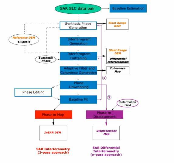
31 Interferometry Workflow

32 From Single Look Complex (SLC) Data to a DEM: Input: Master and Slave SAR SLC Images Output: DEM

33 Baseline Estimation Estimation of the image-pair baseline parameters


34 Interferogram Generation Raw Interferogram Interferogram_int
35 Multi-looked Master and Slave Generation Master_pwr Slave_pwr Looks: 4 azimuth / 1 range Ground-Resolution: ~ 15 x 15 meters


36 Interferogram Flattening With Ellipsoid Interferogram_dint


37 Extraction of a Reference DEM GTOPO DEM_dem (resampled to 15 m)


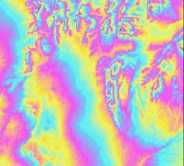
38 Adaptive Filter and Coherence Estimation Interferogram_fint coherence_cc
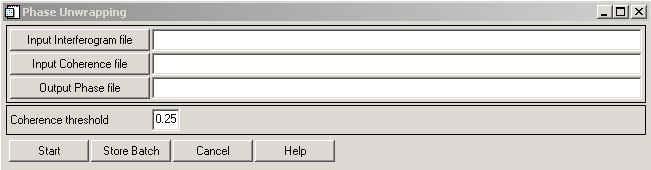
39 Phase Unwrapping Interferogram_upha
40 Phase Editing
, values are automatically")
41 Baseline Fit In case topographic maps were available, GCP values (coordinates and heights) must be entered manually In this example (use of a reference DEM in slant range), values are automatically read

42 Baseline Fit Reflattened Interferogram_dint

43 Phase to Map Conversion
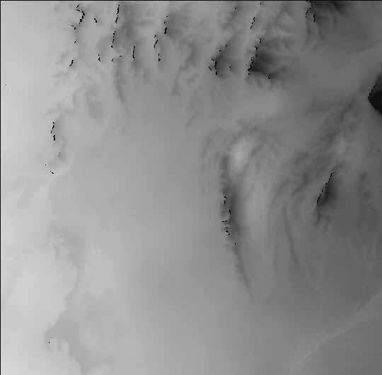
44 Final DEM
SARscape Modules for ENVI
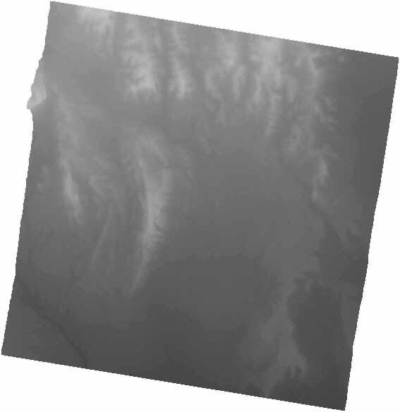
 Visual Information Solutions SARscape Modules for ENVI Read, process, analyze, and output products from SAR data. ENVI. Easy to Use Tools. Proven Functionality. Fast Results. DEM, based on TerraSAR-X-1
Francesco Holecz. TUBE II meeting - 17 June Land Degradation. Land Degradation
 Land Degradation Francesco Holecz Objective To identify and monitor land degraded areas, in particular those related to agricultural and pastoral activities. Following products are generated: Land cover
All rights reserved. ENVI, IDL and Jagwire are trademarks of Exelis, Inc. All other marks are the property of their respective owners.
 SAR Analysis Made Easy with SARscape 5.1 All rights reserved. ENVI, IDL and Jagwire are trademarks of Exelis, Inc. All other marks are the property of their respective owners. 2014, Exelis Visual Information
RESERVOIR MONITORING USING RADAR SATELLITES
 RESERVOIR MONITORING USING RADAR SATELLITES Alain Arnaud, Johanna Granda, Geraint Cooksley ALTAMIRA INFORMATION S.L., Calle Córcega 381-387, E-08037 Barcelona, Spain. Key words: Reservoir monitoring, InSAR,
SARscape 4.1 Supported Sensors/Products (October 2008)
") SARscape 4.1 Supported Sensors/Products (October 2008) ALOS PALSAR (provided by JAXA) In case of RAW (level 1.0) data, import is carried out within the Focusing Module. PALSAR RAW data in CEOS standard
SARscape 4.1 Supported Sensors/Products (October 2008) ALOS PALSAR (provided by JAXA) In case of RAW (level 1.0) data, import is carried out within the Focusing Module. PALSAR RAW data in CEOS standard
SAR Remote Sensing (Microwave Remote Sensing)
") iirs SAR Remote Sensing (Microwave Remote Sensing) Synthetic Aperture Radar Shashi Kumar shashi@iirs.gov.in Electromagnetic Radiation Electromagnetic radiation consists of an electrical field(e) which
iirs SAR Remote Sensing (Microwave Remote Sensing) Synthetic Aperture Radar Shashi Kumar shashi@iirs.gov.in Electromagnetic Radiation Electromagnetic radiation consists of an electrical field(e) which
Fringe 2015 Workshop
 Fringe 2015 Workshop On the Estimation and Interpretation of Sentinel-1 TOPS InSAR Coherence Urs Wegmüller, Maurizio Santoro, Charles Werner and Oliver Cartus Gamma Remote Sensing AG - S1 IWS InSAR and
GFOI Expert Workshop. Sensor interoperability, complementarity, and the temporal component. Francesco Holecz
 GFOI Expert Workshop Sensor interoperability, complementarity, and the temporal component Francesco Holecz Woods Hole Research Centre, MA, USA 10-11 June, 2014 On sensor interoperability Single-date vs.
Synthetic Aperture Radar Interferometry (InSAR) Technique (Lecture I- Tuesday 11 May 2010)
 Technique (Lecture I- Tuesday 11 May 2010)") Synthetic Aperture Radar Interferometry () Technique (Lecture I- Tuesday 11 May 2010) ISNET/CRTEAN Training Course on Synthetic Aperture Radar (SAR) Imagery: Processing, Interpretation and Applications
Synthetic Aperture Radar Interferometry () Technique (Lecture I- Tuesday 11 May 2010) ISNET/CRTEAN Training Course on Synthetic Aperture Radar (SAR) Imagery: Processing, Interpretation and Applications
RADAR INTERFEROMETRY FOR SAFE COAL MINING IN CHINA
 RADAR INTERFEROMETRY FOR SAFE COAL MINING IN CHINA L. Ge a, H.-C. Chang a, A. H. Ng b and C. Rizos a Cooperative Research Centre for Spatial Information School of Surveying & Spatial Information Systems,
TerraSAR-X Applications Guide
 TerraSAR-X Applications Guide Extract: Change Detection and Monitoring: Geospatial / Image Intelligence April 2015 Airbus Defence and Space Geo-Intelligence Programme Line Change Detection and Monitoring:
Monitoring of railroad infrastructure with the use of differential interferometric techniques of SAR data processing
 A.S.Vasileisky, R.I.Shuvalov Monitoring of railroad infrastructure with the use of differential interferometric techniques of SAR data processing From Imagery to Map Digital Photogrammetric Technologies
RADAR ANALYST WORKSTATION MODERN, USER-FRIENDLY RADAR TECHNOLOGY IN ERDAS IMAGINE
 RADAR ANALYST WORKSTATION MODERN, USER-FRIENDLY RADAR TECHNOLOGY IN ERDAS IMAGINE White Paper December 17, 2014 Contents Introduction... 3 IMAGINE Radar Mapping Suite... 3 The Radar Analyst Workstation...
The Radar Ortho Suite is an add-on to Geomatica. It requires Geomatica Core or Geomatica Prime as a pre-requisite.
 Technical Specifications Radar Ortho Suite The Radar Ortho Suite includes rigorous and rational function models developed to compensate for distortions and produce orthorectified radar images. Distortions
IMPACT OF BAQ LEVEL ON INSAR PERFORMANCE OF RADARSAT-2 EXTENDED SWATH BEAM MODES
 IMPACT OF BAQ LEVEL ON INSAR PERFORMANCE OF RADARSAT-2 EXTENDED SWATH BEAM MODES Jayson Eppler (1), Mike Kubanski (1) (1) MDA Systems Ltd., 13800 Commerce Parkway, Richmond, British Columbia, Canada, V6V
Earth Observation and Sensing Technologies: a focus on Radar Imaging Developments. Riccardo Lanari
 Earth Observation and Sensing Technologies: a focus on Radar Imaging Developments Riccardo Lanari Institute for Electromagnetic Sensing of the Environment (IREA) National Research Council of Italy (CNR)
HIGH RESOLUTION DIFFERENTIAL INTERFEROMETRY USING TIME SERIES OF ERS AND ENVISAT SAR DATA
 HIGH RESOLUTION DIFFERENTIAL INTERFEROMETRY USING TIME SERIES OF ERS AND ENVISAT SAR DATA Javier Duro 1, Josep Closa 1, Erlinda Biescas 2, Michele Crosetto 2, Alain Arnaud 1 1 Altamira Information C/ Roger
TerraSAR-X Applications Guide
 TerraSAR-X Applications Guide Extract: Maritime Monitoring: Ship Detection April 2015 Airbus Defence and Space Geo-Intelligence Programme Line Maritime Monitoring: Ship Detection Issue Maritime security
RADAR REMOTE SENSING
 RADAR REMOTE SENSING Jan G.P.W. Clevers & Steven M. de Jong Chapter 8 of L&K 1 Wave theory for the EMS: Section 1.2 of L&K E = electrical field M = magnetic field c = speed of light : propagation direction
Index 275. K Ka-band, 250, 259 Knowledge-based concepts, 110
 Index A Acquisition planning, 225 Across-track, 30, 41, 88, 90 93 Across-track interferometry, 30 Along-track, 3, 10, 19, 41, 88, 90, 91, 93, 94, 103 Along-track interferometry, 41 Ambiguous elevation
Review. Guoqing Sun Department of Geography, University of Maryland ABrief
 Review Guoqing Sun Department of Geography, University of Maryland gsun@glue.umd.edu ABrief Introduction Scattering Mechanisms and Radar Image Characteristics Data Availability Example of Applications
European Space Agency and IPY
 European Space Agency and IPY ESA supports IPY 2007-2008 activities: First ESA step was a dedicated Announcement Opportunity (AO) for EO data provision in support IPY, released in 2006, with data provision
Environmental Impact Assessment of Mining Subsidence by Using Spaceborne Radar Interferometry
 Environmental Impact Assessment of Mining Subsidence by Using Spaceborne Radar Interferometry Hsing-Chung CHANG, Linlin GE and Chris RIZOS, Australia Key words: Mining Subsidence, InSAR, DInSAR, DEM. SUMMARY
Comparison between SAR atmospheric phase screens at 30 by means of ERS and ENVISAT data
 Fringe 2007 - ESA-ESRIN - Frascati, November 28, 2007 Comparison between SAR atmospheric phase screens at 30 by means of ERS and ENVISAT data D. Perissin Politecnico di Milano Tele-Rilevamento Europa -
School of Rural and Surveying Engineering National Technical University of Athens
 Laboratory of Photogrammetry National Technical University of Athens Combined use of spaceborne optical and SAR data Incompatible data sources or a useful procedure? Charalabos Ioannidis, Dimitra Vassilaki
 Performance Comparison between Dual Polarimetric and Fully Polarimetric data for DInSAR Subsidence monitoring Dani Monells, Jordi J. Mallorquí Universitat Politècnica de Catalunya, Departament de Teoria
Satellite Imagery Characteristics, Uses and Delivery to GIS Systems. Wayne Middleton April 2014
 Satellite Imagery Characteristics, Uses and Delivery to GIS Systems Wayne Middleton April 2014 About Geoimage Founded in Brisbane 1988 Leading Independent company Specialists in satellite imagery and geospatial
Introduction to PolSARpro v3.0
 Introduction to PolSARpro v3.0 Eric POTTIER Tuesday 4 September, Lecture D2PA-2 & D2PB-1 04/09/07 Lecture D2PA-2 & D2PB-1 Introduction to PolSARpro v3.0 Eric POTTIER 1 General Presentation of PolSARpro
Envisat and ERS missions: data and services
 FRINGE 2005 Workshop Envisat and ERS missions: and services Henri LAUR Envisat Mission Manager Our top objective: ease access to Earth Observation Common objective for all missions handled by ESA: Envisat,
TanDEM-X: Mission Status & Scientific Contribution
 TanDEM-X: Mission Status & Scientific Contribution Irena Hajnsek 1/2, Gerhard Krieger 1, Kostas Papathanassiou 1, Stefan Baumgartner 1, Marc Rodriguez-Cassola 1, Pau Prats 1, Maria Sanjuan Ferrer 1, Florian
COMPARATIVE ANALYSIS OF INSAR DIGITAL SURFACE MODELS FOR TEST AREA BUCHAREST
 COMPARATIVE ANALYSIS OF INSAR DIGITAL SURFACE MODELS FOR TEST AREA BUCHAREST Iulia Dana (1), Valentin Poncos (2), Delia Teleaga (2) (1) Romanian Space Agency, 21-25 Mendeleev Street, 010362, Bucharest,
The Current Status and Brief Results of Engineering Model for PALSAR-2 onboard ALOS-2 and Science Project
 The Current Status and Brief Results of Engineering Model for PALSAR-2 onboard ALOS-2 and Science Project + The 16 th KC meeting Japan Aerospace Exploration Agency Masanobu Shimada, Yukihiro KANKAKU The
SAR Othorectification and Mosaicking
 White Paper SAR Othorectification and Mosaicking John Wessels: Senior Scientist PCI Geomatics SAR Othorectification and Mosaicking This study describes the high-speed orthorectification and mosaicking
ACTIVE SENSORS RADAR
 ACTIVE SENSORS RADAR RADAR LiDAR: Light Detection And Ranging RADAR: RAdio Detection And Ranging SONAR: SOund Navigation And Ranging Used to image the ocean floor (produce bathymetic maps) and detect objects
So S ft f w t a w re T o T ol Po P ls l A S Rpro v5.0. E. E. Po P ttie i r E.Pottier (2013)
") Software Tool PolSARprov5.0 E. Pottier The Polarimetric Polarimetric SAR Data Pro Processing cessing and Educational Tool v5.0 AIRSAR SETHI DCRS PISAR ESAR EMISAR UAV-SAR FSAR CONVAIR PolSARpro v5.0 Software
Software Tool PolSARprov5.0 E. Pottier The Polarimetric Polarimetric SAR Data Pro Processing cessing and Educational Tool v5.0 AIRSAR SETHI DCRS PISAR ESAR EMISAR UAV-SAR FSAR CONVAIR PolSARpro v5.0 Software
Radar remote sensing from space for monitoring deformations affecting urban areas and infrastructures
 Radar remote sensing from space for monitoring deformations affecting urban areas and infrastructures Riccardo Lanari IREA-CNR Napoli EGU2014, Vienna 30 April, 2014 Why Radar (SAR) Imaging from space?
Monitoring of Bridge Deformation with InSAR: An Experimental Study
 XXIV FIG International Congress 2010 11-16 April 2010 Sydney, Australia Monitoring of Bridge Deformation with InSAR: An Experimental Study Lei Zhang 1, Xiaoli Ding 1 and Zhong Lu 2 1 Department of Land
MODULE 9 LECTURE NOTES 2 ACTIVE MICROWAVE REMOTE SENSING
 MODULE 9 LECTURE NOTES 2 ACTIVE MICROWAVE REMOTE SENSING 1. Introduction Satellite sensors are capable of actively emitting microwaves towards the earth s surface. An active microwave system transmits
SENTINEL-1 Toolbox. Polarimetric Tutorial Issued March 2015 Updated August Luis Veci
 SENTINEL-1 Toolbox Polarimetric Tutorial Issued March 2015 Updated August 2016 Luis Veci Copyright 2015 Array Systems Computing Inc. http://www.array.ca/ http://step.esa.int Polarimetric Tutorial The goal
Damage detection in the 2015 Nepal earthquake using ALOS-2 satellite SAR imagery
 Proceedings of the Tenth Pacific Conference on Earthquake Engineering Building an Earthquake-Resilient Pacific 6-8 November 2015, Sydney, Australia Damage detection in the 2015 Nepal earthquake using ALOS-2
Nazemeh Ashrafianfar, Hans-Peter Hebel and Wolfgang Busch
 MONITORING OF MINING INDUCED LAND SUBSIDENCE - DIFFERENTIAL SAR INTERFEROMETRY AND PERSISTENT SCATTERER INTERFEROMETRY USING TERRASAR-X DATA IN COMPARISON WITH ENVISAT DATA ABSTRACT Nazemeh Ashrafianfar,
ASAR WIDE-SWATH SINGLE-LOOK COMPLEX PRODUCTS: PROCESSING AND EXPLOITATION POTENTIAL
 ASAR WIDE-SWATH SINGLE-LOOK COMPLEX PRODUCTS: PROCESSING AND EXPLOITATION POTENTIAL Ralph Cordey (1), Tim Pearson (2), Yves-Louis Desnos (3), Betlem Rosich-Tell (3) (1) European Space Agency, ESTEC, Keplerlaan
ASAR Training Course, Hanoi, 25 February 7 March 2008 Introduction to Radar Interferometry
 Introduction to Radar Interferometry Presenter: F.Sarti (ESA/ESRIN) 1 Imaging Radar : reminder 2 Physics of radar Potentialities of radar All-weather observation system (active system) Penetration capabilities
SARscape s Coherent Changes Detection Tutorial
 SARscape s Coherent Changes Detection Tutorial Version 1.0 April 2018 1 Index Introduction... 3 Setting Preferences... 4 Data preparation... 5 Input data... 5 DEM Extraction... 5 Single Panels processing...
URBAN MONITORING USING PERSISTENT SCATTERER INSAR AND PHOTOGRAMMETRY
 URBAN MONITORING USING PERSISTENT SCATTERER INSAR AND PHOTOGRAMMETRY Junghum Yu *, Alex Hay-Man Ng, Sungheuk Jung, Linlin Ge, and Chris Rizos. School of Surveying and Spatial Information Systems, University
Contributions of the Remote Sensing by Earth Observation Satellites on Engineering Geology
 10th Asian Regional Conference of IAEG (2015) Contributions of the Remote Sensing by Earth Observation Satellites on Engineering Geology Takeo TADONO (1), Hiroto NAGAI (1), Atsuko NONOMURA (2) and Ryoichi
SAR Interferometry Capabilities of Canada's planned SAR Satellite Constellation
 SAR Interferometry Capabilities of Canada's planned SAR Satellite Constellation Dirk Geudtner, Guy Séguin,, Ralph Girard Canadian Space Agency RADARSAT Follow-on Program CSA is in the middle of a Phase
Microwave remote sensing. Rudi Gens Alaska Satellite Facility Remote Sensing Support Center
 Microwave remote sensing Alaska Satellite Facility Remote Sensing Support Center 1 Remote Sensing Fundamental The entire range of EM radiation constitute the EM Spectrum SAR sensors sense electromagnetic
EE 529 Remote Sensing Techniques. Introduction
 EE 529 Remote Sensing Techniques Introduction Course Contents Radar Imaging Sensors Imaging Sensors Imaging Algorithms Imaging Algorithms Course Contents (Cont( Cont d) Simulated Raw Data y r Processing
TerraSAR-X and TanDEM-X: Revolution in Spaceborne Radar
 TerraSAR-X and TanDEM-X: Revolution in Spaceborne Radar Ralf Düring, Fifamè N. Koudogbo, and Marco Weber, Infoterra GmbH, 88039 Friedrichshafen, Germany INTRODUCTION While Earth Observation from space
Trainings and capacity buildings of space
 Trainings and capacity buildings of space technology, GIS and SAR products development for disaster management for DAN Dr. Masahiko NAGAI, Prof. Ryosuke Shibasaki Center for Spatial Information Science,
RADARSAT-2 Modes and Applications
 RADARSAT-2 Modes and Applications Gordon Staples MDA Geospatial Services February 6, 2017 1 Introduction RADARSAT-2 was developed to meet operational needs via a versatile space segment and a responsive
Warren Cartwright, Product Manager MDA Geospatial Services, Canada
 Advanced InSAR Techniques for Urban Infrastructure Monitoring Warren Cartwright, Product Manager MDA Geospatial Services, Canada www.mdacorporation.com RESTRICTION ON USE, PUBLICATION OR DISCLOSURE OF
PALSAR SCANSAR SCANSAR Interferometry
 PALSAR SCANSAR SCANSAR Interferometry Masanobu Shimada Japan Aerospace Exploration Agency Earth Observation Research Center ALOS PI symposium, Greece Nov. 6 2008 1 Introduction L-band PALSAR strip mode
remote sensing? What are the remote sensing principles behind these Definition
 Introduction to remote sensing: Content (1/2) Definition: photogrammetry and remote sensing (PRS) Radiation sources: solar radiation (passive optical RS) earth emission (passive microwave or thermal infrared
Development of a Ground-based Synthetic Aperture Radar System for Highly Repeatable Measurements
 Development of a Ground-based Synthetic Aperture Radar System for Highly Repeatable Measurements Hoonyol LEE, Seong-Jun CHO, Nak-Hoon SUNG and Jung-Ho KIM Department of Geophysics, Kangwon National University
MULTI-CHANNEL SAR EXPERIMENTS FROM THE SPACE AND FROM GROUND: POTENTIAL EVOLUTION OF PRESENT GENERATION SPACEBORNE SAR
 3 nd International Workshop on Science and Applications of SAR Polarimetry and Polarimetric Interferometry POLinSAR 2007 January 25, 2007 ESA/ESRIN Frascati, Italy MULTI-CHANNEL SAR EXPERIMENTS FROM THE
Playa del Rey, California InSAR Ground Deformation Monitoring Interim Report H
 Playa del Rey, California InSAR Ground Deformation Monitoring Interim Report H Ref.: RV-14524 Doc.: CM-168-01 January 31, 2013 SUBMITTED TO: Southern California Gas Company 555 W. Fifth Street (Mail Location
ERS/ENVISAT ASAR Data Products and Services
 ERS/ENVISAT ASAR Data Products and Services Andrea Celentano Business Manager celentan@eurimage.com What is Eurimage? Founded in 1989 Current shareholders: Since 1989 Commercial Partner of the European
CEGEG046 / GEOG3051 Principles & Practice of Remote Sensing (PPRS) 8: RADAR 1
 8: RADAR 1") CEGEG046 / GEOG3051 Principles & Practice of Remote Sensing (PPRS) 8: RADAR 1 Dr. Mathias (Mat) Disney UCL Geography Office: 113, Pearson Building Tel: 7670 05921 Email: mdisney@ucl.geog.ac.uk www.geog.ucl.ac.uk/~mdisney
CEGEG046 / GEOG3051 Principles & Practice of Remote Sensing (PPRS) 8: RADAR 1 Dr. Mathias (Mat) Disney UCL Geography Office: 113, Pearson Building Tel: 7670 05921 Email: mdisney@ucl.geog.ac.uk www.geog.ucl.ac.uk/~mdisney
Forest Resources Assessment using Synthe c Aperture Radar
 Forest Resources Assessment using Synthe c Aperture Radar Project Background F RA-SAR 2010 was initiated to support the Forest Resources Assessment (FRA) of the United Nations Food and Agriculture Organization
SAR Remote Sensing. Introduction into SAR. Data characteristics, challenges, and applications.
 SAR Remote Sensing Introduction into SAR. Data characteristics, challenges, and applications. PD Dr. habil. Christian Thiel, Friedrich-Schiller-University Jena DLR-HR Jena & Friedrich-Schiller-University
Introduction to radar. interferometry
 Introduction to radar Introduction to Radar Interferometry interferometry Presenter: F.Sarti (ESA/ESRIN) With kind contribution by the Radar Department of CNES All-weather observation system (active system)
The Role of RADARSAT-2 for Flood and Agriculture Monitoring
 The Role of RADARSAT-2 for Flood and Agriculture Monitoring Gordon Staples MDA Richmond, BC, CANADA gstaples@mda.ca RESTRICTION ON USE, PUBLICATION OR DISCLOSURE OF PROPRETIARY INFORMATION This document
MODULE 7 LECTURE NOTES 3 SHUTTLE RADAR TOPOGRAPHIC MISSION DATA
 MODULE 7 LECTURE NOTES 3 SHUTTLE RADAR TOPOGRAPHIC MISSION DATA 1. Introduction Availability of a reasonably accurate elevation information for many parts of the world was once very much limited. Dense
Principles of Remote Sensing. Shuttle Radar Topography Mission S R T M. Michiel Damen. Dept. Earth Systems Analysis
 Principles of Remote Sensing Shuttle Radar Topography Mission S R T M Michiel Damen Dept. Earth Systems Analysis Contents Present problems with DEMs Advantage of SRTM Cell size Mission and system Radar
Affordable space based radar for homeland security
 Changing the economics of space Affordable space based radar for homeland security Adam Baker Brent Abbott Phil Whittaker Rachel Bird Luis Gomes Summary Why Radar? However: Radar data is expensive Users
21-Sep-11. Outline. InSAR monitoring of CO2 sequestration - Complications. Enhanced solution (novel spatiotemporal atmospheric filtering)
") Pushing the accuracy limit for CO2 sequestration monitoring: Statistically optimal spatio-temporal removal of the atmospheric component from InSAR Networks Bernhard Rabus Jayson Eppler MacDonald Dettwiler
Pushing the accuracy limit for CO2 sequestration monitoring: Statistically optimal spatio-temporal removal of the atmospheric component from InSAR Networks Bernhard Rabus Jayson Eppler MacDonald Dettwiler
Co-ReSyF RA lecture: Vessel detection and oil spill detection
 This project has received funding from the European Union s Horizon 2020 Research and Innovation Programme under grant agreement no 687289 Co-ReSyF RA lecture: Vessel detection and oil spill detection
SAR Multi-Temporal Applications
 SAR Multi-Temporal Applications 83230359-DOC-TAS-EN-001 Contents 2 Advantages of SAR Remote Sensing Technology All weather any time Frequencies and polarisations Interferometry and 3D mapping Change Detection
Satellite Assessment and Monitoring for Pavement Management
 CAIT-UTC-NC4 Satellite Assessment and Monitoring for Pavement Management Final Report November 2015 Ardeshir Fagrhi, Ph.D. Professor Mingxin Li, Ph.D. Research Associate II Abdulkadir Ozden Graduate Research
ENVI Orthorectification Module
 ENVI Orthorectification Module Orthorectify your imagery quickly and easily. CREASO - your partner for visual information solutions Rigorous Orthorectification. Simple Workflow. Trusted Method. The Need
High resolution ground deformations monitoring by COSMO-SkyMed PSP SAR interferometry
 High resolution ground deformations monitoring by COSMO-SkyMed PSP SAR interferometry Mario Costantini e-geos - an ASI/Telespazio Company, Rome, Italy mario.costantini@e-geos.it Summary COSMO-SkyMed satellite
ENVI Orthorectification Module
 Visual Information Solutions ENVI Orthorectification Module Orthorectify Your Imagery Quickly and Easily. Rigorous Orthorectification. Simple Workflow. Trusted Method. The Need for Orthorectification Satellite
SAR Imagery: Airborne or Spaceborne? Presenter: M. Lorraine Tighe PhD
 SAR Imagery: Airborne or Spaceborne? Presenter: M. Lorraine Tighe PhD Introduction The geospatial community has seen a plethora of spaceborne SAR imagery systems where there are now extensive archives
Microwave Remote Sensing (1)
") Microwave Remote Sensing (1) Microwave sensing encompasses both active and passive forms of remote sensing. The microwave portion of the spectrum covers the range from approximately 1cm to 1m in wavelength.
Microwave Remote Sensing (1) Microwave sensing encompasses both active and passive forms of remote sensing. The microwave portion of the spectrum covers the range from approximately 1cm to 1m in wavelength.
Change detection in cultural landscapes
 9-11 November 2015 ESA-ESRIN, Frascati (Rome), Italy 3 rd ESA-EARSeL Course on Remote Sensing for Archaeology Day 3 Change detection in cultural landscapes DeodatoTapete (1,2) & Francesca Cigna (1,2) (1)
Detection of a Point Target Movement with SAR Interferometry
 Journal of the Korean Society of Remote Sensing, Vol.16, No.4, 2000, pp.355~365 Detection of a Point Target Movement with SAR Interferometry Jung-Hee Jun* and Min-Ho Ka** Agency for Defence Development*,
Sentinel-1 Overview. Dr. Andrea Minchella
 Dr. Andrea Minchella 21-22/01/2016 ESA SNAP-Sentinel-1 Training Course Satellite Applications Catapult - Electron Building, Harwell, Oxfordshire Contents Sentinel-1 Mission Sentinel-1 SAR Modes Sentinel-1
Urban tunneling and the advantages of using InSAR SPN satellite technology to detect and monitor surface deformation effects
 Urban tunneling and the advantages of using InSAR SPN satellite technology to detect and monitor surface deformation effects María de Faragó 1, Geraint Cooksley 1 1 Altamira Information, Spain ABSTRACT
Sentinel-1 System Overview
 Sentinel-1 System Overview Dirk Geudtner, Rámon Torres, Paul Snoeij, Malcolm Davidson European Space Agency, ESTEC Global Monitoring for Environment and Security (GMES) EU-led program aiming at providing
Introduction to Microwave Remote Sensing
 Introduction to Microwave Remote Sensing lain H. Woodhouse The University of Edinburgh Scotland Taylor & Francis Taylor & Francis Group Boca Raton London New York A CRC title, part of the Taylor & Francis
Concept of the future L-band SAR mission for wide swath SAR observation
 Concept of the future SAR mission for wide swath SAR observation A.Karasawa 1, Y.Okada 1, Y.Yokota 1, S.Nakamura 1 1) Mitsubishi Electric Corporation 1 Outline 1:Development of SAR systems in MELCO 2:Development
TerraSAR-X Image Product Guide
 [Texte] TerraSAR-X Image Product Guide Page 1 of 24 Ref.: OP00xxxxxxxxxx Commercial in Confidence 1 Introduction TerraSAR-X and TanDEM-X are commercial German Synthetic Aperture Radar (SAR) Earth observation
Development of the Technology of Utilization of Airborne Synthetic Aperture Radar (SAR)
") Development of the Technology of Utilization of Airborne Synthetic Aperture Radar (SAR) Mamoru Koarai, Kouichi Moteki, Nobuyuki Watanabe, Takaki Okatani,Youko Yamada and Kaoru Matsuo Geographical Survey
Development of the Technology of Utilization of Airborne Synthetic Aperture Radar (SAR) Mamoru Koarai, Kouichi Moteki, Nobuyuki Watanabe, Takaki Okatani,Youko Yamada and Kaoru Matsuo Geographical Survey
RADARSAT-2 Program Update Daniel De Lisle Canadian Space Agency
 RADARSAT-2 Program Update Daniel De Lisle Canadian Space Agency Presentation outline RADARSAT-1 Update RADARSAT-2 Mission description Mission Objectives System Characteristics Data Commercialization/Allocation
Mangrove Forest Distributions of the World
 Mangrove Forest Distributions of the World Chandra Giri - ARTS/EROS/USGS Ochieng, E. - United Nations Environment Programme Larry Tieszen USGS EROS Zhiliang Zhu - USGS Ashbindu Singh United Nations Environment
The TerraSAR-L System and Mission Objectives
 The TerraSAR-L System and Mission Objectives Manfred Zink & Ramon Torres TerraSAR Project, ESA-ESTEC Keplerlaan 1, 2200 AG, Noordwijk, The Netherlands Tel: +31 71565 3038, Fax: +31 71565 3191, Email: Manfred.Zink@esa.int
Client: Statens vegvesen, Region midt County: Sør Trondelag
 Geological Survey of Norway N-7441 Trondheim, Norway REPORT Report no.: 2004.043 ISSN 0800-3416 Grading: Open Title: Preliminary analysis of InSAR data over Trondheim with respect to future road development
THE NASA/JPL AIRBORNE SYNTHETIC APERTURE RADAR SYSTEM. Yunling Lou, Yunjin Kim, and Jakob van Zyl
 THE NASA/JPL AIRBORNE SYNTHETIC APERTURE RADAR SYSTEM Yunling Lou, Yunjin Kim, and Jakob van Zyl Jet Propulsion Laboratory California Institute of Technology 4800 Oak Grove Drive, MS 300-243 Pasadena,
Remote Sensing. Ch. 3 Microwaves (Part 1 of 2)
") Remote Sensing Ch. 3 Microwaves (Part 1 of 2) 3.1 Introduction 3.2 Radar Basics 3.3 Viewing Geometry and Spatial Resolution 3.4 Radar Image Distortions 3.1 Introduction Microwave (1cm to 1m in wavelength)
Remote Sensing Ch. 3 Microwaves (Part 1 of 2) 3.1 Introduction 3.2 Radar Basics 3.3 Viewing Geometry and Spatial Resolution 3.4 Radar Image Distortions 3.1 Introduction Microwave (1cm to 1m in wavelength)
PSInSAR VALIDATION BY MEANS OF A BLIND EXPERIMENT USING DIHEDRAL REFLECTORS
 PSInSAR VALIDATION BY MEANS OF A BLIND EXPERIMENT USING DIHEDRAL REFLECTORS G. Savio (1), A. Ferretti (1) (2), F. Novali (1), S. Musazzi (3), C. Prati (2), F. Rocca (2) (1) Tele-Rilevamento Europa T.R.E.
SAR missions for oceanography at the European Space Agency
 SAR missions for oceanography at the European Space Agency ERS-1, ERS-2, Envisat, Sentinel-1A, Sentinel-1B, ESA 3 rd Party Missions (ALOS) Prepared by ESA teams and ESA supporting companies ESA and SAR
The TerraSAR-L Interferometric Mission Objectives
 The TerraSAR-L Interferometric Mission Objectives Manfred Zink TerraSAR Project, ESA-ESTEC Keplerlaan 1, 2200 AG, Noordwijk, The Netherlands Tel: +31 71565 3038, Fax: +31 71565 3191, Email: Manfred.Zink@esa.int
ENVISAT ASAR DATA PROCESSING
 ASAR data processing with GAMMA Software, Version of 20-Jun-2003 GAMMA SOFTWARE VALIDATION REPORT: ENVISAT ASAR DATA PROCESSING Urs Wegmüller, Tazio Strozzi, Charles Werner and Andreas Wiesmann Gamma Remote
Remote sensing image correction
 Remote sensing image correction Introductory readings remote sensing http://www.microimages.com/documentation/tutorials/introrse.pdf 1 Preprocessing Digital Image Processing of satellite images can be
Generation of Fine Resolution DEM at Test Areas in Alaska Using ERS SAR Tandem Pairs and Precise Orbital Data *
 Generation of Fine Resolution DEM at Test Areas in Alaska Using ERS SAR Tandem Pairs and Precise Orbital Data * O. Lawlor, T. Logan, R. Guritz, R. Fatland, S. Li, Z. Wang, and C. Olmsted Alaska SAR Facility
UNOSAT Satellite Imagery and GIS Solutions for DRR and Emergency Management
 UNOSAT Satellite Imagery and GIS Solutions for DRR and Emergency Management Francesco Pisano Director, Research, Technology Applications & Knowledge Systems January 2013 Introduction to UNOSAT 2 About
ANALYZING TERRASAR-X AND COSMO-SKYMED HIGH-RESOLUTION SAR DATA OF URBAN AREAS
 ANALYZING TERRASAR-X AND COSMO-SKYMED HIGH-RESOLUTION SAR DATA OF URBAN AREAS Mingsheng Liao*, Timo Balz, Lu Zhang, Yuanyuan Pei, Houjun Jiang State Key Laboratory of Information Engineering in Surveying,
THREE-DIMENSIONAL MAPPING USING BOTH AIRBORNE AND SPACEBORNE IFSAR TECHNOLOGIES ABSTRACT INTRODUCTION
 THREE-DIMENSIONAL MAPPING USING BOTH AIRBORNE AND SPACEBORNE IFSAR TECHNOLOGIES Trina Kuuskivi Manager of Value Added Products and Services, Intermap Technologies Corp. 2 Gurdwara Rd, Suite 200, Ottawa,