Satellite Imagery Characteristics, Uses and Delivery to GIS Systems. Wayne Middleton April 2014
|
|
|
- Miles Smith
- 6 years ago
- Views:
Transcription


1 Satellite Imagery Characteristics, Uses and Delivery to GIS Systems Wayne Middleton April 2014

2 About Geoimage Founded in Brisbane 1988 Leading Independent company Specialists in satellite imagery and geospatial solutions

3 Geoimage Imagery Partners Providing access to the largest range of satellite imagery in Australia 19 satellite/satellite systems
4 Geoimage Partners Image Processing Software Specialty Imagery Products Spatial Data Management
5 Outline Review of optical and radar satellite imagery, their characteristics and derived products Application examples and delivery into GIS software

6 Electromagnetic spectrum Gamma Ray to Radio Waves

7 JAXA/METI DigitalGlobe Geoimage Pan-sharpening
8 Optical Satellite Imagery Passive sensor - senses reflected light from ground surfaces using the sun as illumination source Categorized by spatial resolution: Medium (5 to 30 metres) High (>1 to 5 metres) Very high (Sub-metre to 1m)
9 Optical Satellite Imagery Worldwide coverage at some scale Imagery of inaccessible areas Repeat coverage Large historical archive

10 Map-up of sub-metre pan-sharpened multispectral data assessed as <10% cloud cover and acquired in 2012 and to May 2013 All VHR vendors to that date shown Pleiades 1A and 1B on top
11 Optical Satellite Imagery Programmable Monoscopic or stereo capture (for DEM generation) Spectral analysis Cloud affected Best resolution is 0.5 metres
12 Optical Satellite Imagery Medium resolution (5m to 30m): Landsat 1 to 5 (decommissioned), Landsat 7 (faulty) Landsat 8 ASTER (SWIR decommissioned) SPOT 1 to 4 (decommissioned) SPOT 5 Multispectral ALOS AVNIR-2 (decommissioned) SPOT 6 Multispectral SPOT 7 Multispectral (to be launched in 2014)

13 ClearView TM PNG
14 Optical Satellite Imagery High resolution (>1m to 5m): SPOT 5 and 6 Panchromatic and pan-sharpened multispectral SPOT 7 Panchromatic and pan-sharpened multispectral (to be launched in 2014) ALOS PRISM (panchromatic) and pan-sharpened AVNIR-2 (multispectral) (decommissioned) VHR Multispectral (e.g. GE-1 2m BGRN multispectral) RapidEye

15 Manilla International Airport SPOT 6 PS-imagery Airbus D&S

16 Manilla International Airport SPOT 6 PS-imagery Airbus D&S
17 Optical Satellite Imagery Very high resolution (Sub-metre to 1m): IKONOS the oldest (1999) QuickBird WorldView-1, -2 and -3 (to be launched in 2014) GeoEye-1 Pleiades Kompsat-1, -2 and -3 (limited Australian archive) SkySat-1 and -2 (to be launched in 2014) include highdefinition video

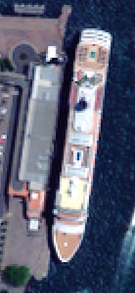
18 WorldView-2 PS-imagery DigitalGlobe

19 WorldView-2 PS-imagery DigitalGlobe

20 WorldView-2 PS-imagery DigitalGlobe

21 DigitalGlobe 2014 WorldView-2 Brisbane (50cm)
22 Derived Products

23 Iran Pleiades imagery and DEM Airbus D&S

24 Iran Pleiades imagery and DEM Airbus D&S

25 Iran Pleiades imagery and DEM Airbus D&S

26 Iran Pleiades imagery and DEM Airbus D&S
27 Radar Satellite Imagery Active sensor - provides own energy to detect features on the ground, can penetrate cloud & be acquired at night Categorized by wavelength: L-Band (15cm to 30cm) C-Band (3.75cm to 7.5cm) X-Band (2.4cm to 3.75cm)

28 Radar Satellite Imagery Worldwide coverage at some wavelength Imagery of inaccessible areas and/or areas affected by constant cloud cover Repeat coverage Programmable or in archive Large historical archive

29 PALSAR imagery JAXA/METI versus Landsat imagery over PNG

30 PALSAR imagery JAXA/METI versus Landsat imagery over PNG

31 PALSAR imagery JAXA/METI versus Landsat imagery over PNG

32 PALSAR imagery JAXA/METI versus Landsat imagery over PNG

33 PALSAR imagery JAXA/METI versus Landsat imagery over PNG
34 Radar Satellite Imagery L-Band (15cm to 30cm): JERS (decommissioned) ALOS PALSAR (decommissioned)

35 PALSAR FBS outlines over Central Papua JAXA/METI

36 Composite PALSAR Fine Beam Mode over Central Papua JAXA/METI
: Radarsat-1 and -2 ERS-1 and -2 (decommissioned) Envisat (decommissioned) X-Band (2.")
37 Radar Satellite Imagery C-Band (3.75cm to 7.5cm): Radarsat-1 and -2 ERS-1 and -2 (decommissioned) Envisat (decommissioned) X-Band (2.4cm to 3.75cm): TerraSAR-X / TanDEM-X COSMO-SkyMed
38 Applications
39 Application Examples Medium Resolution Optical Satellite Imagery ASTER Bands in VNIR, SWIR and TIR useful for spectral mapping for mineral exploration Availability limited to pre May 2007

40 Application Examples Medium Resolution Optical Satellite Imagery Electromagnetic spectrum Visible to SWIR
41 ASTER Spectral Processing
42 ASTER Spectral Processing

43 ASTER Spectral Processing
44 ASTER Spectral Processing

45 ASTER Spectral Processing

46 ASTER Spectral Processing

47 ASTER Spectral Processing

48 ASTER Spectral Processing


49 Application Examples High Resolution Optical Satellite Imagery SPOTMaps existing 2.5m pansharpened natural colour mosaic Dates vary from 2009 to 2012 over Australia Low cloud, accurate (5m to 10m CE90), low-cost, background image Uses include vector extraction to cost effectively map or update roads, hydrology, other natural and man-made features

50 NSW SPOTMaps imagery Airbus D&S

51 NSW SPOTMaps imagery Airbus D&S
52 Application Examples Very High Resolution Optical Satellite Imagery GeoEye-1 0.5m stereo fresh capture DEM generation at 1m resolution 0.5m pan-sharpened background imagery DEM colour drape Terrain shaded relief showing discrete height classes

53 Chile GeoEye-1 PS RGB imagery DigitalGlobe 2013

54 Chile GeoEye-1 PS RGB imagery DigitalGlobe 2013

55 Chile GeoEye-1 PS RGB imagery DigitalGlobe 2013

56 Chile GeoEye-1 PS RGB imagery DigitalGlobe 2013

57 Chile GeoEye-1 PS RGB imagery draped over generated DEM DigitalGlobe 2013

58 Chile GeoEye-1 PS RGB imagery draped over generated DEM DigitalGlobe 2013

59 Chile GeoEye-1 PS RGB imagery draped over generated DEM DigitalGlobe 2013

60 Chile GeoEye-1 PS RGB imagery draped over generated DEM DigitalGlobe 2013

61 Chile GeoEye-1 PS RGB imagery draped over generated DEM DigitalGlobe 2013

62 Chile GeoEye-1 PS RGB imagery draped over generated DEM DigitalGlobe 2013

63 Chile GeoEye-1 PS RGB imagery draped over generated DEM DigitalGlobe 2013

64 Chile GeoEye-1 Terrain Shaded Relief DigitalGlobe 2013

65 Chile GeoEye-1 Terrain Shaded Relief DigitalGlobe 2013

66 Chile GeoEye-1 Terrain Shaded Relief DigitalGlobe 2013
67 Application Examples Radar Satellite Imagery Global Seeps Database ( Airbus D&S) of off-shore oil slicks Constructed by systematically screening the world s offshore basins using a wide range of archive and fresh capture radar satellite data including ERS-1 and -2, TerraSAR-X, Radarsat-1 and 2, JERS-1, Envisat and PALSAR and optical satellite data including Landsat and ASTER

68 Current Australian Coverage Airbus D&S

69 Application Examples Radar Satellite Imagery Radar is used in preference to optical because it can penetrate cloud, can be acquired at night and is well suited to discriminate oil on the sea surface
70 Application Examples Radar Satellite Imagery Archive currently includes over interpreted scenes Database is continually updated, over 3000 new scenes were added in 2013 Slicks are characterized and ranked as probable natural seepage or man-made pollution based on a 3-part methodology
71 Application Examples Radar Satellite Imagery GIS-ready deliverables Description and interpretation results of radar scenes Slick interpretation results Ship and oil rig/platform locations Thumbnail images of each slick Radar images Geodatabase relationships between raster and vector data ArcGIS toolbar
 Airbus")
72 25m chip over oil slick feature (left), 100m full radar satellite scene (right) Airbus D&S

73 Seep Browser ArcGIS toolbar Airbus D&S

74 Thank you
TechTime New Mapping Tools for Transportation Engineering
 GeoEye-1 Stereo Satellite Imagery Presented by Karl Kliparchuk, M.Sc., GISP kkliparchuk@mcelhanney.com 604-683-8521 All satellite imagery are copyright GeoEye Corp GeoEye-1 About GeoEye Corp Headquarters:
Specialists in Satellite Imagery and Geospatial Solutions. Satellite Imagery a valuable tool for the Mining Industry
 Specialists in Satellite Imagery and Geospatial Solutions Satellite Imagery a valuable tool for the Mining Industry Satellites Deciding which is the best satellite imagery for your application? Geoimage
Module 3 Introduction to GIS. Lecture 8 GIS data acquisition
 Module 3 Introduction to GIS Lecture 8 GIS data acquisition GIS workflow Data acquisition (geospatial data input) GPS Remote sensing (satellites, UAV s) LiDAR Digitized maps Attribute Data Management Data
The studies began when the Tiros satellites (1960) provided man s first synoptic view of the Earth s weather systems.
 provided man s first synoptic view of the Earth s weather systems.") Remote sensing of the Earth from orbital altitudes was recognized in the mid-1960 s as a potential technique for obtaining information important for the effective use and conservation of natural resources.
Remote sensing of the Earth from orbital altitudes was recognized in the mid-1960 s as a potential technique for obtaining information important for the effective use and conservation of natural resources.
Aral Sea profile Selection of area 24 February April May 1998
 250 km Aral Sea profile 1960 1960 1985 1986 1987 1988 1989 1990 1991 1992 1993 1994 1995 1996 1997 1998 2010? Selection of area Area of interest Kzyl-Orda Dried seabed 185 km Syrdarya river Aral Sea Salt
9/12/2011. Training Course Remote Sensing Basic Theory & Image Processing Methods September 2011
 Training Course Remote Sensing Basic Theory & Image Processing Methods 19 23 September 2011 Popular Remote Sensing Sensors & their Selection Michiel Damen (September 2011) damen@itc.nl 1 Overview Low resolution
Introduction to KOMPSAT
 Introduction to KOMPSAT September, 2016 1 CONTENTS 01 Introduction of SIIS 02 KOMPSAT Constellation 03 New : KOMPSAT-3 50 cm 04 New : KOMPSAT-3A 2 KOMPSAT Constellation KOMPSAT series National space program
UNOSAT Satellite Imagery and GIS Solutions for DRR and Emergency Management
 UNOSAT Satellite Imagery and GIS Solutions for DRR and Emergency Management Francesco Pisano Director, Research, Technology Applications & Knowledge Systems January 2013 Introduction to UNOSAT 2 About
Introduction to Remote Sensing Fundamentals of Satellite Remote Sensing. Mads Olander Rasmussen
 Introduction to Remote Sensing Fundamentals of Satellite Remote Sensing Mads Olander Rasmussen (mora@dhi-gras.com) 01. Introduction to Remote Sensing DHI What is remote sensing? the art, science, and technology
The Normal Baseline. Dick Gent Law of the Sea Division UK Hydrographic Office
 The Normal Baseline Dick Gent Law of the Sea Division UK Hydrographic Office 2 The normal baseline for measuring the breadth of the territorial sea is the low water line along the coast as marked on large
REMOTE SENSING INTERPRETATION
 REMOTE SENSING INTERPRETATION Jan Clevers Centre for Geo-Information - WU Remote Sensing --> RS Sensor at a distance EARTH OBSERVATION EM energy Earth RS is a tool; one of the sources of information! 1
1. Theory of remote sensing and spectrum
 1. Theory of remote sensing and spectrum 7 August 2014 ONUMA Takumi Outline of Presentation Electromagnetic wave and wavelength Sensor type Spectrum Spatial resolution Spectral resolution Mineral mapping
Verification Tool for Safeguards. Satellite Imagery IAEA. Technical Seminar for Diplomats. Karen Steinmaus, SGIM-ICA. Vienna, 3-5 February 2009
 Technical Seminar for Diplomats Vienna, 3-5 February 2009 Satellite Imagery as Verification Tool for Safeguards Karen Steinmaus, SGIM-ICA International Atomic Energy Agency The Satellite Imagery Analysis
Ten years of remote sensing advancement & the research outcome of the CRC-AGIP Lab
 Ten years of remote sensing advancement & the research outcome of the CRC-AGIP Lab Dr. Yun Zhang Canada Research Chair Laboratory in Advanced Geomatics Image Processing (CRC-AGIP Lab) Department of Geodesy
DIGITALGLOBE SATELLITE IMAGERY AND CLOUD SERVICES FOR SUGARCANE MAPPING
 DIGITALGLOBE SATELLITE IMAGERY AND CLOUD SERVICES FOR SUGARCANE MAPPING PRESENTER: DILLON PANIZZOLO (TECHNICAL MANAGER) COMPANY: GEO DATA DESIGN DATE: 18 TH AUGUST 2015 SASTA Congress Sugar Cane Mapping
GIS Data Collection. Remote Sensing
 GIS Data Collection Remote Sensing Data Collection Remote sensing Introduction Concepts Spectral signatures Resolutions: spectral, spatial, temporal Digital image processing (classification) Other systems
Application and potentials of RADAR and LiDAR technologies for forest carbon assessment in Pacific Island Countries
 Application and potentials of RADAR and LiDAR technologies for forest carbon assessment in Pacific Island Countries June 19th, 2012 PNGFA-JICA Workshop Masamichi HARAGUCHI (Kokusai Kogyo Co., Ltd.) Consultant
Lecture 6: Multispectral Earth Resource Satellites. The University at Albany Fall 2018 Geography and Planning
 Lecture 6: Multispectral Earth Resource Satellites The University at Albany Fall 2018 Geography and Planning Outline SPOT program and other moderate resolution systems High resolution satellite systems
Specialists in Satellite Imagery and GeoSpatial Solutions STOP PRESS
 NOVEMBER, 2010 Happy Days Are Here Again Discounts Galore! The recent performance of the Aussie Dollar has seen a rush on the very high resolution satellite sales as clients take advantage of the reduced
Introduction to Remote Sensing
 Introduction to Remote Sensing Spatial, spectral, temporal resolutions Image display alternatives Vegetation Indices Image classifications Image change detections Accuracy assessment Satellites & Air-Photos
COMPARISON OF INFORMATION CONTENTS OF HIGH RESOLUTION SPACE IMAGES
 COMPARISON OF INFORMATION CONTENTS OF HIGH RESOLUTION SPACE IMAGES H. Topan*, G. Büyüksalih*, K. Jacobsen ** * Karaelmas University Zonguldak, Turkey ** University of Hannover, Germany htopan@karaelmas.edu.tr,
An Introduction to Geomatics. Prepared by: Dr. Maher A. El-Hallaq خاص بطلبة مساق مقدمة في علم. Associate Professor of Surveying IUG
 An Introduction to Geomatics خاص بطلبة مساق مقدمة في علم الجيوماتكس Prepared by: Dr. Maher A. El-Hallaq Associate Professor of Surveying IUG 1 Airborne Imagery Dr. Maher A. El-Hallaq Associate Professor
Image interpretation. Aliens create Indian Head with an ipod? Badlands Guardian (CBC) This feature can be found 300 KMs SE of Calgary.
 This feature can be found 300 KMs SE of Calgary.") Image interpretation Aliens create Indian Head with an ipod? Badlands Guardian (CBC) This feature can be found 300 KMs SE of Calgary. 50 1 N 110 7 W Milestones in the History of Remote Sensing 19 th century
Image interpretation Aliens create Indian Head with an ipod? Badlands Guardian (CBC) This feature can be found 300 KMs SE of Calgary. 50 1 N 110 7 W Milestones in the History of Remote Sensing 19 th century
Introduction of Satellite Remote Sensing
 Introduction of Satellite Remote Sensing Spatial Resolution (Pixel size) Spectral Resolution (Bands) Resolutions of Remote Sensing 1. Spatial (what area and how detailed) 2. Spectral (what colors bands)
School of Rural and Surveying Engineering National Technical University of Athens
 Laboratory of Photogrammetry National Technical University of Athens Combined use of spaceborne optical and SAR data Incompatible data sources or a useful procedure? Charalabos Ioannidis, Dimitra Vassilaki
The studies began when the Tiros satellites (1960) provided man s first synoptic view of the Earth s weather systems.
 provided man s first synoptic view of the Earth s weather systems.") Remote sensing of the Earth from orbital altitudes was recognized in the mid-1960 s as a potential technique for obtaining information important for the effective use and conservation of natural resources.
Remote sensing of the Earth from orbital altitudes was recognized in the mid-1960 s as a potential technique for obtaining information important for the effective use and conservation of natural resources.
An Introduction to Remote Sensing & GIS. Introduction
 An Introduction to Remote Sensing & GIS Introduction Remote sensing is the measurement of object properties on Earth s surface using data acquired from aircraft and satellites. It attempts to measure something
Topographic mapping from space K. Jacobsen*, G. Büyüksalih**
 Topographic mapping from space K. Jacobsen*, G. Büyüksalih** * Institute of Photogrammetry and Geoinformation, Leibniz University Hannover ** BIMTAS, Altunizade-Istanbul, Turkey KEYWORDS: WorldView-1,
GEOSPATIAL CLOUD COMPUTING SOLUTION APPLIED TO NEW CALEDONIA FOREST MONITORING
 GEOSPATIAL CLOUD COMPUTING SOLUTION APPLIED TO NEW CALEDONIA FOREST MONITORING Worldview-3 30 cm Forgotten Coast New Caledonia DigitalGLobe 2016, Distribution and processing BLUECHAM SAS BLUECHAM SAS 101
Copernicus Introduction Lisbon, Portugal 13 th & 14 th February 2014
 Copernicus Introduction Lisbon, Portugal 13 th & 14 th February 2014 Contents Introduction GMES Copernicus Six thematic areas Infrastructure Space data An introduction to Remote Sensing In-situ data Applications
CURRENT SCENARIO AND CHALLENGES IN THE ANALYSIS OF MULTITEMPORAL REMOTE SENSING IMAGES
 Remote Sensing Laboratory Dept. of Information Engineering and Computer Science University of Trento Via Sommarive, 14, I-38123 Povo, Trento, Italy CURRENT SCENARIO AND CHALLENGES IN THE ANALYSIS OF MULTITEMPORAL
Files Used in This Tutorial. Background. Calibrating Images Tutorial
 In this tutorial, you will calibrate a QuickBird Level-1 image to spectral radiance and reflectance while learning about the various metadata fields that ENVI uses to perform calibration. This tutorial
remote sensing? What are the remote sensing principles behind these Definition
 Introduction to remote sensing: Content (1/2) Definition: photogrammetry and remote sensing (PRS) Radiation sources: solar radiation (passive optical RS) earth emission (passive microwave or thermal infrared
NON-PHOTOGRAPHIC SYSTEMS: Multispectral Scanners Medium and coarse resolution sensor comparisons: Landsat, SPOT, AVHRR and MODIS
 NON-PHOTOGRAPHIC SYSTEMS: Multispectral Scanners Medium and coarse resolution sensor comparisons: Landsat, SPOT, AVHRR and MODIS CLASSIFICATION OF NONPHOTOGRAPHIC REMOTE SENSORS PASSIVE ACTIVE DIGITAL
The world s most advanced constellation
 The DigitalGlobe Constellation The world s most advanced constellation of very high-resolution satellites The world s most advanced constellation The DigitalGlobe constellation of high-resolution satellites
DigitalGlobe High Resolution Satellite Imagery
 DigitalGlobe High Resolution Satellite Imagery KIAN KANG, SALES MANAGER, SOUTH EAST ASIA & TAIWAN See a better world. DigitalGlobe Overview Over 1,300 employees spanning the globe H E A D Q UA R T E R
Data Sharing Issues in SE Asia
 Data Sharing Issues in SE Asia Kandasri Limpakom User Service and Business Development Office About GISTDA THEOS & Its Applications GISTDA s Data Sharing Geo-Informatics and Space Technology Development
HARRIS GEOSPATIAL MARKETPLACE. HarrisGeospatial.com
 HARRIS GEOSPATIAL MARKETPLACE HarrisGeospatial.com Satellite image of Washington, D.C. Image courtesy of DigitalGlobe GET IT ALL IN ONE PLACE Data for Any Project Map Products Vis/Sim Products Geospatial
Managing Imagery and Raster Data. Peter Becker
 Managing Imagery and Raster Data Peter Becker ArcGIS is a Comprehensive Imagery Platform Empowering you to make informed decisions System of Engagement System of Insight Extract Information from Imagery
Operational Space-Based Imaging Systems
 Operational Space-Based Imaging Systems R E M O T E S E N S I N G & G E O S PAT I A L A N A LY S I S L A B D O I : 2 0 A U G U S T, 2 0 1 6 Earth Observation Systems U.S. or foreign government systems
FEDERAL SPACE AGENCY SOVZOND JSC компания «Совзонд»
 FEDERAL SPACE AGENCY Resurs-DK.satellite SOVZOND JSC SPECIFICATIONS Launch date June 15, 2006 Carrier vehicle Soyuz Orbit Elliptical Altitude 360-604 km Revisit frequency (at nadir) 6 days Inclination
CHARACTERISTICS OF REMOTELY SENSED IMAGERY. Radiometric Resolution
 CHARACTERISTICS OF REMOTELY SENSED IMAGERY Radiometric Resolution There are a number of ways in which images can differ. One set of important differences relate to the various resolutions that images express.
ROLE OF SATELLITE DATA APPLICATION IN CADASTRAL MAP AND DIGITIZATION OF LAND RECORDS DR.T. RAVISANKAR GROUP HEAD (LRUMG) RSAA/NRSC/ISRO /DOS HYDERABAD
 RSAA/NRSC/ISRO /DOS HYDERABAD") ROLE OF SATELLITE DATA APPLICATION IN CADASTRAL MAP AND DIGITIZATION OF LAND RECORDS DR.T. RAVISANKAR GROUP HEAD (LRUMG) RSAA/NRSC/ISRO /DOS HYDERABAD WORKSHOP on Best Practices under National Land Records
ROLE OF SATELLITE DATA APPLICATION IN CADASTRAL MAP AND DIGITIZATION OF LAND RECORDS DR.T. RAVISANKAR GROUP HEAD (LRUMG) RSAA/NRSC/ISRO /DOS HYDERABAD WORKSHOP on Best Practices under National Land Records
Designing a Remote Sensing Project. Many factors to consider: here lumped into 12 sections hold on!! first some basic concepts
 Designing a Remote Sensing Project Many factors to consider: here lumped into 12 sections hold on!! first some basic concepts DVC Geography 160 Introduction to Remote Sensing J. Ellis DigitalGlobe (2006)
Title of presentation runs here on two lines / Arial Regular 30 pt
 Title of presentation runs here on two lines / Arial Regular 30 pt Subtitle goes here / Arial Regular 20 pt Airbus Defense and Space Geo-Intelligence PIONEERING THE FUTURE TOGETHER Name Here / Arial Regular
Data Warehouse Phase 2 CORE Datasets Status 15 th May 2018
 Data Warehouse Phase 2 CORE Datasets Status 15 th May 2018 The document presents the status of the open CORE datasets, for which data provision is on-going. Once closed, content of the datasets can be
Abstract Quickbird Vs Aerial photos in identifying man-made objects
 Abstract Quickbird Vs Aerial s in identifying man-made objects Abdullah Mah abdullah.mah@aramco.com Remote Sensing Group, emap Division Integrated Solutions Services Department (ISSD) Saudi Aramco, Dhahran
INFORMATION CONTENT ANALYSIS FROM VERY HIGH RESOLUTION OPTICAL SPACE IMAGERY FOR UPDATING SPATIAL DATABASE
 INFORMATION CONTENT ANALYSIS FROM VERY HIGH RESOLUTION OPTICAL SPACE IMAGERY FOR UPDATING SPATIAL DATABASE M. Alkan a, * a Department of Geomatics, Faculty of Civil Engineering, Yıldız Technical University,
Introduction to Remote Sensing
 Introduction to Remote Sensing Outline Remote Sensing Defined Resolution Electromagnetic Energy (EMR) Types Interpretation Applications Remote Sensing Defined Remote Sensing is: The art and science of
Remote sensing in archaeology from optical to lidar. Krištof Oštir ModeLTER Scientific Research Centre of the Slovenian Academy of Sciences and Arts
 Remote sensing in archaeology from optical to lidar Krištof Oštir ModeLTER Scientific Research Centre of the Slovenian Academy of Sciences and Arts Introduction Optical remote sensing Systems Search for
9/12/2011. Training Course Remote Sensing Basic Theory & Image Processing Methods September 2011
 Training Course Remote Sensing Basic Theory & Image Processing Methods 19 23 September 2011 Introduction to Remote Sensing Michiel Damen (September 2011) damen@itc.nl 1 Overview Some definitions Remote
All rights reserved. ENVI, IDL and Jagwire are trademarks of Exelis, Inc. All other marks are the property of their respective owners.
 SAR Analysis Made Easy with SARscape 5.1 All rights reserved. ENVI, IDL and Jagwire are trademarks of Exelis, Inc. All other marks are the property of their respective owners. 2014, Exelis Visual Information
Remote Sensing and GIS
 Remote Sensing and GIS Atmosphere Reflected radiation, e.g. Visible Emitted radiation, e.g. Infrared Backscattered radiation, e.g. Radar (λ) Visible TIR Radar & Microwave 11/9/2017 Geo327G/386G, U Texas,
Remote Sensing Platforms
 Types of Platforms Lighter-than-air Remote Sensing Platforms Free floating balloons Restricted by atmospheric conditions Used to acquire meteorological/atmospheric data Blimps/dirigibles Major role - news
CHARACTERISTICS OF VERY HIGH RESOLUTION OPTICAL SATELLITES FOR TOPOGRAPHIC MAPPING
 CHARACTERISTICS OF VERY HIGH RESOLUTION OPTICAL SATELLITES FOR TOPOGRAPHIC MAPPING K. Jacobsen Leibniz University Hannover, Institute of Photogrammetry and Geoinformation jacobsen@ipi.uni-hannover.de Commission
Using Freely Available. Remote Sensing to Create a More Powerful GIS
 Using Freely Available Government Data and Remote Sensing to Create a More Powerful GIS All rights reserved. ENVI, E3De, IAS, and IDL are trademarks of Exelis, Inc. All other marks are the property of
Geomatica OrthoEngine Orthorectifying SPOT6 data
 Geomatica OrthoEngine Orthorectifying SPOT6 data On September 9, 2012, SPOT 6 was launched adding to the constellation of Earthimaging satellites designed to provide 1.5m high-resolution data. The architecture
Final Examination Introduction to Remote Sensing. Time: 1.5 hrs Max. Marks: 50. Section-I (50 x 1 = 50 Marks)
") Final Examination Introduction to Remote Sensing Time: 1.5 hrs Max. Marks: 50 Note: Attempt all questions. Section-I (50 x 1 = 50 Marks) 1... is the technology of acquiring information about the Earth's
Final Examination Introduction to Remote Sensing Time: 1.5 hrs Max. Marks: 50 Note: Attempt all questions. Section-I (50 x 1 = 50 Marks) 1... is the technology of acquiring information about the Earth's
Kongsberg Satellite Services, KSAT
 SvalSat, Earth Station at 78 North Kongsberg Satellite Services, KSAT Making Sense of Space Sigmund Dehli International Sales Manager WORLD CLASS through people, technology and dedication My plan KSAT
Atmospheric Correction (including ATCOR)
") Technical Specifications Atmospheric Correction (including ATCOR) The data obtained by optical satellite sensors with high spatial resolution has become an invaluable tool for many groups interested in
Technical Specifications Atmospheric Correction (including ATCOR) The data obtained by optical satellite sensors with high spatial resolution has become an invaluable tool for many groups interested in
Advanced Techniques in Urban Remote Sensing
 Advanced Techniques in Urban Remote Sensing Manfred Ehlers Institute for Geoinformatics and Remote Sensing (IGF) University of Osnabrueck, Germany mehlers@igf.uni-osnabrueck.de Contents Urban Remote Sensing:
The DigitalGlobe Constellation. World s Largest Sub-Meter High Resolution Satellite Constellation
 The DigitalGlobe Constellation World s Largest Sub-Meter High Resolution Satellite Constellation The DigitalGlobe Constellation The DigitalGlobe constellation of high resolution satellites offers incredible
High Resolution Imaging Satellite Systems
 High Resolution Imaging Satellite Systems K. Jacobsen University of Hannover, Germany Keywords: high resolution space sensors, SAR ABSTRACT: The number of existing and announced high and very high resolution
Imagery Archive Works
 USDA How Satellite the Imagery USDA s Archive Satellite Imagery Archive Works A. What is the USDA Satellite Imagery Archive? B. What are the benefits of participating in the USDA Archive? C. What types
Warren Cartwright, Product Manager MDA Geospatial Services, Canada
 Advanced InSAR Techniques for Urban Infrastructure Monitoring Warren Cartwright, Product Manager MDA Geospatial Services, Canada www.mdacorporation.com RESTRICTION ON USE, PUBLICATION OR DISCLOSURE OF
LPIS Orthoimagery An assessment of the Bing imagery for LPIS purpose
 LPIS Orthoimagery An assessment of the Bing imagery for LPIS purpose Slavko Lemajić Wim Devos, Pavel Milenov GeoCAP Action - MARS Unit - JRC Ispra Tallinn, 24 th November 2011 Outline JRC`s Ortho specifications
What can we check with VHR Pan and HR multispectral imagery?
 2008 CwRS Campaign Kick-off meeting, Ispra, 03-04 April 2008 1 What can we check with VHR Pan and HR multispectral imagery? Pavel MILENOV GeoCAP, Agriculture Unit, JRC 2008 CwRS Campaign Kick-off meeting,
REMOTE SENSING FOR FLOOD HAZARD STUDIES.
 REMOTE SENSING FOR FLOOD HAZARD STUDIES. OPTICAL SENSORS. 1 DRS. NANETTE C. KINGMA 1 Optical Remote Sensing for flood hazard studies. 2 2 Floods & use of remote sensing. Floods often leaves its imprint
Kaukokartoitus ympäristön tilan seurannassa. Remote sensing for environmental monitoring
 Kaukokartoitus ympäristön tilan seurannassa Remote sensing for environmental monitoring Arto Vuorela 1 Contents Traditional applications, governmental activities etc. for environmental monitoring New or
Ge111A Remote Sensing and GIS Lecture
 Ge111A Remote Sensing and GIS Lecture Remote Sensing - many different geophysical data sets. We concentrate on the following: Imagery (optical and radar) Topography Geographical Information Systems (GIS)
Summary of the VHR image acquisition Campaign 2014 and new sensors for 2015
 Summary of the VHR image acquisition Campaign 2014 and new sensors for 2015 Michaela Neumann, George Ellis, Samuel Bärisch, Blanka Vajsova 19 November 2014, Dresden 20th MARS Conference Presentation Outline
Price List. October 20 th, of 52. PRICE LIST October 20th 2017 BDS-COM
 Price List October 20 th, 2017 1 of 52 INDEX INDEX... 2 COSMO-SKYMED... 4 WORLDVIEW-1/2/3/4... 10 GEOEYE-1... 10 QUICKBIRD... 10 IKONOS... 10 RADARSAT-1... 19 RADARSAT-2... 19 IRS P6... 25 IRS P5... 25
Remote Sensing for Rangeland Applications
 Remote Sensing for Rangeland Applications Jay Angerer Ecological Training June 16, 2012 Remote Sensing The term "remote sensing," first used in the United States in the 1950s by Ms. Evelyn Pruitt of the
How to Access Imagery and Carry Out Remote Sensing Analysis Using Landsat Data in a Browser
 How to Access Imagery and Carry Out Remote Sensing Analysis Using Landsat Data in a Browser Including Introduction to Remote Sensing Concepts Based on: igett Remote Sensing Concept Modules and GeoTech
RADAR (RAdio Detection And Ranging)
") RADAR (RAdio Detection And Ranging) CLASSIFICATION OF NONPHOTOGRAPHIC REMOTE SENSORS PASSIVE ACTIVE DIGITAL CAMERA THERMAL (e.g. TIMS) VIDEO CAMERA MULTI- SPECTRAL SCANNERS VISIBLE & NIR MICROWAVE Real
RADAR (RAdio Detection And Ranging) CLASSIFICATION OF NONPHOTOGRAPHIC REMOTE SENSORS PASSIVE ACTIVE DIGITAL CAMERA THERMAL (e.g. TIMS) VIDEO CAMERA MULTI- SPECTRAL SCANNERS VISIBLE & NIR MICROWAVE Real
EO Data Today and Application Fields. Denise Petala
 EO Data Today and Application Fields Denise Petala ! IGD GROUP AE "Infotop SA, Geomet Ltd., Dynatools Ltd. "Equipment and know how in many application fields, from surveying till EO data and RS. # Leica,
Blacksburg, VA July 24 th 30 th, 2010 Remote Sensing Page 1. A condensed overview. For our purposes
 A condensed overview George McLeod Prepared by: With support from: NSF DUE-0903270 in partnership with: Geospatial Technician Education Through Virginia s Community Colleges (GTEVCC) The art and science
EE 529 Remote Sensing Techniques. Introduction
 EE 529 Remote Sensing Techniques Introduction Course Contents Radar Imaging Sensors Imaging Sensors Imaging Algorithms Imaging Algorithms Course Contents (Cont( Cont d) Simulated Raw Data y r Processing
Geology, Exploration, and WorldView-3 SWIR Kumar Navulur, PhD
 Geology, Exploration, and WorldView-3 SWIR Kumar Navulur, PhD Mt Everest Digital Elevation Model 0.5 m WorldView 2 2m False Color IR Drape DigitalGlobe Proprietary. DigitalGlobe. All rights reserved. Agenda
366 Glossary. Popular method for scale drawings in a computer similar to GIS but without the necessity for spatial referencing CEP
 366 Glossary GISci Glossary ASCII ASTER American Standard Code for Information Interchange Advanced Spaceborne Thermal Emission and Reflection Radiometer Computer Aided Design Circular Error Probability
Airbus Airbus Defence and Space - Intelligence. Price List North America
 Airbus Airbus Defence and Space - Intelligence Price List North America Effective: January 1, 2018 Pléiades and SPOT 1-7 Archive Prices are per square kilometer. Prices and minimum order size apply for
HYPERSPECTRAL IMAGERY FOR SAFEGUARDS APPLICATIONS. International Atomic Energy Agency, Vienna, Austria
 HYPERSPECTRAL IMAGERY FOR SAFEGUARDS APPLICATIONS G. A. Borstad 1, Leslie N. Brown 1, Q.S. Bob Truong 2, R. Kelley, 3 G. Healey, 3 J.-P. Paquette, 3 K. Staenz 4, and R. Neville 4 1 Borstad Associates Ltd.,
SARscape for ENVI. A Complete SAR Analysis Solution
 SARscape for ENVI A Complete SAR Analysis Solution IDL and ENVI A Foundation for SARscape IDL The Data Analysis & Visualization Platform Data Access: IDL supports virtually every data format, type and
Microwave Remote Sensing (1)
") Microwave Remote Sensing (1) Microwave sensing encompasses both active and passive forms of remote sensing. The microwave portion of the spectrum covers the range from approximately 1cm to 1m in wavelength.
Microwave Remote Sensing (1) Microwave sensing encompasses both active and passive forms of remote sensing. The microwave portion of the spectrum covers the range from approximately 1cm to 1m in wavelength.
Observing Dry-Fallen Intertidal Flats in the German Bight Using ALOS PALSAR Together With Other Remote Sensing Sensors
 Observing Dry-Fallen Intertidal Flats in the German Bight Using ALOS PALSAR Together With Other Remote Sensing Sensors Martin Gade, Institut für Meereskunde & Kerstin Stelzer Brockmann Consult Outline
WHAT IS NEXT IN EARTH OBSERVATION. SkyMed Mission
 WHAT IS NEXT IN EARTH OBSERVATION COSMO-SkyMed SkyMed Mission Paolo Ammendola Italian Space Agency Florence, Sept. 19, 2001 ammendola@asi asi.it THE NEEDS Market studies indicate that the value of the
PROGRESS IN ADDRESSING SCIENCE GOALS FOR GLACIER OBSERVATIONS BY MEANS OF SAR. Frank Paul & Thomas Nagler
 PROGRESS IN ADDRESSING SCIENCE GOALS FOR GLACIER OBSERVATIONS BY MEANS OF SAR Frank Paul & Thomas Nagler SAR Coordination Working Group Meeting, 13/11/2016 Observed glacier products and sensors Product
New Constellations, New Capabilities, and Future Opportunities
 New Constellations, New Capabilities, and Future Opportunities PETER KINNE REGIONAL DIRECTOR DIGITALGLOBE See a better world. The Past HOW FAR HAVE WE COME? See a better world. 1783 - Take couple of French
News on Image Acquisition for Campaign 2008
 Ispra, 3-4/04/2008 CwRS KO meeting 1 News on Image Acquisition for Campaign 2008 Pär Johan Åstrand, Maria Erlandsson, annian Zhu CID Action Ispra, 3-4/04/2008 CwRS KO meeting 2 Outline of presentation
European Space Imaging
 European Space Imaging Use cases of Very High Resolution satellite imagery in support of crop management GEO-CRADLE Regional Workshop, 7/12/2017, Tunis Arnaud Durand adurand@euspaceimaging.com COMPANY
Image Acquisition Campaign 2008
 Madrid, 12-14 November, 2007 Geomatics in Support of the CAP 1 Image Acquisition Campaign 2008 Pär Johan Åstrand, Maria Erlandsson Mihaela Fotin, Cherith Aspinall JRC, CID JRC, CID Madrid, 12-14 November,
HIGH RESOLUTION SATELLITE IMAGING SYSTEMS - OVERVIEW
 HIGH RESOLUTION SATELLITE IMAGING SYSTEMS - OVERVIEW K. Jacobsen University of Hannover jacobsen@ipi.uni-hannover.de KEY WORDS: Satellite, optical sensors, SAR ABSTRACT: More and more high and very high
US Commercial Imaging Satellites
 US Commercial Imaging Satellites In the early 1990s, Russia began selling 2-meter resolution product from its archives of collected spy satellite imagery. Some of this product was down-sampled to provide
Remote Sensing Platforms
 Remote Sensing Platforms Remote Sensing Platforms - Introduction Allow observer and/or sensor to be above the target/phenomena of interest Two primary categories Aircraft Spacecraft Each type offers different
Remote Sensing. Ch. 3 Microwaves (Part 1 of 2)
") Remote Sensing Ch. 3 Microwaves (Part 1 of 2) 3.1 Introduction 3.2 Radar Basics 3.3 Viewing Geometry and Spatial Resolution 3.4 Radar Image Distortions 3.1 Introduction Microwave (1cm to 1m in wavelength)
Remote Sensing Ch. 3 Microwaves (Part 1 of 2) 3.1 Introduction 3.2 Radar Basics 3.3 Viewing Geometry and Spatial Resolution 3.4 Radar Image Distortions 3.1 Introduction Microwave (1cm to 1m in wavelength)
DEM GENERATION WITH WORLDVIEW-2 IMAGES
 DEM GENERATION WITH WORLDVIEW-2 IMAGES G. Büyüksalih a, I. Baz a, M. Alkan b, K. Jacobsen c a BIMTAS, Istanbul, Turkey - (gbuyuksalih, ibaz-imp)@yahoo.com b Zonguldak Karaelmas University, Zonguldak, Turkey
European Space Imaging. Your Partner for Very High-Resolution Satellite Imagery GEOGRAPHIC
 European Space Imaging Your Partner for Very High-Resolution Satellite Imagery XVII International User Conference of GeoInformation Systems & Remote Sensing European Space Imaging Your Partner for Very
GMES DA COPERNICUS
 2014 Airbus Defence and Space All rights reserved. The reproduction, distribution and utilization of this document as well as the communication of its contents to others without express authorization is
Geomatica OrthoEngine v10.2 Tutorial Orthorectifying ALOS PRISM Data Rigorous and RPC Modeling
 Geomatica OrthoEngine v10.2 Tutorial Orthorectifying ALOS PRISM Data Rigorous and RPC Modeling ALOS stands for Advanced Land Observing Satellite and was developed by the Japan Aerospace Exploration Agency
Satellite imagery for CWRS from Irish perspective. Speaker: Aleksandra Kocon Author: Aleksandra Kocon
 Satellite imagery for CWRS from Irish perspective Speaker: Aleksandra Kocon Author: Aleksandra Kocon aleksandra@icon.ie Introduction Long acquisition windows / windows fitting with crop cycle problem Main