Geomatica OrthoEngine Orthorectifying SPOT6 data
|
|
|
- Neal Adams
- 5 years ago
- Views:
Transcription

1 Geomatica OrthoEngine Orthorectifying SPOT6 data On September 9, 2012, SPOT 6 was launched adding to the constellation of Earthimaging satellites designed to provide 1.5m high-resolution data. The architecture of SPOT 6 is similar to that of the Pleiades satellites, both orbiting at an altitude of 694km. SPOT 6 has an imaging swath of 60kms and is suited for mapping, surveillance and monitoring. The following is a brief tutorial showing a step by step procedure for pansharpening and orthorectifying SPOT 6 imagery using Geomatica OrthoEngine Initial Project Setup 1. Open the Geomatica 2013 OrthoEngine application 2. In OrthoEngine a. Click File > New 3. Give your project a Filename, Name and Description a. Select Optical Satellite Modeling as the Math Modeling Method Select Rational Function (Extract from image) under Options. The Rational Function Method (RFM) has been the most popular geometric correction method in orthorectifying high resolution images. This method uses the RPCs provided with the satellite data to perform orthorectification. At this point Toutin s Model can also be Page 1


2 selected. If you are manually collecting GCP s using Toutin s Model, a minimum of 6 GCP s are required. b. Click OK 4. Input the appropriate Output projection and GCP projection information for your project Page 2


3 Pan Sharpening It is always preferable to perform the pan-sharpening process before geometric correction if a pan-sharpened orthorectified image is desired. This method works for most areas with gentle terrain. Performing pan-sharpening after geometric correction often results in small misalignments between the ortho data due to the accuracy of GCPs and DEMs used in the orthorectification process. 5. Click on Utilities > Merge/Pansharp Multispectral Image 6. Select the Multispectral image in the dataset. Select the DIM_SPOT6_.xml file a. Select the Panchromatic image. Select the DIM_SPOT6_.xml file b. Select the output filename and location for the output PIX file c. Click Pansharp d. When the pansharp process is complete click Yes when asked to add the scene into the project Page 3
 is capable of taking a multispectral image and its")


4 Figure 1a: SPOT6 MS image Figure1b: SPOT6 PAN image About the output PCI s Geomatica award winning pansharpening algorithm (Co-developed with UNB) is capable of taking a multispectral image and its coincident/co-registered panchromatic pair and produce outstanding pansharpened results. The output is a beautifully sharp high resolution multispectral image with the resolution of the panchromatic image. The pansharpened process takes a high resolution panchromatic image and a lower resolution multispectral image and produces a high resolution multispectral image (same resolution of panchromatic image) with very sharp edges. Page 4
 and a digital elevation model (DEM) is required. 7. Select Data Input as the Processing step a.")
5 Figure 1c: SPOT6 PCI pan-sharpened image Geometric Correction In order to leverage the SPOT 6 images for applications such as GIS, it is necessary to orthorectify the images. A geometric model, ground control points (GCPs) and a digital elevation model (DEM) is required. 7. Select Data Input as the Processing step a. Click Open a new or existing image Page 5


6 b. Click New Image c. Navigate to the location of the data. Select the DIM_SPOT6_.xml file if you wish to use the raw imagery. If you pansharpend the imagery as shown in the steps above, the pansharpened PIX file will already be added to the project. Skip to step 8. d. Select Yes when asked if you want to import the data file to a PIX file for optimized processing e. Select a file name and location for your output PIX file f. Select Yes when asked if you want to create overviews now 8. In the OrthoEngine toolbar select GCP/TP Collection as the Processing step a. Select Collect GCP s Manually Note: GCP s can be collected automatically using collect GCP s automatically from the GCP/TP Collection Processing step. Automatic tie point collection can also be used without collecting any GCPs. Page 6

7 b. Collect GCP s for the project using manual entry, from geocoded images, vectors, chip databases, digitizing tablet or a text file. 9. In the OrthoEngine toolbar select Ortho Generation as the Processing step a. Click Schedule ortho generation b. Move the Available images to the Images to process window c. Select an output file name and location for the ortho image d. Select a DEM file e. Select a Sampling interval f. Change the Resampling method to Cubic g. Click Generate Orthos Page 7


8 10. To view the completed ortho select File > Image View on the OrthoEngine Toolbar Page 8
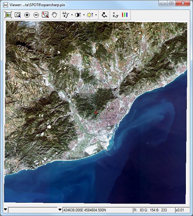
9 Page 9
Geomatica OrthoEngine V10.3 Tutorial. Orthorectifying AVNIR-2 Data Rigorous and RPC Modeling
 Geomatica OrthoEngine V10.3 Tutorial Orthorectifying AVNIR-2 Data Rigorous and RPC Modeling AVNIR-2 stands for Advanced Visible and Near Infrared Radiometer Type 2. It is a successor of AVNIR-1 and is
Geomatica OrthoEngine v10.2 Tutorial DEM Extraction of GeoEye-1 Data
 Geomatica OrthoEngine v10.2 Tutorial DEM Extraction of GeoEye-1 Data GeoEye 1, launched on September 06, 2008 is the highest resolution commercial earth imaging satellite available till date. GeoEye-1
Landsat 8 Pansharpen and Mosaic Geomatica 2015 Tutorial
 Landsat 8 Pansharpen and Mosaic Geomatica 2015 Tutorial On February 11, 2013, Landsat 8 was launched adding to the constellation of Earth imaging satellites. It is the seventh satellite to reach orbit
Geomatica OrthoEngine v10.2 Tutorial Orthorectifying ALOS PRISM Data Rigorous and RPC Modeling
 Geomatica OrthoEngine v10.2 Tutorial Orthorectifying ALOS PRISM Data Rigorous and RPC Modeling ALOS stands for Advanced Land Observing Satellite and was developed by the Japan Aerospace Exploration Agency
Planet Labs Inc 2017 Page 2
 SKYSAT IMAGERY PRODUCT SPECIFICATION: ORTHO SCENE LAST UPDATED JUNE 2017 SALES@PLANET.COM PLANET.COM Disclaimer This document is designed as a general guideline for customers interested in acquiring Planet
Using the Chip Database
 Using the Chip Database TUTORIAL A chip database is a collection of image chips or subsetted images where each image has a GCP associated with it. A chip database can be useful when orthorectifying different
Geomatica OrthoEngine v10.2 Tutorial DEM Extraction of WorldView-1 Data
 Geomatica OrthoEngine v10.2 Tutorial DEM Extraction of WorldView-1 Data WorldView 1, launched on September 18, 2007, offers a panchromatic imagery at a very high resolution of 50 cm at nadir. The key benefits
The Airphoto Ortho Suite is an add-on to Geomatica. It requires Geomatica Core or Geomatica Prime as a pre-requisite.
 Airphoto Ortho Suite The Airphoto Ortho Suite includes rigorous models used to correct the geometry of analogue and digital/video cameras and to produce orthorectified air photos. These models compensate
The Radar Ortho Suite is an add-on to Geomatica. It requires Geomatica Core or Geomatica Prime as a pre-requisite.
 Technical Specifications Radar Ortho Suite The Radar Ortho Suite includes rigorous and rational function models developed to compensate for distortions and produce orthorectified radar images. Distortions
Satellite Ortho Suite
 Technical Specifications Satellite Ortho Suite The Satellite Ortho Suite includes rigorous and rational function models developed to compensate for distortions and produce orthorectified satellite images
Summary of the VHR image acquisition Campaign 2014 and new sensors for 2015
 Summary of the VHR image acquisition Campaign 2014 and new sensors for 2015 Michaela Neumann, George Ellis, Samuel Bärisch, Blanka Vajsova 19 November 2014, Dresden 20th MARS Conference Presentation Outline
PLANET IMAGERY PRODUCT SPECIFICATIONS PLANET.COM
 PLANET IMAGERY PRODUCT SPECIFICATIONS SUPPORT@PLANET.COM PLANET.COM LAST UPDATED JANUARY 2018 TABLE OF CONTENTS LIST OF FIGURES 3 LIST OF TABLES 4 GLOSSARY 5 1. OVERVIEW OF DOCUMENT 7 1.1 Company Overview
News on Image Acquisition for the CwRS Campaign new sensors and changes
 Control Methods Workshop: 6-8 / 4 / 2009 [CwRS KO Meeting Campaign 2009] 1 News on Image Acquisition for the CwRS Campaign 2009 - new sensors and changes Pär Johan Åstrand, Joanna Nowak, Maria Erlandsson
ENVI Tutorial: Orthorectifying Aerial Photographs
 ENVI Tutorial: Orthorectifying Aerial Photographs Table of Contents OVERVIEW OF THIS TUTORIAL...2 ORTHORECTIFYING AERIAL PHOTOGRAPHS IN ENVI...2 Building the interior orientation...3 Building the exterior
Image Fusion. Pan Sharpening. Pan Sharpening. Pan Sharpening: ENVI. Multi-spectral and PAN. Magsud Mehdiyev Geoinfomatics Center, AIT
 1 Image Fusion Sensor Merging Magsud Mehdiyev Geoinfomatics Center, AIT Image Fusion is a combination of two or more different images to form a new image by using certain algorithms. ( Pohl et al 1998)
FEDERAL SPACE AGENCY SOVZOND JSC компания «Совзонд»
 FEDERAL SPACE AGENCY Resurs-DK.satellite SOVZOND JSC SPECIFICATIONS Launch date June 15, 2006 Carrier vehicle Soyuz Orbit Elliptical Altitude 360-604 km Revisit frequency (at nadir) 6 days Inclination
TEMPORAL ANALYSIS OF MULTI EPOCH LANDSAT GEOCOVER IMAGES IN ZONGULDAK TESTFIELD
 TEMPORAL ANALYSIS OF MULTI EPOCH LANDSAT GEOCOVER IMAGES IN ZONGULDAK TESTFIELD Şahin, H. a*, Oruç, M. a, Büyüksalih, G. a a Zonguldak Karaelmas University, Zonguldak, Turkey - (sahin@karaelmas.edu.tr,
Processing Aster Data for Atmospheric Correction Geomatica 2014 Tutorial
 The Advanced Spaceborne Thermal Emission and Reflection Radiometer (ASTER) sensor is part of five sensor systems on board Terra. Terra is a satellite that was launched on December 18, 1999 at Vandenberg
Accurate, Detailed Elevation
 White Paper Accurate, Detailed Elevation LEVERAGE HIGH RESOLUTION SATELLITE STEREO IMAGERY TO DERIVE DETAILED, ACCURATE ELEVATION MODELS IN INNACCESSIBLE AREAS Dr. Waldir Paradella and Dr. Philip CHeng
KOMPSAT-2 DIRECT SENSOR MODELING AND GEOMETRIC CALIBRATION/VALIDATION
 KOMPSAT-2 DIRECT SENSOR MODELING AND GEOMETRIC CALIBRATION/VALIDATION Doo Chun Seo a, *, Ji Yeon Yang a, Dong Han Lee a, Jeong Heon Song a, Hyo Suk Lim a a KARI, Satellite Information Research Institute,
PLANET IMAGERY PRODUCT SPECIFICATION: PLANETSCOPE & RAPIDEYE
 PLANET IMAGERY PRODUCT SPECIFICATION: PLANETSCOPE & RAPIDEYE LAST UPDATED OCTOBER 2016 SALES@PLANET.COM PLANET.COM Table of Contents LIST OF FIGURES 3 LIST OF TABLES 3 GLOSSARY 5 1. OVERVIEW OF DOCUMENT
SAR Othorectification and Mosaicking
 White Paper SAR Othorectification and Mosaicking John Wessels: Senior Scientist PCI Geomatics SAR Othorectification and Mosaicking This study describes the high-speed orthorectification and mosaicking
DIFFERENTIAL APPROACH FOR MAP REVISION FROM NEW MULTI-RESOLUTION SATELLITE IMAGERY AND EXISTING TOPOGRAPHIC DATA
 DIFFERENTIAL APPROACH FOR MAP REVISION FROM NEW MULTI-RESOLUTION SATELLITE IMAGERY AND EXISTING TOPOGRAPHIC DATA Costas ARMENAKIS Centre for Topographic Information - Geomatics Canada 615 Booth Str., Ottawa,
ENVI Orthorectification Module
 ENVI Orthorectification Module Orthorectify your imagery quickly and easily. CREASO - your partner for visual information solutions Rigorous Orthorectification. Simple Workflow. Trusted Method. The Need
Geometric Quality Testing of the WorldView-2 Image Data Acquired over the JRC Maussane Test Site using ERDAS LPS, PCI Geomatics and
 Geometric Quality Testing of the WorldView-2 Image Data Acquired over the JRC Maussane Test Site using ERDAS LPS, PCI Geomatics and Keystone digital photogrammetry software packages Inital Findings Joanna
News on Image Acquisition for Campaign 2008
 Ispra, 3-4/04/2008 CwRS KO meeting 1 News on Image Acquisition for Campaign 2008 Pär Johan Åstrand, Maria Erlandsson, annian Zhu CID Action Ispra, 3-4/04/2008 CwRS KO meeting 2 Outline of presentation
Topographic mapping from space K. Jacobsen*, G. Büyüksalih**
 Topographic mapping from space K. Jacobsen*, G. Büyüksalih** * Institute of Photogrammetry and Geoinformation, Leibniz University Hannover ** BIMTAS, Altunizade-Istanbul, Turkey KEYWORDS: WorldView-1,
ENVI Orthorectification Module
 Visual Information Solutions ENVI Orthorectification Module Orthorectify Your Imagery Quickly and Easily. Rigorous Orthorectification. Simple Workflow. Trusted Method. The Need for Orthorectification Satellite
GXL 2015 Technical Description
 GXL 2015 Technical Description Table of Contents SYSTEM ARCHITECTURE... 4 GXL SYSTEM OVERVIEW... 4 GXL SYSTEM COMPONENTS... 5 GXL Processing Server(s)... 5 GXL Controller... 5 GXL Interface (thin Client)...
Satellite Imagery Characteristics, Uses and Delivery to GIS Systems. Wayne Middleton April 2014
 Satellite Imagery Characteristics, Uses and Delivery to GIS Systems Wayne Middleton April 2014 About Geoimage Founded in Brisbane 1988 Leading Independent company Specialists in satellite imagery and geospatial
GMES DA COPERNICUS
 2014 Airbus Defence and Space All rights reserved. The reproduction, distribution and utilization of this document as well as the communication of its contents to others without express authorization is
Comparing geometric and radiometric information from GeoEye-1 and WorldView-2 multispectral imagery
 European Journal of Remote Sensing - 2014, 47: 717-738 doi: 10.5721/EuJRS20144741 Received 20/05/2014, accepted 17/10/2014 European Journal of Remote Sensing An official journal of the Italian Society
TUTORIAL Extraction of Geospatial Information from High Spatial Resolution Optical Satellite Sensors
 TUTORIAL Extraction of Geospatial Information from High Spatial Resolution Optical Satellite Sensors E. Baltsavias 1,L. Zhang 2, D. Holland 3, P.K. Srivastava 4, B. Gopala Krishna 4, T.P. Srinivasan 4
Airbus Airbus Defence and Space - Intelligence. Price List North America
 Airbus Airbus Defence and Space - Intelligence Price List North America Effective: January 1, 2018 Pléiades and SPOT 1-7 Archive Prices are per square kilometer. Prices and minimum order size apply for
Fusion of Heterogeneous Multisensor Data
 Fusion of Heterogeneous Multisensor Data Karsten Schulz, Antje Thiele, Ulrich Thoennessen and Erich Cadario Research Institute for Optronics and Pattern Recognition Gutleuthausstrasse 1 D 76275 Ettlingen
PLANET IMAGERY PRODUCT SPECIFICATION: PLANETSCOPE & RAPIDEYE
 PLANET IMAGERY PRODUCT SPECIFICATION: PLANETSCOPE & RAPIDEYE LAST UPDATED FEBRUARY 2017 SALES@PLANET.COM PLANET.COM Table of Contents LIST OF FIGURES 3 LIST OF TABLES 3 GLOSSARY 5 1. OVERVIEW OF DOCUMENT
Appendix 2: Worked example using GPS
 Appendix 2: Worked example using GPS This appendix will talk the reader through how to use a GPS, get data out of the unit and use that data in the expedition GIS. The specific example used is a simple
What s New in Geomatica 10.1
 What s New in Geomatica 10.1 Table of Contents Geomatica Software Solutions... 1 Introductions to Geomatica 10.1... 1 What's new?... 1 Geomatica 10.1 Improvements... 2 Licensing Changes... 2 PCIDSK Quadtree
Using Imagery for Intelligence Analysis. Jim Michel Renee Bernstein
 Using Imagery for Intelligence Analysis Jim Michel Renee Bernstein Deriving Value from GIS and Imagery Capabilities Evolved Along Separate but Parallel Paths GIS Imagery brings value Imagery Contextual
CHARACTERISTICS OF VERY HIGH RESOLUTION OPTICAL SATELLITES FOR TOPOGRAPHIC MAPPING
 CHARACTERISTICS OF VERY HIGH RESOLUTION OPTICAL SATELLITES FOR TOPOGRAPHIC MAPPING K. Jacobsen Leibniz University Hannover, Institute of Photogrammetry and Geoinformation jacobsen@ipi.uni-hannover.de Commission
INTERNATIONAL JOURNAL OF GEOMATICS AND GEOSCIENCES Volume 2, No 3, 2012
 INTERNATIONAL JOURNAL OF GEOMATICS AND GEOSCIENCES Volume 2, No 3, 2012 Copyright 2010 All rights reserved Integrated Publishing services Research article ISSN 0976 4380 Generation and evaluation of Cartosat
New sensors benchmark report on KOMPSAT-3A
 New sensors benchmark report on KOMPSAT-3A Geometric benchmarking over Maussane test site for CAP purposes Blanka Vajsova Agnieszka Walczynska Samuel Bärisch Pär Johan Åstrand Melanie Rankl 2018 EUR 29331
Title of presentation runs here on two lines / Arial Regular 30 pt
 Title of presentation runs here on two lines / Arial Regular 30 pt Subtitle goes here / Arial Regular 20 pt Airbus Defense and Space Geo-Intelligence PIONEERING THE FUTURE TOGETHER Name Here / Arial Regular
ANNEX IV ERDAS IMAGINE OPERATION MANUAL
 ANNEX IV ERDAS IMAGINE OPERATION MANUAL Table of Contents 1. TOPIC 1 DATA IMPORT...1 1.1. Importing SPOT DATA directly from CDROM... 1 1.2. Importing SPOT (Panchromatic) using GENERIC BINARY... 7 1.3.
Geomatica I Course Guide Version 10.1
 Geomatica I Course Guide Version 10.1 Geomatica Version 10.1 2007 PCI Geomatics Enterprises Inc.. All rights reserved. COPYRIGHT NOTICE Software copyrighted by PCI Geomatics, 50 West Wilmot St., Suite
Files Used in This Tutorial. Background. Calibrating Images Tutorial
 In this tutorial, you will calibrate a QuickBird Level-1 image to spectral radiance and reflectance while learning about the various metadata fields that ENVI uses to perform calibration. This tutorial
DESIS Applications & Processing Extracted from Teledyne & DLR Presentations to JACIE April 14, Ray Perkins, Teledyne Brown Engineering
 DESIS Applications & Processing Extracted from Teledyne & DLR Presentations to JACIE April 14, 2016 Ray Perkins, Teledyne Brown Engineering 1 Presentation Agenda Imaging Spectroscopy Applications of DESIS
Increasing the potential of Razaksat images for map-updating in the Tropics
 IOP Conference Series: Earth and Environmental Science OPEN ACCESS Increasing the potential of Razaksat images for map-updating in the Tropics To cite this article: C Pohl and M Hashim 2014 IOP Conf. Ser.:
Image Acquisition Campaign 2008
 Madrid, 12-14 November, 2007 Geomatics in Support of the CAP 1 Image Acquisition Campaign 2008 Pär Johan Åstrand, Maria Erlandsson Mihaela Fotin, Cherith Aspinall JRC, CID JRC, CID Madrid, 12-14 November,
Automatic geo-registration of satellite imagery
 Fjärranalysdagarna 10-11 mars 2009 Automatic geo-registration of satellite imagery Torbjörn Westin Lars-Åke Edgardh Ian Spence Spacemetric AB www.spacemetric.com Keystone Image Server Keystone is an automatic
GEOMETRIC RECTIFICATION OF EUROPEAN HISTORICAL ARCHIVES OF LANDSAT 1-3 MSS IMAGERY
 GEOMETRIC RECTIFICATION OF EUROPEAN HISTORICAL ARCHIVES OF LANDSAT -3 MSS IMAGERY Torbjörn Westin Satellus AB P.O.Box 427, SE-74 Solna, Sweden tw@ssc.se KEYWORDS: Landsat, MSS, rectification, orbital model
CALIBRATION OF OPTICAL SATELLITE SENSORS
 CALIBRATION OF OPTICAL SATELLITE SENSORS KARSTEN JACOBSEN University of Hannover Institute of Photogrammetry and Geoinformation Nienburger Str. 1, D-30167 Hannover, Germany jacobsen@ipi.uni-hannover.de
The Most Suitable Sizes Of Ground Control Points (Gcps) For World View2
 For World View2") The Most Suitable Sizes Of Ground Control Points (Gcps) For World View2 Dr. O. Mutluoglu Dr.M. Yakar Dr. H.M. Yilmaz 1 INTRODUCTION High resolution satellite images, (less than 1 m. Resolution) are used
The Most Suitable Sizes Of Ground Control Points (Gcps) For World View2 Dr. O. Mutluoglu Dr.M. Yakar Dr. H.M. Yilmaz 1 INTRODUCTION High resolution satellite images, (less than 1 m. Resolution) are used
Geopositioning Accuracy Assessment of GeoEye-1 Panchromatic and Multispectral Imagery
 Geopositioning Accuracy Assessment of GeoEye-1 Panchromatic and Multispectral Imagery Manuel A. Aguilar, Fernando J. Aguilar, María del Mar Saldaña, and Ismael Fernández Abstract Currently GeoEye-1 is
Hydraulics and Floodplain Modeling Managing HEC-RAS Cross Sections
 WMS 10.1 Tutorial Hydraulics and Floodplain Modeling Managing HEC-RAS Cross Sections Modify cross sections in an HEC-RAS model to use surveyed cross section data v. 10.1 Objectives Build a basic HEC-RAS
INFORMATION CONTENT ANALYSIS FROM VERY HIGH RESOLUTION OPTICAL SPACE IMAGERY FOR UPDATING SPATIAL DATABASE
 INFORMATION CONTENT ANALYSIS FROM VERY HIGH RESOLUTION OPTICAL SPACE IMAGERY FOR UPDATING SPATIAL DATABASE M. Alkan a, * a Department of Geomatics, Faculty of Civil Engineering, Yıldız Technical University,
DEM GENERATION WITH WORLDVIEW-2 IMAGES
 DEM GENERATION WITH WORLDVIEW-2 IMAGES G. Büyüksalih a, I. Baz a, M. Alkan b, K. Jacobsen c a BIMTAS, Istanbul, Turkey - (gbuyuksalih, ibaz-imp)@yahoo.com b Zonguldak Karaelmas University, Zonguldak, Turkey
Pléiades. Access to data. Charlotte Gabriel-Robez. January Pléiades product manager
 Pléiades Access to data Charlotte Gabriel-Robez Pléiades product manager January 2012 A variety of users 2008: Delegation of Public Service Granted by CNES to Spot Image Astrium Services (ex. Spot Image)
Abstract Quickbird Vs Aerial photos in identifying man-made objects
 Abstract Quickbird Vs Aerial s in identifying man-made objects Abdullah Mah abdullah.mah@aramco.com Remote Sensing Group, emap Division Integrated Solutions Services Department (ISSD) Saudi Aramco, Dhahran
PRODUCT LEVELS 2 Georectified Products... 3 Orthorectified Products... 4 Stereo Products... 5 Off-the-Shelf Products... 6
 i TABLE OF CONTENTS INTRODUCTION 1 PRODUCT LEVELS 2 Georectified Products... 3 Orthorectified Products... 4 Stereo Products... 5 Off-the-Shelf Products... 6 SPECIFICATIONS 7 Spectral Range... 7 Clouds...
processing VHR satellite imagery in Tsunami affected areas of Indonesia and Sri Lanka
 EUROPEAN COMMISSION DIRECTORATE GENERAL JRC JOINT RESEARCH CENTRE - ISPRA Institute for the Protection and Security of the Citizen Agriculture and Fisheries Unit JRC IPSC/G03/P/PSP/psp D(2005)(5091) /
ROLE OF SATELLITE DATA APPLICATION IN CADASTRAL MAP AND DIGITIZATION OF LAND RECORDS DR.T. RAVISANKAR GROUP HEAD (LRUMG) RSAA/NRSC/ISRO /DOS HYDERABAD
 RSAA/NRSC/ISRO /DOS HYDERABAD") ROLE OF SATELLITE DATA APPLICATION IN CADASTRAL MAP AND DIGITIZATION OF LAND RECORDS DR.T. RAVISANKAR GROUP HEAD (LRUMG) RSAA/NRSC/ISRO /DOS HYDERABAD WORKSHOP on Best Practices under National Land Records
ROLE OF SATELLITE DATA APPLICATION IN CADASTRAL MAP AND DIGITIZATION OF LAND RECORDS DR.T. RAVISANKAR GROUP HEAD (LRUMG) RSAA/NRSC/ISRO /DOS HYDERABAD WORKSHOP on Best Practices under National Land Records
Remote sensing image correction
 Remote sensing image correction Introductory readings remote sensing http://www.microimages.com/documentation/tutorials/introrse.pdf 1 Preprocessing Digital Image Processing of satellite images can be
GEO/EVS 425/525 Unit 9 Aerial Photograph and Satellite Image Rectification
 GEO/EVS 425/525 Unit 9 Aerial Photograph and Satellite Image Rectification You have seen satellite imagery earlier in this course, and you have been looking at aerial photography for several years. You
GIS and Remote Sensing
 GE110 Fall 2008 Week 4 October 18, 2010 GIS and Remote Sensing Lab 2 LANDSAT 7 and ASTER In this lab, you will: 1. Process the LANDSAT 7 ETM+ image to emphasize the useful information a. Transformations
Aral Sea profile Selection of area 24 February April May 1998
 250 km Aral Sea profile 1960 1960 1985 1986 1987 1988 1989 1990 1991 1992 1993 1994 1995 1996 1997 1998 2010? Selection of area Area of interest Kzyl-Orda Dried seabed 185 km Syrdarya river Aral Sea Salt
REGISTRATION OF OPTICAL AND SAR SATELLITE IMAGES BASED ON GEOMETRIC FEATURE TEMPLATES
 REGISTRATION OF OPTICAL AND SAR SATELLITE IMAGES BASED ON GEOMETRIC FEATURE TEMPLATES N. Merkle, R. Müller, P. Reinartz German Aerospace Center (DLR), Remote Sensing Technology Institute, Oberpfaffenhofen,
ADVANCED LAND OBSERVATION SATELLITE - ALOS
 DVNCED LND OSERVTION STELLITE - LOS The dvanced Land Observing Satellite (LOS) developed by the Japan erospace Exploration gency (JX) was successfully launched on January 24, 2006. The satellite has three
EVALUATION OF PLEIADES-1A TRIPLET ON TRENTO TESTFIELD
 EVALUATION OF PLEIADES-1A TRIPLET ON TRENTO TESTFIELD D. Poli a, F. Remondino b, E. Angiuli c, G. Agugiaro b a Terra Messflug GmbH, Austria b 3D Optical Metrology Unit, Fondazione Bruno Kessler, Trento,
Introduction to KOMPSAT
 Introduction to KOMPSAT September, 2016 1 CONTENTS 01 Introduction of SIIS 02 KOMPSAT Constellation 03 New : KOMPSAT-3 50 cm 04 New : KOMPSAT-3A 2 KOMPSAT Constellation KOMPSAT series National space program
Data Sharing Issues in SE Asia
 Data Sharing Issues in SE Asia Kandasri Limpakom User Service and Business Development Office About GISTDA THEOS & Its Applications GISTDA s Data Sharing Geo-Informatics and Space Technology Development
Potential of ASTER and LANDSAT Images for Mapping Features in Western Desert
 522 Potential of ASTER and LANDSAT Images for Mapping Features in Western Desert Mahmoud El Nokrashy Osman Ali, Ibrahim Fathy Mohamed Shaker, Nasr Mohammady Saba Abstract: In Egypt, most of the topographic
KOMPSAT Constellation. November 2012 Satrec Initiative
 KOMPSAT Constellation November 2012 Satrec Initiative KOMPSAT Constellation KOMPSAT National program Developed and operated by KARI (Korea Aerospace Research Institute) Dual use : Government & commercial
School of Rural and Surveying Engineering National Technical University of Athens
 Laboratory of Photogrammetry National Technical University of Athens Combined use of spaceborne optical and SAR data Incompatible data sources or a useful procedure? Charalabos Ioannidis, Dimitra Vassilaki
The DigitalGlobe Constellation. World s Largest Sub-Meter High Resolution Satellite Constellation
 The DigitalGlobe Constellation World s Largest Sub-Meter High Resolution Satellite Constellation The DigitalGlobe Constellation The DigitalGlobe constellation of high resolution satellites offers incredible
RapidEye Initial findings of Geometric Image Quality Analysis. Joanna Krystyna Nowak Da Costa
 RapidEye Initial findings of Geometric Image Quality Analysis Joanna Krystyna Nowak Da Costa EUR 24129 EN - 2009 The mission of the JRC-IPSC is to provide research results and to support EU policy-makers
An Alternative Source of Very High-resolution Imagery The Resurs-DK1 Satellite
 Article An Alternative Source of Very High-resolution Imagery The Resurs-DK1 Satellite Although the Resurs-DK1 satellite has been in operation for over three years, its operations and its imagery are not
Our Quality Promise WHITE PAPER
 Our Quality Promise www.digitalglobe.com Corporate (U.S.) +1.303.684.4561 or +1.800.496.1225 London +44.20.8899.6801 Singapore +65.6389.4851 To ensure your success, we put quality at our core At DigitalGlobe,
INNOVATIVE APPLICATION OF GIS METHODS AND SATELLITE PHOTOS FOR GENERAL INVENTORY AND PROTECTION OF CARPATHIAN FORESTS
 INTERREG III B CADSES Programme Carpathian Project INNOVATIVE APPLICATION OF GIS METHODS AND SATELLITE PHOTOS FOR GENERAL INVENTORY AND PROTECTION OF CARPATHIAN FORESTS Dariusz Dukaczewski INSTYTUT GEODEZJI
Importing and processing gel images
 BioNumerics Tutorial: Importing and processing gel images 1 Aim Comprehensive tools for the processing of electrophoresis fingerprints, both from slab gels and capillary sequencers are incorporated into
COMPARISON OF INFORMATION CONTENTS OF HIGH RESOLUTION SPACE IMAGES
 COMPARISON OF INFORMATION CONTENTS OF HIGH RESOLUTION SPACE IMAGES H. Topan*, G. Büyüksalih*, K. Jacobsen ** * Karaelmas University Zonguldak, Turkey ** University of Hannover, Germany htopan@karaelmas.edu.tr,
ROSCOSMOS Agency Report. 36 th CEOS WGCV Plenary May 2013, Shanghai, China
 ROSCOSMOS Agency Report 36 th CEOS WGCV Plenary 13-17 May 2013, Shanghai, China Denisov Pavel «Research Center for Earth Operative Monitoring» Joint-Stock Company «Russian Space Systems» 1 PURPOSE AND
White paper brief IdahoView Imagery Services: LISA 1 Technical Report no. 2 Setup and Use Tutorial
 White paper brief IdahoView Imagery Services: LISA 1 Technical Report no. 2 Setup and Use Tutorial Keith T. Weber, GISP, GIS Director, Idaho State University, 921 S. 8th Ave., stop 8104, Pocatello, ID
Application of GIS for earthquake hazard and risk assessment: Kathmandu, Nepal. Part 2: Data preparation GIS CASE STUDY
 GIS CASE STUDY Application of GIS for earthquake hazard and risk assessment: Kathmandu, Nepal Part 2: Data preparation Cees van Westen (E-mail : westen@itc.nl) Siefko Slob (E-mail: Slob@itc.nl) Lorena
Radiometric and Geometric Correction Methods for Active Radar and SAR Imageries
 Radiometric and Geometric Correction Methods for Active Radar and SAR Imageries M. Mansourpour 1, M.A. Rajabi 1, Z. Rezaee 2 1 Dept. of Geomatics Eng., University of Tehran, Tehran, Iran mansourpour@gmail.com,
Ten years of remote sensing advancement & the research outcome of the CRC-AGIP Lab
 Ten years of remote sensing advancement & the research outcome of the CRC-AGIP Lab Dr. Yun Zhang Canada Research Chair Laboratory in Advanced Geomatics Image Processing (CRC-AGIP Lab) Department of Geodesy
What is Photogrammetry
 Photogrammetry What is Photogrammetry Photogrammetry is the art and science of making accurate measurements by means of aerial photography: Analog photogrammetry (using films: hard-copy photos) Digital
THE EFFECT OF PANSHARPENING ALGORITHMS ON THE RESULTING ORTHOIMAGERY
 THE EFFECT OF PANSHARPENING ALGORITHMS ON THE RESULTING ORTHOIMAGERY P. Agrafiotis*, A. Georgopoulos and K. Karantzalos National Technical University of Athens, School of Rural and Surveying Engineering,
Lab 3: Image Acquisition and Geometric Correction
 Geography 309 Lab 3 Answer Page 1 Objectives Preparation Lab 3: Image Acquisition and Geometric Correction Due Date: October 22 to introduce you to digital imagery and how it can be displayed and manipulated
US Commercial Imaging Satellites
 US Commercial Imaging Satellites In the early 1990s, Russia began selling 2-meter resolution product from its archives of collected spy satellite imagery. Some of this product was down-sampled to provide
Lab #10 Digital Orthophoto Creation (Using Leica Photogrammetry Suite)
") Lab #10 Digital Orthophoto Creation (Using Leica Photogrammetry Suite) References: Leica Photogrammetry Suite Project Manager: Users Guide, Leica Geosystems LLC. Leica Photogrammetry Suite 9.2 Introduction:
Lab #10 Digital Orthophoto Creation (Using Leica Photogrammetry Suite) References: Leica Photogrammetry Suite Project Manager: Users Guide, Leica Geosystems LLC. Leica Photogrammetry Suite 9.2 Introduction:
Grant Boxer Consultant Geologist March 10th 2014 (Updated Nov 2014)
") Grant Boxer Consultant Geologist March 10th 2014 (Updated Nov 2014) Work flow for Landsat 8 Landgate Data Selecting and processing basic data Importing into MapInfo Applications SLIP Portal WMS access
Grant Boxer Consultant Geologist March 10th 2014 (Updated Nov 2014) Work flow for Landsat 8 Landgate Data Selecting and processing basic data Importing into MapInfo Applications SLIP Portal WMS access
Monitoring Natural Disasters with Small Satellites Smart Satellite Based Geospatial System for Environmental Protection
 Monitoring Natural Disasters with Small Satellites Smart Satellite Based Geospatial System for Environmental Protection Krištof Oštir, Space-SI, Slovenia Contents Natural and technological disasters Current
Destriping and Geometric Correction of an ASTER Level 1A Image
 Destriping and Geometric Correction of an ASTER Level 1A Image Rob van Ede February 2004 Utrecht University Faculty of GeoSciences Department of Physiscal Geography Supervisors: Prof. Dr. Steven de Jong
TerraSAR-X Applications Guide
 TerraSAR-X Applications Guide Extract: Maritime Monitoring: Ship Detection April 2015 Airbus Defence and Space Geo-Intelligence Programme Line Maritime Monitoring: Ship Detection Issue Maritime security
GEO 428: DEMs from GPS, Imagery, & Lidar Tuesday, September 11
 GEO 428: DEMs from GPS, Imagery, & Lidar Tuesday, September 11 Global Positioning Systems GPS is a technology that provides Location coordinates Elevation For any location with a decent view of the sky
SPOT 5 / HRS: a key source for navigation database
 SPOT 5 / HRS: a key source for navigation database CONTENT DEM and satellites SPOT 5 and HRS : the May 3 rd 2002 revolution Reference3D : a tool for navigation and simulation Marc BERNARD Page 1 Report
SPOT6. Impact of Spot 6 and 7 in the Constitution and Update of Spatial Data Infrastructures over Africa
 Astrium Services 2012 SPOT6 Impact of Spot 6 and 7 in the Constitution and Update of Spatial Data Infrastructures over Africa K. Guérin, M. Bernard, T. Rousselin, B. Navaro, J. Korona 26 th International
SUGARCANE CROP EXTRACTION USING OBJECT-ORIENTED METHOD FROM ZY- 3 HIGH RESOLUTION SATELLITE TLC IMAGE
 SUGARCANE CROP EXTRACTION USING OBJECT-ORIENTED METHOD FROM ZY- 3 HIGH RESOLUTION SATELLITE TLC IMAGE H. Luo 1,2,3, Z.Y. Ling 1,2,3, *, G.Z. Shao 1,2,3, Y. Huang 1,2,3, Y.Q. He 1, W.Y. Ning 1,2,3, Z. Zhong
OVERVIEW OF KOMPSAT-3A CALIBRATION AND VALIDATION
 OVERVIEW OF KOMPSAT-3A CALIBRATION AND VALIDATION DooChun Seo 1, GiByeong Hong 1, ChungGil Jin 1, DaeSoon Park 1, SukWon Ji 1 and DongHan Lee 1 1 KARI(Korea Aerospace Space Institute), 45, Eoeun-dong,