Topographic mapping from space K. Jacobsen*, G. Büyüksalih**
|
|
|
- Vincent Heath
- 5 years ago
- Views:
Transcription
1 Topographic mapping from space K. Jacobsen*, G. Büyüksalih** * Institute of Photogrammetry and Geoinformation, Leibniz University Hannover ** BIMTAS, Altunizade-Istanbul, Turkey KEYWORDS: WorldView-1, IKONOS, QuickBird, OrbView-3, EROS-B, mapping, information contents ABSTRACT: Mapping today is a data acquisition for geographic information systems (GIS). Actual GIS information is required for any project planning. Especially in developing countries often no actual information is available. The data acquisition can be based on aerial, but also on space images for topographic maps up to a scale 1:5000. Sometimes aerial images are not available or classified and photo flights may be expensive and time consuming if no aerial survey craft is stationed in the country. So the use of space images for mapping often is an economic solution. The ground sampling distance (GSD) has been shown as the key factor for object identification. In addition the object contrast, atmospheric condition, incidence angle, sun elevation and azimuth, spectral range and multispectral information plays a role. With WorldView-1 a GSD of 45cm is available, distributed with 50cm GSD, corresponding to medium aerial photo scale. But also with QuickBird (62cm GSD), IKONOS (82cm / 1m GSD), OrbView-3 (1m GSD) and EROS-B (0.7m GSD) as well as with the other new very high resolution optical space imagery a topographic mapping is possible. The results of mapping, using QuickBird, IKONOS and OrbView-3 images, are compared with large scale topographic maps. The influence of pan-sharpening against panchromatic images is shown. 1 INTRODUCTION 80% of the available information has a positional relation, requiring geo-positional knowledge of our environment, which may be included in a Geo Information Systems (GIS). Topographic mapping today is a data acquisition for GIS. It is required as basic information for any planning. Without actual information about the environment no country or local administration can be managed. Especially in developing countries we have a growing inequality between rural and urban population, leading to migration to larger cities. This again leads to problems in rural and urban areas, causing unplanned growth in cities and development of slum areas. The globalizing economy causes international competition of farm products, farmers do not invest if they do not believe to reach a satisfactory quality of life, causing a degradation of rural areas and agricultural production. It is necessary to increase of living and working condition in rural areas to reduce the migration. A possibility for this is a land consolidation with a rearrangement of ownership for the improvement of production and working conditions on farm land and in forests, sustainable development. In addition the migration causes severe problems up to unmanageable conditions in the cities, requiring a strict urban planning. An important pre-condition for an optimal land management is the registration of land ownership. With certified land ownership the owners can get bank credits with good conditions because of the security by the ownership. All this requires the knowledge of the actual situation of a country, which is today not possible without updated GIS information. Traditionally the required detailed mapping was based on aerial images. With the today available very high resolution space images with up to 0.5m ground sampling distance (GSD) it is possible to use space images
2 instead of aerial images. They have the advantage of simple availability and are not restricted by classification like it is the case for aerial images in several countries. In addition no photo flight is required, which is economic only for covering larger areas, with space images just the required information can be ordered. 2 PRE-CONDITION FOR MAPPING A geometric correct mapping requires the knowledge about the relation of the ground position to the corresponding image position, or in other words, the image orientation. The approximate relation between ground and image position is known by the direct sensor orientation of the satellites, based on GPSpositioning of the satellite, gyros and star sensors. It may be available in the meta-data of the image or the sensor oriented rational polynomial coefficients (RPC), delivered together with the image. This orientation usually is not precise enough, requiring an orientation based on ground control points (Jacobsen 2007). Ground positions are 3-dimensional, with just one image point, having just 2 coordinates, only the direction of the ray from the projection centre to the ground position is determined (figure 1). The correct ground position can be computed by intersection with 2 images or with the ground height information, usually available as digital elevation model (DEM). Also if the images are available as projection to a plane with constant height, with geo-coded position, named as level 1B, Geo or Ortho Ready Standard, such an image corresponds to the position shown as rectification in figure 2. In any case a so called terrain relief correction is required to get the correct geo-position, or in other words an ortho-image has to be generated. In an ortho-image the points have the location of a map. Figure 1: 3D point determination Figure 2: ortho-image Maps can be generated by stereo-measurement based on 2 overlapping images taken from different projection centres or by on-screen digitizing of ortho-images. Because of the expensive space images usually an onscreen digitizing of ortho-images is preferred. For this a DEM with sufficient accuracy and point spacing is required. Discrepancies of the height (DZ) are causing a positional error depending upon the incidence angle ν (formula in figure 2). The incidence angle of a space image determines the required accuracy of the height model. The accuracy requirement of a map or ortho-image depends upon the map scale, which is related to the GSD. In any case a standard deviation of 2 GSD is sufficient, in most cases also 3 GSD are tolerated.

3 3 REQUIRED GROUND SAMPLING DISTANCE FOR MAPPING Geo information systems usually include the objects with the national coordinates, so by simple theory they are not related to a scale, but the details of information as well as the accuracy is related to a presentation scale. So also for a GIS a map scale can be specified. Experiences with generation of topographic maps based on high and very high resolution space images (Topan et al 2004) (Jacobsen, Büyüksalih 2006) resulted in the requirement of 0.1mm GSD in the map scale like 0.1mm x = 5m GSD for the map scale 1: or 1m GSD for the map scale 1: (figure 3). But also for smaller map scales the GSD should not be larger than 5m because some objects have to be shown in any case also in small scale maps. Of course this rule of thumb is valid for usual objects, for very small structures even 0.05mm in the map scale may be required. On the other hand thematic maps, limited to special objects, may be possible also with a lower resolution. Figure 3: required GSD for generation of topographic maps 4 OPTICAL SATELLITES As mentioned before, depending upon the map scale the required GSD is defined, limiting the usable satellite images for the specified map scale. In the last years especially the very high resolution satellites have been used for mapping (table 1). Sensor IKONOS QuickBird past OrbView-3 EROS B KOMPSAT-2 Resource DK1 Cartosat-2 Worldview-1 GSD (nadir) [m] pan / multi spectral 0.82 / / /4 0.7 / 1/4 1/3 1/0.45 / - Table 1: very high resolution optical space systems swath [km] remark colour and pan not together no colour elliptical orbit no colour distributed with 0.5m GSD, no colour
 an additional stereo sensor. It has 5m x 10m GSD.")


4 In addition to the very high resolution optical space images, stereo systems like Cartosat-1 and ALOS-PRISM, having 2.5m GSD, are used. They are equipped with 2 respectively 3 cameras, allowing a stereo imaging within the orbit. Also SPOT-5 has with the high resolution stereo (HRS) an additional stereo sensor. It has 5m x 10m GSD. The images are usually not distributed, only the generated height models are sold. SPOT-5 can be used with its 5m GSD or the 2.5m GSD of the supermode also for small scale mapping as well as FORMOSAT having 2m GSD. IRS-1C and -1D as well as Resourcesat with 5.8m GSD also can be used for mapping in the scale 1 : MAPPING Some images have to be improved before they can be used efficiently for mapping purposes. For example EROS-B images, having 0.7m GSD, are strongly be influenced by striping. Such a striping only can be caused by staggered CCD-lines a combination of 2 neighboured CCD-lines which are shifted 0.5 pixels against each other. The striping of the EROS-B images is not just a simple shift of neighboured columns like in the case of ASTER images; it includes a very strong trend (figure 4). The grey value differences also vary over the scene like shown at the 4 lines from different parts of the scene in figure 4, right hand side. Figure 4: sub-image of EROS-B effected by Grey value difference of directly neighbored columns stripping (vertical) as function of the grey values in EROS-B image Figure 5: corrected EROS-B image Build up area in corrected EROS-B-image

5 It was not possible to remove the whole striping (figure 5, left), nevertheless the stripping did not disturb any more the object identification (figure 5 right) like it was before. With WorldView-1 satellite images with 0.45m GSD, distributed with 0.5m GSD, are available. Soon this will be followed by GeoEye-1 and WorldView-2 with similar resolution. This corresponds to aerial images with an approximate scale between 1: and 1 : , showing the competition of space and aerial images as it can be seen in figure 6, showing a lot of details. Figure 6: Dolmabahce Palace, Istanbul in WorldView-1 image, 0.5m GSD, 29 incidence angle Figure 6 also shows some general problems for mapping. This image has been taken with an incidence angle of 29. In build up areas such a view direction causes remarkable occlusions and the on-screen digitizing with ortho-images is difficult. Images with 0.5m GSD can be used for mapping in the scale 1:5000. The accuracy requirement of maps usually is in the range of 0.2mm up to 0.3mm in the map scale or 1m up to 1.5m for the map scale 1:5000, corresponding to 2 up to 3 GSD. For an accuracy of 1m of the ortho-image generation a DEM with a standard deviation of 1m/tan ν (ν=incidence angle) or 1.8m for 29 incidence angle is required. Not many height models with such accuracy are available, reducing the tolerable image incidence angle for mapping purposes. On the other hand images with such an incidence angle are similar to the oblique image combinations used by Pictometry or Multivision. They include additional information about the facades, making an interpretation also for not-photogrammetrists simpler. Figure 7 demonstrates the problems of occlusion; on the other hand it shows that in this image a mapping in shadow areas is not a problem. Mapping in the shadows depends upon the radiometric resolution, being 12 bit for WorldView-1, the used spectral range and the atmospheric conditions. The light in shadows is caused by scattering in the atmosphere, which is quite stronger for short wave length. So the shadows are dominated by blue light. In the case of a very clear atmosphere there is not so much light in shadows.


6 Figure 7: WorldView-1 image 0.5m GSD, 29 incidence angle Figure 8: IKONOS-images Zonguldak taken with different sun elevation of A different situation of shadow areas is shown in figure 8 (Topan et al 2005) in this case no details can be identified in the shadows. In such a case high sun elevation is important. IKONOS panchromatic IKONOS pan-sharpened Figure 9: influence of colour to object recognition Colour simplifies the object identification as it can be seen in figure 9 and 12. Nevertheless experienced operators can identify nearly the same amount of image content without support of the colour. This influences more the required time for mapping.
 The object identification is also depending upon the image quality (figure")


7 OrbView-3 1m GSD IKONOS 1m GSD QuickBird 0.61m GSD Figure 10: same area in different space images (Turkey) The object identification is also depending upon the image quality (figure 10). OrbView-3 and IKONOS have nominally the same GSD, nevertheless OrbView-3 images are always looking a little less sharp than IKONOS images. This is caused by staggered CCDs used by OrbView-3. Orbview-3 has a projected pixel size of 2m, but neighboured pixels are over-sampled by 50%, leading to 1m GSD. Of course with such method not the same imaging quality can be reached like with images, where the projected pixel size is close to the GSD, like in the case of IKONOS. In addition the QuickBird image, having 0.61m GSD, demonstrates the advantage of higher resolution for the identification of object details. Figure 10 shows also the difference of object identification of planned buildings in the upper part to unplanned buildings in the lower part. The unplanned buildings are smaller and not regular arranged, making the mapping quite more difficult. Planned buildings Unplanned buildings Figure 11: Planned and unplanned buildings (Brazil) in IKONOS-scene The different situation of planned and unplanned buildings can also be seen in image 11. In the same IKONOS scene the different building types are shown. Again the unplanned buildings are quite smaller like the planned buildings and the arrangement is not regular.


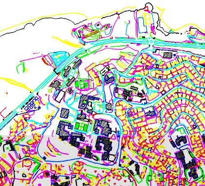
8 IKONOS panchromatic IKONOS pan-sharpened QuickBird panchromatic QuickBird pan-sharpened OrbView-3 panchromatic Turkish topographic map 1 : 5000 Figure 12: mapping with panchromatic and pan-sharpened space images


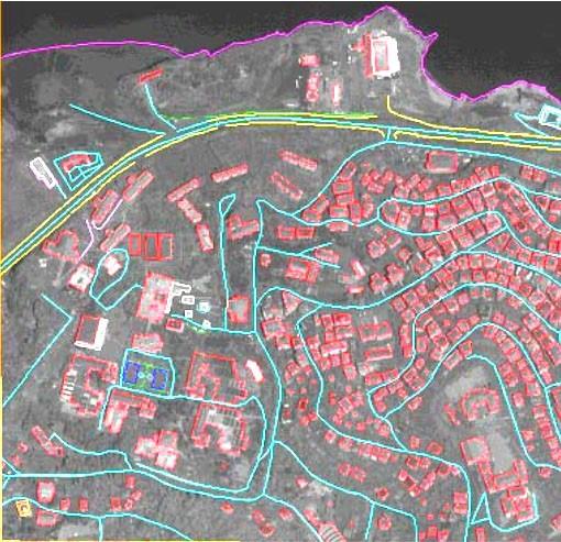
9 The influence of the GSD to the object identification is obvious in figure 13. With 2.5m GSD large and isolated buildings can be identified and mapped, smaller buildings in most cases can be identified, but mapped only with a symbol. Of course this is quite different for 0.5m GSD here any chimney and visible window can be seen. Cartosat-1 2.5m GSD WorldView-1 0.5m GSD Figure 13: influence of GSD to object recognition In figure 12 the result of on-screen digitizing of ortho-images is super-imposed to the ortho-images. Panchromatic and pan-sharpened IKONOS and QuickBird images and panchromatic OrbView-3 scenes have been vectorized. For medium and larger buildings with regular roof-shape, the mapping is easy with all images. Sometimes concrete roofs cannot be separated from the surrounding garden if no shadow is increasing the contrast. Even in the very high resolution QuickBird images sometimes the contrast of buildings is not sufficient for a precise mapping. The side-line of roads cannot be extracted since they are located in shadow or occluded by buildings and trees and not in any case there is a clear side line in nature like shown in the topographic map. In fact there is only a limited difference between mapping with panchromatic and pansharpened images. Especially few additional smaller buildings in unplanned areas (lower centre of maps in figure 12) have been mapped with pan-sharpened images. But the color is helpful for object interpretation and speeds up the data acquisition. The higher resolution of QuickBird allows the plot of few additional unpaved paths and shorter streets located in shadows or hidden by buildings in the IKONOS scene. The result based on IKONOS and OrbView-3 is not too different, only very few details have not been mapped with OrbView-3. As result of mapping also with other space images like SPOT-5, IRS-1C and KOMPSAT-2, the required GSD for the identification of average size objects, having average contrast, is shown in table 2. Because of the lower limit for the requirement of 2m, no major difference of mapping with IKONOS, OrbView-3 and QuickBird can be seen in the maps shown in figure 12. Nevertheless with QuickBird images more details of the buildings can be mapped. The EROS-B images have been used in a different area, so the comparison with the other very high resolution images is difficult, but the information contents is very close to QuickBird images. urban buildings foot path minor road network rail road fine hydrology major road network building blocks 4 CONCLUSION required GSD 2m 1-2m 5m 5m 5m 10m 10m Table 2: required GSD for object identification under usual conditions
10 Very high resolution space images can be used for the generation of large scale topographic maps also under the more difficult situation of urban areas. The geometric accuracy is not the limiting factor for the map scale; it is limited by the information contents of the images; that means the possibility of object identification. However, in relation to a topographic map 1 : 5000 not all objects could be mapped. This confirms the rule of thumb, that a GSD of at least 0.1mm in the map scale is required or reverse that IKONOS and OrbView-3 images can be used for the topographic map scale 1 : With the 0.6m GSD of QuickBird images more details can be seen like with 1m GSD, also the morphologic details are better, but the details of the reference map has not been reached. Of course this is also influenced by not so experienced operators and the extreme difficult test area, but also with aerial images not all details can be extracted and a field check is required. In not so mountainous terrain and in planned build up areas it is quite easier to generate topographic maps and QuickBird as well as WorldView-1 images can be used up to the map scale 1 : Also the EROS-B images are including a similar information contents if the striping is removed. The map scale 1 : 5000 is sufficient as base of a cadastre or a land consolidation as well as for urban planning. Not only the GSD; also the imaging conditions are important. The sun elevation plays a major role because mapping in the shadow may be quite difficult. A larger incidence angle may cause not acceptable occlusion in city areas. On the other hand a larger incidence angle gives an oblique view like used by Pictometry, this may be helpful for object interpretation especially by untrained staff. The colour is helpful for object identification, speeds up the mapping but does not lead to more details and higher accuracy. REFERENCES Jacobsen, K., Büyüksalih, G., 2006: Mapping from Space - a Cooperation of Zonguldak Karaelmas University and University of Hannover, 5th Turkish-German Geodetic Days, Berlin 2006, (access 4/2008) Jacobsen, K., 2007: Orientation of high resolution optical space images, ASPRS annual conference, Tampa 2007, on CD Topan, H., Büyüksalih, G.,Jacobsen, K., 2004: Comparison of Information Contents of High Resolution Space Images, ISPRS Congress, Istanbul 2004, IntArchPhRS. Vol XXXV, B4. pp Topan, H., Büyüksalih, G., Jacobsen, K., 2005: Information contents of High Resolution Satellite Images, EARSeL workshop 3D-remote sensing, Porto, 2005, on CD, + (access 4/2008)
COMPARISON OF INFORMATION CONTENTS OF HIGH RESOLUTION SPACE IMAGES
 COMPARISON OF INFORMATION CONTENTS OF HIGH RESOLUTION SPACE IMAGES H. Topan*, G. Büyüksalih*, K. Jacobsen ** * Karaelmas University Zonguldak, Turkey ** University of Hannover, Germany htopan@karaelmas.edu.tr,
CHARACTERISTICS OF VERY HIGH RESOLUTION OPTICAL SATELLITES FOR TOPOGRAPHIC MAPPING
 CHARACTERISTICS OF VERY HIGH RESOLUTION OPTICAL SATELLITES FOR TOPOGRAPHIC MAPPING K. Jacobsen Leibniz University Hannover, Institute of Photogrammetry and Geoinformation jacobsen@ipi.uni-hannover.de Commission
DEM GENERATION WITH WORLDVIEW-2 IMAGES
 DEM GENERATION WITH WORLDVIEW-2 IMAGES G. Büyüksalih a, I. Baz a, M. Alkan b, K. Jacobsen c a BIMTAS, Istanbul, Turkey - (gbuyuksalih, ibaz-imp)@yahoo.com b Zonguldak Karaelmas University, Zonguldak, Turkey
RADIOMETRIC AND GEOMETRIC CHARACTERISTICS OF PLEIADES IMAGES
 RADIOMETRIC AND GEOMETRIC CHARACTERISTICS OF PLEIADES IMAGES K. Jacobsen a, H. Topan b, A.Cam b, M. Özendi b, M. Oruc b a Leibniz University Hannover, Institute of Photogrammetry and Geoinformation, Germany;
INFORMATION CONTENT ANALYSIS FROM VERY HIGH RESOLUTION OPTICAL SPACE IMAGERY FOR UPDATING SPATIAL DATABASE
 INFORMATION CONTENT ANALYSIS FROM VERY HIGH RESOLUTION OPTICAL SPACE IMAGERY FOR UPDATING SPATIAL DATABASE M. Alkan a, * a Department of Geomatics, Faculty of Civil Engineering, Yıldız Technical University,
CALIBRATION OF OPTICAL SATELLITE SENSORS
 CALIBRATION OF OPTICAL SATELLITE SENSORS KARSTEN JACOBSEN University of Hannover Institute of Photogrammetry and Geoinformation Nienburger Str. 1, D-30167 Hannover, Germany jacobsen@ipi.uni-hannover.de
Geometric potential of Pleiades models with small base length
 European Remote Sensing: Progress, Challenges and Opportunities EARSeL, 2015 Geometric potential of Pleiades models with small base length Karsten Jacobsen Leibniz University Hannover, Institute of Photogrammetry
POTENTIAL OF MANUAL AND AUTOMATIC FEATURE EXTRACTION FROM HIGH RESOLUTION SPACE IMAGES IN MOUNTAINOUS URBAN AREAS
 POTENTIAL OF MANUAL AND AUTOMATIC FEATURE EXTRACTION FROM HIGH RESOLUTION SPACE IMAGES IN MOUNTAINOUS URBAN AREAS H. Topan a, *, M. Oruç a, K. Jacobsen b a ZKU, Engineering Faculty, Dept. of Geodesy and
CALIBRATION OF IMAGING SATELLITE SENSORS
 CALIBRATION OF IMAGING SATELLITE SENSORS Jacobsen, K. Institute of Photogrammetry and GeoInformation, University of Hannover jacobsen@ipi.uni-hannover.de KEY WORDS: imaging satellites, geometry, calibration
DEMS BASED ON SPACE IMAGES VERSUS SRTM HEIGHT MODELS. Karsten Jacobsen. University of Hannover, Germany
 DEMS BASED ON SPACE IMAGES VERSUS SRTM HEIGHT MODELS Karsten Jacobsen University of Hannover, Germany jacobsen@ipi.uni-hannover.de Key words: DEM, space images, SRTM InSAR, quality assessment ABSTRACT
Airborne or Spaceborne Images for Topographic Mapping?
 Advances in Geosciences Konstantinos Perakis, Editor EARSeL, 2012 Airborne or Spaceborne Images for Topographic Mapping? Karsten Jacobsen Leibniz University Hannover, Institute of Photogrammetry and Geoinformation,
EXAMPLES OF TOPOGRAPHIC MAPS PRODUCED FROM SPACE AND ACHIEVED ACCURACY CARAVAN Workshop on Mapping from Space, Phnom Penh, June 2000
 EXAMPLES OF TOPOGRAPHIC MAPS PRODUCED FROM SPACE AND ACHIEVED ACCURACY CARAVAN Workshop on Mapping from Space, Phnom Penh, June 2000 Jacobsen, Karsten University of Hannover Email: karsten@ipi.uni-hannover.de
High Resolution Sensor Test Comparison with SPOT, KFA1000, KVR1000, IRS-1C and DPA in Lower Saxony
 High Resolution Sensor Test Comparison with SPOT, KFA1000, KVR1000, IRS-1C and DPA in Lower Saxony K. Jacobsen, G. Konecny, H. Wegmann Abstract The Institute for Photogrammetry and Engineering Surveys
HIGH RESOLUTION IMAGERY FOR MAPPING AND LANDSCAPE MONITORING
 HIGH RESOLUTION IMAGERY FOR MAPPING AND LANDSCAPE MONITORING Karsten Jacobsen Leibniz University Hannover, Institute of Photogrammetry and Geoinformation Nienburger Str. 1, 30165 Hannover, Germany, jacobsen@ipi.uni-hannover.de
TELLS THE NUMBER OF PIXELS THE TRUTH? EFFECTIVE RESOLUTION OF LARGE SIZE DIGITAL FRAME CAMERAS
 TELLS THE NUMBER OF PIXELS THE TRUTH? EFFECTIVE RESOLUTION OF LARGE SIZE DIGITAL FRAME CAMERAS Karsten Jacobsen Leibniz University Hannover Nienburger Str. 1 D-30167 Hannover, Germany jacobsen@ipi.uni-hannover.de
ANALYSIS OF SRTM HEIGHT MODELS
 ANALYSIS OF SRTM HEIGHT MODELS Sefercik, U. *, Jacobsen, K.** * Karaelmas University, Zonguldak, Turkey, ugsefercik@hotmail.com **Institute of Photogrammetry and GeoInformation, University of Hannover,
ROLE OF SATELLITE DATA APPLICATION IN CADASTRAL MAP AND DIGITIZATION OF LAND RECORDS DR.T. RAVISANKAR GROUP HEAD (LRUMG) RSAA/NRSC/ISRO /DOS HYDERABAD
 RSAA/NRSC/ISRO /DOS HYDERABAD") ROLE OF SATELLITE DATA APPLICATION IN CADASTRAL MAP AND DIGITIZATION OF LAND RECORDS DR.T. RAVISANKAR GROUP HEAD (LRUMG) RSAA/NRSC/ISRO /DOS HYDERABAD WORKSHOP on Best Practices under National Land Records
ROLE OF SATELLITE DATA APPLICATION IN CADASTRAL MAP AND DIGITIZATION OF LAND RECORDS DR.T. RAVISANKAR GROUP HEAD (LRUMG) RSAA/NRSC/ISRO /DOS HYDERABAD WORKSHOP on Best Practices under National Land Records
Tutorial 10 Information extraction from high resolution optical satellite sensors
 Tutorial 10 Information extraction from high resolution optical satellite sensors Karsten Jacobsen 1, Emmanuel Baltsavias 2, David Holland 3 1 University of, ienburger Strasse 1, D-30167, Germany, jacobsen@ipi.uni-hannover.de
Section 2 Image quality, radiometric analysis, preprocessing
 Section 2 Image quality, radiometric analysis, preprocessing Emmanuel Baltsavias Radiometric Quality (refers mostly to Ikonos) Preprocessing by Space Imaging (similar by other firms too): Modulation Transfer
RECENT DEVELOPMENTS OF DIGITAL CAMERAS AND SPACE IMAGERY. Karsten JACOBSEN
 RECENT DEVELOPMENTS OF DIGITAL CAMERAS AND SPACE IMAGERY Abstract Karsten JACOBSEN Leibniz University Hannover, Institute of Photogrammetry and Geoinformation, Nienburger Str. 1, D-30167 Hannover, Germany
PROPERTY OF THE LARGE FORMAT DIGITAL AERIAL CAMERA DMC II
 PROPERTY OF THE LARGE FORMAT DIGITAL AERIAL CAMERA II K. Jacobsen a, K. Neumann b a Institute of Photogrammetry and GeoInformation, Leibniz University Hannover, Germany jacobsen@ipi.uni-hannover.de b Z/I
EVALUATION OF PLEIADES-1A TRIPLET ON TRENTO TESTFIELD
 EVALUATION OF PLEIADES-1A TRIPLET ON TRENTO TESTFIELD D. Poli a, F. Remondino b, E. Angiuli c, G. Agugiaro b a Terra Messflug GmbH, Austria b 3D Optical Metrology Unit, Fondazione Bruno Kessler, Trento,
Abstract Quickbird Vs Aerial photos in identifying man-made objects
 Abstract Quickbird Vs Aerial s in identifying man-made objects Abdullah Mah abdullah.mah@aramco.com Remote Sensing Group, emap Division Integrated Solutions Services Department (ISSD) Saudi Aramco, Dhahran
High Resolution Imaging Satellite Systems
 High Resolution Imaging Satellite Systems K. Jacobsen University of Hannover, Germany Keywords: high resolution space sensors, SAR ABSTRACT: The number of existing and announced high and very high resolution
POTENTIAL OF LARGE FORMAT DIGITAL AERIAL CAMERAS. Dr. Karsten Jacobsen Leibniz University Hannover, Germany
 POTENTIAL OF LARGE FORMAT DIGITAL AERIAL CAMERAS Dr. Karsten Jacobsen Leibniz University Hannover, Germany jacobsen@ipi.uni-hannover.de Introduction: Digital aerial cameras are replacing traditional analogue
With the higher resolution
 Visualisation High resolution satellite imaging systems an overview by Dr.-Ing Karsten Jacobsen, Hannover University, Germany More and more high and very high resolution optical space sensors are becoming
HIGH RESOLUTION COLOR IMAGERY FOR ORTHOMAPS AND REMOTE SENSING. Author: Peter Fricker Director Product Management Image Sensors
 HIGH RESOLUTION COLOR IMAGERY FOR ORTHOMAPS AND REMOTE SENSING Author: Peter Fricker Director Product Management Image Sensors Co-Author: Tauno Saks Product Manager Airborne Data Acquisition Leica Geosystems
An Introduction to Geomatics. Prepared by: Dr. Maher A. El-Hallaq خاص بطلبة مساق مقدمة في علم. Associate Professor of Surveying IUG
 An Introduction to Geomatics خاص بطلبة مساق مقدمة في علم الجيوماتكس Prepared by: Dr. Maher A. El-Hallaq Associate Professor of Surveying IUG 1 Airborne Imagery Dr. Maher A. El-Hallaq Associate Professor
Tutorial 10 Information extraction from high resolution optical satellite sensors
 Tutorial 10 Information extraction from high resolution optical satellite sensors Karsten Jacobsen 1, Emmanuel Baltsavias 2, David Holland 3 1 University of, Nienburger Strasse 1, D-30167, Germany, jacobsen@ipi.uni-hannover.de
FEDERAL SPACE AGENCY SOVZOND JSC компания «Совзонд»
 FEDERAL SPACE AGENCY Resurs-DK.satellite SOVZOND JSC SPECIFICATIONS Launch date June 15, 2006 Carrier vehicle Soyuz Orbit Elliptical Altitude 360-604 km Revisit frequency (at nadir) 6 days Inclination
TEMPORAL ANALYSIS OF MULTI EPOCH LANDSAT GEOCOVER IMAGES IN ZONGULDAK TESTFIELD
 TEMPORAL ANALYSIS OF MULTI EPOCH LANDSAT GEOCOVER IMAGES IN ZONGULDAK TESTFIELD Şahin, H. a*, Oruç, M. a, Büyüksalih, G. a a Zonguldak Karaelmas University, Zonguldak, Turkey - (sahin@karaelmas.edu.tr,
Leica ADS80 - Digital Airborne Imaging Solution NAIP, Salt Lake City 4 December 2008
 Luzern, Switzerland, acquired at 5 cm GSD, 2008. Leica ADS80 - Digital Airborne Imaging Solution NAIP, Salt Lake City 4 December 2008 Shawn Slade, Doug Flint and Ruedi Wagner Leica Geosystems AG, Airborne
Automated GIS data collection and update
 Walter 267 Automated GIS data collection and update VOLKER WALTER, S tuttgart ABSTRACT This paper examines data from different sensors regarding their potential for an automatic change detection approach.
Int n r t o r d o u d c u ti t on o n to t o Remote Sensing
 Introduction to Remote Sensing Definition of Remote Sensing Remote sensing refers to the activities of recording/observing/perceiving(sensing)objects or events at far away (remote) places. In remote sensing,
Remote Sensing Platforms
 Types of Platforms Lighter-than-air Remote Sensing Platforms Free floating balloons Restricted by atmospheric conditions Used to acquire meteorological/atmospheric data Blimps/dirigibles Major role - news
CHARACTERISTICS OF REMOTELY SENSED IMAGERY. Spatial Resolution
 CHARACTERISTICS OF REMOTELY SENSED IMAGERY Spatial Resolution There are a number of ways in which images can differ. One set of important differences relate to the various resolutions that images express.
TechTime New Mapping Tools for Transportation Engineering
 GeoEye-1 Stereo Satellite Imagery Presented by Karl Kliparchuk, M.Sc., GISP kkliparchuk@mcelhanney.com 604-683-8521 All satellite imagery are copyright GeoEye Corp GeoEye-1 About GeoEye Corp Headquarters:
High Resolution Satellite Data for Forest Management. - Algorithm for Tree Counting -
 High Resolution Satellite Data for Forest Management - Algorithm for Tree Counting - Kiyoshi HONDA ACRoRS, Asian Institute of Technology NASDA ALOS (NASDA JAPAN) 2.5m Resolution Launch in 2002 Panchromatic
Aerial photography: Principles. Frame capture sensors: Analog film and digital cameras
 Aerial photography: Principles Frame capture sensors: Analog film and digital cameras Overview Introduction Frame vs scanning sensors Cameras (film and digital) Photogrammetry Orthophotos Air photos are
Satellite Imagery Characteristics, Uses and Delivery to GIS Systems. Wayne Middleton April 2014
 Satellite Imagery Characteristics, Uses and Delivery to GIS Systems Wayne Middleton April 2014 About Geoimage Founded in Brisbane 1988 Leading Independent company Specialists in satellite imagery and geospatial
Image Fusion. Pan Sharpening. Pan Sharpening. Pan Sharpening: ENVI. Multi-spectral and PAN. Magsud Mehdiyev Geoinfomatics Center, AIT
 1 Image Fusion Sensor Merging Magsud Mehdiyev Geoinfomatics Center, AIT Image Fusion is a combination of two or more different images to form a new image by using certain algorithms. ( Pohl et al 1998)
ENVI Orthorectification Module
 Visual Information Solutions ENVI Orthorectification Module Orthorectify Your Imagery Quickly and Easily. Rigorous Orthorectification. Simple Workflow. Trusted Method. The Need for Orthorectification Satellite
HIGH RESOLUTION SATELLITE IMAGING SYSTEMS - OVERVIEW
 HIGH RESOLUTION SATELLITE IMAGING SYSTEMS - OVERVIEW K. Jacobsen University of Hannover jacobsen@ipi.uni-hannover.de KEY WORDS: Satellite, optical sensors, SAR ABSTRACT: More and more high and very high
POTENTIAL OF HIGH-RESOLUTION INDIAN REMOTE SENSING SATELLITE IMAGERY FOR LARGE SCALE MAPPING
 POTENTIAL OF HIGH-RESOLUTION INDIAN REMOTE SENSING SATELLITE IMAGERY FOR LARGE SCALE MAPPING P.V. Radhadevi *, V.Nagasubramanian, Archana Mahapatra, S.S.Solanki, Krishna Sumanth & Geeta Varadan Advanced
News on Image Acquisition for Campaign 2008
 Ispra, 3-4/04/2008 CwRS KO meeting 1 News on Image Acquisition for Campaign 2008 Pär Johan Åstrand, Maria Erlandsson, annian Zhu CID Action Ispra, 3-4/04/2008 CwRS KO meeting 2 Outline of presentation
The Most Suitable Sizes Of Ground Control Points (Gcps) For World View2
 For World View2") The Most Suitable Sizes Of Ground Control Points (Gcps) For World View2 Dr. O. Mutluoglu Dr.M. Yakar Dr. H.M. Yilmaz 1 INTRODUCTION High resolution satellite images, (less than 1 m. Resolution) are used
The Most Suitable Sizes Of Ground Control Points (Gcps) For World View2 Dr. O. Mutluoglu Dr.M. Yakar Dr. H.M. Yilmaz 1 INTRODUCTION High resolution satellite images, (less than 1 m. Resolution) are used
LPIS Orthoimagery An assessment of the Bing imagery for LPIS purpose
 LPIS Orthoimagery An assessment of the Bing imagery for LPIS purpose Slavko Lemajić Wim Devos, Pavel Milenov GeoCAP Action - MARS Unit - JRC Ispra Tallinn, 24 th November 2011 Outline JRC`s Ortho specifications
Satellite Ortho Suite
 Technical Specifications Satellite Ortho Suite The Satellite Ortho Suite includes rigorous and rational function models developed to compensate for distortions and produce orthorectified satellite images
Fusion of Heterogeneous Multisensor Data
 Fusion of Heterogeneous Multisensor Data Karsten Schulz, Antje Thiele, Ulrich Thoennessen and Erich Cadario Research Institute for Optronics and Pattern Recognition Gutleuthausstrasse 1 D 76275 Ettlingen
ENVI Orthorectification Module
 ENVI Orthorectification Module Orthorectify your imagery quickly and easily. CREASO - your partner for visual information solutions Rigorous Orthorectification. Simple Workflow. Trusted Method. The Need
New remote sensing sensors and imaging products for the monitoring of urban dynamics
 Geoinformation for European-wide Integration, Benes (ed.) 2003 Millpress, Rotterdam, ISBN 90-77017-71-2 New remote sensing sensors and imaging products for the monitoring of urban dynamics Matthias Möller
REMOTE SENSING INTERPRETATION
 REMOTE SENSING INTERPRETATION Jan Clevers Centre for Geo-Information - WU Remote Sensing --> RS Sensor at a distance EARTH OBSERVATION EM energy Earth RS is a tool; one of the sources of information! 1
Planet Labs Inc 2017 Page 2
 SKYSAT IMAGERY PRODUCT SPECIFICATION: ORTHO SCENE LAST UPDATED JUNE 2017 SALES@PLANET.COM PLANET.COM Disclaimer This document is designed as a general guideline for customers interested in acquiring Planet
remote sensing? What are the remote sensing principles behind these Definition
 Introduction to remote sensing: Content (1/2) Definition: photogrammetry and remote sensing (PRS) Radiation sources: solar radiation (passive optical RS) earth emission (passive microwave or thermal infrared
UNOSAT Satellite Imagery and GIS Solutions for DRR and Emergency Management
 UNOSAT Satellite Imagery and GIS Solutions for DRR and Emergency Management Francesco Pisano Director, Research, Technology Applications & Knowledge Systems January 2013 Introduction to UNOSAT 2 About
Summary of the VHR image acquisition Campaign 2014 and new sensors for 2015
 Summary of the VHR image acquisition Campaign 2014 and new sensors for 2015 Michaela Neumann, George Ellis, Samuel Bärisch, Blanka Vajsova 19 November 2014, Dresden 20th MARS Conference Presentation Outline
Advanced Techniques in Urban Remote Sensing
 Advanced Techniques in Urban Remote Sensing Manfred Ehlers Institute for Geoinformatics and Remote Sensing (IGF) University of Osnabrueck, Germany mehlers@igf.uni-osnabrueck.de Contents Urban Remote Sensing:
COMPARISON OF HIGH RESOLUTION MAPPING FROM SPACE
 COMPARISON OF HIGH RESOLUTION MAPPING FROM SPACE Karsten Jacobsen Institute for Photogrammetry and GeoInformation University of Hannover Nienburger Str. 1 D-30167 Hannover Germany jacobsen@ipi.uni-hannover.de
INFORMATION CONTENT ANALYSIS OF KVR-1000 ORTHO-IMAGE BASED ON THE AVAILABLE TOPOGRAPHIC MAPS IN THE GIS ENVIRONMENT
 EARSEL Workshop on Remote Sensing for Developing Countries, Cairo, 2004 1 INFORMATION CONTENT ANALYSIS OF KVR-1000 ORTHO-IMAGE BASED ON THE AVAILABLE TOPOGRAPHIC MAPS IN THE GIS ENVIRONMENT H. Sahin, G.
Geomatica OrthoEngine v10.2 Tutorial Orthorectifying ALOS PRISM Data Rigorous and RPC Modeling
 Geomatica OrthoEngine v10.2 Tutorial Orthorectifying ALOS PRISM Data Rigorous and RPC Modeling ALOS stands for Advanced Land Observing Satellite and was developed by the Japan Aerospace Exploration Agency
Image interpretation I and II
 Image interpretation I and II Looking at satellite image, identifying different objects, according to scale and associated information and to communicate this information to others is what we call as IMAGE
9/12/2011. Training Course Remote Sensing Basic Theory & Image Processing Methods September 2011
 Training Course Remote Sensing Basic Theory & Image Processing Methods 19 23 September 2011 Popular Remote Sensing Sensors & their Selection Michiel Damen (September 2011) damen@itc.nl 1 Overview Low resolution
Remote sensing in archaeology from optical to lidar. Krištof Oštir ModeLTER Scientific Research Centre of the Slovenian Academy of Sciences and Arts
 Remote sensing in archaeology from optical to lidar Krištof Oštir ModeLTER Scientific Research Centre of the Slovenian Academy of Sciences and Arts Introduction Optical remote sensing Systems Search for
Remote Sensing Platforms
 Remote Sensing Platforms Remote Sensing Platforms - Introduction Allow observer and/or sensor to be above the target/phenomena of interest Two primary categories Aircraft Spacecraft Each type offers different
Geomatica OrthoEngine Orthorectifying SPOT6 data
 Geomatica OrthoEngine Orthorectifying SPOT6 data On September 9, 2012, SPOT 6 was launched adding to the constellation of Earthimaging satellites designed to provide 1.5m high-resolution data. The architecture
9/12/2011. Training Course Remote Sensing Basic Theory & Image Processing Methods September 2011
 Training Course Remote Sensing Basic Theory & Image Processing Methods 19 23 September 2011 Remote Sensing Platforms Michiel Damen (September 2011) damen@itc.nl 1 Overview Platforms & missions aerial surveys
School of Rural and Surveying Engineering National Technical University of Athens
 Laboratory of Photogrammetry National Technical University of Athens Combined use of spaceborne optical and SAR data Incompatible data sources or a useful procedure? Charalabos Ioannidis, Dimitra Vassilaki
How to get base geospatial data for SDI from high resolution satellite images
 How to get base geospatial data for SDI from high resolution satellite images E. Baltsavias with contributions from Zhang Li, Henri Eisenbeiss, Maria Pateraki, Daniela Poli, Chunsun Zhang, Fabio Remondino,
TESTFIELD TRENTO: GEOMETRIC EVALUATION OF VERY HIGH RESOLUTION SATELLITE IMAGERY
 TESTFIELD TRENTO: GEOMETRIC EVALUATION OF VERY HIGH RESOLUTION SATELLITE IMAGERY G. AGUGIAROa, D. POLIb, F. REMONDINOa, 3DOM, 3D Optical Metrology Unit Bruno Kessler Foundation, Trento, Italy a b Vermessung
Geometry of Aerial Photographs
 Geometry of Aerial Photographs Aerial Cameras Aerial cameras must be (details in lectures): Geometrically stable Have fast and efficient shutters Have high geometric and optical quality lenses They can
Files Used in This Tutorial. Background. Calibrating Images Tutorial
 In this tutorial, you will calibrate a QuickBird Level-1 image to spectral radiance and reflectance while learning about the various metadata fields that ENVI uses to perform calibration. This tutorial
Volume 1 - Module 6 Geometry of Aerial Photography. I. Classification of Photographs. Vertical
 RSCC Volume 1 Introduction to Photo Interpretation and Photogrammetry Table of Contents Module 1 Module 2 Module 3.1 Module 3.2 Module 4 Module 5 Module 6 Module 7 Module 8 Labs Volume 1 - Module 6 Geometry
WorldView-2. WorldView-2 Overview
 WorldView-2 WorldView-2 Overview 6/4/09 DigitalGlobe Proprietary 1 Most Advanced Satellite Constellation Finest available resolution showing crisp detail Greatest collection capacity Highest geolocation
Introduction to KOMPSAT
 Introduction to KOMPSAT September, 2016 1 CONTENTS 01 Introduction of SIIS 02 KOMPSAT Constellation 03 New : KOMPSAT-3 50 cm 04 New : KOMPSAT-3A 2 KOMPSAT Constellation KOMPSAT series National space program
EO Data Today and Application Fields. Denise Petala
 EO Data Today and Application Fields Denise Petala ! IGD GROUP AE "Infotop SA, Geomet Ltd., Dynatools Ltd. "Equipment and know how in many application fields, from surveying till EO data and RS. # Leica,
ERDAS IMAGINE Suite Comparison
 ERDAS Suite Comparison A brief comparison of Essentials, Advantage and Professional age 1 of 7 Overview This document provides a brief comparison of the main features and capabilities found within the
Govt. Engineering College Jhalawar Model Question Paper Subject- Remote Sensing & GIS
 Govt. Engineering College Jhalawar Model Question Paper Subject- Remote Sensing & GIS Time: Max. Marks: Q1. What is remote Sensing? Explain the basic components of a Remote Sensing system. Q2. What is
Data Sharing Issues in SE Asia
 Data Sharing Issues in SE Asia Kandasri Limpakom User Service and Business Development Office About GISTDA THEOS & Its Applications GISTDA s Data Sharing Geo-Informatics and Space Technology Development
News on Image Acquisition for the CwRS Campaign new sensors and changes
 Control Methods Workshop: 6-8 / 4 / 2009 [CwRS KO Meeting Campaign 2009] 1 News on Image Acquisition for the CwRS Campaign 2009 - new sensors and changes Pär Johan Åstrand, Joanna Nowak, Maria Erlandsson
INTEGRATED DEM AND PAN-SHARPENED SPOT-4 IMAGE IN URBAN STUDIES
 INTEGRATED DEM AND PAN-SHARPENED SPOT-4 IMAGE IN URBAN STUDIES G. Doxani, A. Stamou Dept. Cadastre, Photogrammetry and Cartography, Aristotle University of Thessaloniki, GREECE gdoxani@hotmail.com, katerinoudi@hotmail.com
GIS Data Collection. Remote Sensing
 GIS Data Collection Remote Sensing Data Collection Remote sensing Introduction Concepts Spectral signatures Resolutions: spectral, spatial, temporal Digital image processing (classification) Other systems
Image interpretation. Aliens create Indian Head with an ipod? Badlands Guardian (CBC) This feature can be found 300 KMs SE of Calgary.
 This feature can be found 300 KMs SE of Calgary.") Image interpretation Aliens create Indian Head with an ipod? Badlands Guardian (CBC) This feature can be found 300 KMs SE of Calgary. 50 1 N 110 7 W Milestones in the History of Remote Sensing 19 th century
Image interpretation Aliens create Indian Head with an ipod? Badlands Guardian (CBC) This feature can be found 300 KMs SE of Calgary. 50 1 N 110 7 W Milestones in the History of Remote Sensing 19 th century
UltraCam and UltraMap Towards All in One Solution by Photogrammetry
 Photogrammetric Week '11 Dieter Fritsch (Ed.) Wichmann/VDE Verlag, Belin & Offenbach, 2011 Wiechert, Gruber 33 UltraCam and UltraMap Towards All in One Solution by Photogrammetry ALEXANDER WIECHERT, MICHAEL
Leica - 3 rd Generation Airborne Digital Sensors Features / Benefits for Remote Sensing & Environmental Applications
 Leica - 3 rd Generation Airborne Digital Sensors Features / Benefits for Remote Sensing & Environmental Applications Arthur Rohrbach, Sensor Sales Dir Europe, Middle-East and Africa (EMEA) Luzern, Switzerland,
KOMPSAT Constellation. November 2012 Satrec Initiative
 KOMPSAT Constellation November 2012 Satrec Initiative KOMPSAT Constellation KOMPSAT National program Developed and operated by KARI (Korea Aerospace Research Institute) Dual use : Government & commercial
Atmospheric Correction (including ATCOR)
") Technical Specifications Atmospheric Correction (including ATCOR) The data obtained by optical satellite sensors with high spatial resolution has become an invaluable tool for many groups interested in
Technical Specifications Atmospheric Correction (including ATCOR) The data obtained by optical satellite sensors with high spatial resolution has become an invaluable tool for many groups interested in
DIGITALGLOBE SATELLITE IMAGERY AND CLOUD SERVICES FOR SUGARCANE MAPPING
 DIGITALGLOBE SATELLITE IMAGERY AND CLOUD SERVICES FOR SUGARCANE MAPPING PRESENTER: DILLON PANIZZOLO (TECHNICAL MANAGER) COMPANY: GEO DATA DESIGN DATE: 18 TH AUGUST 2015 SASTA Congress Sugar Cane Mapping
Introduction to WG5 on CwRS imagery use and alternatives and QE5 on claimed rate inside the RP Peter Viskum Jørgensen, FERV and Birger Faurholt
 Introduction to WG5 on CwRS imagery use and alternatives and QE5 on claimed rate inside the RP Peter Viskum Jørgensen, FERV and Birger Faurholt Pedersen, University of Aarhus, DK CwRS Imagery use and alternatives
GEO 428: DEMs from GPS, Imagery, & Lidar Tuesday, September 11
 GEO 428: DEMs from GPS, Imagery, & Lidar Tuesday, September 11 Global Positioning Systems GPS is a technology that provides Location coordinates Elevation For any location with a decent view of the sky
LECTURE NOTES 2016 CONTENTS. Sensors and Platforms for Acquisition of Aerial and Satellite Image Data
 LECTURE NOTES 2016 Prof. John TRINDER School of Civil and Environmental Engineering Telephone: (02) 9 385 5020 Fax: (02) 9 313 7493 j.trinder@unsw.edu.au CONTENTS Chapter 1 Chapter 2 Sensors and Platforms
Sample Copy. Not For Distribution.
 Photogrammetry, GIS & Remote Sensing Quick Reference Book i EDUCREATION PUBLISHING Shubham Vihar, Mangla, Bilaspur, Chhattisgarh - 495001 Website: www.educreation.in Copyright, 2017, S.S. Manugula, V.
COMPARISON OF DIGITAL ELEVATION MODELS GENERATED FROM SPOT-5 HRS STEREO DATA AND CARTOSAT-1 STEREO DATA
 COMPARISON OF DIGITAL ELEVATION MODELS GENERATED FROM SPOT-5 HRS STEREO DATA AND CARTOSAT-1 STEREO DATA P V Radhadevi 1, Karsten Jacobsen 2,V Nagasubramanian 3, MV Jyothi 4 1,3, 4 Advanced Data processing
1. Introduction 2. Tectonics of NE Iceland Krafla rifting crisis (constraints from spy image matching)
") 1. Introduction 2. Tectonics of NE Iceland 3. 1975-1984 Krafla rifting crisis (constraints from spy image matching) 4. 1975-1984 Krafla rifting crisis (constraints from aerial photos) 5. Conclusions Tuesday
1. Introduction 2. Tectonics of NE Iceland 3. 1975-1984 Krafla rifting crisis (constraints from spy image matching) 4. 1975-1984 Krafla rifting crisis (constraints from aerial photos) 5. Conclusions Tuesday
OVERVIEW OF KOMPSAT-3A CALIBRATION AND VALIDATION
 OVERVIEW OF KOMPSAT-3A CALIBRATION AND VALIDATION DooChun Seo 1, GiByeong Hong 1, ChungGil Jin 1, DaeSoon Park 1, SukWon Ji 1 and DongHan Lee 1 1 KARI(Korea Aerospace Space Institute), 45, Eoeun-dong,
GEOMETRIC RECTIFICATION OF EUROPEAN HISTORICAL ARCHIVES OF LANDSAT 1-3 MSS IMAGERY
 GEOMETRIC RECTIFICATION OF EUROPEAN HISTORICAL ARCHIVES OF LANDSAT -3 MSS IMAGERY Torbjörn Westin Satellus AB P.O.Box 427, SE-74 Solna, Sweden tw@ssc.se KEYWORDS: Landsat, MSS, rectification, orbital model
Blacksburg, VA July 24 th 30 th, 2010 Remote Sensing Page 1. A condensed overview. For our purposes
 A condensed overview George McLeod Prepared by: With support from: NSF DUE-0903270 in partnership with: Geospatial Technician Education Through Virginia s Community Colleges (GTEVCC) The art and science
PLANET IMAGERY PRODUCT SPECIFICATIONS PLANET.COM
 PLANET IMAGERY PRODUCT SPECIFICATIONS SUPPORT@PLANET.COM PLANET.COM LAST UPDATED JANUARY 2018 TABLE OF CONTENTS LIST OF FIGURES 3 LIST OF TABLES 4 GLOSSARY 5 1. OVERVIEW OF DOCUMENT 7 1.1 Company Overview
ILLUMINATION CORRECTION OF LANDSAT TM DATA IN SOUTH EAST NSW
 ILLUMINATION CORRECTION OF LANDSAT TM DATA IN SOUTH EAST NSW Elizabeth Roslyn McDonald 1, Xiaoliang Wu 2, Peter Caccetta 2 and Norm Campbell 2 1 Environmental Resources Information Network (ERIN), Department
European Space Imaging
 European Space Imaging Use cases of Very High Resolution satellite imagery in support of crop management GEO-CRADLE Regional Workshop, 7/12/2017, Tunis Arnaud Durand adurand@euspaceimaging.com COMPANY
NON-PHOTOGRAPHIC SYSTEMS: Multispectral Scanners Medium and coarse resolution sensor comparisons: Landsat, SPOT, AVHRR and MODIS
 NON-PHOTOGRAPHIC SYSTEMS: Multispectral Scanners Medium and coarse resolution sensor comparisons: Landsat, SPOT, AVHRR and MODIS CLASSIFICATION OF NONPHOTOGRAPHIC REMOTE SENSORS PASSIVE ACTIVE DIGITAL