Summary of the VHR image acquisition Campaign 2014 and new sensors for 2015
|
|
|
- Loren Caitlin Parsons
- 5 years ago
- Views:
Transcription


 2014 VHR")

1 Summary of the VHR image acquisition Campaign 2014 and new sensors for 2015 Michaela Neumann, George Ellis, Samuel Bärisch, Blanka Vajsova 19 November 2014, Dresden 20th MARS Conference Presentation Outline VHR Satellite Imagery for CAP Checks (1) Contractual & Overview (2) 2014 VHR Campaign Statistics (3) New Sensors: WorldView-3 and KOMPSAT-3 Benchmarking 1
")
 In partnership with")

2 Contractual & Overview 2014: First Year of Outsourcing Michaela Neumann, European Space Imaging Contractual & Overview VHR Profile Provider Involved in CwRS since 2003 European Space Imaging (EUSI) awarded multi-year ( ) contract for Supply of satellite remote sensing imagery and associated services in support to checks within the Common Agricultural Policy (VHR Profile) In partnership with GAF AG and German Aerospace Center (DLR) and supported by DigitalGlobe, e- GEOS, SI Imaging Services, Imagesat International VHR satellites available in 2014: WorldView-1, WorldView-2, GeoEye-1, QuickBird+ IKONOS, EROS B 2
 Source and Ortho data provision/return to JRC Improvements of VHR specifications NG-Lio development & maintenance (see presentation & demo) Benchmarking of new")

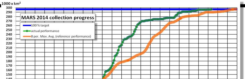
3 Contractual & Overview Supply of VHR imagery & related services Communication with the MS and its contractors (feasibility iterations; image acquisition & delivery; ortho return) Susanne Hain Ordering and Invoicing (EUSI-JRC) Source and Ortho data provision/return to JRC Improvements of VHR specifications NG-Lio development & maintenance (see presentation & demo) Benchmarking of new sensors (KOMPSAT-3 and WorldView-3) Agnieszka Walczynska Edith Simon Michael Bischofer Campaign Overview % 99% 100% 99% 99% 97% 94% Evolution of the VHR Campaign % 100% 100% 100% % 90% 80% Area size in km² % % % % 3

4 2014 VHR Campaign Statistics George Ellis, European Space Imaging 4

5 VHR Profiles A1. VHR prime CwRS A2. VHR prime - LPIS/Hilly/Complex A4. VHR Stereo B. VHR Archive C. VHR re-task Zones with 2nd VHR window 561 Zones in 29 countries VHR - Numbers Planned/Purchased No. of zones Area [km 2 ] total % 299, % PROFILES A1. VHR prime CwRS % 213, % A2. VHR prime - LPIS/Hilly/Complex % 82, % A4. VHR - Stereo 1 0.2% % B. VHR archive 3 0.5% 2, % D. VHR re-task 2 0.4% % 5
![VHR more Numbers No. of zones % Area[km2] % total 561 100 % 299,415 100 % VHR-1 516 92% 272,605 91% VHR-2 42 7.5% 24,169 8.1 % Archive 3 0.5% 241 0.](/docs-images/95/124803605/images/6-0.jpg "9% VHR backup planned 53 43,239 Failed 0 0 Number of 780 100% accepted uploads Validated 775 99.4% Proposed 5 0.6% Haze free 712 91.3% Haze flagged 68 8.")
6 VHR more Numbers No. of zones % Area[km2] % total % 299, % VHR % 272,605 91% VHR % 24, % Archive 3 0.5% % VHR backup planned 53 43,239 Failed 0 0 Number of % accepted uploads Validated % Proposed 5 0.6% Haze free % Haze flagged % Back-up not used VHR Distribution of Area per Sensor Sensor Area [km 2 ] % No. of uploads WV02 185,800 62% 469 GE01 95,798 32% 247 QB 17,817 6% 64 Total area (CwRS+LPIS) 299, % 780 6
![VHR Distribution of Area per Sensor Year 2010* 2011* 2012* 2013** 2014 Average window length [days] 58 64 61 60 65 Average area [sqkm] /zone 640 555 516 510 534 Average acquisition time 31 14 17 18](/docs-images/95/124803605/images/7-0.jpg "17 Average time delay between first and last acquisition [days] ~18 ~13 ~11 ~16 ~4 Number of extended windows 46 13 0 20 7*** Number of re-tasked zones 8 10 0 4 2 (227sqkm) Successrate [area] 100%")
7 VHR Distribution of Area per Sensor Year 2010* 2011* 2012* 2013** 2014 Average window length [days] Average area [sqkm] /zone Average acquisition time Average time delay between first and last acquisition [days] ~18 ~13 ~11 ~16 ~4 Number of extended windows *** Number of re-tasked zones (227sqkm) Successrate [area] 100% 99%* *Gervasini, E., Vajsova, B., Aspinall, C., San-Miguel, I., Breunig, J., Gentilini, S., Åstrand, P., Summary Report of 2012 CwRS Image Acquisition Campaign **San-Miguel, I., Wirnhardt, C., Breunig, J., Åstrand, P., Vajsova, B., 2013 Image acquisition campaign. 19th Annual MARS Conference *** plus 1 zone extended but actually completed within window *in dedicated window without extensions 7


8 VHR Cloud Cover of Accepted Uploads Year validated proposed 0% 0% <x 5% 5% <x 10% >10 % uploads 41.5 % 40.3 % 17.6 % 0.6 % 100 % Average cloud cover per upload = 2.3% uploads 82 % 11 % 7 % 100 % VHR Elevation Angle of Accepted Uploads Year 60deg 60<x 70deg 70<x 80deg >80deg uploads % 32.6 % 16.2% 4.1% 100% Average Elevation Angle per upload 62.7deg acquisitions 43 % 31 % 19 % 7 % 100% 8


")
9 VHR Average time delays working days Acquisition -> Upload to G-Lio.net 1.0 Upload -> Delivery 4.3 Delivery -> Received 4.0 Received -> IDQA 6.3 VHR Image Return (status ) Source Imagery Harvested automatically to CID portal via FTP Orthoimagery 26/36 Contractors have returned imagery In process of delivery 8 Contractors (HU, CZ, LT, AT, UK_Sco, IT, RO, BG) Waiting for response from GR, PT 9


10 New Sensors WorldView-3 KOMPSAT-3 benchmarking George Ellis, European Space Imaging, SamualBärisch, GAF AG, BlankaVajsova, EC-JRC Satellite Constellation WorldView3 8 band MS 31cm 8 band SWIR Kompsat3 RGBN 70cm WorldView2 8 band MS 46cm GeoEye1 RGBN 41cm WorldView1 PAN 50cm QuickBird RGBN 48cm VHR Prime Ikonos RGBN 82cm VHR Backup EROSB PAN 70cm
 Highest Resolution: 0.31m GSD Collection capabilities: 680,000 km² per day, stereo 3.72m GSD (7.5m releasable) 1.24m GSD (2.")
11 New Sensor: WorldView-3 WorldView-3 (launched 13 August 2014) First commercial high-resolution super spectral satellite 1 Pan, 4 standard + 4 additional VNIR 8 SWIR, 12 CAVIS (Clouds, Aerosols, Vapor, Ice and Snow) Highest Resolution: 0.31m GSD Collection capabilities: 680,000 km² per day, stereo 3.72m GSD (7.5m releasable) 1.24m GSD (2.0m releasable) New Sensor: WorldView-3 Characteristics WorldView-2 WorldView-3 Orbit Spectral Bands Sun-synchronous 770 km, 10:30 descending 1 Pan 4 standard 4 added VNIR Sun-synchronous 617 km, 10:30 descending 1 Pan 4 standard 4 added VNIR 8 SWIR 12 CAVIS Swath Width 16.4 km 13.1 km Native Spatial Resolution (at nadir) Dynamic Range Revisit Time Agility Pan 0.46 m Multispectral 1.84 m Pan + MS: 11-bits per pixel 1.1 days at 1m GSD 3.7 days at 20 off-nadir ( 0.52m GSD) Bi-directional scanning and rapid retargeting using Control Moment Gyros (CMGs) Pan 0.31 m Multispectral 1.24 m SWIR3.70 m CAVIS 30 m Pan + MS: 11-bits per pixel SWIR: 14-bits per pixel < 1.0 day at 1m GSD 4.5 days at 20 off-nadir ( 0.35m GSD) Bi-directional scanning and rapid retargeting using Control Moment Gyros (CMGs) 11


12 New Sensor: WorldView-3 Madrid 40 cm, 21 Aug 2014 New Sensor: WorldView-3 TOA reflectance Atmospheric Correction using the CAVIS instrument Surface reflectance (after atmospheric compensation) 12


13 New Sensor: WorldView-3 Beijing - uncorrected New Sensor: WorldView-3 Beijing surface reflectance 13
14 New Sensor: KOMPSAT-3 KOMPSAT-3 (launched 17 May 2012) Highest bits per pixel of commercial imagery (14 bits per pixel) Better color balancing and data extraction from shadow areas Only VHR multispectral sensor with afternoon orbit (1:30 pm) approx. 2 hours later than other VHR satellites Collection capabilities: 300,000 km² per day, stereo Orbit Spectral Bands Sun-synchronous 685 km, 13:30 ascending 1 Pan 4 standard VNIR Dynamic Range Native Spatial Resolution (at nadir) Swath Width 16.0 km Revisit Time Pan + MS: 14-bits per pixel Pan 0.7 m Multispectral 2.8 m 2.4 days at 1m GSD 3.8 days at 20 off-nadir ( 0.82m GSD) Benchmarking Sensors and Methodology Samuel Bärisch, GAF AG 14

15 Benchmarking Kompsat-3 3Images 7GCP Setups 1Sensor Manually 2GCP Selection Methodologies Image Matching 2Software Packages 2DEMs 2 Geometric Models RFM Rigorous Benchmarking Kompsat-3 7 GCP Scenarios 10 km 10 km 15

 Kompsat-3 RAW Image Benchmarking Kompsat-3 Scenario Configuration for the Benchmark COTS Sensor Model Phase 1 Number of GCPs DEM")


16 Benchmarking Kompsat-3 Classical Methodology according to JRC best practice Guidelines Adapting GCPs New Methodology using PCI Geomaticas AutoGCP Tool Adapting GPS Field Measurements manually to Images: Automatic Image-to-Image Matching to ADS40 Aerial Ortho Mosaic Lengthy Sometimes hard to identify Limited repeatability (Operator specific) Reference Chip Database from ADS40 Fast More AOIs possible Repeatable (standardized) Kompsat-3 RAW Image Benchmarking Kompsat-3 Scenario Configuration for the Benchmark COTS Sensor Model Phase 1 Number of GCPs DEM 0 X X X 1 X - - PCI Geomatica 2 X - - OrthoEngine 2013 Rational Function Model 3 X X X (0 order polynomial) 4 X X X INTERMAP5mDTM/ Classic 6 X - X DSM ADS40* & X New X Methodology 6 X X X Toutin s Rigorous Model 9 X X X 12 X X X 0 X X X 1 X - - Intergraph Erdas 2 X - - Imagine 2013 Rational Function Model 3 INTERMAP5mDTM/ X X X (0 order polynomial) 4 DSM ADS40* X X X Classic 6 X X X Methodology X X *DSM ADS40 used only for 4GCPs, RPC0 in PCI Geomatics2013 andintergraph Erdas2013 ONA 1 ONA 15 ONA 36 In Total 64 Orthoimages have been delivered to JRC for the EQC 16

17 Benchmarking EXTERNAL QUALITY CONTROL OF KOMPSAT-3 by JRC Blanka Vajsova, JRC EXTERNAL QUALITY CONTROL OF KOMPSAT-3 by JRC Ancillary data and method 64 orthoimages tested factors assed: - off nadir angle - software - 3D geometric correction - number of GCPs - DEM - GCPs detection method 20 to 26 ICPs were used with ( 0.05m 0.50m RMSE accuracy) 17
18 EXTERNAL QUALITY CONTROL OF KOMPSAT-3 Off nadir angle (1/2) sensitivity to increasing off nadir angle in the Easting direction (a higher accuracy for a lower off nadir angle) 4,00 35 RMSE [m] 3,50 3,00 2,50 2,00 1,50 1,00 0,50 0, East North view angle RPC model view angle [degree] More GCPs in the rigorous model less sensitivity 4,00 3,50 3,00 2,50 2,00 1,50 1,00 0,50 RMSE [m] Off nadir angle (2/2) view angle [degree] 0, East North view angle Rigorous model 0 18
19 EXTERNAL QUALITY CONTROL OF KOMPSAT-3 Software, number of GCPs (1/2) Overall the accuracy is practically software independent RMSEs in the Easting direction are sensitive to the number of GCPs RMSEs in the Northing direction have a steady trend RPC model RMSE[m] Software, number of GCPs (2/2) Rigorous model no clear correlation between RMSEs and number of GCPs Low off nadir angle significant RMSE decrease from 6 to 9 GCPs 4,00 3,50 3,00 2,50 2,00 1,50 1,00 0,50 0,00 6 GCPs 9 GCPs 12 GCPs RMSE (East) 1 off nadir- auto RMSE (East) 1 off nadir- manual RMSE (North) 1 off nadir- auto RMSE (North) 1 off nadir- manual RMSE (East) 32 off nadir- auto RMSE (East) 32 off nadir- manual RMSE (North) 32 off nadir- auto RMSE (North) 32 off nadir- manual 19
20 EXTERNAL QUALITY CONTROL OF KOMPSAT-3 3D geometric correction Very close ONA (1 ) - both models give similar RMSE (around 1m) Higher ONA - rigorous model: significant increase of RMSE in the East component (up to 3.8m for 32 ONA) - RPC model: RMSE around 2m when >3 GCPs used RMSE 4,00 3,50 3,00 2,50 2,00 1,50 1,00 0,50 0,00 32 off nadir image Rigorous_E Rigourous_N RPC_E GCPs EXTERNAL QUALITY CONTROL OF KOMPSAT-3 DEM, GCPs detection methodology Minimal difference found between DTM INTERMAP 5m and DSM ADS40 as for an influence on a horizontal accuracy Standard x Alternative methodology RPC model: close off nadir angle RMSEs similar to each other ( +-16 cm) far off nadir angle - RMSE differences vary within 70 cm, results are inconclusive Rigorous model: standard manual method gives better result (max difference around 0.6m) 20

 are used - rigorous model with 12 (and more) GCPs are used WorldView-3 30")
21 EXTERNAL QUALITY CONTROL OF KOMPSAT-3 Conclusions and recommendations geometric accuracy meets the requirement of 5 m 1D RMSE corresponding to the VHR backup profile geometric accuracy meets the requirement of 2 m 1D RMSE and GSD 0.75m corresponding to the VHR prime profile, on condition that: - off nadir acquisition angle max RPC model with 3 GCPs (and more) are used - rigorous model with 12 (and more) GCPs are used WorldView-3 30 cm resolution 21
News on Image Acquisition for the CwRS Campaign new sensors and changes
 Control Methods Workshop: 6-8 / 4 / 2009 [CwRS KO Meeting Campaign 2009] 1 News on Image Acquisition for the CwRS Campaign 2009 - new sensors and changes Pär Johan Åstrand, Joanna Nowak, Maria Erlandsson
2010 Image acquisition campaign
 2010 Image acquisition campaign Eugenio Gervasini, Blanka Vajsová, Simone Gentilini, Cherith Aspinall, Pär Ästrand, Juergen Breunig - CID, MARS Unit, JRC Ispra OUTLINE: 2010 Campaign overview: HR VHR Expenditure
News on Image Acquisition for Campaign 2008
 Ispra, 3-4/04/2008 CwRS KO meeting 1 News on Image Acquisition for Campaign 2008 Pär Johan Åstrand, Maria Erlandsson, annian Zhu CID Action Ispra, 3-4/04/2008 CwRS KO meeting 2 Outline of presentation
Image Acquisition Campaign 2008
 Madrid, 12-14 November, 2007 Geomatics in Support of the CAP 1 Image Acquisition Campaign 2008 Pär Johan Åstrand, Maria Erlandsson Mihaela Fotin, Cherith Aspinall JRC, CID JRC, CID Madrid, 12-14 November,
European Space Imaging
 European Space Imaging Use cases of Very High Resolution satellite imagery in support of crop management GEO-CRADLE Regional Workshop, 7/12/2017, Tunis Arnaud Durand adurand@euspaceimaging.com COMPANY
New sensors benchmark report on KOMPSAT-3A
 New sensors benchmark report on KOMPSAT-3A Geometric benchmarking over Maussane test site for CAP purposes Blanka Vajsova Agnieszka Walczynska Samuel Bärisch Pär Johan Åstrand Melanie Rankl 2018 EUR 29331
VHR Image Acquisition Specifications for the CAP Controls (CwRS and LPIS QA)
") EUROPEAN COMMISSION JOINT RESEARCH CENTRE Institute for Environment and Sustainability Monitoring Agricultural ResourceS Unit JRC IES/H04/C/PAR/par / Specifications VHR Image Acquisition Specifications
EUROPEAN COMMISSION JOINT RESEARCH CENTRE Institute for Environment and Sustainability Monitoring Agricultural ResourceS Unit JRC IES/H04/C/PAR/par / Specifications VHR Image Acquisition Specifications
European Space Imaging. Your Partner for Very High-Resolution Satellite Imagery GEOGRAPHIC
 European Space Imaging Your Partner for Very High-Resolution Satellite Imagery XVII International User Conference of GeoInformation Systems & Remote Sensing European Space Imaging Your Partner for Very
VHR Image Specifications for the CwRS Programme Campaign Pär Johan Åstrand Maria Erlandsson
 VHR Image Specifications for the CwRS Programme Campaign 2009 Pär Johan Åstrand Maria Erlandsson EUR 23404 EN/2-2009 The mission of the JRC-IPSC is to provide research results and to support EU policy-makers
VHR Image Specifications for the CwRS Programme Campaign 2008
 VHR Image Specifications for the CwRS Programme Campaign 2008 Pär-Johan Åstrand, Maria Erlandsson EUR 23404 EN - 2008 The Institute for the Protection and Security of the Citizen provides research-based,
Geomatica OrthoEngine v10.2 Tutorial Orthorectifying ALOS PRISM Data Rigorous and RPC Modeling
 Geomatica OrthoEngine v10.2 Tutorial Orthorectifying ALOS PRISM Data Rigorous and RPC Modeling ALOS stands for Advanced Land Observing Satellite and was developed by the Japan Aerospace Exploration Agency
Geometric Quality Testing of the WorldView-2 Image Data Acquired over the JRC Maussane Test Site using ERDAS LPS, PCI Geomatics and
 Geometric Quality Testing of the WorldView-2 Image Data Acquired over the JRC Maussane Test Site using ERDAS LPS, PCI Geomatics and Keystone digital photogrammetry software packages Inital Findings Joanna
LPIS Orthoimagery An assessment of the Bing imagery for LPIS purpose
 LPIS Orthoimagery An assessment of the Bing imagery for LPIS purpose Slavko Lemajić Wim Devos, Pavel Milenov GeoCAP Action - MARS Unit - JRC Ispra Tallinn, 24 th November 2011 Outline JRC`s Ortho specifications
Geomatica OrthoEngine Orthorectifying SPOT6 data
 Geomatica OrthoEngine Orthorectifying SPOT6 data On September 9, 2012, SPOT 6 was launched adding to the constellation of Earthimaging satellites designed to provide 1.5m high-resolution data. The architecture
What can we check with VHR Pan and HR multispectral imagery?
 2008 CwRS Campaign Kick-off meeting, Ispra, 03-04 April 2008 1 What can we check with VHR Pan and HR multispectral imagery? Pavel MILENOV GeoCAP, Agriculture Unit, JRC 2008 CwRS Campaign Kick-off meeting,
VHR image acquisition specifications for the CAP checks (CwRS and LPIS QA) - VHR profile-based specifications including VHR+ profiles.
 - VHR profile-based specifications including VHR+ profiles.") JRC IES/H06/C/PAR/par D(2014)(17359) VHR image acquisition specifications for the CAP checks (CwRS and LPIS QA) - including VHR+ profiles Campaign 2015 Author: Pär Johan Åstrand Status: V7.4 Co-authors:
JRC IES/H06/C/PAR/par D(2014)(17359) VHR image acquisition specifications for the CAP checks (CwRS and LPIS QA) - including VHR+ profiles Campaign 2015 Author: Pär Johan Åstrand Status: V7.4 Co-authors:
DigitalGlobe High Resolution Satellite Imagery
 DigitalGlobe High Resolution Satellite Imagery KIAN KANG, SALES MANAGER, SOUTH EAST ASIA & TAIWAN See a better world. DigitalGlobe Overview Over 1,300 employees spanning the globe H E A D Q UA R T E R
ROLE OF SATELLITE DATA APPLICATION IN CADASTRAL MAP AND DIGITIZATION OF LAND RECORDS DR.T. RAVISANKAR GROUP HEAD (LRUMG) RSAA/NRSC/ISRO /DOS HYDERABAD
 RSAA/NRSC/ISRO /DOS HYDERABAD") ROLE OF SATELLITE DATA APPLICATION IN CADASTRAL MAP AND DIGITIZATION OF LAND RECORDS DR.T. RAVISANKAR GROUP HEAD (LRUMG) RSAA/NRSC/ISRO /DOS HYDERABAD WORKSHOP on Best Practices under National Land Records
ROLE OF SATELLITE DATA APPLICATION IN CADASTRAL MAP AND DIGITIZATION OF LAND RECORDS DR.T. RAVISANKAR GROUP HEAD (LRUMG) RSAA/NRSC/ISRO /DOS HYDERABAD WORKSHOP on Best Practices under National Land Records
New sensors benchmark report on Sentinel-2B
 New sensors benchmark report on Sentinel-2B Geometric benchmarking test for CAP purposes Blanka Vajsova Pär Johan Åstrand 2017 EUR 28760 EN This publication is a Technical report by the Joint Research
The world s most advanced constellation
 The DigitalGlobe Constellation The world s most advanced constellation of very high-resolution satellites The world s most advanced constellation The DigitalGlobe constellation of high-resolution satellites
VHR image acquisition specifications for the CAP checks (CwRS and LPIS QA) - VHR profile-based specifications including VHR+ profiles
 - VHR profile-based specifications including VHR+ profiles") JRC/IES/H06/2015/21449 VHR image acquisition specifications for the CAP checks (CwRS and LPIS QA) - including VHR+ profiles Campaign 2016 Text highlighted in YELLOW contains changes from 2015 Author: Pär
JRC/IES/H06/2015/21449 VHR image acquisition specifications for the CAP checks (CwRS and LPIS QA) - including VHR+ profiles Campaign 2016 Text highlighted in YELLOW contains changes from 2015 Author: Pär
Introduction to KOMPSAT
 Introduction to KOMPSAT September, 2016 1 CONTENTS 01 Introduction of SIIS 02 KOMPSAT Constellation 03 New : KOMPSAT-3 50 cm 04 New : KOMPSAT-3A 2 KOMPSAT Constellation KOMPSAT series National space program
EVALUATION OF PLEIADES-1A TRIPLET ON TRENTO TESTFIELD
 EVALUATION OF PLEIADES-1A TRIPLET ON TRENTO TESTFIELD D. Poli a, F. Remondino b, E. Angiuli c, G. Agugiaro b a Terra Messflug GmbH, Austria b 3D Optical Metrology Unit, Fondazione Bruno Kessler, Trento,
RapidEye Initial findings of Geometric Image Quality Analysis. Joanna Krystyna Nowak Da Costa
 RapidEye Initial findings of Geometric Image Quality Analysis Joanna Krystyna Nowak Da Costa EUR 24129 EN - 2009 The mission of the JRC-IPSC is to provide research results and to support EU policy-makers
Automatic geo-registration of satellite imagery
 Fjärranalysdagarna 10-11 mars 2009 Automatic geo-registration of satellite imagery Torbjörn Westin Lars-Åke Edgardh Ian Spence Spacemetric AB www.spacemetric.com Keystone Image Server Keystone is an automatic
VHR image acquisition specifications for the CAP checks (CwRS and LPIS QA) - VHR profile-based specifications including VHR+ profiles.
 - VHR profile-based specifications including VHR+ profiles.") JRC/IES/H06/2015/21449 VHR image acquisition specifications for the CAP checks (CwRS and LPIS QA) - including VHR+ profiles Campaign 2016 Text highlighted in YELLOW contains changes from 2015 Author: Pär
JRC/IES/H06/2015/21449 VHR image acquisition specifications for the CAP checks (CwRS and LPIS QA) - including VHR+ profiles Campaign 2016 Text highlighted in YELLOW contains changes from 2015 Author: Pär
FOR CWRS ACCORDING TO THE COUNCIL REGULATION (EC) 1306/2013 (ARTICLES 6(B),
 1306/2013 (ARTICLES 6(B),") JRC/D.5/2017/22345 TECHNICAL GUIDANCE FOR CWRS ACCORDING TO THE COUNCIL REGULATION (EC) 1306/2013 (ARTICLES 6(B), 21) AND ITS IMPLEMENTING REGULATIONS NO. 908/2014 (ARTICLE 26), NO. 809/2014 (ARTICLES
JRC/D.5/2017/22345 TECHNICAL GUIDANCE FOR CWRS ACCORDING TO THE COUNCIL REGULATION (EC) 1306/2013 (ARTICLES 6(B), 21) AND ITS IMPLEMENTING REGULATIONS NO. 908/2014 (ARTICLE 26), NO. 809/2014 (ARTICLES
Topographic mapping from space K. Jacobsen*, G. Büyüksalih**
 Topographic mapping from space K. Jacobsen*, G. Büyüksalih** * Institute of Photogrammetry and Geoinformation, Leibniz University Hannover ** BIMTAS, Altunizade-Istanbul, Turkey KEYWORDS: WorldView-1,
Geomatica OrthoEngine V10.3 Tutorial. Orthorectifying AVNIR-2 Data Rigorous and RPC Modeling
 Geomatica OrthoEngine V10.3 Tutorial Orthorectifying AVNIR-2 Data Rigorous and RPC Modeling AVNIR-2 stands for Advanced Visible and Near Infrared Radiometer Type 2. It is a successor of AVNIR-1 and is
The DigitalGlobe Constellation. World s Largest Sub-Meter High Resolution Satellite Constellation
 The DigitalGlobe Constellation World s Largest Sub-Meter High Resolution Satellite Constellation The DigitalGlobe Constellation The DigitalGlobe constellation of high resolution satellites offers incredible
KOMPSAT Constellation. November 2012 Satrec Initiative
 KOMPSAT Constellation November 2012 Satrec Initiative KOMPSAT Constellation KOMPSAT National program Developed and operated by KARI (Korea Aerospace Research Institute) Dual use : Government & commercial
FEDERAL SPACE AGENCY SOVZOND JSC компания «Совзонд»
 FEDERAL SPACE AGENCY Resurs-DK.satellite SOVZOND JSC SPECIFICATIONS Launch date June 15, 2006 Carrier vehicle Soyuz Orbit Elliptical Altitude 360-604 km Revisit frequency (at nadir) 6 days Inclination
CHARACTERISTICS OF VERY HIGH RESOLUTION OPTICAL SATELLITES FOR TOPOGRAPHIC MAPPING
 CHARACTERISTICS OF VERY HIGH RESOLUTION OPTICAL SATELLITES FOR TOPOGRAPHIC MAPPING K. Jacobsen Leibniz University Hannover, Institute of Photogrammetry and Geoinformation jacobsen@ipi.uni-hannover.de Commission
Comparing geometric and radiometric information from GeoEye-1 and WorldView-2 multispectral imagery
 European Journal of Remote Sensing - 2014, 47: 717-738 doi: 10.5721/EuJRS20144741 Received 20/05/2014, accepted 17/10/2014 European Journal of Remote Sensing An official journal of the Italian Society
WorldView-2. WorldView-2 Overview
 WorldView-2 WorldView-2 Overview 6/4/09 DigitalGlobe Proprietary 1 Most Advanced Satellite Constellation Finest available resolution showing crisp detail Greatest collection capacity Highest geolocation
9/12/2011. Training Course Remote Sensing Basic Theory & Image Processing Methods September 2011
 Training Course Remote Sensing Basic Theory & Image Processing Methods 19 23 September 2011 Popular Remote Sensing Sensors & their Selection Michiel Damen (September 2011) damen@itc.nl 1 Overview Low resolution
New sensors benchmark report on Sentinel-2A
 New sensors benchmark report on Sentinel-2A Geometric benchmarking over Maussane test site for CAP purposes Blanka Vajsova Pär Johan Åstrand 2015 Report EUR 27674 EN New sensors benchmark report on Sentinel-2A
Satellite Ortho Suite
 Technical Specifications Satellite Ortho Suite The Satellite Ortho Suite includes rigorous and rational function models developed to compensate for distortions and produce orthorectified satellite images
Role, Workflow and Challenges
 1 Workshop on checks and management of agricultural land in IACS The actual use of imagery Image Processing at EFTAS Role, Workflow and Challenges Head of IT, Image Processing Unit CwRS 2 The Role 30 years
Using the Chip Database
 Using the Chip Database TUTORIAL A chip database is a collection of image chips or subsetted images where each image has a GCP associated with it. A chip database can be useful when orthorectifying different
Geomatica OrthoEngine v10.2 Tutorial DEM Extraction of WorldView-1 Data
 Geomatica OrthoEngine v10.2 Tutorial DEM Extraction of WorldView-1 Data WorldView 1, launched on September 18, 2007, offers a panchromatic imagery at a very high resolution of 50 cm at nadir. The key benefits
School of Rural and Surveying Engineering National Technical University of Athens
 Laboratory of Photogrammetry National Technical University of Athens Combined use of spaceborne optical and SAR data Incompatible data sources or a useful procedure? Charalabos Ioannidis, Dimitra Vassilaki
Satellite Imagery Characteristics, Uses and Delivery to GIS Systems. Wayne Middleton April 2014
 Satellite Imagery Characteristics, Uses and Delivery to GIS Systems Wayne Middleton April 2014 About Geoimage Founded in Brisbane 1988 Leading Independent company Specialists in satellite imagery and geospatial
The Most Suitable Sizes Of Ground Control Points (Gcps) For World View2
 For World View2") The Most Suitable Sizes Of Ground Control Points (Gcps) For World View2 Dr. O. Mutluoglu Dr.M. Yakar Dr. H.M. Yilmaz 1 INTRODUCTION High resolution satellite images, (less than 1 m. Resolution) are used
The Most Suitable Sizes Of Ground Control Points (Gcps) For World View2 Dr. O. Mutluoglu Dr.M. Yakar Dr. H.M. Yilmaz 1 INTRODUCTION High resolution satellite images, (less than 1 m. Resolution) are used
Geomatica OrthoEngine v10.2 Tutorial DEM Extraction of GeoEye-1 Data
 Geomatica OrthoEngine v10.2 Tutorial DEM Extraction of GeoEye-1 Data GeoEye 1, launched on September 06, 2008 is the highest resolution commercial earth imaging satellite available till date. GeoEye-1
Aral Sea profile Selection of area 24 February April May 1998
 250 km Aral Sea profile 1960 1960 1985 1986 1987 1988 1989 1990 1991 1992 1993 1994 1995 1996 1997 1998 2010? Selection of area Area of interest Kzyl-Orda Dried seabed 185 km Syrdarya river Aral Sea Salt
DEM GENERATION WITH WORLDVIEW-2 IMAGES
 DEM GENERATION WITH WORLDVIEW-2 IMAGES G. Büyüksalih a, I. Baz a, M. Alkan b, K. Jacobsen c a BIMTAS, Istanbul, Turkey - (gbuyuksalih, ibaz-imp)@yahoo.com b Zonguldak Karaelmas University, Zonguldak, Turkey
GMES DA COPERNICUS
 2014 Airbus Defence and Space All rights reserved. The reproduction, distribution and utilization of this document as well as the communication of its contents to others without express authorization is
Planet Labs Inc 2017 Page 2
 SKYSAT IMAGERY PRODUCT SPECIFICATION: ORTHO SCENE LAST UPDATED JUNE 2017 SALES@PLANET.COM PLANET.COM Disclaimer This document is designed as a general guideline for customers interested in acquiring Planet
Satellite Data Requirements - Copernicus Security Requirements focused on Support to EU External Actions
 European Union Satellite Centre Satellite Data Requirements - Copernicus Security Requirements focused on Support to EU External Actions Brussels, 17 May 2013 Gracia Joyanes Gracia.joyanes@satcen.europa.eu
EUROPEAN SPACE IMAGING: AERIAL PHOTOGRAPHY QUALITY FROM SPACE ALL TIME ALL CONTINENT
 Senior Adviser to the European Space Imaging GmbH, Munich / Germany European Delegate of DDGI (German Geo-Information Umbrella Association) Member of the Executive Committee of EUROGI (European Umbrella
Lecture 6: Multispectral Earth Resource Satellites. The University at Albany Fall 2018 Geography and Planning
 Lecture 6: Multispectral Earth Resource Satellites The University at Albany Fall 2018 Geography and Planning Outline SPOT program and other moderate resolution systems High resolution satellite systems
DIGITALGLOBE SATELLITE IMAGERY AND CLOUD SERVICES FOR SUGARCANE MAPPING
 DIGITALGLOBE SATELLITE IMAGERY AND CLOUD SERVICES FOR SUGARCANE MAPPING PRESENTER: DILLON PANIZZOLO (TECHNICAL MANAGER) COMPANY: GEO DATA DESIGN DATE: 18 TH AUGUST 2015 SASTA Congress Sugar Cane Mapping
Abstract Quickbird Vs Aerial photos in identifying man-made objects
 Abstract Quickbird Vs Aerial s in identifying man-made objects Abdullah Mah abdullah.mah@aramco.com Remote Sensing Group, emap Division Integrated Solutions Services Department (ISSD) Saudi Aramco, Dhahran
Update on Landsat Program and Landsat Data Continuity Mission
 Update on Landsat Program and Landsat Data Continuity Mission Dr. Jeffrey Masek LDCM Deputy Project Scientist NASA GSFC, Code 923 November 21, 2002 Draft LDCM Implementation Phase RFP Overview Page 1 Celebrate!
The Radar Ortho Suite is an add-on to Geomatica. It requires Geomatica Core or Geomatica Prime as a pre-requisite.
 Technical Specifications Radar Ortho Suite The Radar Ortho Suite includes rigorous and rational function models developed to compensate for distortions and produce orthorectified radar images. Distortions
TESTFIELD TRENTO: GEOMETRIC EVALUATION OF VERY HIGH RESOLUTION SATELLITE IMAGERY
 TESTFIELD TRENTO: GEOMETRIC EVALUATION OF VERY HIGH RESOLUTION SATELLITE IMAGERY G. AGUGIAROa, D. POLIb, F. REMONDINOa, 3DOM, 3D Optical Metrology Unit Bruno Kessler Foundation, Trento, Italy a b Vermessung
KOMPSAT-2 DIRECT SENSOR MODELING AND GEOMETRIC CALIBRATION/VALIDATION
 KOMPSAT-2 DIRECT SENSOR MODELING AND GEOMETRIC CALIBRATION/VALIDATION Doo Chun Seo a, *, Ji Yeon Yang a, Dong Han Lee a, Jeong Heon Song a, Hyo Suk Lim a a KARI, Satellite Information Research Institute,
Introduction to WG5 on CwRS imagery use and alternatives and QE5 on claimed rate inside the RP Peter Viskum Jørgensen, FERV and Birger Faurholt
 Introduction to WG5 on CwRS imagery use and alternatives and QE5 on claimed rate inside the RP Peter Viskum Jørgensen, FERV and Birger Faurholt Pedersen, University of Aarhus, DK CwRS Imagery use and alternatives
Atmospheric Correction (including ATCOR)
") Technical Specifications Atmospheric Correction (including ATCOR) The data obtained by optical satellite sensors with high spatial resolution has become an invaluable tool for many groups interested in
Technical Specifications Atmospheric Correction (including ATCOR) The data obtained by optical satellite sensors with high spatial resolution has become an invaluable tool for many groups interested in
Big picture with KOMPSAT KOMPSAT-3A / KOMPSAT-3 / KOMPSAT-5 / KOMPSAT-2
 Big picture with KOMPSAT KOMPSAT-3A / KOMPSAT-3 / KOMPSAT-5 / KOMPSAT-2 Big picture with KOMPSAT Introduction SI Imaging Services (SIIS) is the exclusive worldwide marketing and sales representative of
Our Quality Promise WHITE PAPER
 Our Quality Promise www.digitalglobe.com Corporate (U.S.) +1.303.684.4561 or +1.800.496.1225 London +44.20.8899.6801 Singapore +65.6389.4851 To ensure your success, we put quality at our core At DigitalGlobe,
US Commercial Imaging Satellites
 US Commercial Imaging Satellites In the early 1990s, Russia began selling 2-meter resolution product from its archives of collected spy satellite imagery. Some of this product was down-sampled to provide
OVERVIEW OF KOMPSAT-3A CALIBRATION AND VALIDATION
 OVERVIEW OF KOMPSAT-3A CALIBRATION AND VALIDATION DooChun Seo 1, GiByeong Hong 1, ChungGil Jin 1, DaeSoon Park 1, SukWon Ji 1 and DongHan Lee 1 1 KARI(Korea Aerospace Space Institute), 45, Eoeun-dong,
IMAGE DATA AND TEST FIELD
 Georeferencing Accuracy of Ge With bias-corrected RPCs and a single GCP, the RMS georeferencing accuracy of GeoEye-1 stereo imagery reaches the unprecedented level of 0.10m (0.2 pixel) in planimetry and
Accurate, Detailed Elevation
 White Paper Accurate, Detailed Elevation LEVERAGE HIGH RESOLUTION SATELLITE STEREO IMAGERY TO DERIVE DETAILED, ACCURATE ELEVATION MODELS IN INNACCESSIBLE AREAS Dr. Waldir Paradella and Dr. Philip CHeng
SPOT6. Impact of Spot 6 and 7 in the Constitution and Update of Spatial Data Infrastructures over Africa
 Astrium Services 2012 SPOT6 Impact of Spot 6 and 7 in the Constitution and Update of Spatial Data Infrastructures over Africa K. Guérin, M. Bernard, T. Rousselin, B. Navaro, J. Korona 26 th International
Radiometric Comparison between GeoEye-1 and WorldView-2 Panchromatic and Multispectral Imagery
 Panchromatic and Multispectral Imagery Manuel A. Aguilar, María del Mar Saldaña, Fernando J. Aguilar, Ismael Fernández Polytechnic High School and Faculty of Experimental Sciences, Department of Engineering.
Geopositioning Accuracy Assessment of GeoEye-1 Panchromatic and Multispectral Imagery
 Geopositioning Accuracy Assessment of GeoEye-1 Panchromatic and Multispectral Imagery Manuel A. Aguilar, Fernando J. Aguilar, María del Mar Saldaña, and Ismael Fernández Abstract Currently GeoEye-1 is
New Constellations, New Capabilities, and Future Opportunities
 New Constellations, New Capabilities, and Future Opportunities PETER KINNE REGIONAL DIRECTOR DIGITALGLOBE See a better world. The Past HOW FAR HAVE WE COME? See a better world. 1783 - Take couple of French
The studies began when the Tiros satellites (1960) provided man s first synoptic view of the Earth s weather systems.
 provided man s first synoptic view of the Earth s weather systems.") Remote sensing of the Earth from orbital altitudes was recognized in the mid-1960 s as a potential technique for obtaining information important for the effective use and conservation of natural resources.
Remote sensing of the Earth from orbital altitudes was recognized in the mid-1960 s as a potential technique for obtaining information important for the effective use and conservation of natural resources.
INFORMATION CONTENT ANALYSIS FROM VERY HIGH RESOLUTION OPTICAL SPACE IMAGERY FOR UPDATING SPATIAL DATABASE
 INFORMATION CONTENT ANALYSIS FROM VERY HIGH RESOLUTION OPTICAL SPACE IMAGERY FOR UPDATING SPATIAL DATABASE M. Alkan a, * a Department of Geomatics, Faculty of Civil Engineering, Yıldız Technical University,
E m e r g e n c y M a n a g e m e n t S e r v i c e. C o p e r n i c u s A e r i a l c o m p o n e n t s t a t u s s t u d y
 E m e r g e n c y M a n a g e m e n t S e r v i c e C o p e r n i c u s A e r i a l c o m p o n e n t s t a t u s s t u d y Peter Spruyt European Commission Joint Research Centre EMS Mapping User Workshop
1. Introduction 2. Tectonics of NE Iceland Krafla rifting crisis (constraints from spy image matching)
") 1. Introduction 2. Tectonics of NE Iceland 3. 1975-1984 Krafla rifting crisis (constraints from spy image matching) 4. 1975-1984 Krafla rifting crisis (constraints from aerial photos) 5. Conclusions Tuesday
1. Introduction 2. Tectonics of NE Iceland 3. 1975-1984 Krafla rifting crisis (constraints from spy image matching) 4. 1975-1984 Krafla rifting crisis (constraints from aerial photos) 5. Conclusions Tuesday
Sentinel-2 Products and Algorithms
 Sentinel-2 Products and Algorithms Ferran Gascon (Sentinel-2 Data Quality Manager) Workshop Preparations for Sentinel 2 in Europe, Oslo 26 November 2014 Sentinel-2 Mission Mission Overview Products and
High resolution satellite imagery a shared and collective data source
 High resolution satellite imagery a shared and collective data source Jean-Philippe Cantou IGN France EFGS forum - Helsinki 16-18 october 2018 1 / 25 ign.fr IGN duties Produce and update the large scale
PLANET IMAGERY PRODUCT SPECIFICATIONS PLANET.COM
 PLANET IMAGERY PRODUCT SPECIFICATIONS SUPPORT@PLANET.COM PLANET.COM LAST UPDATED JANUARY 2018 TABLE OF CONTENTS LIST OF FIGURES 3 LIST OF TABLES 4 GLOSSARY 5 1. OVERVIEW OF DOCUMENT 7 1.1 Company Overview
Processing Aster Data for Atmospheric Correction Geomatica 2014 Tutorial
 The Advanced Spaceborne Thermal Emission and Reflection Radiometer (ASTER) sensor is part of five sensor systems on board Terra. Terra is a satellite that was launched on December 18, 1999 at Vandenberg
IKONOS High Resolution Multispectral Scanner Sensor Characteristics
 High Spatial Resolution and Hyperspectral Scanners IKONOS High Resolution Multispectral Scanner Sensor Characteristics Launch Date View Angle Orbit 24 September 1999 Vandenberg Air Force Base, California,
Title of presentation runs here on two lines / Arial Regular 30 pt
 Title of presentation runs here on two lines / Arial Regular 30 pt Subtitle goes here / Arial Regular 20 pt Airbus Defense and Space Geo-Intelligence PIONEERING THE FUTURE TOGETHER Name Here / Arial Regular
DigitalGlobe Corporate Overview. DigitalGlobe Inc 03/09/2008 DigitalGlobe Proprietary
 DigitalGlobe Corporate Overview DigitalGlobe Inc 03/09/2008 DigitalGlobe Proprietary 1 Our Company - Today DigitalGlobe is a Global Leader providing Imagery Platforms and Services for Civil Government
Price List. October 20 th, of 52. PRICE LIST October 20th 2017 BDS-COM
 Price List October 20 th, 2017 1 of 52 INDEX INDEX... 2 COSMO-SKYMED... 4 WORLDVIEW-1/2/3/4... 10 GEOEYE-1... 10 QUICKBIRD... 10 IKONOS... 10 RADARSAT-1... 19 RADARSAT-2... 19 IRS P6... 25 IRS P5... 25
HIGH RESOLUTION COLOR IMAGERY FOR ORTHOMAPS AND REMOTE SENSING. Author: Peter Fricker Director Product Management Image Sensors
 HIGH RESOLUTION COLOR IMAGERY FOR ORTHOMAPS AND REMOTE SENSING Author: Peter Fricker Director Product Management Image Sensors Co-Author: Tauno Saks Product Manager Airborne Data Acquisition Leica Geosystems
DESIS Applications & Processing Extracted from Teledyne & DLR Presentations to JACIE April 14, Ray Perkins, Teledyne Brown Engineering
 DESIS Applications & Processing Extracted from Teledyne & DLR Presentations to JACIE April 14, 2016 Ray Perkins, Teledyne Brown Engineering 1 Presentation Agenda Imaging Spectroscopy Applications of DESIS
UNOSAT Satellite Imagery and GIS Solutions for DRR and Emergency Management
 UNOSAT Satellite Imagery and GIS Solutions for DRR and Emergency Management Francesco Pisano Director, Research, Technology Applications & Knowledge Systems January 2013 Introduction to UNOSAT 2 About
Designing a Remote Sensing Project. Many factors to consider: here lumped into 12 sections hold on!! first some basic concepts
 Designing a Remote Sensing Project Many factors to consider: here lumped into 12 sections hold on!! first some basic concepts DVC Geography 160 Introduction to Remote Sensing J. Ellis DigitalGlobe (2006)
Satellite imagery for CWRS from Irish perspective. Speaker: Aleksandra Kocon Author: Aleksandra Kocon
 Satellite imagery for CWRS from Irish perspective Speaker: Aleksandra Kocon Author: Aleksandra Kocon aleksandra@icon.ie Introduction Long acquisition windows / windows fitting with crop cycle problem Main
Image Fusion. Pan Sharpening. Pan Sharpening. Pan Sharpening: ENVI. Multi-spectral and PAN. Magsud Mehdiyev Geoinfomatics Center, AIT
 1 Image Fusion Sensor Merging Magsud Mehdiyev Geoinfomatics Center, AIT Image Fusion is a combination of two or more different images to form a new image by using certain algorithms. ( Pohl et al 1998)
Introduction to Remote Sensing Fundamentals of Satellite Remote Sensing. Mads Olander Rasmussen
 Introduction to Remote Sensing Fundamentals of Satellite Remote Sensing Mads Olander Rasmussen (mora@dhi-gras.com) 01. Introduction to Remote Sensing DHI What is remote sensing? the art, science, and technology
Tutorial 10 Information extraction from high resolution optical satellite sensors
 Tutorial 10 Information extraction from high resolution optical satellite sensors Karsten Jacobsen 1, Emmanuel Baltsavias 2, David Holland 3 1 University of, ienburger Strasse 1, D-30167, Germany, jacobsen@ipi.uni-hannover.de
Advanced Techniques in Urban Remote Sensing
 Advanced Techniques in Urban Remote Sensing Manfred Ehlers Institute for Geoinformatics and Remote Sensing (IGF) University of Osnabrueck, Germany mehlers@igf.uni-osnabrueck.de Contents Urban Remote Sensing:
NON-PHOTOGRAPHIC SYSTEMS: Multispectral Scanners Medium and coarse resolution sensor comparisons: Landsat, SPOT, AVHRR and MODIS
 NON-PHOTOGRAPHIC SYSTEMS: Multispectral Scanners Medium and coarse resolution sensor comparisons: Landsat, SPOT, AVHRR and MODIS CLASSIFICATION OF NONPHOTOGRAPHIC REMOTE SENSORS PASSIVE ACTIVE DIGITAL
Airbus Airbus Defence and Space - Intelligence. Price List North America
 Airbus Airbus Defence and Space - Intelligence Price List North America Effective: January 1, 2018 Pléiades and SPOT 1-7 Archive Prices are per square kilometer. Prices and minimum order size apply for
PLANET IMAGERY PRODUCT SPECIFICATION: PLANETSCOPE & RAPIDEYE
 PLANET IMAGERY PRODUCT SPECIFICATION: PLANETSCOPE & RAPIDEYE LAST UPDATED OCTOBER 2016 SALES@PLANET.COM PLANET.COM Table of Contents LIST OF FIGURES 3 LIST OF TABLES 3 GLOSSARY 5 1. OVERVIEW OF DOCUMENT
Geology, Exploration, and WorldView-3 SWIR Kumar Navulur, PhD
 Geology, Exploration, and WorldView-3 SWIR Kumar Navulur, PhD Mt Everest Digital Elevation Model 0.5 m WorldView 2 2m False Color IR Drape DigitalGlobe Proprietary. DigitalGlobe. All rights reserved. Agenda
Ten years of remote sensing advancement & the research outcome of the CRC-AGIP Lab
 Ten years of remote sensing advancement & the research outcome of the CRC-AGIP Lab Dr. Yun Zhang Canada Research Chair Laboratory in Advanced Geomatics Image Processing (CRC-AGIP Lab) Department of Geodesy
TUTORIAL Extraction of Geospatial Information from High Spatial Resolution Optical Satellite Sensors
 TUTORIAL Extraction of Geospatial Information from High Spatial Resolution Optical Satellite Sensors E. Baltsavias 1,L. Zhang 2, D. Holland 3, P.K. Srivastava 4, B. Gopala Krishna 4, T.P. Srinivasan 4
The Airphoto Ortho Suite is an add-on to Geomatica. It requires Geomatica Core or Geomatica Prime as a pre-requisite.
 Airphoto Ortho Suite The Airphoto Ortho Suite includes rigorous models used to correct the geometry of analogue and digital/video cameras and to produce orthorectified air photos. These models compensate
DEMS BASED ON SPACE IMAGES VERSUS SRTM HEIGHT MODELS. Karsten Jacobsen. University of Hannover, Germany
 DEMS BASED ON SPACE IMAGES VERSUS SRTM HEIGHT MODELS Karsten Jacobsen University of Hannover, Germany jacobsen@ipi.uni-hannover.de Key words: DEM, space images, SRTM InSAR, quality assessment ABSTRACT
Flood modelling and management. Glasgow University. 8 September Paul Shaw - GeoVision
 Flood modelling and management Glasgow University 8 September 2004 Paul Shaw - GeoVision How important are heights in flood modelling? Comparison of data collection technologies GPS - Global Positioning