The Role of RADARSAT-2 for Flood and Agriculture Monitoring
|
|
|
- Sheila Nichols
- 5 years ago
- Views:
Transcription
1 The Role of RADARSAT-2 for Flood and Agriculture Monitoring Gordon Staples MDA Richmond, BC, CANADA RESTRICTION ON USE, PUBLICATION OR DISCLOSURE OF PROPRETIARY INFORMATION This document contains information proprietary to MacDONALD, DETTWILER AND ASSOCIATES LTD. (MDA), to its subsidiaries, or to a third part to which MDA may have a legal obligation to protect such information from unauthorized disclosure, use or duplication. Any disclosure, use or duplication of this document, or of any of the information contained herein for other than the specific purpose for which it was disclosed is expressly prohibited, except as MDA may agree to in writing. (1) RADARSAT-2 Data and Products MacDONALD, DETTWILER AND ASSOCIATES LTD (date). All Rights Reserved. RADARSAT is an official mark of the Canadian Space Agency.. (2) GSI Value added product copyright for all imagery: MDA Geospatial Services Inc. [date] All Rights Reserved. (3) RADARSAT Data Canadian Space Agency/Agence Spatiale Canadienne (date) All rights reserved 1
2 Outline Introduction RADARSAT-2 overview Applications Flood mapping Agricultural monitoring Summary 2
3 Introduction RADARSAT-2 is a high capacity, multipolarized Synthetic Aperture Radar (SAR) satellite designed to meet the needs of operational and research users around the globe. Approximately 2200 images from RADARSAT-1 (since 1998) and RADARSAT-2 (since 2007) have been used in India for: rice crop monitoring for the Indian Space Research Organization CAPE program (now called FASAL); flood monitoring. RISAT and RADARSAT-1/2 are both C-band SAR sensors that can be combined in a virtual constellation to improve spatial coverage and increase revisit for agriculture and flood monitoring. 3
4 RADARSAT-2 Features Polarimetric modes single/dual polarization quad-pol High resolution: Multi-look 10 m UltraFine 3 m SpotLight (0.8 m az) Right and left-looking capability Enhanced ground system providing: efficient satellite tasking (12-24 hours routine) fast data processing data encryption for security 4


5 RADARSAT-2 Beam Mode Coverage SLA QP Fine/ML Standard Wide ScanSAR Narrow ScanSAR Wide ScanSAR Wide 500 km x 500 km 100 m res ScanSAR Narrow 300 km x 300 km 50 m res Wide 140 km x 140 km 30 m res Standard 100 km x 100 km 25 m res Fine/ML 50 km x 50 km 10 m res Quad Standard 25 km x 25 km 25 m res Quad Fine 25 km x 25 km 10 m SpotLight 10 km x 20 km.8m x 2.2 m res (Nominal values) 5


6 Flood Monitoring Flood monitoring is a well-proven, operational SAR application Flooded areas can be readily detected on the SAR image due to the sharp contrast between the flooded and non-flooded areas Various imaging modes are used for flood monitoring: wide-swath modes provide coverage of the overall extent of the flooding high resolution modes provide detailed images that can be used to map flood extent with respect to critical infrastructure. Flood extent from April to May, Manitoba, Canada 6


7 September 14, 2012 August 21,
8 Synergy of RISAT and RADARSAT-2 Flood Monitoring RISAT and RADARSAT-2 can be combined in a virtual constellation to: Increase spatial coverage to image the flood extent Increase the re-visit to assess flood increase Monitor overall flood extent and areas of critical infrastructure RISAT Fine Resolution Stripmap Mode-1 (3 m resolution, 25 km swath) Fine Resolution Stripmap Mode-2 (12 m, quad-pol, 30 km swath) Medium Resolution ScanSAR (25 m resolution, 120 km swath) Coarse Resolution ScanSAR (50 m resolution, 240 km swath) High Resolution Spotlight Mode (2 m resolution, 10 km swath) RADARSAT-2 UltraFine (3 m resolution, 20 km swath) Fine quad-pol (10 m resolution, km swath) Standard (25 m resolution, 100 km swath) ScanSAR Narrow (50 m resolution, 300 km swath) SpotLight (0.8 m x 2.2 m resolution, 18 rg x 8 az km swath) 8
9 Increasing Re-visit with RISAT and RADARSAT-2 In a 25-day period the imaging opportunities increase to 18 from 10 when RISAT and RADARSAT-2 are used. There are two opportunities when RISAT and RADARSAT-2 image multiple times in a single day. RISAT only: 10 RADARSAT-2 only: 8 RISAT+RADARSAT-2: 2 9
10 Crop parameters of interest include: Classification Health Yield Agriculture Crop classification is viable with RADARSAT-2, but crop health and yield are still in the research phase Crop classification: Dual-polarized data (VV+VH) provides a significant improvement in classification accuracy versus single-pol data Quad-polarized data provides improvement with-respect-to dual-polarized, and may also provide classification results using fewer acquisitions or earlier in the cropping cycle relative to dual-polarized data Data acquisition in the early part of the cropping cycle and 3-4 acquisitions afterwards provides good classification performance 10

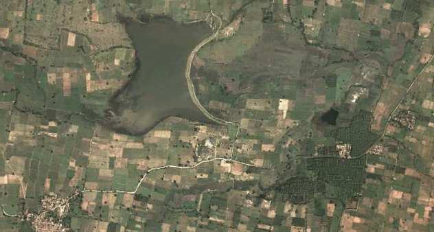
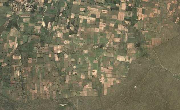
11 India Rice Crop Monitoring Example Google ear rth 11

12 RADARSAT-2 2 Data and Products MacDonald, Dettwiler and Associates Ltd (2011 (2011). All Rights Reserved. RADARSAT is an official mark of the Canadian Space Agency Rice Crop Growth Sequence 12 May 26 June 19 July 13 August 6 August 30 September 23 October 17 Time series of RADARSAT-2 Fine Quad data showing rice cropping from fallow fields in May-June through heading July-October.
13 Synergy of RISAT and RADARSAT-2 Rice Crop Monitoring RISAT and RADARSAT-2 can be combined in a virtual constellation for Increased spatial coverage to estimate crop area Increased re-visit to provide quicker rice-crop area information Crop classification, e.g. rice and jute RISAT Fine Resolution Stripmap Mode-1 (3 m resolution, 25 km swath) Fine Resolution Stripmap Mode-2 (12 m, quad-pol, 30 km swath) Medium Resolution ScanSAR (25 m resolution, 120 km swath) Coarse Resolution ScanSAR (50 m resolution, 240 km swath) High Resolution Spotlight Mode (2 m resolution, 10 km swath) RADARSAT-2 UltraFine (3 m resolution, 20 km swath) Fine quad-pol (10 m resolution, km swath) Standard (25 m resolution, 100 km swath) ScanSAR Narrow (50 m resolution, 300 km swath) SpotLight (0.8 m x 2.2 m resolution, 18 rg x 8 az km swath) 13


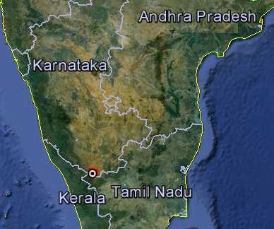
14 Rice Crop Monitoring Example A major rice growing area in state of Uttar Pradesh was selected for analysis using RISAT and RADARSAT-2 quadpolarized data 14
15 RISAT and RADARSAT-2 Provide Increased Spatial Coverage In a 25-day period, the region is approximately 50% covered using only RISAT (left). If RISAT and RADARSAT-2 are combined (right), the region is approximately 90% covered. Note that RISAT has a 25-day repeat cycle and RADARSAT-2 has a 24-day repeat cycle. The coverage is based on a fixed incidence angle. 15
16 RISAT and RADARSAT-2 Provide Faster Spatial Coverage Complete coverage using only RISAT requires 33 days (left). If RISAT and RADARSAT-2 are combined, complete coverage requires only15 days. Note that the coverage is based on using multiple incidence angles. 16
17 Summary RADARSAT-1/2 has a proven, operational capability for flood and agriculture monitoring India has been using RADARSAT data since 1998 for flood and agricultural monitoring RISAT and RADARSAT-2 can be combined to form a virtual constellation that allows: improved spatial coverage increased re-visit rapid respond to emergencies, e.g. flooding Looking ahead, the RADARSAT Constellation Mission is under development in Canada with launch planned for Three RADARSAT-2-like satellites will be in orbit and provide daily re-visit anywhere in the world. 17
RADARSAT-2 Modes and Applications
 RADARSAT-2 Modes and Applications Gordon Staples MDA Geospatial Services February 6, 2017 1 Introduction RADARSAT-2 was developed to meet operational needs via a versatile space segment and a responsive
Warren Cartwright, Product Manager MDA Geospatial Services, Canada
 Advanced InSAR Techniques for Urban Infrastructure Monitoring Warren Cartwright, Product Manager MDA Geospatial Services, Canada www.mdacorporation.com RESTRICTION ON USE, PUBLICATION OR DISCLOSURE OF
KONGSBERG SATELLITE SERVICES 2017 Line Steinbakk, Director Programs. Himmel og hav - Ålesund 3. Oktober 2017
 KONGSBERG SATELLITE SERVICES 2017 Line Steinbakk, Director Programs Himmel og hav - Ålesund 3. Oktober 2017 KSAT HQ IN TROMSØ 69N Established in 1967 Kongsberg Satellite Services since 2002 World leading
RADARSAT-2 Program Update Daniel De Lisle Canadian Space Agency
 RADARSAT-2 Program Update Daniel De Lisle Canadian Space Agency Presentation outline RADARSAT-1 Update RADARSAT-2 Mission description Mission Objectives System Characteristics Data Commercialization/Allocation
IMPACT OF BAQ LEVEL ON INSAR PERFORMANCE OF RADARSAT-2 EXTENDED SWATH BEAM MODES
 IMPACT OF BAQ LEVEL ON INSAR PERFORMANCE OF RADARSAT-2 EXTENDED SWATH BEAM MODES Jayson Eppler (1), Mike Kubanski (1) (1) MDA Systems Ltd., 13800 Commerce Parkway, Richmond, British Columbia, Canada, V6V
Affordable space based radar for homeland security
 Changing the economics of space Affordable space based radar for homeland security Adam Baker Brent Abbott Phil Whittaker Rachel Bird Luis Gomes Summary Why Radar? However: Radar data is expensive Users
RADARSAT-2 Image Quality and Calibration Update
 RADARSAT-2 Image Quality and Calibration Update by Dan Williams, Yiman Wang, Marielle Chabot, Pierre Le Dantec, Ron Caves, Yan Wu, Kenny James, Alan Thompson, Cathy Vigneron www.mdacorporation.com Image
RADARSAT-2 PRODUCT DESCRIPTION
 RADARSAT-2 PRODUCT DESCRIPTION Summary: This document defines the characteristics of RADARSAT-2 products. IMPORTANT NOTES: This document describes the characteristics of RADARSAT-2 Products. The product
RADARSAT-2 and RCM Conjunction Analysis and Mitigation Operations
 RADARSAT-2 and RCM Conjunction Analysis and Mitigation Operations Casey Lambert (MDA), Camille Decoust (MDA), Bryan Cooke (SED) www.mdacorporation.com Presentation Outline Introduction to RADARSAT-2 Collision
SAR Interferometry Capabilities of Canada's planned SAR Satellite Constellation
 SAR Interferometry Capabilities of Canada's planned SAR Satellite Constellation Dirk Geudtner, Guy Séguin,, Ralph Girard Canadian Space Agency RADARSAT Follow-on Program CSA is in the middle of a Phase
Concept of the future L-band SAR mission for wide swath SAR observation
 Concept of the future SAR mission for wide swath SAR observation A.Karasawa 1, Y.Okada 1, Y.Yokota 1, S.Nakamura 1 1) Mitsubishi Electric Corporation 1 Outline 1:Development of SAR systems in MELCO 2:Development
Review. Guoqing Sun Department of Geography, University of Maryland ABrief
 Review Guoqing Sun Department of Geography, University of Maryland gsun@glue.umd.edu ABrief Introduction Scattering Mechanisms and Radar Image Characteristics Data Availability Example of Applications
The Current Status and Brief Results of Engineering Model for PALSAR-2 onboard ALOS-2 and Science Project
 The Current Status and Brief Results of Engineering Model for PALSAR-2 onboard ALOS-2 and Science Project + The 16 th KC meeting Japan Aerospace Exploration Agency Masanobu Shimada, Yukihiro KANKAKU The
Cristina M. Surdu 1, Claude R. Duguay 2 and Diego Fernández Prieto 1
 Cristina M. Surdu 1, Claude R. Duguay 2 and Diego Fernández Prieto 1 1 European Space Agency, ESRIN, Italy 2 University of Waterloo, Ontario, Canada Objectives To document and analyze the response of High
DLR contribution and perspectives for JECAM
 DLR contribution and perspectives for JECAM Dr. Helmut Staudenrausch 1, Dr. Achim Roth 2 1 DLR Space Administration, Earth Observations helmut.staudenrausch@dlr.de 2 DLR, German Remote Sensing Data Center
Operational Space-Based Imaging Systems
 Operational Space-Based Imaging Systems R E M O T E S E N S I N G & G E O S PAT I A L A N A LY S I S L A B D O I : 2 0 A U G U S T, 2 0 1 6 Earth Observation Systems U.S. or foreign government systems
Satellite data for Maritime Operations. Andreas Hay Kaljord Project Manager Energy, Environment & Security
 Satellite data for Maritime Operations Andreas Hay Kaljord Project Manager Energy, Environment & Security Kongsberg Satellite Services (KSAT) World leading provider within our business area Supports 85
RADARSAT-2/RCM Synthetic Aperture Radar data exploitation for military geomatics via ArcGIS
 RADARSAT-2/RCM Synthetic Aperture Radar data exploitation for military geomatics via ArcGIS Presented by: Greg Barrie, Defence Scientist, DRDC Ottawa October 17, 2018 Defence R&D Canada (DRDC) What we
The Sentinel-1 Constellation
 The Sentinel-1 Constellation Evert Attema, Sentinel-1 Mission & System Manager AGRISAR and EAGLE Campaigns Final Workshop 15-16 October 2007 ESA/ESTECNoordwijk, The Netherlands Sentinel-1 Programme Sentinel-1
CSA Report on Earth Observation
 CSA Report on Earth Observation Presented at Shanghai, China May 13 17, 2013 Dr. Satish K. Srivastava WGCV Chair & CSA Member of WGCV Page 1 RADARSAT-1 Program Status Since 22:30 UTC March 29, 2013, it
Introduction to Radar
 National Aeronautics and Space Administration ARSET Applied Remote Sensing Training http://arset.gsfc.nasa.gov @NASAARSET Introduction to Radar Jul. 16, 2016 www.nasa.gov Objective The objective of this
Introduction to KOMPSAT
 Introduction to KOMPSAT September, 2016 1 CONTENTS 01 Introduction of SIIS 02 KOMPSAT Constellation 03 New : KOMPSAT-3 50 cm 04 New : KOMPSAT-3A 2 KOMPSAT Constellation KOMPSAT series National space program
Automated Damage Analysis from Overhead Imagery
 Automated Damage Analysis from Overhead Imagery EVAN JONES ANDRE COLEMAN SHARI MATZNER Pacific Northwest National Laboratory 1 PNNL FY2015 at a Glance $955 million in R&D expenditures 4,400 scientists,
Geospatial Vision and Policies Korean Industry View 26 November, 2014 SI Imaging Services
 Geospatial Vision and Policies Korean Industry View 26 November, 2014 SI Imaging Services Distribution Limitation, SI Imaging Services Proprietary Data : The data contained in this document, without the
RADAR SATELLITES AND MARITIME DOMAIN AWARENESS
 RADAR SATELLITES AND MARITIME DOMAIN AWARENESS J.K.E. Tunaley Corporation, 114 Margaret Anne Drive, Ottawa, Ontario K0A 1L0 (613) 839-7943 Report Documentation Page Form Approved OMB No. 0704-0188 Public
KOMPSAT Constellation. November 2012 Satrec Initiative
 KOMPSAT Constellation November 2012 Satrec Initiative KOMPSAT Constellation KOMPSAT National program Developed and operated by KARI (Korea Aerospace Research Institute) Dual use : Government & commercial
Playa del Rey, California InSAR Ground Deformation Monitoring Interim Report H
 Playa del Rey, California InSAR Ground Deformation Monitoring Interim Report H Ref.: RV-14524 Doc.: CM-168-01 January 31, 2013 SUBMITTED TO: Southern California Gas Company 555 W. Fifth Street (Mail Location
MULTI-CHANNEL SAR EXPERIMENTS FROM THE SPACE AND FROM GROUND: POTENTIAL EVOLUTION OF PRESENT GENERATION SPACEBORNE SAR
 3 nd International Workshop on Science and Applications of SAR Polarimetry and Polarimetric Interferometry POLinSAR 2007 January 25, 2007 ESA/ESRIN Frascati, Italy MULTI-CHANNEL SAR EXPERIMENTS FROM THE
Synthetic Aperture Radar for Rapid Flood Extent Mapping
 National Aeronautics and Space Administration ARSET Applied Remote Sensing Training http://arset.gsfc.nasa.gov @NASAARSET Synthetic Aperture Radar for Rapid Flood Extent Mapping Sang-Ho Yun ARIA Team Jet
ROSCOSMOS Agency Report. 36 th CEOS WGCV Plenary May 2013, Shanghai, China
 ROSCOSMOS Agency Report 36 th CEOS WGCV Plenary 13-17 May 2013, Shanghai, China Denisov Pavel «Research Center for Earth Operative Monitoring» Joint-Stock Company «Russian Space Systems» 1 PURPOSE AND
Application Potential of Planned SAR Satellites a Preview
 PREPRINT/PRÉTIRAGE Application Potential of Planned SAR Satellites a Preview J.J. van der Sanden 1, P. Budkewitsch 1, R. Landry 1, M.J. Manore 2, H. McNairn 1, T.J. Pultz 1, and P.W. Vachon 1 1 Canada
Not just another high resolution satellite sensor
 Global Forest Change Published by Hansen, Potapov, Moore, Hancher et al. http://earthenginepartners.appspot.com/science-2013-global-forest Rapideye Not just another high resolution satellite sensor 5 satellites
*For International Stewardship of the Maritime Environment and its Resources. Photo
 *For International Stewardship of the Maritime Environment and its Resources *For Maritime Safety *For Security Photo # Providing Environmental Monitoring* # Increasing Security* # Enabling Safety Efforts*
European Space Agency and IPY
 European Space Agency and IPY ESA supports IPY 2007-2008 activities: First ESA step was a dedicated Announcement Opportunity (AO) for EO data provision in support IPY, released in 2006, with data provision
SARscape for ENVI. A Complete SAR Analysis Solution
 SARscape for ENVI A Complete SAR Analysis Solution IDL and ENVI A Foundation for SARscape IDL The Data Analysis & Visualization Platform Data Access: IDL supports virtually every data format, type and
TerraSAR-X Applications Guide
 TerraSAR-X Applications Guide Extract: Maritime Monitoring: Ship Detection April 2015 Airbus Defence and Space Geo-Intelligence Programme Line Maritime Monitoring: Ship Detection Issue Maritime security
COPERNICUS COLLABORATIVE GROUND SEGMENT TO SUPPORT MARITIME SITUATIONAL AWARENESS
 COPERNICUS COLLABORATIVE GROUND SEGMENT TO SUPPORT MARITIME SITUATIONAL AWARENESS D. Krause*, E. Schwarz, H. Damerow, German Aerospace Center (DLR), German Remote Sensing Data Center (DFD), Kalkhorstweg
ERS/ENVISAT ASAR Data Products and Services
 ERS/ENVISAT ASAR Data Products and Services Andrea Celentano Business Manager celentan@eurimage.com What is Eurimage? Founded in 1989 Current shareholders: Since 1989 Commercial Partner of the European
Disruptive technologies and future trends of small satellites
 2016 SSTL Disruptive technologies and future trends of small satellites Luis Gomes Director of EO & science Surrey Satellite Technology Limited Radio Communication June 1978 2016 SSTL The DMC and RapidEye
The Radar Ortho Suite is an add-on to Geomatica. It requires Geomatica Core or Geomatica Prime as a pre-requisite.
 Technical Specifications Radar Ortho Suite The Radar Ortho Suite includes rigorous and rational function models developed to compensate for distortions and produce orthorectified radar images. Distortions
The Biomass Mission, status of the satellite system
 The Biomass Mission, status of the satellite system M. Arcioni, P. Bensi, M. Fehringer, F. Fois, F. Heliere, K. Scipal PolInSAR/Biomass Meeting 2015, ESRIN 29/01/2015 1. Key facts (lifetime, duty cycle
ALOS and PALSAR. Masanobu Shimada
 ALOS and PALSAR Masanobu Shimada Earth Observation Research Center, National Space Development Agency of Japan, Harumi 1-8-10, Harumi island triton square office tower X 22, Chuo-Ku, Tokyo-To, Japan, 104-6023,
KONGSBERG SATELLITE SERVICES Earth Observation for Maritime Operations Current Capabilities and Future Potential
 KONGSBERG SATELLITE SERVICES 2017 Earth Observation for Maritime Operations Current Capabilities and Future Potential Andreas Hay Kaljord Project Manager KSAT HQ IN TROMSØ - 69N WELCOME TO TROMSØ Established
TerraSAR-X Applications Guide
 TerraSAR-X Applications Guide Extract: Change Detection and Monitoring: Geospatial / Image Intelligence April 2015 Airbus Defence and Space Geo-Intelligence Programme Line Change Detection and Monitoring:
SAR Remote Sensing (Microwave Remote Sensing)
") iirs SAR Remote Sensing (Microwave Remote Sensing) Synthetic Aperture Radar Shashi Kumar shashi@iirs.gov.in Electromagnetic Radiation Electromagnetic radiation consists of an electrical field(e) which
iirs SAR Remote Sensing (Microwave Remote Sensing) Synthetic Aperture Radar Shashi Kumar shashi@iirs.gov.in Electromagnetic Radiation Electromagnetic radiation consists of an electrical field(e) which
Introduc)on*to*Asia/RiCE* Technical*Demonstra)on*Sites*II.** Japan,*Indonesia,*Vietnam*
on*to*Asia/RiCE* Technical*Demonstra)on*Sites*II.** Japan,*Indonesia,*Vietnam*") Introduc)on*to*Asia/RiCE* Technical*Demonstra)on*Sites*II.** Japan,*Indonesia,*Vietnam* Kei$Oyoshi 1,$Nobuhiro$Tomiyama 2,$Toshio$Okumura 2,$Shinichi$Sobue 1,2,$ Wahyu$Supriatna 3,$Rizatus$Shofiya? 3,$Lam$Dao$Nguyen
Introduc)on*to*Asia/RiCE* Technical*Demonstra)on*Sites*II.** Japan,*Indonesia,*Vietnam* Kei$Oyoshi 1,$Nobuhiro$Tomiyama 2,$Toshio$Okumura 2,$Shinichi$Sobue 1,2,$ Wahyu$Supriatna 3,$Rizatus$Shofiya? 3,$Lam$Dao$Nguyen
Rapideye (2008 -> ) Not just another high resolution satellite sensor. 5 satellites RapidEye constellation. 5 million km² daily collection capacity
 Not just another high resolution satellite sensor. 5 satellites RapidEye constellation. 5 million km² daily collection capacity") Rapideye (2008 -> ) Not just another high resolution satellite sensor 5 satellites RapidEye constellation 5 million km² daily collection capacity Price: $1.40 / sq km ($2.50 rectified) Orbit: http://www.youtube.com/watch?feature=player_embedded&v=ovpulctoqgs
Rapideye (2008 -> ) Not just another high resolution satellite sensor 5 satellites RapidEye constellation 5 million km² daily collection capacity Price: $1.40 / sq km ($2.50 rectified) Orbit: http://www.youtube.com/watch?feature=player_embedded&v=ovpulctoqgs
TerraSAR-X Calibration Status 2 Years in Flight
 2 Years in Flight Dirk Schrank, Marco Schwerdt, Markus Bachmann, Björn Döring, Clemens Schulz November 2009 CEOS 09 VG 1 Calibration Tasks Performed 2009 Introduction Challenge Schedule Re-Calibration
Biomass, a polarimetric interferometric P-band SAR mission
 Biomass, a polarimetric interferometric P-band SAR mission M. Arcioni, P. Bensi, M. Fehringer, F. Fois, F. Heliere, N. Miranda, K. Scipal Fringe 2015, ESRIN 27/03/2015 The Biomass Mission 1. Biomass was
SARscape Modules for ENVI
 Visual Information Solutions SARscape Modules for ENVI Read, process, analyze, and output products from SAR data. ENVI. Easy to Use Tools. Proven Functionality. Fast Results. DEM, based on TerraSAR-X-1
7.7 TerraSAR-X & TanDEM-X
 7.7 TerraSAR-X & TanDEM-X Two Innovative Remote Sensing Stars for space-borne Earth Observation Vorlesung Wolfgang Keydel Microwaves and Radar Institute, German Aerospace Research Center (DLR), D-82230
EMSA Additional Dataset Status 31 st March 2015
 EMSA Additional Dataset Status 31 st March 2015 DWH_MG2_EMSA_ADD_001a: _rush_optical_hr1... 2 DWH_MG2_EMSA_ADD_001b: _rush_optical_hr2... 3 DWH_MG2_EMSA_ADD_002a: ew acquisition_rush_optical_hr1... 4 DWH_MG2_EMSA_ADD_002b:
Detection of traffic congestion in airborne SAR imagery
 Detection of traffic congestion in airborne SAR imagery Gintautas Palubinskas and Hartmut Runge German Aerospace Center DLR Remote Sensing Technology Institute Oberpfaffenhofen, 82234 Wessling, Germany
COSMO-skymed, TerraSAR-X, and RADARSAT-2 geolocation accuracy after compensation for earth-system effects
 Zurich Open Repository and Archive University of Zurich Main Library Strickhofstrasse 9 CH-857 Zurich www.zora.uzh.ch Year: COSMO-skymed, TerraSAR-X, and RADARSAT- geolocation accuracy after compensation
Indian Remote Sensing Satellites
 Resourcesat-1 Indian Remote Sensing Satellites -Current & Future Resourcesat Missions - Presented by: Timothy J. Puckorius Chairman & CEO EOTec 1 Presentation Topics India s Earth Observation Heritage
Copernicus Introduction Lisbon, Portugal 13 th & 14 th February 2014
 Copernicus Introduction Lisbon, Portugal 13 th & 14 th February 2014 Contents Introduction GMES Copernicus Six thematic areas Infrastructure Space data An introduction to Remote Sensing In-situ data Applications
WHAT IS NEXT IN EARTH OBSERVATION. SkyMed Mission
 WHAT IS NEXT IN EARTH OBSERVATION COSMO-SkyMed SkyMed Mission Paolo Ammendola Italian Space Agency Florence, Sept. 19, 2001 ammendola@asi asi.it THE NEEDS Market studies indicate that the value of the
Polarisation Capabilities and Status of TerraSAR-X
 Polarisation Capabilities and Status of TerraSAR-X Irena Hajnsek, Josef Mittermayer, Stefan Buckreuss, Kostas Papathanassiou German Aerospace Center Microwaves and Radar Institute irena.hajnsek@dlr.de
Big picture with KOMPSAT KOMPSAT-3A / KOMPSAT-3 / KOMPSAT-5 / KOMPSAT-2
 Big picture with KOMPSAT KOMPSAT-3A / KOMPSAT-3 / KOMPSAT-5 / KOMPSAT-2 Big picture with KOMPSAT Introduction SI Imaging Services (SIIS) is the exclusive worldwide marketing and sales representative of
CSA Report on Earth Observation
 CSA Report on Earth Observation Dr. Satish K. Srivastava WGCV Chair & CSA Member of WGCV Canadian Space Agency Presented at College Park, MD, USA Sep 30 th to Oct 2 nd, 2014 RADARSAT-2 Spacecraft Health
ISRO s EARTH OBSERVATION SYSTEM (updates from last Plenary) AS Kiran Kumar ISRO, INDIA
 AS Kiran Kumar ISRO, INDIA") ISRO s EARTH OBSERVATION SYSTEM (updates from last Plenary) AS Kiran Kumar ISRO, INDIA The 24 th CEOS Plenary Rio de Janeiro, Brazil 12-15 October, 2010 1 Four Decades of Indian Space Programme 30LV Missions
ISRO s EARTH OBSERVATION SYSTEM (updates from last Plenary) AS Kiran Kumar ISRO, INDIA The 24 th CEOS Plenary Rio de Janeiro, Brazil 12-15 October, 2010 1 Four Decades of Indian Space Programme 30LV Missions
SUGAR_GIS. From a user perspective. Provides spatial distribution of a wide range of sugarcane production data in an easy to use and sensitive way.
 SUGAR_GIS From a user perspective What is Sugar_GIS? A web-based, decision support tool. Provides spatial distribution of a wide range of sugarcane production data in an easy to use and sensitive way.
SAR missions for oceanography at the European Space Agency
 SAR missions for oceanography at the European Space Agency ERS-1, ERS-2, Envisat, Sentinel-1A, Sentinel-1B, ESA 3 rd Party Missions (ALOS) Prepared by ESA teams and ESA supporting companies ESA and SAR
Synthetic aperture RADAR (SAR) principles/instruments October 31, 2018
 principles/instruments October 31, 2018") GEOL 1460/2461 Ramsey Introduction to Remote Sensing Fall, 2018 Synthetic aperture RADAR (SAR) principles/instruments October 31, 2018 I. Reminder: Upcoming Dates lab #2 reports due by the start of next
GEOL 1460/2461 Ramsey Introduction to Remote Sensing Fall, 2018 Synthetic aperture RADAR (SAR) principles/instruments October 31, 2018 I. Reminder: Upcoming Dates lab #2 reports due by the start of next
Aquarius/SAC-D and Soil Moisture
 Aquarius/SAC-D and Soil Moisture T. J. Jackson P. O Neill February 24, 2011 Aquarius/SAC-D and Soil Moisture + L-band dual polarization + Combined active and passive Coarse spatial resolution (~100 km)
Canadian Space Agency program update
 Canadian Space Agency program update Briefing to the meeting of the Expert Team on Satellite Systems (ET-SAT-11) Geneva, 4 April 2017 Guennadi Kroupnik Canadian Space Agency RADARSAT-2: CURRENT OPERATIONAL
da Vinci Executive Briefing
 da Vinci Executive Briefing da Vinci program leveraging superintelligence to empower Humanity SEPTEMBER, 2016 PREPARED BY: BILLIONAIRE BUSINESS ENTERPRISES INC. PROPOSAL NUMBER: 2016 0903 RESTRICTION ON
Sentinel-1 Overview. Dr. Andrea Minchella
 Dr. Andrea Minchella 21-22/01/2016 ESA SNAP-Sentinel-1 Training Course Satellite Applications Catapult - Electron Building, Harwell, Oxfordshire Contents Sentinel-1 Mission Sentinel-1 SAR Modes Sentinel-1
Imagery Archive Works
 USDA How Satellite the Imagery USDA s Archive Satellite Imagery Archive Works A. What is the USDA Satellite Imagery Archive? B. What are the benefits of participating in the USDA Archive? C. What types
Sentinel-1 System Overview
 Sentinel-1 System Overview Dirk Geudtner, Rámon Torres, Paul Snoeij, Malcolm Davidson European Space Agency, ESTEC Global Monitoring for Environment and Security (GMES) EU-led program aiming at providing
India recently successfully launched its PSLV-C16 rocked that carried into orbit the latest remote
 India recently successfully launched its PSLV-C16 rocked that carried into orbit the latest remote sensing satellite REsourcesat-2 that would study and help manage natural resources along with two Nano
Rich Data, Cheap Satellites
 SSC17-XI-06 Rich Data, Cheap Satellites Luis Gomes, Nimal Navarthinam, Andrew Cawthorne, Alex da Silva Curiel Surrey Satellite Technology Limited 20 Stephenson Road, Guildford, GU2 7YE, United Kingdom;
NovaSAR-S - Bringing Radar Capability to the Disaster Monitoring Constellation
 Changing the economics of space NovaSAR-S - Bringing Radar Capability to the Disaster Monitoring Constellation SSTL: Philip Davies, Phil Whittaker, Rachel Bird, Luis Gomes, Ben Stern, Prof Sir Martin Sweeting
Soil moisture retrieval using ALOS PALSAR
 Soil moisture retrieval using ALOS PALSAR T. J. Jackson, R. Bindlish and M. Cosh USDA ARS Hydrology and Remote Sensing Lab, Beltsville, MD J. Shi University of California Santa Barbara, CA November 6,
Prague - 29 June 2009 A. COLETTA COLETTA. COSMO-SkyMed Mission: COSMO-SkyMed Mission. Application and Data Access
 A. A. COLETTA COLETTA COSMO-SkyMed COSMO-SkyMed Mission Mission Manager Manager ITALIAN ITALIAN SPACE SPACE AGENCY AGENCY COSMO-SkyMed Mission: Application and Data Access The COSMO-SkyMed PROGRAMME The
COSMO-SkyMed Mission Status Presented by Fabrizio BATTAZZA (ASI)
") COSMO-SkyMed Mission Status Presented by Fabrizio BATTAZZA (ASI) COSMO-1 & COSMO-2 LAUNCHES FIRST SATELLITE OF THE CONSTELLATION SUCCESSFULLY LAUNCHED 08 June 2007 03:35 (GMT) Vandenberg U.S.A. Air Force
COSMO-SkyMed Mission Status Presented by Fabrizio BATTAZZA (ASI) COSMO-1 & COSMO-2 LAUNCHES FIRST SATELLITE OF THE CONSTELLATION SUCCESSFULLY LAUNCHED 08 June 2007 03:35 (GMT) Vandenberg U.S.A. Air Force
Calibration Assessment of RADARSAT-2 Polarimetry Using High Precision Transponders
 Calibration Assessment of RADARSAT-2 Polarimetry Using High Precision Transponders R Touzi, S Côté, RK Hawkins CCRS/CSA Acknowledgments S Nedelcu (CCRS) S Muir (CSA) 1 Outline-Polarimetric RADARSAT-2 Independent
TanDEM-X: Mission Status & Scientific Contribution
 TanDEM-X: Mission Status & Scientific Contribution Irena Hajnsek 1/2, Gerhard Krieger 1, Kostas Papathanassiou 1, Stefan Baumgartner 1, Marc Rodriguez-Cassola 1, Pau Prats 1, Maria Sanjuan Ferrer 1, Florian
Canadian Space Agency Contribution to STG
 Canadian Space Agency Contribution to STG Canadian Space Agency 1 STG5 Geneva, Nov 30 to Dec 2, 2009 2 Canadian Space Agency ASAP Portefolio: Name Frozen Baseline Sea Ice Min and Max Snapshots Fine Image
PAZ Product Definition
 PAZ Product Definition CALVAL Centre Juan Manuel Cuerda Muñoz, Javier del Castillo Mena, Adolfo López Pescador, Nuria Gimeno Martínez, Nuria Casal Vázquez, Patricia Cifuentes Revenga, Marcos García Rodríguez,
KEY TECHNOLOGY DEVELOPMENT FOR THE ADVENACED LAND OBSERVING SATELLITE
 KEY TECHNOLOGY DEVELOPMENT FOR THE ADVENACED LAND OBSERVING SATELLITE Takashi HAMAZAKI, and Yuji OSAWA National Space Development Agency of Japan (NASDA) hamazaki.takashi@nasda.go.jp yuji.osawa@nasda.go.jp
An Introduction to Geomatics. Prepared by: Dr. Maher A. El-Hallaq خاص بطلبة مساق مقدمة في علم. Associate Professor of Surveying IUG
 An Introduction to Geomatics خاص بطلبة مساق مقدمة في علم الجيوماتكس Prepared by: Dr. Maher A. El-Hallaq Associate Professor of Surveying IUG 1 Airborne Imagery Dr. Maher A. El-Hallaq Associate Professor
NEXTMAP. P-Band. Airborne Radar Imaging Technology. Key Benefits & Features INTERMAP.COM. Answers Now
 INTERMAP.COM Answers Now NEXTMAP P-Band Airborne Radar Imaging Technology Intermap is proud to announce the latest advancement of their Synthetic Aperture Radar (SAR) imaging technology. Leveraging over
SARscape 4.1 Supported Sensors/Products (October 2008)
") SARscape 4.1 Supported Sensors/Products (October 2008) ALOS PALSAR (provided by JAXA) In case of RAW (level 1.0) data, import is carried out within the Focusing Module. PALSAR RAW data in CEOS standard
SARscape 4.1 Supported Sensors/Products (October 2008) ALOS PALSAR (provided by JAXA) In case of RAW (level 1.0) data, import is carried out within the Focusing Module. PALSAR RAW data in CEOS standard
The use of satellite images to forecast agricultural
 The use of satellite images to forecast agricultural Luxembourg, 12.03.2014 r. Tomasz Milewski NUTS for Poland: NUTS 1 macro-regions (grup of province, voivodships) (6), NUTS 2 - regions (province,
RADARSAT and ENVISAT provide wide-swath coverage
 IEEE TRANSACTIONS ON GEOSCIENCE AND REMOTE SENSING, VOL. 42, NO. 1, JANUARY 2004 3 A New Hybrid-Beam Data Acquisition Strategy to Support ScanSAR Radiometric Calibration Ian G. Cumming, Member, IEEE, and
9/12/2011. Training Course Remote Sensing Basic Theory & Image Processing Methods September 2011
 Training Course Remote Sensing Basic Theory & Image Processing Methods 19 23 September 2011 Popular Remote Sensing Sensors & their Selection Michiel Damen (September 2011) damen@itc.nl 1 Overview Low resolution
The Ability of a Small Satellite Constellation to Tip and Cue Other Commercial Assets
 Changing the economics of space The Ability of a Small Satellite Constellation to Tip and Cue Other Commercial Assets Becky Cudzilo - Surrey Satellite US, LLC K.C. Foley - GeoEye, Inc. Chandler Smith -
SAOCOM MISSION OVERVIEW
 COMISION NACIONAL DE ACTIVIDADES ESPACIALES (The Argentinean National Commission of Space Activities) SAOCOM MISSION OVERVIEW Laura Frulla, J. Medina, J. Milovich, G. R. Ortega, Marc Thibeault CONAE November
PEGASUS : a future tool for providing near real-time high resolution data for disaster management. Lewyckyj Nicolas
 PEGASUS : a future tool for providing near real-time high resolution data for disaster management Lewyckyj Nicolas nicolas.lewyckyj@vito.be http://www.pegasus4europe.com Overview Vito in a nutshell GI
The TerraSAR-L System and Mission Objectives
 The TerraSAR-L System and Mission Objectives Manfred Zink & Ramon Torres TerraSAR Project, ESA-ESTEC Keplerlaan 1, 2200 AG, Noordwijk, The Netherlands Tel: +31 71565 3038, Fax: +31 71565 3191, Email: Manfred.Zink@esa.int
Swath Guidance Technology. Ron C. Johnson
 Swath Guidance Technology by Ron C. Johnson Widespread acceptance of new information technologies in agriculture may still be a long way off. But some producers and custom applicators are beginning to
UNISCAN AND ALICE-SC GROUND STATIONS AND DEVELOPMENT OF THEIR NETWORKS
 UNISCAN AND ALICE-SC GROUND STATIONS AND DEVELOPMENT OF THEIR NETWORKS Gershenzon V.E., Gershenzon O.N. R&D Center ScanEx Commission WG IV/9 KEY WORDS: Uniscan, Alice-SC, Stations, Geo-Portals ABSTRACT:
The ERS contribution to Oil Spill Monitoring - From R&D towards an operational service -
 The ERS contribution to Oil Spill Monitoring - From R&D towards an operational service - J.P. Pedersen, T.Bauna, L.G. Seljelv, L. Steinbakk, R.T.Enoksen Tromsø Satellite Station, N-9291 Tromsø, Norway
Sources of Geographic Information
 Sources of Geographic Information Data properties: Spatial data, i.e. data that are associated with geographic locations Data format: digital (analog data for traditional paper maps) Data Inputs: sampled
Q&A Earth-i Q&A Earth-i Observing the Earth Question: Can you provide an over view of Ear th-i s current capabilities and expertise?
 Q&A Earth-i Las Vegas. Photo courtesy of Earth-i Q&A Richard Blain: CEO, Earth-i Observing the Earth Earth-i is one of Europe s most prominent NewSpace companies supplying high resolution image data and
The studies began when the Tiros satellites (1960) provided man s first synoptic view of the Earth s weather systems.
 provided man s first synoptic view of the Earth s weather systems.") Remote sensing of the Earth from orbital altitudes was recognized in the mid-1960 s as a potential technique for obtaining information important for the effective use and conservation of natural resources.
Remote sensing of the Earth from orbital altitudes was recognized in the mid-1960 s as a potential technique for obtaining information important for the effective use and conservation of natural resources.
 Performance Comparison between Dual Polarimetric and Fully Polarimetric data for DInSAR Subsidence monitoring Dani Monells, Jordi J. Mallorquí Universitat Politècnica de Catalunya, Departament de Teoria
Use of Synthetic Aperture Radar images for Crisis Response and Management
 2012 IEEE Global Humanitarian Technology Conference Use of Synthetic Aperture Radar images for Crisis Response and Management Gerardo Di Martino, Antonio Iodice, Daniele Riccio, Giuseppe Ruello Department
Monitoring Natural Disasters with Small Satellites Smart Satellite Based Geospatial System for Environmental Protection
 Monitoring Natural Disasters with Small Satellites Smart Satellite Based Geospatial System for Environmental Protection Krištof Oštir, Space-SI, Slovenia Contents Natural and technological disasters Current