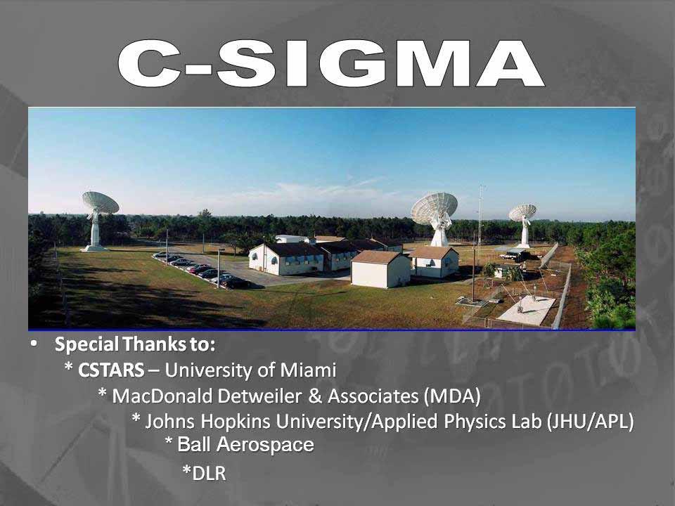
*For International Stewardship of the Maritime Environment and its Resources. Photo
|
|
|
- Julius Joseph
- 5 years ago
- Views:
Transcription

1 *For International Stewardship of the Maritime Environment and its Resources *For Maritime Safety *For Security Photo


2 # Providing Environmental Monitoring* # Increasing Security* # Enabling Safety Efforts* # Guarding Natural Resources* Fish Energy Mineral *Maritime & Otherwise

3 # Not a Program # Not a Canned Solution # Not Even a Proposal # Governance is NOT Discussed # Is an Technology Examination # Is an Awareness Effort A Call to Action!
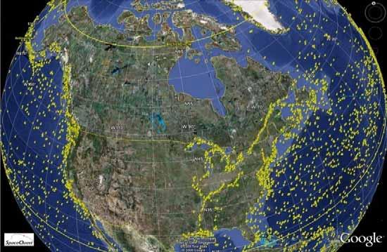
4 LiMES
5
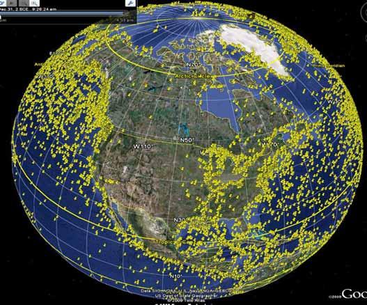
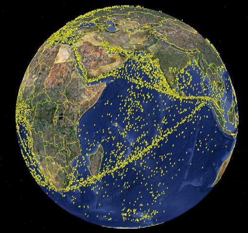
6 LiMES
7

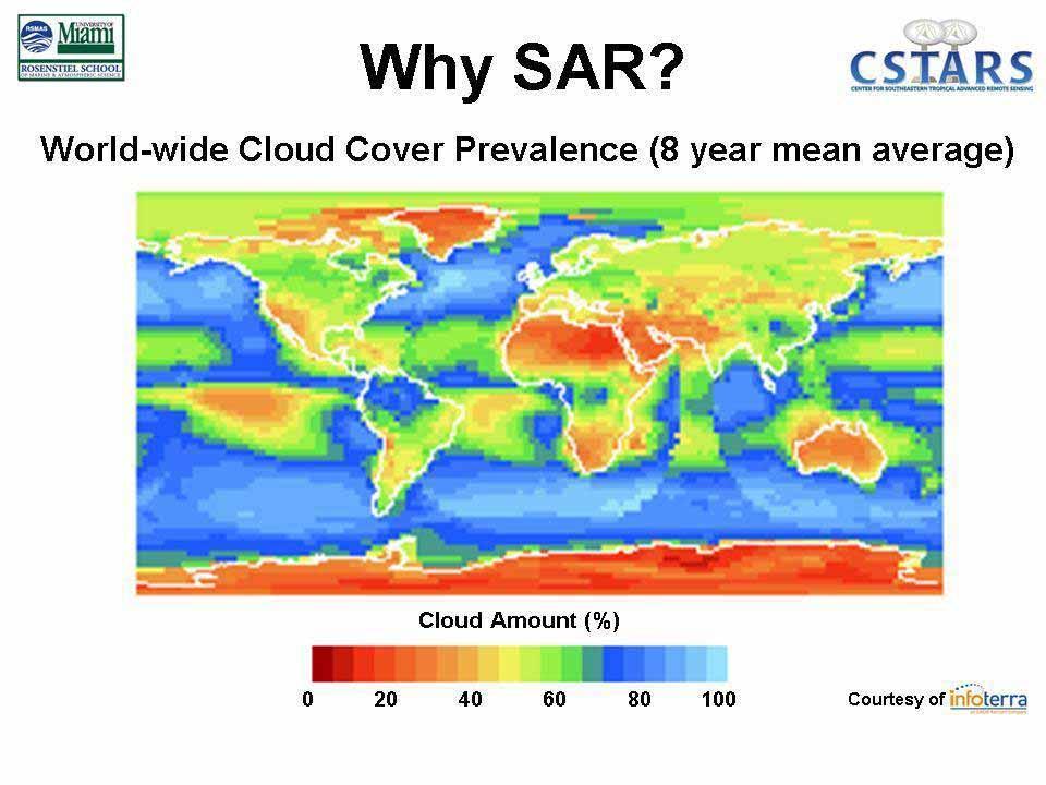
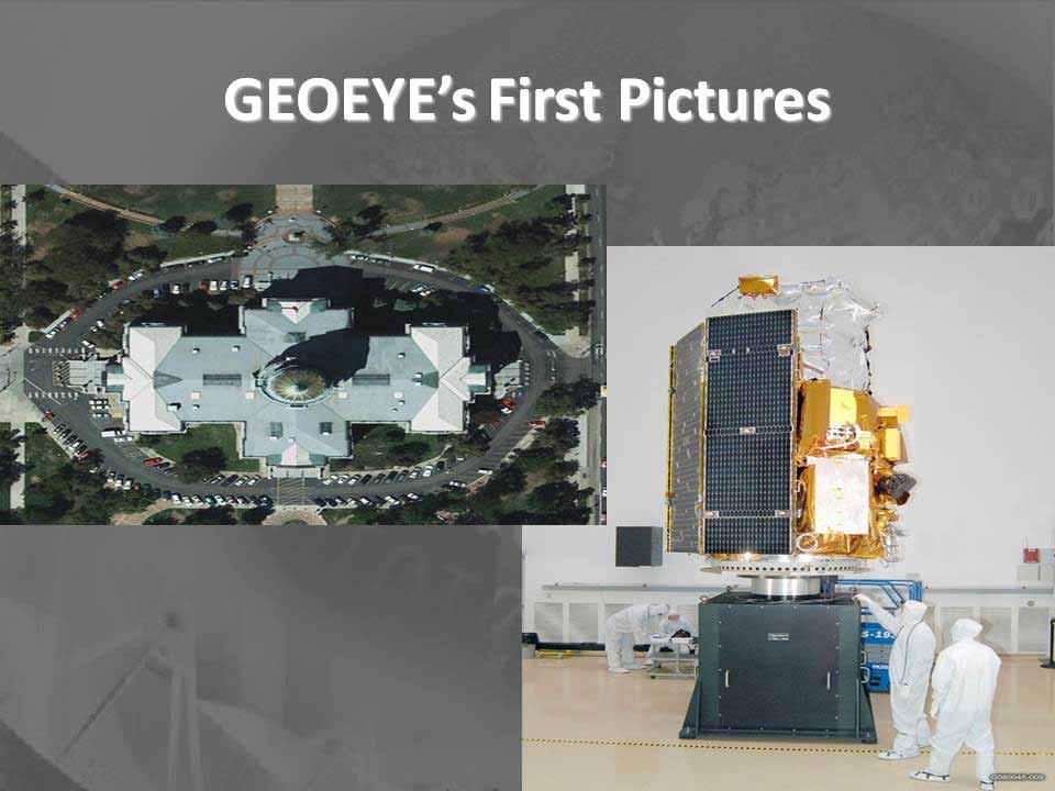
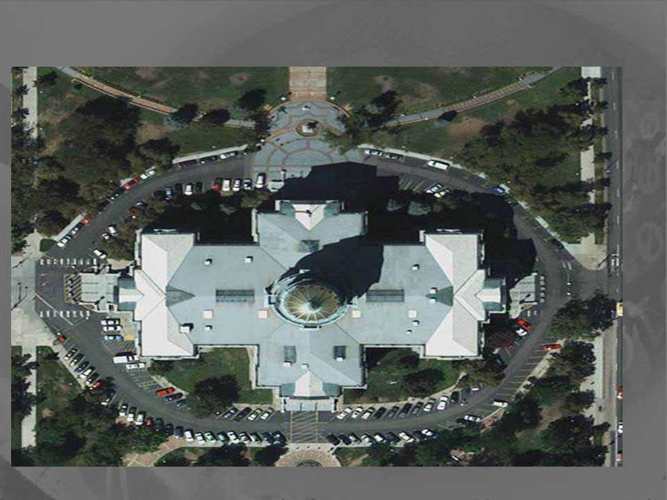
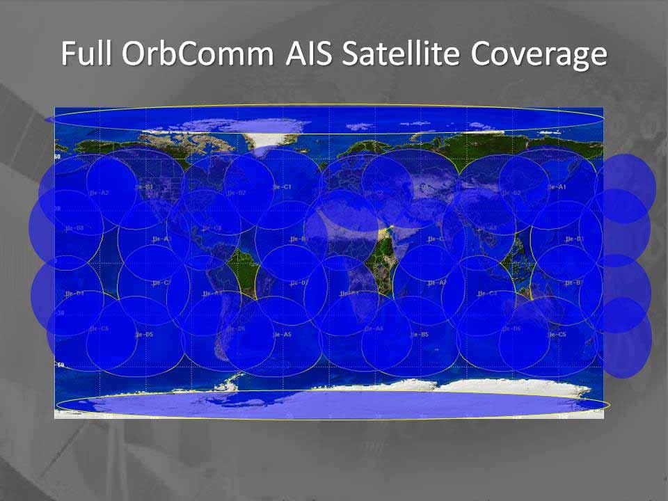
8 *From One Small, Cheap Satellite
9
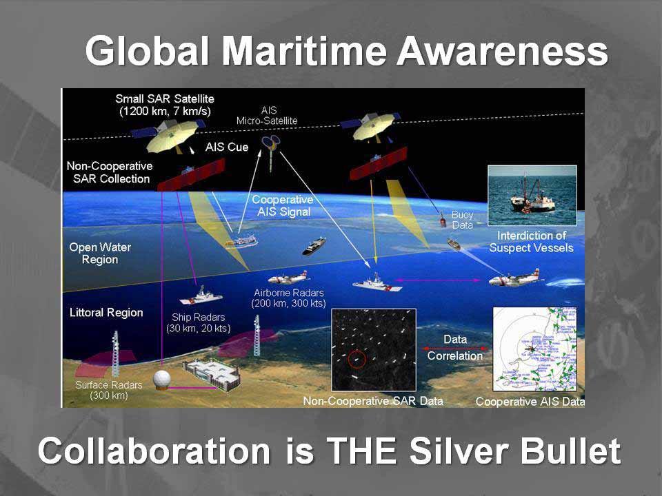
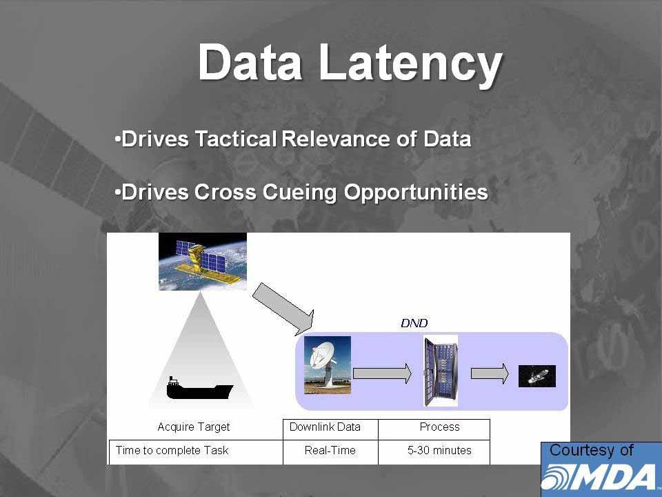
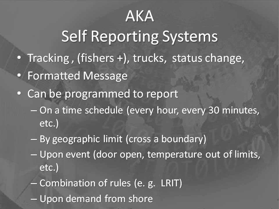
10 Important Factors re Maritime Awareness from Space Integrated into Existing Surveillance Efforts Data Latency Drives Relevance of data & Provides cross-cueing opportunities Applications: Detection: Wide Area Surveillance requires reliable detection Largest Possible Swath & Shortest Revisit Time Classification: AIS & Other Self Reporting Systems (or lack thereof) Identification: High Resolution EO/IR
11
12

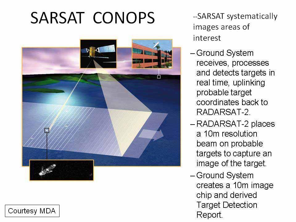
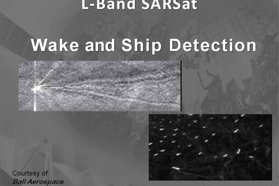
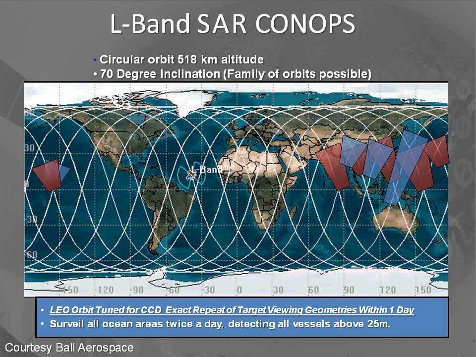
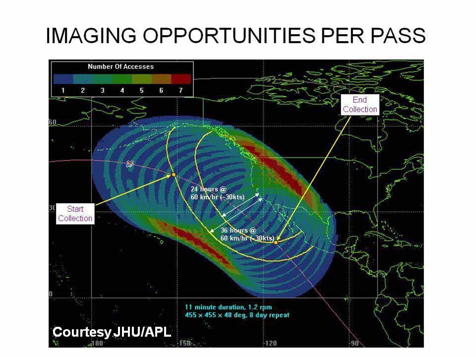
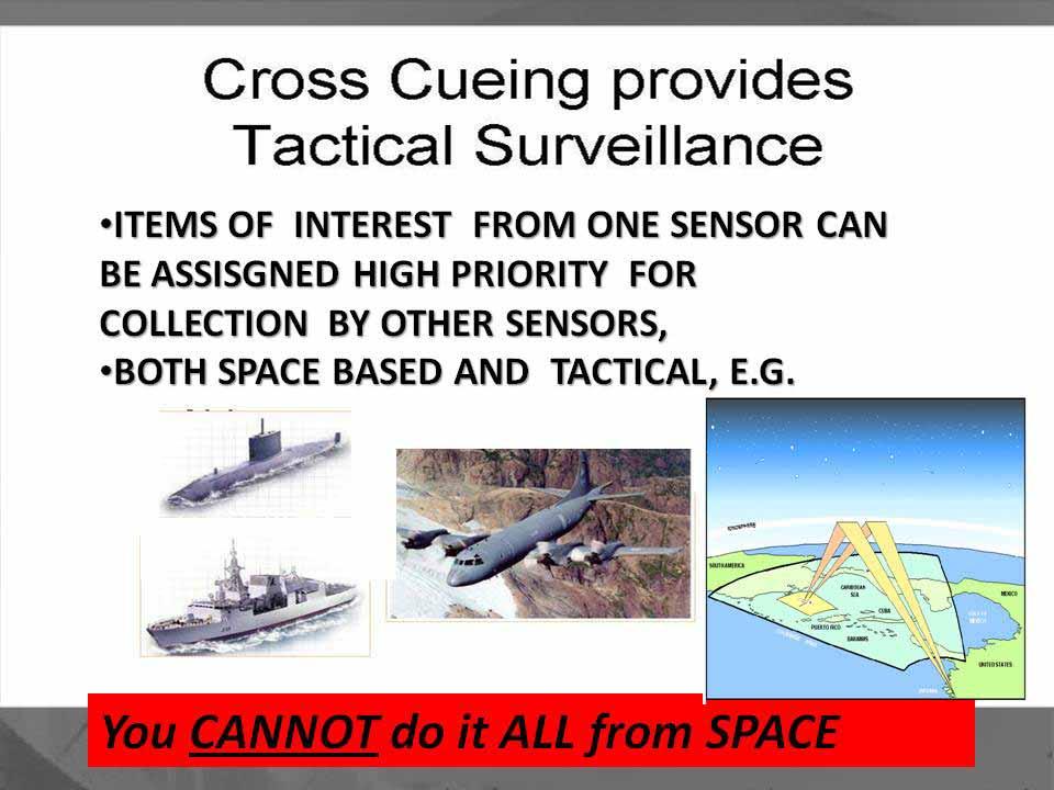
13 1 st Part of C-SIGMA Equation SARSats Space Based SAR Provides Global Access All Weather, Day Night, Dynamically Tasked, Tactical Resolution SAR Optimized for large area collections Cues higher resolution systems Tipping & Cueing Repeat Orbit Nominal 24 Hour Repeat Optimal CCD over wide area Maritime Domain Awareness Non SAR Mode for Vessel Detection SAR mode for wake detection Simultaneous SAR Imaging & Tagging TPED using existing ISR Infrastructure Theater tasking/downlink Automated CCD Processing Courtesy of Ball Aerospace Analysis of Change Indicates Potential Activities of Interest
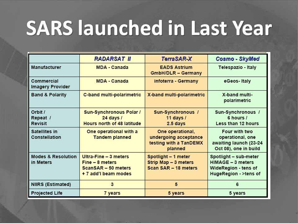
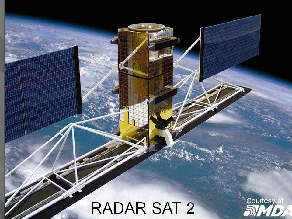
14 Recent SARSATs RadarSat 2 TerraSar X Cosmos Skymed
15
16
 Canadian Mission: coastal surveillance, oil exploration TerraSAR-X Germany (1 now, 4 in CY15) World s most geometrically accurate imaging system Excellent data")
17 Commercial Space Radar Capabilities RADARSAT-2 Canada (1 now, 3 in CY15) Large scan area well-suited for ocean surveillance Quad Polarimetry 4 images simultaneously w/different combinations Large collection capacity (28 min/orbit) Canadian Mission: coastal surveillance, oil exploration TerraSAR-X Germany (1 now, 4 in CY15) World s most geometrically accurate imaging system Excellent data quality and RNIIRS levels Great change detection products TANDEM-X (launch summer of 2010) Generate best global digital elevation model German Mission: National Pride, Science, $$ COSMO-SkyMed Italy (3 now, 8 in CY15) Full constellation provides good repeat coverage Good RNIIRS levels for ground collections Great large area scan & precision imaging sensor Italian Mission: Illegal immigration, soil subsidence

18
19
20

21 Cosmo SkyMed 1, StripMap HI imaging mode; 5 m resol. 13 Nov :13 UTC, Descending orbit, Left looking

22

23

24
25
26
27

28
29

30 Frequency & FoPen (Also applies to Wake Detection)
31

32 This 1-meter resolution image was collected November 20, 2008 by the IKONOS satellite. The image shows the SIRIUS Star, the Saudi-owned crude oil carrier Hijacked by Somali pirates, anchored approximately 5 miles off the Somali coast. (IKONOS is 10 years old.) Photo courtesy of GEO-EYE

33 Freighter off-loading at Casablanca, Morocco Photo courtesy of GEOEYE ½ meter resolution photo of Collected on October 25, 2008 by GEOEYE
34
35
36
37
38

39
40

41
42
43
44
45 VMS
46
47
48
49 Routine Event
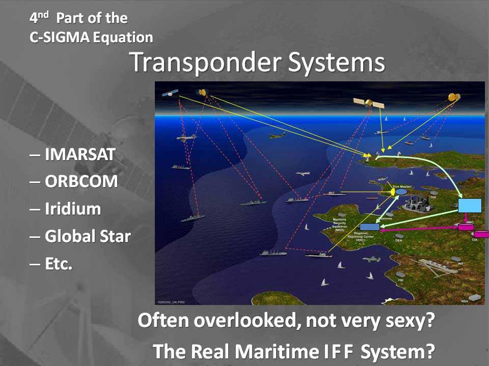
50 C SIGMA Event Timeline A. Commercial Satellites equipped with AIS receivers (S AIS) continuously Detect s all AIS emitters in area of interest. B. Several Commercial Comm Satellites collect all ship positions reported via LRIT, VMS and private systems.
51 C SIGMA Event Timeline 1. Radar Satellite images area of interest on routine pass. 2. Central processing facility correlates contacts detected via RadarSat to S AIS, S VMS and LRIT data. Detects three vessels of interest & 3. Alerts appropriate ground stations to task HR imaging satellite(s) ) to image the areas where the three vessels of interest can next be accessed, based on Traffic Patterns
52 C SIGMA Event Timeline Routine Event 4. All three resulting images are studied for items of interest, anomalous activity. One unit is deemed suspicious 5. MPA is dispatched for a closer look, and Cutter is diverted to intercept, if needed. 6. MPA detects possible illegal activity and maintains track until. 7. Cutter arrives on scene and boards

53

54


55 All of the foregoing begs the question: Initial Steps: 1. Set up International committee? 2.Coordination office at.? ESA? USCG? Canada? US DHS? 3.US coordination led by USCG? Transportation? DHS? State???? Immediate Next Steps

 Identify: Basic System Components Next Steps to Implement")
56 Purpose Achieve consensus: Exploratory Workshop With international and inter agency partners Need to build an unclassified system using available space based (+ Terrestrial) systems To establish a mechanism for Global Maritime Awareness (GMA) Identify: Basic System Components Next Steps to Implement GMA.
57 Delayed
58
59 QUESTIONS?
*For International Stewardship of the Maritime Environment and its Resources. Photo
 *For International Stewardship of the Maritime Environment and its Resources *For Maritime Safety *For Security Photo # Providing Environmental Monitoring* # Increasing Security* # Enabling Safety Efforts*
The Ability of a Small Satellite Constellation to Tip and Cue Other Commercial Assets
 Changing the economics of space The Ability of a Small Satellite Constellation to Tip and Cue Other Commercial Assets Becky Cudzilo - Surrey Satellite US, LLC K.C. Foley - GeoEye, Inc. Chandler Smith -
KONGSBERG SATELLITE SERVICES 2017 Line Steinbakk, Director Programs. Himmel og hav - Ålesund 3. Oktober 2017
 KONGSBERG SATELLITE SERVICES 2017 Line Steinbakk, Director Programs Himmel og hav - Ålesund 3. Oktober 2017 KSAT HQ IN TROMSØ 69N Established in 1967 Kongsberg Satellite Services since 2002 World leading
PMAR Piracy, Maritime Awareness & Risks
 PMAR Piracy, Maritime Awareness & Risks Maritime Situational Awareness for Counter-Piracy European Commission Joint Research Centre 13 June 2012 GeoMaritime, London 1 MSA for counter-piracy study Key elements
Satellite services for maritime security
 Satellite services for ITS-T Sophia Antipolis 6 June 2007 Jean-Pierre Cauzac, CLS - Collecte Localisation Satellites 35 Are the seas becoming more dangerous? IMB report 2006 shows improvement: 239 piracy
Space Based Vessel Detection - Combining Earth Observation and AIS for Maritime surveillance TEXAS V and C-Σ III
 Space Based Vessel Detection - Combining Earth Observation and AIS for Maritime surveillance TEXAS V and C-Σ III Tony Bauna Director, Product and Service Development, Kongsberg Satellite Services, Tromsø,
KONGSBERG. WORLD CLASS through people, technology and dedication WORLD CLASS through people, technology and dedication
 WORLD CLASS through people, technology and dedication WORLD CLASS through people, technology and dedication Skipsdeteksjon fra radarsatellitter SkipSat Richard Hallr Kongsberg Satellite Services AS (KSAT)
KONGSBERG SATELLITE SERVICES Earth Observation for Maritime Operations Current Capabilities and Future Potential
 KONGSBERG SATELLITE SERVICES 2017 Earth Observation for Maritime Operations Current Capabilities and Future Potential Andreas Hay Kaljord Project Manager KSAT HQ IN TROMSØ - 69N WELCOME TO TROMSØ Established
SAR Interferometry Capabilities of Canada's planned SAR Satellite Constellation
 SAR Interferometry Capabilities of Canada's planned SAR Satellite Constellation Dirk Geudtner, Guy Séguin,, Ralph Girard Canadian Space Agency RADARSAT Follow-on Program CSA is in the middle of a Phase
Satellite data for Maritime Operations. Andreas Hay Kaljord Project Manager Energy, Environment & Security
 Satellite data for Maritime Operations Andreas Hay Kaljord Project Manager Energy, Environment & Security Kongsberg Satellite Services (KSAT) World leading provider within our business area Supports 85
satellite based maritime awareness and surveillance Italian Coast Guard Headquarters
 satellite based maritime awareness and surveillance THE ITCG S ACTIVITIES ARE PERFORMED FOR: BY LAW ITALIAN COAST GUARD IS RESPONSIBLE FOR: PERFORMING AND COORDINATING MARITIME SEARCH AND RESCUE OPERATIONS
Affordable space based radar for homeland security
 Changing the economics of space Affordable space based radar for homeland security Adam Baker Brent Abbott Phil Whittaker Rachel Bird Luis Gomes Summary Why Radar? However: Radar data is expensive Users
Remote Sensing Analysis Framework for Maritime Surveillance Application
 Remote Sensing Analysis Framework for Maritime Surveillance Application Olaf Frauenberger, Egbert Schwarz, Sergey Voinov Maritime Security Lab Neustrelitz (DFD) Maritime Big Data Workshop, 9-11 May, La
Abstract. 1. Introduction
 Title: Satellite surveillance for maritime border monitoring Author: H. Greidanus Number: File: GMOSSBordMon1-2.doc Version: 1-2 Project: GMOSS Date: 25 Aug 2004 Distribution: Abstract Present day remote
Utilization of Radar data for Maritime Surveillance
 INDESO Project Utilization of Radar data for Maritime Surveillance DENDY MAHABROR MARINE RESEARCH CENTER INDESO RADAR GROUND STATION RADARSAT-2 AND COSMO-SKYMED BALI INDESO satelit VMS satelite radar vessel
Kongsberg Satellite Services, KSAT
 SvalSat, Earth Station at 78 North Kongsberg Satellite Services, KSAT Making Sense of Space Sigmund Dehli International Sales Manager WORLD CLASS through people, technology and dedication My plan KSAT
Introduction to KOMPSAT
 Introduction to KOMPSAT September, 2016 1 CONTENTS 01 Introduction of SIIS 02 KOMPSAT Constellation 03 New : KOMPSAT-3 50 cm 04 New : KOMPSAT-3A 2 KOMPSAT Constellation KOMPSAT series National space program
School of Rural and Surveying Engineering National Technical University of Athens
 Laboratory of Photogrammetry National Technical University of Athens Combined use of spaceborne optical and SAR data Incompatible data sources or a useful procedure? Charalabos Ioannidis, Dimitra Vassilaki
Canadian Space Agency program update
 Canadian Space Agency program update Briefing to the meeting of the Expert Team on Satellite Systems (ET-SAT-11) Geneva, 4 April 2017 Guennadi Kroupnik Canadian Space Agency RADARSAT-2: CURRENT OPERATIONAL
SAR missions for oceanography at the European Space Agency
 SAR missions for oceanography at the European Space Agency ERS-1, ERS-2, Envisat, Sentinel-1A, Sentinel-1B, ESA 3 rd Party Missions (ALOS) Prepared by ESA teams and ESA supporting companies ESA and SAR
Integrating Spaceborne Sensing with Airborne Maritime Surveillance Patrols
 22nd International Congress on Modelling and Simulation, Hobart, Tasmania, Australia, 3 to 8 December 2017 mssanz.org.au/modsim2017 Integrating Spaceborne Sensing with Airborne Maritime Surveillance Patrols
It is an Interconnected World. Except in the Maritime Domain In 2008 Satellite AIS (S-AIS) Changed All that!
 Changed All that!") It is an Interconnected World Except in the Maritime Domain In 2008 Satellite AIS (S-AIS) Changed All that! Background This brief is the result of that Research, which continues to this day. Makes Regional
It is an Interconnected World Except in the Maritime Domain In 2008 Satellite AIS (S-AIS) Changed All that! Background This brief is the result of that Research, which continues to this day. Makes Regional
Copyright 2016 Raytheon Company. All rights reserved. Customer Success Is Our Mission is a registered trademark of Raytheon Company.
 Make in India Paradigm : Roadmap for a Future Ready Naval Force Session 9: Coastal Surveillance, Response Systems and Platforms Nik Khanna, President, India April 19, 2016 "RAYTHEON PROPRIETARY DATA THIS
ERS/ENVISAT ASAR Data Products and Services
 ERS/ENVISAT ASAR Data Products and Services Andrea Celentano Business Manager celentan@eurimage.com What is Eurimage? Founded in 1989 Current shareholders: Since 1989 Commercial Partner of the European
The Role of RADARSAT-2 for Flood and Agriculture Monitoring
 The Role of RADARSAT-2 for Flood and Agriculture Monitoring Gordon Staples MDA Richmond, BC, CANADA gstaples@mda.ca RESTRICTION ON USE, PUBLICATION OR DISCLOSURE OF PROPRETIARY INFORMATION This document
Government Agency Perspectives & Initiatives Canadian Coast Guard Laurent Tardif, Director, Safe Shipping
 Unclassified Government Agency Perspectives & Initiatives Canadian Coast Guard Laurent Tardif, Director, Safe Shipping Mariner s Workshop January 23, 2019 1 Overview 1 Context 2 Marine Fees 3 4 5 Update
Satellite Technologies for Fisheries Monitoring, Control and Surveillance (MCS)
") JRC IPSC Maritime Affairs 1 Satellite Technologies for Fisheries Monitoring, Control and Surveillance (MCS) Juan Cicuendez, Marlene Alvarez JRC Info Day Madrid, 2 June 2010 IPSC - Institute for the Protection
JRC IPSC Maritime Affairs 1 Satellite Technologies for Fisheries Monitoring, Control and Surveillance (MCS) Juan Cicuendez, Marlene Alvarez JRC Info Day Madrid, 2 June 2010 IPSC - Institute for the Protection
DLR contribution and perspectives for JECAM
 DLR contribution and perspectives for JECAM Dr. Helmut Staudenrausch 1, Dr. Achim Roth 2 1 DLR Space Administration, Earth Observations helmut.staudenrausch@dlr.de 2 DLR, German Remote Sensing Data Center
Cost Effective Control of your Coastal Waters
 Cost Effective Control of your Coastal Waters Olov Fäst SSC Airborne Systems 2013-07-03 SSC: A comprehensive space industry Founded in 1972 ~650 employees (2012) ~100 M turnover (2012) Since the start
RADARSAT-2 Program Update Daniel De Lisle Canadian Space Agency
 RADARSAT-2 Program Update Daniel De Lisle Canadian Space Agency Presentation outline RADARSAT-1 Update RADARSAT-2 Mission description Mission Objectives System Characteristics Data Commercialization/Allocation
TerraSAR-X Applications Guide
 TerraSAR-X Applications Guide Extract: Maritime Monitoring: Ship Detection April 2015 Airbus Defence and Space Geo-Intelligence Programme Line Maritime Monitoring: Ship Detection Issue Maritime security
The RCAF S&T program and the All Domain
 The RCAF S&T program and the All Domain Situational Awareness (ADSA) S&T Program) CADSI AIR FORCE Martin McKinnon Director S&T Air (DSTA-3) Assistant Deputy Minister, Science and Technology Department
Satellite SAR ship detections from PMAR in support of Cutlass Express
 Satellite SAR ship detections from PMAR in support of Cutlass Express Harm Greidanus, Marlene Alvarez, Tulay Cokacar, Andrea Pesaresi, Carlos Santamaria, Vladimir Kyovtorov EUR 25140 EN - 2011 The mission
A CONCEPT FOR NATURAL GAS TRANSMISSION PIPELINE MONITORING BASED ON NEW HIGH-RESOLUTION REMOTE SENSING TECHNOLOGIES
 A CONCEPT FOR NATURAL GAS TRANSMISSION PIPELINE MONITORING BASED ON NEW HIGH-RESOLUTION REMOTE SENSING TECHNOLOGIES Werner Zirnig - Ruhrgas Aktiengesellschaft Dieter Hausamann - DLR German Aerospace Center
Downloaded by on April 16, DOI: /
 Polar Epsilon: Joint Space-Based Wide Area Surveillance and Support Project LCdr Robert Quinn Project Director Polar Epsilon Directorate of Space Development Phone: +1(613)945-5212 Quinn.rj2@forces.gc.ca
RADAR SATELLITES AND MARITIME DOMAIN AWARENESS
 RADAR SATELLITES AND MARITIME DOMAIN AWARENESS J.K.E. Tunaley Corporation, 114 Margaret Anne Drive, Ottawa, Ontario K0A 1L0 (613) 839-7943 Report Documentation Page Form Approved OMB No. 0704-0188 Public
KOMPSAT Constellation. November 2012 Satrec Initiative
 KOMPSAT Constellation November 2012 Satrec Initiative KOMPSAT Constellation KOMPSAT National program Developed and operated by KARI (Korea Aerospace Research Institute) Dual use : Government & commercial
SAR Imagery: Airborne or Spaceborne? Presenter: M. Lorraine Tighe PhD
 SAR Imagery: Airborne or Spaceborne? Presenter: M. Lorraine Tighe PhD Introduction The geospatial community has seen a plethora of spaceborne SAR imagery systems where there are now extensive archives
Change Detection using SAR Data
 White Paper Change Detection using SAR Data John Wessels: Senior Scientist PCI Geomatics Change Detection using SAR Data The ability to identify and measure significant changes in target scattering and/or
Demonstrator of a Data Processing Centre (DPC) for satellite-based AIS services
 for satellite-based AIS services") Page 1 Demonstrator of a Data Processing Centre (DPC) for satellite-based AIS services 19/20 April 2012 gfabritius@cls.fr Overview of the presentation Page 2 Introducing CLS Introducing AIS / SAT-AIS Scope
Page 1 Demonstrator of a Data Processing Centre (DPC) for satellite-based AIS services 19/20 April 2012 gfabritius@cls.fr Overview of the presentation Page 2 Introducing CLS Introducing AIS / SAT-AIS Scope
COSMO-SkyMed Mission Status Presented by Fabrizio BATTAZZA (ASI)
") COSMO-SkyMed Mission Status Presented by Fabrizio BATTAZZA (ASI) COSMO-1 & COSMO-2 LAUNCHES FIRST SATELLITE OF THE CONSTELLATION SUCCESSFULLY LAUNCHED 08 June 2007 03:35 (GMT) Vandenberg U.S.A. Air Force
COSMO-SkyMed Mission Status Presented by Fabrizio BATTAZZA (ASI) COSMO-1 & COSMO-2 LAUNCHES FIRST SATELLITE OF THE CONSTELLATION SUCCESSFULLY LAUNCHED 08 June 2007 03:35 (GMT) Vandenberg U.S.A. Air Force
Integration of AIS functionalities
 Integration of AIS functionalities by John O. Klepsvik FARGIS 05 March 01, 2005 WORLD CLASS through people, technology and dedication WORLD CLASS through people, technology and dedication KONGSBERG March
WHAT IS NEXT IN EARTH OBSERVATION. SkyMed Mission
 WHAT IS NEXT IN EARTH OBSERVATION COSMO-SkyMed SkyMed Mission Paolo Ammendola Italian Space Agency Florence, Sept. 19, 2001 ammendola@asi asi.it THE NEEDS Market studies indicate that the value of the
Targeting a Safer World
 Targeting a Safer World INTRODUCTION Accipiter Radar is a global provider of high performance radar surveillance solutions built upon its patented Radar Intelligence Network (RIN) Platform Technology.
Targeting a Safer World. Public Safety & Security
 Targeting a Safer World Public Safety & Security WORLD S MOST EFFECTIVE AND AFFORDABLE WIDE-AREA SITUATIONAL AWARENESS Accipiter provides the world s most effective and affordable wide-area situational
Copernicus Introduction Lisbon, Portugal 13 th & 14 th February 2014
 Copernicus Introduction Lisbon, Portugal 13 th & 14 th February 2014 Contents Introduction GMES Copernicus Six thematic areas Infrastructure Space data An introduction to Remote Sensing In-situ data Applications
Innovative Maritime Surveillance Capabilities. Pre-operational Services for Highly. Development of. Maria Angelucci, e-geos
 Development of Pre-operational Services for Highly Innovative Maritime Surveillance Capabilities ASI Workshop - 7 th Framework Program Rome, June 27 th, 2012 Maria Angelucci, e-geos 1 Figures Start date:
CSA Report on Earth Observation
 CSA Report on Earth Observation Presented at Shanghai, China May 13 17, 2013 Dr. Satish K. Srivastava WGCV Chair & CSA Member of WGCV Page 1 RADARSAT-1 Program Status Since 22:30 UTC March 29, 2013, it
The ERS contribution to Oil Spill Monitoring - From R&D towards an operational service -
 The ERS contribution to Oil Spill Monitoring - From R&D towards an operational service - J.P. Pedersen, T.Bauna, L.G. Seljelv, L. Steinbakk, R.T.Enoksen Tromsø Satellite Station, N-9291 Tromsø, Norway
RADARSAT-2 Modes and Applications
 RADARSAT-2 Modes and Applications Gordon Staples MDA Geospatial Services February 6, 2017 1 Introduction RADARSAT-2 was developed to meet operational needs via a versatile space segment and a responsive
NovaSAR-S - Bringing Radar Capability to the Disaster Monitoring Constellation
 Changing the economics of space NovaSAR-S - Bringing Radar Capability to the Disaster Monitoring Constellation SSTL: Philip Davies, Phil Whittaker, Rachel Bird, Luis Gomes, Ben Stern, Prof Sir Martin Sweeting
Coastal Surveillance. SCANTER Radar Solutions
 Coastal Surveillance SCANTER Radar Solutions Protecting Your Coastlines and Maritime Domain We provide radar coverage of the coastline to detect and track all types of surface vessels and air targets.
Port Security and Technology - the U.S. Perspective. Michael S. Bruno Stevens Institute of Technology March 14, 2012
 Port Security and Technology - the U.S. Perspective Michael S. Bruno Stevens Institute of Technology March 14, 2012 CSR A Department of Homeland Security National Center of Excellence for Port Security
Graham Stickler Esri Ocean GIS Forum, Redlands, CA, 5-7 November 2013
 Graham Stickler Esri Ocean GIS Forum, Redlands, CA, 5-7 November 2013 Imagine.. A world with no horizons Coastal Coverage Space View Satellite Constellation 6 satellite polar orbiting + 1 equatorial constellation
Development of Microsatellite to Detect Illegal Fishing MS-SAT
 Development of Microsatellite to Detect Illegal Fishing MS-SAT Ernest S. C. P. Bintang A.S.W.A.M. Department of Aerospace Engineering Faculty of Mechanical and Aerospace Engineering Institut Teknologi
EMSA Additional Dataset Status 31 st March 2015
 EMSA Additional Dataset Status 31 st March 2015 DWH_MG2_EMSA_ADD_001a: _rush_optical_hr1... 2 DWH_MG2_EMSA_ADD_001b: _rush_optical_hr2... 3 DWH_MG2_EMSA_ADD_002a: ew acquisition_rush_optical_hr1... 4 DWH_MG2_EMSA_ADD_002b:
Synthetic Aperture Radar for Rapid Flood Extent Mapping
 National Aeronautics and Space Administration ARSET Applied Remote Sensing Training http://arset.gsfc.nasa.gov @NASAARSET Synthetic Aperture Radar for Rapid Flood Extent Mapping Sang-Ho Yun ARIA Team Jet
7.7 TerraSAR-X & TanDEM-X
 7.7 TerraSAR-X & TanDEM-X Two Innovative Remote Sensing Stars for space-borne Earth Observation Vorlesung Wolfgang Keydel Microwaves and Radar Institute, German Aerospace Research Center (DLR), D-82230
Observing Dry-Fallen Intertidal Flats in the German Bight Using ALOS PALSAR Together With Other Remote Sensing Sensors
 Observing Dry-Fallen Intertidal Flats in the German Bight Using ALOS PALSAR Together With Other Remote Sensing Sensors Martin Gade, Institut für Meereskunde & Kerstin Stelzer Brockmann Consult Outline
MULTI-CHANNEL SAR EXPERIMENTS FROM THE SPACE AND FROM GROUND: POTENTIAL EVOLUTION OF PRESENT GENERATION SPACEBORNE SAR
 3 nd International Workshop on Science and Applications of SAR Polarimetry and Polarimetric Interferometry POLinSAR 2007 January 25, 2007 ESA/ESRIN Frascati, Italy MULTI-CHANNEL SAR EXPERIMENTS FROM THE
COSMO-SkyMed Mission Status Presented by Giovanni VALENTINI (ASI)
") COSMO-SkyMed Mission Status Presented by Giovanni VALENTINI (ASI) FIRST SATELLITE FIRST SATELLITE OF THE CONSTELLATION SUCCESSFULLY LAUNCHED 08 June 2007 03:35 (GMT) Vandenberg U.S.A. Air Force Base SECOND
COSMO-SkyMed Mission Status Presented by Giovanni VALENTINI (ASI) FIRST SATELLITE FIRST SATELLITE OF THE CONSTELLATION SUCCESSFULLY LAUNCHED 08 June 2007 03:35 (GMT) Vandenberg U.S.A. Air Force Base SECOND
Enhanced Maritime Traffic Picture for the Canadian Arctic
 Enhanced Maritime Traffic Picture for the Canadian Arctic Giulia Battistello*, Martin Ulmke*, Camilla Mohrdieck** (*) Fraunhofer FKIE - Sensor Data and Information Fusion Department - Wachtberg, Germany
COPERNICUS COLLABORATIVE GROUND SEGMENT TO SUPPORT MARITIME SITUATIONAL AWARENESS
 COPERNICUS COLLABORATIVE GROUND SEGMENT TO SUPPORT MARITIME SITUATIONAL AWARENESS D. Krause*, E. Schwarz, H. Damerow, German Aerospace Center (DLR), German Remote Sensing Data Center (DFD), Kalkhorstweg
Earth Observation and Sensing Technologies: a focus on Radar Imaging Developments. Riccardo Lanari
 Earth Observation and Sensing Technologies: a focus on Radar Imaging Developments Riccardo Lanari Institute for Electromagnetic Sensing of the Environment (IREA) National Research Council of Italy (CNR)
Trusted for Life TM. USCG AIS Mandate. 3 rd December 10:30 am - 11:15 am
 Trusted for Life TM USCG AIS Mandate 3 rd December 10:30 am - 11:15 am The AIS Mandate McMurdo Stand 2335 CEO McMurdo UK McMurdo By the Numbers 25% Percentage of world s 406MHz beacons manufactured by
Warren Cartwright, Product Manager MDA Geospatial Services, Canada
 Advanced InSAR Techniques for Urban Infrastructure Monitoring Warren Cartwright, Product Manager MDA Geospatial Services, Canada www.mdacorporation.com RESTRICTION ON USE, PUBLICATION OR DISCLOSURE OF
Sentinel-1 System Overview
 Sentinel-1 System Overview Dirk Geudtner, Rámon Torres, Paul Snoeij, Malcolm Davidson European Space Agency, ESTEC Global Monitoring for Environment and Security (GMES) EU-led program aiming at providing
Disruptive technologies and future trends of small satellites
 2016 SSTL Disruptive technologies and future trends of small satellites Luis Gomes Director of EO & science Surrey Satellite Technology Limited Radio Communication June 1978 2016 SSTL The DMC and RapidEye
Co-ReSyF RA lecture: Vessel detection and oil spill detection
 This project has received funding from the European Union s Horizon 2020 Research and Innovation Programme under grant agreement no 687289 Co-ReSyF RA lecture: Vessel detection and oil spill detection
Prague - 29 June 2009 A. COLETTA COLETTA. COSMO-SkyMed Mission: COSMO-SkyMed Mission. Application and Data Access
 A. A. COLETTA COLETTA COSMO-SkyMed COSMO-SkyMed Mission Mission Manager Manager ITALIAN ITALIAN SPACE SPACE AGENCY AGENCY COSMO-SkyMed Mission: Application and Data Access The COSMO-SkyMed PROGRAMME The
Collaborative use of SAR and AIS data from NovaSAR-S for Maritime Surveillance
 Collaborative use of SAR and AIS data from NovaSAR-S for Maritime Surveillance Lotfi Achiri, University of Surrey, Surrey Space Centre, l.achiri@surrey.ac.uk, UK Raffaella Guida, University of Surrey,
The Sentinel-1 Constellation
 The Sentinel-1 Constellation Evert Attema, Sentinel-1 Mission & System Manager AGRISAR and EAGLE Campaigns Final Workshop 15-16 October 2007 ESA/ESTECNoordwijk, The Netherlands Sentinel-1 Programme Sentinel-1
Radio Frequency Sensing from Space
 Radio Frequency Sensing from Space Edoardo Marelli ITU-R WP 7C Chairman ITU-R Seminar Manta (Ecuador) 20 September 2012 Why observing the Earth from space? Satellites orbiting around the Earth offer an
Table Satellites used for observations by members of the Disaster Charter and others (except Daichi)
") 2.1.4 Cooperation with from overseas institutions JAXA asked Sentinel Asia and, on behalf of the Cabinet Office, the Disaster Charter to carry out emergency observations immediately after the earthquake
2.1.4 Cooperation with from overseas institutions JAXA asked Sentinel Asia and, on behalf of the Cabinet Office, the Disaster Charter to carry out emergency observations immediately after the earthquake
Multi Sensor Data Fusion
 Multi Sensor Data Fusion for improved maritime traffic monitoring in the Canadian Arctic Giulia Battistello*, Martin Ulmke*, Javier Gonzalez*, Camilla Mohrdieck** (*) Fraunhofer FKIE Sensor Data and Information
Operational Space-Based Imaging Systems
 Operational Space-Based Imaging Systems R E M O T E S E N S I N G & G E O S PAT I A L A N A LY S I S L A B D O I : 2 0 A U G U S T, 2 0 1 6 Earth Observation Systems U.S. or foreign government systems
Earth Observation Opportunities to Enhance Maritime Safety
 http://www.transnav.eu the International Journal on Marine Navigation and Safety of Sea Transportation Volume 11 Number 4 December 2017 DOI: 10.12716/1001.11.04.17 Earth Observation Opportunities to Enhance
The Radar Ortho Suite is an add-on to Geomatica. It requires Geomatica Core or Geomatica Prime as a pre-requisite.
 Technical Specifications Radar Ortho Suite The Radar Ortho Suite includes rigorous and rational function models developed to compensate for distortions and produce orthorectified radar images. Distortions
A Space-Based Solution for Illegal, Unregulated & Unreported Fishing. Emmanouil Detsis, International Space University
 Project Catch A Space-Based Solution for Illegal, Unregulated & Unreported Fishing Emmanouil Detsis, International Space University Project Catch COPUOS Presentation Team Project Oceans International Intercultural
Canada s. Third. Generation. High Frequency. Surface Wave. Radar System
 Canada s Third Generation High Frequency Surface Wave Radar System by Peter Moo, Tony Ponsford, David DiFilippo, Rick McKerracher, Nathan Kashyap, and Yannick Allard Introduction The granting of coastal
All rights reserved. ENVI, IDL and Jagwire are trademarks of Exelis, Inc. All other marks are the property of their respective owners.
 SAR Analysis Made Easy with SARscape 5.1 All rights reserved. ENVI, IDL and Jagwire are trademarks of Exelis, Inc. All other marks are the property of their respective owners. 2014, Exelis Visual Information
TanDEM-X: Mission Status & Scientific Contribution
 TanDEM-X: Mission Status & Scientific Contribution Irena Hajnsek 1/2, Gerhard Krieger 1, Kostas Papathanassiou 1, Stefan Baumgartner 1, Marc Rodriguez-Cassola 1, Pau Prats 1, Maria Sanjuan Ferrer 1, Florian
Introduction to Radar
 National Aeronautics and Space Administration ARSET Applied Remote Sensing Training http://arset.gsfc.nasa.gov @NASAARSET Introduction to Radar Jul. 16, 2016 www.nasa.gov Objective The objective of this
Oil & Gas / EO Service Industry Workshop September 2010
 Oil & Gas / EO Service Industry Workshop 14-15 September 2010 Stephen Coulson, Philppe Bally, Gordon Campbell, Ben Koetz, Pierre-Philippe Mathieu, Ola Grabak, (ESA) Ana Belen Ruescas (Serco) Introduction
High resolution ground deformations monitoring by COSMO-SkyMed PSP SAR interferometry
 High resolution ground deformations monitoring by COSMO-SkyMed PSP SAR interferometry Mario Costantini e-geos - an ASI/Telespazio Company, Rome, Italy mario.costantini@e-geos.it Summary COSMO-SkyMed satellite
Satellite Imagery Characteristics, Uses and Delivery to GIS Systems. Wayne Middleton April 2014
 Satellite Imagery Characteristics, Uses and Delivery to GIS Systems Wayne Middleton April 2014 About Geoimage Founded in Brisbane 1988 Leading Independent company Specialists in satellite imagery and geospatial
The Convair 580 SAR Facility Recent Activities and Future Opportunities
 The Convair 580 SAR Facility Recent Activities and Future Opportunities Dr. Carl E. Brown Emergencies Science and Technology Section Environment Canada Ottawa, Ontario ESTS Airborne Remote Sensing DC-3,
Regional and Inter-Regional Seminar and Workshop on Search and Rescue
 Regional and Inter-Regional Seminar and Workshop on Search and Rescue Mahe, Seychelles 19-22 July 2016 1 Agenda Aireon Introduction Space-Based ADS-B Overview Aireon System Deployment Status Aireon ALERT
Mission Solution 100
 Mission Solution 100 Standard configuration for littoral security Member of the Thales Mission Solution family Standard configuration of integrated sensors, effectors, CMS, communication system and navigation
COMMUNICATIONS FOR MARITIME SAFETY AND EFFICIENCY. Francis Zachariae, Secretary-General, IALA
 COMMUNICATIONS FOR MARITIME SAFETY AND EFFICIENCY Francis Zachariae, Secretary-General, IALA IALA and its Purpose Non profit, international technical association established in 1957 Two Goals aimed at
Using satellite technology to monitor illegal, unreported, and unregulated (IUU) fishing
 fishing") Using satellite technology to monitor illegal, unreported, and unregulated (IUU) fishing Mark Richardson The Pew Charitable Trusts Blue Planet Symposium, June 2, 2017 The global threat of IUU fishing Illegal,
Using satellite technology to monitor illegal, unreported, and unregulated (IUU) fishing Mark Richardson The Pew Charitable Trusts Blue Planet Symposium, June 2, 2017 The global threat of IUU fishing Illegal,
The use of satellite images to forecast agricultural
 The use of satellite images to forecast agricultural Luxembourg, 12.03.2014 r. Tomasz Milewski NUTS for Poland: NUTS 1 macro-regions (grup of province, voivodships) (6), NUTS 2 - regions (province,
ICAO Inter-regional SAR Workshop 2016
 ICAO Inter-regional SAR Workshop 2016 Global Aeronautical Distress and Safety System (GADSS) - Implications for Search And Rescue Services Dave Edwards U.S. Coast Guard Chairman, International Civil Aviation
Geospatial Vision and Policies Korean Industry View 26 November, 2014 SI Imaging Services
 Geospatial Vision and Policies Korean Industry View 26 November, 2014 SI Imaging Services Distribution Limitation, SI Imaging Services Proprietary Data : The data contained in this document, without the
Introduction Objective and Scope p. 1 Generic Requirements p. 2 Basic Requirements p. 3 Surveillance System p. 3 Content of the Book p.
 Preface p. xi Acknowledgments p. xvii Introduction Objective and Scope p. 1 Generic Requirements p. 2 Basic Requirements p. 3 Surveillance System p. 3 Content of the Book p. 4 References p. 6 Maritime
An Introduction to INDUSTRY PARTNERS 25/05/2017. Military Army & Air Force. Government Defense & Rescue. Aviation Maritime Military. Other.
 An Introduction to 1 INDUSTRY PARTNERS Aviation Maritime Military Coast Guard & Navy Military Army & Air Force Government Defense & Rescue Other Commercial Commercial/Workboat Navy Air Force SAR Agencies
COSMO-skymed, TerraSAR-X, and RADARSAT-2 geolocation accuracy after compensation for earth-system effects
 Zurich Open Repository and Archive University of Zurich Main Library Strickhofstrasse 9 CH-857 Zurich www.zora.uzh.ch Year: COSMO-skymed, TerraSAR-X, and RADARSAT- geolocation accuracy after compensation
CJ Jagadeesha,NDRF-IEI, Bangalore RM Vasagam,Chairman Aerospace Division Board,IEI LVM Reddy,Vice-President,IEI
 CJ Jagadeesha,NDRF-IEI, Bangalore RM Vasagam,Chairman Aerospace Division Board,IEI LVM Reddy,Vice-President,IEI D] Geo informatics for assessing EWS in watersheds E] DSS for EW communication and policy
The Future in Marine Radio Communication GMDSS. Department of Transportation United States Coast Guard
 The Future in Marine Radio Communication GMDSS Department of Transportation United States Coast Guard Do you use a Maritime Radio System? If so, the new Global Maritime Distress and Safety System (GMDSS)
NEREIDS: New concepts in maritime surveillance for consolidating operational developments
 SEASAR12 WORKSHOP, TROMSO, 06-12 NEREIDS: New concepts in maritime surveillance for consolidating operational developments Property of GMV All rights reserved SUMMARY NEREIDS PROJECT NEREIDS CHALLENGES