COSMO-SkyMed Mission Status Presented by Fabrizio BATTAZZA (ASI)
|
|
|
- Clinton Harrington
- 5 years ago
- Views:
Transcription


1 COSMO-SkyMed Mission Status Presented by Fabrizio BATTAZZA (ASI)


2 COSMO-1 & COSMO-2 LAUNCHES FIRST SATELLITE OF THE CONSTELLATION SUCCESSFULLY LAUNCHED 08 June :35 (GMT) Vandenberg U.S.A. Air Force Base SECOND SATELLITE OF THE CONSTELLATION SUCCESSFULLY LAUNCHED 09 December :31 (GMT) Vandenberg U.S.A. Air Force Base
3 THIRD SATELLITE THIRD SATELLITE OF THE CONSTELLATION WILL BE LAUNCHED IN SEPTEMBER 2008
4 WIDE APPLICATION RANGE IN A DUAL SCENARIO OCEAN AND ICE MONITORING MONITORING AND MANAGEMENT OF COASTLINES AND INLAND WATERS RISKS MONITORING AND PREVENTION - MANAGEMENT OF EMERGENCIES FLOODS OIL SPILL EARTHQUAKES LANDSLIDES VOLCANOES SEISMIC RISK FIRES TECHNICAL CARTOGRAPHY - URBAN PLANNING MONITORING AND MANAGEMENT OF FORESTRY AND AGRICULTURAL RESOURCES DEFENCE APPLICATIONS SCIENCE APPLICATIONS
5 CURRENT STATUS WHERE ARE WE NOW? CLOSE TO THE COMPLETION OF THE 1st SATELLITE COMMISSIONING PHASE HUNDREDS OF IMAGES ACQUIRED RESULTS BEGINNING EVALUATION OF THE OPERATION QUALIFICATION PHASE COMPLETION OF THE 2nd SATELLITE COMMISSIONING PHASE
6 COSMO-SkyMed TIME SCHEDULE 3rd Satellite PLANNED TO BE LAUNCHED: September 2008 PROCESSING AND DISSEMINATION OF PRODUCTS 4 OPERATIVE SATELLITES SABRINA and COSMO-SkyMed SkyMed 2nd GENERATION....

7 SPACE SEGMENT Web Site address 4 SATELLITES 90 Separ. HEIGHT Km INCLINATION 97.8 ORBIT PERIOD ~ 97 m DAWN/DUSK SSO Frozen Orbit LTAN 6 a.m.
 AVERAGE REVISIT TIME AT")
 AVERAGE REVISIT TIME AT ~ 2-5 h MAX")
8 REVISIT TIME FULL CONSTELLATION RL/LL EXTENDED INCIDENCE ANGLE RANGE FULL CONSTELLATION (extended, R&L) AVERAGE REVISIT TIME AT POLAR LAT. ~ 1-3 h NOW (extended, R&L) AVERAGE REVISIT TIME AT POLAR LAT. ~ 2-5 h MAX REVISIT TIME ~ 12 h MAX REVISIT TIME ~ 37 h
9 RESPONSE TIME RESPONSE TIME (from the deposit of the request up to the product delivery ) SYSTEM OPERATIVE MODES Maximum Values VERY URGENT 4 SATELLITES 18 h NOW 47 h CRISIS 36 h 64 h ROUTINE 72 h 82 h
10 MULTI-MODE ACQUISITION CAPABILITY NARROW FIELD SPOTLIGHT 1 m Resol. (10 km X 10 km) HIMAGE 3x3 5x5 m Resol. (40 km X 40 km) WIDE FIELD PINGPONG 15x15 m Resol. (30 km X 30 km) WIDEREGION 30X30 m Res. (100 km X 100 km) HUGEREGION 100X100 m Res. (200 km X 200 km)
")
11 ACCESSA AREA ELECTRONIC BEAM STEERING CAPABILITY Nominal Incidence Angle Range Flight Direction Instrument FOV Instrument LOS Incidence Angle Capability Nominal Direction 34 SSP Extended Incidence Angle Range 20-59,5 Heel Toe Right & Left Looking Capability Swath Access Area EXTENDED ACCESS AREA ~ 630 Km (Single Side looking)

12 INTERFEROMETRIC MISSIONS CURRENT CONSTELLATION DECORRELATION TIME = 8 DAYS The two satellites are equi-phased (180 ) TANDEM INTERFEROMETRY MISSION SAME GROUND TRACK The two satellites are separated both in phase and in LTAN, with two different Z ECI orbital planes with slightly different nodes, such to obtain Leader the "same" ground-track. It implies that the Follower distance between ground tracks is not null, but adjusted to Nominal the interferometric baseline (in frozen orbit the order of hundreds of meters) Configuration Best compromise preferred among for safety decorrelation reasonstime, and satellite safe commandability distance X ECI delta-v aspects cost Ω AN AN Y ECI 151 km along track 0.08 deg. plane separation 20 separation
13 IMAGING CAPABILITY EACH SAR SATELLITE CAN ACQUIRE UP TO 450 IMAGES/DAY 1800 IMAGES / DAY 1500 WIDE FIELD 300 NARROW FIELD NOW 900 IMAGES / DAY 750 WIDE FIELD 150 NARROW FIELD 200 PRODUCTS / DAY
14 IEM INTEROPERABILITY EXPANDABILITY MULTI-SENSORIALITY COSMO-SkyMed SYSTEM UPGRADING CAPABILITY ARGENTINEAN PARTNER FRENCH PARTNER CIVILIAN DOMAIN C-UGS CIVILIAN PARTNER #3 CIVILIAN PARTNER #5 CIVILIAN PARTNER #4


15 INTERNATIONAL COOPERATIONS CURRENT COOPERATIONS At the time being, COSMO-SkyMed System is envisaged to manage the following external Sensor Data: In the frame of ITALY-FRANCE EO COOPERATION: o ORFEO FEDERATE SYSTEM WITH THE FRENCH OPTICAL CONSTELLATION PLEIADES In the frame of ITALY-ARGENTINE EO COOPERATION: o SIASGE OPERATIONALLY COORDINATED SYSTEM WITH THE ARGENTINEAN L-BAND L SAR CONSTELLATION SAOCOM
16 PRODUCTS/DATA EXPLOITATION INSTITUTIONAL/SCIENTIFIC AND COMMERCIAL CSK DATA EXPLOITATION ASI supports the SCIENTIFIC and INSTITUTIONAL data exploitation e-geos e-geos supports the COMMERCIAL data exploitation


17 DATA POLICY DATA POLICY Due to the intrinsic system duality nature and to the national and international co-operations, access and use of COSMO-SkyMed system and data are ruled by a specific regulation for data distribution. ASI has the main goal of ensuring the availability of data to national and international civil users. Issued a Document concerning National Data Policy & Resource Sharing
18 DATA POLICY USER CLASSES a) SYSTEM OWNERS: ASI and Italian Ministry of Defence b) INTERNATIONAL PARTNERS: Defined on the basis of agreements relative to the data/products utilisation c) NATIONAL INSTITUTIONAL USERS: National Institutional Administration for the data/products utilisation d) PRIVILEGED USERS: National and International, defined on the basis of specific agreements for the data/products utilisation e) GENERIC USERS: All the other users.
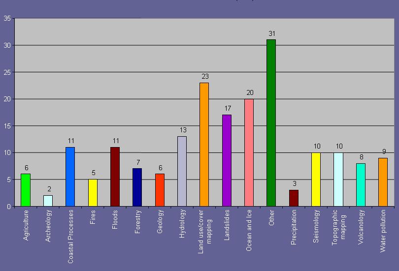
19 BACKGROUND MISSION The The Background Mission Mission (BM) (BM) of of a remote remote sensing sensing system system can can be be roughly defined defined as as the the plan plan to to be be implemented at at the the lowest lowest level level of of priority. (i.e. (i.e. when when no no further further activity activity --so so called called foreground activity activity --is is defined) Development of mission objectives COSMO-SkyMed SkyMed mission objectives cover the following primary fields: Risk Management Applications (the guideline field) Cartography and planning applications Agriculture Forest Hydrology Geology Marine domain Archaeology Inputs from Scientists (e.g. already approved Announcement of Opportunity, IPY?) Institutional Users Commercial users
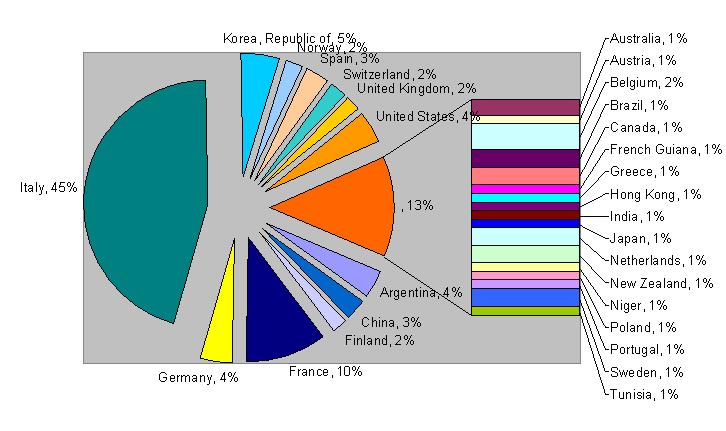
20 COSMO-SkyMed ANNOUNCEMENT OF OPPORTUNITY First COSMO-SkyMed Announcement of Opportunity The project proposals cover the exploitation of COSMO- SkyMed Products for: The First CSK Announcement of Opportunity highlighted a wide Scientific interest Research of the and international Application Development community on the COSMO-SkyMed COSMO-SkyMed Mission Geophysical products (Level 2) algorithm development and validation ~200 project proposals Demonstration of COSMO-SkyMed capabilities in thematic domains of GMES service elements and GEO Program New Ideas for System Exploitation
21 COSMO-SkyMed ANNOUNCEMENT OF OPPORTUNITY
22 COSMO-SkyMed ANNOUNCEMENT OF OPPORTUNITY Web Site address Announcement and opening web for submission of proposals Deadline for submissions Deadline for evaluations AO projects start (products delivery) Second CSK AO at the beginning of 2009 AO projects completion, final reports T0 (20th of May 2007) T0 + 4 months (15 Sept. 2007) T m (end of May 2008) T m (Aug. 2008) T m (July 2010)
COSMO-SkyMed Mission Status Presented by Giovanni VALENTINI (ASI)
") COSMO-SkyMed Mission Status Presented by Giovanni VALENTINI (ASI) FIRST SATELLITE FIRST SATELLITE OF THE CONSTELLATION SUCCESSFULLY LAUNCHED 08 June 2007 03:35 (GMT) Vandenberg U.S.A. Air Force Base SECOND
COSMO-SkyMed Mission Status Presented by Giovanni VALENTINI (ASI) FIRST SATELLITE FIRST SATELLITE OF THE CONSTELLATION SUCCESSFULLY LAUNCHED 08 June 2007 03:35 (GMT) Vandenberg U.S.A. Air Force Base SECOND
Prague - 29 June 2009 A. COLETTA COLETTA. COSMO-SkyMed Mission: COSMO-SkyMed Mission. Application and Data Access
 A. A. COLETTA COLETTA COSMO-SkyMed COSMO-SkyMed Mission Mission Manager Manager ITALIAN ITALIAN SPACE SPACE AGENCY AGENCY COSMO-SkyMed Mission: Application and Data Access The COSMO-SkyMed PROGRAMME The
WHAT IS NEXT IN EARTH OBSERVATION. SkyMed Mission
 WHAT IS NEXT IN EARTH OBSERVATION COSMO-SkyMed SkyMed Mission Paolo Ammendola Italian Space Agency Florence, Sept. 19, 2001 ammendola@asi asi.it THE NEEDS Market studies indicate that the value of the
High resolution ground deformations monitoring by COSMO-SkyMed PSP SAR interferometry
 High resolution ground deformations monitoring by COSMO-SkyMed PSP SAR interferometry Mario Costantini e-geos - an ASI/Telespazio Company, Rome, Italy mario.costantini@e-geos.it Summary COSMO-SkyMed satellite
School of Rural and Surveying Engineering National Technical University of Athens
 Laboratory of Photogrammetry National Technical University of Athens Combined use of spaceborne optical and SAR data Incompatible data sources or a useful procedure? Charalabos Ioannidis, Dimitra Vassilaki
Earth Observation and Sensing Technologies: a focus on Radar Imaging Developments. Riccardo Lanari
 Earth Observation and Sensing Technologies: a focus on Radar Imaging Developments Riccardo Lanari Institute for Electromagnetic Sensing of the Environment (IREA) National Research Council of Italy (CNR)
KONGSBERG SATELLITE SERVICES Earth Observation for Maritime Operations Current Capabilities and Future Potential
 KONGSBERG SATELLITE SERVICES 2017 Earth Observation for Maritime Operations Current Capabilities and Future Potential Andreas Hay Kaljord Project Manager KSAT HQ IN TROMSØ - 69N WELCOME TO TROMSØ Established
GMES DA COPERNICUS
 2014 Airbus Defence and Space All rights reserved. The reproduction, distribution and utilization of this document as well as the communication of its contents to others without express authorization is
For application: Benoit BOISSIN DSP/OT. Redacted by: Hélène de Boissezon -DCT/SI/AP
 Reference: DSP/OT 06-9042 Redacted by: Hélène de Boissezon -DCT/SI/AP For application: / Benoit BOISSIN DSP/OT Siège: 2 place Maurice Quentin -75039 Paris cedex 01 -Tél. : 33 (0)1 44 76 75 00- www.cnes.fr
The exploitation of the COSMO-SkyMed Interoperability, Expandability, Multimission-Multisensor capabilities for the SIASGE System of Systems
 The exploitation of the COSMO-SkyMed Interoperability, Expandability, Multimission-Multisensor capabilities for the SIASGE System of Systems Luca Fasano Italian Space Agency Rome, Italy luca.fasano@asi.it
NovaSAR-S - Bringing Radar Capability to the Disaster Monitoring Constellation
 Changing the economics of space NovaSAR-S - Bringing Radar Capability to the Disaster Monitoring Constellation SSTL: Philip Davies, Phil Whittaker, Rachel Bird, Luis Gomes, Ben Stern, Prof Sir Martin Sweeting
KOMPSAT Constellation. November 2012 Satrec Initiative
 KOMPSAT Constellation November 2012 Satrec Initiative KOMPSAT Constellation KOMPSAT National program Developed and operated by KARI (Korea Aerospace Research Institute) Dual use : Government & commercial
Sentinel-1 Overview. Dr. Andrea Minchella
 Dr. Andrea Minchella 21-22/01/2016 ESA SNAP-Sentinel-1 Training Course Satellite Applications Catapult - Electron Building, Harwell, Oxfordshire Contents Sentinel-1 Mission Sentinel-1 SAR Modes Sentinel-1
Drafting Committee for the Asia Pacific Plan of Action for Space Applications for Sustainable Development ( ) Republic of Korea
 Republic of Korea") Drafting Committee for the Asia Pacific Plan of Action for Space Applications for Sustainable Development (2018 2030) Republic of Korea Bangkok, Thailand 31 May 1 June 2018 김 1 KARI Introduction Government
Drafting Committee for the Asia Pacific Plan of Action for Space Applications for Sustainable Development (2018 2030) Republic of Korea Bangkok, Thailand 31 May 1 June 2018 김 1 KARI Introduction Government
SAR Interferometry Capabilities of Canada's planned SAR Satellite Constellation
 SAR Interferometry Capabilities of Canada's planned SAR Satellite Constellation Dirk Geudtner, Guy Séguin,, Ralph Girard Canadian Space Agency RADARSAT Follow-on Program CSA is in the middle of a Phase
SAR missions for oceanography at the European Space Agency
 SAR missions for oceanography at the European Space Agency ERS-1, ERS-2, Envisat, Sentinel-1A, Sentinel-1B, ESA 3 rd Party Missions (ALOS) Prepared by ESA teams and ESA supporting companies ESA and SAR
Introduction to KOMPSAT
 Introduction to KOMPSAT September, 2016 1 CONTENTS 01 Introduction of SIIS 02 KOMPSAT Constellation 03 New : KOMPSAT-3 50 cm 04 New : KOMPSAT-3A 2 KOMPSAT Constellation KOMPSAT series National space program
SAR Multi-Temporal Applications
 SAR Multi-Temporal Applications 83230359-DOC-TAS-EN-001 Contents 2 Advantages of SAR Remote Sensing Technology All weather any time Frequencies and polarisations Interferometry and 3D mapping Change Detection
KONGSBERG SATELLITE SERVICES 2017 Line Steinbakk, Director Programs. Himmel og hav - Ålesund 3. Oktober 2017
 KONGSBERG SATELLITE SERVICES 2017 Line Steinbakk, Director Programs Himmel og hav - Ålesund 3. Oktober 2017 KSAT HQ IN TROMSØ 69N Established in 1967 Kongsberg Satellite Services since 2002 World leading
SAOCOM-CS Mission and ESA Airborne Campaign Data
 SAOCOM-CS Mission and ESA Airborne Campaign Data Malcolm Davidson Head of the EOP Campaign Section Malcolm.Davidson@esa.int Objectives of presentation Introduce a new type of ESA SAR mission with Polarimetrice,
Copernicus Introduction Lisbon, Portugal 13 th & 14 th February 2014
 Copernicus Introduction Lisbon, Portugal 13 th & 14 th February 2014 Contents Introduction GMES Copernicus Six thematic areas Infrastructure Space data An introduction to Remote Sensing In-situ data Applications
Outline. From AGEA-JRC I (2007) to AGEA-JRC II ( ) COSMO-SkyMed constellation for Earth observation and applications
 to AGEA-JRC II ( ) COSMO-SkyMed constellation for Earth observation and applications") Outline From AGEA-JRC I (2007) to AGEA-JRC II (2008-09) COSMO-SkyMed constellation for Earth observation and applications COSMO-SkyMed GeoAccuracy assessment o Geometric o Parcels measurements performances
Outline From AGEA-JRC I (2007) to AGEA-JRC II (2008-09) COSMO-SkyMed constellation for Earth observation and applications COSMO-SkyMed GeoAccuracy assessment o Geometric o Parcels measurements performances
MULTI-CHANNEL SAR EXPERIMENTS FROM THE SPACE AND FROM GROUND: POTENTIAL EVOLUTION OF PRESENT GENERATION SPACEBORNE SAR
 3 nd International Workshop on Science and Applications of SAR Polarimetry and Polarimetric Interferometry POLinSAR 2007 January 25, 2007 ESA/ESRIN Frascati, Italy MULTI-CHANNEL SAR EXPERIMENTS FROM THE
Sentinel-1 System Overview
 Sentinel-1 System Overview Dirk Geudtner, Rámon Torres, Paul Snoeij, Malcolm Davidson European Space Agency, ESTEC Global Monitoring for Environment and Security (GMES) EU-led program aiming at providing
Space for Europe: A collection of case studies
 Space for Europe: A collection of case studies Introduction Klaus Becher Knowledge & Analysis LLP 1 26/10/2009 Space as a Problem Solver Practical benefits from investments in space technology Cost-saving
European Space Agency and IPY
 European Space Agency and IPY ESA supports IPY 2007-2008 activities: First ESA step was a dedicated Announcement Opportunity (AO) for EO data provision in support IPY, released in 2006, with data provision
Mission requirements and satellite overview
 Mission requirements and satellite overview E. BOUSSARIE 1 Dual concept Users need Defence needs Fulfil the Defence needs on confidentiality and security Civilian needs Fulfillment of the different needs
Oil & Gas / EO Service Industry Workshop September 2010
 Oil & Gas / EO Service Industry Workshop 14-15 September 2010 Stephen Coulson, Philppe Bally, Gordon Campbell, Ben Koetz, Pierre-Philippe Mathieu, Ola Grabak, (ESA) Ana Belen Ruescas (Serco) Introduction
SAOCOM MISSION OVERVIEW
 COMISION NACIONAL DE ACTIVIDADES ESPACIALES (The Argentinean National Commission of Space Activities) SAOCOM MISSION OVERVIEW Laura Frulla, J. Medina, J. Milovich, G. R. Ortega, Marc Thibeault CONAE November
Resurs-P Earth Remote Sensing constellation A. Kirilin, R. Akhmetov, N. Stratilatov, A. Baklanov JSC Space-Rocket Centre PROGRESS, Samara, Russia
 17 th International Scientific and Technical Conference FROM IMAGERY TO DIGITAL REALITY: ERS & Photogrammetry Resurs-P Earth Remote Sensing constellation A. Kirilin, R. Akhmetov, N. Stratilatov, A. Baklanov
The Current Status and Brief Results of Engineering Model for PALSAR-2 onboard ALOS-2 and Science Project
 The Current Status and Brief Results of Engineering Model for PALSAR-2 onboard ALOS-2 and Science Project + The 16 th KC meeting Japan Aerospace Exploration Agency Masanobu Shimada, Yukihiro KANKAKU The
Towards Sentinel-1 Soil Moisture Data Services: The Approach taken by the Earth Observation Data Centre for Water Resources Monitoring
 Towards Sentinel-1 Soil Moisture Data Services: The Approach taken by the Earth Observation Data Centre for Water Resources Monitoring Wolfgang Wagner wolfgang.wagner@geo.tuwien.ac.at Department of Geodesy
RADARSAT-2 Program Update Daniel De Lisle Canadian Space Agency
 RADARSAT-2 Program Update Daniel De Lisle Canadian Space Agency Presentation outline RADARSAT-1 Update RADARSAT-2 Mission description Mission Objectives System Characteristics Data Commercialization/Allocation
*For International Stewardship of the Maritime Environment and its Resources. Photo
 *For International Stewardship of the Maritime Environment and its Resources *For Maritime Safety *For Security Photo # Providing Environmental Monitoring* # Increasing Security* # Enabling Safety Efforts*
DLR contribution and perspectives for JECAM
 DLR contribution and perspectives for JECAM Dr. Helmut Staudenrausch 1, Dr. Achim Roth 2 1 DLR Space Administration, Earth Observations helmut.staudenrausch@dlr.de 2 DLR, German Remote Sensing Data Center
TerraSAR-X Applications Guide
 TerraSAR-X Applications Guide Extract: Maritime Monitoring: Ship Detection April 2015 Airbus Defence and Space Geo-Intelligence Programme Line Maritime Monitoring: Ship Detection Issue Maritime security
TanDEM-X: Mission Status & Scientific Contribution
 TanDEM-X: Mission Status & Scientific Contribution Irena Hajnsek 1/2, Gerhard Krieger 1, Kostas Papathanassiou 1, Stefan Baumgartner 1, Marc Rodriguez-Cassola 1, Pau Prats 1, Maria Sanjuan Ferrer 1, Florian
CURRENT SCENARIO AND CHALLENGES IN THE ANALYSIS OF MULTITEMPORAL REMOTE SENSING IMAGES
 Remote Sensing Laboratory Dept. of Information Engineering and Computer Science University of Trento Via Sommarive, 14, I-38123 Povo, Trento, Italy CURRENT SCENARIO AND CHALLENGES IN THE ANALYSIS OF MULTITEMPORAL
The Sentinel-1 Constellation
 The Sentinel-1 Constellation Evert Attema, Sentinel-1 Mission & System Manager AGRISAR and EAGLE Campaigns Final Workshop 15-16 October 2007 ESA/ESTECNoordwijk, The Netherlands Sentinel-1 Programme Sentinel-1
SHALOM: SPACEBORNE HYPERSPECTRAL APPLICATIVE LAND AND OCEAN MISSION: A JOINT PROJECT OF ASI-ISA AN UPDTAE FOR 2014
 SHALOM: SPACEBORNE HYPERSPECTRAL APPLICATIVE LAND AND OCEAN MISSION: A JOINT PROJECT OF ASI-ISA AN UPDTAE FOR 2014 Eyal Ben Dor Tel Aviv University Avia Kafri Israel Space Agency (ISA) Giancarlo Varacalli
United nation, Vienna, 9-13 February 2015
 United nation, Vienna, 9-13 February 2015 RUSSIAN FEDERAL SPACE AGENCY In the Russian Federation, the federal agency in charge of space activities is the Russian Federal Space Agency (Roscosmos) Earth
IAC-14-B1.5.4 I. COSMO-SKYMED MISSION
 IAC-14-B1.5.4 COSMO-SKYMED DATA UTILIZATION AND APPLICATIONS Dr. Maria Girolamo Daraio Italian Space Agency (ASI), Italy, mariagirolamo.daraio@est.asi.it Dr. Maria Libera Battagliere Italian Space Agency
Data Warehouse Phase 2 CORE Datasets Status 15 th May 2018
 Data Warehouse Phase 2 CORE Datasets Status 15 th May 2018 The document presents the status of the open CORE datasets, for which data provision is on-going. Once closed, content of the datasets can be
Ghazanfar A. Khattak National Centre of Excellence in Geology University of Peshawar
 INTRODUCTION TO REMOTE SENSING Ghazanfar A. Khattak National Centre of Excellence in Geology University of Peshawar WHAT IS REMOTE SENSING? Remote sensing is the science of acquiring information about
KONGSBERG. WORLD CLASS through people, technology and dedication WORLD CLASS through people, technology and dedication
 WORLD CLASS through people, technology and dedication WORLD CLASS through people, technology and dedication Skipsdeteksjon fra radarsatellitter SkipSat Richard Hallr Kongsberg Satellite Services AS (KSAT)
Use of Synthetic Aperture Radar images for Crisis Response and Management
 2012 IEEE Global Humanitarian Technology Conference Use of Synthetic Aperture Radar images for Crisis Response and Management Gerardo Di Martino, Antonio Iodice, Daniele Riccio, Giuseppe Ruello Department
RADARSAT-2 Modes and Applications
 RADARSAT-2 Modes and Applications Gordon Staples MDA Geospatial Services February 6, 2017 1 Introduction RADARSAT-2 was developed to meet operational needs via a versatile space segment and a responsive
Indian Remote Sensing Satellites
 Resourcesat-1 Indian Remote Sensing Satellites -Current & Future Resourcesat Missions - Presented by: Timothy J. Puckorius Chairman & CEO EOTec 1 Presentation Topics India s Earth Observation Heritage
Biomass, a polarimetric interferometric P-band SAR mission
 Biomass, a polarimetric interferometric P-band SAR mission M. Arcioni, P. Bensi, M. Fehringer, F. Fois, F. Heliere, N. Miranda, K. Scipal Fringe 2015, ESRIN 27/03/2015 The Biomass Mission 1. Biomass was
satellite based maritime awareness and surveillance Italian Coast Guard Headquarters
 satellite based maritime awareness and surveillance THE ITCG S ACTIVITIES ARE PERFORMED FOR: BY LAW ITALIAN COAST GUARD IS RESPONSIBLE FOR: PERFORMING AND COORDINATING MARITIME SEARCH AND RESCUE OPERATIONS
HEMERA Constellation of passive SAR-based micro-satellites for a Master/Slave configuration
 HEMERA Constellation of passive SAR-based micro-satellites for a Master/Slave HEMERA Team Members: Andrea Bellome, Giulia Broggi, Luca Collettini, Davide Di Ienno, Edoardo Fornari, Leandro Lucchese, Andrea
ISIS TC Meeting. International Spaceborne Imaging Spectroscopy (ISIS) GRSS Technical Committee Meeting, 16/07/2014, IGARSS 2014
 GRSS Technical Committee Meeting, 16/07/2014, IGARSS 2014") ISIS TC Meeting International Spaceborne Imaging Spectroscopy (ISIS) GRSS Technical Committee Meeting, 16/07/2014, IGARSS 2014 Andreas Müller (DLR) Cindy Ong (CSIRO) Uta Heiden (DLR) Agenda Hyperspectral
ISIS TC Meeting International Spaceborne Imaging Spectroscopy (ISIS) GRSS Technical Committee Meeting, 16/07/2014, IGARSS 2014 Andreas Müller (DLR) Cindy Ong (CSIRO) Uta Heiden (DLR) Agenda Hyperspectral
NON-PHOTOGRAPHIC SYSTEMS: Multispectral Scanners Medium and coarse resolution sensor comparisons: Landsat, SPOT, AVHRR and MODIS
 NON-PHOTOGRAPHIC SYSTEMS: Multispectral Scanners Medium and coarse resolution sensor comparisons: Landsat, SPOT, AVHRR and MODIS CLASSIFICATION OF NONPHOTOGRAPHIC REMOTE SENSORS PASSIVE ACTIVE DIGITAL
The use of satellite images to forecast agricultural
 The use of satellite images to forecast agricultural Luxembourg, 12.03.2014 r. Tomasz Milewski NUTS for Poland: NUTS 1 macro-regions (grup of province, voivodships) (6), NUTS 2 - regions (province,
1. INTRODUCTION. GOCI : Geostationary Ocean Color Imager
 1. INTRODUCTION The Korea Ocean Research and Development Institute (KORDI) releases an announcement of opportunity (AO) to carry out scientific research for the utilization of GOCI data. GOCI is the world
Status of Sentinel-1 and acquisition plans for GFOI
 Status of Sentinel-1 and acquisition plans for GFOI Frank Martin Seifert, Pierre Potin, Johannes Roeder, ESA Earth Observation Programme 5 th Space Data Coordination, ESRIN, Frascati, 24 February 2014
The Role of RADARSAT-2 for Flood and Agriculture Monitoring
 The Role of RADARSAT-2 for Flood and Agriculture Monitoring Gordon Staples MDA Richmond, BC, CANADA gstaples@mda.ca RESTRICTION ON USE, PUBLICATION OR DISCLOSURE OF PROPRETIARY INFORMATION This document
SAR Remote Sensing (Microwave Remote Sensing)
") iirs SAR Remote Sensing (Microwave Remote Sensing) Synthetic Aperture Radar Shashi Kumar shashi@iirs.gov.in Electromagnetic Radiation Electromagnetic radiation consists of an electrical field(e) which
iirs SAR Remote Sensing (Microwave Remote Sensing) Synthetic Aperture Radar Shashi Kumar shashi@iirs.gov.in Electromagnetic Radiation Electromagnetic radiation consists of an electrical field(e) which
The studies began when the Tiros satellites (1960) provided man s first synoptic view of the Earth s weather systems.
 provided man s first synoptic view of the Earth s weather systems.") Remote sensing of the Earth from orbital altitudes was recognized in the mid-1960 s as a potential technique for obtaining information important for the effective use and conservation of natural resources.
Remote sensing of the Earth from orbital altitudes was recognized in the mid-1960 s as a potential technique for obtaining information important for the effective use and conservation of natural resources.
The TerraSAR-L System and Mission Objectives
 The TerraSAR-L System and Mission Objectives Manfred Zink & Ramon Torres TerraSAR Project, ESA-ESTEC Keplerlaan 1, 2200 AG, Noordwijk, The Netherlands Tel: +31 71565 3038, Fax: +31 71565 3191, Email: Manfred.Zink@esa.int
ASSESSMENT BY ESA OF GCOS CLIMATE MONITORING PRINCIPLES FOR GMES
 Prepared by ESA Agenda Item: III.5 Discussed in WG3 ASSESSMENT BY ESA OF GCOS CLIMATE MONITORING PRINCIPLES FOR GMES The ESA Sentinel missions are being designed for the GMES services, with special emphasis
Copernicus Hyperspectral Mission
 YOUR HUB FOR GEOSPATIAL APPLICATIONS Copernicus Hyperspectral Mission Primo Workshop Nazionale Data Exploitation della missione PRISMA, precursore delle missioni iperspettrali nazionali Agenzia Spaziale
The ESA Scientific Exploitation of Operational Missions element
 The ESA Scientific Exploitation of Operational Missions element Yves-Louis DESNOS, Marcus ENGDAHL, Michael FOUMELIS, Claus Zehner, Jerome BENVENISTE, Steven DELWART, Peter REGNER, Craig DONLON, Philippe
TerraSAR-X: Status Report & Polarimetric Data Exploitation
 TerraAR-X: tatus Report & Polarimetric Data Exploitation Alberto Moreira & Irena Hajnsek German Aerospace Center (DLR) Folie irena.hajnsek@dlr.de - 5.0.007 TerraAR-X: A National cience Mission with Commercial
Integrating Spaceborne Sensing with Airborne Maritime Surveillance Patrols
 22nd International Congress on Modelling and Simulation, Hobart, Tasmania, Australia, 3 to 8 December 2017 mssanz.org.au/modsim2017 Integrating Spaceborne Sensing with Airborne Maritime Surveillance Patrols
EVALUATION OF PLEIADES-1A TRIPLET ON TRENTO TESTFIELD
 EVALUATION OF PLEIADES-1A TRIPLET ON TRENTO TESTFIELD D. Poli a, F. Remondino b, E. Angiuli c, G. Agugiaro b a Terra Messflug GmbH, Austria b 3D Optical Metrology Unit, Fondazione Bruno Kessler, Trento,
The ERS contribution to Oil Spill Monitoring - From R&D towards an operational service -
 The ERS contribution to Oil Spill Monitoring - From R&D towards an operational service - J.P. Pedersen, T.Bauna, L.G. Seljelv, L. Steinbakk, R.T.Enoksen Tromsø Satellite Station, N-9291 Tromsø, Norway
The Biomass Mission, status of the satellite system
 The Biomass Mission, status of the satellite system M. Arcioni, P. Bensi, M. Fehringer, F. Fois, F. Heliere, K. Scipal PolInSAR/Biomass Meeting 2015, ESRIN 29/01/2015 1. Key facts (lifetime, duty cycle
Change detection in cultural landscapes
 9-11 November 2015 ESA-ESRIN, Frascati (Rome), Italy 3 rd ESA-EARSeL Course on Remote Sensing for Archaeology Day 3 Change detection in cultural landscapes DeodatoTapete (1,2) & Francesca Cigna (1,2) (1)
Eva Vega - Instituto Nacional de Técnica Aeroespacial (INTA) Juan Ureña - Centro para el Desarrollo Tecnológico Industrial (CDTI)
 Juan Ureña - Centro para el Desarrollo Tecnológico Industrial (CDTI)") Ingenio and PAZ Ground Segment Interoperability Programa Nacional de Observación de la Tierra por Satélite - PNOTS (Spanish Earth Observation Satellite Programme) Eva Vega - Instituto Nacional de Técnica
Ingenio and PAZ Ground Segment Interoperability Programa Nacional de Observación de la Tierra por Satélite - PNOTS (Spanish Earth Observation Satellite Programme) Eva Vega - Instituto Nacional de Técnica
7.7.2 TerraSAR-X-Add-on for Digital Elevation Measurements
 7.7.2 TerraSAR-X-Add-on for Digital Elevation Measurements TDX launched on June 21, 2010 18 Overview of the TanDEM-X overall system architecture (image credit: DLR) Figure 10: Overview of the TanDEM-X
CSA Report on Earth Observation
 CSA Report on Earth Observation Presented at Shanghai, China May 13 17, 2013 Dr. Satish K. Srivastava WGCV Chair & CSA Member of WGCV Page 1 RADARSAT-1 Program Status Since 22:30 UTC March 29, 2013, it
ISRO s EARTH OBSERVATION SYSTEM (updates from last Plenary) AS Kiran Kumar ISRO, INDIA
 AS Kiran Kumar ISRO, INDIA") ISRO s EARTH OBSERVATION SYSTEM (updates from last Plenary) AS Kiran Kumar ISRO, INDIA The 24 th CEOS Plenary Rio de Janeiro, Brazil 12-15 October, 2010 1 Four Decades of Indian Space Programme 30LV Missions
ISRO s EARTH OBSERVATION SYSTEM (updates from last Plenary) AS Kiran Kumar ISRO, INDIA The 24 th CEOS Plenary Rio de Janeiro, Brazil 12-15 October, 2010 1 Four Decades of Indian Space Programme 30LV Missions
National SPace Organization
 National SPace Organization A center of innovation and excellence for space technology Bo Chen National Space Organization Presented at JPTM 2014, Sentinel Asia Yangon, Myanmar, 11/19-21 NARLabs-NSPO About
SOME ASPECT AND PERSPECTIVES OF IMPLEMENTATION OF THE NATIONAL POLICY IN THE FIELD OF EXPLORATION AND PEACEFUL USES OF OUTER SPACE
 SOME ASPECT AND PERSPECTIVES OF IMPLEMENTATION OF THE NATIONAL POLICY IN THE FIELD OF EXPLORATION AND PEACEFUL USES OF OUTER SPACE 1 Folie 1 NKS Raumfahrt, Dr. Adrian klein Background National Academy
Radar remote sensing from space for monitoring deformations affecting urban areas and infrastructures
 Radar remote sensing from space for monitoring deformations affecting urban areas and infrastructures Riccardo Lanari IREA-CNR Napoli EGU2014, Vienna 30 April, 2014 Why Radar (SAR) Imaging from space?
The Challenge. SPOT Vegetation. miniaturization. Proba Vegetation. Technology assessment:
 The Challenge Spot-5 lifetime expires in 2012. The next French satellite, Pleiades, is solely dedicated to HiRes. The Belgian Federal Science Policy Office (BELSPO) declared their interest to develop an
EE 529 Remote Sensing Techniques. Introduction
 EE 529 Remote Sensing Techniques Introduction Course Contents Radar Imaging Sensors Imaging Sensors Imaging Algorithms Imaging Algorithms Course Contents (Cont( Cont d) Simulated Raw Data y r Processing
Operational Space-Based Imaging Systems
 Operational Space-Based Imaging Systems R E M O T E S E N S I N G & G E O S PAT I A L A N A LY S I S L A B D O I : 2 0 A U G U S T, 2 0 1 6 Earth Observation Systems U.S. or foreign government systems
Geospatial Vision and Policies Korean Industry View 26 November, 2014 SI Imaging Services
 Geospatial Vision and Policies Korean Industry View 26 November, 2014 SI Imaging Services Distribution Limitation, SI Imaging Services Proprietary Data : The data contained in this document, without the
The Tandem-L Formation
 The Tandem-L Formation G. Krieger, I. Hajnsek, K. Papathanassiou, M. Eineder, M. Younis, F. De Zan, P. Prats, S. Huber, M. Werner, A. Freeman +, P. Rosen +, S. Hensley +, W. Johnson +, L. Veilleux +, B.
Status of the European EGNOS and Galileo Programmes. Frank Udnaes Galileo policy and Infrastructure group EC DG-TREN. June 2008
 Status of the European EGNOS and Galileo Programmes Frank Udnaes Galileo policy and Infrastructure group EC DG-TREN EUROPEAN COMMISSION z June 2008 Galileo An infrastructure 30 satellite Constellation
SpaceDataHighway. Commercial Data Relay Service and its Evolution
 SpaceDataHighway Commercial Data Relay Service and its Evolution 23rd Ka-Band Broadband - Optical Technology and Systems Panel Trieste, 17 th October 2017 Mr. Hughes Boulnois Airbus SpaceDataHighway TM
TechDemoSat-1 & NovaSAR-S
 TechDemoSat-1 & NovaSAR-S Lily Dodemant / Peter Fletcher UKSA Ground Segment Team 6th June 2012 http://www.bis.gov.uk/ukspaceagency TechDemoSat-1 Objectives A technology demonstration satellite project
Iridium NEXT SensorPODs: Global Access For Your Scientific Payloads
 Iridium NEXT SensorPODs: Global Access For Your Scientific Payloads 25 th Annual AIAA/USU Conference on Small Satellites August 9th 2011 Dr. Om P. Gupta Iridium Satellite LLC, McLean, VA, USA Iridium 1750
MODULE 7 LECTURE NOTES 3 SHUTTLE RADAR TOPOGRAPHIC MISSION DATA
 MODULE 7 LECTURE NOTES 3 SHUTTLE RADAR TOPOGRAPHIC MISSION DATA 1. Introduction Availability of a reasonably accurate elevation information for many parts of the world was once very much limited. Dense
(updates from last Plenary) AS Kiran Kumar ISRO, INDIA
 AS Kiran Kumar ISRO, INDIA") ISRO s EARTH OBSERVATION SYSTEM (updates from last Plenary) AS Kiran Kumar ISRO, INDIA The 24 th CEOS Plenary Rio de Janeiro, Brazil 12 15 October, 2010 1 Four Decades of Indian Space Programme 30 LV Missions
ISRO s EARTH OBSERVATION SYSTEM (updates from last Plenary) AS Kiran Kumar ISRO, INDIA The 24 th CEOS Plenary Rio de Janeiro, Brazil 12 15 October, 2010 1 Four Decades of Indian Space Programme 30 LV Missions
EARTH OBSERVATION WITH SMALL SATELLITES
 EARTH OBSERVATION WITH SMALL SATELLITES AT THE FUCHS-GRUPPE B. Penné, C. Tobehn, M. Kassebom, H. Lübberstedt OHB-System GmbH, Universitätsallee 27-29, D-28359 Bremen, Germany www.fuchs-gruppe.com ABSTRACT
Indian Remote Sensing Satellites
 Resourcesat-1 Cartosat-1 Indian Remote Sensing Satellites -Current & Future Missions - Presented by: Timothy J. Puckorius Chairman & CEO EOTec 1 Presentation Topics Who is EOTec India s Earth Observation
GMES Sentinel-2. The Optical High Resolution Mission for GMES Operational Services
 GMES Sentinel-2 The Optical High Resolution Mission for GMES Operational Services Philippe Martimort GMES Sentinel-2 Mission and Payload Manager, ESA/ESTEC 15 October 2007, AGRISAR Workshop, Noordwijk
On the stability of Amazon rainforest backscattering during the ERS-2 Scatterometer mission lifetime
 On the stability of Amazon rainforest backscattering during the ERS- Scatterometer mission lifetime R. Crapolicchio (), P. Lecomte () () Serco S.p.A. c/o ESA-ESRIN Via Galileo Galilei 44 Frascati Italy
Big picture with KOMPSAT KOMPSAT-3A / KOMPSAT-3 / KOMPSAT-5 / KOMPSAT-2
 Big picture with KOMPSAT KOMPSAT-3A / KOMPSAT-3 / KOMPSAT-5 / KOMPSAT-2 Big picture with KOMPSAT Introduction SI Imaging Services (SIIS) is the exclusive worldwide marketing and sales representative of
The new German Space Strategy makes the space sector fit for the future Dr. Juergen Drescher DLR Washington Office
 The new German Space Strategy makes the space sector fit for the future Dr. Juergen Drescher DLR Washington Office 6th Eilene M. Galloway Symposium Washington D.C., December 1st, 2011 Space Policy of the
UNISCAN AND ALICE-SC GROUND STATIONS AND DEVELOPMENT OF THEIR NETWORKS
 UNISCAN AND ALICE-SC GROUND STATIONS AND DEVELOPMENT OF THEIR NETWORKS Gershenzon V.E., Gershenzon O.N. R&D Center ScanEx Commission WG IV/9 KEY WORDS: Uniscan, Alice-SC, Stations, Geo-Portals ABSTRACT:
GFOI Expert Workshop. Sensor interoperability, complementarity, and the temporal component. Francesco Holecz
 GFOI Expert Workshop Sensor interoperability, complementarity, and the temporal component Francesco Holecz Woods Hole Research Centre, MA, USA 10-11 June, 2014 On sensor interoperability Single-date vs.
OVERVIEW OF KOMPSAT-3A CALIBRATION AND VALIDATION
 OVERVIEW OF KOMPSAT-3A CALIBRATION AND VALIDATION DooChun Seo 1, GiByeong Hong 1, ChungGil Jin 1, DaeSoon Park 1, SukWon Ji 1 and DongHan Lee 1 1 KARI(Korea Aerospace Space Institute), 45, Eoeun-dong,
Vega Market Opportunities
 Vega Market Opportunities Workshop on VV02 Success ASI, Rome - Contents Space Applications Applications & Launcher Performance Vega Market Mostly Earth Observation Earth Observation Segment Launch Service
COPERNICUS COLLABORATIVE GROUND SEGMENT TO SUPPORT MARITIME SITUATIONAL AWARENESS
 COPERNICUS COLLABORATIVE GROUND SEGMENT TO SUPPORT MARITIME SITUATIONAL AWARENESS D. Krause*, E. Schwarz, H. Damerow, German Aerospace Center (DLR), German Remote Sensing Data Center (DFD), Kalkhorstweg
VIETNAM ACADEMY OF SCIENCE AND TECHNOLOGY Vietnam National Satellite Center
 VIETNAM ACADEMY OF SCIENCE AND TECHNOLOGY Vietnam National Satellite Center Assoc. Prof. Dr. Pham Anh Tuan Director of Vietnam National Satellite Center CONTENTS 1. Strategy for research and application
TanDEM-X. 1. Mission Overview. Science Meeting No SAR Imaging Modes & Performance 3. Satellite Design Overview 4. Launcher 5.
 TanDEM-X Science Meeting No. 1 Dresden 15.5.2006 Wolfgang Pitz EADS Astrium GmbH D-88039 Friedrichshafen 1. Mission Overview 2. SAR Imaging Modes & Performance 3. Satellite Design Overview 4. Launcher