VIETNAM ACADEMY OF SCIENCE AND TECHNOLOGY Vietnam National Satellite Center
|
|
|
- Neal Short
- 5 years ago
- Views:
Transcription

1 VIETNAM ACADEMY OF SCIENCE AND TECHNOLOGY Vietnam National Satellite Center Assoc. Prof. Dr. Pham Anh Tuan Director of Vietnam National Satellite Center
2 CONTENTS 1. Strategy for research and application of Space Technology of Vietnam until Vietnam National Satellite Center 3. VNREDSat 4. VINASAT 5. Projects for Satellite Data Utilizatio


3 June 14 th, 2006


4 STRATEGY FOR RESEARCH AND APPLICATION OF SPACE TECHNOLOGY OF VIETNAM UNTIL 2020 Objectives of the strategy 1. To form the national policy and legal frame for research, application and international cooperation on space technology, human resource policies 2. To build the initial infrastructure for space technology 3. To plan and carry out a national science-technology program on space technology 4. To master the manufacture technology of ground station, the small satellite technology 5. To manufacture and launch some earth observation small satellites 6. To apply the space science and technology Positioning Satellites Ground system
5
6 16/9/2011 VNSC was established by Decision No.1611/QĐ-TTg of the Prime Minister with the task: Research and development, applying and training in the field of satellite technology To implement key national projects in the research and development, applying and training in the field of satellite technology. The present task is managing and implementing the project for building the Vietnam Space Center (VNSC) To research, design, manufacture, assembly and test the small satellite;
7 To collect data and process the satellite images in order to apply to the space technology; To educate and transfer the satellite technology. To develop and carry out the international co-operation project on the space technology, especially on the satellite technology; To build the Space Science Center to promote and improve people s knowledge about the importance and benefit of the space technology
8
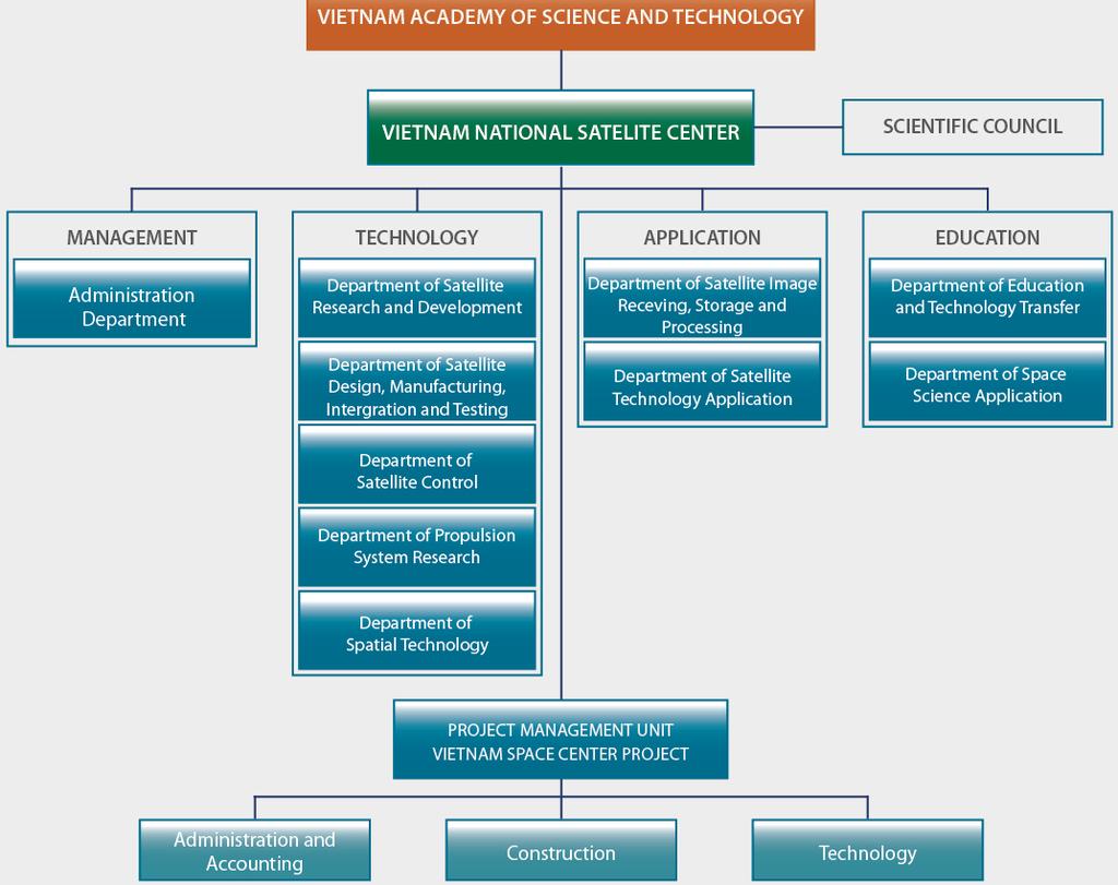
9 Project: Place: Area: 09 ha Duration: Capital: Owner: Executing Agency: Vietnam National Space Center Hoa Lac Hi-tech Park billion Yen Vietnam Academy of Science and Technology (VAST) Vietnam National Satellite Center (VNSC)
10 The Project consists of three main components: Satellite Technology 02 SAR Observation Satellite Facility Assembling, integration & test facility Data image receiving and processing facility Research and education facility Capacity Development Small satellite development Remote sensing technology

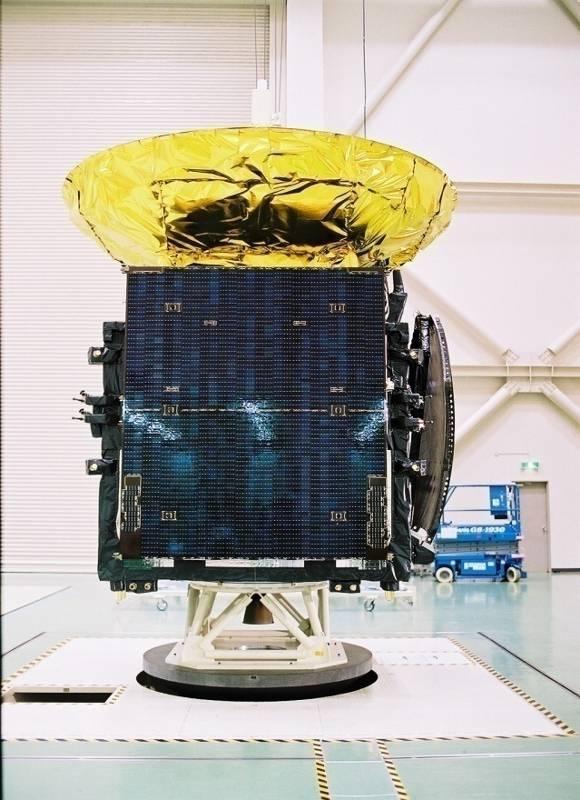
11 SAR Observation Satellite Mass: 500kg Life: 5 years Size: Approx. 2.6m x 3.5m x 3m <Mission> X-band SAR sensor Spatial resolution ~ 1.0m Source: JICA Survey Team
12 Source: JICA Survey Team

13


14 Data Receive & Archive Equipment Antenna 7m Satellite Operation Equipment Data Archive & processing center

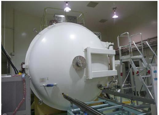
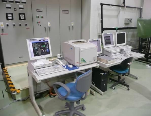
15 Thermal vacuum Test Facility Electromagnetic Test Facility Satellite Integration Facility Vibration Test Facility Satellite Operation Center
16 The objects of capacity development are staff working for VNSC who are in charge of: Overall management of VNSC: 18 staffs Satellite production and operation: 36 engineers Satellite data utilization: 30 engineers
17
18 VNREDSat-1 (Vietnam Natural Resources, Environment and Disaster monitoring satellite system) Project Owner: Vietnam Academy of Science and Technology Small Satellite Project Management Unit Implementation period: Finance source: Fund: Prime contractor: Main Items: French ODA 55,8 million Euro EADS Astrium 1.Design, manufacture and launch of VNREDSat-1 satellite 2.Establishment of a Satellite Ground Control Station 3.Upgrade of the Remote Sensing Receiving Station (Vietnam National Remote Sensing Center, MONRE) 4.Satellite image calibration site 5.Procurement of Launch and Insurance services for VNREDSat-1 satellite 6.Setting up a communication links between Ground stations 7.Training and Transfer of Small Satellite Technology

19 VNREDSat-1 (Vietnam Natural Resources, Environment and Disaster monitoring satellite system) The 1 st optical earth observation satellite in Vietnam Mission: Earth observation in PAN and 4 MS spectral bands Revisit time: 3 days Orbit characteristics: SSO, 680 km altitude Spatial resolution: 2.5m (PAN) và 10m (MS) Dimensions: 600 mm x 570 mm x 500 mm Total mass: ~130kg Life-time: 5 years Launch date: 2013


20 VNREDSat-1b (Vietnam Natural Resources, Environment and Disaster monitoring satellite system) Orbit characteristics: SSO, altitude ~600km Heritages: successful launchs of PROBA 1,2 PROBA V, PROBA 3 and PROBA Altius (~100kg, 80x60x60cm, piggyback launch) Revisit time: 3 days Ground station located in Hanoi with 3-4 satellite contacts/day Wide swath width: km Finance source: Belgium ODA Fund: 63 million Euro Launch date: 2017
21
22 Vietnam s telecommunications satellite (VINASAT) provide communication for fishermen at sea, deliver weather forecasts and ensure defense security. VINASAT-1 launched 2008, It cover Vietnam, Laos, Cambodia, Thailand and part of Myanmar. 7/2012: 90% of Vinasat-1 frequency band capacity is used. Main customers of Vinasat-1 : VTV, VTC, VOV, HTV, oil industry, telecommunication groups: Thaicom, Lao Telecom, WebsatMedia (Singapore).

23 Currently there are 150 TV standard HD, SD channels are provided on frequency band of Vinasat-1. Vinasat-1 helps Vietnam save 15 millions USD/year from renting foreign telecommunication satellite channels. VNPT expects payback period of billions VND for Vinasat-1 is 10 years and get return on investment in the next 5 years.
24 VINASAT-2 have: Provide to 13,000 channels of telephone/internet/data communications or 150 Television channels greater number of sensor responses higher frequency band capacity minimum lifetime is 15 years from transceivers

25 VINASAT-2 have: Total mass: 3,000 kg Launch date: May 16t h, 2012 Official exploitation date: 14/7/2012 Vinasat-2 main customers are on wider range of business such as: oil, bank, finance. It focus on customers who wish to communicate in remote, border and island areas, and foreign customers including Lao, Cambodia and Myanmar.
26 Projects for Satellite Data Utilization
27 The system of remote sensing technology to acquire the satellite image data key, image processing, establishment of information systems, upgrading systems for remote sensing application fields in Vietnam: Donor: Gov. of France Amount: 19 mil (ODA), 50 bill. VND (GOV funding) Duration: Project Owner: MONRE Satellite image receiving station (VNGS); Remote Sensing Center National Data (NDC); The Center for Applications (DUS) of the industry Receive data from SPOT-2, 4, 5 and ENVISAT ASAR/MERIS
28 Monitoring of marine resources and marine areas of Vietnam through satellite: Donor: Gov. of France Amount: 13.9M (ODA) Duration: Project Owner: MARD

29
The 1st AOSWA Workshop Chiang Mai, 22-24/2/2012
 The 1st AOSWA Workshop Chiang Mai, 22-24/2/2012 SPACE TECHNOLOGY DEVELOPMENT & APPLICATIONS FOR CLIMATE CHANGE MITIGATION IN VIETNAM Doan Minh Chung Space Technology Institute (STI) Vietnam Academy of
in Developing Countries in FY2008
 Study on Economic Partnership Projects in Developing Countries in FY2008 Study on Research and Development Center for Space Technology of Vietnam Academy of Science and Technology in Hoa Lac in Socialist
SPACE TECHNOLOGY INSTITUTE AND VNREDSat-1
 The First Steering Committee (FSC) of The Sentinel Asia Step 3 13-15 Oct 2015 SPACE TECHNOLOGY INSTITUTE AND VNREDSat-1 Ngo Duy Tan Deputy Director, Centre for Small Satellite Control and Exploitation,
Results of Implementation of National Strategy for Research and Application of Space Technology up to 2020 ( )
") Results of Implementation of National Strategy for Research and Application of Space Technology up to 2020 (2016-2017) Dao Ngoc Chien, Ph.D Deputy Director-General Department of High Technologies, Ministry
Results of Implementation of National Strategy for Research and Application of Space Technology up to 2020 (2016-2017) Dao Ngoc Chien, Ph.D Deputy Director-General Department of High Technologies, Ministry
Copernicus Introduction Lisbon, Portugal 13 th & 14 th February 2014
 Copernicus Introduction Lisbon, Portugal 13 th & 14 th February 2014 Contents Introduction GMES Copernicus Six thematic areas Infrastructure Space data An introduction to Remote Sensing In-situ data Applications
Ex-Ante Evaluation (for Japanese ODA Loan)
") Japanese ODA Loan Ex-Ante Evaluation (for Japanese ODA Loan) 1. Name of the project Country: The Socialist Republic of Viet Nam Project: Hoa Lac Science and Technology City Development Project (II) Loan
Japanese ODA Loan Ex-Ante Evaluation (for Japanese ODA Loan) 1. Name of the project Country: The Socialist Republic of Viet Nam Project: Hoa Lac Science and Technology City Development Project (II) Loan
Drafting Committee for the Asia Pacific Plan of Action for Space Applications for Sustainable Development ( ) Republic of Korea
 Republic of Korea") Drafting Committee for the Asia Pacific Plan of Action for Space Applications for Sustainable Development (2018 2030) Republic of Korea Bangkok, Thailand 31 May 1 June 2018 김 1 KARI Introduction Government
Drafting Committee for the Asia Pacific Plan of Action for Space Applications for Sustainable Development (2018 2030) Republic of Korea Bangkok, Thailand 31 May 1 June 2018 김 1 KARI Introduction Government
Dr. PHẠM ANH TUẤN The Director of Vietnam National Satellite Center
 Interview with CEO Dr. PHẠM ANH TUẤN The Director of Vietnam National Satellite Center Thank you for taking the time out of your busy schedule for this interview. We appreciate the contribution you have
INTEGRATED COASTAL MANAGEMENT IN VIETNAM: OPPORTUNITIES AND CHALLENGES. Pham Van Lam Agency of Islands and Seas Use Management 15/11/2015
 INTEGRATED COASTAL MANAGEMENT IN VIETNAM: OPPORTUNITIES AND CHALLENGES Pham Van Lam Agency of Islands and Seas Use Management 15/11/2015 Contents 1.Beginning of ICM in Viet Nam 2.Achievements 3.Difficulties
SMART GEOSPATIAL 2014
 SMART GEOSPATIAL 2014 Seoul, 25-28 Aug. 2014 DR. BUI VAN QUYEN GENERAL DIRECTOR MINISTER ASSISTANT, MINISTRY OF SCIENCE AND TECHNOLOGY, VIETNAM Vietnam area: 330,000 km2; Population: 90 million Vietnam
Vega Market Opportunities
 Vega Market Opportunities Workshop on VV02 Success ASI, Rome - Contents Space Applications Applications & Launcher Performance Vega Market Mostly Earth Observation Earth Observation Segment Launch Service
The Challenge. SPOT Vegetation. miniaturization. Proba Vegetation. Technology assessment:
 The Challenge Spot-5 lifetime expires in 2012. The next French satellite, Pleiades, is solely dedicated to HiRes. The Belgian Federal Science Policy Office (BELSPO) declared their interest to develop an
Introduction to Galileo PRS
 Introduction to Galileo PRS Fabio Covello 20/09/2017 ESA UNCLASSIFIED - For Official Use Galileo mission figures The Galileo Space Segment: 30 satellites (full constellation) Walker 24/3/1 constellation
WHAT IS NEXT IN EARTH OBSERVATION. SkyMed Mission
 WHAT IS NEXT IN EARTH OBSERVATION COSMO-SkyMed SkyMed Mission Paolo Ammendola Italian Space Agency Florence, Sept. 19, 2001 ammendola@asi asi.it THE NEEDS Market studies indicate that the value of the
Affordable space based radar for homeland security
 Changing the economics of space Affordable space based radar for homeland security Adam Baker Brent Abbott Phil Whittaker Rachel Bird Luis Gomes Summary Why Radar? However: Radar data is expensive Users
Launchers. News from. Europe s Spaceport. 70 esa bulletin november
 Launchers News from 70 esa bulletin 112 - november 2002 www.esa.int Fernando Doblas Head of the Kourou Office, ESA Directorate of Launchers, French Guiana Introduction Since 1975, the availability of an
The use of satellite images to forecast agricultural
 The use of satellite images to forecast agricultural Luxembourg, 12.03.2014 r. Tomasz Milewski NUTS for Poland: NUTS 1 macro-regions (grup of province, voivodships) (6), NUTS 2 - regions (province,
Update on Landsat Program and Landsat Data Continuity Mission
 Update on Landsat Program and Landsat Data Continuity Mission Dr. Jeffrey Masek LDCM Deputy Project Scientist NASA GSFC, Code 923 November 21, 2002 Draft LDCM Implementation Phase RFP Overview Page 1 Celebrate!
Data Sharing Issues in SE Asia
 Data Sharing Issues in SE Asia Kandasri Limpakom User Service and Business Development Office About GISTDA THEOS & Its Applications GISTDA s Data Sharing Geo-Informatics and Space Technology Development
Development of Microsatellite to Detect Illegal Fishing MS-SAT
 Development of Microsatellite to Detect Illegal Fishing MS-SAT Ernest S. C. P. Bintang A.S.W.A.M. Department of Aerospace Engineering Faculty of Mechanical and Aerospace Engineering Institut Teknologi
SOME ASPECT AND PERSPECTIVES OF IMPLEMENTATION OF THE NATIONAL POLICY IN THE FIELD OF EXPLORATION AND PEACEFUL USES OF OUTER SPACE
 SOME ASPECT AND PERSPECTIVES OF IMPLEMENTATION OF THE NATIONAL POLICY IN THE FIELD OF EXPLORATION AND PEACEFUL USES OF OUTER SPACE 1 Folie 1 NKS Raumfahrt, Dr. Adrian klein Background National Academy
RADARSAT-2 Program Update Daniel De Lisle Canadian Space Agency
 RADARSAT-2 Program Update Daniel De Lisle Canadian Space Agency Presentation outline RADARSAT-1 Update RADARSAT-2 Mission description Mission Objectives System Characteristics Data Commercialization/Allocation
EARTH OBSERVATION WITH SMALL SATELLITES
 EARTH OBSERVATION WITH SMALL SATELLITES AT THE FUCHS-GRUPPE B. Penné, C. Tobehn, M. Kassebom, H. Lübberstedt OHB-System GmbH, Universitätsallee 27-29, D-28359 Bremen, Germany www.fuchs-gruppe.com ABSTRACT
Coastal Surveillance. SCANTER Radar Solutions
 Coastal Surveillance SCANTER Radar Solutions Protecting Your Coastlines and Maritime Domain We provide radar coverage of the coastline to detect and track all types of surface vessels and air targets.
Geospatial Vision and Policies Korean Industry View 26 November, 2014 SI Imaging Services
 Geospatial Vision and Policies Korean Industry View 26 November, 2014 SI Imaging Services Distribution Limitation, SI Imaging Services Proprietary Data : The data contained in this document, without the
United nation, Vienna, 9-13 February 2015
 United nation, Vienna, 9-13 February 2015 RUSSIAN FEDERAL SPACE AGENCY In the Russian Federation, the federal agency in charge of space activities is the Russian Federal Space Agency (Roscosmos) Earth
IPSTAR Project. Shin Satellite Public Company Limited 19
 IPSTAR Project This is SATTEL s next satellite project to be launched in 2004 and will cover Asia and Australia. The region is known for its fast-growing telecommunications business. The Company is currently
Mission requirements and satellite overview
 Mission requirements and satellite overview E. BOUSSARIE 1 Dual concept Users need Defence needs Fulfil the Defence needs on confidentiality and security Civilian needs Fulfillment of the different needs
Study on. Present Status and Future Plan on Vietnam s Optical Earth Observation Satellite for Disaster and Climate Change Countermeasure.
 Study on Present Status and Future Plan on Vietnam s Optical Earth Observation Satellite for February 2018 METI Study Team PADECO Co., Ltd Remote Sensing Technology Center of Japan Japan Space Systems
ERS/ENVISAT ASAR Data Products and Services
 ERS/ENVISAT ASAR Data Products and Services Andrea Celentano Business Manager celentan@eurimage.com What is Eurimage? Founded in 1989 Current shareholders: Since 1989 Commercial Partner of the European
GMES DA COPERNICUS
 2014 Airbus Defence and Space All rights reserved. The reproduction, distribution and utilization of this document as well as the communication of its contents to others without express authorization is
BAFFLES DESIGN OF THE PROBA-V WIDE FOV TMA
 BAFFLES DESIGN OF THE PROBA-V WIDE FOV TMA A. Mazzoli 1, P. Holbrouck 2, Y. Houbrechts 1, L. Maresi 3, Y. Stockman 1, M.Taccola 3, J. Versluys 2. 1 Centre Spatial de Liège (CSL), University of Liège, Avenue
The studies began when the Tiros satellites (1960) provided man s first synoptic view of the Earth s weather systems.
 provided man s first synoptic view of the Earth s weather systems.") Remote sensing of the Earth from orbital altitudes was recognized in the mid-1960 s as a potential technique for obtaining information important for the effective use and conservation of natural resources.
Remote sensing of the Earth from orbital altitudes was recognized in the mid-1960 s as a potential technique for obtaining information important for the effective use and conservation of natural resources.
9/12/2011. Training Course Remote Sensing Basic Theory & Image Processing Methods September 2011
 Training Course Remote Sensing Basic Theory & Image Processing Methods 19 23 September 2011 Popular Remote Sensing Sensors & their Selection Michiel Damen (September 2011) damen@itc.nl 1 Overview Low resolution
Landslide Prediction Mission In Cooperation with Hillside Sensor Network Robots Futaiten Project
 Landslide Prediction Mission In Cooperation with Hillside Sensor Network Robots Futaiten Project MIC4 21 October 2016 Ryuichi Sekita Associate Professor Department of Smart System Fukuyama University Hiroshima,
ISIS TC Meeting. International Spaceborne Imaging Spectroscopy (ISIS) GRSS Technical Committee Meeting, 16/07/2014, IGARSS 2014
 GRSS Technical Committee Meeting, 16/07/2014, IGARSS 2014") ISIS TC Meeting International Spaceborne Imaging Spectroscopy (ISIS) GRSS Technical Committee Meeting, 16/07/2014, IGARSS 2014 Andreas Müller (DLR) Cindy Ong (CSIRO) Uta Heiden (DLR) Agenda Hyperspectral
ISIS TC Meeting International Spaceborne Imaging Spectroscopy (ISIS) GRSS Technical Committee Meeting, 16/07/2014, IGARSS 2014 Andreas Müller (DLR) Cindy Ong (CSIRO) Uta Heiden (DLR) Agenda Hyperspectral
SSC space expertise on the ground
 SSC space expertise on the ground FMV Sensor Symposium Stockholm, September 2016 Björn Ohlson and Petrus Hyvönen Satellite Services for Surveillance & Reconnaissance Navigation Communication and Space
AstroBus S, the high performance and competitive Small Satellites platform for Earth Observation
 AstroBus S, the high performance and competitive Small Satellites platform for Earth Observation Dr. Jean Cheganças 10th IAA Symposium on Small Satellites for Earth Observation April 20-24, 2015 Berlin,
From the JUSTSAP to the PISA
 From the JUSTSAP to the PISA Osamu Odawara, Tokyo Institute of Technology Japan-US Science, Technology, and Space Application Program Pacific International Space Alliance JUSTSAP ( established in 1990
GLOBAL SATELLITE SYSTEM FOR MONITORING
 MEETING BETWEEN YUZHNOYE SDO AND HONEYWELL, International Astronautical Congress IAC-2012 DECEMBER 8, 2009 GLOBAL SATELLITE SYSTEM FOR MONITORING YUZHNOYE SDO PROPOSALS FOR COOPERATION WITH HONEYWELL EARTH
COSMO-SkyMed Mission Status Presented by Giovanni VALENTINI (ASI)
") COSMO-SkyMed Mission Status Presented by Giovanni VALENTINI (ASI) FIRST SATELLITE FIRST SATELLITE OF THE CONSTELLATION SUCCESSFULLY LAUNCHED 08 June 2007 03:35 (GMT) Vandenberg U.S.A. Air Force Base SECOND
COSMO-SkyMed Mission Status Presented by Giovanni VALENTINI (ASI) FIRST SATELLITE FIRST SATELLITE OF THE CONSTELLATION SUCCESSFULLY LAUNCHED 08 June 2007 03:35 (GMT) Vandenberg U.S.A. Air Force Base SECOND
SPACE TECHNOLOGY IN MONGOLIA
 United Nations/United Arab Emirates High Level Forum Space as a driver for socio-economic sustainable development 20 24 November 2016 SPACE TECHNOLOGY IN MONGOLIA Ms.Oyuntsetseg.B Deputy Director of Space
SAR Interferometry Capabilities of Canada's planned SAR Satellite Constellation
 SAR Interferometry Capabilities of Canada's planned SAR Satellite Constellation Dirk Geudtner, Guy Séguin,, Ralph Girard Canadian Space Agency RADARSAT Follow-on Program CSA is in the middle of a Phase
Iridium NEXT SensorPODs: Global Access For Your Scientific Payloads
 Iridium NEXT SensorPODs: Global Access For Your Scientific Payloads 25 th Annual AIAA/USU Conference on Small Satellites August 9th 2011 Dr. Om P. Gupta Iridium Satellite LLC, McLean, VA, USA Iridium 1750
National SPace Organization
 National SPace Organization A center of innovation and excellence for space technology Bo Chen National Space Organization Presented at JPTM 2014, Sentinel Asia Yangon, Myanmar, 11/19-21 NARLabs-NSPO About
Orbicraft Pro Complete CubeSat kit based on Raspberry-Pi
 Orbicraft Pro Complete CubeSat kit based on Raspberry-Pi (source IAA-AAS-CU-17-10-05) Speaker: Roman Zharkikh Authors: Roman Zharkikh Zaynulla Zhumaev Alexander Purikov Veronica Shteyngardt Anton Sivkov
Indian Remote Sensing Satellites
 Resourcesat-1 Indian Remote Sensing Satellites -Current & Future Resourcesat Missions - Presented by: Timothy J. Puckorius Chairman & CEO EOTec 1 Presentation Topics India s Earth Observation Heritage
MASTER IN SPACE EARTH OBSERVATION, ASTROPHYSICS, SATELLITE TECHNOLOGIES
 UNIVERSITY OF SCIENCE AND TECHNOLOGY OF HANOI TRƯỜNG ĐẠI HỌC KHOA HỌC VÀ CÔNG NGHỆ HÀ NỘI MASTER IN SPACE EARTH OBSERVATION, ASTROPHYSICS, SATELLITE TECHNOLOGIES The only master degree in space sciences
NovaSAR-S - Bringing Radar Capability to the Disaster Monitoring Constellation
 Changing the economics of space NovaSAR-S - Bringing Radar Capability to the Disaster Monitoring Constellation SSTL: Philip Davies, Phil Whittaker, Rachel Bird, Luis Gomes, Ben Stern, Prof Sir Martin Sweeting
Leveraging Commercial Communication Satellites to support the Space Situational Awareness Mission Area. Timothy L. Deaver Americom Government Services
 Leveraging Commercial Communication Satellites to support the Space Situational Awareness Mission Area Timothy L. Deaver Americom Government Services ABSTRACT The majority of USSTRATCOM detect and track
Disruptive technologies and future trends of small satellites
 2016 SSTL Disruptive technologies and future trends of small satellites Luis Gomes Director of EO & science Surrey Satellite Technology Limited Radio Communication June 1978 2016 SSTL The DMC and RapidEye
Lecture 6: Multispectral Earth Resource Satellites. The University at Albany Fall 2018 Geography and Planning
 Lecture 6: Multispectral Earth Resource Satellites The University at Albany Fall 2018 Geography and Planning Outline SPOT program and other moderate resolution systems High resolution satellite systems
Country Experience On Satellite Service Regulatory Framework
 Country Experience On Satellite Service Regulatory Framework MD. GOLAM RAZZAQUE Project Director Bangabandhu Satellite Launching Project Bangladesh Telecommunication Regulatory Commission ITU Satellite
Satellite services for maritime security
 Satellite services for ITS-T Sophia Antipolis 6 June 2007 Jean-Pierre Cauzac, CLS - Collecte Localisation Satellites 35 Are the seas becoming more dangerous? IMB report 2006 shows improvement: 239 piracy
The world s most advanced constellation
 The DigitalGlobe Constellation The world s most advanced constellation of very high-resolution satellites The world s most advanced constellation The DigitalGlobe constellation of high-resolution satellites
Aral Sea profile Selection of area 24 February April May 1998
 250 km Aral Sea profile 1960 1960 1985 1986 1987 1988 1989 1990 1991 1992 1993 1994 1995 1996 1997 1998 2010? Selection of area Area of interest Kzyl-Orda Dried seabed 185 km Syrdarya river Aral Sea Salt
Cost Effective Control of your Coastal Waters
 Cost Effective Control of your Coastal Waters Olov Fäst SSC Airborne Systems 2013-07-03 SSC: A comprehensive space industry Founded in 1972 ~650 employees (2012) ~100 M turnover (2012) Since the start
XSAT Ground Segment at CRISP
 XSAT Ground Segment at CRISP LIEW Soo Chin Head of Research, CRISP http://www.crisp.nus.edu.sg 5 th JPTM for Sentinel Asia Step-2, 14-16 Nov 2012, Daejeon, Korea Centre for Remote Imaging, Sensing and
FORMOSAT-2, KOMPSAT-2, ASTROTERRA
 FORMOSAT-2, KOMPSAT-2, ASTROTERRA Igor Lampin, Didier Giacobbo - SPOT IMAGE S.A. GSCB Workshop, ESA/ESRIN Frascati FORMOSAT-2 Mission status F-2 is owned by Taiwan National Space Organisation (NSPO), designed
UNISCAN AND ALICE-SC GROUND STATIONS AND DEVELOPMENT OF THEIR NETWORKS
 UNISCAN AND ALICE-SC GROUND STATIONS AND DEVELOPMENT OF THEIR NETWORKS Gershenzon V.E., Gershenzon O.N. R&D Center ScanEx Commission WG IV/9 KEY WORDS: Uniscan, Alice-SC, Stations, Geo-Portals ABSTRACT:
ROLE OF SATELLITE DATA APPLICATION IN CADASTRAL MAP AND DIGITIZATION OF LAND RECORDS DR.T. RAVISANKAR GROUP HEAD (LRUMG) RSAA/NRSC/ISRO /DOS HYDERABAD
 RSAA/NRSC/ISRO /DOS HYDERABAD") ROLE OF SATELLITE DATA APPLICATION IN CADASTRAL MAP AND DIGITIZATION OF LAND RECORDS DR.T. RAVISANKAR GROUP HEAD (LRUMG) RSAA/NRSC/ISRO /DOS HYDERABAD WORKSHOP on Best Practices under National Land Records
ROLE OF SATELLITE DATA APPLICATION IN CADASTRAL MAP AND DIGITIZATION OF LAND RECORDS DR.T. RAVISANKAR GROUP HEAD (LRUMG) RSAA/NRSC/ISRO /DOS HYDERABAD WORKSHOP on Best Practices under National Land Records
Satellite Fleet for a Commercial Remote Sensing Company
 Satellite Fleet for a Commercial Remote Sensing Company Application Portfolio Danielle Wood December 5, 2007 Danielle Wood Page 1 of 16 December 5, 2007 Abstract This study considers the impacts of uncertainty
Outernet: Development of a 1U Platform to Enable Low Cost Global Data Provision
 Outernet: Development of a 1U Platform to Enable Low Cost Global Data Provision Introduction One of the UK s leading space companies, and the only wholly UK-owned Prime contractor. ISO 9001:2008 accredited
9/12/2011. Training Course Remote Sensing Basic Theory & Image Processing Methods September 2011
 Training Course Remote Sensing Basic Theory & Image Processing Methods 19 23 September 2011 Remote Sensing Platforms Michiel Damen (September 2011) damen@itc.nl 1 Overview Platforms & missions aerial surveys
Earth Observations from Space U.S. Geological Survey
 Earth Observations from Space U.S. Geological Survey Geography Land Remote Sensing Program Dr. Bryant Cramer April 1, 2009 U.S. Department of the Interior U.S. Geological Survey USGS Landsat Historical
SST radar in Cheia
 SST radar in Cheia 13.06.2018 Summary: About Space Alliance, Telespazio & RARTEL; Participation of RARTEL in ESA projects; Cheia antenna retrofit project 2 Telespazio in Romania: RARTEL SA RARTEL and the
OVERVIEW OF THE ALOS SATELLITE SYSTEM
 OVERVIEW OF THE ALOS SATELLITE SYSTEM Presented to The Symposium for ALOS Data Application Users @Kogakuin University, Tokyo, Japan Mar. 27, 2001 Takashi Hamazaki Senior Engineer ALOS Project National
COSMO-SkyMed Mission Status Presented by Fabrizio BATTAZZA (ASI)
") COSMO-SkyMed Mission Status Presented by Fabrizio BATTAZZA (ASI) COSMO-1 & COSMO-2 LAUNCHES FIRST SATELLITE OF THE CONSTELLATION SUCCESSFULLY LAUNCHED 08 June 2007 03:35 (GMT) Vandenberg U.S.A. Air Force
COSMO-SkyMed Mission Status Presented by Fabrizio BATTAZZA (ASI) COSMO-1 & COSMO-2 LAUNCHES FIRST SATELLITE OF THE CONSTELLATION SUCCESSFULLY LAUNCHED 08 June 2007 03:35 (GMT) Vandenberg U.S.A. Air Force
Satellite and GPS technology
 Satellite and GPS technology Maryna Strydom (GIS Tg SA) Tel: (011) 441 6163 mstrydom@srk.co.za Overview General How Earth Observation Satellites work Uses of different EOS outputs How GPS work Types of
NON-PHOTOGRAPHIC SYSTEMS: Multispectral Scanners Medium and coarse resolution sensor comparisons: Landsat, SPOT, AVHRR and MODIS
 NON-PHOTOGRAPHIC SYSTEMS: Multispectral Scanners Medium and coarse resolution sensor comparisons: Landsat, SPOT, AVHRR and MODIS CLASSIFICATION OF NONPHOTOGRAPHIC REMOTE SENSORS PASSIVE ACTIVE DIGITAL
PEGASUS : a future tool for providing near real-time high resolution data for disaster management. Lewyckyj Nicolas
 PEGASUS : a future tool for providing near real-time high resolution data for disaster management Lewyckyj Nicolas nicolas.lewyckyj@vito.be http://www.pegasus4europe.com Overview Vito in a nutshell GI
Spectrum licensing and spectrum auction in case study of Vietnam
 Spectrum licensing and spectrum auction in case study of Vietnam Mr. Nguyen Phi LONG Official of Frequency Assignment and Licensing Division ARFM - MIC Ha Noi, 11/2016 Outline 1. Introduction about Vietnam
Approach for Development and Commercialization of Micro and NanoTechnologies for Aerospace Applications Dr. OUDEA Coumar EADS-ST, and Member of Board
 Approach for Development and Commercialization of Micro and NanoTechnologies for Aerospace Applications Dr. OUDEA Coumar EADS-ST, and Member of Board of Directors CANEUS Organization CANEUS CANEUS began
Personnel: % Engineers & Management 31% Technicians 14% Administrative. Testing & PA 15% Staff 11% Engineering. Programmes 7% Production 36%
 CASA ESPACIO In 1966 the Space & Electronics Departments are created In 1984, both groups merge and the Space Division is created In 1999 CASA joins EADS CASA Espacio belongs to EADS Space Division with
Satellite Remote Sensing: Earth System Observations
 Satellite Remote Sensing: Earth System Observations Land surface Water Atmosphere Climate Ecosystems 1 EOS (Earth Observing System) Develop an understanding of the total Earth system, and the effects of
KONGSBERG SATELLITE SERVICES 2017 Line Steinbakk, Director Programs. Himmel og hav - Ålesund 3. Oktober 2017
 KONGSBERG SATELLITE SERVICES 2017 Line Steinbakk, Director Programs Himmel og hav - Ålesund 3. Oktober 2017 KSAT HQ IN TROMSØ 69N Established in 1967 Kongsberg Satellite Services since 2002 World leading
Benefits analysis. Benefit categorisation. Lesley Murphy QinetiQ. ESA Space Weather Programme study Final presentation, 6th-7th December 2001
 Benefits analysis Lesley Murphy QinetiQ ESA Space Weather Programme study Final presentation, 6th-7th December 2001 Benefit categorisation STRATEGIC - affecting Europe s industrial, military, technological
Clean Space. A new cross-cutting initiative of ESA. The Clean Space Team 15/04/2013. ESA UNCLASSIFIED For Official Use
 Clean Space A new cross-cutting initiative of ESA The Clean Space Team 15/04/2013 Index Introduction Clean Space Branch 3 Space debris mitigation Branch 4 Space debris remediation Implementation Conclusions
Trend of Small EO Satellites and Their Applications
 UN Symposium to Strengthen the Partnership with Industry Nurturing the Development of Space Technology Trend of Small EO Satellites and Their Applications For further information, Phone: +82 42 365 7506
Principles of Remote Sensing. Shuttle Radar Topography Mission S R T M. Michiel Damen. Dept. Earth Systems Analysis
 Principles of Remote Sensing Shuttle Radar Topography Mission S R T M Michiel Damen Dept. Earth Systems Analysis Contents Present problems with DEMs Advantage of SRTM Cell size Mission and system Radar
KOMPSAT Constellation. November 2012 Satrec Initiative
 KOMPSAT Constellation November 2012 Satrec Initiative KOMPSAT Constellation KOMPSAT National program Developed and operated by KARI (Korea Aerospace Research Institute) Dual use : Government & commercial
NEC s EO Sensors and Data Applications
 NEC s EO Sensors and Data Applications Second Singapore Space Symposium 30 September, 2015 Nanyang Technological University, Singapore Shimpei Kondo Space Technologies Department, Space System Division,
Futrajaya, Malaysia JULY 12, Jeong Heon SONG. Korea Aerospace Research Institution
 J P T M 2 0 1 1 Futrajaya, Malaysia JULY 12, 2011 Jeong Heon SONG Korea Aerospace Research Institution Outline Contribution of KARI Sentinel Asia / Data Provider Node International Charter KARI Space Activities
Coherent detection of weak Mode-S signals from Low Earth Orbit
 ADS-B over Satellite Coherent detection of weak Mode-S signals from Low Earth Orbit 4S Symposium, June 1 st 2016 in Valletta, Malta Toni Delovski, German Aerospace Center (DLR) Institute of Space Systems
Micro-STAR Potential Contribution to Human Safety and Security
 Micro-STAR Potential Contribution to Human Safety and Security Toto Marnanto Kadri Aeronautics Electronic Technology Center National Institute of Aeronautics and Space - LAPAN The 16 th Session of Asia
SPOT6. Impact of Spot 6 and 7 in the Constitution and Update of Spatial Data Infrastructures over Africa
 Astrium Services 2012 SPOT6 Impact of Spot 6 and 7 in the Constitution and Update of Spatial Data Infrastructures over Africa K. Guérin, M. Bernard, T. Rousselin, B. Navaro, J. Korona 26 th International
Monitoring Natural Disasters with Small Satellites Smart Satellite Based Geospatial System for Environmental Protection
 Monitoring Natural Disasters with Small Satellites Smart Satellite Based Geospatial System for Environmental Protection Krištof Oštir, Space-SI, Slovenia Contents Natural and technological disasters Current
Introduction to KOMPSAT
 Introduction to KOMPSAT September, 2016 1 CONTENTS 01 Introduction of SIIS 02 KOMPSAT Constellation 03 New : KOMPSAT-3 50 cm 04 New : KOMPSAT-3A 2 KOMPSAT Constellation KOMPSAT series National space program
AN EFFICIENT WARNING SYSTEM OF FLASH FLOOD FOR VIETNAM ABSTRACT
 AN EFFICIENT WARNING SYSTEM OF FLASH FLOOD FOR VIETNAM Sc. MA. Tran Anh TUAN 1, Prof. Dr. Phan ANH 2, Hoang Minh THONG 3 1, 2: Research Center for Electronics and Communication, Hanoi National University,
Final Examination Introduction to Remote Sensing. Time: 1.5 hrs Max. Marks: 50. Section-I (50 x 1 = 50 Marks)
") Final Examination Introduction to Remote Sensing Time: 1.5 hrs Max. Marks: 50 Note: Attempt all questions. Section-I (50 x 1 = 50 Marks) 1... is the technology of acquiring information about the Earth's
Final Examination Introduction to Remote Sensing Time: 1.5 hrs Max. Marks: 50 Note: Attempt all questions. Section-I (50 x 1 = 50 Marks) 1... is the technology of acquiring information about the Earth's
Volume 8, ISSN (Online), Published at:
, Published at:") DEVELOPMENT OF INFORMATION AND TELECOMMUNICATION AND SPACE TECHNOLOGIES USING NEW MECHANISMS OF TECHNOLOGICAL PLATFORMS Igor V. Kovalev, Yuri Y. Loginov, Pavel V. Zelenkov Siberian State Aerospace University
DEVELOPMENT OF INFORMATION AND TELECOMMUNICATION AND SPACE TECHNOLOGIES USING NEW MECHANISMS OF TECHNOLOGICAL PLATFORMS Igor V. Kovalev, Yuri Y. Loginov, Pavel V. Zelenkov Siberian State Aerospace University
KNACKSAT * : A Thai Educational Satellite
 KNACKSAT * : A Thai Educational Satellite Suwat Kuntanapreeda, Pongsatorn Saisutjarit, Suramate Chalermwisutkul King Mongkut s University of Technology North Bangkok (KMUTNB) Bangkok, Thailand *KNACKSAT:
detected by Himawari-8 then the location will be uplinked to approaching Cubesats as an urgent location for medium resolution imaging.
 Title: Cubesat constellation for monitoring and detection of bushfires in Australia Primary Point of Contact (POC) & email: siddharth.doshi2@gmail.com Co-authors: Siddharth Doshi, David Lam, Himmat Panag
Small satellites deployment mission from. "Kibo" Engineer, Hiroki AKAGI
 APRSAF-22, SEU-WG Small satellites deployment mission from "Kibo" Engineer, Hiroki AKAGI Japan Aerospace Exploration Agency Human Spaceflight Technology Directorate JEM Mission Operations and Integration
Istanbul Technical University Faculty of Aeronautics and Astronautics Space Systems Design and Test Laboratory
 Title: Space Advertiser (S-VERTISE) Primary POC: Aeronautics and Astronautics Engineer Hakan AYKENT Organization: Istanbul Technical University POC email: aykent@itu.edu.tr Need Worldwide companies need
EUROPEAN SPACE AGENCY INDUSTRIAL POLICY COMMITTEE
 Att. : Annexes Paris, 20 th March 2008 (English only) EUROPEAN SPACE AGENCY INDUSTRIAL POLICY COMMITTEE GENERAL SUPPORT TECHNOLOGY PROGRAMME UPDATE OF THE GSTP-4 SPECIFIC AREA WORK PLAN AND PROCUREMENT
Landsat and the Data Continuity Mission
 Carl E. Behrens Specialist in Energy Policy May 22, 2009 Congressional Research Service CRS Report for Congress Prepared for Members and Committees of Congress 7-5700 www.crs.gov R40594 Summary The U.S.
Satellite Technology for Future Applications
 Satellite Technology for Future Applications WSRF Panel n 4 Dubai, 3 March 2010 Guy Perez VP Telecom Satellites Programs 1 Commercial in confidence / All rights reserved, 2010, Thales Alenia Space Content
AMIPAS. Advanced Michelson Interferometer for Passive Atmosphere Sounding. Concepts and Technology for Future Atmospheric Chemistry Sensors
 Earth Observation, Navigation & Science Concepts and Technology for Future Atmospheric Chemistry Sensors AMIPAS Advanced Michelson Interferometer for Passive Atmosphere Sounding Markus Melf, Winfried Posselt,
The new German Space Strategy makes the space sector fit for the future Dr. Juergen Drescher DLR Washington Office
 The new German Space Strategy makes the space sector fit for the future Dr. Juergen Drescher DLR Washington Office 6th Eilene M. Galloway Symposium Washington D.C., December 1st, 2011 Space Policy of the