National SPace Organization
|
|
|
- Gwenda Collins
- 5 years ago
- Views:
Transcription


1 National SPace Organization A center of innovation and excellence for space technology Bo Chen National Space Organization Presented at JPTM 2014, Sentinel Asia Yangon, Myanmar, 11/19-21
2 NARLabs-NSPO About Us
 Governmental Agency Management & Funding National Applied Research Laboratories (NARL) Non-Profile Organization Management & Coordination National")
3 Organization Commitment.Passion.Innovation Ministry of Science and Technology (MOST) Governmental Agency Management & Funding National Applied Research Laboratories (NARL) Non-Profile Organization Management & Coordination National Nano Device Laboratories (NDL) National Laboratory Animal Center (NLAC) National Center for Research on Earthquake Engineering (NCREE) Instrument Technology Research Center (ITRC) National S&T Center for Disaster Reduction (NCDR) National Space Organization (NSPO) Earth sciences and environmental/ disaster mitigation technology National Chip Implementation Center (CIC) National Center for High-performance Computing (NCHC) Electronics, information, communications S&T Policy Research and Information Center (STPI) Taiwan Ocean Research Institute (TORI) Biomedical technology Taiwan Typhoon & Flood Research Institute (TTFRI) 3

 -3-4 -")
 -2 -7")
 -1")
4 FORMOSAT Programs FORMOSAT-5 (April yrs) FORMOSAT (May yrs) FORMOSAT-2 FORMOSAT-7 (Jan Jun 2004) FORMOSAT-1 4


")


5 NSPO Mid-term Plan Commitment.Passion.Innovation The 2 nd Phase Taiwan s Space Program Plan Mid-term Plan Self-reliant Spacecraft and Optic-Electric Remote Sensing Instrument Development Earth Observations FORMOSAT-2 Remote Sensing Satellite Program FORMOSAT-5 (Target Launch Date: 2015) FORMOSAT-5 Follow-on (FORMOSAT-8) EV Monitoring Disaster Support Data Applications GNSS RO Spacecraft and Constellation Operations Development Atmospheric Soundings FORMOSAT st Set Launch FORMOSAT nd Set Launch Weather Predication Climate Research Space Weather 5
 / MS (4m) Swath 24 km Spectral Bands PAN + 4MS RSI Image Sensor CMOS Image Sensor RSI")
6 The Key System Specification Commitment.Passion.Innovation Key Parameter Specification Orbit 720km/98.28 Revisit Period 2 days Mission Life 5 years GSD PAN (2m) / MS (4m) Swath 24 km Spectral Bands PAN + 4MS RSI Image Sensor CMOS Image Sensor RSI duty Cycle 8% Satellite Weight 525 kg 6


7 Formosat-5 & 8 Constellation GLOBAL Coverage + DAILY Revisit Commitment.Passion.Innovation Two-day Revisit Day 2, 4, Day 1, 3, FORMOSAT-8 FORMOSAT-5 Swath=24km Global Coverage FORMOSAT-8 operates in the adjacent ground track of FORMOSAT-5 to constitute the daily revisit and global coverage. 7 7


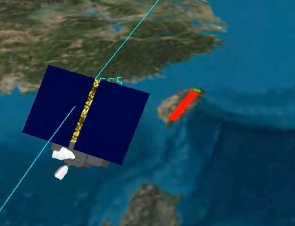
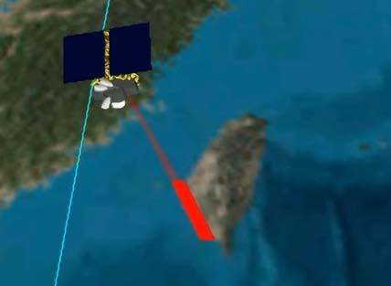
8 Smart Agility Capability Commitment.Passion.Innovation Multi-Tasking Stereo Imaging Along Coast Along Longitude Nominal Enhanced 8


; 6,000 20μm pixels (MS) FORMOSAT-5 will")
9 First HR EO Satellite Utilizing CIS Commitment.Passion.Innovation Largest CMOS Single Chip in the World 12 cm x 2.4 cm chip PAN+4 MS bands 12,000 10μm pixels (PAN); 6,000 20μm pixels (MS) FORMOSAT-5 will become the first high-resolution EO satellite utilizing CMOS-type image sensor. 9
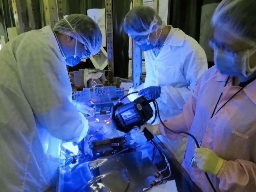
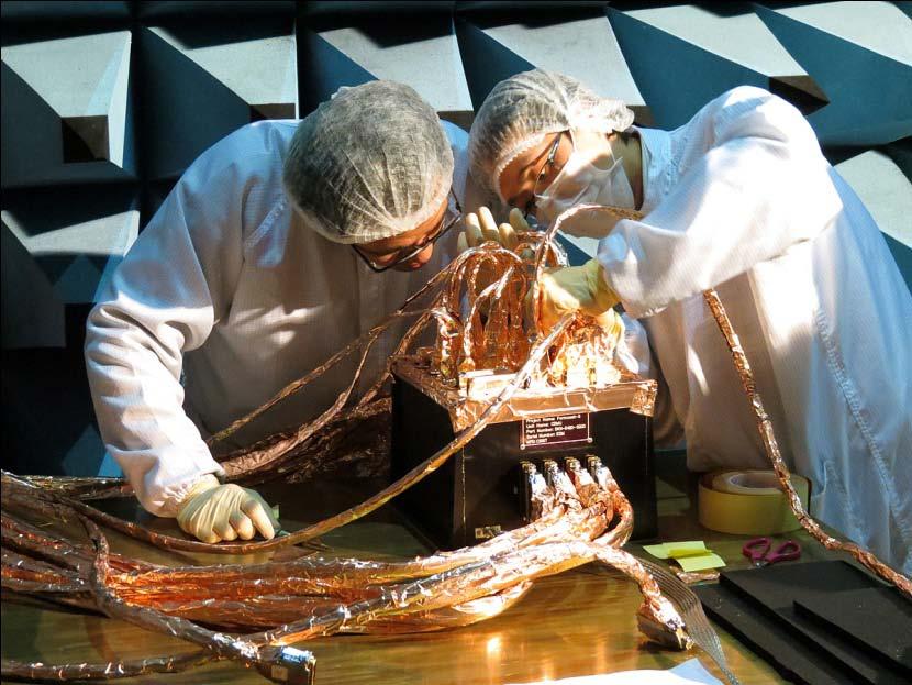
10 Highlights on FORMOSAT-5 Commitment.Passion.Innovation 10
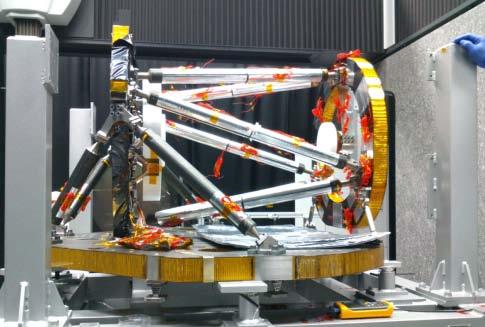
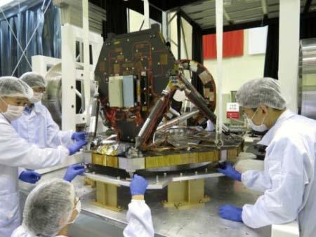
11 Highlights on FORMOSAT-5 Commitment.Passion.Innovation 11
12 NARLabs-NSPO supports to Sentinel Asia


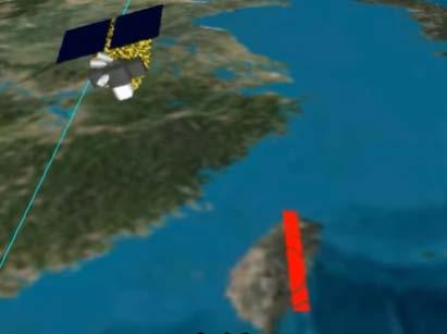
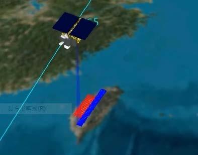
13 NARLabs-NSPO Supports to SA Commitment.Passion.Innovation Disaster Type Earthquake Landslide Tsunami Volcano eruption Flood Flash flood Others Total Environmental Monitoring for Asia Is being proposed to contribute to Platform for Image and Applications Services under SA umbrella 3D VR Application Courtesy: NCKU DPRC FS-2 Images on 11/13, 17, 18 after Haiyan Hit the Philippines 3D VR Application Post Disaster Image by FS-2 13
14 2014 Sentinel Asia EO Responses Place Name Of EO Period Mount Sinabung, Indonesia 2014/2/7~2014/2/13 Brunei 2014/1/18~2014/1/24 Tonga 2014/1/19~/2014/1/25 Jakarta, Indonesia 2014/1/22~2011/1/28 Inawashiro 2014/2/17~201/2/27 mount kelud, indonesia 2014/2/16~2014/2/23 Honiara, Solomon 2014/4/9~2014/4/16 Landslide, Tajikistan 2014/4/21~2014/4/27 Nagano prefecture, Japan 2014/7/12~2014/7/17 Kochi prefecture,japan 2014/8/5~2014/8/12 Takayama city, Japan 2014/8/19~2014/8/21 Hiroshima City, Japan 2014/8/21~2014/10/10 Flood, Vietnam 2014/8/22~2014/8/24 Flood_Dhemaji, Assam, India 2014/8/29~2014/9/4 Flood_Lakhimpur, Assam, India 2014/8/29~2014/9/4 Mt. Ontake, Japan 2014/10/1~2014/10/19 Sri Lanka 2014/11/1~2014/11/7 Total 17 Responses 14
15 Step-3 Activities Pre-disaster monitoring Heavy rainfall in Kochi prefecture,japan (08/03/2014) Heavy rainfall in Gifu prefecture,japan (08/18/2014) Extended EO Land-slide in Hiroshima City, Hiroshima prefecture,japan (08/20/2014) Volcano Eruption at Mt.Ontake in Nagano Prefecture, Japan (09/30/2014) 15


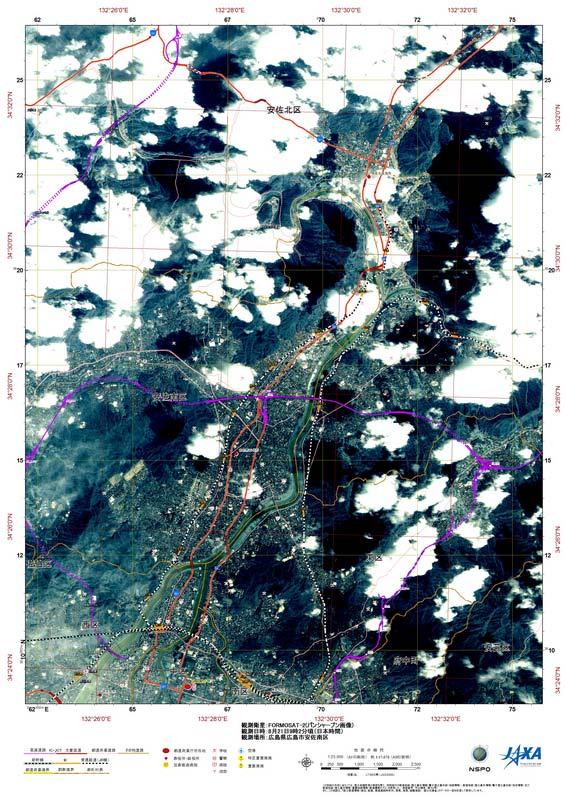

16 Hiroshima City, Japan (Period 2014/08/21~2014/10/10) 2014/09/ /09/ /09/ /09/ /09/ /09/16 16


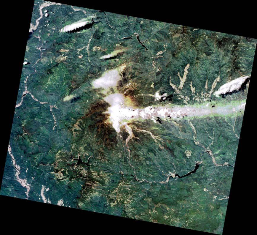
17 Mt. Ontake, Japan (Period 2014/10/3~2014/10/19) 2014/10/ /10/ /10/ /10/ /10/ /10/17 17
18 Good reasons to support step-3 Sentinel Asia Success story with JAXA and NARLabs/NCU Collaboration Kick-off meeting in JAXA (07/11/2014). Complementary utilization of SAR (ALOS-2) and Optical (FORMOSAT-2) data. Rapid response ALOS-2: accept EO request until one hour before observation, and provide data one hour after observation. FORMOSAT-2: accept EO request until 13:00 (JST), 16:00 if use dedicated scheduling tool via internet, on the previous day of observation, and provide data on that evening. FORMOSAT-2 rapid processing streaming We can now match the performance of ALOS-2 by providing data one hour after downlink. Embedded in a commercial activity NARLabs and RESTEC entered into a commercial agreement to sell FORMOSAT-2 Japan data, all data taken to support step-3 can also become products on the shelf. 18
19 Conclusion Remarks Commitment.Passion.Innovation NARLabs / NSPO is committed to continuously support of disaster reduction efforts and environmental observation for better living. Before high-levels endorse the free data policy, the Taiwan Japan experience could be a good approach for Sentinel Asia Step-3 to move forward. 19
20 20
FORMOSAT-2 Satellite and its Contributions to Disaster Reduction
 Session 1: Big datasets for disaster risk reduction APEC Workshop on Application of Big Data and Open Data 29-30 October 2015, Taipei FORMOSAT-2 Satellite and its Contributions to Disaster Reduction Ming-Chih
FORMOSAT-2 FOR INTERNATIONAL SOCIETAL BENEFITS
 FORMOSAT-2 FOR INTERNATIONAL SOCIETAL BENEFITS Ming-Chih Cheng 1, Celine Zhang 2 1 Researcher, 2 Research Assistant National Space Organization ABSTRACT The Group on Earth Observations (GEO), established
FORMOSAT-5. - Launch Campaign-
 1 FORMOSAT-5 - Launch Campaign- FORMOSAT-5 Launch Campaign 2 FORMOSAT-5 Launch Campaign Launch Date: 2017.08.24 U.S. Pacific Time Activities 11:50-12:23 Launch Window 13:30-16:00 Reception 3 FORMOSAT-5
WG5: AGRICULTURE & FOOD SECURITY FORMOSAT SATELLITES IN AGRICULTURAL MONITORING
 WG5: AGRICULTURE & FOOD SECURITY FORMOSAT SATELLITES IN AGRICULTURAL MONITORING Franz M.C. Cheng & Satellite Image Division National Space Organization, NARLabs www.nspo.org.tw franz.cheng@nspo.narl.org.tw
TAIWAN S SPACE PROGRAM DEVELOPMENT
 TAIWAN S SPACE PROGRAM DEVELOPMENT Shiann-Jeng Yu, Ming-Chih Cheng, Guey-Shin Chang. National Space Organization, 8F, 9 Prosperity 1st Road, Hsin-Chu Science Park, Hsin-Chu City, Taiwan Corresponding author:
Monitoring Natural Disasters with Small Satellites Smart Satellite Based Geospatial System for Environmental Protection
 Monitoring Natural Disasters with Small Satellites Smart Satellite Based Geospatial System for Environmental Protection Krištof Oštir, Space-SI, Slovenia Contents Natural and technological disasters Current
Futrajaya, Malaysia JULY 12, Jeong Heon SONG. Korea Aerospace Research Institution
 J P T M 2 0 1 1 Futrajaya, Malaysia JULY 12, 2011 Jeong Heon SONG Korea Aerospace Research Institution Outline Contribution of KARI Sentinel Asia / Data Provider Node International Charter KARI Space Activities
International Charter Space and Major Disasters
 International Charter Space and Major Disasters Sentinel Asia Joint Project Team Meeting July 7, 2010 Brenda Jones U.S. Geological Survey Charter Executive Secretariat Purpose An International agreement
XSAT Ground Segment at CRISP
 XSAT Ground Segment at CRISP LIEW Soo Chin Head of Research, CRISP http://www.crisp.nus.edu.sg 5 th JPTM for Sentinel Asia Step-2, 14-16 Nov 2012, Daejeon, Korea Centre for Remote Imaging, Sensing and
Advanced Optical Satellite (ALOS-3) Overviews
 Overviews") K&C Science Team meeting #24 Tokyo, Japan, January 29-31, 2018 Advanced Optical Satellite (ALOS-3) Overviews January 30, 2018 Takeo Tadono 1, Hidenori Watarai 1, Ayano Oka 1, Yousei Mizukami 1, Junichi
K&C Science Team meeting #24 Tokyo, Japan, January 29-31, 2018 Advanced Optical Satellite (ALOS-3) Overviews January 30, 2018 Takeo Tadono 1, Hidenori Watarai 1, Ayano Oka 1, Yousei Mizukami 1, Junichi
SPACE TECHNOLOGY INSTITUTE AND VNREDSat-1
 The First Steering Committee (FSC) of The Sentinel Asia Step 3 13-15 Oct 2015 SPACE TECHNOLOGY INSTITUTE AND VNREDSat-1 Ngo Duy Tan Deputy Director, Centre for Small Satellite Control and Exploitation,
Overview of Utilization of WINDS
 Overview of Utilization of WINDS 2nd Joint Project Team Meeting for Sentinel Asia STEP3 Yangon, Myanmar Sachiko Hozawa Space Application and Promotion Center (SAPC) Japan Aerospace Exploration Agency (JAXA)
Geospatial Vision and Policies Korean Industry View 26 November, 2014 SI Imaging Services
 Geospatial Vision and Policies Korean Industry View 26 November, 2014 SI Imaging Services Distribution Limitation, SI Imaging Services Proprietary Data : The data contained in this document, without the
Introduction of CSRSR Image product processing systems in CSRSR Disaster monitoring and data processing
 3 rd Joint Project Team Meeting for Sentinel Asia STEP3 Data Analysis Node Report Li-Yu Chang Associate Research Engineer Center for Space and Remote Sensing Research National Central University, Taiwan
Table Satellites used for observations by members of the Disaster Charter and others (except Daichi)
") 2.1.4 Cooperation with from overseas institutions JAXA asked Sentinel Asia and, on behalf of the Cabinet Office, the Disaster Charter to carry out emergency observations immediately after the earthquake
2.1.4 Cooperation with from overseas institutions JAXA asked Sentinel Asia and, on behalf of the Cabinet Office, the Disaster Charter to carry out emergency observations immediately after the earthquake
Introduction to KOMPSAT
 Introduction to KOMPSAT September, 2016 1 CONTENTS 01 Introduction of SIIS 02 KOMPSAT Constellation 03 New : KOMPSAT-3 50 cm 04 New : KOMPSAT-3A 2 KOMPSAT Constellation KOMPSAT series National space program
KOMPSAT Constellation. November 2012 Satrec Initiative
 KOMPSAT Constellation November 2012 Satrec Initiative KOMPSAT Constellation KOMPSAT National program Developed and operated by KARI (Korea Aerospace Research Institute) Dual use : Government & commercial
Big picture with KOMPSAT KOMPSAT-3A / KOMPSAT-3 / KOMPSAT-5 / KOMPSAT-2
 Big picture with KOMPSAT KOMPSAT-3A / KOMPSAT-3 / KOMPSAT-5 / KOMPSAT-2 Big picture with KOMPSAT Introduction SI Imaging Services (SIIS) is the exclusive worldwide marketing and sales representative of
Sensor resolutions from space: the tension between temporal, spectral, spatial and swath. David Bruce UniSA and ISU
 Sensor resolutions from space: the tension between temporal, spectral, spatial and swath David Bruce UniSA and ISU 1 Presentation aims 1. Briefly summarize the different types of satellite image resolutions
Sensor Technologies and Sensor Materials for Small Satellite Missions related to Disaster Management CANEUS Indo-US Cooperation
 Sensor Technologies and Sensor Materials for Small Satellite Missions related to Disaster Management CANEUS Indo-US Cooperation Suraj Rawal, Lockheed Martin Space Systems Co., USA G. Mohan Rao, Indian
Affordable space based radar for homeland security
 Changing the economics of space Affordable space based radar for homeland security Adam Baker Brent Abbott Phil Whittaker Rachel Bird Luis Gomes Summary Why Radar? However: Radar data is expensive Users
The 1st AOSWA Workshop Chiang Mai, 22-24/2/2012
 The 1st AOSWA Workshop Chiang Mai, 22-24/2/2012 SPACE TECHNOLOGY DEVELOPMENT & APPLICATIONS FOR CLIMATE CHANGE MITIGATION IN VIETNAM Doan Minh Chung Space Technology Institute (STI) Vietnam Academy of
Micro-STAR Potential Contribution to Human Safety and Security
 Micro-STAR Potential Contribution to Human Safety and Security Toto Marnanto Kadri Aeronautics Electronic Technology Center National Institute of Aeronautics and Space - LAPAN The 16 th Session of Asia
RADARSAT-2 Program Update Daniel De Lisle Canadian Space Agency
 RADARSAT-2 Program Update Daniel De Lisle Canadian Space Agency Presentation outline RADARSAT-1 Update RADARSAT-2 Mission description Mission Objectives System Characteristics Data Commercialization/Allocation
Outline. GPS RO Overview. COSMIC Overview. COSMIC-2 Overview. Summary 9/29/16
 Bill Schreiner and UCAR/COSMIC Team UCAR COSMIC Program Observation and Analysis Opportunities Collaborating with the ICON and GOLD Missions Sept 27, 216 GPS RO Overview Outline COSMIC Overview COSMIC-2
9/12/2011. Training Course Remote Sensing Basic Theory & Image Processing Methods September 2011
 Training Course Remote Sensing Basic Theory & Image Processing Methods 19 23 September 2011 Popular Remote Sensing Sensors & their Selection Michiel Damen (September 2011) damen@itc.nl 1 Overview Low resolution
GNSS (GPS) buoy array in the Pacific for natural disaster mitigation. Teruyuki KATO Earthquake Research Institute the University of Tokyo, Japan
 buoy array in the Pacific for natural disaster mitigation. Teruyuki KATO Earthquake Research Institute the University of Tokyo, Japan") GNSS (GPS) buoy array in the Pacific for natural disaster mitigation Teruyuki KATO Earthquake Research Institute the University of Tokyo, Japan 1 (Modified from Oki & Koketsu, 2011) Historical megaquakes
GNSS (GPS) buoy array in the Pacific for natural disaster mitigation Teruyuki KATO Earthquake Research Institute the University of Tokyo, Japan 1 (Modified from Oki & Koketsu, 2011) Historical megaquakes
EARTH OBSERVATION WITH SMALL SATELLITES
 EARTH OBSERVATION WITH SMALL SATELLITES AT THE FUCHS-GRUPPE B. Penné, C. Tobehn, M. Kassebom, H. Lübberstedt OHB-System GmbH, Universitätsallee 27-29, D-28359 Bremen, Germany www.fuchs-gruppe.com ABSTRACT
PEGASUS : a future tool for providing near real-time high resolution data for disaster management. Lewyckyj Nicolas
 PEGASUS : a future tool for providing near real-time high resolution data for disaster management Lewyckyj Nicolas nicolas.lewyckyj@vito.be http://www.pegasus4europe.com Overview Vito in a nutshell GI
Lecture 6: Multispectral Earth Resource Satellites. The University at Albany Fall 2018 Geography and Planning
 Lecture 6: Multispectral Earth Resource Satellites The University at Albany Fall 2018 Geography and Planning Outline SPOT program and other moderate resolution systems High resolution satellite systems
The 21st Session of the Asia-Pacific Regional Space Agency Forum (APRSAF): Dawn of a New Decade
: Dawn of a New Decade") The 21st Session of the Asia-Pacific Regional Space Agency Forum (APRSAF): Dawn of a New Decade 52 nd Session of Scientific and Technical Subcommittee Kazuhiro MIYAZAKI Office for Space Utilization Promotion,
The 21st Session of the Asia-Pacific Regional Space Agency Forum (APRSAF): Dawn of a New Decade 52 nd Session of Scientific and Technical Subcommittee Kazuhiro MIYAZAKI Office for Space Utilization Promotion,
Drafting Committee for the Asia Pacific Plan of Action for Space Applications for Sustainable Development ( ) Republic of Korea
 Republic of Korea") Drafting Committee for the Asia Pacific Plan of Action for Space Applications for Sustainable Development (2018 2030) Republic of Korea Bangkok, Thailand 31 May 1 June 2018 김 1 KARI Introduction Government
Drafting Committee for the Asia Pacific Plan of Action for Space Applications for Sustainable Development (2018 2030) Republic of Korea Bangkok, Thailand 31 May 1 June 2018 김 1 KARI Introduction Government
Synthetic Aperture Radar for Rapid Flood Extent Mapping
 National Aeronautics and Space Administration ARSET Applied Remote Sensing Training http://arset.gsfc.nasa.gov @NASAARSET Synthetic Aperture Radar for Rapid Flood Extent Mapping Sang-Ho Yun ARIA Team Jet
The world s most advanced constellation
 The DigitalGlobe Constellation The world s most advanced constellation of very high-resolution satellites The world s most advanced constellation The DigitalGlobe constellation of high-resolution satellites
Japan s View on Opportunities and New Approaches for Enhanced Multinational S&T Co-operation
 Japan s View on Opportunities and New Approaches for Enhanced Multinational S&T Co-operation March 25, 2009 Kimikazu IWASE Deputy Director General, Science and Technology Policy Bureau Ministry of Education,
The technical contribution of QZSS and GNSS to Tsunami early warning system
 0/17 Tsunami Workshop by Sentinel Asia @Sendai International Center Meeting Room 5 The technical contribution of QZSS and GNSS to Tsunami early warning system July 3, 2012 K. Mutoh, J. Yamashita, and S.
FORMOSAT-2, KOMPSAT-2, ASTROTERRA
 FORMOSAT-2, KOMPSAT-2, ASTROTERRA Igor Lampin, Didier Giacobbo - SPOT IMAGE S.A. GSCB Workshop, ESA/ESRIN Frascati FORMOSAT-2 Mission status F-2 is owned by Taiwan National Space Organisation (NSPO), designed
Remote Sensing Platforms
 Remote Sensing Platforms Remote Sensing Platforms - Introduction Allow observer and/or sensor to be above the target/phenomena of interest Two primary categories Aircraft Spacecraft Each type offers different
Microsatellite Ionospheric Network in Orbit
 Changing the economics of space Microsatellite Ionospheric Network in Orbit Dr Stuart Eves Lead Mission Concepts Engineer SSTL s.eves@sstl.co.uk In tribute to Mino Freund 1962-2012 Introduction Objective
SAR Interferometry Capabilities of Canada's planned SAR Satellite Constellation
 SAR Interferometry Capabilities of Canada's planned SAR Satellite Constellation Dirk Geudtner, Guy Séguin,, Ralph Girard Canadian Space Agency RADARSAT Follow-on Program CSA is in the middle of a Phase
CALL359 JAPAN S EARTHQUAKE 2011, MARCH, 11
 CALL359 JAPAN S EARTHQUAKE 2011, MARCH, 11 PM for International Charter Dr. Masahiko Nagai JAXA - AIT 25th Meeting of the International Charter May 12 th 2011 on 2011, March, 11 at 14:46 (JST) Iwate Pref.
Ubiquitous Sensing Network Research in NICT and Approach to Environment Measurements
 Ubiquitous Sensing Network Research in NICT and Approach to Environment Measurements Hiroshi Kumagai NICT: National Institute of Information and Communications Technology Japan 2005 Int l l Ubiquitous
From the JUSTSAP to the PISA
 From the JUSTSAP to the PISA Osamu Odawara, Tokyo Institute of Technology Japan-US Science, Technology, and Space Application Program Pacific International Space Alliance JUSTSAP ( established in 1990
The DigitalGlobe Constellation. World s Largest Sub-Meter High Resolution Satellite Constellation
 The DigitalGlobe Constellation World s Largest Sub-Meter High Resolution Satellite Constellation The DigitalGlobe Constellation The DigitalGlobe constellation of high resolution satellites offers incredible
GMES DA COPERNICUS
 2014 Airbus Defence and Space All rights reserved. The reproduction, distribution and utilization of this document as well as the communication of its contents to others without express authorization is
Time Trend Evaluations of Absolute Accuracies for PRISM and AVNIR-2
 The 3 rd ALOS Joint PI Symposium, Kona, Hawaii, US Nov. 9-13, 2009 Time Trend Evaluations of Absolute Accuracies for PRISM and AVNIR-2 Takeo Tadono*, Masanobu Shimada*, Hiroshi Murakami*, Junichi Takaku**,
Satellite Contributions to Disaster Monitoring - Japanese Earthquake and Tsunami Case in
 1 Satellite Contributions to Disaster Monitoring - Japanese Earthquake and Tsunami Case in 2011 - Akira Iwasaki, Satoshi Miyatani and Shinichi Nakasuka The University of Tokyo ASTER METI/NASA 2 We express
ROLE OF SATELLITE DATA APPLICATION IN CADASTRAL MAP AND DIGITIZATION OF LAND RECORDS DR.T. RAVISANKAR GROUP HEAD (LRUMG) RSAA/NRSC/ISRO /DOS HYDERABAD
 RSAA/NRSC/ISRO /DOS HYDERABAD") ROLE OF SATELLITE DATA APPLICATION IN CADASTRAL MAP AND DIGITIZATION OF LAND RECORDS DR.T. RAVISANKAR GROUP HEAD (LRUMG) RSAA/NRSC/ISRO /DOS HYDERABAD WORKSHOP on Best Practices under National Land Records
ROLE OF SATELLITE DATA APPLICATION IN CADASTRAL MAP AND DIGITIZATION OF LAND RECORDS DR.T. RAVISANKAR GROUP HEAD (LRUMG) RSAA/NRSC/ISRO /DOS HYDERABAD WORKSHOP on Best Practices under National Land Records
The studies began when the Tiros satellites (1960) provided man s first synoptic view of the Earth s weather systems.
 provided man s first synoptic view of the Earth s weather systems.") Remote sensing of the Earth from orbital altitudes was recognized in the mid-1960 s as a potential technique for obtaining information important for the effective use and conservation of natural resources.
Remote sensing of the Earth from orbital altitudes was recognized in the mid-1960 s as a potential technique for obtaining information important for the effective use and conservation of natural resources.
Sub-Mesoscale Imaging of the Ionosphere with SMAP
 Sub-Mesoscale Imaging of the Ionosphere with SMAP Tony Freeman Xiaoqing Pi Xiaoyan Zhou CEOS Workshop, ASF, Fairbanks, Alaska, December 2009 1 Soil Moisture Active-Passive (SMAP) Overview Baseline Mission
Improvement of emergency response with technology-based solutions
 National Science & Technology Center for Disaster Reduction Improvement of emergency response with technology-based solutions - Pre-disaster relief for reducing impacts by typhoon Liang-Chun Chen Chinese
GNSS buoy array in the ocean for natural hazard mitigation. Teruyuki KATO Earthquake Research Institute the University of Tokyo, Japan
 GNSS buoy array in the ocean for natural hazard mitigation Teruyuki KATO Earthquake Research Institute the University of Tokyo, Japan 1 GNSS applications in Earth science From static to high-rate observations
SAR missions for oceanography at the European Space Agency
 SAR missions for oceanography at the European Space Agency ERS-1, ERS-2, Envisat, Sentinel-1A, Sentinel-1B, ESA 3 rd Party Missions (ALOS) Prepared by ESA teams and ESA supporting companies ESA and SAR
Maximize Utilization of the performance of EOSs and strengthen. The First Steering Committee Secretariat JAXA
 Maximize Utilization of the performance of EOSs and strengthen cooperation among DPN/DAN The First Steering Committee Secretariat JAXA ALOS 2 observation is strong tool for disaster monitoring Wide area/range
COSMO-SkyMed Mission Status Presented by Giovanni VALENTINI (ASI)
") COSMO-SkyMed Mission Status Presented by Giovanni VALENTINI (ASI) FIRST SATELLITE FIRST SATELLITE OF THE CONSTELLATION SUCCESSFULLY LAUNCHED 08 June 2007 03:35 (GMT) Vandenberg U.S.A. Air Force Base SECOND
COSMO-SkyMed Mission Status Presented by Giovanni VALENTINI (ASI) FIRST SATELLITE FIRST SATELLITE OF THE CONSTELLATION SUCCESSFULLY LAUNCHED 08 June 2007 03:35 (GMT) Vandenberg U.S.A. Air Force Base SECOND
THE CURRENT STATUS OF ASIA OCEANIA MULTI-GNSS DEMONSTRATION CAMPAIGN. Multi-GNSS Asia Secretariat June 4 th, th ICG Providers Forum
 THE CURRENT STATUS OF ASIA OCEANIA MULTI-GNSS DEMONSTRATION CAMPAIGN 1 Multi-GNSS Asia Secretariat June 4 th, 2012 8 th ICG Providers Forum ASIA OCEANIA MULTI-GNSS DEMONSTRATION CAMPAIGN Multi-GNSS Monitoring
United nation, Vienna, 9-13 February 2015
 United nation, Vienna, 9-13 February 2015 RUSSIAN FEDERAL SPACE AGENCY In the Russian Federation, the federal agency in charge of space activities is the Russian Federal Space Agency (Roscosmos) Earth
Prospect for Global Positioning Augmentation Service by QZSS
 Prospect for Global Positioning Augmentation Service by QZSS Global Positioning Augmentation Service Corporation Director, Yoshikatsu Iotake Feb. 6, 2018 Copyright 2018 Global Positioning Augmentation
The Future of GNSS-RO for Global Weather Monitoring and Prediction A COSMIC-2 / FORMOSAT-7 Program Status Update
 The Future of GNSS-RO for Global Weather Monitoring and Prediction A COSMIC-2 / FORMOSAT-7 Program Status Update Kendra Cook Lead NOAA Systems Engineer C 2 International, LLC 2 October 2014 Co-Authors:
Disruptive technologies and future trends of small satellites
 2016 SSTL Disruptive technologies and future trends of small satellites Luis Gomes Director of EO & science Surrey Satellite Technology Limited Radio Communication June 1978 2016 SSTL The DMC and RapidEye
HyperSTREEGO A Reactive Multispectral Optical Payload for Small Satellites
 Driving Innovation in Space Optics and Optical Systems HyperSTREEGO A Reactive Multispectral Optical Payload for Small Satellites Giovanni Bianucci 1 Introduction Demand for remote sensing data is increasing
1. INTRODUCTION. GOCI : Geostationary Ocean Color Imager
 1. INTRODUCTION The Korea Ocean Research and Development Institute (KORDI) releases an announcement of opportunity (AO) to carry out scientific research for the utilization of GOCI data. GOCI is the world
(updates from last Plenary) AS Kiran Kumar ISRO, INDIA
 AS Kiran Kumar ISRO, INDIA") ISRO s EARTH OBSERVATION SYSTEM (updates from last Plenary) AS Kiran Kumar ISRO, INDIA The 24 th CEOS Plenary Rio de Janeiro, Brazil 12 15 October, 2010 1 Four Decades of Indian Space Programme 30 LV Missions
ISRO s EARTH OBSERVATION SYSTEM (updates from last Plenary) AS Kiran Kumar ISRO, INDIA The 24 th CEOS Plenary Rio de Janeiro, Brazil 12 15 October, 2010 1 Four Decades of Indian Space Programme 30 LV Missions
Concept of the future L-band SAR mission for wide swath SAR observation
 Concept of the future SAR mission for wide swath SAR observation A.Karasawa 1, Y.Okada 1, Y.Yokota 1, S.Nakamura 1 1) Mitsubishi Electric Corporation 1 Outline 1:Development of SAR systems in MELCO 2:Development
Radio Frequency Sensing from Space
 Radio Frequency Sensing from Space Edoardo Marelli ITU-R WP 7C Chairman ITU-R Seminar Manta (Ecuador) 20 September 2012 Why observing the Earth from space? Satellites orbiting around the Earth offer an
Iridium NEXT SensorPODs: Global Access For Your Scientific Payloads
 Iridium NEXT SensorPODs: Global Access For Your Scientific Payloads 25 th Annual AIAA/USU Conference on Small Satellites August 9th 2011 Dr. Om P. Gupta Iridium Satellite LLC, McLean, VA, USA Iridium 1750
Remote Sensing via Really Small Satellites: Opportunities and Challenges. Center for Remote Sensing University of Florida January 20, 2012
 Remote Sensing via Really Small Satellites: Opportunities and Challenges Norman Fitz-Coy ASTREC Advanced Space Technologies Research & Engineering Center, an NSF I/UCRC Center for Remote Sensing University
Trend of Small EO Satellites and Their Applications
 UN Symposium to Strengthen the Partnership with Industry Nurturing the Development of Space Technology Trend of Small EO Satellites and Their Applications For further information, Phone: +82 42 365 7506
VIETNAM ACADEMY OF SCIENCE AND TECHNOLOGY Vietnam National Satellite Center
 VIETNAM ACADEMY OF SCIENCE AND TECHNOLOGY Vietnam National Satellite Center Assoc. Prof. Dr. Pham Anh Tuan Director of Vietnam National Satellite Center CONTENTS 1. Strategy for research and application
Small Satellites: The Execution and Launch of a GPS Radio Occultation Instrument in a 6U Nanosatellite
 Small Satellites: The Execution and Launch of a GPS Radio Occultation Instrument in a 6U Nanosatellite Dave Williamson Director, Strategic Programs Tyvak Tyvak: Satellite Solutions for Multiple Organizations
Application of Satellite Communication System to Tsunami Early Warning System Satoru Ozawa
 Application of Satellite Communication System to Tsunami Early Warning System Satoru Ozawa Space Applications Program Systems Engineering Office Space Applications Mission Directorate Japan Aerospace Exploration
COSMO-SkyMed Mission Status Presented by Fabrizio BATTAZZA (ASI)
") COSMO-SkyMed Mission Status Presented by Fabrizio BATTAZZA (ASI) COSMO-1 & COSMO-2 LAUNCHES FIRST SATELLITE OF THE CONSTELLATION SUCCESSFULLY LAUNCHED 08 June 2007 03:35 (GMT) Vandenberg U.S.A. Air Force
COSMO-SkyMed Mission Status Presented by Fabrizio BATTAZZA (ASI) COSMO-1 & COSMO-2 LAUNCHES FIRST SATELLITE OF THE CONSTELLATION SUCCESSFULLY LAUNCHED 08 June 2007 03:35 (GMT) Vandenberg U.S.A. Air Force
KONGSBERG SATELLITE SERVICES Earth Observation for Maritime Operations Current Capabilities and Future Potential
 KONGSBERG SATELLITE SERVICES 2017 Earth Observation for Maritime Operations Current Capabilities and Future Potential Andreas Hay Kaljord Project Manager KSAT HQ IN TROMSØ - 69N WELCOME TO TROMSØ Established
KONGSBERG SATELLITE SERVICES 2017 Line Steinbakk, Director Programs. Himmel og hav - Ålesund 3. Oktober 2017
 KONGSBERG SATELLITE SERVICES 2017 Line Steinbakk, Director Programs Himmel og hav - Ålesund 3. Oktober 2017 KSAT HQ IN TROMSØ 69N Established in 1967 Kongsberg Satellite Services since 2002 World leading
The Current Status and Brief Results of Engineering Model for PALSAR-2 onboard ALOS-2 and Science Project
 The Current Status and Brief Results of Engineering Model for PALSAR-2 onboard ALOS-2 and Science Project + The 16 th KC meeting Japan Aerospace Exploration Agency Masanobu Shimada, Yukihiro KANKAKU The
2010 International Ocean Vector Winds Meeting Barcelona, Spain, May A NASA Perspective: Present Status and Moving Forward
 2010 International Ocean Vector Winds Meeting Barcelona, Spain, 18-20 May 2010 A NASA Perspective: Present Status and Moving Forward Peter Hacker and Eric Lindstrom NASA Science Mission Directorate Earth
Emerging Technology for Satellite Remote Sensing of Boundary Layer Clouds and their Environment
 Emerging Technology for Satellite Remote Sensing of Boundary Layer Clouds and their Environment Matt Lebsock (NASA-JPL) Contributors: Chi Ao (NASA-JPL) Tom Pagano (NASA-JPL) Amin Nehir (NASA-Langley) Where
IPSTAR Project. Shin Satellite Public Company Limited 19
 IPSTAR Project This is SATTEL s next satellite project to be launched in 2004 and will cover Asia and Australia. The region is known for its fast-growing telecommunications business. The Company is currently
Automated Damage Analysis from Overhead Imagery
 Automated Damage Analysis from Overhead Imagery EVAN JONES ANDRE COLEMAN SHARI MATZNER Pacific Northwest National Laboratory 1 PNNL FY2015 at a Glance $955 million in R&D expenditures 4,400 scientists,
KEY TECHNOLOGY DEVELOPMENT FOR THE ADVENACED LAND OBSERVING SATELLITE
 KEY TECHNOLOGY DEVELOPMENT FOR THE ADVENACED LAND OBSERVING SATELLITE Takashi HAMAZAKI, and Yuji OSAWA National Space Development Agency of Japan (NASDA) hamazaki.takashi@nasda.go.jp yuji.osawa@nasda.go.jp
Development of the Technology of Utilization of Airborne Synthetic Aperture Radar (SAR)
") Development of the Technology of Utilization of Airborne Synthetic Aperture Radar (SAR) Mamoru Koarai, Kouichi Moteki, Nobuyuki Watanabe, Takaki Okatani,Youko Yamada and Kaoru Matsuo Geographical Survey
Development of the Technology of Utilization of Airborne Synthetic Aperture Radar (SAR) Mamoru Koarai, Kouichi Moteki, Nobuyuki Watanabe, Takaki Okatani,Youko Yamada and Kaoru Matsuo Geographical Survey
Tutorial 10 Information extraction from high resolution optical satellite sensors
 Tutorial 10 Information extraction from high resolution optical satellite sensors Karsten Jacobsen 1, Emmanuel Baltsavias 2, David Holland 3 1 University of, ienburger Strasse 1, D-30167, Germany, jacobsen@ipi.uni-hannover.de
Indian Remote Sensing Satellites
 Resourcesat-1 Indian Remote Sensing Satellites -Current & Future Resourcesat Missions - Presented by: Timothy J. Puckorius Chairman & CEO EOTec 1 Presentation Topics India s Earth Observation Heritage
Contributions of the Remote Sensing by Earth Observation Satellites on Engineering Geology
 10th Asian Regional Conference of IAEG (2015) Contributions of the Remote Sensing by Earth Observation Satellites on Engineering Geology Takeo TADONO (1), Hiroto NAGAI (1), Atsuko NONOMURA (2) and Ryoichi
Current and Future Meteorological Satellite Program of China
 Current and Future Meteorological Satellite Program of China ZHANG Wenjian, DONG Chaohua XU Jianmin, YANG Jun China Meteorological Administration May 30, 2005 Beijing, CHINA Outline of the Presentation
ISRO s EARTH OBSERVATION SYSTEM (updates from last Plenary) AS Kiran Kumar ISRO, INDIA
 AS Kiran Kumar ISRO, INDIA") ISRO s EARTH OBSERVATION SYSTEM (updates from last Plenary) AS Kiran Kumar ISRO, INDIA The 24 th CEOS Plenary Rio de Janeiro, Brazil 12-15 October, 2010 1 Four Decades of Indian Space Programme 30LV Missions
ISRO s EARTH OBSERVATION SYSTEM (updates from last Plenary) AS Kiran Kumar ISRO, INDIA The 24 th CEOS Plenary Rio de Janeiro, Brazil 12-15 October, 2010 1 Four Decades of Indian Space Programme 30LV Missions
European Space Agency and IPY
 European Space Agency and IPY ESA supports IPY 2007-2008 activities: First ESA step was a dedicated Announcement Opportunity (AO) for EO data provision in support IPY, released in 2006, with data provision
Hyper-spectral, UHD imaging NANO-SAT formations or HAPS to detect, identify, geolocate and track; CBRN gases, fuel vapors and other substances
 Hyper-spectral, UHD imaging NANO-SAT formations or HAPS to detect, identify, geolocate and track; CBRN gases, fuel vapors and other substances Arnold Kravitz 8/3/2018 Patent Pending US/62544811 1 HSI and
System outline of small standard bus and ASNARO spacecraft
 System outline of small standard bus and ASNARO spacecraft August 11 th, 2009 NEC Corporation, USEF, NEDO Toshiaki Ogawa, Kenichi Saito, Keita Miyazaki, and Osamu Ito Outline 1. Introduction 2. ASNARO
L-BAND ICE-PENETRATING RADAR ON BOARD A SMALL SATELLITE
 L-BAND ICE-PENETRATING RADAR ON BOARD A SMALL SATELLITE Anoop Parthasarathy Mtech. Digital Signal Processing Centre for Emerging Technologies Jain University ACKNOWLEDGEMENTS My sincere thanks to Dr. G.
Microsatellite Constellation for Earth Observation in the Thermal Infrared Region
 Microsatellite Constellation for Earth Observation in the Thermal Infrared Region Federico Bacci di Capaci Nicola Melega, Alessandro Tambini, Valentino Fabbri, Davide Cinarelli Observation Index 1. Introduction
Indian Remote Sensing Satellites
 Resourcesat-1 Cartosat-1 Indian Remote Sensing Satellites -Current & Future Missions - Presented by: Timothy J. Puckorius Chairman & CEO EOTec 1 Presentation Topics Who is EOTec India s Earth Observation
Satellite and GPS technology
 Satellite and GPS technology Maryna Strydom (GIS Tg SA) Tel: (011) 441 6163 mstrydom@srk.co.za Overview General How Earth Observation Satellites work Uses of different EOS outputs How GPS work Types of
Commissioning of the NigeriaSat-2 High Resolution Imaging Mission
 Changing the economics of space Commissioning of the NigeriaSat-2 High Resolution Imaging Mission Phil Davies (presenting) SSTL Francis Chizea - NASRDA Andrew Cawthorne SSTL Andrew Carrel - SSTL Luis Gomes
Galileo signal reflections used for monitoring waves and weather at sea
 Press Release Monday 26 th November 2007 Galileo signal reflections used for monitoring waves and weather at sea Surrey Satellite Technology Ltd (SSTL) and the University of Surrey have succeeded for the
Japan's Greenhouse Gases Observation from Space
 1 Workshop on EC CEOS Priority on GHG Monitoring Japan's Greenhouse Gases Observation from Space 18 June, 2018@Ispra, Italy Masakatsu NAKAJIMA Japan Aerospace Exploration Agency Development and Operation
PAPER NUMBER: PAPER TITLE: Multi-band CMOS Sensor simplify FPA design. SPIE, Remote sensing 2015, Toulouse, France.
 PAPER NUMBER: 9639-28 PAPER TITLE: Multi-band CMOS Sensor simplify FPA design to SPIE, Remote sensing 2015, Toulouse, France On Section: Sensors, Systems, and Next-Generation Satellites Page1 Multi-band
Lecture 1 Introduction to Remote Sensing
 Lecture 1 Introduction to Remote Sensing Dr Ian Leiper School of Environmental and Life Sciences Bldg Purple 12.2.27 1 2 Lecture Outline Introductions Unit admin Learning outcomes Unit outline Practicals
ISIS TC Meeting. International Spaceborne Imaging Spectroscopy (ISIS) GRSS Technical Committee Meeting, 16/07/2014, IGARSS 2014
 GRSS Technical Committee Meeting, 16/07/2014, IGARSS 2014") ISIS TC Meeting International Spaceborne Imaging Spectroscopy (ISIS) GRSS Technical Committee Meeting, 16/07/2014, IGARSS 2014 Andreas Müller (DLR) Cindy Ong (CSIRO) Uta Heiden (DLR) Agenda Hyperspectral
ISIS TC Meeting International Spaceborne Imaging Spectroscopy (ISIS) GRSS Technical Committee Meeting, 16/07/2014, IGARSS 2014 Andreas Müller (DLR) Cindy Ong (CSIRO) Uta Heiden (DLR) Agenda Hyperspectral
NetCubeSat and SDR Based Communication System for Climate Change Understanding
 NetCubeSat and SDR Based Communication System for Climate Change Understanding Omar Ben Bahri 1, omar.benbahri@fsm.rnu.tn Nissen Lazreg 1,Nader Gallah 1, Amani Chaouch 1 & Pr. Kamel Besbes 1,2 1 Monastir