Lecture 1 Introduction to Remote Sensing
|
|
|
- John Potter
- 5 years ago
- Views:
Transcription

1 Lecture 1 Introduction to Remote Sensing Dr Ian Leiper School of Environmental and Life Sciences Bldg Purple
2 2
3 Lecture Outline Introductions Unit admin Learning outcomes Unit outline Practicals Assessment Learnline The what, why, and how of remote sensing Common applications History of remote sensing 3
4 Learning Outcomes 1. Explain the interaction of electromagnetic radiation with atmospheric, oceanic, and terrestrial features; 2. Identify a range of commercial airborne and satellite imaging sensor systems; 3. Critically examine the trade offs between spatial, spectral, radiometric and temporal resolution of remotely sensed data; 4. Apply the underlying principals of interpreting image data; 5. Perform basic operations associated with digital image processing; and 6. Evaluate applications of remotely sensed data for monitoring and managing marine and terrestrial resources. 4
5 Unit Outline Introduction to remote sensing Understanding electromagnetic radiation interactions Radiation transfer theory Image characteristics and dimensions Aerial photography and image analysis Digital image processing (3 weeks) Applications and operational projects Effective ways to communicate information from remotely sensed products Unit summary 5
6 Resources Jensen, J. R. (2014). Remote sensing of the environment: An earth resource perspective (2nd, Pearson new international ed.). Harlow, Essex: Pearson, c2014. Lillesand, T. M., Chipman, J. W., & Kiefer, R. W. (2008). Remote sensing and image interpretation (6th ed.). Hoboken, NJ: John Wiley & Sons. Remote Sensing Computer Aided Learning Remote Sensing Virtual Lab 6
7 Practicals All held in Purple Designed to expand on lecture materials and provide hands on learning Software in use will be ENVI All practicals are assessed After hours swipe access to
8 Assessment All assessment items are compulsory Due by 11.59pm on the given date To be submitted via Learnline No cover letter required Advise lecturer well in advance if you are having difficulties Penalty of 5% per day for late submissions 8
9 Assessment Items Practical exercises 8 practical exercises 3 assessment items Short / paragraph answers 20% ea Application project Select an environmental problem of interest and design a remote sensing mapping and monitoring solution 3000 words for ENV202, 5000 words for ENV502 Grading criteria different for ENV202 and ENV502 40% 9
10 Related Units ENV101 Earth Systems ENV203 Environmental survey and monitoring skills ENV208/508 Applied Geographic Information Systems ENV318/518 Advanced Spatial Analysis ENV306/506 Environmental monitoring and modelling SID300 Professional practice in applied science SID301 Research Project 10

11 Learnline Demo 11


12 What is Remote Sensing? The science and art of obtaining information about an object, area, or phenomenon, without being in direct contact with the feature under investigation 12
13 13
14 14
15 15
16 16
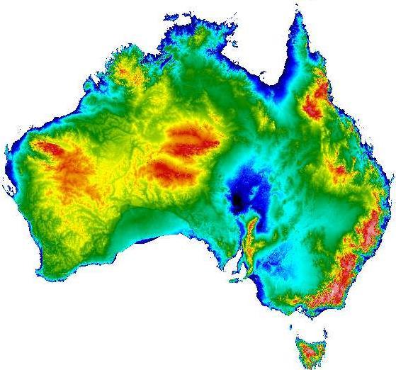
17 17
18 18
19 Your Job Make a list of the benefits of remote sensing Brainstorm a range of different possible applications and link them to the different benefits. For example: Benefit Large area coverage Application Continental scale vegetation mapping for Kyoto protocol compliance 19
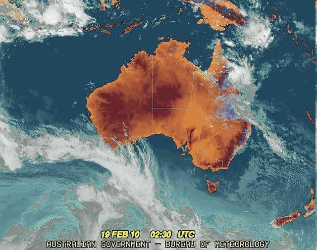
20 Weather Forecasting 20

21 Sea Surface Temperature 21

22 Ocean Colour and Vegetative Cover 22

23 Coral Cover 23
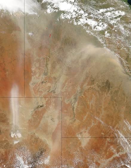
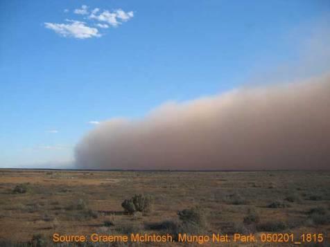
24 Dust SW Queensland 24
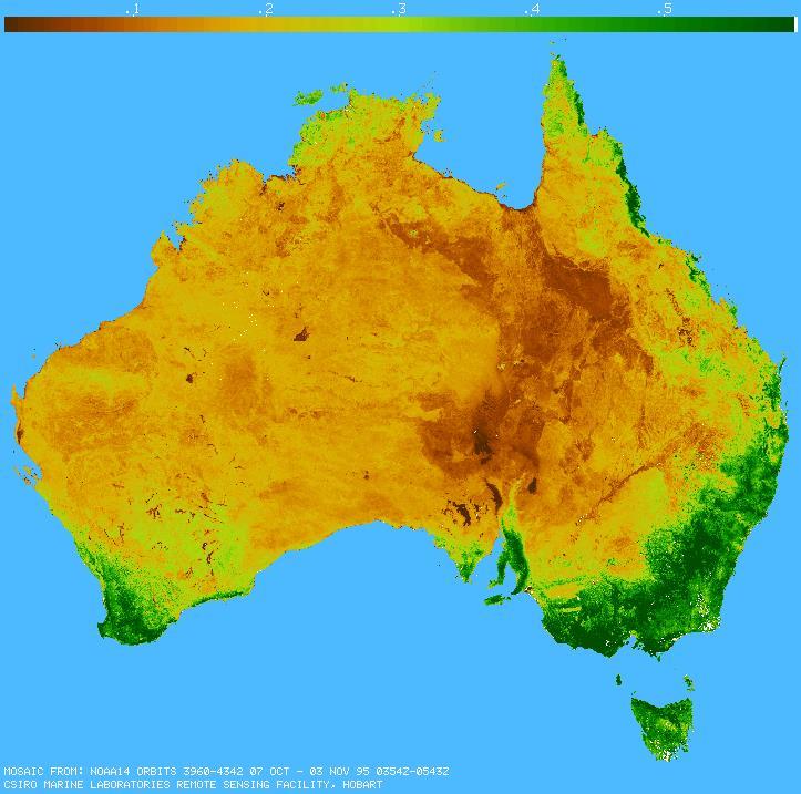
25 Vegetation Monitoring 25

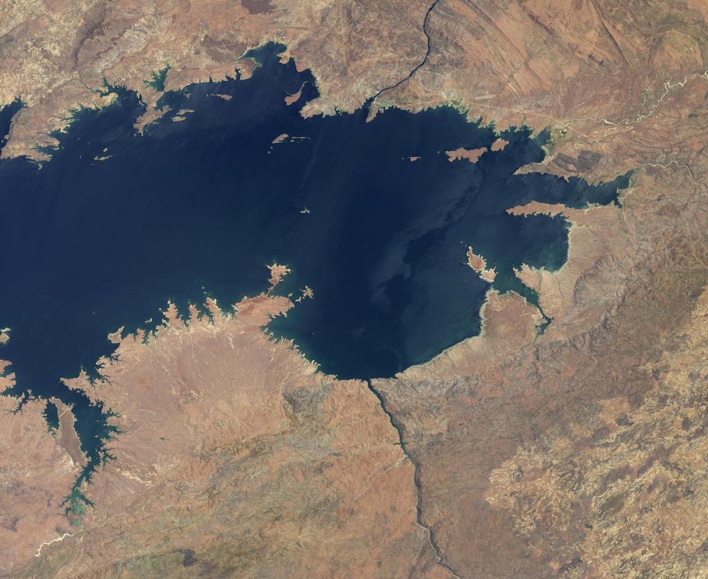
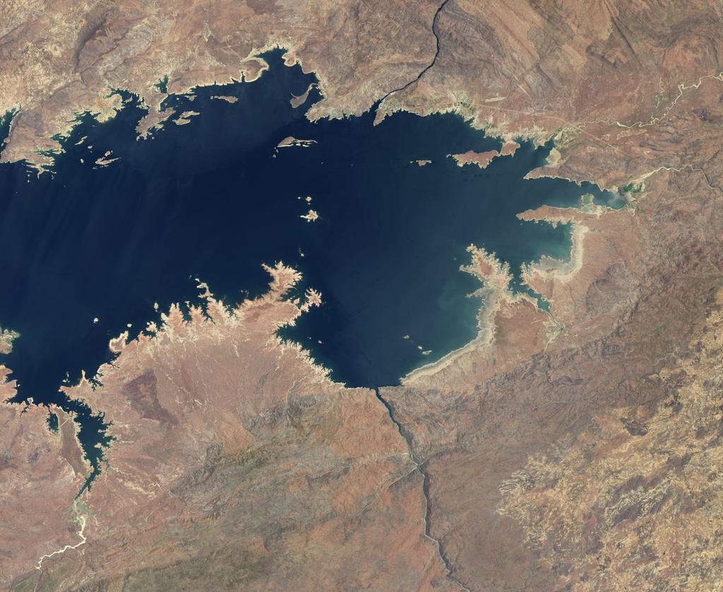
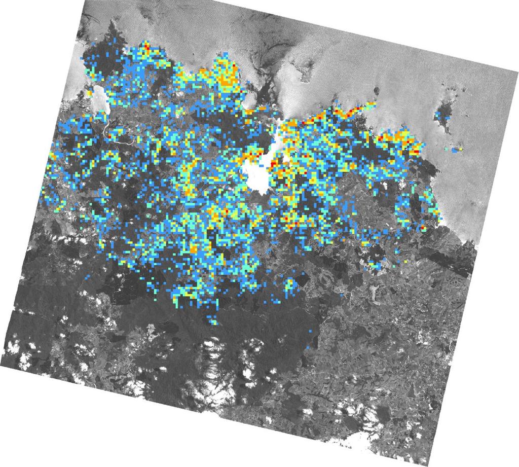
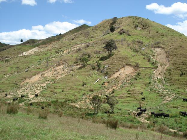
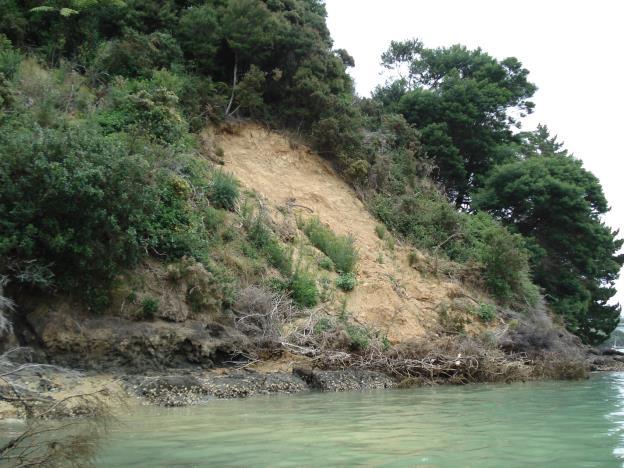
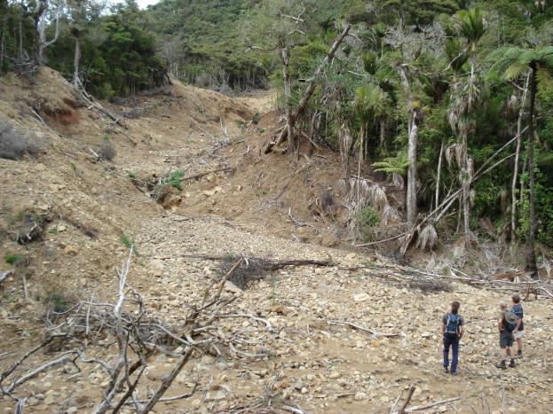
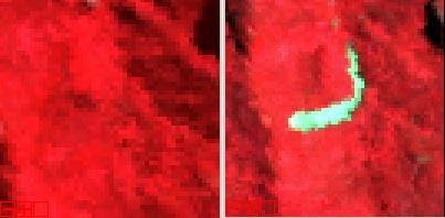
26 Digital Elevation / Bathymetry Models 26


27 Volcanic Eruptions Gas Emissions 27


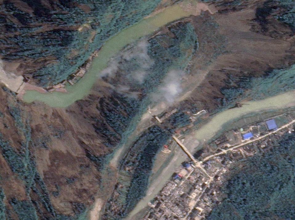
28 Volcanic Eruptions Hunga Tonga 500m 14 Nov Mar 09 Photos: NZAID 28


29 o Temperature ( C) Volcano Monitoring Temperature ASTER derived In-situ measured Mt Ruapehu Crater Lake Jul-07 Sep-07 Nov-07 Jan-08 Mar-08 May-08 Jul-08 Sep-08 Sample Date ASTER Thermal Imagery of Mt Ruapehu 3 Sep Sep Oct Nov Dec Dec Feb 08 5 Apr May Aug 08 5 Sep 08 29


30 Volcano Monitoring Lahar Mapping 9 Feb Mar 07 ASTER Imagery of Mt Ruapehu 30


31 Earthquakes and Deformations Source: S.Samsonov 31


32 Minerals and Geology 32
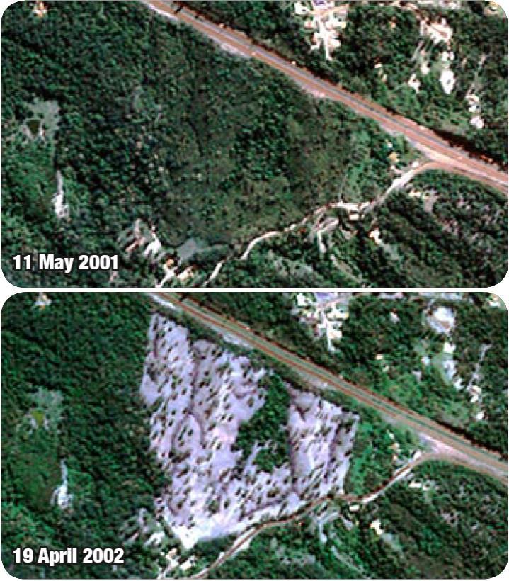
33 Number of landslides Counting Landslides BEFORE AFTER 33

34 1km GeoEye
35 35
36 Other Applications National Security Landcover / land use Infrastructure mapping Oil and gas Telecommunications Online mapping Personal navigation Construction, survey Agriculture Forestry Water resources Insurance Disaster relief Environmental monitoring 36
 First World War (1914 1918) Aerial scouting and reconnaissance The discipline of photogrammetry was established (1920 s)")
37 History of Remote Sensing US Army Balloon Corps, early 1860s Birth of photography (1839) Photography from Balloons ( ) Photography from aircraft (1909) First World War ( ) Aerial scouting and reconnaissance The discipline of photogrammetry was established (1920 s) 37
 Space Race - Rockets & Satellites (60 s and 70 s) Commercial (i.e. civilian) Satellites (July 72 to date) Digital image processing Boston, 1860 - taken from balloon 38")
38 History of Remote Sensing Radar developed (1930 s) Second World War ( ) Colour infra-red film used to detect camouflage The Cold War ( ) Colour infra-red photography used to detect crop disease The term remote sensing was first used (early 1960 s) Space Race - Rockets & Satellites (60 s and 70 s) Commercial (i.e. civilian) Satellites (July 72 to date) Digital image processing Boston, taken from balloon 38
 SLC failure 2003 Landsat 8 (2013 - ) High spatial resolution satellite imagery IKONOS (1999) & Quickbird (2001) First satellite hyper-spectral sensor EO-1 (2001) LiDAR Google Earth")
39 History of Remote Sensing Landsat 5 (1984) 29 years of operation - original intended mission only 3yrs! Landsat 7 (1999) SLC failure 2003 Landsat 8 ( ) High spatial resolution satellite imagery IKONOS (1999) & Quickbird (2001) First satellite hyper-spectral sensor EO-1 (2001) LiDAR Google Earth brings remote sensing to everyone with internet access (2005) Landsat archive freely available (2009) 39

 Sunlight is a form")


40 How Does Remote Sensing Work? Any object with a temperature > 0 o Kelvin emits electromagnetic radiation (EMR) Sunlight is a form of EMR Thermal energy (heat) is a form of EMR EMR from the sun is Reflected Transmitted Absorbed Reflected and/or emitted energy is recorded by a sensor 40


41 How Does Remote Sensing Work? 41

42 EMR Interactions Types of interactions observed in images are controlled by: Physical, Chemical and Biological characteristics of object; and Type of sensor 42

 Water Grasses etc Dense Veg Artificial")
43 From Images to Information Understanding EMR interactions with features of interest allows qualitative and quantitative analysis of images Maps are created by developing relationships between EMR (as recorded in an image) and features of interest (as measured on the ground) Water Grasses etc Dense Veg Artificial Surfaces 43
44 The Remote Sensing Process Source: Lillesand, Kiefer & Chipman (2008) 44

45 Satellites In Google Earth just go to "Add"->"Network Link" and paste link into the "Link:" field. coolstuff/my-satellitessensors.kml 45
46 Why Use Remote Sensing? Large area coverage Synoptic view, continuous spatial coverage Information about hard to access areas Use sensors to see in wavelengths not visible to human eye Make quantitative measurements about biogeophysical properties of earth s surface Digital record of features and processes Repeat coverage Cost (field vs. image) 46
47 Who uses remote sensing? Military Many Government Departments Commonwealth Agencies (CSIRO, ERISS, etc) City Councils NGOs United Nations Private industry (SKM, EWL, ERA etc) Universities and research agencies 47
 interactions Week 2 first practical Source: C.Roelfsema/S.")
48 No prac this week Coming Up Week 2 lecture: Understanding electromagnetic radiation (EMR) interactions Week 2 first practical Source: C.Roelfsema/S.Phinn 48
Geo/SAT 2 INTRODUCTION TO REMOTE SENSING
 Geo/SAT 2 INTRODUCTION TO REMOTE SENSING Paul R. Baumann, Professor Emeritus State University of New York College at Oneonta Oneonta, New York 13820 USA COPYRIGHT 2008 Paul R. Baumann Introduction Remote
Introduction to Remote Sensing
 Introduction to Remote Sensing Dr. Mathias (Mat) Disney UCL Geography Office: 301, 3rd Floor, Chandler House Tel: 7670 4290 Email: mdisney@ucl.geog.ac.uk www.geog.ucl.ac.uk/~mdisney 1 Course outline Format
The studies began when the Tiros satellites (1960) provided man s first synoptic view of the Earth s weather systems.
 provided man s first synoptic view of the Earth s weather systems.") Remote sensing of the Earth from orbital altitudes was recognized in the mid-1960 s as a potential technique for obtaining information important for the effective use and conservation of natural resources.
Remote sensing of the Earth from orbital altitudes was recognized in the mid-1960 s as a potential technique for obtaining information important for the effective use and conservation of natural resources.
Introduction to Remote Sensing
 Introduction to Remote Sensing Outline Remote Sensing Defined Resolution Electromagnetic Energy (EMR) Types Interpretation Applications Remote Sensing Defined Remote Sensing is: The art and science of
Introduction to Remote Sensing Fundamentals of Satellite Remote Sensing. Mads Olander Rasmussen
 Introduction to Remote Sensing Fundamentals of Satellite Remote Sensing Mads Olander Rasmussen (mora@dhi-gras.com) 01. Introduction to Remote Sensing DHI What is remote sensing? the art, science, and technology
Govt. Engineering College Jhalawar Model Question Paper Subject- Remote Sensing & GIS
 Govt. Engineering College Jhalawar Model Question Paper Subject- Remote Sensing & GIS Time: Max. Marks: Q1. What is remote Sensing? Explain the basic components of a Remote Sensing system. Q2. What is
INTRODUCTORY REMOTE SENSING. Geob 373
 INTRODUCTORY REMOTE SENSING Geob 373 Landsat 7 15 m image highlighting the geology of Oman http://www.satimagingcorp.com/gallery-landsat.html ASTER 15 m SWIR image, Escondida Mine, Chile http://www.satimagingcorp.com/satellite-sensors/aster.html
GIS Data Collection. Remote Sensing
 GIS Data Collection Remote Sensing Data Collection Remote sensing Introduction Concepts Spectral signatures Resolutions: spectral, spatial, temporal Digital image processing (classification) Other systems
Ghazanfar A. Khattak National Centre of Excellence in Geology University of Peshawar
 INTRODUCTION TO REMOTE SENSING Ghazanfar A. Khattak National Centre of Excellence in Geology University of Peshawar WHAT IS REMOTE SENSING? Remote sensing is the science of acquiring information about
Int n r t o r d o u d c u ti t on o n to t o Remote Sensing
 Introduction to Remote Sensing Definition of Remote Sensing Remote sensing refers to the activities of recording/observing/perceiving(sensing)objects or events at far away (remote) places. In remote sensing,
Satellite Imagery and Remote Sensing. DeeDee Whitaker SW Guilford High EES & Chemistry
 Satellite Imagery and Remote Sensing DeeDee Whitaker SW Guilford High EES & Chemistry whitakd@gcsnc.com Outline What is remote sensing? How does remote sensing work? What role does the electromagnetic
University of Wisconsin-Madison, Nelson Institute for Environmental Studies September 2, 2014
 University of Wisconsin-Madison, Nelson Institute for Environmental Studies September 2, 2014 The Earth from Above Introduction to Environmental Remote Sensing Lectures: Tuesday, Thursday 2:30-3:45 pm,
earthobservation.wordpress.com
 Dirty REMOTE SENSING earthobservation.wordpress.com Stuart Green Teagasc Stuart.Green@Teagasc.ie 1 Purpose Give you a very basic skill set and software training so you can: find free satellite image data.
An Introduction to Geomatics. Prepared by: Dr. Maher A. El-Hallaq خاص بطلبة مساق مقدمة في علم. Associate Professor of Surveying IUG
 An Introduction to Geomatics خاص بطلبة مساق مقدمة في علم الجيوماتكس Prepared by: Dr. Maher A. El-Hallaq Associate Professor of Surveying IUG 1 Airborne Imagery Dr. Maher A. El-Hallaq Associate Professor
Introduction to Remote Sensing
 Introduction to Remote Sensing Spatial, spectral, temporal resolutions Image display alternatives Vegetation Indices Image classifications Image change detections Accuracy assessment Satellites & Air-Photos
Introduction of Satellite Remote Sensing
 Introduction of Satellite Remote Sensing Spatial Resolution (Pixel size) Spectral Resolution (Bands) Resolutions of Remote Sensing 1. Spatial (what area and how detailed) 2. Spectral (what colors bands)
746A27 Remote Sensing and GIS
 746A27 Remote Sensing and GIS Lecture 1 Concepts of remote sensing and Basic principle of Photogrammetry Chandan Roy Guest Lecturer Department of Computer and Information Science Linköping University What
Blacksburg, VA July 24 th 30 th, 2010 Remote Sensing Page 1. A condensed overview. For our purposes
 A condensed overview George McLeod Prepared by: With support from: NSF DUE-0903270 in partnership with: Geospatial Technician Education Through Virginia s Community Colleges (GTEVCC) The art and science
Introduction to Remote Sensing
 Introduction to Remote Sensing Daniel McInerney Urban Institute Ireland, University College Dublin, Richview Campus, Clonskeagh Drive, Dublin 14. 16th June 2009 Presentation Outline 1 2 Spaceborne Sensors
Using Freely Available. Remote Sensing to Create a More Powerful GIS
 Using Freely Available Government Data and Remote Sensing to Create a More Powerful GIS All rights reserved. ENVI, E3De, IAS, and IDL are trademarks of Exelis, Inc. All other marks are the property of
Outline for today. Geography 411/611 Remote sensing: Principles and Applications. Remote sensing: RS for biogeochemical cycles
 Geography 411/611 Remote sensing: Principles and Applications Thomas Albright, Associate Professor Laboratory for Conservation Biogeography, Department of Geography & Program in Ecology, Evolution, & Conservation
Monitoring agricultural plantations with remote sensing imagery
 MPRA Munich Personal RePEc Archive Monitoring agricultural plantations with remote sensing imagery Camelia Slave and Anca Rotman University of Agronomic Sciences and Veterinary Medicine - Bucharest Romania,
Image interpretation. Aliens create Indian Head with an ipod? Badlands Guardian (CBC) This feature can be found 300 KMs SE of Calgary.
 This feature can be found 300 KMs SE of Calgary.") Image interpretation Aliens create Indian Head with an ipod? Badlands Guardian (CBC) This feature can be found 300 KMs SE of Calgary. 50 1 N 110 7 W Milestones in the History of Remote Sensing 19 th century
Image interpretation Aliens create Indian Head with an ipod? Badlands Guardian (CBC) This feature can be found 300 KMs SE of Calgary. 50 1 N 110 7 W Milestones in the History of Remote Sensing 19 th century
Sommersemester Prof. Dr. Christoph Kleinn Institut für Waldinventur und Waldwachstum Arbeitsbereich Fernerkundung und Waldinventur.
 Basics of Remote Sensing Some literature references Franklin, SE 2001 Remote Sensing for Sustainable Forest Management Lewis Publishers 407p Lillesand, Kiefer 2000 Remote Sensing and Image Interpretation
An Introduction to Remote Sensing & GIS. Introduction
 An Introduction to Remote Sensing & GIS Introduction Remote sensing is the measurement of object properties on Earth s surface using data acquired from aircraft and satellites. It attempts to measure something
9/12/2011. Training Course Remote Sensing Basic Theory & Image Processing Methods September 2011
 Training Course Remote Sensing Basic Theory & Image Processing Methods 19 23 September 2011 Introduction to Remote Sensing Michiel Damen (September 2011) damen@itc.nl 1 Overview Some definitions Remote
Outline Remote Sensing Defined Resolution Electromagnetic Energy (EMR) Types Interpretation Applications
 Types Interpretation Applications") Introduction to Remote Sensing Outline Remote Sensing Defined Resolution Electromagnetic Energy (EMR) Types Interpretation Applications Remote Sensing Defined Remote Sensing is: The art and science of
Introduction to Remote Sensing Outline Remote Sensing Defined Resolution Electromagnetic Energy (EMR) Types Interpretation Applications Remote Sensing Defined Remote Sensing is: The art and science of
Lecture 13: Remotely Sensed Geospatial Data
 Lecture 13: Remotely Sensed Geospatial Data A. The Electromagnetic Spectrum: The electromagnetic spectrum (Figure 1) indicates the different forms of radiation (or simply stated light) emitted by nature.
to Geospatial Technologies
 What s in a Pixel? A Primer for Remote Sensing What s in a Pixel Development UNH Cooperative Extension Geospatial Technologies Training Center Shane Bradt UConn Cooperative Extension Geospatial Technology
remote sensing? What are the remote sensing principles behind these Definition
 Introduction to remote sensing: Content (1/2) Definition: photogrammetry and remote sensing (PRS) Radiation sources: solar radiation (passive optical RS) earth emission (passive microwave or thermal infrared
First Exam: New Date. 7 Geographers Tools: Gathering Information. Photographs and Imagery REMOTE SENSING 2/23/2018. Friday, March 2, 2018.
 First Exam: New Date Friday, March 2, 2018. Combination of multiple choice questions and map interpretation. Bring a #2 pencil with eraser. Based on class lectures supplementing chapter 1. Review lecture
UNERSITY OF NAIROBI UNIT: PRICIPLES AND APPLICATIONS OF REMOTE SENSING AND APLLIED CLIMATOLOGY
 UNERSITY OF NAIROBI DEPARTMENT OF METEOROLOGY UNIT: PRICIPLES AND APPLICATIONS OF REMOTE SENSING AND APLLIED CLIMATOLOGY COURSE CODE: SMR 308 GROUP TWO: SENSORS MEMBERS OF GROUP TWO 1. MUTISYA J.M I10/2784/2006
Chapter 8. Remote sensing
 1. Remote sensing 8.1 Introduction 8.2 Remote sensing 8.3 Resolution 8.4 Landsat 8.5 Geostationary satellites GOES 8.1 Introduction What is remote sensing? One can describe remote sensing in different
Lecture 6: Multispectral Earth Resource Satellites. The University at Albany Fall 2018 Geography and Planning
 Lecture 6: Multispectral Earth Resource Satellites The University at Albany Fall 2018 Geography and Planning Outline SPOT program and other moderate resolution systems High resolution satellite systems
Interpreting land surface features. SWAC module 3
 Interpreting land surface features SWAC module 3 Interpreting land surface features SWAC module 3 Different kinds of image Panchromatic image True-color image False-color image EMR : NASA Echo the bat
First Exam: Thurs., Sept 28
 8 Geographers Tools: Gathering Information Prof. Anthony Grande Hunter College Geography Lecture design, content and presentation AFG 0917. Individual images and illustrations may be subject to prior copyright.
GGS 412 Air Photography Interpretation
 GGS 412 Air Photography Interpretation 15019-001 Syllabus Instructor: Dr. Ron Resmini Course description and objective: GGS 412, Air Photography Interpretation, will provide students with the concepts,
Remote Sensing and GIS
 Remote Sensing and GIS Atmosphere Reflected radiation, e.g. Visible Emitted radiation, e.g. Infrared Backscattered radiation, e.g. Radar (λ) Visible TIR Radar & Microwave 11/9/2017 Geo327G/386G, U Texas,
Outline Remote Sensing Defined Resolution Electromagnetic Energy (EMR) Types Interpretation Applications 2
 Types Interpretation Applications 2") Introduction to Remote Sensing 1 Outline Remote Sensing Defined Resolution Electromagnetic Energy (EMR) Types Interpretation Applications 2 Remote Sensing Defined Remote Sensing is: The art and science
Introduction to Remote Sensing 1 Outline Remote Sensing Defined Resolution Electromagnetic Energy (EMR) Types Interpretation Applications 2 Remote Sensing Defined Remote Sensing is: The art and science
Remote Sensing Platforms
 Types of Platforms Lighter-than-air Remote Sensing Platforms Free floating balloons Restricted by atmospheric conditions Used to acquire meteorological/atmospheric data Blimps/dirigibles Major role - news
First Exam. Geographers Tools: Gathering Information. Photographs and Imagery. SPIN 2 Image of Downtown Atlanta, GA 1995 REMOTE SENSING 9/19/2016
 First Exam Geographers Tools: Gathering Information Prof. Anthony Grande Hunter College Geography Lecture design, content and presentation AFG 0616. Individual images and illustrations may be subject to
How to Access Imagery and Carry Out Remote Sensing Analysis Using Landsat Data in a Browser
 How to Access Imagery and Carry Out Remote Sensing Analysis Using Landsat Data in a Browser Including Introduction to Remote Sensing Concepts Based on: igett Remote Sensing Concept Modules and GeoTech
Remote Sensing 1 Principles of visible and radar remote sensing & sensors
 Remote Sensing 1 Principles of visible and radar remote sensing & sensors Nick Barrand School of Geography, Earth & Environmental Sciences University of Birmingham, UK Field glaciologist collecting data
Some Basic Concepts of Remote Sensing. Lecture 2 August 31, 2005
 Some Basic Concepts of Remote Sensing Lecture 2 August 31, 2005 What is remote sensing Remote Sensing: remote sensing is science of acquiring, processing, and interpreting images and related data that
Important Missions. weather forecasting and monitoring communication navigation military earth resource observation LANDSAT SEASAT SPOT IRS
 Fundamentals of Remote Sensing Pranjit Kr. Sarma, Ph.D. Assistant Professor Department of Geography Mangaldai College Email: prangis@gmail.com Ph. No +91 94357 04398 Remote Sensing Remote sensing is defined
Lecture Series SGL 308: Introduction to Geological Mapping Lecture 8 LECTURE 8 REMOTE SENSING METHODS: THE USE AND INTERPRETATION OF SATELLITE IMAGES
 LECTURE 8 REMOTE SENSING METHODS: THE USE AND INTERPRETATION OF SATELLITE IMAGES LECTURE OUTLINE Page 8.0 Introduction 114 8.1 Objectives 115 115 8.2 Remote Sensing: Method of Operation 8.3 Importance
A (very) brief introduction to Remote Sensing: From satellites to maps!
 brief introduction to Remote Sensing: From satellites to maps!") Spatial Data Analysis and Modeling for Agricultural Development, with R - Workshop A (very) brief introduction to Remote Sensing: From satellites to maps! Earthlights DMSP 1994-1995 https://wikimedia.org/
Spatial Data Analysis and Modeling for Agricultural Development, with R - Workshop A (very) brief introduction to Remote Sensing: From satellites to maps! Earthlights DMSP 1994-1995 https://wikimedia.org/
Remote sensing in archaeology from optical to lidar. Krištof Oštir ModeLTER Scientific Research Centre of the Slovenian Academy of Sciences and Arts
 Remote sensing in archaeology from optical to lidar Krištof Oštir ModeLTER Scientific Research Centre of the Slovenian Academy of Sciences and Arts Introduction Optical remote sensing Systems Search for
Remote Sensing. in Agriculture. Dr. Baqer Ramadhan CRP 514 Geographic Information System. Adel M. Al-Rebh G Term Paper.
 Remote Sensing in Agriculture Term Paper to Dr. Baqer Ramadhan CRP 514 Geographic Information System By Adel M. Al-Rebh G199325390 May 2012 Table of Contents 1.0 Introduction... 4 2.0 Objective... 4 3.0
The studies began when the Tiros satellites (1960) provided man s first synoptic view of the Earth s weather systems.
 provided man s first synoptic view of the Earth s weather systems.") Remote sensing of the Earth from orbital altitudes was recognized in the mid-1960 s as a potential technique for obtaining information important for the effective use and conservation of natural resources.
Remote sensing of the Earth from orbital altitudes was recognized in the mid-1960 s as a potential technique for obtaining information important for the effective use and conservation of natural resources.
HISTORY OF REMOTE SENSING
 HISTORY OF REMOTE SENSING IMPORTANT PERIODS The beginning: photography and flight (1858-1918) Rapid developments in photogrammetry (1918-1939) Military imperatives (1939-1945) Cold wars and environmental
Introduction to Remote Sensing
 Introduction to Remote Sensing 1 Outline Remote Sensing Defined Electromagnetic Energy (EMR) Resolution Interpretation 2 Remote Sensing Defined Remote Sensing is: The art and science of obtaining information
Aerial photography and Remote Sensing. Bikini Atoll, 2013 (60 years after nuclear bomb testing)
") Aerial photography and Remote Sensing Bikini Atoll, 2013 (60 years after nuclear bomb testing) Computers have linked mapping techniques under the umbrella term : Geomatics includes all the following spatial
Aerial photography and Remote Sensing Bikini Atoll, 2013 (60 years after nuclear bomb testing) Computers have linked mapping techniques under the umbrella term : Geomatics includes all the following spatial
Remote Sensing for Rangeland Applications
 Remote Sensing for Rangeland Applications Jay Angerer Ecological Training June 16, 2012 Remote Sensing The term "remote sensing," first used in the United States in the 1950s by Ms. Evelyn Pruitt of the
Module 3 Introduction to GIS. Lecture 8 GIS data acquisition
 Module 3 Introduction to GIS Lecture 8 GIS data acquisition GIS workflow Data acquisition (geospatial data input) GPS Remote sensing (satellites, UAV s) LiDAR Digitized maps Attribute Data Management Data
7 Geographers Tools: Gathering Information
 FIRST EXAM TODAY ExCr ATLAS EXERCISE for EXAM I is DUE. Bubble in your vtues., Feb. 26, 2019. Pass Scantrons forward. name on the back. Combination of multiple choice questions and map interpretation.
Remote Sensing Platforms
 Remote Sensing Platforms Remote Sensing Platforms - Introduction Allow observer and/or sensor to be above the target/phenomena of interest Two primary categories Aircraft Spacecraft Each type offers different
Introduction to Remote Sensing of the Environment. Dr. Anne Nolin Department of Geosciences
 Introduction to Remote Sensing of the Environment Dr. Anne Nolin Department of Geosciences Overview of today s lecture Course overview Definitions How measurements are made Analog vs. digital The remote
1. Theory of remote sensing and spectrum
 1. Theory of remote sensing and spectrum 7 August 2014 ONUMA Takumi Outline of Presentation Electromagnetic wave and wavelength Sensor type Spectrum Spatial resolution Spectral resolution Mineral mapping
Lesson 3: Working with Landsat Data
 Lesson 3: Working with Landsat Data Lesson Description The Landsat Program is the longest-running and most extensive collection of satellite imagery for Earth. These datasets are global in scale, continuously
SAR Multi-Temporal Applications
 SAR Multi-Temporal Applications 83230359-DOC-TAS-EN-001 Contents 2 Advantages of SAR Remote Sensing Technology All weather any time Frequencies and polarisations Interferometry and 3D mapping Change Detection
NRS 415 Remote Sensing of Environment
 NRS 415 Remote Sensing of Environment 1 High Oblique Perspective (Side) Low Oblique Perspective (Relief) 2 Aerial Perspective (See What s Hidden) An example of high spatial resolution true color remote
Environmental and Natural Resources Issues in Minnesota. A Remote Sensing Overview: Principles and Fundamentals. Outline. Challenges.
 A Remote Sensing Overview: Principles and Fundamentals Marvin Bauer Remote Sensing and Geospatial Analysis Laboratory College of Natural Resources University of Minnesota Remote Sensing for GIS Users Workshop,
REMOTE SENSING. Topic 10 Fundamentals of Digital Multispectral Remote Sensing MULTISPECTRAL SCANNERS MULTISPECTRAL SCANNERS
 REMOTE SENSING Topic 10 Fundamentals of Digital Multispectral Remote Sensing Chapter 5: Lillesand and Keifer Chapter 6: Avery and Berlin MULTISPECTRAL SCANNERS Record EMR in a number of discrete portions
FOR 353: Air Photo Interpretation and Photogrammetry. Lecture 2. Electromagnetic Energy/Camera and Film characteristics
 FOR 353: Air Photo Interpretation and Photogrammetry Lecture 2 Electromagnetic Energy/Camera and Film characteristics Lecture Outline Electromagnetic Radiation Theory Digital vs. Analog (i.e. film ) Systems
9/13/2011. Training Course Remote Sensing Basic Theory & Image Processing Methods September 2011
 Training Course Remote Sensing Basic Theory & Image Processing Methods 19 23 September 2011 DIGITAL TERRAIN MODELS Introduction Michiel Damen (April 2011) damen@itc.nl 1 Digital Elevation and Terrain Models
(Refer Slide Time: 1:20)
") Introduction to Remote Sensing Dr. Arun K Saraf Department of Earth Sciences Indian Institute of Technology Roorkee Lecture 02 Development of Remote Sensing Technology & Advantages Hello! This is second
Introduction to Remote Sensing Dr. Arun K Saraf Department of Earth Sciences Indian Institute of Technology Roorkee Lecture 02 Development of Remote Sensing Technology & Advantages Hello! This is second
FOR 474: Forest Inventory. FOR 474: Forest Inventory. Why do we Care About Forest Sampling?
 FOR 474: Forest Inventory 1. Advanced Forest Inventory The Need for Forest Sampling Brief Intro to Remote Sensing and GIS Readings: FOR 474: Forest Inventory Related Courses! FOR 274: Forest Measurements
Final Examination Introduction to Remote Sensing. Time: 1.5 hrs Max. Marks: 50. Section-I (50 x 1 = 50 Marks)
") Final Examination Introduction to Remote Sensing Time: 1.5 hrs Max. Marks: 50 Note: Attempt all questions. Section-I (50 x 1 = 50 Marks) 1... is the technology of acquiring information about the Earth's
Final Examination Introduction to Remote Sensing Time: 1.5 hrs Max. Marks: 50 Note: Attempt all questions. Section-I (50 x 1 = 50 Marks) 1... is the technology of acquiring information about the Earth's
Futrajaya, Malaysia JULY 12, Jeong Heon SONG. Korea Aerospace Research Institution
 J P T M 2 0 1 1 Futrajaya, Malaysia JULY 12, 2011 Jeong Heon SONG Korea Aerospace Research Institution Outline Contribution of KARI Sentinel Asia / Data Provider Node International Charter KARI Space Activities
John P. Stevens HS: Remote Sensing Test
 Name(s): Date: Team name: John P. Stevens HS: Remote Sensing Test 1 Scoring: Part I - /18 Part II - /40 Part III - /16 Part IV - /14 Part V - /93 Total: /181 2 I. History (3 pts. each) 1. What is the name
Remote Sensing. Measuring an object from a distance. For GIS, that means using photographic or satellite images to gather spatial data
 Remote Sensing Measuring an object from a distance For GIS, that means using photographic or satellite images to gather spatial data Remote Sensing measures electromagnetic energy reflected or emitted
INTRODUCTION TO REMOTE SENSING AND ITS APPLICATIONS
 INTRODUCTION TO REMOTE SENSING AND ITS APPLICATIONS Prof. Dr. Abudeif A. Bakheit Geology Department. Faculty of Science Assiut University This representation was prepared from different power point representations
HYPERSPECTRAL IMAGERY FOR SAFEGUARDS APPLICATIONS. International Atomic Energy Agency, Vienna, Austria
 HYPERSPECTRAL IMAGERY FOR SAFEGUARDS APPLICATIONS G. A. Borstad 1, Leslie N. Brown 1, Q.S. Bob Truong 2, R. Kelley, 3 G. Healey, 3 J.-P. Paquette, 3 K. Staenz 4, and R. Neville 4 1 Borstad Associates Ltd.,
Digital Image Processing - A Remote Sensing Perspective
 ISSN 2278 0211 (Online) Digital Image Processing - A Remote Sensing Perspective D.Sarala Department of Physics & Electronics St. Ann s College for Women, Mehdipatnam, Hyderabad, India Sunita Jacob Head,
3/31/03. ESM 266: Introduction 1. Observations from space. Remote Sensing: The Major Source for Large-Scale Environmental Information
 Remote Sensing: The Major Source for Large-Scale Environmental Information Jeff Dozier Observations from space Sun-synchronous polar orbits Global coverage, fixed crossing, repeat sampling Typical altitude
Remote Sensing is the observation of the Earth from satellites or aircrafts.
 Remote Sensing? Remote Sensing is the observation of the Earth from satellites or aircrafts. Sensors mounted on these platforms capture images of the Earth that reveal features may or may not apparent
Part I. The Importance of Image Registration for Remote Sensing
 Part I The Importance of Image Registration for Remote Sensing 1 Introduction jacqueline le moigne, nathan s. netanyahu, and roger d. eastman Despite the importance of image registration to data integration
Remote sensing radio applications/ systems for environmental monitoring
 Remote sensing radio applications/ systems for environmental monitoring Alexandre VASSILIEV ITU Radiocommunication Bureau phone: +41 22 7305924 e-mail: alexandre.vassiliev@itu.int 1 Source: European Space
SFR 406 Remote Sensing, Image Interpretation, and Forest Mapping Spring Semester 2015
 SFR 406 Remote Sensing, Image Interpretation, and Forest Mapping Spring Semester 2015 Course Description: Vertical and horizontal measurements from aerial photos, orthophotos, and topographic maps. Fundamentals
Sources of Geographic Information
 Sources of Geographic Information Data properties: Spatial data, i.e. data that are associated with geographic locations Data format: digital (analog data for traditional paper maps) Data Inputs: sampled
Introduction to Remote Sensors and Image Processing and its Applications
 Introduction to Remote Sensors and Image Processing and its Applications A. A. Daptardar, Senior Lecturer Department of Computer Science and Engineering Hirasugar Institute Of Technology, Nidasoshi, Karnataka,
Photogrammetry. Lecture 4 September 7, 2005
 Photogrammetry Lecture 4 September 7, 2005 What is Photogrammetry Photogrammetry is the art and science of making accurate measurements by means of aerial photography: Analog photogrammetry (using films:
A broad survey of remote sensing applications for many environmental disciplines
 1 2 3 4 A broad survey of remote sensing applications for many environmental disciplines 5 6 7 8 9 10 1. First definition is very general and applies to many types of remote sensing. You use your eyes
Application of Remote Sensing in the Monitoring of Marine pollution. By Atif Shahzad Institute of Environmental Studies University of Karachi
 Application of Remote Sensing in the Monitoring of Marine pollution By Atif Shahzad Institute of Environmental Studies University of Karachi Remote Sensing "Remote sensing is the science (and to some extent,
Active and Passive Microwave Remote Sensing
 Active and Passive Microwave Remote Sensing Passive remote sensing system record EMR that was reflected (e.g., blue, green, red, and near IR) or emitted (e.g., thermal IR) from the surface of the Earth.
Application of Satellite Remote Sensing for Natural Disasters Observation
 Application of Satellite Remote Sensing for Natural Disasters Observation Prof. Krištof Oštir, Ph.D. University of Ljubljana Faculty of Civil and Geodetic Engineering Outline Earth observation current
Bridge Condition Assessment Using Remote Sensors
 A Summary of the 4th Quarterly Report for the Technical Activities Council Bridge Condition Assessment Using Remote Sensors Michigan Technological University USDOT Cooperative Agreement No. DTOS59-10-H-00001
Application of GIS to Fast Track Planning and Monitoring of Development Agenda
 Application of GIS to Fast Track Planning and Monitoring of Development Agenda Radiometric, Atmospheric & Geometric Preprocessing of Optical Remote Sensing 13 17 June 2018 Outline 1. Why pre-process remotely
Sources of Geographic Information
 Sources of Geographic Information Data properties: Spatial data, i.e. data that are associated with geographic locations Data format: digital (analog data for traditional paper maps) Data Inputs: sampled
Remote Sensing. Odyssey 7 Jun 2012 Benjamin Post
 Remote Sensing Odyssey 7 Jun 2012 Benjamin Post Definitions Applications Physics Image Processing Classifiers Ancillary Data Data Sources Related Concepts Outline Big Picture Definitions Remote Sensing
CHARACTERISTICS OF REMOTELY SENSED IMAGERY. Radiometric Resolution
 CHARACTERISTICS OF REMOTELY SENSED IMAGERY Radiometric Resolution There are a number of ways in which images can differ. One set of important differences relate to the various resolutions that images express.
9/12/2011. Training Course Remote Sensing Basic Theory & Image Processing Methods September 2011
 Training Course Remote Sensing Basic Theory & Image Processing Methods 19 23 September 2011 Popular Remote Sensing Sensors & their Selection Michiel Damen (September 2011) damen@itc.nl 1 Overview Low resolution
SATELLITE OCEANOGRAPHY
 SATELLITE OCEANOGRAPHY An Introduction for Oceanographers and Remote-sensing Scientists I. S. Robinson Lecturer in Physical Oceanography Department of Oceanography University of Southampton JOHN WILEY
The use of satellite images to forecast agricultural
 The use of satellite images to forecast agricultural Luxembourg, 12.03.2014 r. Tomasz Milewski NUTS for Poland: NUTS 1 macro-regions (grup of province, voivodships) (6), NUTS 2 - regions (province,
REMOTE SENSING INTERPRETATION
 REMOTE SENSING INTERPRETATION Jan Clevers Centre for Geo-Information - WU Remote Sensing --> RS Sensor at a distance EARTH OBSERVATION EM energy Earth RS is a tool; one of the sources of information! 1
JP Stevens High School: Remote Sensing
 1 Name(s): ANSWER KEY Date: Team name: JP Stevens High School: Remote Sensing Scoring: Part I - /18 Part II - /40 Part III - /16 Part IV - /14 Part V - /93 Total: /181 2 I. History (3 pts each) 1. What
Microwave Remote Sensing
 Provide copy on a CD of the UCAR multi-media tutorial to all in class. Assign Ch-7 and Ch-9 (for two weeks) as reading material for this class. HW#4 (Due in two weeks) Problems 1,2,3 and 4 (Chapter 7)
ACTIVE SENSORS RADAR
 ACTIVE SENSORS RADAR RADAR LiDAR: Light Detection And Ranging RADAR: RAdio Detection And Ranging SONAR: SOund Navigation And Ranging Used to image the ocean floor (produce bathymetic maps) and detect objects
Application and potentials of RADAR and LiDAR technologies for forest carbon assessment in Pacific Island Countries
 Application and potentials of RADAR and LiDAR technologies for forest carbon assessment in Pacific Island Countries June 19th, 2012 PNGFA-JICA Workshop Masamichi HARAGUCHI (Kokusai Kogyo Co., Ltd.) Consultant