Remote Sensing. Odyssey 7 Jun 2012 Benjamin Post
|
|
|
- Elaine Freeman
- 6 years ago
- Views:
Transcription
1 Remote Sensing Odyssey 7 Jun 2012 Benjamin Post
2 Definitions Applications Physics Image Processing Classifiers Ancillary Data Data Sources Related Concepts Outline

3 Big Picture
4 Definitions
5 Remote Sensing Remote Sensing is the collection of information about an object without having physical contact with the object Traditionally regarded as the use of satellites that collect information about the Earth and its environment. Other applications: i.e. microscope, MRIs, etc Both passive and active
6 Resolutions Spatial How many meters per pixel? Radiometric How many bits store the recorded spectral information? Typically 8 bits, some platforms have 12 bits Temporal How often is the data collected Combination of spatial resolution and platform capabilities Landsat ~ every 16 days Spectral What bands of information are collected? Important to know both the spectral signature of object in question and the spectral bands of the platform. Landsat 5 ER bands, 1-2 thermal bands.
 light, and always includes one NIR band Bands are typically an average of intensities captured in a range of")
7 Multispectral Multispectral imagery captures multiple bands of spectral wavelengths Typically 4-8 bands of information Usually includes visible (BGR) light, and always includes one NIR band Bands are typically an average of intensities captured in a range of wavelength
8 Applications


9 Vegetation Monitoring Forestry Canopy structure/height Leaf Area Index Biomass Agriculture Crop yield predictions Soil moisture Crop disease


10 Atmosphere Aerosols / Ozone Clouds Precipitation Water Algae growth / Chlorophyll Sediment Temperature Surface Moisture Mineral composition Temperature Environment


11 Land Use Commercial, residential, transportation, etc. Tax mapping Land Cover NLCD is derived from Landsat imagery Pollution detection and monitoring Bodies of water Disaster assessment BWCA blowdown/fire, Katrina Administrative
12 Physics
 energy is proportional to")
13 Basics Governed by the laws of Electromagnetic Radiation (ER) Particle and wave theory apply c = f * λ Frequency is inversely proportional to wavelength E = h * f = h * c / λ Photon s (AKA Quanta) energy is proportional to frequency

14 ER Spectrum
15 Interaction When ER comes in contact with an object, 4 possibilities occur: Reflected Absorbed Transmitted Refracted (Atmospheric, usually ignored) Energy Balance Incident E = Reflected + Absorbed + Transmitted
16 Reflection Main source of RS information, as this ER is what is being collected by the sensor. Gives an object its color. In imagery, gives a higher digital number (DN) Two types of reflector surfaces to consider
17 Absorption Another key source of RS information In imagery, this produces smaller DN values Atmospheric molecules (H₂O, CO₂, O₃) absorb and scatter specific wavelengths, leaving behind Atmospheric Windows suitable for RS Water completely absorbs near infrared (NIR) Impervious surfaces absorb NIR, then emit energy as thermal IR that can be detected.
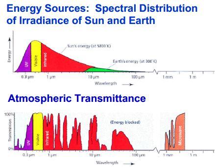
18 Atmospheric Window
19 Transmittance Not as important as absorption and reflection, but a present phenomena Some of the ER passes through the object and can be reflected/absorbed by underlying objects Major uses Measuring tree canopy density using NIR Mapping sea floors using bathymetry
20 Refraction/Scattering Introduces error/noise in the resulting image Scattering occurs when light particles interact with atmospheric particles Rayleigh: the blue bands are scattered in the atmosphere Mie: Haze Non-selective: Dust Usually accounted for and not much of a concern for general classification of imagery.

21 Remote Sensing Equation
22 Image Processing
23 Image Processing Image Correction Compensates for distortion, errors, and noise Image Enhancement Improves or increases visual appearance/quality Information Extraction Classification of pixels based on spectral response
24 Image Correction Geometric Corrections Parametric fixes systematic errors Scan skew Mirror and platform velocity variations Perspective geometry Non-Parametric Establishes mathematical relationships between coordinates of pixels and ground control points. Involves both Rectification and Resampling
25 Rectification We know how this works, but how do we tell if it is accurate? We calculate the Root Mean Square (RMS) error of the differences between the map and image. RMS = SQRT((X X orig ) 2 + (Y Y orig ) 2 ) Acceptable RMS error <=.5 pixel So for z15, this would represent ~ 2.3m error
26 Resampling Nearest Neighbor Least precise in terms of placement, but preserves the original radiometry Bilinear Interpolation Smooth image by averaging the 4 closest pixels Cubic Convolution Smooth image by averaging the (16, 25, 36) closest pixels. Produces the sharpest image In RS, always want to preserve radiometry
27 Image Enhancement Processing or transformation of an image to make information extraction easier or more accurate Fall into 2 categories Spectral Radiometric Enhancement Designed to accentuate contrast between information classes at a per pixel level Spatial Enhancement Uses area/neighborhood operations to determine new pixel value Convolution Filters (High/Low Pass)
28 Spectral-Radiometric Enhancements Contrast Stretching Distributes the DN values to a larger range of output values.
29 Spectral-Radiometric Enhancements Principle Components Shows the correlation between 2 or more bands of information Useful in suburban areas, where there are many mixed pixels and a lot of variance. A summary of how it works wouldn t do it justice here, if you are interested read up on it
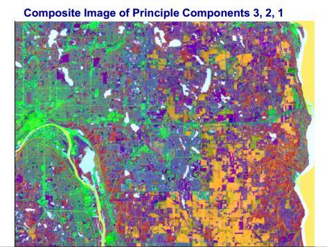
30 Principle Components

31 Spectral-Radiometric Enhancements Spectral Band Ratios Used to accentuate differential spectral responses in 2 bands AND normalizes unwanted effects. NDVI (IR red) / (IR + red) most common
32 Pan Sharpening Panchromatic images are often higher resolution, but black and white Landsat: Pan 15mpp, Bands 30mpp IKONOS: Pan 1mpp, Bands 4mpp Pan sharpening ties the colored bands to the pixels from a panchromatic image Resulting image is not as accurate as information captured in that resolution
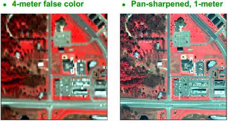
33 Pan Sharpening
34 Classifiers
35 Before we dive in Careful consideration must be given to the class types and number of classes we want to extract from the imagery. Classes should be Mutually Exclusive Exhaustive Hierarchical The overall goal is to minimize the differences within a class, and to maximize the differences between classes.
36 Classifiers Hard Classifier Boolean, you re in or you re out. Soft Classifier Uses a membership vector to determine classification
37 Hard Classifiers - Unsupervised Uses cluster analysis to group natural clusters of similar brightness from multispectral image The clusters are not yet classified, the user must go through and apply the classification scheme ISODATA is most common algorithm Advantages: Quick and easy to classify depending on GIS platform Requires no previous knowledge of area being extracted Disadvantages: Number of classes greatly affects clustering accuracy Exact number only found using trial and error
38 Hard Classifiers - Supervised Parallelpiped Bounding box around class clusters Quick, considers variance but insensitive to boundary overlap Minimum Distance Measures Euclidian distance from pixel to class means. Quick, insensitive to variance
39 Hard Classifiers - Supervised Maximum Likelihood Computes the probability a pixel belongs to a class Assumes that training sets are normally distributed, so accurate training sets are the key Considered the best perpixel classifier to use Works extremely well with multispectral data, because it handles shared probabilities through other band combinations

40 Contextual Creates membership vector from neighboring pixels Usually a 3x3 window Neural Networks Can be effective at dealing with mixed pixels Professor not impressed with NN results. Soft Classifiers
41 Other Classifiers Object Oriented Image Segmentation Emerging as a viable option for high resolution imagery Image is segmented into objects (polygons) with shape and spectral homogeneity Objects are then classified using one of the classifiers previously mentioned. Rule-based decision algorithms can also be used.
42 Ancillary Data
43 Ancillary Data Definition: inclusion of outside information to assist in imagery classification Typically involves the use of elevation or elevation derived products Ancillary data can be brought in at any time Pre-processing: Geographical Stratification Classification: As additional bands Post-processing: Sorting


44 Example Tree Canopy Assessment Segmented Quickbird imagery Combined with ndsm of LIDAR
45 Data Sources

46 EROS Earth Resources Observation and Science Administered by the USGS Responsible for Landsat Landsat imagery used in NLCD Landsat 5 is on its last leg Landsat 7 has a scan line issue Landsat 8 launches in 231 days


47 France/Europe SPOT 20m resolution, not free Canada Radarsat variable resolution, as low as 5.6m India ResourceSat-1: 5.8m Other Gov ts


48 Private Companies DigitalGlobe Quickbird 4 bands, 2.6m Worldview 1 Pan, 50cm Worldview 2 8 bands, 1.85m GeoEye GeoEye 1 4 bands, 1.65m GeoEye 2- Operational 2013, 1.36 m IKONOS 4 bands, 3.2m RapidEye Cluster of 5 sats 5 bands, 6.5m
49 Related Concepts

50 Hyperspectral RS Captures around 200 bands of information Better approximation of an object s spectral signature If the signature is known, can just reference the spectral curve to identify the object Large amounts of data, very complex Sensors are expensive and often limited to coarse resolutions Fields Geology Agriculture
51 Change Detection Change detection stems from the temporal nature of imagery, identifying the changes that have taken place in an area over time Two major change detection algorithms Image difference MapA MapB, with a threshold applied to the resulting map to determine areas of change. Don t know the nature of the change Post Classification difference Both images are classified, then analyzed to determine where the thematic values have changed Knowledge of what MapA changed to in MapB
52 Questions? I ll have books available on my shelf if you are interested.
Remote Sensing. The following figure is grey scale display of SPOT Panchromatic without stretching.
 Remote Sensing Objectives This unit will briefly explain display of remote sensing image, geometric correction, spatial enhancement, spectral enhancement and classification of remote sensing image. At
Introduction to Remote Sensing Part 1
 Introduction to Remote Sensing Part 1 A Primer on Electromagnetic Radiation Digital, Multi-Spectral Imagery The 4 Resolutions Displaying Images Corrections and Enhancements Passive vs. Active Sensors Radar
Lecture 13: Remotely Sensed Geospatial Data
 Lecture 13: Remotely Sensed Geospatial Data A. The Electromagnetic Spectrum: The electromagnetic spectrum (Figure 1) indicates the different forms of radiation (or simply stated light) emitted by nature.
REMOTE SENSING INTERPRETATION
 REMOTE SENSING INTERPRETATION Jan Clevers Centre for Geo-Information - WU Remote Sensing --> RS Sensor at a distance EARTH OBSERVATION EM energy Earth RS is a tool; one of the sources of information! 1
GIS Data Collection. Remote Sensing
 GIS Data Collection Remote Sensing Data Collection Remote sensing Introduction Concepts Spectral signatures Resolutions: spectral, spatial, temporal Digital image processing (classification) Other systems
Remote Sensing for Rangeland Applications
 Remote Sensing for Rangeland Applications Jay Angerer Ecological Training June 16, 2012 Remote Sensing The term "remote sensing," first used in the United States in the 1950s by Ms. Evelyn Pruitt of the
Introduction to Remote Sensing Fundamentals of Satellite Remote Sensing. Mads Olander Rasmussen
 Introduction to Remote Sensing Fundamentals of Satellite Remote Sensing Mads Olander Rasmussen (mora@dhi-gras.com) 01. Introduction to Remote Sensing DHI What is remote sensing? the art, science, and technology
Blacksburg, VA July 24 th 30 th, 2010 Remote Sensing Page 1. A condensed overview. For our purposes
 A condensed overview George McLeod Prepared by: With support from: NSF DUE-0903270 in partnership with: Geospatial Technician Education Through Virginia s Community Colleges (GTEVCC) The art and science
Application of GIS to Fast Track Planning and Monitoring of Development Agenda
 Application of GIS to Fast Track Planning and Monitoring of Development Agenda Radiometric, Atmospheric & Geometric Preprocessing of Optical Remote Sensing 13 17 June 2018 Outline 1. Why pre-process remotely
APCAS/10/21 April 2010 ASIA AND PACIFIC COMMISSION ON AGRICULTURAL STATISTICS TWENTY-THIRD SESSION. Siem Reap, Cambodia, April 2010
 APCAS/10/21 April 2010 Agenda Item 8 ASIA AND PACIFIC COMMISSION ON AGRICULTURAL STATISTICS TWENTY-THIRD SESSION Siem Reap, Cambodia, 26-30 April 2010 The Use of Remote Sensing for Area Estimation by Robert
Remote sensing in archaeology from optical to lidar. Krištof Oštir ModeLTER Scientific Research Centre of the Slovenian Academy of Sciences and Arts
 Remote sensing in archaeology from optical to lidar Krištof Oštir ModeLTER Scientific Research Centre of the Slovenian Academy of Sciences and Arts Introduction Optical remote sensing Systems Search for
Introduction to Remote Sensing
 Introduction to Remote Sensing Spatial, spectral, temporal resolutions Image display alternatives Vegetation Indices Image classifications Image change detections Accuracy assessment Satellites & Air-Photos
An Introduction to Remote Sensing & GIS. Introduction
 An Introduction to Remote Sensing & GIS Introduction Remote sensing is the measurement of object properties on Earth s surface using data acquired from aircraft and satellites. It attempts to measure something
Course overview; Remote sensing introduction; Basics of image processing & Color theory
 GEOL 1460 /2461 Ramsey Introduction to Remote Sensing Fall, 2018 Course overview; Remote sensing introduction; Basics of image processing & Color theory Week #1: 29 August 2018 I. Syllabus Review we will
Introduction to Remote Sensing
 Introduction to Remote Sensing Daniel McInerney Urban Institute Ireland, University College Dublin, Richview Campus, Clonskeagh Drive, Dublin 14. 16th June 2009 Presentation Outline 1 2 Spaceborne Sensors
Interpreting land surface features. SWAC module 3
 Interpreting land surface features SWAC module 3 Interpreting land surface features SWAC module 3 Different kinds of image Panchromatic image True-color image False-color image EMR : NASA Echo the bat
IKONOS High Resolution Multispectral Scanner Sensor Characteristics
 High Spatial Resolution and Hyperspectral Scanners IKONOS High Resolution Multispectral Scanner Sensor Characteristics Launch Date View Angle Orbit 24 September 1999 Vandenberg Air Force Base, California,
Lecture 6: Multispectral Earth Resource Satellites. The University at Albany Fall 2018 Geography and Planning
 Lecture 6: Multispectral Earth Resource Satellites The University at Albany Fall 2018 Geography and Planning Outline SPOT program and other moderate resolution systems High resolution satellite systems
Int n r t o r d o u d c u ti t on o n to t o Remote Sensing
 Introduction to Remote Sensing Definition of Remote Sensing Remote sensing refers to the activities of recording/observing/perceiving(sensing)objects or events at far away (remote) places. In remote sensing,
FOR 353: Air Photo Interpretation and Photogrammetry. Lecture 2. Electromagnetic Energy/Camera and Film characteristics
 FOR 353: Air Photo Interpretation and Photogrammetry Lecture 2 Electromagnetic Energy/Camera and Film characteristics Lecture Outline Electromagnetic Radiation Theory Digital vs. Analog (i.e. film ) Systems
NON-PHOTOGRAPHIC SYSTEMS: Multispectral Scanners Medium and coarse resolution sensor comparisons: Landsat, SPOT, AVHRR and MODIS
 NON-PHOTOGRAPHIC SYSTEMS: Multispectral Scanners Medium and coarse resolution sensor comparisons: Landsat, SPOT, AVHRR and MODIS CLASSIFICATION OF NONPHOTOGRAPHIC REMOTE SENSORS PASSIVE ACTIVE DIGITAL
Geo/SAT 2 INTRODUCTION TO REMOTE SENSING
 Geo/SAT 2 INTRODUCTION TO REMOTE SENSING Paul R. Baumann, Professor Emeritus State University of New York College at Oneonta Oneonta, New York 13820 USA COPYRIGHT 2008 Paul R. Baumann Introduction Remote
REMOTE SENSING. Topic 10 Fundamentals of Digital Multispectral Remote Sensing MULTISPECTRAL SCANNERS MULTISPECTRAL SCANNERS
 REMOTE SENSING Topic 10 Fundamentals of Digital Multispectral Remote Sensing Chapter 5: Lillesand and Keifer Chapter 6: Avery and Berlin MULTISPECTRAL SCANNERS Record EMR in a number of discrete portions
Remote Sensing and GIS
 Remote Sensing and GIS Atmosphere Reflected radiation, e.g. Visible Emitted radiation, e.g. Infrared Backscattered radiation, e.g. Radar (λ) Visible TIR Radar & Microwave 11/9/2017 Geo327G/386G, U Texas,
Sommersemester Prof. Dr. Christoph Kleinn Institut für Waldinventur und Waldwachstum Arbeitsbereich Fernerkundung und Waldinventur.
 Basics of Remote Sensing Some literature references Franklin, SE 2001 Remote Sensing for Sustainable Forest Management Lewis Publishers 407p Lillesand, Kiefer 2000 Remote Sensing and Image Interpretation
The techniques with ERDAS IMAGINE include:
 The techniques with ERDAS IMAGINE include: 1. Data correction - radiometric and geometric correction 2. Radiometric enhancement - enhancing images based on the values of individual pixels 3. Spatial enhancement
typical spectral signatures of photosynthetically active and non-photosynthetically active vegetation (Beeri et al., 2007)
") typical spectral signatures of photosynthetically active and non-photosynthetically active vegetation (Beeri et al., 2007) Xie, Y. et al. J Plant Ecol 2008 1:9-23; doi:10.1093/jpe/rtm005 Copyright restrictions
typical spectral signatures of photosynthetically active and non-photosynthetically active vegetation (Beeri et al., 2007) Xie, Y. et al. J Plant Ecol 2008 1:9-23; doi:10.1093/jpe/rtm005 Copyright restrictions
Module 3 Introduction to GIS. Lecture 8 GIS data acquisition
 Module 3 Introduction to GIS Lecture 8 GIS data acquisition GIS workflow Data acquisition (geospatial data input) GPS Remote sensing (satellites, UAV s) LiDAR Digitized maps Attribute Data Management Data
746A27 Remote Sensing and GIS. Multi spectral, thermal and hyper spectral sensing and usage
 746A27 Remote Sensing and GIS Lecture 3 Multi spectral, thermal and hyper spectral sensing and usage Chandan Roy Guest Lecturer Department of Computer and Information Science Linköping University Multi
An Introduction to Geomatics. Prepared by: Dr. Maher A. El-Hallaq خاص بطلبة مساق مقدمة في علم. Associate Professor of Surveying IUG
 An Introduction to Geomatics خاص بطلبة مساق مقدمة في علم الجيوماتكس Prepared by: Dr. Maher A. El-Hallaq Associate Professor of Surveying IUG 1 Airborne Imagery Dr. Maher A. El-Hallaq Associate Professor
A (very) brief introduction to Remote Sensing: From satellites to maps!
 brief introduction to Remote Sensing: From satellites to maps!") Spatial Data Analysis and Modeling for Agricultural Development, with R - Workshop A (very) brief introduction to Remote Sensing: From satellites to maps! Earthlights DMSP 1994-1995 https://wikimedia.org/
Spatial Data Analysis and Modeling for Agricultural Development, with R - Workshop A (very) brief introduction to Remote Sensing: From satellites to maps! Earthlights DMSP 1994-1995 https://wikimedia.org/
Remote Sensing in Daily Life. What Is Remote Sensing?
 Remote Sensing in Daily Life What Is Remote Sensing? First time term Remote Sensing was used by Ms Evelyn L Pruitt, a geographer of US in mid 1950s. Minimal definition (not very useful): remote sensing
Atmospheric Correction (including ATCOR)
") Technical Specifications Atmospheric Correction (including ATCOR) The data obtained by optical satellite sensors with high spatial resolution has become an invaluable tool for many groups interested in
Technical Specifications Atmospheric Correction (including ATCOR) The data obtained by optical satellite sensors with high spatial resolution has become an invaluable tool for many groups interested in
Spatial Analyst is an extension in ArcGIS specially designed for working with raster data.
 Spatial Analyst is an extension in ArcGIS specially designed for working with raster data. 1 Do you remember the difference between vector and raster data in GIS? 2 In Lesson 2 you learned about the difference
Introduction of Satellite Remote Sensing
 Introduction of Satellite Remote Sensing Spatial Resolution (Pixel size) Spectral Resolution (Bands) Resolutions of Remote Sensing 1. Spatial (what area and how detailed) 2. Spectral (what colors bands)
Land Cover Analysis to Determine Areas of Clear-cut and Forest Cover in Olney, Montana. Geob 373 Remote Sensing. Dr Andreas Varhola, Kathry De Rego
 1 Land Cover Analysis to Determine Areas of Clear-cut and Forest Cover in Olney, Montana Geob 373 Remote Sensing Dr Andreas Varhola, Kathry De Rego Zhu an Lim (14292149) L2B 17 Apr 2016 2 Abstract Montana
Advanced Techniques in Urban Remote Sensing
 Advanced Techniques in Urban Remote Sensing Manfred Ehlers Institute for Geoinformatics and Remote Sensing (IGF) University of Osnabrueck, Germany mehlers@igf.uni-osnabrueck.de Contents Urban Remote Sensing:
Final Examination Introduction to Remote Sensing. Time: 1.5 hrs Max. Marks: 50. Section-I (50 x 1 = 50 Marks)
") Final Examination Introduction to Remote Sensing Time: 1.5 hrs Max. Marks: 50 Note: Attempt all questions. Section-I (50 x 1 = 50 Marks) 1... is the technology of acquiring information about the Earth's
Final Examination Introduction to Remote Sensing Time: 1.5 hrs Max. Marks: 50 Note: Attempt all questions. Section-I (50 x 1 = 50 Marks) 1... is the technology of acquiring information about the Earth's
Mod. 2 p. 1. Prof. Dr. Christoph Kleinn Institut für Waldinventur und Waldwachstum Arbeitsbereich Fernerkundung und Waldinventur
 Histograms of gray values for TM bands 1-7 for the example image - Band 4 and 5 show more differentiation than the others (contrast=the ratio of brightest to darkest areas of a landscape). - Judging from
Image Fusion. Pan Sharpening. Pan Sharpening. Pan Sharpening: ENVI. Multi-spectral and PAN. Magsud Mehdiyev Geoinfomatics Center, AIT
 1 Image Fusion Sensor Merging Magsud Mehdiyev Geoinfomatics Center, AIT Image Fusion is a combination of two or more different images to form a new image by using certain algorithms. ( Pohl et al 1998)
Spectral Signatures. Vegetation. 40 Soil. Water WAVELENGTH (microns)
") Spectral Signatures % REFLECTANCE VISIBLE NEAR INFRARED Vegetation Soil Water.5. WAVELENGTH (microns). Spectral Reflectance of Urban Materials 5 Parking Lot 5 (5=5%) Reflectance 5 5 5 5 5 Wavelength (nm)
Spectral Signatures % REFLECTANCE VISIBLE NEAR INFRARED Vegetation Soil Water.5. WAVELENGTH (microns). Spectral Reflectance of Urban Materials 5 Parking Lot 5 (5=5%) Reflectance 5 5 5 5 5 Wavelength (nm)
EE 529 Remote Sensing Techniques. Introduction
 EE 529 Remote Sensing Techniques Introduction Course Contents Radar Imaging Sensors Imaging Sensors Imaging Algorithms Imaging Algorithms Course Contents (Cont( Cont d) Simulated Raw Data y r Processing
remote sensing? What are the remote sensing principles behind these Definition
 Introduction to remote sensing: Content (1/2) Definition: photogrammetry and remote sensing (PRS) Radiation sources: solar radiation (passive optical RS) earth emission (passive microwave or thermal infrared
How to Access Imagery and Carry Out Remote Sensing Analysis Using Landsat Data in a Browser
 How to Access Imagery and Carry Out Remote Sensing Analysis Using Landsat Data in a Browser Including Introduction to Remote Sensing Concepts Based on: igett Remote Sensing Concept Modules and GeoTech
Outline. Introduction. Introduction: Film Emulsions. Sensor Systems. Types of Remote Sensing. A/Prof Linlin Ge. Photographic systems (cf(
 GMAT x600 Remote Sensing / Earth Observation Types of Sensor Systems (1) Outline Image Sensor Systems (i) Line Scanning Sensor Systems (passive) (ii) Array Sensor Systems (passive) (iii) Antenna Radar
Active and Passive Microwave Remote Sensing
 Active and Passive Microwave Remote Sensing Passive remote sensing system record EMR that was reflected (e.g., blue, green, red, and near IR) or emitted (e.g., thermal IR) from the surface of the Earth.
Chapter 5. Preprocessing in remote sensing
 Chapter 5. Preprocessing in remote sensing 5.1 Introduction Remote sensing images from spaceborne sensors with resolutions from 1 km to < 1 m become more and more available at reasonable costs. For some
IMPROVEMENT IN THE DETECTION OF LAND COVER CLASSES USING THE WORLDVIEW-2 IMAGERY
 IMPROVEMENT IN THE DETECTION OF LAND COVER CLASSES USING THE WORLDVIEW-2 IMAGERY Ahmed Elsharkawy 1,2, Mohamed Elhabiby 1,3 & Naser El-Sheimy 1,4 1 Dept. of Geomatics Engineering, University of Calgary
Satellite Remote Sensing: Earth System Observations
 Satellite Remote Sensing: Earth System Observations Land surface Water Atmosphere Climate Ecosystems 1 EOS (Earth Observing System) Develop an understanding of the total Earth system, and the effects of
Govt. Engineering College Jhalawar Model Question Paper Subject- Remote Sensing & GIS
 Govt. Engineering College Jhalawar Model Question Paper Subject- Remote Sensing & GIS Time: Max. Marks: Q1. What is remote Sensing? Explain the basic components of a Remote Sensing system. Q2. What is
Satellite Imagery and Remote Sensing. DeeDee Whitaker SW Guilford High EES & Chemistry
 Satellite Imagery and Remote Sensing DeeDee Whitaker SW Guilford High EES & Chemistry whitakd@gcsnc.com Outline What is remote sensing? How does remote sensing work? What role does the electromagnetic
TEMPORAL ANALYSIS OF MULTI EPOCH LANDSAT GEOCOVER IMAGES IN ZONGULDAK TESTFIELD
 TEMPORAL ANALYSIS OF MULTI EPOCH LANDSAT GEOCOVER IMAGES IN ZONGULDAK TESTFIELD Şahin, H. a*, Oruç, M. a, Büyüksalih, G. a a Zonguldak Karaelmas University, Zonguldak, Turkey - (sahin@karaelmas.edu.tr,
INTRODUCTION TO REMOTE SENSING AND ITS APPLICATIONS
 INTRODUCTION TO REMOTE SENSING AND ITS APPLICATIONS Prof. Dr. Abudeif A. Bakheit Geology Department. Faculty of Science Assiut University This representation was prepared from different power point representations
CHAPTER 7: Multispectral Remote Sensing
 CHAPTER 7: Multispectral Remote Sensing REFERENCE: Remote Sensing of the Environment John R. Jensen (2007) Second Edition Pearson Prentice Hall Overview of How Digital Remotely Sensed Data are Transformed
GE 113 REMOTE SENSING
 GE 113 REMOTE SENSING Topic 8. Image Classification and Accuracy Assessment Lecturer: Engr. Jojene R. Santillan jrsantillan@carsu.edu.ph Division of Geodetic Engineering College of Engineering and Information
Ground Truth for Calibrating Optical Imagery to Reflectance
 Visual Information Solutions Ground Truth for Calibrating Optical Imagery to Reflectance The by: Thomas Harris Whitepaper Introduction: Atmospheric Effects on Optical Imagery Remote sensing of the Earth
Remote Sensing. Measuring an object from a distance. For GIS, that means using photographic or satellite images to gather spatial data
 Remote Sensing Measuring an object from a distance For GIS, that means using photographic or satellite images to gather spatial data Remote Sensing measures electromagnetic energy reflected or emitted
Urban Classification of Metro Manila for Seismic Risk Assessment using Satellite Images
 Urban Classification of Metro Manila for Seismic Risk Assessment using Satellite Images Fumio YAMAZAKI/ yamazaki@edm.bosai.go.jp Hajime MITOMI/ mitomi@edm.bosai.go.jp Yalkun YUSUF/ yalkun@edm.bosai.go.jp
AR M. Sc. (Rural Technology) II Semester Fundamental of Remote Sensing Model Paper
 II Semester Fundamental of Remote Sensing Model Paper") 1. Multiple choice question ; AR- 7251 M. Sc. (Rural Technology) II Semester Fundamental of Remote Sensing Model Paper 1. Chlorophyll strongly absorbs radition of : (b) Red and Blue wavelength (ii) Which
1. Multiple choice question ; AR- 7251 M. Sc. (Rural Technology) II Semester Fundamental of Remote Sensing Model Paper 1. Chlorophyll strongly absorbs radition of : (b) Red and Blue wavelength (ii) Which
Introduction to Remote Sensing
 Introduction to Remote Sensing Trainer Khaled Mashfiq 15 / Nov / 2017 Training Module A2 Session 1 Introduction to the Use of Geospatial Information Technology for Drought Risk Management Phnom Penh, Cambodia
Data acquisition and integration 6.
 University of West Hungary, Faculty of Geoinformatics Malgorzata Verőné Wojtaszek Data acquisition and integration 6. module DAI6 Remote Sensing SZÉKESFEHÉRVÁR 2010 The right to this intellectual property
746A27 Remote Sensing and GIS
 746A27 Remote Sensing and GIS Lecture 1 Concepts of remote sensing and Basic principle of Photogrammetry Chandan Roy Guest Lecturer Department of Computer and Information Science Linköping University What
Monitoring agricultural plantations with remote sensing imagery
 MPRA Munich Personal RePEc Archive Monitoring agricultural plantations with remote sensing imagery Camelia Slave and Anca Rotman University of Agronomic Sciences and Veterinary Medicine - Bucharest Romania,
Remote sensing image correction
 Remote sensing image correction Introductory readings remote sensing http://www.microimages.com/documentation/tutorials/introrse.pdf 1 Preprocessing Digital Image Processing of satellite images can be
USING LANDSAT MULTISPECTRAL IMAGES IN ANALYSING FOREST VEGETATION
 Technical Sciences 243 USING LANDSAT MULTISPECTRAL IMAGES IN ANALYSING FOREST VEGETATION Teodor TODERA teotoderas@yahoo.com Traian CR CEA traiancracea@yahoo.com Alina NEGOESCU alina.negoescu@yahoo.com
Dr. P Shanmugam. Associate Professor Department of Ocean Engineering Indian Institute of Technology (IIT) Madras INDIA
 Madras INDIA") Dr. P Shanmugam Associate Professor Department of Ocean Engineering Indian Institute of Technology (IIT) Madras INDIA Biography Ph.D (Remote Sensing and Image Processing for Coastal Studies) - Anna University,
Dr. P Shanmugam Associate Professor Department of Ocean Engineering Indian Institute of Technology (IIT) Madras INDIA Biography Ph.D (Remote Sensing and Image Processing for Coastal Studies) - Anna University,
Evaluating the Effects of Shadow Detection on QuickBird Image Classification and Spectroradiometric Restoration
 Remote Sens. 2013, 5, 4450-4469; doi:10.3390/rs5094450 Article OPEN ACCESS Remote Sensing ISSN 2072-4292 www.mdpi.com/journal/remotesensing Evaluating the Effects of Shadow Detection on QuickBird Image
Outline for today. Geography 411/611 Remote sensing: Principles and Applications. Remote sensing: RS for biogeochemical cycles
 Geography 411/611 Remote sensing: Principles and Applications Thomas Albright, Associate Professor Laboratory for Conservation Biogeography, Department of Geography & Program in Ecology, Evolution, & Conservation
Remote Sensing Platforms
 Types of Platforms Lighter-than-air Remote Sensing Platforms Free floating balloons Restricted by atmospheric conditions Used to acquire meteorological/atmospheric data Blimps/dirigibles Major role - news
Monitoring of mine tailings using satellite and lidar data
 Surveying Monitoring of mine tailings using satellite and lidar data by Prevlan Chetty, Southern Mapping Geospatial This study looks into the use of high resolution satellite imagery from RapidEye and
CanImage. (Landsat 7 Orthoimages at the 1: Scale) Standards and Specifications Edition 1.0
 Standards and Specifications Edition 1.0") CanImage (Landsat 7 Orthoimages at the 1:50 000 Scale) Standards and Specifications Edition 1.0 Centre for Topographic Information Customer Support Group 2144 King Street West, Suite 010 Sherbrooke, QC
CanImage (Landsat 7 Orthoimages at the 1:50 000 Scale) Standards and Specifications Edition 1.0 Centre for Topographic Information Customer Support Group 2144 King Street West, Suite 010 Sherbrooke, QC
A broad survey of remote sensing applications for many environmental disciplines
 1 2 3 4 A broad survey of remote sensing applications for many environmental disciplines 5 6 7 8 9 10 1. First definition is very general and applies to many types of remote sensing. You use your eyes
Active and Passive Microwave Remote Sensing
 Active and Passive Microwave Remote Sensing Passive remote sensing system record EMR that was reflected (e.g., blue, green, red, and near IR) or emitted (e.g., thermal IR) from the surface of the Earth.
Atmospheric interactions; Aerial Photography; Imaging systems; Intro to Spectroscopy Week #3: September 12, 2018
 GEOL 1460/2461 Ramsey Introduction/Advanced Remote Sensing Fall, 2018 Atmospheric interactions; Aerial Photography; Imaging systems; Intro to Spectroscopy Week #3: September 12, 2018 I. Quick Review from
Introduction to Remote Sensing
 Introduction to Remote Sensing Outline Remote Sensing Defined Resolution Electromagnetic Energy (EMR) Types Interpretation Applications Remote Sensing Defined Remote Sensing is: The art and science of
RADAR (RAdio Detection And Ranging)
") RADAR (RAdio Detection And Ranging) CLASSIFICATION OF NONPHOTOGRAPHIC REMOTE SENSORS PASSIVE ACTIVE DIGITAL CAMERA THERMAL (e.g. TIMS) VIDEO CAMERA MULTI- SPECTRAL SCANNERS VISIBLE & NIR MICROWAVE Real
RADAR (RAdio Detection And Ranging) CLASSIFICATION OF NONPHOTOGRAPHIC REMOTE SENSORS PASSIVE ACTIVE DIGITAL CAMERA THERMAL (e.g. TIMS) VIDEO CAMERA MULTI- SPECTRAL SCANNERS VISIBLE & NIR MICROWAVE Real
Image interpretation and analysis
 Image interpretation and analysis Grundlagen Fernerkundung, Geo 123.1, FS 2014 Lecture 7a Rogier de Jong Michael Schaepman Why are snow, foam, and clouds white? Why are snow, foam, and clouds white? Today
DIGITALGLOBE ATMOSPHERIC COMPENSATION
 See a better world. DIGITALGLOBE BEFORE ACOMP PROCESSING AFTER ACOMP PROCESSING Summary KOBE, JAPAN High-quality imagery gives you answers and confidence when you face critical problems. Guided by our
earthobservation.wordpress.com
 Dirty REMOTE SENSING earthobservation.wordpress.com Stuart Green Teagasc Stuart.Green@Teagasc.ie 1 Purpose Give you a very basic skill set and software training so you can: find free satellite image data.
Preparing Remote Sensing Data for Natural Resources Mapping (image enhancement, rectifications )
") Preparing Remote Sensing Data for Natural Resources Mapping (image enhancement, rectifications ) Why is this important What are the major approaches Examples of digital image enhancement Follow up exercises
Preparing Remote Sensing Data for Natural Resources Mapping (image enhancement, rectifications ) Why is this important What are the major approaches Examples of digital image enhancement Follow up exercises
Abstract Quickbird Vs Aerial photos in identifying man-made objects
 Abstract Quickbird Vs Aerial s in identifying man-made objects Abdullah Mah abdullah.mah@aramco.com Remote Sensing Group, emap Division Integrated Solutions Services Department (ISSD) Saudi Aramco, Dhahran
The studies began when the Tiros satellites (1960) provided man s first synoptic view of the Earth s weather systems.
 provided man s first synoptic view of the Earth s weather systems.") Remote sensing of the Earth from orbital altitudes was recognized in the mid-1960 s as a potential technique for obtaining information important for the effective use and conservation of natural resources.
Remote sensing of the Earth from orbital altitudes was recognized in the mid-1960 s as a potential technique for obtaining information important for the effective use and conservation of natural resources.
CHARACTERISTICS OF REMOTELY SENSED IMAGERY. Spatial Resolution
 CHARACTERISTICS OF REMOTELY SENSED IMAGERY Spatial Resolution There are a number of ways in which images can differ. One set of important differences relate to the various resolutions that images express.
Remote Sensing. in Agriculture. Dr. Baqer Ramadhan CRP 514 Geographic Information System. Adel M. Al-Rebh G Term Paper.
 Remote Sensing in Agriculture Term Paper to Dr. Baqer Ramadhan CRP 514 Geographic Information System By Adel M. Al-Rebh G199325390 May 2012 Table of Contents 1.0 Introduction... 4 2.0 Objective... 4 3.0
MOVING FROM PIXELS TO PRODUCTS
 TRUE COLOR RGB MOSAIC, OSAKA, JAPAN MOVING FROM PIXELS TO PRODUCTS and data to insight AUTOMATED STRUCTURE IDENTIFICATION, OSAKA, JAPAN Table of Contents Moving from Pixels to Products 3 Doubling the Spectral
Introduction to Remote Sensing. Electromagnetic Energy. Data From Wave Phenomena. Electromagnetic Radiation (EMR) Electromagnetic Energy
 Electromagnetic Energy") A Basic Introduction to Remote Sensing (RS) ~~~~~~~~~~ Rev. Ronald J. Wasowski, C.S.C. Associate Professor of Environmental Science University of Portland Portland, Oregon 1 September 2015 Introduction
A Basic Introduction to Remote Sensing (RS) ~~~~~~~~~~ Rev. Ronald J. Wasowski, C.S.C. Associate Professor of Environmental Science University of Portland Portland, Oregon 1 September 2015 Introduction
COMPARISON OF INFORMATION CONTENTS OF HIGH RESOLUTION SPACE IMAGES
 COMPARISON OF INFORMATION CONTENTS OF HIGH RESOLUTION SPACE IMAGES H. Topan*, G. Büyüksalih*, K. Jacobsen ** * Karaelmas University Zonguldak, Turkey ** University of Hannover, Germany htopan@karaelmas.edu.tr,
A map says to you, 'Read me carefully, follow me closely, doubt me not.' It says, 'I am the Earth in the palm of your hand. Without me, you are alone
 A map says to you, 'Read me carefully, follow me closely, doubt me not.' It says, 'I am the Earth in the palm of your hand. Without me, you are alone and lost. Beryl Markham (West With the Night, 1946
Environmental and Natural Resources Issues in Minnesota. A Remote Sensing Overview: Principles and Fundamentals. Outline. Challenges.
 A Remote Sensing Overview: Principles and Fundamentals Marvin Bauer Remote Sensing and Geospatial Analysis Laboratory College of Natural Resources University of Minnesota Remote Sensing for GIS Users Workshop,
SATELLITE OCEANOGRAPHY
 SATELLITE OCEANOGRAPHY An Introduction for Oceanographers and Remote-sensing Scientists I. S. Robinson Lecturer in Physical Oceanography Department of Oceanography University of Southampton JOHN WILEY
Satellite Imagery Characteristics, Uses and Delivery to GIS Systems. Wayne Middleton April 2014
 Satellite Imagery Characteristics, Uses and Delivery to GIS Systems Wayne Middleton April 2014 About Geoimage Founded in Brisbane 1988 Leading Independent company Specialists in satellite imagery and geospatial
Remote Sensing of Environment (RSE)
") I N T R O Introduction to Introduction to Remote Sensing T O R S E Remote Sensing of Environment (RSE) with TNTmips page 1 TNTview Before Getting Started Imagery acquired by airborne or satellite sensors
I N T R O Introduction to Introduction to Remote Sensing T O R S E Remote Sensing of Environment (RSE) with TNTmips page 1 TNTview Before Getting Started Imagery acquired by airborne or satellite sensors
Remote Sensing Exam 2 Study Guide
 Remote Sensing Exam 2 Study Guide Resolution Analog to digital Instantaneous field of view (IFOV) f ( cone angle of optical system ) Everything in that area contributes to spectral response mixels Sampling
Basic Digital Image Processing. The Structure of Digital Images. An Overview of Image Processing. Image Restoration: Line Drop-outs
 Basic Digital Image Processing A Basic Introduction to Digital Image Processing ~~~~~~~~~~ Rev. Ronald J. Wasowski, C.S.C. Associate Professor of Environmental Science University of Portland Portland,
Passive Microwave Sensors LIDAR Remote Sensing Laser Altimetry. 28 April 2003
 Passive Microwave Sensors LIDAR Remote Sensing Laser Altimetry 28 April 2003 Outline Passive Microwave Radiometry Rayleigh-Jeans approximation Brightness temperature Emissivity and dielectric constant
NRS 415 Remote Sensing of Environment
 NRS 415 Remote Sensing of Environment 1 High Oblique Perspective (Side) Low Oblique Perspective (Relief) 2 Aerial Perspective (See What s Hidden) An example of high spatial resolution true color remote
9/10/2013. Incoming energy. Reflected or Emitted. Absorbed Transmitted
 Won Suk Daniel Lee Professor Agricultural and Biological Engineering University of Florida Non destructive sensing technologies Near infrared spectroscopy (NIRS) Time resolved reflectance spectroscopy
Digital Image Processing - A Remote Sensing Perspective
 ISSN 2278 0211 (Online) Digital Image Processing - A Remote Sensing Perspective D.Sarala Department of Physics & Electronics St. Ann s College for Women, Mehdipatnam, Hyderabad, India Sunita Jacob Head,
Present and future of marine production in Boka Kotorska
 Present and future of marine production in Boka Kotorska First results from satellite remote sensing for the breeding areas of filter feeders in the Bay of Kotor INTRODUCTION Environmental monitoring is
What is Remote Sensing? Contents. Image Fusion in Remote Sensing. 1. Optical imagery in remote sensing. Electromagnetic Spectrum
 Contents Image Fusion in Remote Sensing Optical imagery in remote sensing Image fusion in remote sensing New development on image fusion Linhai Jing Applications Feb. 17, 2011 2 1. Optical imagery in remote