Futrajaya, Malaysia JULY 12, Jeong Heon SONG. Korea Aerospace Research Institution
|
|
|
- Grant Garry Porter
- 5 years ago
- Views:
Transcription


1 J P T M Futrajaya, Malaysia JULY 12, 2011 Jeong Heon SONG Korea Aerospace Research Institution
2 Outline Contribution of KARI Sentinel Asia / Data Provider Node International Charter KARI Space Activities Satellites : KOMPSAT, COMS, STSAT Launch Vehicle : KSLV NARO Space Center Sample Imagery KOMPSAT-2 Imageries COMS Imageries 2
3 History Nov KARI & Sentinel Asia KARI announced service of data provider to Sentinel Asia Plan to supply KOMPSAT-1 data Feb Operation of KOMPSAT-1 was ended KARI began to supply KOMPSAT-1 archived data JUN LOA between KARI and JAXA 3
4 KARI & International Charter KOMPSAT-2 Provision International Charter Applied for membership in International Charter (Feb. 2010) Qualified by Authorized-User (Oct. 2010) Test the System of KARI facilities (Jul. and Aug. 2011) Approval for Full-Operation-Member (Oct. 2011) KARI will provide KOMPSAT-2 data to Sentinel Asia as well as International Charter. And KARI will also keep try to provide KOMPSATs data to Sentinel Asia directly. 4

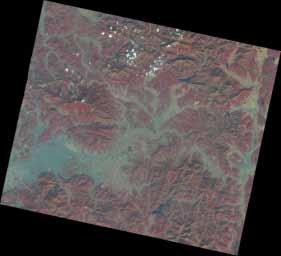
5 KARI & International Charter Haiti Earthquake (JAN 2010) : Provided Analyzed Data with K-2 Haiti earthquake (JAN 15, 2010) 5

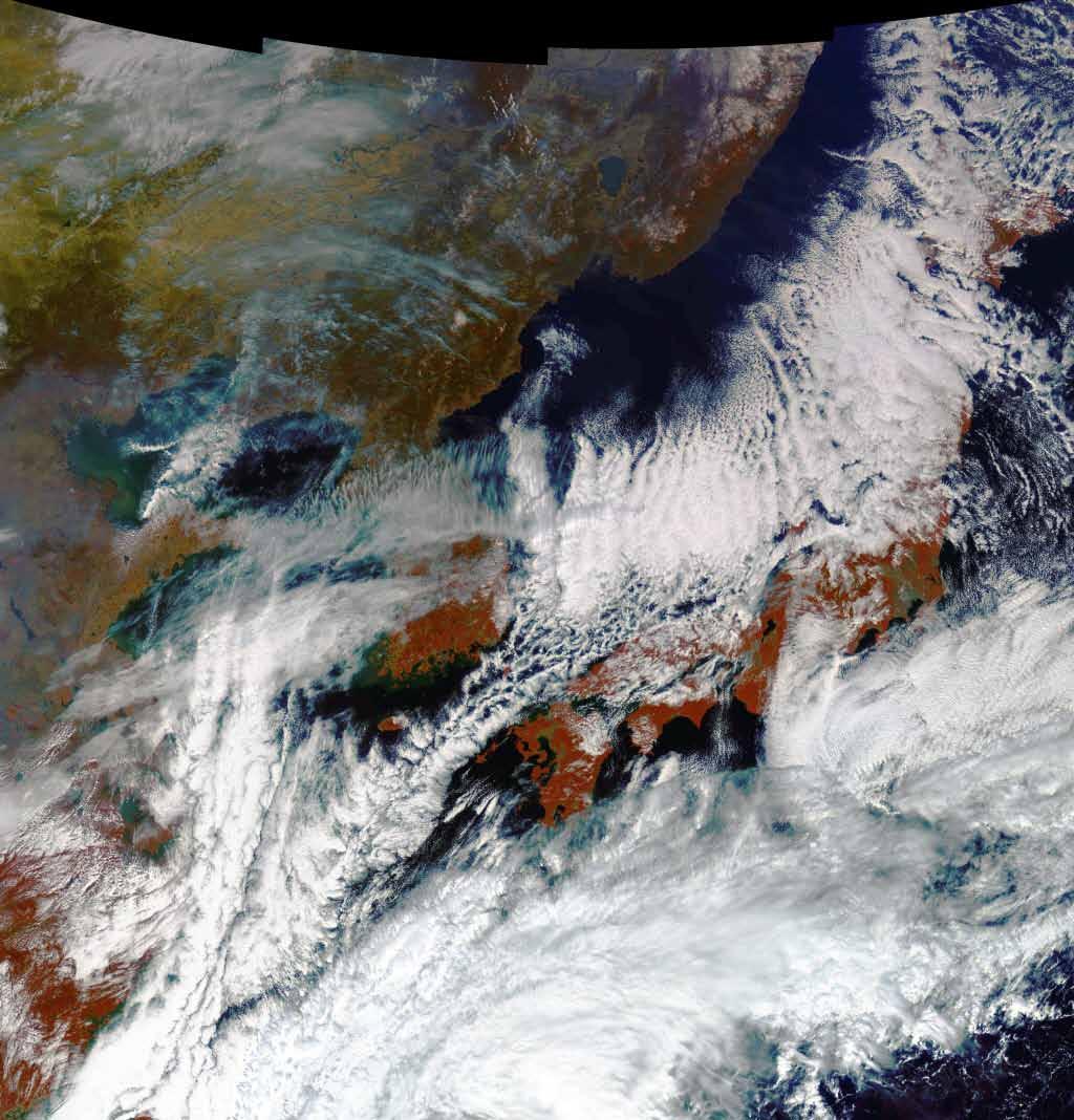
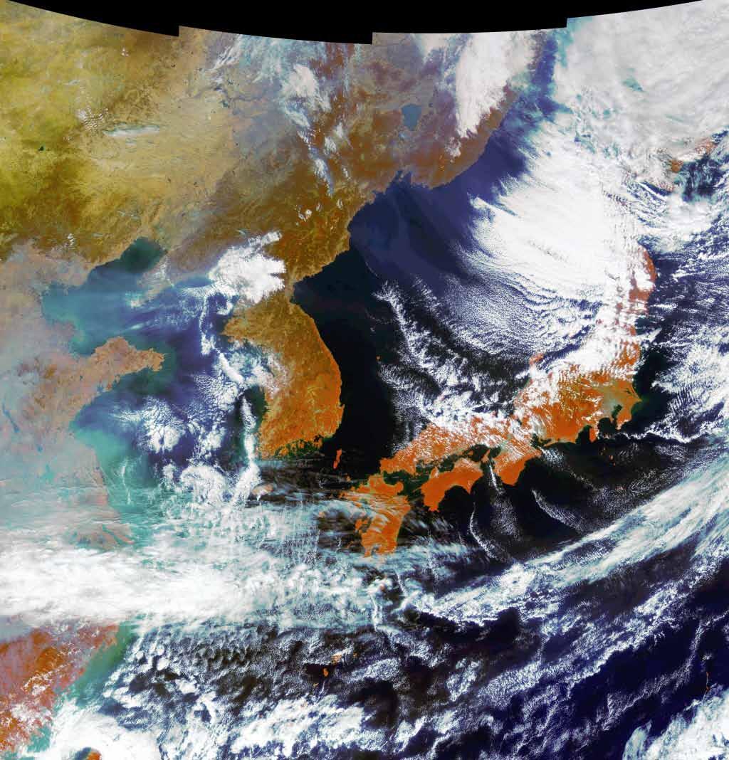
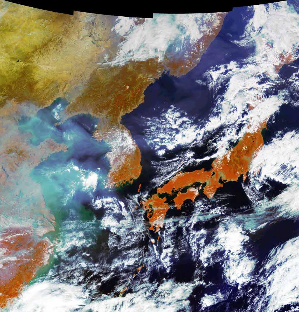
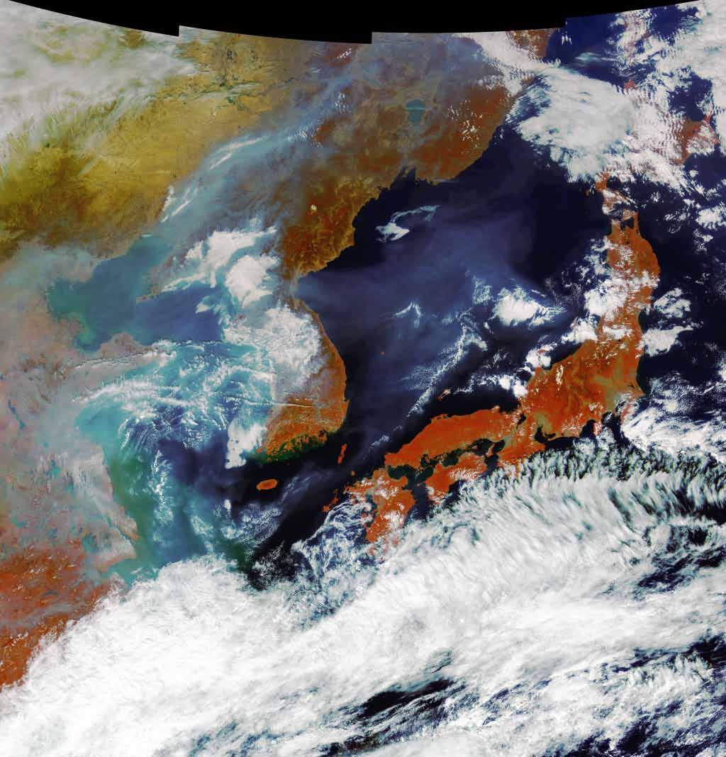
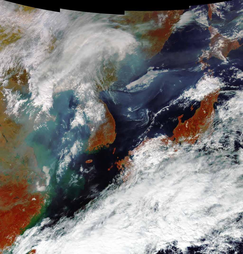
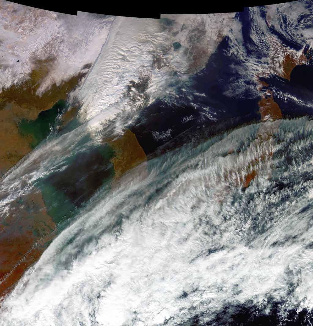
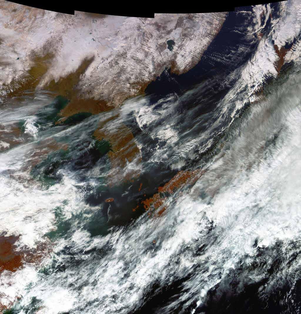
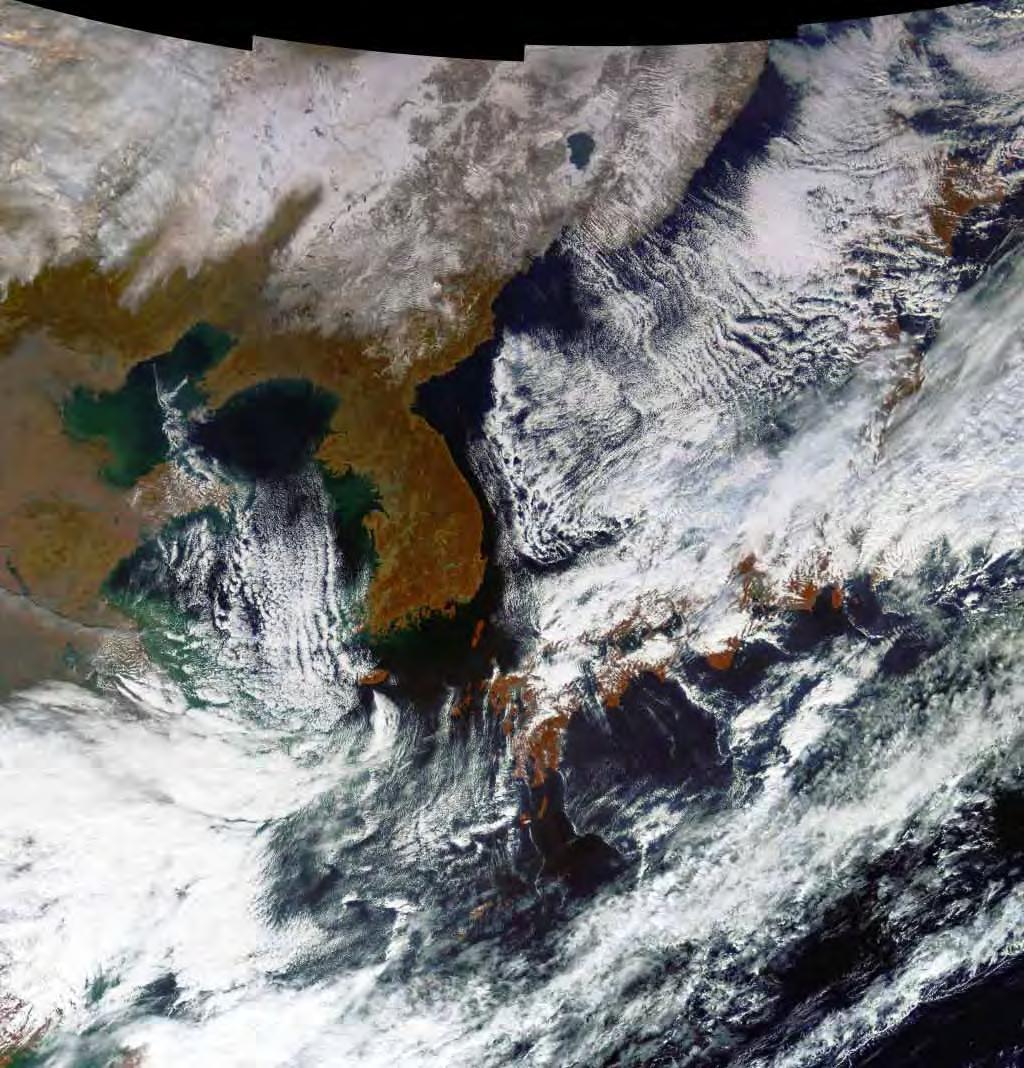
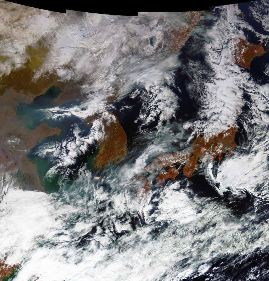
 Tsunami")


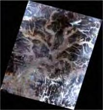
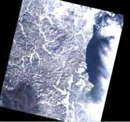
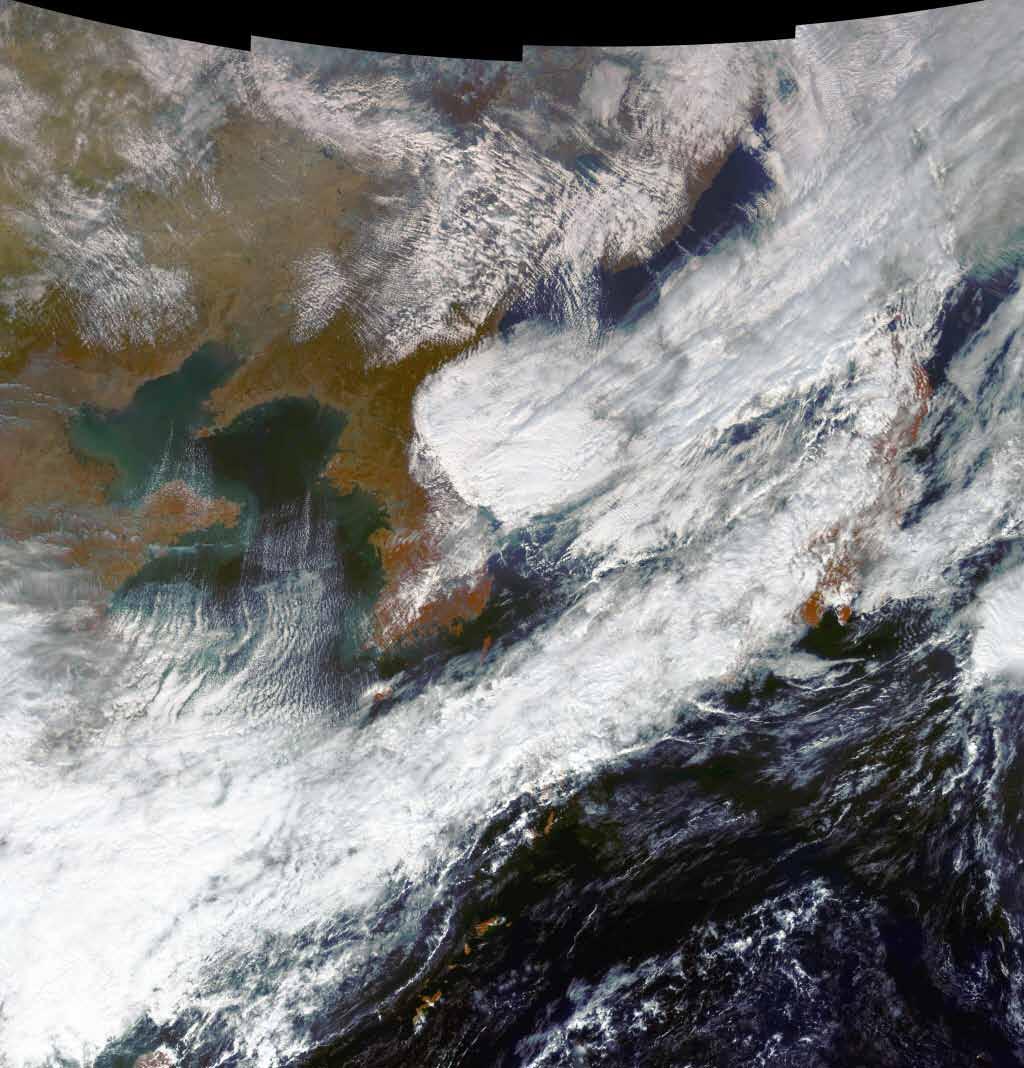
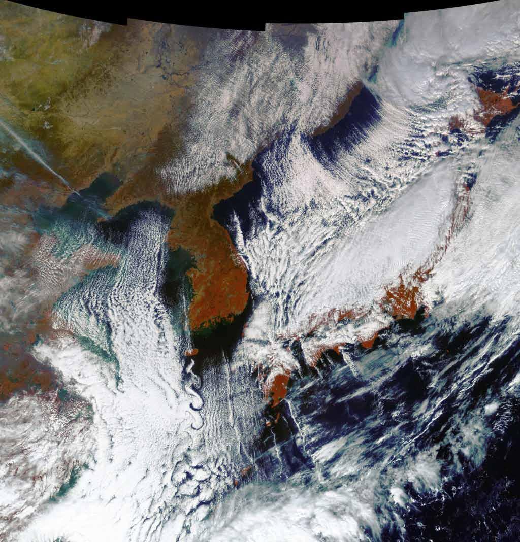
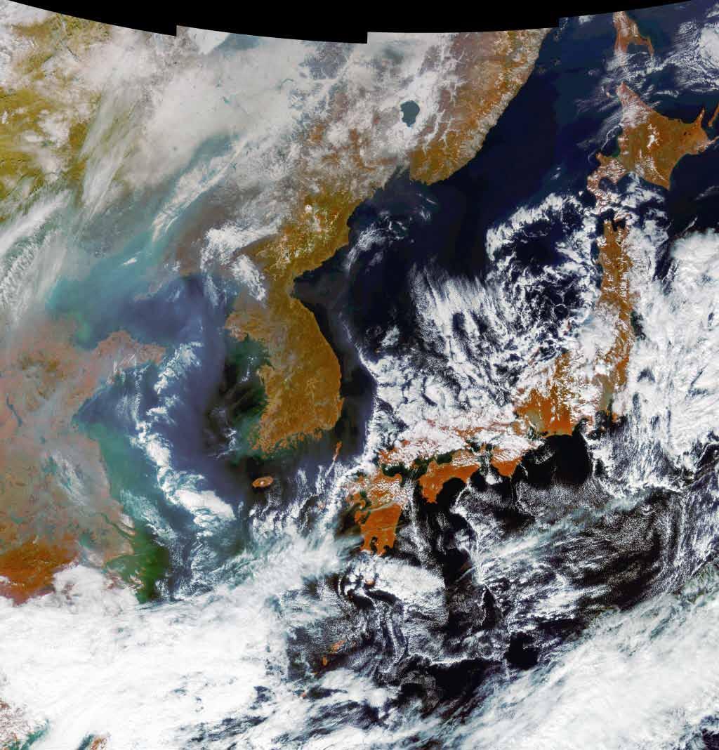
6 KARI & International Charter Sendai (Japan) Tsunami (MAR 2011) : Provided 5 Scenes of K-2 Before After JUN 17, 2008 MAR 14, 2011 NOV 02, 2010 MAR 14,
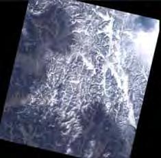
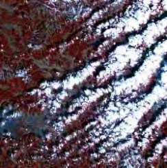
7 KARI & International Charter Korea Heavy Snow (FEB 2011) : Supported 18 Scenes by IC 7

8


9 Satellite Development Program 2025 Lunar Lander 2020 Lunar Orbiter 1999 KOMPSAT STSAT KOMPSAT KSLV STSAT COMS-1 TBD KSLV-I I 2017 KOMPSAT KITSAT -3 TBD Geo-Stat. MultiSat 2015 KOMPSAT STSAT KOMPSAT-3 KOMPSAT- 3A KITSAT : Korea Institute of Technology SATellite KOMPSAT : KOrea Multi-Purpose SATellite STSAT : Science & Technology SATellite 2011 KOMPSAT-5 COMS : Communication, Ocean and Meteorological Satellite 9
 Swath Width :")
10 KOMPSAT-2 Mission Profile KOMPSAT series Launch Date : 28 July 2006 Operational Life : 3 Years Altitude : 685km Orbit : Sun-synchronous Repeating Ground Track : 28days Sensors Panchromatic : 1m Multi-spectral : 4m (R,G,B,NIR) Swath Width : 15km 10
 MODE GSD Swath Width High Resolution 1m 5km Standard 3m 30km Wide Swath 20m")
11 KOMPSAT-5 Mission Profile Launch Date : 2011 Operational Life : 5 Years Altitude : 550km Orbit : Dawn-Dusk Orbit Sensors KOMPSAT series SAR (Synthetic Aperture Radar) MODE GSD Swath Width High Resolution 1m 5km Standard 3m 30km Wide Swath 20m 100km 11
12 KOMPSAT-3 Mission Profile Launch Date : 2012 Operational Life : 4 Years Altitude : 685km Orbit : Sun-synchronous Sensors KOMPSAT series Panchromatic : 0.7m Multi-spectral : 2.8m (R,G,B,NIR) Swath Width : 15km Launch Vehicle H2A (Mitsubishi, Japan) 12

13 KOMPSAT-3A Mission Profile Launch Date : 2013 Operational Life : 4 Years Altitude : 530km Orbit : Sun-synchronous Sensors KOMPSAT series Panchromatic : 0.7m GSD Multi-spectral : 2.8m (R,G,B,NIR) Infra-Red Camera 15km Swath Width 13

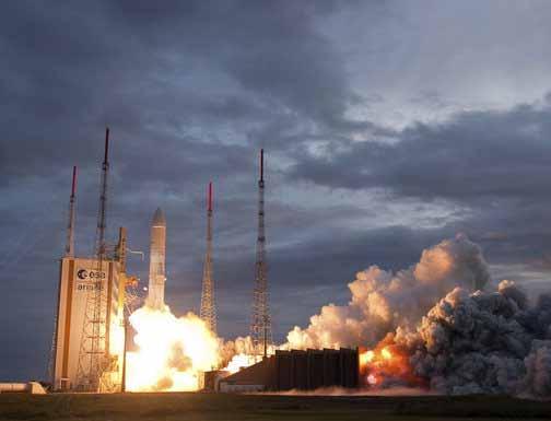
14 COMS-1 Mission Profile COMS Launch Date : 27 June 2010 Operational Life : 7 years Altitude : 36,000km Orbit : Geo-stationary Sensors Communication Ocean Meteorological 14


15 COMS-1 Weather Monitoring Mission Continuous monitoring of imagery and extracting of meteorological products with high-resolution and multi-spectral imager Early detection of special weather such as typhoon, yellow dust, etc. Monitoring of long-term change of sea surface temperature and cloud 15

 Monitoring of long-term/short-term change of marine")
16 COMS-1 Ocean Monitoring Mission Monitoring of marine environments around the Korean peninsula Production of fishery information (Chlorophyll, etc.) Monitoring of long-term/short-term change of marine ecosystem GOCI 8 bands spectral imager 16
17 COMS 17

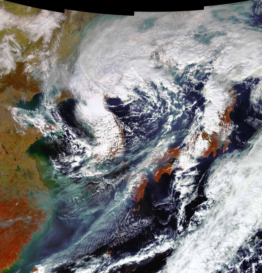
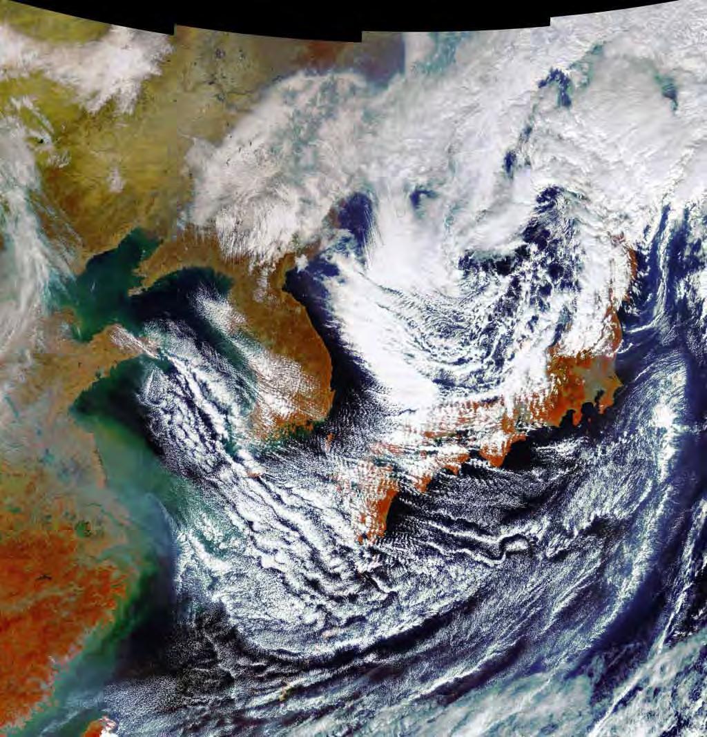
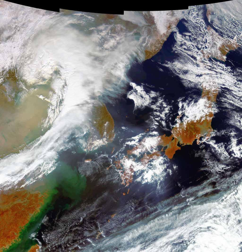
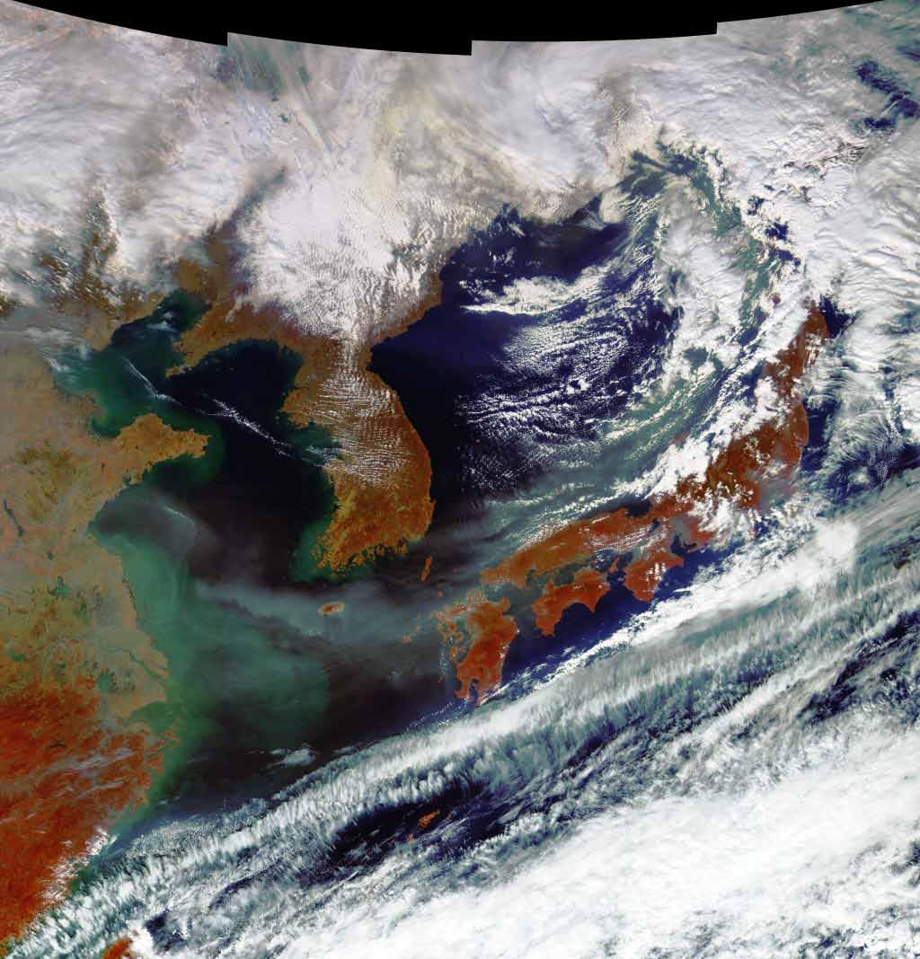
18 STSAT-3 Mission Profile STSAT Launch Date : 2012 (with KSLV-1) Operational Life : 2 Years Altitude : km Orbit : Elliptical orbit Sensors MIRIS Land Surface Temperature 42m GSD (13.4 km Swath-width) COMIS Hyper-spectral Imager Strip Mode (30m GSD, 15km Swath-width) Stereo Mode (60m GSD, 30km Swath-width) 18


19 KSLV Korea Space Launch Vehicle KSLV-1 Capacities : 100kg class satellite, Low-Earth Orbit Attempt Launched Date : July 2009, June


20 NARO Space Center Space Center Tracking Station II Mission Director Center Meteorological Station Tracking Station I Launch Complex (Launch Pad & Erector) 20

21


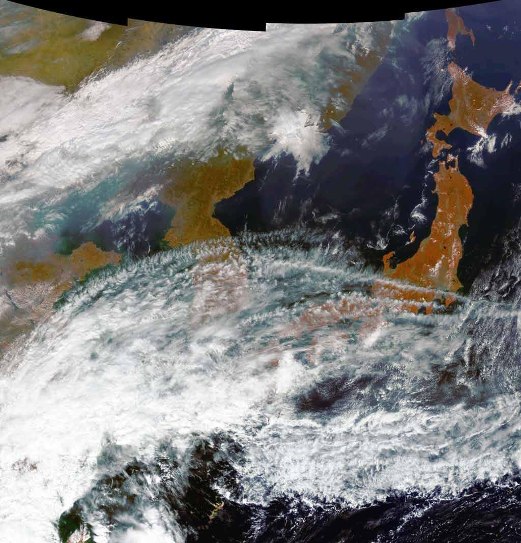
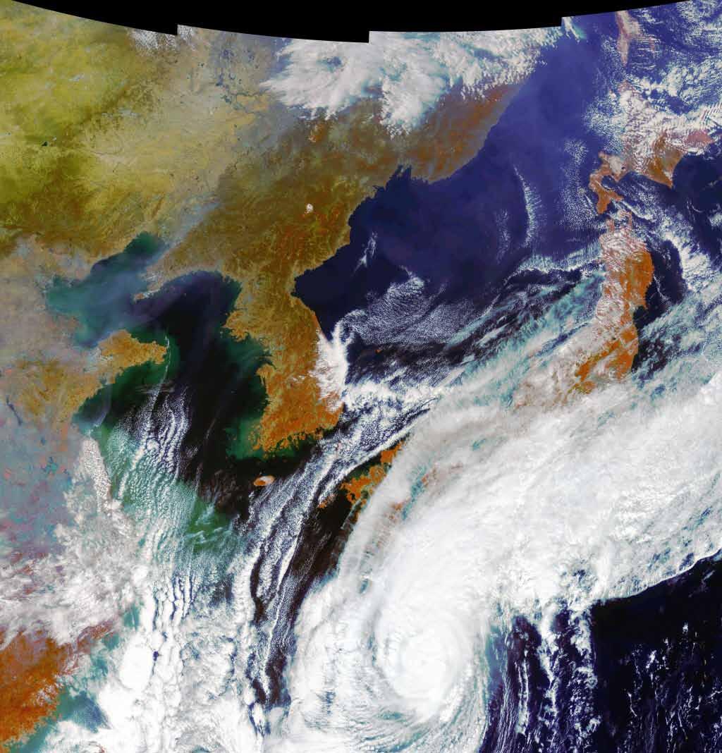
22 Tsunami (Sendai, Japan) JUN 17, 2008 MAR 14,


23 Tsunami (Sendai, Japan) JUN 17, 2008 MAR 14,


24 Tsunami (Sendai, Japan) JUN 17, 2008 MAR 14,


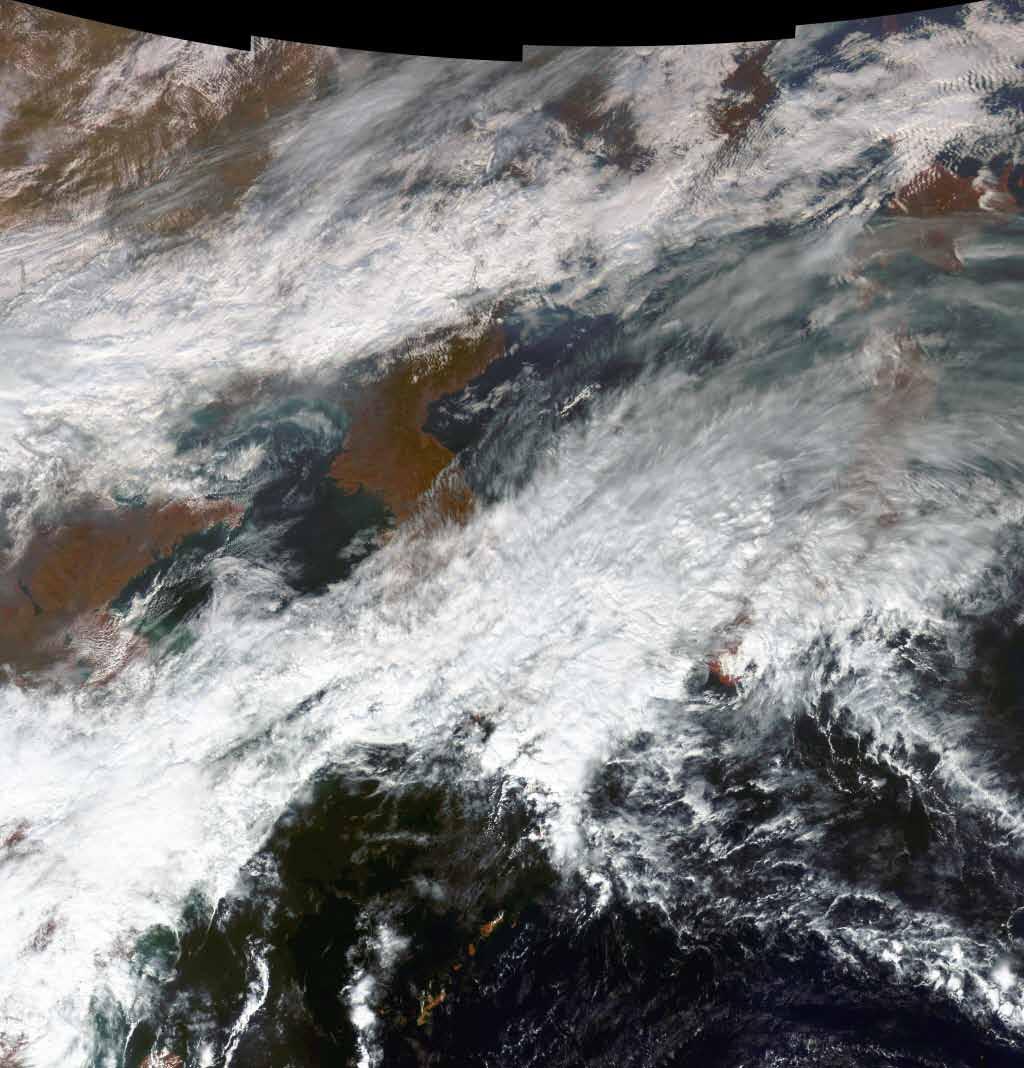
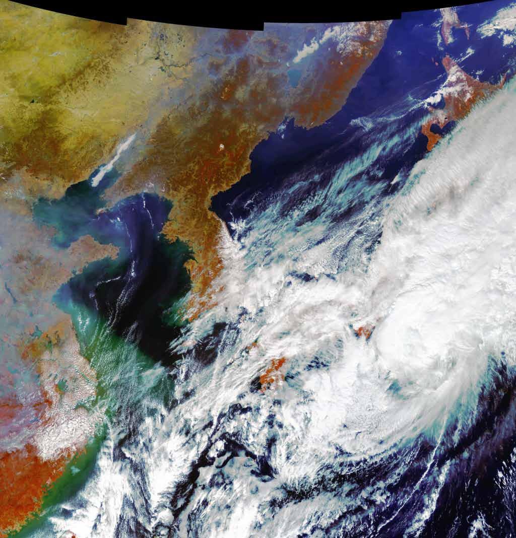
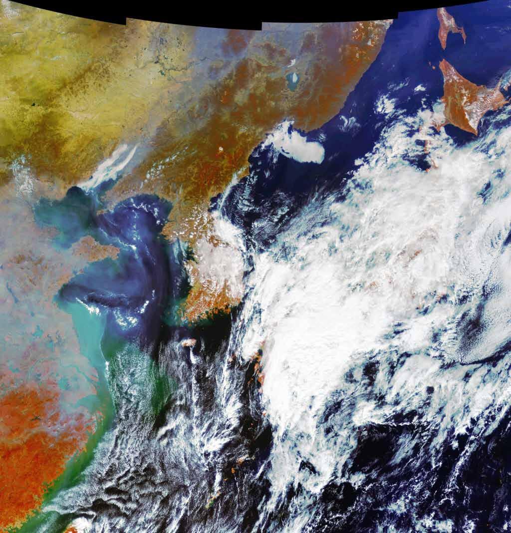
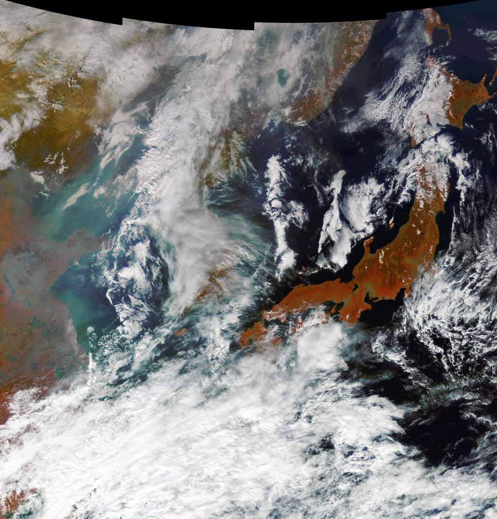
25 Tsunami (Sendai, Japan) NOV 10, 2010 MAR 14,


26 Tsunami (Sendai, Japan) NOV 10, 2010 MAR 14,


27 Tsunami (Sendai, Japan) NOV 10, 2010 MAR 14,


28

29 COMS Visible Image 29


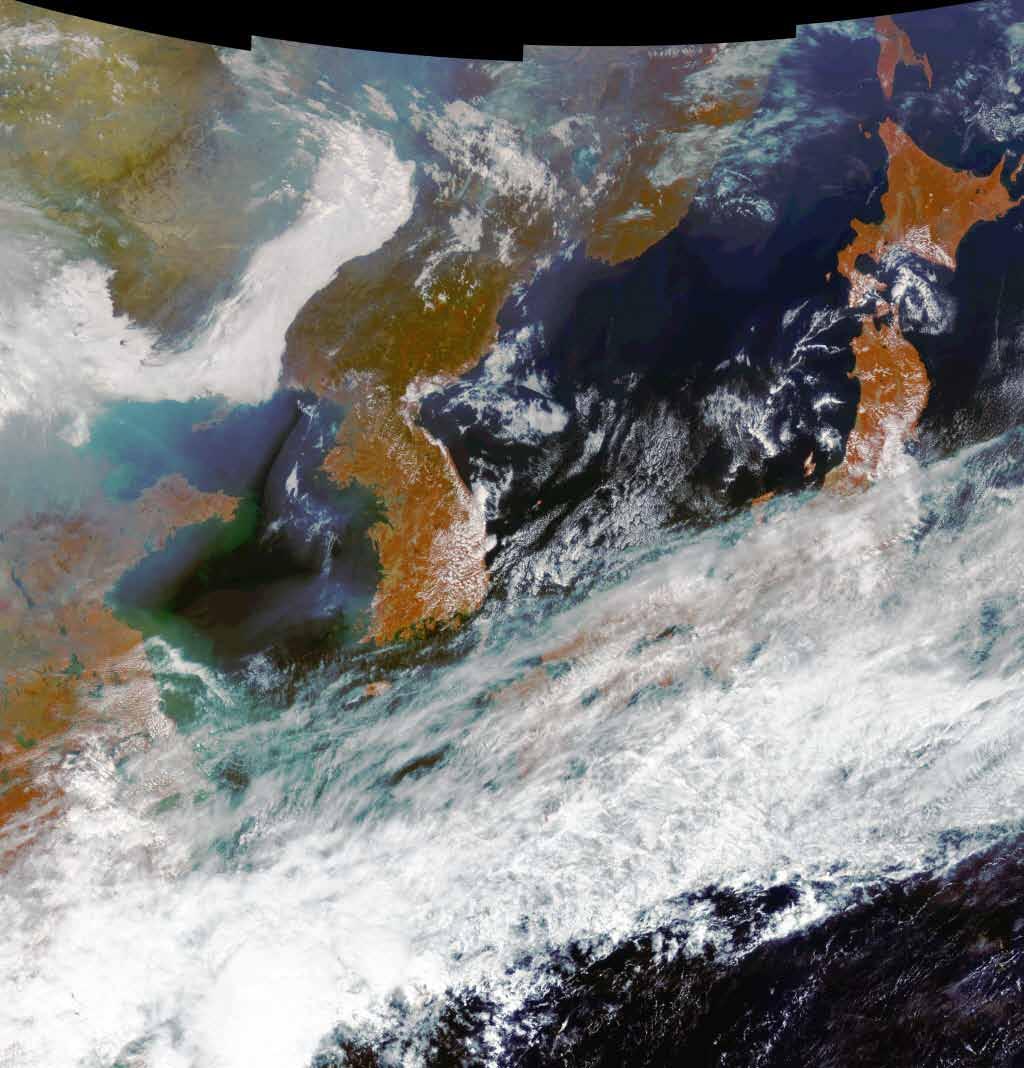


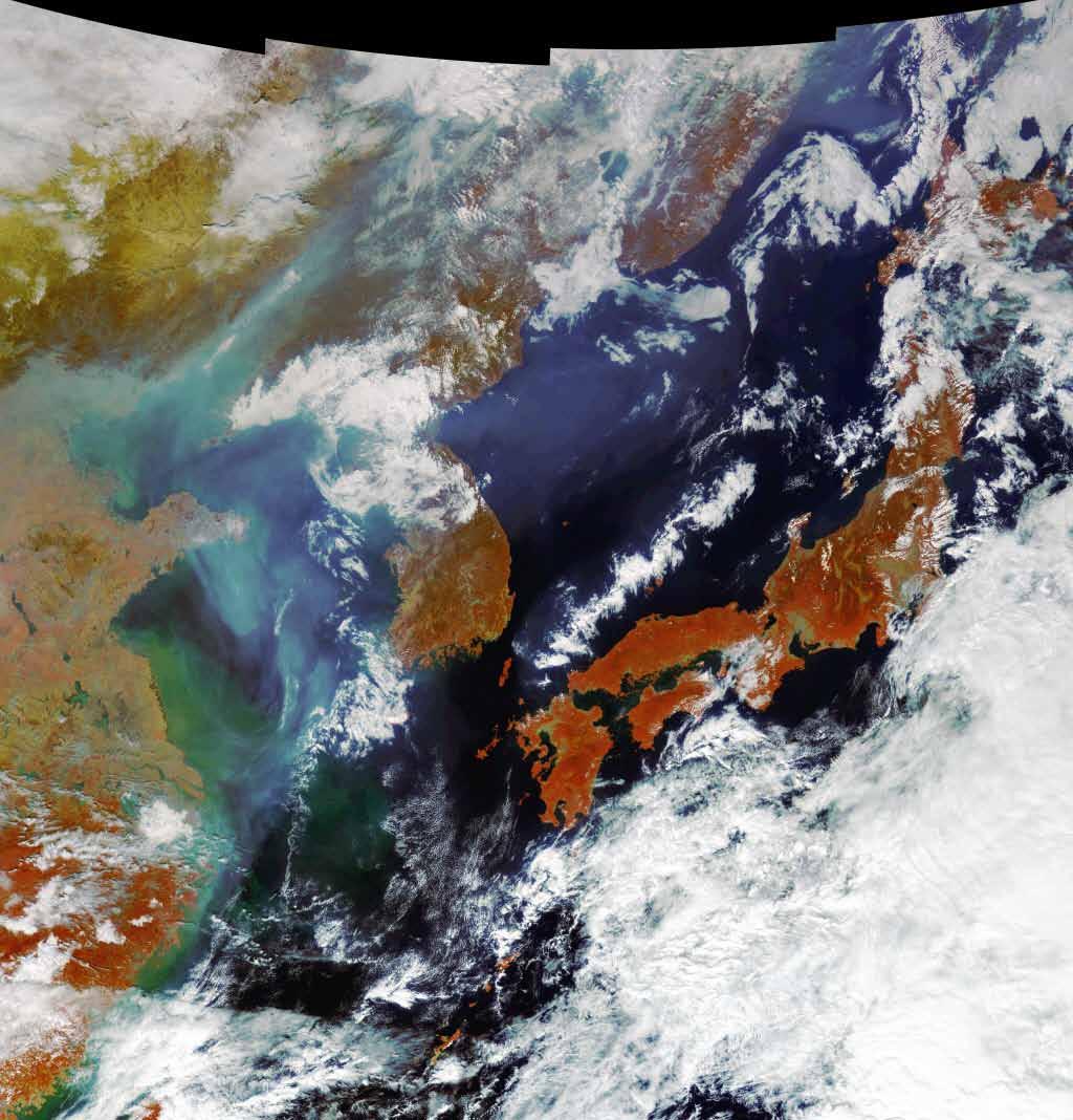
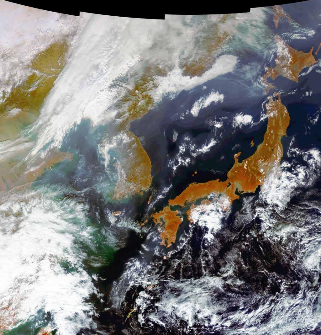
30 COMS Visible Image ( ~ ) 30

 (MODIS")
31 COMS vs. MODIS Yangtze River, China (COMS, 2010/07/31) (MODIS Aqua, 2010/07/31) 31
 (MODIS Aqua, 20100731)")
32 COMS vs. MERIS Yangtze River, China (GOCI, ) (MODIS Aqua, ) COMS (2010/09/24, 01:16:43) MERIS(2010/09/24, 01: 43:51) 32

33 Realization of Korea s New Values and Our Aspiration Towards The Sky and Space! Korea Aerospace Research Institute
Geospatial Vision and Policies Korean Industry View 26 November, 2014 SI Imaging Services
 Geospatial Vision and Policies Korean Industry View 26 November, 2014 SI Imaging Services Distribution Limitation, SI Imaging Services Proprietary Data : The data contained in this document, without the
Drafting Committee for the Asia Pacific Plan of Action for Space Applications for Sustainable Development ( ) Republic of Korea
 Republic of Korea") Drafting Committee for the Asia Pacific Plan of Action for Space Applications for Sustainable Development (2018 2030) Republic of Korea Bangkok, Thailand 31 May 1 June 2018 김 1 KARI Introduction Government
Drafting Committee for the Asia Pacific Plan of Action for Space Applications for Sustainable Development (2018 2030) Republic of Korea Bangkok, Thailand 31 May 1 June 2018 김 1 KARI Introduction Government
KOMPSAT Constellation. November 2012 Satrec Initiative
 KOMPSAT Constellation November 2012 Satrec Initiative KOMPSAT Constellation KOMPSAT National program Developed and operated by KARI (Korea Aerospace Research Institute) Dual use : Government & commercial
9/12/2011. Training Course Remote Sensing Basic Theory & Image Processing Methods September 2011
 Training Course Remote Sensing Basic Theory & Image Processing Methods 19 23 September 2011 Popular Remote Sensing Sensors & their Selection Michiel Damen (September 2011) damen@itc.nl 1 Overview Low resolution
Introduction to KOMPSAT
 Introduction to KOMPSAT September, 2016 1 CONTENTS 01 Introduction of SIIS 02 KOMPSAT Constellation 03 New : KOMPSAT-3 50 cm 04 New : KOMPSAT-3A 2 KOMPSAT Constellation KOMPSAT series National space program
GOCI Status and Cooperation with CoastColour Project
 GOCI Status and Cooperation with CoastColour Project Joo-Hyung RYU Contribution from : KOSC colleaques Nov. 17, 2010 World 1 st GOCI/COMS Launch Campaign Launch Date : June 27 2010 Launch Vehicle : Ariane-V
OVERVIEW OF KOMPSAT-3A CALIBRATION AND VALIDATION
 OVERVIEW OF KOMPSAT-3A CALIBRATION AND VALIDATION DooChun Seo 1, GiByeong Hong 1, ChungGil Jin 1, DaeSoon Park 1, SukWon Ji 1 and DongHan Lee 1 1 KARI(Korea Aerospace Space Institute), 45, Eoeun-dong,
XSAT Ground Segment at CRISP
 XSAT Ground Segment at CRISP LIEW Soo Chin Head of Research, CRISP http://www.crisp.nus.edu.sg 5 th JPTM for Sentinel Asia Step-2, 14-16 Nov 2012, Daejeon, Korea Centre for Remote Imaging, Sensing and
Korea s First Satellite for Satellite Laser Ranging
 1 Korea s First Satellite for Satellite Laser Ranging 1 Jun Ho Lee 1, S. B. Kim 1, K.H. Kim 1, S. H. Lee 1, Y. J. Im 1, Y. Fumin 2, C. Wanzhen 2 1 Korea Advanced Institute of Science and Technology, South
Science and Technology SATellite Program of KOREA
 Science and Technology SATellite Program of KOREA November 2, 2004-1- Contents Introduction KITSAT (Korea Institute of Technology SATellite) STSAT (Science and Technology SATellite) KOMPSAT (KOrea( Multi-Purpose
Big picture with KOMPSAT KOMPSAT-3A / KOMPSAT-3 / KOMPSAT-5 / KOMPSAT-2
 Big picture with KOMPSAT KOMPSAT-3A / KOMPSAT-3 / KOMPSAT-5 / KOMPSAT-2 Big picture with KOMPSAT Introduction SI Imaging Services (SIIS) is the exclusive worldwide marketing and sales representative of
STRATEGIC CHOICES FOR SMALL AND MIDDLE POWERS
 Chapter Five STRATEGIC CHOICES FOR SMALL AND MIDDLE POWERS SPACE DEVELOPMENT IN KOREA Hong-Yul Paik, Director, Satellite Operation Center, Korea Aerospace Research Institute, South Korea Korea is a young
NON-PHOTOGRAPHIC SYSTEMS: Multispectral Scanners Medium and coarse resolution sensor comparisons: Landsat, SPOT, AVHRR and MODIS
 NON-PHOTOGRAPHIC SYSTEMS: Multispectral Scanners Medium and coarse resolution sensor comparisons: Landsat, SPOT, AVHRR and MODIS CLASSIFICATION OF NONPHOTOGRAPHIC REMOTE SENSORS PASSIVE ACTIVE DIGITAL
Advanced Meteorological Imager (AMI) Development for GEO-KOMPSAT-2A
 Development for GEO-KOMPSAT-2A") 1 st KMA International Meteorological Satellite Conference Advanced Meteorological Imager (AMI) Development for GEO-KOMPSAT-2A 16 November 2015 Koon-Ho YANG Korea Aerospace Research Institute 1 Agenda
1 st KMA International Meteorological Satellite Conference Advanced Meteorological Imager (AMI) Development for GEO-KOMPSAT-2A 16 November 2015 Koon-Ho YANG Korea Aerospace Research Institute 1 Agenda
Advanced Optical Satellite (ALOS-3) Overviews
 Overviews") K&C Science Team meeting #24 Tokyo, Japan, January 29-31, 2018 Advanced Optical Satellite (ALOS-3) Overviews January 30, 2018 Takeo Tadono 1, Hidenori Watarai 1, Ayano Oka 1, Yousei Mizukami 1, Junichi
K&C Science Team meeting #24 Tokyo, Japan, January 29-31, 2018 Advanced Optical Satellite (ALOS-3) Overviews January 30, 2018 Takeo Tadono 1, Hidenori Watarai 1, Ayano Oka 1, Yousei Mizukami 1, Junichi
The mission concept includes eight visible-to-near-infrared bands,, and a centered at Korea.
 eostationary cean olor mager : ommunication cean and eteorological atellite It shall be operated in a mode onboard its COMS. The mission concept includes eight visible-to-near-infrared bands,, and a centered
An integrated telemetry system for multi-satellite operations
 SpaceOps Conferences 6-20 May 206, Daejeon, Korea SpaceOps 206 Conference 0.254/6.206-237 An integrated telemetry system for multi-satellite operations Hyun Chul Baek and Sang-il Ahn. 2 Korea Aerospace
Lecture 6: Multispectral Earth Resource Satellites. The University at Albany Fall 2018 Geography and Planning
 Lecture 6: Multispectral Earth Resource Satellites The University at Albany Fall 2018 Geography and Planning Outline SPOT program and other moderate resolution systems High resolution satellite systems
Light penetration within a clear water body. E z = E 0 e -kz
 THE BLUE PLANET 1 2 Light penetration within a clear water body E z = E 0 e -kz 3 4 5 6 Pure Seawater Phytoplankton b w 10-2 m -1 b w 10-2 m -1 b w, Morel (1974) a w, Pope and Fry (1997) b chl,loisel and
FORMOSAT-2 FOR INTERNATIONAL SOCIETAL BENEFITS
 FORMOSAT-2 FOR INTERNATIONAL SOCIETAL BENEFITS Ming-Chih Cheng 1, Celine Zhang 2 1 Researcher, 2 Research Assistant National Space Organization ABSTRACT The Group on Earth Observations (GEO), established
Current and Future Meteorological Satellite Program of China
 Current and Future Meteorological Satellite Program of China ZHANG Wenjian, DONG Chaohua XU Jianmin, YANG Jun China Meteorological Administration May 30, 2005 Beijing, CHINA Outline of the Presentation
National SPace Organization
 National SPace Organization A center of innovation and excellence for space technology Bo Chen National Space Organization Presented at JPTM 2014, Sentinel Asia Yangon, Myanmar, 11/19-21 NARLabs-NSPO About
3/31/03. ESM 266: Introduction 1. Observations from space. Remote Sensing: The Major Source for Large-Scale Environmental Information
 Remote Sensing: The Major Source for Large-Scale Environmental Information Jeff Dozier Observations from space Sun-synchronous polar orbits Global coverage, fixed crossing, repeat sampling Typical altitude
ROLE OF SATELLITE DATA APPLICATION IN CADASTRAL MAP AND DIGITIZATION OF LAND RECORDS DR.T. RAVISANKAR GROUP HEAD (LRUMG) RSAA/NRSC/ISRO /DOS HYDERABAD
 RSAA/NRSC/ISRO /DOS HYDERABAD") ROLE OF SATELLITE DATA APPLICATION IN CADASTRAL MAP AND DIGITIZATION OF LAND RECORDS DR.T. RAVISANKAR GROUP HEAD (LRUMG) RSAA/NRSC/ISRO /DOS HYDERABAD WORKSHOP on Best Practices under National Land Records
ROLE OF SATELLITE DATA APPLICATION IN CADASTRAL MAP AND DIGITIZATION OF LAND RECORDS DR.T. RAVISANKAR GROUP HEAD (LRUMG) RSAA/NRSC/ISRO /DOS HYDERABAD WORKSHOP on Best Practices under National Land Records
Copernicus Introduction Lisbon, Portugal 13 th & 14 th February 2014
 Copernicus Introduction Lisbon, Portugal 13 th & 14 th February 2014 Contents Introduction GMES Copernicus Six thematic areas Infrastructure Space data An introduction to Remote Sensing In-situ data Applications
Trend of Small EO Satellites and Their Applications
 UN Symposium to Strengthen the Partnership with Industry Nurturing the Development of Space Technology Trend of Small EO Satellites and Their Applications For further information, Phone: +82 42 365 7506
The Sentinel-1 Constellation
 The Sentinel-1 Constellation Evert Attema, Sentinel-1 Mission & System Manager AGRISAR and EAGLE Campaigns Final Workshop 15-16 October 2007 ESA/ESTECNoordwijk, The Netherlands Sentinel-1 Programme Sentinel-1
REMOTE SENSING FOR FLOOD HAZARD STUDIES.
 REMOTE SENSING FOR FLOOD HAZARD STUDIES. OPTICAL SENSORS. 1 DRS. NANETTE C. KINGMA 1 Optical Remote Sensing for flood hazard studies. 2 2 Floods & use of remote sensing. Floods often leaves its imprint
PEGASUS : a future tool for providing near real-time high resolution data for disaster management. Lewyckyj Nicolas
 PEGASUS : a future tool for providing near real-time high resolution data for disaster management Lewyckyj Nicolas nicolas.lewyckyj@vito.be http://www.pegasus4europe.com Overview Vito in a nutshell GI
GMES DA COPERNICUS
 2014 Airbus Defence and Space All rights reserved. The reproduction, distribution and utilization of this document as well as the communication of its contents to others without express authorization is
The studies began when the Tiros satellites (1960) provided man s first synoptic view of the Earth s weather systems.
 provided man s first synoptic view of the Earth s weather systems.") Remote sensing of the Earth from orbital altitudes was recognized in the mid-1960 s as a potential technique for obtaining information important for the effective use and conservation of natural resources.
Remote sensing of the Earth from orbital altitudes was recognized in the mid-1960 s as a potential technique for obtaining information important for the effective use and conservation of natural resources.
Introduction to Remote Sensing Fundamentals of Satellite Remote Sensing. Mads Olander Rasmussen
 Introduction to Remote Sensing Fundamentals of Satellite Remote Sensing Mads Olander Rasmussen (mora@dhi-gras.com) 01. Introduction to Remote Sensing DHI What is remote sensing? the art, science, and technology
KONGSBERG SATELLITE SERVICES 2017 Line Steinbakk, Director Programs. Himmel og hav - Ålesund 3. Oktober 2017
 KONGSBERG SATELLITE SERVICES 2017 Line Steinbakk, Director Programs Himmel og hav - Ålesund 3. Oktober 2017 KSAT HQ IN TROMSØ 69N Established in 1967 Kongsberg Satellite Services since 2002 World leading
1. INTRODUCTION. GOCI : Geostationary Ocean Color Imager
 1. INTRODUCTION The Korea Ocean Research and Development Institute (KORDI) releases an announcement of opportunity (AO) to carry out scientific research for the utilization of GOCI data. GOCI is the world
Lecture 1 Introduction to Remote Sensing
 Lecture 1 Introduction to Remote Sensing Dr Ian Leiper School of Environmental and Life Sciences Bldg Purple 12.2.27 1 2 Lecture Outline Introductions Unit admin Learning outcomes Unit outline Practicals
Aral Sea profile Selection of area 24 February April May 1998
 250 km Aral Sea profile 1960 1960 1985 1986 1987 1988 1989 1990 1991 1992 1993 1994 1995 1996 1997 1998 2010? Selection of area Area of interest Kzyl-Orda Dried seabed 185 km Syrdarya river Aral Sea Salt
The Global Imager (GLI)
") The Global Imager (GLI) Launch : Dec.14, 2002 Initial check out : to Apr.14, 2003 (~L+4) First image: Jan.25, 2003 Second image: Feb.6 and 7, 2003 Calibration and validation : to Dec.14, 2003(~L+4) for
The Global Imager (GLI) Launch : Dec.14, 2002 Initial check out : to Apr.14, 2003 (~L+4) First image: Jan.25, 2003 Second image: Feb.6 and 7, 2003 Calibration and validation : to Dec.14, 2003(~L+4) for
An Introduction to Geomatics. Prepared by: Dr. Maher A. El-Hallaq خاص بطلبة مساق مقدمة في علم. Associate Professor of Surveying IUG
 An Introduction to Geomatics خاص بطلبة مساق مقدمة في علم الجيوماتكس Prepared by: Dr. Maher A. El-Hallaq Associate Professor of Surveying IUG 1 Airborne Imagery Dr. Maher A. El-Hallaq Associate Professor
Time Trend Evaluations of Absolute Accuracies for PRISM and AVNIR-2
 The 3 rd ALOS Joint PI Symposium, Kona, Hawaii, US Nov. 9-13, 2009 Time Trend Evaluations of Absolute Accuracies for PRISM and AVNIR-2 Takeo Tadono*, Masanobu Shimada*, Hiroshi Murakami*, Junichi Takaku**,
On the use of water color missions for lakes in 2021
 Lakes and Climate: The Role of Remote Sensing June 01-02, 2017 On the use of water color missions for lakes in 2021 Cédric G. Fichot Department of Earth and Environment 1 Overview 1. Past and still-ongoing
Sensor resolutions from space: the tension between temporal, spectral, spatial and swath. David Bruce UniSA and ISU
 Sensor resolutions from space: the tension between temporal, spectral, spatial and swath David Bruce UniSA and ISU 1 Presentation aims 1. Briefly summarize the different types of satellite image resolutions
Remote Sensing Platforms
 Types of Platforms Lighter-than-air Remote Sensing Platforms Free floating balloons Restricted by atmospheric conditions Used to acquire meteorological/atmospheric data Blimps/dirigibles Major role - news
Light penetration within a clear water body. E z = E 0 e -kz
 THE BLUE PLANET 1 2 Light penetration within a clear water body E z = E 0 e -kz 3 4 5 Pure Seawater Phytoplankton b w 10-2 m -1 b w 10-2 m -1 b w, Morel (1974) a w, Pope and Fry (1997) b chl,loisel and
UPDATE ON COMS PROGRAM
 Prepared by KMA Agenda Item: C.2 Discussed in Plenary UPDATE ON COMS PROGRAM This document is to update the COMS program as a part of CGMS-34-WMO-WP-25. Currently, the integration of COMS system has been
ERS/ENVISAT ASAR Data Products and Services
 ERS/ENVISAT ASAR Data Products and Services Andrea Celentano Business Manager celentan@eurimage.com What is Eurimage? Founded in 1989 Current shareholders: Since 1989 Commercial Partner of the European
Satellite Imagery and Remote Sensing. DeeDee Whitaker SW Guilford High EES & Chemistry
 Satellite Imagery and Remote Sensing DeeDee Whitaker SW Guilford High EES & Chemistry whitakd@gcsnc.com Outline What is remote sensing? How does remote sensing work? What role does the electromagnetic
44 th CGMS, Biot France. New Era, System Capacity, Global Contribution, the Vision and Future of China Space
 44 th CGMS, Biot France New Era, System Capacity, Global Contribution, the Vision and Future of China Space China National Space Administration Wang Cheng, Jun 9 2016 Three Milestones of China s Space
Remote Sensing for Resource Management
 Remote Sensing for Resource Management Ebenezer Nyadjro US Naval Research Lab/UNO RMU Summer Program (July 31-AUG 4, 2017) Motivation Polluted Pra River Motivation. 3 Motivation Polluted Pra River Motivation.
Maximize Utilization of the performance of EOSs and strengthen. The First Steering Committee Secretariat JAXA
 Maximize Utilization of the performance of EOSs and strengthen cooperation among DPN/DAN The First Steering Committee Secretariat JAXA ALOS 2 observation is strong tool for disaster monitoring Wide area/range
FORMOSAT-2, KOMPSAT-2, ASTROTERRA
 FORMOSAT-2, KOMPSAT-2, ASTROTERRA Igor Lampin, Didier Giacobbo - SPOT IMAGE S.A. GSCB Workshop, ESA/ESRIN Frascati FORMOSAT-2 Mission status F-2 is owned by Taiwan National Space Organisation (NSPO), designed
CHARACTERISTICS OF REMOTELY SENSED IMAGERY. Spatial Resolution
 CHARACTERISTICS OF REMOTELY SENSED IMAGERY Spatial Resolution There are a number of ways in which images can differ. One set of important differences relate to the various resolutions that images express.
Synthetic Aperture Radar for Rapid Flood Extent Mapping
 National Aeronautics and Space Administration ARSET Applied Remote Sensing Training http://arset.gsfc.nasa.gov @NASAARSET Synthetic Aperture Radar for Rapid Flood Extent Mapping Sang-Ho Yun ARIA Team Jet
Global hot spot monitoring with Landsat 8 and Sentinel-2. Soushi Kato Atsushi Oda Ryosuke Nakamura (AIST)
") Global hot spot monitoring with Landsat 8 and Sentinel-2 Soushi Kato Atsushi Oda Ryosuke Nakamura (AIST) Motivation for Detecting Hot Spots Hotspot detection using satellite data To monitor wildfire and
Global hot spot monitoring with Landsat 8 and Sentinel-2 Soushi Kato Atsushi Oda Ryosuke Nakamura (AIST) Motivation for Detecting Hot Spots Hotspot detection using satellite data To monitor wildfire and
Operational Space-Based Imaging Systems
 Operational Space-Based Imaging Systems R E M O T E S E N S I N G & G E O S PAT I A L A N A LY S I S L A B D O I : 2 0 A U G U S T, 2 0 1 6 Earth Observation Systems U.S. or foreign government systems
Japan's Greenhouse Gases Observation from Space
 1 Workshop on EC CEOS Priority on GHG Monitoring Japan's Greenhouse Gases Observation from Space 18 June, 2018@Ispra, Italy Masakatsu NAKAJIMA Japan Aerospace Exploration Agency Development and Operation
9/12/2011. Training Course Remote Sensing Basic Theory & Image Processing Methods September 2011
 Training Course Remote Sensing Basic Theory & Image Processing Methods 19 23 September 2011 Introduction to Remote Sensing Michiel Damen (September 2011) damen@itc.nl 1 Overview Some definitions Remote
FORMOSAT-5. - Launch Campaign-
 1 FORMOSAT-5 - Launch Campaign- FORMOSAT-5 Launch Campaign 2 FORMOSAT-5 Launch Campaign Launch Date: 2017.08.24 U.S. Pacific Time Activities 11:50-12:23 Launch Window 13:30-16:00 Reception 3 FORMOSAT-5
Akio Oniyama 1 and Tetsuo Fukunaga 2 PASCO CORPORATION Nakano, Nakano-ku, Tokyo, Japan
 SpaceOps Conferences 16-20 May 2016, Daejeon, Korea SpaceOps 2016 Conference 10.2514/6.2016-2434 A Case Study of the Data Downlink Methodology for Earth Observation Satellite Akio Oniyama 1 and Tetsuo
SEA GRASS MAPPING FROM SATELLITE DATA
 JSPS National Coordinators Meeting, Coastal Marine Science 19 20 May 2008 Melaka SEA GRASS MAPPING FROM SATELLITE DATA Mohd Ibrahim Seeni Mohd, Nurul Hazrina Idris, Samsudin Ahmad 1. Introduction PRESENTATION
Table Satellites used for observations by members of the Disaster Charter and others (except Daichi)
") 2.1.4 Cooperation with from overseas institutions JAXA asked Sentinel Asia and, on behalf of the Cabinet Office, the Disaster Charter to carry out emergency observations immediately after the earthquake
2.1.4 Cooperation with from overseas institutions JAXA asked Sentinel Asia and, on behalf of the Cabinet Office, the Disaster Charter to carry out emergency observations immediately after the earthquake
Monitoring Natural Disasters with Small Satellites Smart Satellite Based Geospatial System for Environmental Protection
 Monitoring Natural Disasters with Small Satellites Smart Satellite Based Geospatial System for Environmental Protection Krištof Oštir, Space-SI, Slovenia Contents Natural and technological disasters Current
Update on Landsat Program and Landsat Data Continuity Mission
 Update on Landsat Program and Landsat Data Continuity Mission Dr. Jeffrey Masek LDCM Deputy Project Scientist NASA GSFC, Code 923 November 21, 2002 Draft LDCM Implementation Phase RFP Overview Page 1 Celebrate!
Remote Sensing Platforms
 Remote Sensing Platforms Remote Sensing Platforms - Introduction Allow observer and/or sensor to be above the target/phenomena of interest Two primary categories Aircraft Spacecraft Each type offers different
Geomatica OrthoEngine v10.2 Tutorial Orthorectifying ALOS PRISM Data Rigorous and RPC Modeling
 Geomatica OrthoEngine v10.2 Tutorial Orthorectifying ALOS PRISM Data Rigorous and RPC Modeling ALOS stands for Advanced Land Observing Satellite and was developed by the Japan Aerospace Exploration Agency
The Current Status and Brief Results of Engineering Model for PALSAR-2 onboard ALOS-2 and Science Project
 The Current Status and Brief Results of Engineering Model for PALSAR-2 onboard ALOS-2 and Science Project + The 16 th KC meeting Japan Aerospace Exploration Agency Masanobu Shimada, Yukihiro KANKAKU The
RADARSAT-2 and RCM Conjunction Analysis and Mitigation Operations
 RADARSAT-2 and RCM Conjunction Analysis and Mitigation Operations Casey Lambert (MDA), Camille Decoust (MDA), Bryan Cooke (SED) www.mdacorporation.com Presentation Outline Introduction to RADARSAT-2 Collision
OVERVIEW OF THE ALOS SATELLITE SYSTEM
 OVERVIEW OF THE ALOS SATELLITE SYSTEM Presented to The Symposium for ALOS Data Application Users @Kogakuin University, Tokyo, Japan Mar. 27, 2001 Takashi Hamazaki Senior Engineer ALOS Project National
remote sensing? What are the remote sensing principles behind these Definition
 Introduction to remote sensing: Content (1/2) Definition: photogrammetry and remote sensing (PRS) Radiation sources: solar radiation (passive optical RS) earth emission (passive microwave or thermal infrared
DEVELOPMENT OF THE NEW GENERATION OF GEOSTATIONARY OCEAN COLOR IMAGER
 DEVELOPMENT OF THE NEW GENERATION OF GEOSTATIONARY OCEAN COLOR IMAGER Pierre Coste 1, Franck Larnaudie 1, Philippe Luquet 1, Haengpal Heo 2, Junpyung Jung 2, Gmsil Kang 2, Sangyoun Shin 2, Sangsoon Yong
Sources of Geographic Information
 Sources of Geographic Information Data properties: Spatial data, i.e. data that are associated with geographic locations Data format: digital (analog data for traditional paper maps) Data Inputs: sampled
KOMPSAT-2 Orbit Determination using GPS SIgnals
 Presented at GNSS 2004 The 2004 International Symposium on GNSS/GPS Sydney, Australia 6 8 December 2004 KOMPSAT-2 Orbit Determination using GPS SIgnals Dae-Won Chung KOMPSAT Systems Engineering and Integration
Available Ocean Color Satellite Imagery
 Available Ocean Color Satellite Imagery Mati Kahru Scripps Institution of Oceanography UCSD, La Jolla, CA 92093-0218, USA mkahru@ucsd.edu also at WimSoft, http://www.wimsoft.com Email: wim@wimsoft.com
Coral Reef Remote Sensing
 Coral Reef Remote Sensing Spectral, Spatial, Temporal Scaling Phillip Dustan Sensor Spatial Resolutio n Number of Bands Useful Bands coverage cycle Operation Landsat 80m 2 2 18 1972-97 Thematic 30m 7
PLANET: IMAGING THE EARTH EVERY DAY
 PLANET: IMAGING THE EARTH EVERY DAY Benjamin Trigona-Harany Mailiao Refinery, Taiwan May 31, 2016 To image the whole world every day, making change visible, accessible and actionable. HONG KONG January
The studies began when the Tiros satellites (1960) provided man s first synoptic view of the Earth s weather systems.
 provided man s first synoptic view of the Earth s weather systems.") Remote sensing of the Earth from orbital altitudes was recognized in the mid-1960 s as a potential technique for obtaining information important for the effective use and conservation of natural resources.
Remote sensing of the Earth from orbital altitudes was recognized in the mid-1960 s as a potential technique for obtaining information important for the effective use and conservation of natural resources.
KEY TECHNOLOGY DEVELOPMENT FOR THE ADVENACED LAND OBSERVING SATELLITE
 KEY TECHNOLOGY DEVELOPMENT FOR THE ADVENACED LAND OBSERVING SATELLITE Takashi HAMAZAKI, and Yuji OSAWA National Space Development Agency of Japan (NASDA) hamazaki.takashi@nasda.go.jp yuji.osawa@nasda.go.jp
DEMS BASED ON SPACE IMAGES VERSUS SRTM HEIGHT MODELS. Karsten Jacobsen. University of Hannover, Germany
 DEMS BASED ON SPACE IMAGES VERSUS SRTM HEIGHT MODELS Karsten Jacobsen University of Hannover, Germany jacobsen@ipi.uni-hannover.de Key words: DEM, space images, SRTM InSAR, quality assessment ABSTRACT
UAV applications for oil spill detection, suspended matter distribution and ice monitoring first tests and trials in Estonia 2015/2016
 UAV applications for oil spill detection, suspended matter distribution and ice monitoring first tests and trials in Estonia 2015/2016 Sander Rikka Marine Systems Institute at TUT 1.11.2016 1 Outlook Introduction
Intersatellite Calibration of infrared sensors onboard Indian Geostationary Satellites using LEO Hyperspectral Observations
 Updates from GSICS members and Observers Indian Space Research Organisation (ISRO) Intersatellite Calibration of infrared sensors onboard Indian Geostationary Satellites using LEO Hyperspectral Observations
Int n r t o r d o u d c u ti t on o n to t o Remote Sensing
 Introduction to Remote Sensing Definition of Remote Sensing Remote sensing refers to the activities of recording/observing/perceiving(sensing)objects or events at far away (remote) places. In remote sensing,
SNIPE mission for Space Weather Research. CubeSat Developers Workshop 2017 Jaejin Lee (KASI)
") SNIPE mission for Space Weather Research CubeSat Developers Workshop 2017 Jaejin Lee (KASI) New Challenge with Nanosatellites In observing small-scale plasma structures, single satellite inherently suffers
SNIPE mission for Space Weather Research CubeSat Developers Workshop 2017 Jaejin Lee (KASI) New Challenge with Nanosatellites In observing small-scale plasma structures, single satellite inherently suffers
The Moderate Resolution Imaging Spectroradiometer (MODIS): Potential Applications for Climate Change and Modeling Studies
: Potential Applications for Climate Change and Modeling Studies") The Moderate Resolution Imaging Spectroradiometer (MODIS): Potential Applications for Climate Change and Modeling Studies Menas Kafatos, CEOSR, George Mason University Jim McManus, CEOSR, GMU and GES DISC
The Moderate Resolution Imaging Spectroradiometer (MODIS): Potential Applications for Climate Change and Modeling Studies Menas Kafatos, CEOSR, George Mason University Jim McManus, CEOSR, GMU and GES DISC
IKONOS High Resolution Multispectral Scanner Sensor Characteristics
 High Spatial Resolution and Hyperspectral Scanners IKONOS High Resolution Multispectral Scanner Sensor Characteristics Launch Date View Angle Orbit 24 September 1999 Vandenberg Air Force Base, California,
MERIS instrument. Muriel Simon, Serco c/o ESA
 MERIS instrument Muriel Simon, Serco c/o ESA Workshop on Sustainable Development in Mountain Areas of Andean Countries Mendoza, Argentina, 26-30 November 2007 ENVISAT MISSION 2 Mission Chlorophyll case
Fundamentals of Remote Sensing
 Climate Variability, Hydrology, and Flooding Fundamentals of Remote Sensing May 19-22, 2015 GEO-Latin American & Caribbean Water Cycle Capacity Building Workshop Cartagena, Colombia 1 Objective To provide
School of Rural and Surveying Engineering National Technical University of Athens
 Laboratory of Photogrammetry National Technical University of Athens Combined use of spaceborne optical and SAR data Incompatible data sources or a useful procedure? Charalabos Ioannidis, Dimitra Vassilaki
Passive Microwave Sensors LIDAR Remote Sensing Laser Altimetry. 28 April 2003
 Passive Microwave Sensors LIDAR Remote Sensing Laser Altimetry 28 April 2003 Outline Passive Microwave Radiometry Rayleigh-Jeans approximation Brightness temperature Emissivity and dielectric constant
Contributions of the Remote Sensing by Earth Observation Satellites on Engineering Geology
 10th Asian Regional Conference of IAEG (2015) Contributions of the Remote Sensing by Earth Observation Satellites on Engineering Geology Takeo TADONO (1), Hiroto NAGAI (1), Atsuko NONOMURA (2) and Ryoichi
Introduction to Satellite Remote Sensing
 Introduction to Satellite Remote Sensing Remote sensing of the Earth from orbital altitudes was recognized in the mid-1960 s as a potential technique for obtaining information important for the effective
STATUS OF CURRENT AND FUTURE RUSSIAN SATELLITE SYSTEMS by Roscosmos / Roshydromet. Presented to CGMS-45 plenary session
 STATUS OF CURRENT AND FUTURE RUSSIAN SATELLITE SYSTEMS by Roscosmos / Roshydromet Presented to CGMS-45 plenary session 2017 Objectives: Hydrometeorological Satellite Observation System HYDROMETEOROLOGY
The use of satellite images to forecast agricultural
 The use of satellite images to forecast agricultural Luxembourg, 12.03.2014 r. Tomasz Milewski NUTS for Poland: NUTS 1 macro-regions (grup of province, voivodships) (6), NUTS 2 - regions (province,
Important Missions. weather forecasting and monitoring communication navigation military earth resource observation LANDSAT SEASAT SPOT IRS
 Fundamentals of Remote Sensing Pranjit Kr. Sarma, Ph.D. Assistant Professor Department of Geography Mangaldai College Email: prangis@gmail.com Ph. No +91 94357 04398 Remote Sensing Remote sensing is defined
REPORT ON THE STATUS OF CURRENT AND FUTURE RUSSIAN SATELLITE SYSTEMS
 Prepared by ROSH/ROSC Agenda Item: Session D Discussed in Plenary REPORT ON THE STATUS OF CURRENT AND FUTURE RUSSIAN SATELLITE SYSTEMS This document addresses the current status of the satellite systems:
India recently successfully launched its PSLV-C16 rocked that carried into orbit the latest remote
 India recently successfully launched its PSLV-C16 rocked that carried into orbit the latest remote sensing satellite REsourcesat-2 that would study and help manage natural resources along with two Nano
SPOT6. Impact of Spot 6 and 7 in the Constitution and Update of Spatial Data Infrastructures over Africa
 Astrium Services 2012 SPOT6 Impact of Spot 6 and 7 in the Constitution and Update of Spatial Data Infrastructures over Africa K. Guérin, M. Bernard, T. Rousselin, B. Navaro, J. Korona 26 th International
US Commercial Imaging Satellites
 US Commercial Imaging Satellites In the early 1990s, Russia began selling 2-meter resolution product from its archives of collected spy satellite imagery. Some of this product was down-sampled to provide
Status of Sentinel-1 and acquisition plans for GFOI
 Status of Sentinel-1 and acquisition plans for GFOI Frank Martin Seifert, Pierre Potin, Johannes Roeder, ESA Earth Observation Programme 5 th Space Data Coordination, ESRIN, Frascati, 24 February 2014
System outline of small standard bus and ASNARO spacecraft
 System outline of small standard bus and ASNARO spacecraft August 11 th, 2009 NEC Corporation, USEF, NEDO Toshiaki Ogawa, Kenichi Saito, Keita Miyazaki, and Osamu Ito Outline 1. Introduction 2. ASNARO
DIGITAL EARTH: BRIDGING THE SCALES FROM GLOBAL TO LOCAL FOR SUSTAINABLE DEVELOPMENT
 DIGITAL EARTH: BRIDGING THE SCALES FROM GLOBAL TO LOCAL FOR SUSTAINABLE DEVELOPMENT GUO Huadong WANG Changlin Institute of Remote Sensing Applications Chinese Academy of Sciences P.O. Box 9718, Beijing
PALSAR SCANSAR SCANSAR Interferometry
 PALSAR SCANSAR SCANSAR Interferometry Masanobu Shimada Japan Aerospace Exploration Agency Earth Observation Research Center ALOS PI symposium, Greece Nov. 6 2008 1 Introduction L-band PALSAR strip mode