PLANET: IMAGING THE EARTH EVERY DAY
|
|
|
- Peter Lloyd
- 6 years ago
- Views:
Transcription

1 PLANET: IMAGING THE EARTH EVERY DAY Benjamin Trigona-Harany Mailiao Refinery, Taiwan May 31, 2016

2 To image the whole world every day, making change visible, accessible and actionable.

3 HONG KONG January 6, 2016

4 CAPE TOWN 2016 MAR
5 CAPE TOWN 2016 MAR
6 CAPE TOWN 2016 MAR

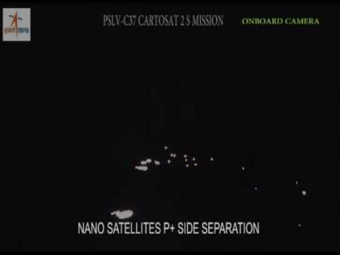
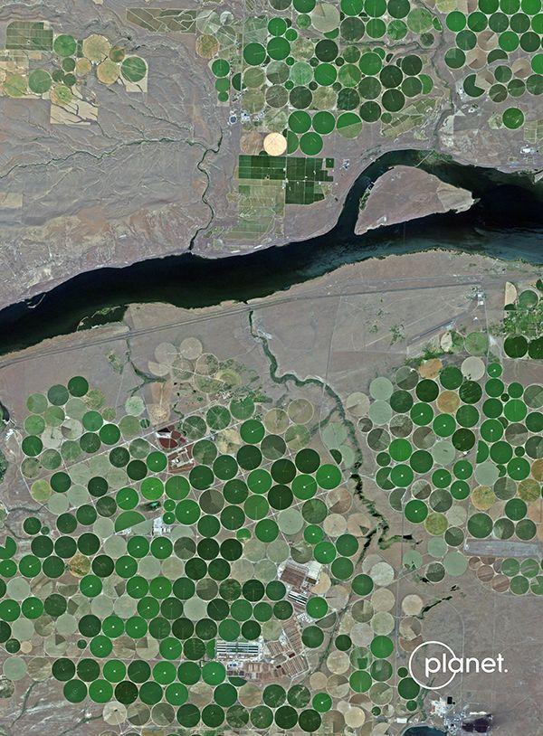
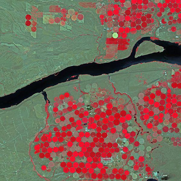
7 SUGAR CANE HARVESTING Rio Grande 2016 JAN MAR 18 24

8 SUGAR CANE HARVESTING Rio Grande 2016 JAN MAR 18 24


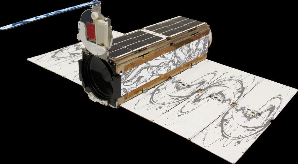
9 END-TO-END SYSTEM s Satellites Ground stations of Virtual Machines 475KM 9 7TB Sun Synchronous Orbit Sites Downlinked Daily API & GUI Planet Explorer, Developer Tools and Third-party Applications

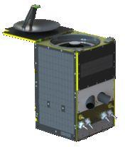
10 Planet is 5 companies in one Satellite design and manufacturing Ground stations Mission control Image processing Software South Passage, Australia

11 AGILE AEROSPACE
12
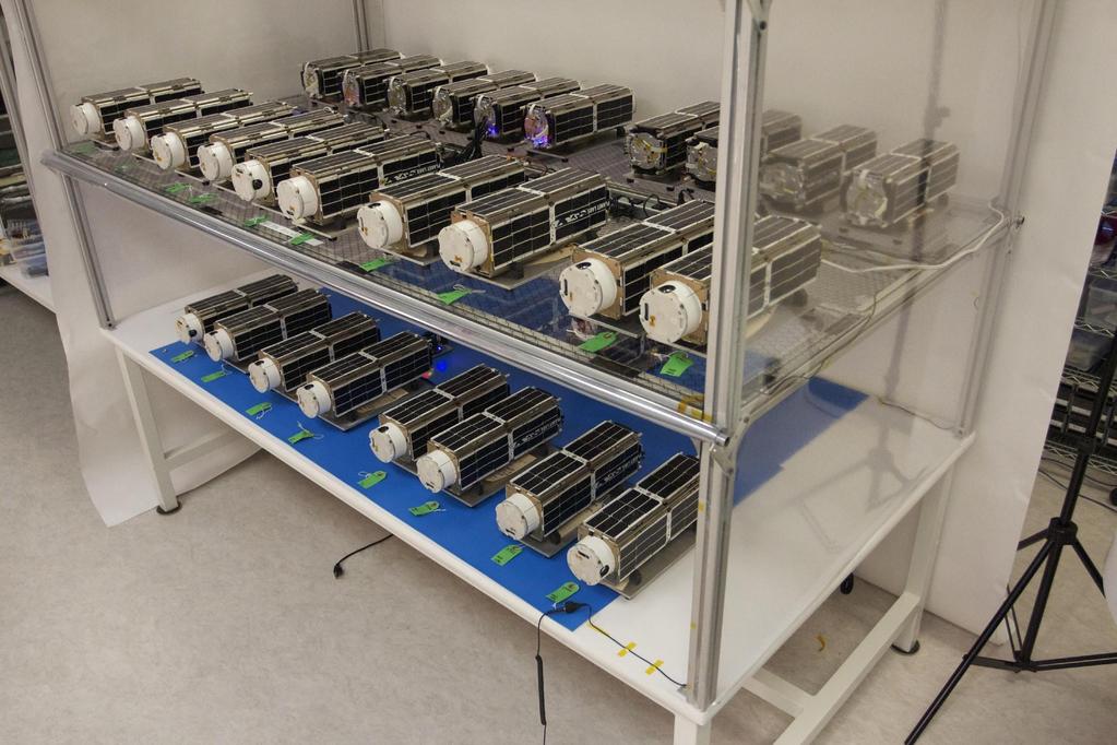
13
 14th of February,")
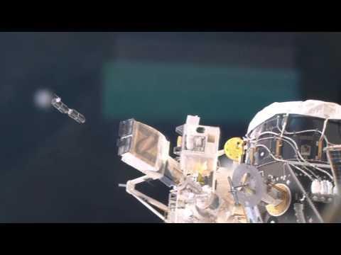
14 LAUNCH & MISSIONS PSLV (88 doves) 14th of February, 2017
15
 28th of October,")
16 LAUNCH & MISSIONS Antares (26 doves) 28th of October, 2014

17 LAUNCH & MISSIONS

18 LAUNCH & MISSIONS


19 ON BOARD SOFTWARE
20 BUILD 7 Build 7 launched after just 2 years of development was Planet s first mass-produced satellite. It consisted of a custom telescope mated to an 11-megapixel CCD camera. FEB NOV SEP 4

21 BUILD 10 Build 10 introduced an improved carbon-fiber telescope and horizon sensors for more precise attitude control. These innovations resulted in a sharper image, increased signal to noise, and more usable pixels. FEB NOV SEP 4

22 BUILD 13 Build 13 is Planet s most advanced satellite. It employs a 2nd-generation custom telescope, 29 megapixel camera, and star tracker. Together, these enhancements resulted in a greatly increased field-of-view and better edge-to-edge sharpness. In addition, a field programmable gate array processes data onboard, allowing the high throughput necessary for collecting near infrared data. FEB NOV SEP 4
23 RGB + NIR CAPABILITY


24 PLANET S CONSTELLATIONS RapidEye Satellites PlanetScope Build 13 Satellites 7 6 SkySat More to be launched in 2017

25 SAMPLE IMAGERY SkySat A: Frankfurt, Germany


26 IMAGE PROCESSING 100m individual images in RGB from doves ~40m RE Images Flatfield Correction Radiometric Calibration Orthorectification Colour Correction Publication Data collection Cloud Platform + Planet Explorer Planet Data API Third Party Applications

27 DELIVERY Reference application: Planet Explorer Delivery via API Search Preview Download API responses are GeoJSON & imagery via GeoTIFF Jeddah, Saudi Arabia

28
 LANDSAT 8")
29 PLANET IMAGERY 4-Band RGB & NIR 3.5m 13-Band, Multispectral & SWIR 10m-60m SENTINEL-2 11-Band, Multispectral, & Thermal IR 15m-30m (100m) LANDSAT 8 PLANETSCOPE 4-Band RGB & NIR.78m-2.07m SKYSAT 5-Band RGB, NIR & Red Edge 6.5m RAPIDEYE

30 What does it mean to have an monitoring constellation? No need for tasking Always on Captures images before events occur Lake Tuborg, Canada May 30, 2015

31 PULAU PINI, INDONESIA Undated Google Earth Image

32 PULAU PINI, INDONESIA May 16, 2016 Logging Roads


33 PULAU PINI, INDONESIA June 22, 2016 Logging Roads

34 SAN GABRIEL WILDFIRES San Gabriel Mountains 2016 JUN 4 22

35 SAN GABRIEL WILDFIRES San Gabriel Mountains Vegetation - dense - moderate - sparse - bare 2016 JUN 4 22

36 SAN GABRIEL WILDFIRES San Gabriel Mountains Fire retardant lines are in red 2016 JUN 4 22

37 SAN GABRIEL WILDFIRES San Gabriel Mountains False Color Composite reveals burn scars 2016 JUN 4 22

38 Lets users think about Earth Observation imagery with a new dimension... Planet imagery has temporal resolution Think of imagery in a time series Large ML training data set Desert Patterns, Saudi Arabia May 30, 2016
39 PLANESNET


40 OPEN CALIFORNIA Full archive of CA imagery available to anyone PlanetScope RapidEye Landsat Sentinel Sign up at: planet.com/explorer Photo placement area (place the photo over the gray box)

41 Developer documentation: Interactive Jupyter notebooks: Python Client Library: Javascript Client Library: Lake Saint Pierre, Canada April 14, 2016
PLANET IMAGERY PRODUCT SPECIFICATIONS PLANET.COM
 PLANET IMAGERY PRODUCT SPECIFICATIONS SUPPORT@PLANET.COM PLANET.COM LAST UPDATED JANUARY 2018 TABLE OF CONTENTS LIST OF FIGURES 3 LIST OF TABLES 4 GLOSSARY 5 1. OVERVIEW OF DOCUMENT 7 1.1 Company Overview
Regulatory Perspectives for NewSpace in Canada
 Regulatory Perspectives for NewSpace in Canada Feb 24, 2017 Mike Safyan Director of Launch & Regulatory Affairs Planet History The Dove Satellite Planet Satellite Fleet CONSTELLATION DOVE RAPIDEYE Constellation
PLANET IMAGERY PRODUCT SPECIFICATION: PLANETSCOPE & RAPIDEYE
 PLANET IMAGERY PRODUCT SPECIFICATION: PLANETSCOPE & RAPIDEYE LAST UPDATED OCTOBER 2016 SALES@PLANET.COM PLANET.COM Table of Contents LIST OF FIGURES 3 LIST OF TABLES 3 GLOSSARY 5 1. OVERVIEW OF DOCUMENT
Aral Sea profile Selection of area 24 February April May 1998
 250 km Aral Sea profile 1960 1960 1985 1986 1987 1988 1989 1990 1991 1992 1993 1994 1995 1996 1997 1998 2010? Selection of area Area of interest Kzyl-Orda Dried seabed 185 km Syrdarya river Aral Sea Salt
Sensor resolutions from space: the tension between temporal, spectral, spatial and swath. David Bruce UniSA and ISU
 Sensor resolutions from space: the tension between temporal, spectral, spatial and swath David Bruce UniSA and ISU 1 Presentation aims 1. Briefly summarize the different types of satellite image resolutions
Sentinel-2 Products and Algorithms
 Sentinel-2 Products and Algorithms Ferran Gascon (Sentinel-2 Data Quality Manager) Workshop Preparations for Sentinel 2 in Europe, Oslo 26 November 2014 Sentinel-2 Mission Mission Overview Products and
Remote Sensing Platforms
 Remote Sensing Platforms Remote Sensing Platforms - Introduction Allow observer and/or sensor to be above the target/phenomena of interest Two primary categories Aircraft Spacecraft Each type offers different
PLANET IMAGERY PRODUCT SPECIFICATION: PLANETSCOPE & RAPIDEYE
 PLANET IMAGERY PRODUCT SPECIFICATION: PLANETSCOPE & RAPIDEYE LAST UPDATED FEBRUARY 2017 SALES@PLANET.COM PLANET.COM Table of Contents LIST OF FIGURES 3 LIST OF TABLES 3 GLOSSARY 5 1. OVERVIEW OF DOCUMENT
On the use of water color missions for lakes in 2021
 Lakes and Climate: The Role of Remote Sensing June 01-02, 2017 On the use of water color missions for lakes in 2021 Cédric G. Fichot Department of Earth and Environment 1 Overview 1. Past and still-ongoing
Sources of Geographic Information
 Sources of Geographic Information Data properties: Spatial data, i.e. data that are associated with geographic locations Data format: digital (analog data for traditional paper maps) Data Inputs: sampled
Lecture 6: Multispectral Earth Resource Satellites. The University at Albany Fall 2018 Geography and Planning
 Lecture 6: Multispectral Earth Resource Satellites The University at Albany Fall 2018 Geography and Planning Outline SPOT program and other moderate resolution systems High resolution satellite systems
Planet Labs Inc 2017 Page 2
 SKYSAT IMAGERY PRODUCT SPECIFICATION: ORTHO SCENE LAST UPDATED JUNE 2017 SALES@PLANET.COM PLANET.COM Disclaimer This document is designed as a general guideline for customers interested in acquiring Planet
9/12/2011. Training Course Remote Sensing Basic Theory & Image Processing Methods September 2011
 Training Course Remote Sensing Basic Theory & Image Processing Methods 19 23 September 2011 Popular Remote Sensing Sensors & their Selection Michiel Damen (September 2011) damen@itc.nl 1 Overview Low resolution
GROßFLÄCHIGE UND HOCHFREQUENTE BEOBACHTUNG VON AGRARFLÄCHEN DURCH OPTISCHE SATELLITEN (RAPIDEYE, LANDSAT 8, SENTINEL-2)
") GROßFLÄCHIGE UND HOCHFREQUENTE BEOBACHTUNG VON AGRARFLÄCHEN DURCH OPTISCHE SATELLITEN (RAPIDEYE, LANDSAT 8, SENTINEL-2) Karsten Frotscher Produktmanager Landwirtschaft Slide 1 A Couple Of Words About The
GROßFLÄCHIGE UND HOCHFREQUENTE BEOBACHTUNG VON AGRARFLÄCHEN DURCH OPTISCHE SATELLITEN (RAPIDEYE, LANDSAT 8, SENTINEL-2) Karsten Frotscher Produktmanager Landwirtschaft Slide 1 A Couple Of Words About The
Satellite Imagery and Remote Sensing. DeeDee Whitaker SW Guilford High EES & Chemistry
 Satellite Imagery and Remote Sensing DeeDee Whitaker SW Guilford High EES & Chemistry whitakd@gcsnc.com Outline What is remote sensing? How does remote sensing work? What role does the electromagnetic
Inter-Calibration of the RapidEye Sensors with Landsat 8, Sentinel and SPOT
 Inter-Calibration of the RapidEye Sensors with Landsat 8, Sentinel and SPOT Dr. Andreas Brunn, Dr. Horst Weichelt, Dr. Rene Griesbach, Dr. Pablo Rosso Content About Planet Project Context (Purpose and
29 th Annual Louisiana RS/GIS Workshop April 23, 2013 Cajundome Convention Center Lafayette, Louisiana
 Landsat Data Continuity Mission 29 th Annual Louisiana RS/GIS Workshop April 23, 2013 Cajundome Convention Center Lafayette, Louisiana http://landsat.usgs.gov/index.php# Landsat 5 Sets Guinness World Record
Satellite Remote Sensing: Earth System Observations
 Satellite Remote Sensing: Earth System Observations Land surface Water Atmosphere Climate Ecosystems 1 EOS (Earth Observing System) Develop an understanding of the total Earth system, and the effects of
CHAPTER 7: Multispectral Remote Sensing
 CHAPTER 7: Multispectral Remote Sensing REFERENCE: Remote Sensing of the Environment John R. Jensen (2007) Second Edition Pearson Prentice Hall Overview of How Digital Remotely Sensed Data are Transformed
The studies began when the Tiros satellites (1960) provided man s first synoptic view of the Earth s weather systems.
 provided man s first synoptic view of the Earth s weather systems.") Remote sensing of the Earth from orbital altitudes was recognized in the mid-1960 s as a potential technique for obtaining information important for the effective use and conservation of natural resources.
Remote sensing of the Earth from orbital altitudes was recognized in the mid-1960 s as a potential technique for obtaining information important for the effective use and conservation of natural resources.
Module 3 Introduction to GIS. Lecture 8 GIS data acquisition
 Module 3 Introduction to GIS Lecture 8 GIS data acquisition GIS workflow Data acquisition (geospatial data input) GPS Remote sensing (satellites, UAV s) LiDAR Digitized maps Attribute Data Management Data
Remote Sensing Platforms
 Types of Platforms Lighter-than-air Remote Sensing Platforms Free floating balloons Restricted by atmospheric conditions Used to acquire meteorological/atmospheric data Blimps/dirigibles Major role - news
remote sensing? What are the remote sensing principles behind these Definition
 Introduction to remote sensing: Content (1/2) Definition: photogrammetry and remote sensing (PRS) Radiation sources: solar radiation (passive optical RS) earth emission (passive microwave or thermal infrared
Introduction to KOMPSAT
 Introduction to KOMPSAT September, 2016 1 CONTENTS 01 Introduction of SIIS 02 KOMPSAT Constellation 03 New : KOMPSAT-3 50 cm 04 New : KOMPSAT-3A 2 KOMPSAT Constellation KOMPSAT series National space program
NON-PHOTOGRAPHIC SYSTEMS: Multispectral Scanners Medium and coarse resolution sensor comparisons: Landsat, SPOT, AVHRR and MODIS
 NON-PHOTOGRAPHIC SYSTEMS: Multispectral Scanners Medium and coarse resolution sensor comparisons: Landsat, SPOT, AVHRR and MODIS CLASSIFICATION OF NONPHOTOGRAPHIC REMOTE SENSORS PASSIVE ACTIVE DIGITAL
Introduction to Remote Sensing Fundamentals of Satellite Remote Sensing. Mads Olander Rasmussen
 Introduction to Remote Sensing Fundamentals of Satellite Remote Sensing Mads Olander Rasmussen (mora@dhi-gras.com) 01. Introduction to Remote Sensing DHI What is remote sensing? the art, science, and technology
Lesson 3: Working with Landsat Data
 Lesson 3: Working with Landsat Data Lesson Description The Landsat Program is the longest-running and most extensive collection of satellite imagery for Earth. These datasets are global in scale, continuously
Rapideye (2008 -> ) Not just another high resolution satellite sensor. 5 satellites RapidEye constellation. 5 million km² daily collection capacity
 Not just another high resolution satellite sensor. 5 satellites RapidEye constellation. 5 million km² daily collection capacity") Rapideye (2008 -> ) Not just another high resolution satellite sensor 5 satellites RapidEye constellation 5 million km² daily collection capacity Price: $1.40 / sq km ($2.50 rectified) Orbit: http://www.youtube.com/watch?feature=player_embedded&v=ovpulctoqgs
Rapideye (2008 -> ) Not just another high resolution satellite sensor 5 satellites RapidEye constellation 5 million km² daily collection capacity Price: $1.40 / sq km ($2.50 rectified) Orbit: http://www.youtube.com/watch?feature=player_embedded&v=ovpulctoqgs
The Landsat Legacy: Monitoring a Changing Earth. U.S. Department of the Interior U.S. Geological Survey
 The Landsat Legacy: Monitoring a Changing Earth U.S. Department of the Interior U.S. Geological Survey Tom Loveland March 17, 2001 Landsat Science Mission Change is occurring at rates unprecedented in
IKONOS High Resolution Multispectral Scanner Sensor Characteristics
 High Spatial Resolution and Hyperspectral Scanners IKONOS High Resolution Multispectral Scanner Sensor Characteristics Launch Date View Angle Orbit 24 September 1999 Vandenberg Air Force Base, California,
Monitoring Natural Disasters with Small Satellites Smart Satellite Based Geospatial System for Environmental Protection
 Monitoring Natural Disasters with Small Satellites Smart Satellite Based Geospatial System for Environmental Protection Krištof Oštir, Space-SI, Slovenia Contents Natural and technological disasters Current
PLANET SURFACE REFLECTANCE PRODUCT
 PLANET SURFACE REFLECTANCE PRODUCT FEBRUARY 2018 SUPPORT@PLANET.COM PLANET.COM VERSION 1.0 TABLE OF CONTENTS 3 Product Description 3 Atmospheric Correction Methodology 5 Product Limitations 6 Product Assessment
NASA Missions and Products: Update. Garik Gutman, LCLUC Program Manager NASA Headquarters Washington, DC
 NASA Missions and Products: Update Garik Gutman, LCLUC Program Manager NASA Headquarters Washington, DC 1 JPSS-2 (NOAA) SLI-TBD Formulation in 2015 RBI OMPS-Limb [[TSIS-2]] [[TCTE]] Land Monitoring at
A CubeSat-Based Optical Communication Network for Low Earth Orbit
 A CubeSat-Based Optical Communication Network for Low Earth Orbit Richard Welle, Alexander Utter, Todd Rose, Jerry Fuller, Kristin Gates, Benjamin Oakes, and Siegfried Janson The Aerospace Corporation
Update on Landsat Program and Landsat Data Continuity Mission
 Update on Landsat Program and Landsat Data Continuity Mission Dr. Jeffrey Masek LDCM Deputy Project Scientist NASA GSFC, Code 923 November 21, 2002 Draft LDCM Implementation Phase RFP Overview Page 1 Celebrate!
Copernicus Introduction Lisbon, Portugal 13 th & 14 th February 2014
 Copernicus Introduction Lisbon, Portugal 13 th & 14 th February 2014 Contents Introduction GMES Copernicus Six thematic areas Infrastructure Space data An introduction to Remote Sensing In-situ data Applications
How to Access Imagery and Carry Out Remote Sensing Analysis Using Landsat Data in a Browser
 How to Access Imagery and Carry Out Remote Sensing Analysis Using Landsat Data in a Browser Including Introduction to Remote Sensing Concepts Based on: igett Remote Sensing Concept Modules and GeoTech
Introduction to Remote Sensing
 Introduction to Remote Sensing Spatial, spectral, temporal resolutions Image display alternatives Vegetation Indices Image classifications Image change detections Accuracy assessment Satellites & Air-Photos
ROLE OF SATELLITE DATA APPLICATION IN CADASTRAL MAP AND DIGITIZATION OF LAND RECORDS DR.T. RAVISANKAR GROUP HEAD (LRUMG) RSAA/NRSC/ISRO /DOS HYDERABAD
 RSAA/NRSC/ISRO /DOS HYDERABAD") ROLE OF SATELLITE DATA APPLICATION IN CADASTRAL MAP AND DIGITIZATION OF LAND RECORDS DR.T. RAVISANKAR GROUP HEAD (LRUMG) RSAA/NRSC/ISRO /DOS HYDERABAD WORKSHOP on Best Practices under National Land Records
ROLE OF SATELLITE DATA APPLICATION IN CADASTRAL MAP AND DIGITIZATION OF LAND RECORDS DR.T. RAVISANKAR GROUP HEAD (LRUMG) RSAA/NRSC/ISRO /DOS HYDERABAD WORKSHOP on Best Practices under National Land Records
Application of Satellite Remote Sensing for Natural Disasters Observation
 Application of Satellite Remote Sensing for Natural Disasters Observation Prof. Krištof Oštir, Ph.D. University of Ljubljana Faculty of Civil and Geodetic Engineering Outline Earth observation current
Operational Space-Based Imaging Systems
 Operational Space-Based Imaging Systems R E M O T E S E N S I N G & G E O S PAT I A L A N A LY S I S L A B D O I : 2 0 A U G U S T, 2 0 1 6 Earth Observation Systems U.S. or foreign government systems
9/12/2011. Training Course Remote Sensing Basic Theory & Image Processing Methods September 2011
 Training Course Remote Sensing Basic Theory & Image Processing Methods 19 23 September 2011 Remote Sensing Platforms Michiel Damen (September 2011) damen@itc.nl 1 Overview Platforms & missions aerial surveys
EnMAP Environmental Mapping and Analysis Program
 EnMAP Environmental Mapping and Analysis Program www.enmap.org Mathias Schneider Mission Objectives Regular provision of high-quality calibrated hyperspectral data Precise measurement of ecosystem parameters
Land Cover Analysis to Determine Areas of Clear-cut and Forest Cover in Olney, Montana. Geob 373 Remote Sensing. Dr Andreas Varhola, Kathry De Rego
 1 Land Cover Analysis to Determine Areas of Clear-cut and Forest Cover in Olney, Montana Geob 373 Remote Sensing Dr Andreas Varhola, Kathry De Rego Zhu an Lim (14292149) L2B 17 Apr 2016 2 Abstract Montana
The studies began when the Tiros satellites (1960) provided man s first synoptic view of the Earth s weather systems.
 provided man s first synoptic view of the Earth s weather systems.") Remote sensing of the Earth from orbital altitudes was recognized in the mid-1960 s as a potential technique for obtaining information important for the effective use and conservation of natural resources.
Remote sensing of the Earth from orbital altitudes was recognized in the mid-1960 s as a potential technique for obtaining information important for the effective use and conservation of natural resources.
Lecture 13: Remotely Sensed Geospatial Data
 Lecture 13: Remotely Sensed Geospatial Data A. The Electromagnetic Spectrum: The electromagnetic spectrum (Figure 1) indicates the different forms of radiation (or simply stated light) emitted by nature.
RECONNAISSANCE PAYLOADS FOR RESPONSIVE SPACE
 3rd Responsive Space Conference RS3-2005-5004 RECONNAISSANCE PAYLOADS FOR RESPONSIVE SPACE Charles Cox Stanley Kishner Richard Whittlesey Goodrich Optical and Space Systems Division Danbury, CT Frederick
Results of Hodoyoshi-3 and -4 Earth Observation Missions
 Trans. JSASS Aerospace Tech. Japan Vol. 4, No. ists3, pp. Pn_5-Pn_22, 26 Results of Hodoyoshi-3 and -4 Earth Observation Missions By Yoshihide AOYANAI, ) Akira IWASAKI, ) Shinichi NAKASUKA, ) Takuji EBINUMA,
Important Missions. weather forecasting and monitoring communication navigation military earth resource observation LANDSAT SEASAT SPOT IRS
 Fundamentals of Remote Sensing Pranjit Kr. Sarma, Ph.D. Assistant Professor Department of Geography Mangaldai College Email: prangis@gmail.com Ph. No +91 94357 04398 Remote Sensing Remote sensing is defined
XSAT Ground Segment at CRISP
 XSAT Ground Segment at CRISP LIEW Soo Chin Head of Research, CRISP http://www.crisp.nus.edu.sg 5 th JPTM for Sentinel Asia Step-2, 14-16 Nov 2012, Daejeon, Korea Centre for Remote Imaging, Sensing and
The PROBA Missions Design Capabilities for Autonomous Guidance, Navigation and Control. Jean de Lafontaine President
 The PROBA Missions Design Capabilities for Autonomous Guidance, Navigation and Control Jean de Lafontaine President Overview of NGC NGC International Inc (holding company) NGC Aerospace Ltd Sherbrooke,
Japan's Greenhouse Gases Observation from Space
 1 Workshop on EC CEOS Priority on GHG Monitoring Japan's Greenhouse Gases Observation from Space 18 June, 2018@Ispra, Italy Masakatsu NAKAJIMA Japan Aerospace Exploration Agency Development and Operation
Lab 1 Introduction to ENVI
 Remote sensing for agricultural applications: principles and methods (2013-2014) Instructor: Prof. Tao Cheng (tcheng@njau.edu.cn) Nanjing Agricultural University Lab 1 Introduction to ENVI April 1 st,
NORMALIZING ASTER DATA USING MODIS PRODUCTS FOR LAND COVER CLASSIFICATION
 NORMALIZING ASTER DATA USING MODIS PRODUCTS FOR LAND COVER CLASSIFICATION F. Gao a, b, *, J. G. Masek a a Biospheric Sciences Branch, NASA Goddard Space Flight Center, Greenbelt, MD 20771, USA b Earth
Reaching for the Stars
 Satellite Research Centre Reaching for the Stars Kay-Soon Low Centre Director School of Electrical & Electronic Engineering Nanyang Technological University 1 Satellite Programs @SaRC 2013 2014 2015 2016
Commissioning of the NigeriaSat-2 High Resolution Imaging Mission
 Changing the economics of space Commissioning of the NigeriaSat-2 High Resolution Imaging Mission Phil Davies (presenting) SSTL Francis Chizea - NASRDA Andrew Cawthorne SSTL Andrew Carrel - SSTL Luis Gomes
Grant Boxer Consultant Geologist March 10th 2014 (Updated Nov 2014)
") Grant Boxer Consultant Geologist March 10th 2014 (Updated Nov 2014) Work flow for Landsat 8 Landgate Data Selecting and processing basic data Importing into MapInfo Applications SLIP Portal WMS access
Grant Boxer Consultant Geologist March 10th 2014 (Updated Nov 2014) Work flow for Landsat 8 Landgate Data Selecting and processing basic data Importing into MapInfo Applications SLIP Portal WMS access
Futrajaya, Malaysia JULY 12, Jeong Heon SONG. Korea Aerospace Research Institution
 J P T M 2 0 1 1 Futrajaya, Malaysia JULY 12, 2011 Jeong Heon SONG Korea Aerospace Research Institution Outline Contribution of KARI Sentinel Asia / Data Provider Node International Charter KARI Space Activities
University of Texas at San Antonio EES 5053 Term Project CORRELATION BETWEEN NDVI AND SURFACE TEMPERATURES USING LANDSAT ETM + IMAGERY NEWFEL MAZARI
 University of Texas at San Antonio EES 5053 Term Project CORRELATION BETWEEN NDVI AND SURFACE TEMPERATURES USING LANDSAT ETM + IMAGERY NEWFEL MAZARI Introduction and Objectives The present study is a correlation
Geo/SAT 2 INTRODUCTION TO REMOTE SENSING
 Geo/SAT 2 INTRODUCTION TO REMOTE SENSING Paul R. Baumann, Professor Emeritus State University of New York College at Oneonta Oneonta, New York 13820 USA COPYRIGHT 2008 Paul R. Baumann Introduction Remote
Global hot spot monitoring with Landsat 8 and Sentinel-2. Soushi Kato Atsushi Oda Ryosuke Nakamura (AIST)
") Global hot spot monitoring with Landsat 8 and Sentinel-2 Soushi Kato Atsushi Oda Ryosuke Nakamura (AIST) Motivation for Detecting Hot Spots Hotspot detection using satellite data To monitor wildfire and
Global hot spot monitoring with Landsat 8 and Sentinel-2 Soushi Kato Atsushi Oda Ryosuke Nakamura (AIST) Motivation for Detecting Hot Spots Hotspot detection using satellite data To monitor wildfire and
ANALYSIS OF LAND COVER AND LAND USE CHANGES USING SENTINEL-2 IMAGES
 DOI 10.1515/pesd-2016-0034 PESD, VOL. 10, no. 2, 2016 ANALYSIS OF LAND COVER AND LAND USE CHANGES USING SENTINEL-2 IMAGES Nicoleta Iurist (Dumitrașcu) 1,, Florian Stătescu 2, Iustina Lateș 3 Key words,
Landsat 8 Pansharpen and Mosaic Geomatica 2015 Tutorial
 Landsat 8 Pansharpen and Mosaic Geomatica 2015 Tutorial On February 11, 2013, Landsat 8 was launched adding to the constellation of Earth imaging satellites. It is the seventh satellite to reach orbit
First Exam. Geographers Tools: Gathering Information. Photographs and Imagery. SPIN 2 Image of Downtown Atlanta, GA 1995 REMOTE SENSING 9/19/2016
 First Exam Geographers Tools: Gathering Information Prof. Anthony Grande Hunter College Geography Lecture design, content and presentation AFG 0616. Individual images and illustrations may be subject to
MAPS AND SATELLITE IMAGES TOOLS FOR AN EFFECTIVE MANAGEMENT OF THE HISTORIC CENTER OF SIGHISOARA, AN UNESCO WORLD HERITAGE SITE
 Journal of Young Scientist, Volume VI, 2018 ISSN 2344-1283; ISSN CD-ROM 2344-1291; ISSN Online 2344-1305; ISSN-L 2344 1283 MAPS AND SATELLITE IMAGES TOOLS FOR AN EFFECTIVE MANAGEMENT OF THE HISTORIC CENTER
TopSat: Brief to Ground Segment Coordination. Presenter Ian Pilling. By : W.A. Levett. Co author: E.J. Baxter.
 TopSat: Brief to Ground Segment Coordination Board Presenter Ian Pilling By : W.A. Levett Co author: E.J. Baxter Contents Space Division overview The TopSat mission Overview Development Programme Launch
Introduction of Satellite Remote Sensing
 Introduction of Satellite Remote Sensing Spatial Resolution (Pixel size) Spectral Resolution (Bands) Resolutions of Remote Sensing 1. Spatial (what area and how detailed) 2. Spectral (what colors bands)
Landsat 8. Snabba leveranser av bilder till användarna. Lars-Åke Edgardh. tisdag 9 april 13
 Landsat 8 Snabba leveranser av bilder till användarna Lars-Åke Edgardh Keystone A single system for: Many sensors Many types of clients Hides the complexity of sensors. Specialised on: Services High volume
An Introduction to Remote Sensing & GIS. Introduction
 An Introduction to Remote Sensing & GIS Introduction Remote sensing is the measurement of object properties on Earth s surface using data acquired from aircraft and satellites. It attempts to measure something
A 1m Resolution Camera For Small Satellites
 A 1m Resolution Camera For Small Satellites Paper SSC06-X-5 Presenter: Jeremy Curtis 1 Introduction TopSat launched October 2005 carrying RAL s 2.5m GSD camera into a 686km orbit Built and operated by
Remote Sensing Exam 2 Study Guide
 Remote Sensing Exam 2 Study Guide Resolution Analog to digital Instantaneous field of view (IFOV) f ( cone angle of optical system ) Everything in that area contributes to spectral response mixels Sampling
Spectral Signatures. Vegetation. 40 Soil. Water WAVELENGTH (microns)
") Spectral Signatures % REFLECTANCE VISIBLE NEAR INFRARED Vegetation Soil Water.5. WAVELENGTH (microns). Spectral Reflectance of Urban Materials 5 Parking Lot 5 (5=5%) Reflectance 5 5 5 5 5 Wavelength (nm)
Spectral Signatures % REFLECTANCE VISIBLE NEAR INFRARED Vegetation Soil Water.5. WAVELENGTH (microns). Spectral Reflectance of Urban Materials 5 Parking Lot 5 (5=5%) Reflectance 5 5 5 5 5 Wavelength (nm)
Processing Aster Data for Atmospheric Correction Geomatica 2014 Tutorial
 The Advanced Spaceborne Thermal Emission and Reflection Radiometer (ASTER) sensor is part of five sensor systems on board Terra. Terra is a satellite that was launched on December 18, 1999 at Vandenberg
Atmospheric Correction (including ATCOR)
") Technical Specifications Atmospheric Correction (including ATCOR) The data obtained by optical satellite sensors with high spatial resolution has become an invaluable tool for many groups interested in
Technical Specifications Atmospheric Correction (including ATCOR) The data obtained by optical satellite sensors with high spatial resolution has become an invaluable tool for many groups interested in
John P. Stevens HS: Remote Sensing Test
 Name(s): Date: Team name: John P. Stevens HS: Remote Sensing Test 1 Scoring: Part I - /18 Part II - /40 Part III - /16 Part IV - /14 Part V - /93 Total: /181 2 I. History (3 pts. each) 1. What is the name
THE SPACE TECHNOLOGY RESEARCH VEHICLE 2 MEDIUM WAVE INFRA RED IMAGER
 THE SPACE TECHNOLOGY RESEARCH VEHICLE 2 MEDIUM WAVE INFRA RED IMAGER S J Cawley, S Murphy, A Willig and P S Godfree Space Department The Defence Evaluation and Research Agency Farnborough United Kingdom
Not just another high resolution satellite sensor
 Global Forest Change Published by Hansen, Potapov, Moore, Hancher et al. http://earthenginepartners.appspot.com/science-2013-global-forest Rapideye Not just another high resolution satellite sensor 5 satellites
Geospatial Vision and Policies Korean Industry View 26 November, 2014 SI Imaging Services
 Geospatial Vision and Policies Korean Industry View 26 November, 2014 SI Imaging Services Distribution Limitation, SI Imaging Services Proprietary Data : The data contained in this document, without the
OVERVIEW OF KOMPSAT-3A CALIBRATION AND VALIDATION
 OVERVIEW OF KOMPSAT-3A CALIBRATION AND VALIDATION DooChun Seo 1, GiByeong Hong 1, ChungGil Jin 1, DaeSoon Park 1, SukWon Ji 1 and DongHan Lee 1 1 KARI(Korea Aerospace Space Institute), 45, Eoeun-dong,
of the Small Satellite Mission Systematic Image Processing Eckehard Lorenz, DLR Berlin Ilmenau, Klaus Briess, TU Berlin 49th IWK
 Ilmenau, 27.-30.09. 2004 49th IWK Eckehard Lorenz, DLR Berlin Klaus Briess, TU Berlin Astro- und Feinwerktechnik Adlershof GmbH Systematic Image Processing of the Small Satellite Mission BIRD Optical Information
From Proba-V to Proba-MVA
 From Proba-V to Proba-MVA Fabrizio Niro ESA Sensor Performances Products and Algorithm (SPPA) ESA UNCLASSIFIED - For Official Use Proba-V extension in the Copernicus era Proba-V was designed with the main
Remote Sensing Imagery Support for Burned Area Emergency Response Teams on 2003 Southern California Wildfires
 Burned Area Emergency Response Team Project Report Operations United States Department of Agriculture Forest Service Engineering Remote Sensing Applications Center December 2003 RSAC-2003-RPT1 Remote Sensing
First Exam: Thurs., Sept 28
 8 Geographers Tools: Gathering Information Prof. Anthony Grande Hunter College Geography Lecture design, content and presentation AFG 0917. Individual images and illustrations may be subject to prior copyright.
Some Basic Concepts of Remote Sensing. Lecture 2 August 31, 2005
 Some Basic Concepts of Remote Sensing Lecture 2 August 31, 2005 What is remote sensing Remote Sensing: remote sensing is science of acquiring, processing, and interpreting images and related data that
Downloading and formatting remote sensing imagery using GLOVIS
 Downloading and formatting remote sensing imagery using GLOVIS Students will become familiarized with the characteristics of LandSat, Aerial Photos, and ASTER medium resolution imagery through the USGS
SEN3APP Stakeholder Workshop, Helsinki Yrjö Rauste/VTT Kaj Andersson/VTT Eija Parmes/VTT
 Optical Products from Sentinel-2 and Suomi- NPP/VIIRS SEN3APP Stakeholder Workshop, Helsinki 19.11.2015 Yrjö Rauste/VTT Kaj Andersson/VTT Eija Parmes/VTT Structure of Presentation High-resolution data
Making NDVI Images using the Sony F717 Nightshot Digital Camera and IR Filters and Software Created for Interpreting Digital Images.
 Making NDVI Images using the Sony F717 Nightshot Digital Camera and IR Filters and Software Created for Interpreting Digital Images Draft 1 John Pickle Museum of Science October 14, 2004 Digital Cameras
GMES Sentinel-2. The Optical High Resolution Mission for GMES Operational Services
 GMES Sentinel-2 The Optical High Resolution Mission for GMES Operational Services Philippe Martimort GMES Sentinel-2 Mission and Payload Manager, ESA/ESTEC 15 October 2007, AGRISAR Workshop, Noordwijk
CHARACTERISTICS OF REMOTELY SENSED IMAGERY. Radiometric Resolution
 CHARACTERISTICS OF REMOTELY SENSED IMAGERY Radiometric Resolution There are a number of ways in which images can differ. One set of important differences relate to the various resolutions that images express.
The Nemo Bus: A Third Generation Nanosatellite Bus for Earth Monitoring and Observation
 The Nemo Bus: A Third Generation Nanosatellite Bus for Earth Monitoring and Observation FREDDY M. PRANAJAYA Manager, Advanced Systems Group S P A C E F L I G H T L A B O R A T O R Y University of Toronto
What is Photogrammetry
 Photogrammetry What is Photogrammetry Photogrammetry is the art and science of making accurate measurements by means of aerial photography: Analog photogrammetry (using films: hard-copy photos) Digital
Lecture 7 Earth observation missions
 Remote sensing for agricultural applications: principles and methods (2013-2014) Instructor: Prof. Tao Cheng (tcheng@njau.edu.cn). Nanjing Agricultural University Lecture 7 Earth observation missions May
Multispectral Scanners for Wildland Fire Assessment NASA Ames Research Center Earth Science Division. Bruce Coffland U.C.
 Multispectral Scanners for Wildland Fire Assessment NASA Earth Science Division Bruce Coffland U.C. Santa Cruz Slide Fire Burn Area (MASTER/B200) R 2.2um G 0.87um B 0.65um Airborne Science & Technology
Satellite/Aircraft Imaging Systems Imaging Sensors Standard scanner designs Image data formats
 CEE 6150: Digital Image Processing 1 Satellite/Aircraft Imaging Systems Imaging Sensors Standard scanner designs Image data formats CEE 6150: Digital Image Processing 2 CEE 6150: Digital Image Processing
2017 REMOTE SENSING EVENT TRAINING STRATEGIES 2016 SCIENCE OLYMPIAD COACHING ACADEMY CENTERVILLE, OH
 2017 REMOTE SENSING EVENT TRAINING STRATEGIES 2016 SCIENCE OLYMPIAD COACHING ACADEMY CENTERVILLE, OH This presentation was prepared using draft rules. There may be some changes in the final copy of the
Advanced Optical Satellite (ALOS-3) Overviews
 Overviews") K&C Science Team meeting #24 Tokyo, Japan, January 29-31, 2018 Advanced Optical Satellite (ALOS-3) Overviews January 30, 2018 Takeo Tadono 1, Hidenori Watarai 1, Ayano Oka 1, Yousei Mizukami 1, Junichi
K&C Science Team meeting #24 Tokyo, Japan, January 29-31, 2018 Advanced Optical Satellite (ALOS-3) Overviews January 30, 2018 Takeo Tadono 1, Hidenori Watarai 1, Ayano Oka 1, Yousei Mizukami 1, Junichi
RGB colours: Display onscreen = RGB
 RGB colours: http://www.colorspire.com/rgb-color-wheel/ Display onscreen = RGB DIGITAL DATA and DISPLAY Myth: Most satellite images are not photos Photographs are also 'images', but digital images are
Remote Sensing and GIS
 Remote Sensing and GIS Atmosphere Reflected radiation, e.g. Visible Emitted radiation, e.g. Infrared Backscattered radiation, e.g. Radar (λ) Visible TIR Radar & Microwave 11/9/2017 Geo327G/386G, U Texas,
Pléiades imagery for coastal and inland water applications
 Pléiades imagery for coastal and inland water applications Pléiades 2014-09-08 Quinten Vanhellemont & PONDER project 2017-10-20 dredging ship PONDER SR/00/325 «Ocean colour remote sensing» Remote sensing
Introduction to image processing for remote sensing: Practical examples
 Università degli studi di Roma Tor Vergata Corso di Telerilevamento e Diagnostica Elettromagnetica Anno accademico 2010/2011 Introduction to image processing for remote sensing: Practical examples Dr.