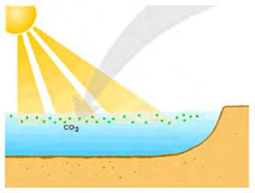
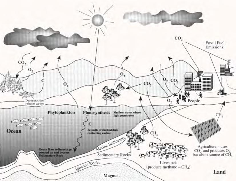
Light penetration within a clear water body. E z = E 0 e -kz
|
|
|
- Kelly Young
- 5 years ago
- Views:
Transcription


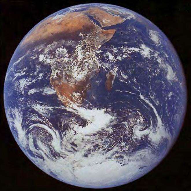
1 THE BLUE PLANET 1
2 2

3 Light penetration within a clear water body E z = E 0 e -kz 3
4 4
5 5
 b chl,loisel and Morel (1998) a chl, Sathyendranath et al.")
6 Pure Seawater Phytoplankton b w 10-2 m -1 b w 10-2 m -1 b w, Morel (1974) a w, Pope and Fry (1997) b chl,loisel and Morel (1998) a chl, Sathyendranath et al. (2001) 6
7 7
8 8
9 9
10 Photosynthesis Ocean Color 10
11 Different pigments absorb at different wavelengths 11
12 12
13 13
14 Instrument Satellite Dates of Operation Spatial Resolution Swath Width CZCS Nimbus-7 10/24/78-6/22/ m 1556 km MOS IRS P3 3/21/96-Present 520 m 200 km MOS Priroda 4/23/96-Present 650 m 85 km OCTS ADEOS 8/17/96-7/1/ m 1400 km SeaWiFS Orbview-2 8/1/97-Present 1100 m 2800 km OCI ROCSAT-1 1/99-Present 800 m 690 km MODIS Terra/Aqua 12/18/99-Present 1000 m 2330 km SENSOR AGENCY SATELLITE LAUNCH DATE COCTS CZI MERIS MMRS MODIS- Aqua MODIS- Terra OCM POLDER-3 SeaWiFS CNSA (China) CNSA (China) ESA (Europe) CONAE (Argentina) NASA (USA) NASA (USA) ISRO (India) CNES (France) NASA (USA) Updated 03/05/2008 SWATH (km) RESOLUTION (m) BANDS SPECTRAL COVERAGE (nm) ORBIT HY-1B (China) 11 Apr ,500 Polar HY-1B (China) 11 Apr Polar ENVISAT (Europe) 1 Mar / Polar SAC-C (Argentina) 21 Nov Polar Aqua (EOS-PM1) 4 May ,385 Polar Terra (EOS-AM1) 18 Dec ,385 Polar IRS-P4 (India) 26 May Polar Parasol 18 Dec Polar OrbView-2 (USA) 1 Aug Polar 14

15 15
16 16
17 17
18 18
19 19
20 PROCESSING ALGORITHMS Based on Gordon et al. (1980) and Gordon et al. (1983) The algorithm used for estimating the pigments content of the ocean from CZCS measurements involves the use of radiance ratios. The general form of the equation is Where log(c) = a + b*log[lw(1)/lw(2)] C is the pigment concentration (mg/m^3) a,b are regression coefficients Lw(1),Lw(2) are the atmospherically corrected radiances for a pair of CZCS channels For CZCS pigments processing, these channel pairs are (443, 550 nm), for C < 1.5 mg/m^3 (520, 550 nm), for C > 1.5 mg/m^3 20


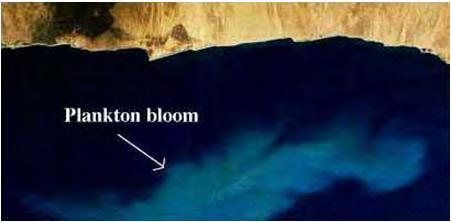
21 Monthly Composite of CZCS During September

 1")

22 Sea-viewing Wide Field-of-view Sensor (SeaWiFS) CZCS BANDS Band Wavelength (nm) Phytoplankton Chl-a 22
23 SeaWiFS ALGORITHMS 23


24 GLOBAL ESTIMATION OF PHYTOPLANKTON CHLOROPHYLL-A USING SEAWIFS DATA 24


25 Launched on December 18, 1999 Launched on May 4,
26 MODIS Technical Specifications Orbit: Scan Rate: 705 km, 10:30 a.m. descending node (Terra) or 1:30 p.m. ascending node (Aqua), sun-synchronous, near-polar, circular 20.3 rpm, cross track Swath Dimensions: Telescope: 2330 km (cross track) by 10 km (along track at nadir) cm diam. off-axis, afocal (collimated), with intermediate field stop Size: 1.0 x 1.6 x 1.0 m Weight: kg Power: W (single orbit average) Data Rate: 10.6 Mbps (peak daytime); 6.1 Mbps (orbital average) Quantization: 12 bits Spatial Resolution: Design Life: 250 m (bands 1-2) 500 m (bands 3-7) 1000 m (bands 8-36) 6 years MODIS BANDS Primary Use Band Bandwidth 1 Spectral Radiance 2 Required SNR 3 Land/Cloud/Aerosols Boundaries Land/Cloud/Aerosols Properties Ocean Color/ Phytoplankton/ Biogeochemistry Atmospheric Water Vapor
![MODIS BANDS Primary Use Band Bandwidth 1 Spectral Radiance 2 Required NE[delta]T(K) 4 Surface/Cloud 20 3.660-3.840 0.45(300K) 0.05 Temperature 21 3.929-3.989 2.38(335K) 2.00 22 3.929-3.989 0.](/docs-images/87/96046807/images/27-0.jpg "67(300K) 0.07 23 4.020-4.080 0.79(300K) 0.07 Atmospheric Temperature Cirrus Clouds Water Vapor 24 4.433-4.498 0.17(250K) 0.25 25 4.482-4.549 0.59(275K) 0.25 26 1.360-1.390 6.00 150(SNR) 27 6.535-6.")
 0.05 Cloud Top Altitude 33 13.185-13.485 4.52(260K) 0.25 34 13.485-13.785 3.76(250K) 0.25 35 13.785-14.085 3.11(240K) 0.25 36 14.085-14.385 2.08(220K) 0.")
27 MODIS BANDS Primary Use Band Bandwidth 1 Spectral Radiance 2 Required NE[delta]T(K) 4 Surface/Cloud (300K) 0.05 Temperature (335K) (300K) (300K) 0.07 Atmospheric Temperature Cirrus Clouds Water Vapor (250K) (275K) (SNR) (240K) (250K) 0.25 Cloud Properties (300K) 0.05 Ozone (250K) 0.25 Surface/Cloud (300K) 0.05 Temperature (300K) 0.05 Cloud Top Altitude (260K) (250K) (240K) (220K) 0.35 Sea Surface Temperature (Celsius Degree) Phytoplankton Chlorophyll-a (mg m^3) 27


28 Weekly MODIS Chlorophyll March 6-13, 2001 Weekly Ocean Net Primary Productivity 28
29 Challenges for Ocean Color in Caribbean Coastal Waters Global problems for ocean color remote sensing are also present in the Caribbean Better understanding of the temporal and spatial variability of inherent and apparent optical properties is needed. Site-specific bio-optical algorithms are required to better estimates the concentration of Chlorophyll-a and Suspended Sediments. CDOM and suspended sediments are seasonally produced by rivers discharge and their correlation controls the bio-optical variability. Photosynthetic picoplankton, like cyanobacteria, are competing with large phytoplankton for the quality and quantity of light. Current satellite sensors do not provide accurate estimates of water quality parameters in coastal areas due to all the above problems. 29

30 But, three unique challenges for remote sensing are also found in Caribbean coastal waters 1. Size of the coastal regions-requires sensors with very high spatial resolution. 2. Low concentration of the parameters-requires sensors with very high S/N ratio. 3. Short-term effects of dramatic seasonal events, like hurricanes, on land-sea interactions-requires sensors with high temporal resolution. PHYTOPLANKTON DYNAMICS AFFECTED BY LARGE REGIONAL RIVERS AS DETECTED BY SEAWIFS 30
 Reflectance")

31 But, SeaWiFS images fail in coastal waters with local rivers Low Chl for developing bio-optical algorithms (also the number of data points are limited) Reflectance ratio (R443/R550) y = x R 2 = Chlorophyll-a (ug/l) 31


32 Low reflectance signal and no fluorescence peak PHYTOPLANKTON DYNAMICS AFFECTED BY HURRICANES September 19 September 25 October 15 32

33 Opportunities for Ocean Color in Caribbean Coastal Waters Easy access to coastal waters Mayaguez Bay at Western P.R. Deep and Clear Waters Añasco River Sewage Outfall Yaguez River Guanajibo River Shallow and Clear Waters with Coral Reefs It is an accessible natural laboratory with large spatial and temporal variations. It is affected by rivers discharge and anthropogenic effects. Past and current research has provided excellent background information. Its is an ideal place to develop and test remote sensing techniques for coastal waters. 33


34 Good sampling equipment for sensors validation and algorithms development New algorithms for MODIS [Chlorophyll-a] = Empirical algorithm 500 m resolution [Chl-a]= *(B3/B4) [Chlorophyll-a] = OC3 MODIS algorithm 1 km resolution 34


35 SATELLITE DATA COLLECTION BY THE UPRM-TCESS SPACE INFORMATION LABORATORY L-BAND ANTENNA Orbview 2 NOAA 14/16 35


36 X-BAND ANTENNA RADARSAT LANDSAT-7 AQUA TERRA UPRM Station Viewing Area 36


37 PHYTOPLANKTON DYNAMICS AFFECTED BY COASTAL UPWELLING AVHRR Sea Surface Temperature SeaWiFS Chlorophyll-a Airborne Sensors AOCI 90 s ATLAS 2004 AVIRIS
")

38 Empirical Algorithm to estimate Suspended Sediments in Mayaguez Bay using AVIRIS SS (mg/l) = (R777) Where R777 = AVIRIS Reflectance at 777 nm Sensors with high spatial resolution 38


39 Read Chapter 19 and answer the review questions 1, 4, and 9 (at the end of the chapter). 39
Light penetration within a clear water body. E z = E 0 e -kz
 THE BLUE PLANET 1 2 Light penetration within a clear water body E z = E 0 e -kz 3 4 5 6 Pure Seawater Phytoplankton b w 10-2 m -1 b w 10-2 m -1 b w, Morel (1974) a w, Pope and Fry (1997) b chl,loisel and
Available Ocean Color Satellite Imagery
 Available Ocean Color Satellite Imagery Mati Kahru Scripps Institution of Oceanography UCSD, La Jolla, CA 92093-0218, USA mkahru@ucsd.edu also at WimSoft, http://www.wimsoft.com Email: wim@wimsoft.com
The Moderate Resolution Imaging Spectroradiometer (MODIS): Potential Applications for Climate Change and Modeling Studies
: Potential Applications for Climate Change and Modeling Studies") The Moderate Resolution Imaging Spectroradiometer (MODIS): Potential Applications for Climate Change and Modeling Studies Menas Kafatos, CEOSR, George Mason University Jim McManus, CEOSR, GMU and GES DISC
The Moderate Resolution Imaging Spectroradiometer (MODIS): Potential Applications for Climate Change and Modeling Studies Menas Kafatos, CEOSR, George Mason University Jim McManus, CEOSR, GMU and GES DISC
Lecture 6: Multispectral Earth Resource Satellites. The University at Albany Fall 2018 Geography and Planning
 Lecture 6: Multispectral Earth Resource Satellites The University at Albany Fall 2018 Geography and Planning Outline SPOT program and other moderate resolution systems High resolution satellite systems
On the use of water color missions for lakes in 2021
 Lakes and Climate: The Role of Remote Sensing June 01-02, 2017 On the use of water color missions for lakes in 2021 Cédric G. Fichot Department of Earth and Environment 1 Overview 1. Past and still-ongoing
Remote Sensing for Resource Management
 Remote Sensing for Resource Management Ebenezer Nyadjro US Naval Research Lab/UNO RMU Summer Program (July 31-AUG 4, 2017) Motivation Polluted Pra River Motivation. 3 Motivation Polluted Pra River Motivation.
MERIS data access over diagnostic sites for calibration and validation purposes
 MERIS data access over diagnostic sites for calibration and validation purposes Philippe Goryl ESA / ESRIN Philippe.Goryl@esa.int Carsten Brockman Brockman Consult Workshop on Inter-Comparison of Large
3/31/03. ESM 266: Introduction 1. Observations from space. Remote Sensing: The Major Source for Large-Scale Environmental Information
 Remote Sensing: The Major Source for Large-Scale Environmental Information Jeff Dozier Observations from space Sun-synchronous polar orbits Global coverage, fixed crossing, repeat sampling Typical altitude
GOCI Status and Cooperation with CoastColour Project
 GOCI Status and Cooperation with CoastColour Project Joo-Hyung RYU Contribution from : KOSC colleaques Nov. 17, 2010 World 1 st GOCI/COMS Launch Campaign Launch Date : June 27 2010 Launch Vehicle : Ariane-V
MERIS instrument. Muriel Simon, Serco c/o ESA
 MERIS instrument Muriel Simon, Serco c/o ESA Workshop on Sustainable Development in Mountain Areas of Andean Countries Mendoza, Argentina, 26-30 November 2007 ENVISAT MISSION 2 Mission Chlorophyll case
Workshop on Practical Applications of MODIS Data in Australia
 Workshop on Practical Applications of MODIS Data in Australia Leeuwin Centre, Floreat WA November 26-29, 2002 Liam Gumley Space Science and Engineering Center University of Wisconsin-Madison Introduction
Coral Reef Remote Sensing
 Coral Reef Remote Sensing Spectral, Spatial, Temporal Scaling Phillip Dustan Sensor Spatial Resolutio n Number of Bands Useful Bands coverage cycle Operation Landsat 80m 2 2 18 1972-97 Thematic 30m 7
IKONOS High Resolution Multispectral Scanner Sensor Characteristics
 High Spatial Resolution and Hyperspectral Scanners IKONOS High Resolution Multispectral Scanner Sensor Characteristics Launch Date View Angle Orbit 24 September 1999 Vandenberg Air Force Base, California,
XSAT Ground Segment at CRISP
 XSAT Ground Segment at CRISP LIEW Soo Chin Head of Research, CRISP http://www.crisp.nus.edu.sg 5 th JPTM for Sentinel Asia Step-2, 14-16 Nov 2012, Daejeon, Korea Centre for Remote Imaging, Sensing and
Sustained Ocean Color Research and Operations
 Sustained Ocean Color Research and Operations What are the minimum requirements to continue the SeaWiFS/MODIS time-series? Based on a National Research Council report by the Ocean Studies Board May 2011
9/12/2011. Training Course Remote Sensing Basic Theory & Image Processing Methods September 2011
 Training Course Remote Sensing Basic Theory & Image Processing Methods 19 23 September 2011 Popular Remote Sensing Sensors & their Selection Michiel Damen (September 2011) damen@itc.nl 1 Overview Low resolution
NON-PHOTOGRAPHIC SYSTEMS: Multispectral Scanners Medium and coarse resolution sensor comparisons: Landsat, SPOT, AVHRR and MODIS
 NON-PHOTOGRAPHIC SYSTEMS: Multispectral Scanners Medium and coarse resolution sensor comparisons: Landsat, SPOT, AVHRR and MODIS CLASSIFICATION OF NONPHOTOGRAPHIC REMOTE SENSORS PASSIVE ACTIVE DIGITAL
CHAPTER 7: Multispectral Remote Sensing
 CHAPTER 7: Multispectral Remote Sensing REFERENCE: Remote Sensing of the Environment John R. Jensen (2007) Second Edition Pearson Prentice Hall Overview of How Digital Remotely Sensed Data are Transformed
Jeffrey H. Bowles, Wesley J. Moses, Gia M. Lamela, Richard Mied, Karen W. Patterson, and Ellen J. Wagner
 1 Jeffrey H. Bowles, Wesley J. Moses, Gia M. Lamela, Richard Mied, Karen W. Patterson, and Ellen J. Wagner and, Washington, D.C. from Center for Advanced Land Management Information Technologies (CALMIT),
The studies began when the Tiros satellites (1960) provided man s first synoptic view of the Earth s weather systems.
 provided man s first synoptic view of the Earth s weather systems.") Remote sensing of the Earth from orbital altitudes was recognized in the mid-1960 s as a potential technique for obtaining information important for the effective use and conservation of natural resources.
Remote sensing of the Earth from orbital altitudes was recognized in the mid-1960 s as a potential technique for obtaining information important for the effective use and conservation of natural resources.
Remote Sensing. Division C. Written Exam
 Remote Sensing Division C Written Exam Team Name: Team #: Team Members: _ Score: /132 A. Matching (10 points) 1. Nadir 2. Albedo 3. Diffraction 4. Refraction 5. Spatial Resolution 6. Temporal Resolution
Recent developments in Deep Blue satellite aerosol data products from NASA GSFC
 Recent developments in Deep Blue satellite aerosol data products from NASA GSFC Andrew M. Sayer, N. Christina Hsu (PI), Corey Bettenhausen, Myeong-Jae Jeong Climate & Radiation Laboratory, NASA Goddard
The Global Imager (GLI)
") The Global Imager (GLI) Launch : Dec.14, 2002 Initial check out : to Apr.14, 2003 (~L+4) First image: Jan.25, 2003 Second image: Feb.6 and 7, 2003 Calibration and validation : to Dec.14, 2003(~L+4) for
The Global Imager (GLI) Launch : Dec.14, 2002 Initial check out : to Apr.14, 2003 (~L+4) First image: Jan.25, 2003 Second image: Feb.6 and 7, 2003 Calibration and validation : to Dec.14, 2003(~L+4) for
The mission concept includes eight visible-to-near-infrared bands,, and a centered at Korea.
 eostationary cean olor mager : ommunication cean and eteorological atellite It shall be operated in a mode onboard its COMS. The mission concept includes eight visible-to-near-infrared bands,, and a centered
Fundamentals of Remote Sensing
 Climate Variability, Hydrology, and Flooding Fundamentals of Remote Sensing May 19-22, 2015 GEO-Latin American & Caribbean Water Cycle Capacity Building Workshop Cartagena, Colombia 1 Objective To provide
Earth s Gravitational Pull
 Satellite & Sensors Space Countries Earth s Gravitational Pull The Earth's gravity pulls everything toward the Earth. In order to orbit the Earth, the velocity of a body must be great enough to overcome
New capabilities in Earth Observation for agriculture
 New capabilities in Earth Observation for agriculture Prof. Katarzyna Dabrowska-Zielinska Head of Remote Sensing Department Institute of Geodesy and Cartography Modzelewskiego 27 Street 02-679 Warsaw Poland
Geostationary satellites
 Polar satellites 800 km. 99 relative to the Equator S-N during ascending leg & N-S during descending leg Each orbit 100 minutes 14 orbits a day. Sun-Synchronous provides consistent lighting of Earth-scan
The OCR-VC addresses the following strategic objectives towards these goals:
 TERMS OF REFERENCE FOR THE CEOS OCEAN COLOR RADIOMETRY VIRTUAL CONSTELLATION VERSION 3.1 LAST MODIFIED: 19 DECEMBER 2013 CONSTELLATION NAME: Ocean Color Radiometry Virtual Constellation (OCR-VC) MISSION
Present and future of marine production in Boka Kotorska
 Present and future of marine production in Boka Kotorska First results from satellite remote sensing for the breeding areas of filter feeders in the Bay of Kotor INTRODUCTION Environmental monitoring is
Copernicus Introduction Lisbon, Portugal 13 th & 14 th February 2014
 Copernicus Introduction Lisbon, Portugal 13 th & 14 th February 2014 Contents Introduction GMES Copernicus Six thematic areas Infrastructure Space data An introduction to Remote Sensing In-situ data Applications
746A27 Remote Sensing and GIS. Multi spectral, thermal and hyper spectral sensing and usage
 746A27 Remote Sensing and GIS Lecture 3 Multi spectral, thermal and hyper spectral sensing and usage Chandan Roy Guest Lecturer Department of Computer and Information Science Linköping University Multi
NASA OBPG Satellite Ocean Color Update
 NASA OBPG Satellite Ocean Color Update Bryan Franz and the Ocean Biology Processing Group NASA Goddard Space Flight Center IOCS Meeting Ocean Color Research Team Meeting 18 May 2017, Lisbon, Portugal NASA
Lecture 7 Earth observation missions
 Remote sensing for agricultural applications: principles and methods (2013-2014) Instructor: Prof. Tao Cheng (tcheng@njau.edu.cn). Nanjing Agricultural University Lecture 7 Earth observation missions May
Sources of Geographic Information
 Sources of Geographic Information Data properties: Spatial data, i.e. data that are associated with geographic locations Data format: digital (analog data for traditional paper maps) Data Inputs: sampled
An Introduction to Remote Sensing & GIS. Introduction
 An Introduction to Remote Sensing & GIS Introduction Remote sensing is the measurement of object properties on Earth s surface using data acquired from aircraft and satellites. It attempts to measure something
DEVELOPING AN OCEAN COLOUR SERVICE SUPPORTING GLOBAL CARBON-CYCLE RESEARCH AND OPERATIONAL OCEANOGRAPHY
 DEVELOPING AN OCEAN COLOUR SERVICE SUPPORTING GLOBAL CARBON-CYCLE RESEARCH AND OPERATIONAL OCEANOGRAPHY Odile Fanton d'andon 1, Samantha Lavender 2, Antoine Mangin 1 and Simon Pinnock 3 (1) ACRI-ST, France
REMOTE SENSING FOR FLOOD HAZARD STUDIES.
 REMOTE SENSING FOR FLOOD HAZARD STUDIES. OPTICAL SENSORS. 1 DRS. NANETTE C. KINGMA 1 Optical Remote Sensing for flood hazard studies. 2 2 Floods & use of remote sensing. Floods often leaves its imprint
Multiplatform Remote Sensing for Coral Reef Community Assessment
 Multiplatform Remote Sensing for Coral Reef Community Assessment Quinta Reunión Nacional de Percepción Remota y Sistemas de Información Geográfica en Puerto Rico September 27, 2007 Roy A. Armstrong, Ph.
COMBINATION OF LIDAR, MODIS AND SEAWIFS SENSORS FOR SIMULTANEOUS CHLOROPHYLL MONITORING
 EARSeL eproceedings 3, 1/2004 8 COMBINATION OF LIDAR, MODIS AND SEAWIFS SENSORS FOR SIMULTANEOUS CHLOROPHYLL MONITORING Luca Fiorani 1, Roberto Barbini 1, Francesco Colao 1, Luigi De Dominicis 1, Roberta
Some Basic Concepts of Remote Sensing. Lecture 2 August 31, 2005
 Some Basic Concepts of Remote Sensing Lecture 2 August 31, 2005 What is remote sensing Remote Sensing: remote sensing is science of acquiring, processing, and interpreting images and related data that
Status of MODIS, VIIRS, and OLI Sensors
 Status of MODIS, VIIRS, and OLI Sensors Xiaoxiong (Jack) Xiong, Jim Butler, and Brian Markham Code 618.0 NASA/GSFC, Greenbelt, MD 20771, USA Acknowledgements: NASA MODIS Characterization Support Team (MCST)
VENµS: A Joint French Israeli Earth Observation Scientific Mission with High Spatial and Temporal Resolution Capabilities
 VENµS: A Joint French Israeli Earth Observation Scientific Mission with High Spatial and Temporal Resolution Capabilities G. Dedieu 1, A. Karnieli 2, O. Hagolle 3, H. Jeanjean 3, F. Cabot 3, P. Ferrier
Current and Future Meteorological Satellite Program of China
 Current and Future Meteorological Satellite Program of China ZHANG Wenjian, DONG Chaohua XU Jianmin, YANG Jun China Meteorological Administration May 30, 2005 Beijing, CHINA Outline of the Presentation
Passive Microwave Sensors LIDAR Remote Sensing Laser Altimetry. 28 April 2003
 Passive Microwave Sensors LIDAR Remote Sensing Laser Altimetry 28 April 2003 Outline Passive Microwave Radiometry Rayleigh-Jeans approximation Brightness temperature Emissivity and dielectric constant
Time Trend Evaluations of Absolute Accuracies for PRISM and AVNIR-2
 The 3 rd ALOS Joint PI Symposium, Kona, Hawaii, US Nov. 9-13, 2009 Time Trend Evaluations of Absolute Accuracies for PRISM and AVNIR-2 Takeo Tadono*, Masanobu Shimada*, Hiroshi Murakami*, Junichi Takaku**,
CHAPTER --'3 DATA DESCRIPTION
 CHAPTER --'3 DATA DESCRIPTION 37 3.1 INTRODUCTION In chapter 2 different techniques used for the study of polar cryosphere like passive and active remote sensing, altimetry and scatterometry are described.
Using Ground Targets for Sensor On orbit Calibration Support
 EOS Using Ground Targets for Sensor On orbit Calibration Support X. Xiong, A. Angal, A. Wu, and T. Choi MODIS Characterization Support Team (MCST), NASA/GSFC G. Chander SGT/USGS EROS CEOS Libya 4 Workshop,
Geospatial Vision and Policies Korean Industry View 26 November, 2014 SI Imaging Services
 Geospatial Vision and Policies Korean Industry View 26 November, 2014 SI Imaging Services Distribution Limitation, SI Imaging Services Proprietary Data : The data contained in this document, without the
PILOTING A DECISION SUPPORT TOOL (DST) FOR MAPPING CYANOBACTERIAL HARMFUL ALGAL BLOOMS (CHABS) TO SUPPORT PUBLIC HEALTH AND RESOURCE MANAGEMENT.
 FOR MAPPING CYANOBACTERIAL HARMFUL ALGAL BLOOMS (CHABS) TO SUPPORT PUBLIC HEALTH AND RESOURCE MANAGEMENT.") PILOTING A DECISION SUPPORT TOOL (DST) FOR MAPPING CYANOBACTERIAL HARMFUL ALGAL BLOOMS (CHABS) TO SUPPORT PUBLIC HEALTH AND RESOURCE MANAGEMENT. Nathan Torbick, Applied Geosolutions Scott Stoodley, Director,
PILOTING A DECISION SUPPORT TOOL (DST) FOR MAPPING CYANOBACTERIAL HARMFUL ALGAL BLOOMS (CHABS) TO SUPPORT PUBLIC HEALTH AND RESOURCE MANAGEMENT. Nathan Torbick, Applied Geosolutions Scott Stoodley, Director,
SEA GRASS MAPPING FROM SATELLITE DATA
 JSPS National Coordinators Meeting, Coastal Marine Science 19 20 May 2008 Melaka SEA GRASS MAPPING FROM SATELLITE DATA Mohd Ibrahim Seeni Mohd, Nurul Hazrina Idris, Samsudin Ahmad 1. Introduction PRESENTATION
Japan's Greenhouse Gases Observation from Space
 1 Workshop on EC CEOS Priority on GHG Monitoring Japan's Greenhouse Gases Observation from Space 18 June, 2018@Ispra, Italy Masakatsu NAKAJIMA Japan Aerospace Exploration Agency Development and Operation
MULTI-TEMPORAL SATELLITE IMAGES WITH BATHYMETRY CORRECTION FOR MAPPING AND ASSESSING SEAGRASS BED CHANGES IN DONGSHA ATOLL
 MULTI-TEMPORAL SATELLITE IMAGES WITH BATHYMETRY CORRECTION FOR MAPPING AND ASSESSING SEAGRASS BED CHANGES IN DONGSHA ATOLL Chih -Yuan Lin and Hsuan Ren Center for Space and Remote Sensing Research, National
From Proba-V to Proba-MVA
 From Proba-V to Proba-MVA Fabrizio Niro ESA Sensor Performances Products and Algorithm (SPPA) ESA UNCLASSIFIED - For Official Use Proba-V extension in the Copernicus era Proba-V was designed with the main
Introduction to Remote Sensing
 Introduction to Remote Sensing Daniel McInerney Urban Institute Ireland, University College Dublin, Richview Campus, Clonskeagh Drive, Dublin 14. 16th June 2009 Presentation Outline 1 2 Spaceborne Sensors
Theme: ocean colour observations from the geostationary orbit
 A new IOCCG working group Theme: ocean colour observations from the geostationary orbit Today (Nov 1 st, 2008):1 st Working group meeting, with the following goals: - Members of the WG meet and know better
Futrajaya, Malaysia JULY 12, Jeong Heon SONG. Korea Aerospace Research Institution
 J P T M 2 0 1 1 Futrajaya, Malaysia JULY 12, 2011 Jeong Heon SONG Korea Aerospace Research Institution Outline Contribution of KARI Sentinel Asia / Data Provider Node International Charter KARI Space Activities
Brief introduction on Chinese ocean colour satellite missions
 卫星海洋环境动力学国家重点实验室 Brief introduction on Chinese ocean colour satellite missions Zhihua Mao, Delu Pan State Key Laboratory of Satellite Ocean Environment Dynamics, Second Institute of Oceanography, SOA 卫星海洋环境动力学国家重点实验室国家海洋局第二海洋研究所
Sea to Sky: The NASA Plankton, Aerosol, Cloud, ocean Ecosystem (PACE) mission
 mission") Sea to Sky: The NASA Plankton, Aerosol, Cloud, ocean Ecosystem (PACE) mission Jeremy Werdell PACE Project Scientist NASA Goddard Space Flight Center Robert H. Goddard Memorial Symposium 9 March 2017, Greenbelt,
Sea to Sky: The NASA Plankton, Aerosol, Cloud, ocean Ecosystem (PACE) mission Jeremy Werdell PACE Project Scientist NASA Goddard Space Flight Center Robert H. Goddard Memorial Symposium 9 March 2017, Greenbelt,
Introduction to Remote Sensing Fundamentals of Satellite Remote Sensing. Mads Olander Rasmussen
 Introduction to Remote Sensing Fundamentals of Satellite Remote Sensing Mads Olander Rasmussen (mora@dhi-gras.com) 01. Introduction to Remote Sensing DHI What is remote sensing? the art, science, and technology
Improved monitoring of bio-optical processes in coastal and inland waters using high spatial resolution channels on SNPP-VIIRS sensor
 Improved monitoring of bio-optical processes in coastal and inland waters using high spatial resolution channels on SNPP-VIIRS sensor Ryan A. Vandermeulen* a, Robert Arnone a, Sherwin Ladner b, Paul Martinolich
The Sounding Instruments on Second Generation of Chinese Meteorological Satellite FY-3
 The Sounding Instruments on Second Generation of Chinese Meteorological Satellite FY-3 DONG Chaohua ZHANG Wenjian National Satellite Meteorological Center China Meteorological Administration Beijing 100081,
Pléiades imagery for coastal and inland water applications
 Pléiades imagery for coastal and inland water applications Pléiades 2014-09-08 Quinten Vanhellemont & PONDER project 2017-10-20 dredging ship PONDER SR/00/325 «Ocean colour remote sensing» Remote sensing
Suomi NPP VIIRS Calibration/ Validation Progress Update
 Suomi NPP VIIRS Calibration/ Validation Progress Update C. Cao 1, Q. Liu 2, S. Blonski 2, X. Shao 2, and S. Uprety 3 1 NOAA/NESDIS Center for Satellite Applications and Research 2 ESSIC, University of
35017 Las Palmas de Gran Canaria, Spain Santa Cruz de Tenerife, Spain ABSTRACT
 Atmospheric correction models for high resolution WorldView-2 multispectral imagery: A case study in Canary Islands, Spain. J. Martin* a F. Eugenio a, J. Marcello a, A. Medina a, Juan A. Bermejo b a Institute
Remote Sensing Platforms
 Types of Platforms Lighter-than-air Remote Sensing Platforms Free floating balloons Restricted by atmospheric conditions Used to acquire meteorological/atmospheric data Blimps/dirigibles Major role - news
Radiometric Validation of Sentinel-3
 Radiometric Validation of Sentinel-3 by Kevin Ruddick, Dimitry Van Der Zande and Quinten Vanhellemont (RBINS, ODNature, REMSEM) Sentinel-2 Radiometric Validation of Sentinel-3 by Kevin Ruddick, Dimitry
Radiometric performance of Second Generation Global Imager (SGLI) using integrating sphere
 using integrating sphere") Radiometric performance of Second Generation Global Imager (SGLI) using integrating sphere Taichiro Hashiguchi, Yoshihiko Okamura, Kazuhiro Tanaka, Yukinori Nakajima Japan Aerospace Exploration Agency
Radiometric performance of Second Generation Global Imager (SGLI) using integrating sphere Taichiro Hashiguchi, Yoshihiko Okamura, Kazuhiro Tanaka, Yukinori Nakajima Japan Aerospace Exploration Agency
WATER SERVICE - COASTAL PRODUCTS PRODUCT DESCRIPTION
 WATER SERVICE - COASTAL PRODUCTS PRODUCT DESCRIPTION Delivery 30.01.2015 Kerstin Stelzer, Ana Ruescas, Uwe Lange - Brockmann Consult GmbH Overview The products within the water quality service provide
Applications of Remote Sensing for Lake Basin Management
 Applications of Remote Sensing for Lake Basin Management Shane Bradt Introduction Remote sensing is the use of a sensor to measure characteristics of an object without physically touching the object. While
AVHRR/3 Operational Calibration
 AVHRR/3 Operational Calibration Jörg Ackermann, Remote Sensing and Products Division 1 Workshop`Radiometric Calibration for European Missions, 30/31 Aug. 2017`,Frascati (EUM/RSP/VWG/17/936014) AVHRR/3
SATELLITE OCEANOGRAPHY
 SATELLITE OCEANOGRAPHY An Introduction for Oceanographers and Remote-sensing Scientists I. S. Robinson Lecturer in Physical Oceanography Department of Oceanography University of Southampton JOHN WILEY
typical spectral signatures of photosynthetically active and non-photosynthetically active vegetation (Beeri et al., 2007)
") typical spectral signatures of photosynthetically active and non-photosynthetically active vegetation (Beeri et al., 2007) Xie, Y. et al. J Plant Ecol 2008 1:9-23; doi:10.1093/jpe/rtm005 Copyright restrictions
typical spectral signatures of photosynthetically active and non-photosynthetically active vegetation (Beeri et al., 2007) Xie, Y. et al. J Plant Ecol 2008 1:9-23; doi:10.1093/jpe/rtm005 Copyright restrictions
Aral Sea profile Selection of area 24 February April May 1998
 250 km Aral Sea profile 1960 1960 1985 1986 1987 1988 1989 1990 1991 1992 1993 1994 1995 1996 1997 1998 2010? Selection of area Area of interest Kzyl-Orda Dried seabed 185 km Syrdarya river Aral Sea Salt
Remote Sensing Mapping of Turbidity in the Upper San Francisco Estuary. Francine Mejia, Geography 342
 Remote Sensing Mapping of Turbidity in the Upper San Francisco Estuary Francine Mejia, Geography 342 Introduction The sensitivity of reflectance to sediment, chlorophyll a, and colored DOM (CDOM) in the
Status of Aqua MODIS Reflective Solar Bands Calibration and Performance
 EOS Status of Aqua MODIS Reflective Solar Bands Calibration and Performance Jack Xiong NASA GSFC, Greenbelt, MD 20771, USA A. Angal, H. Chen, X. Geng, D. Link, Y. Li, and A. Wu SSAI, 10210 Greenbelt Road,
Increased potential to monitor water quality in the near-shore environment with Landsat s next-generation satellite
 Increased potential to monitor water quality in the near-shore environment with Landsat s next-generation satellite Aaron D. Gerace John R. Schott Robert Nevins Increased potential to monitor water quality
Maximize Utilization of the performance of EOSs and strengthen. The First Steering Committee Secretariat JAXA
 Maximize Utilization of the performance of EOSs and strengthen cooperation among DPN/DAN The First Steering Committee Secretariat JAXA ALOS 2 observation is strong tool for disaster monitoring Wide area/range
INF-GEO Introduction to remote sensing
 INF-GEO 4310 Introduction to remote sensing Anne Solberg (anne@ifi.uio.no) Satellites, orbits and repeat cycles Optical remote sensings Based on a tutorial adapted from Canadian Center for Remote Sensing,
1. INTRODUCTION. GOCI : Geostationary Ocean Color Imager
 1. INTRODUCTION The Korea Ocean Research and Development Institute (KORDI) releases an announcement of opportunity (AO) to carry out scientific research for the utilization of GOCI data. GOCI is the world
QUANTITATIVE GLOBAL MAPPING OF TERRESTRIAL VEGETATION PHOTOSYNTHESIS: THE FLUORESCENCE EXPLORER (FLEX) MISSION
 MISSION") 2017 IEEE International Geoscience and Remote Sensing Symposium July 23 28, 2017 Fort Worth, Texas, USA Session MO3.L12 - International Spaceborne Imaging Spectroscopy Missions: Updates and News I QUANTITATIVE
2017 IEEE International Geoscience and Remote Sensing Symposium July 23 28, 2017 Fort Worth, Texas, USA Session MO3.L12 - International Spaceborne Imaging Spectroscopy Missions: Updates and News I QUANTITATIVE
Remote Sensing Platforms
 Remote Sensing Platforms Remote Sensing Platforms - Introduction Allow observer and/or sensor to be above the target/phenomena of interest Two primary categories Aircraft Spacecraft Each type offers different
NRL SSC HICO Article for Oceans 09 Conference
 NRL SSC HICO Article for Oceans 09 Conference Title: The Hyperspectral Imager for the Coastal Ocean (HICO): Sensor and Data Processing Overview Abstract M.D. Lewis, R.W. Gould, Jr., R.A. Arnone, P.E. Lyon,
Introduction of GLI level-1 products
 Introduction of GLI level-1 products JAXA EORC December 24, 2003 http://www.eoc.jaxa.jp/homepage.html 1. JAXA Global Imager The JAXA Global Imager (GLI) orbit and observation method are outlined below.
Exelis Visual Information Solutions
 Craig Cowan, Defence and Security Business Development craig.cowan@exelisinc.com www.exelisvis.eu Exelis Visual Information Solutions Hyperspectral Imagery Exploitation Sensors Symposium, Stockholm 10
Chapter 8. Remote sensing
 1. Remote sensing 8.1 Introduction 8.2 Remote sensing 8.3 Resolution 8.4 Landsat 8.5 Geostationary satellites GOES 8.1 Introduction What is remote sensing? One can describe remote sensing in different
Inter comparison of Terra and Aqua MODIS Reflective Solar Bands Using Suomi NPP VIIRS
 Inter comparison of Terra and Aqua Reflective Solar Bands Using Suomi NPP VIIRS Slawomir Blonski, * Changyong Cao, Sirish Uprety, ** and Xi Shao * NOAA NESDIS Center for Satellite Applications and Research
Wesley J. Moses., Washington, D.C., USA.
 Wesley J. Moses, Washington, D.C., USA. Sensor Characteristics 2 Spatial Resolution Spectral Resolution Signal-to-Noise Ratio Temporal Resolution Spatial Resolution 3 What is the dominant spatial scale
Sentinel-3 OLCI and SLSTR
 Sentinel-3 OLCI and SLSTR Craig Donlon ESA/ESTEC, Mission Science Division B. Berruti, J. Frerick, C. Mavrocordatos, J. Nieke, H. Rebhan, J. Stroede and the S3 Team, European Space Agency, ESTEC, Keplerlaan
Detection of Change with Time Series of Satellite Images
 Detection of Change with Time Series of Satellite Images Please see \Course\4\Detection_of_Change.pdf on DVD or http://www.wimsoft.com/course/4/detection_of_change.pdf Detection of change is a hot topic
GEOSS Americas/Caribbean Remote Sensing Workshop November Lab 2 Investigating Cloud Phase, NDVI, Ocean Color and Sea Surface Temperatures
 GEOSS Americas/Caribbean Remote Sensing Workshop 26-30 November 2007 Lab 2 Investigating Cloud Phase, NDVI, Ocean Color and Sea Surface Temperatures Kathleen Strabala kathy.strabala@ssec.wisc.edu Table:
Multi-sensor data base over desert sites for calibration purpose. P. Henry ¹, X. Briottet ², C. Miesch ², F. Cabot ¹ ¹CNES, ²ONERA
 Multi-sensor data base over desert sites for calibration purpose P. Henry ¹, X. Briottet ², C. Miesch ², F. Cabot ¹ ¹CNES, ²ONERA Outline Introduction SADE database Calibration method Some results Desert
Automatic processing to restore data of MODIS band 6
 Automatic processing to restore data of MODIS band 6 --Final Project for ECE 533 Abstract An automatic processing to restore data of MODIS band 6 is introduced. For each granule of MODIS data, 6% of the
Advanced Optical Satellite (ALOS-3) Overviews
 Overviews") K&C Science Team meeting #24 Tokyo, Japan, January 29-31, 2018 Advanced Optical Satellite (ALOS-3) Overviews January 30, 2018 Takeo Tadono 1, Hidenori Watarai 1, Ayano Oka 1, Yousei Mizukami 1, Junichi
K&C Science Team meeting #24 Tokyo, Japan, January 29-31, 2018 Advanced Optical Satellite (ALOS-3) Overviews January 30, 2018 Takeo Tadono 1, Hidenori Watarai 1, Ayano Oka 1, Yousei Mizukami 1, Junichi
Intersatellite Calibration of infrared sensors onboard Indian Geostationary Satellites using LEO Hyperspectral Observations
 Updates from GSICS members and Observers Indian Space Research Organisation (ISRO) Intersatellite Calibration of infrared sensors onboard Indian Geostationary Satellites using LEO Hyperspectral Observations
Microwave Sensors Subgroup (MSSG) Report
 Report") Microwave Sensors Subgroup (MSSG) Report CEOS WGCV-35 May 13-17, 2013, Shanghai, China DONG, Xiaolong, MSSG Chair CAS Key Laboratory of Microwave Remote Sensing National Space Science Center Chinese Academy
Microwave Sensors Subgroup (MSSG) Report CEOS WGCV-35 May 13-17, 2013, Shanghai, China DONG, Xiaolong, MSSG Chair CAS Key Laboratory of Microwave Remote Sensing National Space Science Center Chinese Academy
Overview of the Small Optical TrAnsponder (SOTA) Project
 Project") Overview of the Small Optical TrAnsponder (SOTA) Project Space Communications Laboratory Wireless Networks Research Center National Institute of Information and Communications Technology (NICT) Satellite
Overview of the Small Optical TrAnsponder (SOTA) Project Space Communications Laboratory Wireless Networks Research Center National Institute of Information and Communications Technology (NICT) Satellite
The coastal challenge. Dr Samantha Lavender
 The coastal challenge Dr Samantha Lavender SEOES & Marine Institute, University of Plymouth ARGANS Limited Tamar Science Park, Plymouth s.lavender@plymouth.ac.uk samantha.lavender@argans.co.uk http://www.research.plymouth.ac.uk/geomatics/
The studies began when the Tiros satellites (1960) provided man s first synoptic view of the Earth s weather systems.
 provided man s first synoptic view of the Earth s weather systems.") Remote sensing of the Earth from orbital altitudes was recognized in the mid-1960 s as a potential technique for obtaining information important for the effective use and conservation of natural resources.
Remote sensing of the Earth from orbital altitudes was recognized in the mid-1960 s as a potential technique for obtaining information important for the effective use and conservation of natural resources.
Shallow Water Remote Sensing
 Shallow Water Remote Sensing John Hedley, IOCCG Summer Class 2018 Overview - different methods and applications Physics-based model inversion methods High spatial resolution imagery and Sentinel-2 Bottom