Shallow Water Remote Sensing
|
|
|
- Rafe Davidson
- 5 years ago
- Views:
Transcription


1 Shallow Water Remote Sensing John Hedley, IOCCG Summer Class 2018 Overview - different methods and applications Physics-based model inversion methods High spatial resolution imagery and Sentinel-2 Bottom mapping Satellite derived bathymetry (SDB) Sun-glint correction of high spatial resolution images Model inversion methods and uncertainty propagation
 Applications Spatial")

2 Objectives of shallow water remote sensing Bottom mapping - corals, seagrasses, macroalgae Water optical properties Bathymetry (depth) Applications Spatial ecology (science) MPA design (resource mapping) Assessing ecosystem services - coastal protection and stabilisation - fisheries, local subsistence - blue carbon - tourism

3 Applications on coral reefs and similar environments Need higher spatial resolution than typical ocean colour satellites Hedley et al. 2016, Remote Sensing, 8, 118; doi: /rs Hedley et al. 2018, RSE Sentinel-2 special issue (in press, probably)
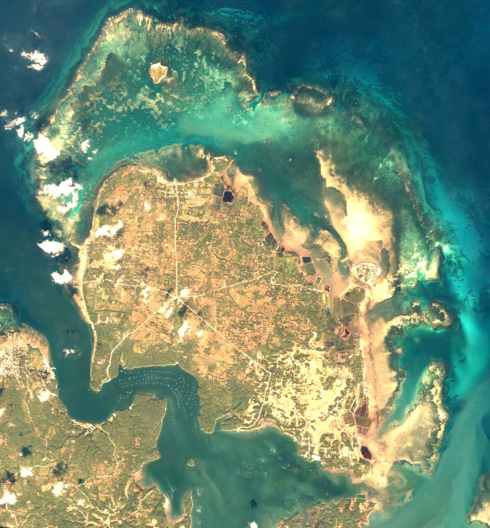
4 WorldView-2 image of Yucatan coast, Mexico (15 Feb 2008) (pixels < 2 m, 8 bands, 5 usable) (c) DigitalGlobe
5 High Spatial Resolution Imagery Pixel size < 5 m Many past and present (archive imagery still available) Pleiades, WorldView-2, 3, QuickBird, GeoEye, IKONOS, RapidEye, Kompsat Typically 4 bands, R, G, B and NIR, but WorldView has 8 bands Pixel size m SPOT (various) Landsat 8 (30 m) Sentinel 2 (10 m in four bands) Notes: Radiometric calibration on commercial satellites is usually not as good as on space agency satellites. For these sensors bands are spectrally wide, not narrow as with ocean colour satellites - not always appropriate to just use centre wavelength - may need to integrate over wavelength
 (pixels < 2 m, 8 bands, 5 usable) (c)")
6 WorldView-2 image of Yucatan coast, Mexico (15 Feb 2008) (pixels < 2 m, 8 bands, 5 usable) (c) DigitalGlobe
 (pixels 10 m, 5 usable bands) ESA /")
7 Sentinel-2 image of Yucatan coast, Mexico (17 April 2018) (pixels 10 m, 5 usable bands) ESA / Copernicus
8 Sentinel 2 - useful bands are at different resolutions Interesting potential issues / artefacts
9 Methods for bottom mapping and/or bathymetry Many and very diverse overlap with terrestrial methods Empirical, image based, requires training from in-situ data Classification, depth invariant indices Bathymetry by regression methods Physics based Radiative transfer model inversion Hybrid Object orientated techniques - classificaton combined with rules which can take data from other remote sensing and physics based methods e.g. depth, wave energy (wind)


 Requires training of points from imagery")
10 Empirical image based methods (e.g. bathymetry) Usually assume exponential attenuation of light with depth (i.e. constant K d ) Requires training of points from imagery (deep water, known depths etc.) Similar methods for water column correction, change detection, etc. Lyzenga 1978 a0, a1, a2 from regression Stumpf et al m0, m1, from regression


11 Benthic classification example, Lizard Island, GBR Depth invarient indices
12 Classification Works by identifying pixels that have similar spectral reflectances Supervised or unsupervised Need for water column correction One method - depth invariant indices only need ratio of attenuation coefficients can extract from image using sand at different depths

13 Sun-glint : different types of glint dependent on spatial scale Large images e.g. MERIS, pixels > 100 m function of solar-view geometry and sea state High spatial resolution, pixels < 10 m individual waves Eg. IKONOS, QuickBird, WorldView 2, Sentinel 2
14 Atmospheric contribution and surface glint 1) Direct Glint 2) Atmospheric Reflectance 3) Part We Want
: 401 88 Result is statistical model of the sea surface: Mean square slope = 0.003 + 0.")
15 Glint prediction and correction - large scale Cox and Munk equations 1950s - based on photographs of surface glitter Many subsequent studies: all agree Cox & Munk (1956) Slopes of the Sea Surface Deduced from Photographs of Sun Glitter. Scripps Inst. Oceanogr. Bull. 6(9): Result is statistical model of the sea surface: Mean square slope = U 10 Sun-glint depends only on: 1) sun position wind speed ms -1 2) sensor position 3) wind speed (and to a small extent wind direction) Statistical description at large scales and open ocean large pixels (100s m) No use for high resolution imagery and shallow areas


16 High spatial resolution Atmospheric contribution may be assumed uniform over the area of interest Surface glint is not uniform
 band to assess the glint Assumption 1 - Glint has a uniform spectral signature Assumption 2 -")

17 Glint correction or deglint of high spatial resolution images Can correct using a Near-Infra Red (NIR) band to assess the glint Assumption 1 - Glint has a uniform spectral signature Assumption 2 - NIR from below the water surface is zero WorldView-2 Image (c) DigitalGlobe pixels 2 m Start with a sample of pixels over deep water, where it is assumed there is no sub-surface variation in reflectance
18 Glint correction or deglint of high spatial resolution images Sample over deep water NIR reflectance (or SWIR) Hedley et al. (2005) International Journal of Remote Sensing 26: and other similar methods - see Kay et al. (2009) Remote Sensing 1:
19 Glint correction or deglint of high spatial resolution images Sample over deep water Before or after atmospheric correction? using minimum NIR reflectance means it probably doesn t matter if you assume uniform atmospheric contribution

20 Before deglint

21 After deglint

22 Deglint example (Landsat 8)

23 Deglint example (Landsat 8)
 Signal to noise issue - take a big signal away to")
 Also, combining noise from two bands - visible band and")
 may be useful Pixel-to-pixel")
24 Note 1: Glint corrected images are quite noisy Before After 1) Signal to noise issue - take a big signal away to leave a small signal, but noise was on the big signal. 2) Also, combining noise from two bands - visible band and NIR band. 3) Process is not perfect - band alignment, etc. Spatial filtering (smoothing) may be useful Pixel-to-pixel noise


25 Note 2: The need for precise band alignment Image bands are not always perfectly spatially aligned Causes serious problems for glint removal algorithm WorldView-2 has various striping artefacts glint corrected band alignment on right side is bad Sentinel-2 detector edges similar problems


26 Note 3: Over-correction when NIR below surface is not zero Assumption of zero NIR from below the water is not valid in shallow water Result is dark halo effect around land features Causes problems for subsequently applied algorithms Before After
 High")


27 1 km Problem of sub-pixel glint (Sentinel-2) High resolution sea surface model Sea surface undulations occur at multiple scales From 100 s metres to millimetres 10 m pixels may still contain slopes contributing to the glint within them 200 m 200 m 3 m 3 m 2 cm 2 cm
28 Specific challenges with Sentinel-2 PIxel size means hard to get a no glint reference The darkest pixels probably still contain some glint So glint correction is incomplete and there remains a glint contribution

29 Specific challenges with Sentinel-2 PIxel size means hard to get a no glint reference Force correction to assume zero NIR reflectance rather than empirical minimum But that assumes NIR really should be zero - i.e. atmospheric correction has removed any aerosol contribution in the NIR - but atmospheric corrections often use NIR to estimate aerosol!
30 Very difficult to disentangle glint from aerosol contribution in Sentinel-2 imagery - without additional information Atmospheric reflectance, Marine 99% RH aerosol model (libradtran) aerosol contribution in NIR and SWIR θ s = 0 θ v = 0 In this plot sun and view are directly overhead (zenith and nadir) Indirect surface reflectance but no direct glint included Top two lines include aerosols, bottom line Rayleigh only SWIR doesn t help much - there still is an aerosol and glint contribution

31 Harmel et al Glint correction for Sentinel-2 Uses SWIR to characterise glint Wavelength dependence based on refractive index of water But still relies on a-priori separation of atmospheric reflectance from surface glint Need this data for atmospheric correction, e.g. from AERONET station. Effectively this adds information to reduce uncertainty between aerosol and glint Harmel T. et al. (2018) Remote Sensing of Environment, 204: doi: /j.rse

32 Inversion methods for shallow water applications
 Applied Optics 44, 3576-3592 2) Semi-analytical models Develop a simpler conceptual model and estimate coefficients or parameters from a physically exact model such as HydroLight Results in a")
33 Shallow water models for R rs 1) HydroLight-EcoLight Build look-up tables for different depths, water column optical properties and bottom reflectances Mobley et al. (2005) Applied Optics 44, ) Semi-analytical models Develop a simpler conceptual model and estimate coefficients or parameters from a physically exact model such as HydroLight Results in a forward model that is faster to compute Lee et al. (1998) Applied Optics 37,
34 Lee et al's semianalytical model for shallow water reflectance remote sensing reflectance bottom reflectance H = depth in metres P = phytoplankton concentration (proxy) G = dissolved organic matter concentration (proxy) X = backscatter Y = (spectral slope of backscatter) is fixed at 1 Also incorporates sun and view zenith angles Various factors derived from HydroLight
35 Inversion of the model This is a forward model it describes what can occur in every individual pixel based on what is in the pixel Six values describe every pixel But we start with this and wish to deduce this 1) Look-Up Tables - just try every combination of P, G, X, H, m, E within their bounds and find which produces the best match for the pixel r rs (λ) 2) Successive approximation technique such as the Levenberg-Marquardt algorithm, keeps adjusting solution to try and improve it.
36 LUT (look-up table) Image pixel Depth, Phytoplankton, CDOM, etc 1 m 0.1 mg m -3 2 m 0.1 mg m -3 3 m 0.1 mg m -3 4 m 0.1 mg m -3 1 m 0.2 mg m -3 2 m 0.2 mg m -3 3 m 0.2 mg m -3 4 m 0.2 mg m -3 MODEL 1 m 0.4 mg m -3 2 m 0.4 mg m -3 3 m 0.4 mg m -3 4 m 0.4 mg m -3 Estimate: Depth = 2 m Phytopankton = 0.2 mg m etc
37 Adaptive LUT construction Hedley et al. 2009, Remote Sens. Environ.

38 Example slice through ALUT structure

39 Uncertainty Propagation Fundamental uncertainty similar spectra from differing parameters


40 Sources of "noise" uncertainty sensor "noise" atmosphere Hyperspectral deep water pixels spectrally correlated model
41 Propagation through inversion Image pixel image noise (multivariate normal) subtract random noise term 20 times 20 reflectance spectra better than direct result spatially smoother invert to retrieve parameter estimations use mean for actual result discard upper and lower tails to give 90% conf. intervals

42 Bathymetry estimation with uncertainty CASI Quickbird 0 m 100 m 200 m 300 m = 90% confidence interval

43 Sentinel-2 bathymetry of Lizard Island (GBR) by model inversion Uses bands 1, 2, 3, 4 and 5 ALUT inversion of Lee et al. equations In-situ echo-sound data for comparison
")
44 Direct result (single inversion) 200 m
45 Mean of 20 noise perturbed results 200 m
46 Single inversion vs. mean of noise perturbed inversions Direct result (single inversion) Mean of 20 noise perturbed results Marginally better statistics, r-squared, mean absolute residual, etc. Cosmetically better (spatially smoother)


47 Shallow (upstanding) coral heads Correctly identified as being shallow even though are dark pixels Benefit of variable bottom reflectance in the forward model.


48 Uncertainty (Quickbird image)


49 Dark patches (coral heads) have relatively higher uncertainty in depth Because there reflectance is similar to that of deeper pixels, within the bounds defined by the noise model


50 Bolinao, Philippines (QuickBird image) Coral reef Fish pens
51 Light absorption due to CDOM Total absorption
52 Light absorption due to CDOM Total absorption

53 Bottom reflectance Use the bathymetry estimate and water optical properties to make water column correction

54 Bottom reflectance Use the bathymetry estimate and water optical properties to make water column correction
 Corals turn temporarily white when stressed by elevated temperature Key")
55 Coral Bleaching (photo, P. Mumby) Corals turn temporarily white when stressed by elevated temperature Key indicator of climate change stresses on coral reefs
56 Coral Bleaching Detection (Sentinel-2)
57 Coral Bleaching Detection (Sentinel-2)


58 Object-orientated / machine learning techniques original image habitat map bathymetry bottom reflectance environmental data (e.g. wave energy, wind)


59 Sen2Coral Toolkit in SNAP Sentinel Application Platform
60 Questions
MULTI-TEMPORAL SATELLITE IMAGES WITH BATHYMETRY CORRECTION FOR MAPPING AND ASSESSING SEAGRASS BED CHANGES IN DONGSHA ATOLL
 MULTI-TEMPORAL SATELLITE IMAGES WITH BATHYMETRY CORRECTION FOR MAPPING AND ASSESSING SEAGRASS BED CHANGES IN DONGSHA ATOLL Chih -Yuan Lin and Hsuan Ren Center for Space and Remote Sensing Research, National
Sun glint correction of very high spatial resolution images
 Sun glint correction of very high spatial resolution images G. Doxani, M. Papadopoulou, P. Lafazani, M. Tsakiri - Strati, E. Mavridou Department of Cadastre, Photogrammetry and Cartography, Aristotle University
Multiplatform Remote Sensing for Coral Reef Community Assessment
 Multiplatform Remote Sensing for Coral Reef Community Assessment Quinta Reunión Nacional de Percepción Remota y Sistemas de Información Geográfica en Puerto Rico September 27, 2007 Roy A. Armstrong, Ph.
On the use of water color missions for lakes in 2021
 Lakes and Climate: The Role of Remote Sensing June 01-02, 2017 On the use of water color missions for lakes in 2021 Cédric G. Fichot Department of Earth and Environment 1 Overview 1. Past and still-ongoing
Jeffrey H. Bowles, Wesley J. Moses, Gia M. Lamela, Richard Mied, Karen W. Patterson, and Ellen J. Wagner
 1 Jeffrey H. Bowles, Wesley J. Moses, Gia M. Lamela, Richard Mied, Karen W. Patterson, and Ellen J. Wagner and, Washington, D.C. from Center for Advanced Land Management Information Technologies (CALMIT),
EUSIPCO Worldview-2 High Resolution Remote Sensing Image Processing for the Monitoring of Coastal Areas
 EUSIPCO 2013 1569741167 Worldview-2 High Resolution Remote Sensing Image Processing for the Monitoring of Coastal Areas Francisco Eugenio 1, Javier Martin 1, Javier Marcello 1 and Juan A. Bermejo 2 1 Instituto
Copernicus Introduction Lisbon, Portugal 13 th & 14 th February 2014
 Copernicus Introduction Lisbon, Portugal 13 th & 14 th February 2014 Contents Introduction GMES Copernicus Six thematic areas Infrastructure Space data An introduction to Remote Sensing In-situ data Applications
Introduction to Remote Sensing Fundamentals of Satellite Remote Sensing. Mads Olander Rasmussen
 Introduction to Remote Sensing Fundamentals of Satellite Remote Sensing Mads Olander Rasmussen (mora@dhi-gras.com) 01. Introduction to Remote Sensing DHI What is remote sensing? the art, science, and technology
SEA GRASS MAPPING FROM SATELLITE DATA
 JSPS National Coordinators Meeting, Coastal Marine Science 19 20 May 2008 Melaka SEA GRASS MAPPING FROM SATELLITE DATA Mohd Ibrahim Seeni Mohd, Nurul Hazrina Idris, Samsudin Ahmad 1. Introduction PRESENTATION
Pléiades imagery for coastal and inland water applications
 Pléiades imagery for coastal and inland water applications Pléiades 2014-09-08 Quinten Vanhellemont & PONDER project 2017-10-20 dredging ship PONDER SR/00/325 «Ocean colour remote sensing» Remote sensing
Fighting the sunglint removal in UAV images
 Doukari Michaela, Ph.D. Candidate, Marine Sciences Dep., University of the Aegean m.doukari@marine.aegean.gr Papakonstantinou Apostolos, Post-Doc. Researcher Geography Dep., University of the Aegean apapak@geo.aegean.gr
Evaluation and improvements of MERIS, OLCI and SLSTR Rrs in contrasted turbid waters
 Evaluation and improvements of MERIS, OLCI and SLSTR Rrs in contrasted turbid waters Jamet, C., H., Loisel, M.A. Mograne, D., Dessailly, X., Mériaux and A., Cauvin Laboratoire d Océanologie et de Géosciences
Application of Soft Classification Algorithm In Increasing Per Class Classification Accuracy Of Coral Habitat. Aidy M Muslim
 Application of Soft Classification Algorithm In Increasing Per Class Classification Accuracy Of Coral Habitat Aidy M Muslim INTRODUCTION Coral reefs play an essential role to our ecosystem and offer the
Evaluation of FLAASH atmospheric correction. Note. Note no SAMBA/10/12. Authors. Øystein Rudjord and Øivind Due Trier
 Evaluation of FLAASH atmospheric correction Note Note no Authors SAMBA/10/12 Øystein Rudjord and Øivind Due Trier Date 16 February 2012 Norsk Regnesentral Norsk Regnesentral (Norwegian Computing Center,
Using multi-angle WorldView-2 imagery to determine ocean depth near the island of Oahu, Hawaii
 Using multi-angle WorldView-2 imagery to determine ocean depth near the island of Oahu, Hawaii Krista R. Lee*, Richard C. Olsen, Fred A. Kruse Department of Physics and Remote Sensing Center Naval Postgraduate
35017 Las Palmas de Gran Canaria, Spain Santa Cruz de Tenerife, Spain ABSTRACT
 Atmospheric correction models for high resolution WorldView-2 multispectral imagery: A case study in Canary Islands, Spain. J. Martin* a F. Eugenio a, J. Marcello a, A. Medina a, Juan A. Bermejo b a Institute
remote sensing? What are the remote sensing principles behind these Definition
 Introduction to remote sensing: Content (1/2) Definition: photogrammetry and remote sensing (PRS) Radiation sources: solar radiation (passive optical RS) earth emission (passive microwave or thermal infrared
Exploring the Depth Coral Reefs, Mapping and Monitoring
 Exploring the Depth Coral Reefs, Mapping and Monitoring Dr Chris Roelfsema School Of Geography, Planning and Environmental Management Our Aim To introduce you to the world of coral reef monitoring on the
Airborne Hyperspectral Remote Sensing
 Airborne Hyperspectral Remote Sensing Curtiss O. Davis Code 7212 Naval Research Laboratory 4555 Overlook Ave. S.W. Washington, D.C. 20375 phone (202) 767-9296 fax (202) 404-8894 email: davis@rsd.nrl.navy.mil
Remote Sensing. Odyssey 7 Jun 2012 Benjamin Post
 Remote Sensing Odyssey 7 Jun 2012 Benjamin Post Definitions Applications Physics Image Processing Classifiers Ancillary Data Data Sources Related Concepts Outline Big Picture Definitions Remote Sensing
IKONOS High Resolution Multispectral Scanner Sensor Characteristics
 High Spatial Resolution and Hyperspectral Scanners IKONOS High Resolution Multispectral Scanner Sensor Characteristics Launch Date View Angle Orbit 24 September 1999 Vandenberg Air Force Base, California,
The Study of Sea Bottom Morphology and Bathymetric Mapping Using Worldview-2 Imagery
 The Study of Sea Bottom Morphology and Bathymetric Mapping Using Worldview-2 Imagery Iwan E. Setiawan Badan Informasi Geospasial, Cibinong, Indonesia Doddy M. Yuwono Badan Informasi Geospasial, Cibinong,
Chapter 8. Remote sensing
 1. Remote sensing 8.1 Introduction 8.2 Remote sensing 8.3 Resolution 8.4 Landsat 8.5 Geostationary satellites GOES 8.1 Introduction What is remote sensing? One can describe remote sensing in different
Application of Linear Spectral unmixing to Enrique reef for classification
 Application of Linear Spectral unmixing to Enrique reef for classification Carmen C. Zayas-Santiago University of Puerto Rico Mayaguez Marine Sciences Department Stefani 224 Mayaguez, PR 00681 c_castula@hotmail.com
ENMAP RADIOMETRIC INFLIGHT CALIBRATION, POST-LAUNCH PRODUCT VALIDATION, AND INSTRUMENT CHARACTERIZATION ACTIVITIES
 ENMAP RADIOMETRIC INFLIGHT CALIBRATION, POST-LAUNCH PRODUCT VALIDATION, AND INSTRUMENT CHARACTERIZATION ACTIVITIES A. Hollstein1, C. Rogass1, K. Segl1, L. Guanter1, M. Bachmann2, T. Storch2, R. Müller2,
Ground Truth for Calibrating Optical Imagery to Reflectance
 Visual Information Solutions Ground Truth for Calibrating Optical Imagery to Reflectance The by: Thomas Harris Whitepaper Introduction: Atmospheric Effects on Optical Imagery Remote sensing of the Earth
Lecture 6: Multispectral Earth Resource Satellites. The University at Albany Fall 2018 Geography and Planning
 Lecture 6: Multispectral Earth Resource Satellites The University at Albany Fall 2018 Geography and Planning Outline SPOT program and other moderate resolution systems High resolution satellite systems
Application of GIS to Fast Track Planning and Monitoring of Development Agenda
 Application of GIS to Fast Track Planning and Monitoring of Development Agenda Radiometric, Atmospheric & Geometric Preprocessing of Optical Remote Sensing 13 17 June 2018 Outline 1. Why pre-process remotely
PLANET SURFACE REFLECTANCE PRODUCT
 PLANET SURFACE REFLECTANCE PRODUCT FEBRUARY 2018 SUPPORT@PLANET.COM PLANET.COM VERSION 1.0 TABLE OF CONTENTS 3 Product Description 3 Atmospheric Correction Methodology 5 Product Limitations 6 Product Assessment
An Introduction to Geomatics. Prepared by: Dr. Maher A. El-Hallaq خاص بطلبة مساق مقدمة في علم. Associate Professor of Surveying IUG
 An Introduction to Geomatics خاص بطلبة مساق مقدمة في علم الجيوماتكس Prepared by: Dr. Maher A. El-Hallaq Associate Professor of Surveying IUG 1 Airborne Imagery Dr. Maher A. El-Hallaq Associate Professor
SATELLITE OCEANOGRAPHY
 SATELLITE OCEANOGRAPHY An Introduction for Oceanographers and Remote-sensing Scientists I. S. Robinson Lecturer in Physical Oceanography Department of Oceanography University of Southampton JOHN WILEY
Coral Reef Remote Sensing
 Coral Reef Remote Sensing Spectral, Spatial, Temporal Scaling Phillip Dustan Sensor Spatial Resolutio n Number of Bands Useful Bands coverage cycle Operation Landsat 80m 2 2 18 1972-97 Thematic 30m 7
IMPROVEMENT IN THE DETECTION OF LAND COVER CLASSES USING THE WORLDVIEW-2 IMAGERY
 IMPROVEMENT IN THE DETECTION OF LAND COVER CLASSES USING THE WORLDVIEW-2 IMAGERY Ahmed Elsharkawy 1,2, Mohamed Elhabiby 1,3 & Naser El-Sheimy 1,4 1 Dept. of Geomatics Engineering, University of Calgary
Present and future of marine production in Boka Kotorska
 Present and future of marine production in Boka Kotorska First results from satellite remote sensing for the breeding areas of filter feeders in the Bay of Kotor INTRODUCTION Environmental monitoring is
Remote Sensing 1 Principles of visible and radar remote sensing & sensors
 Remote Sensing 1 Principles of visible and radar remote sensing & sensors Nick Barrand School of Geography, Earth & Environmental Sciences University of Birmingham, UK Field glaciologist collecting data
Towards a Management Plan for a Tropical Reef-Lagoon System Using Airborne Multispectral Imaging and GIS
 Towards a Management Plan for a Tropical Reef-Lagoon System Using Airborne Multispectral Imaging and GIS This paper was presented at the Fourth International Conference on Remote Sensing for Marine and
The studies began when the Tiros satellites (1960) provided man s first synoptic view of the Earth s weather systems.
 provided man s first synoptic view of the Earth s weather systems.") Remote sensing of the Earth from orbital altitudes was recognized in the mid-1960 s as a potential technique for obtaining information important for the effective use and conservation of natural resources.
Remote sensing of the Earth from orbital altitudes was recognized in the mid-1960 s as a potential technique for obtaining information important for the effective use and conservation of natural resources.
Atmospheric Correction for Coastal and Inland Waters Current Capabilities and Challenges
 Atmospheric Correction for Coastal and Inland Waters Current Capabilities and Challenges Nima Pahlevan Research Scientist NASA Goddard Space Flight Center Science Systems and Applications Inc. Outline
What is Remote Sensing? Contents. Image Fusion in Remote Sensing. 1. Optical imagery in remote sensing. Electromagnetic Spectrum
 Contents Image Fusion in Remote Sensing Optical imagery in remote sensing Image fusion in remote sensing New development on image fusion Linhai Jing Applications Feb. 17, 2011 2 1. Optical imagery in remote
Inter-Calibration of the RapidEye Sensors with Landsat 8, Sentinel and SPOT
 Inter-Calibration of the RapidEye Sensors with Landsat 8, Sentinel and SPOT Dr. Andreas Brunn, Dr. Horst Weichelt, Dr. Rene Griesbach, Dr. Pablo Rosso Content About Planet Project Context (Purpose and
Atmospheric Correction (including ATCOR)
") Technical Specifications Atmospheric Correction (including ATCOR) The data obtained by optical satellite sensors with high spatial resolution has become an invaluable tool for many groups interested in
Technical Specifications Atmospheric Correction (including ATCOR) The data obtained by optical satellite sensors with high spatial resolution has become an invaluable tool for many groups interested in
Remote sensing in archaeology from optical to lidar. Krištof Oštir ModeLTER Scientific Research Centre of the Slovenian Academy of Sciences and Arts
 Remote sensing in archaeology from optical to lidar Krištof Oštir ModeLTER Scientific Research Centre of the Slovenian Academy of Sciences and Arts Introduction Optical remote sensing Systems Search for
University of Texas at San Antonio EES 5053 Term Project CORRELATION BETWEEN NDVI AND SURFACE TEMPERATURES USING LANDSAT ETM + IMAGERY NEWFEL MAZARI
 University of Texas at San Antonio EES 5053 Term Project CORRELATION BETWEEN NDVI AND SURFACE TEMPERATURES USING LANDSAT ETM + IMAGERY NEWFEL MAZARI Introduction and Objectives The present study is a correlation
SEN3APP Stakeholder Workshop, Helsinki Yrjö Rauste/VTT Kaj Andersson/VTT Eija Parmes/VTT
 Optical Products from Sentinel-2 and Suomi- NPP/VIIRS SEN3APP Stakeholder Workshop, Helsinki 19.11.2015 Yrjö Rauste/VTT Kaj Andersson/VTT Eija Parmes/VTT Structure of Presentation High-resolution data
NRL SSC HICO Article for Oceans 09 Conference
 NRL SSC HICO Article for Oceans 09 Conference Title: The Hyperspectral Imager for the Coastal Ocean (HICO): Sensor and Data Processing Overview Abstract M.D. Lewis, R.W. Gould, Jr., R.A. Arnone, P.E. Lyon,
Evaluation of Underwater Spectral Data for Colour Correction Applications
 Proceedings of the 5th WSEAS Int. Conf. on CIRCUITS, SYSTEMS, ELECTRONICS, CONTROL & SIGNAL PROCESSING, Dallas, USA, November 1-3, 2006 321 Evaluation of Underwater Spectral Data for Colour Correction
Satellite-derived bathymetry: A reconnaissance tool for hydrography
 University of New Hampshire University of New Hampshire Scholars' Repository Center for Coastal and Ocean Mapping Center for Coastal and Ocean Mapping 8-2013 Satellite-derived bathymetry: A reconnaissance
US Commercial Imaging Satellites
 US Commercial Imaging Satellites In the early 1990s, Russia began selling 2-meter resolution product from its archives of collected spy satellite imagery. Some of this product was down-sampled to provide
XSAT Ground Segment at CRISP
 XSAT Ground Segment at CRISP LIEW Soo Chin Head of Research, CRISP http://www.crisp.nus.edu.sg 5 th JPTM for Sentinel Asia Step-2, 14-16 Nov 2012, Daejeon, Korea Centre for Remote Imaging, Sensing and
John P. Stevens HS: Remote Sensing Test
 Name(s): Date: Team name: John P. Stevens HS: Remote Sensing Test 1 Scoring: Part I - /18 Part II - /40 Part III - /16 Part IV - /14 Part V - /93 Total: /181 2 I. History (3 pts. each) 1. What is the name
NASA OBPG Satellite Ocean Color Update
 NASA OBPG Satellite Ocean Color Update Bryan Franz and the Ocean Biology Processing Group NASA Goddard Space Flight Center IOCS Meeting Ocean Color Research Team Meeting 18 May 2017, Lisbon, Portugal NASA
Comprehensive Vicarious Calibration and Characterization of a Small Satellite Constellation Using the Specular Array Calibration (SPARC) Method
 Method") This document does not contain technology or Technical Data controlled under either the U.S. International Traffic in Arms Regulations or the U.S. Export Administration Regulations. Comprehensive Vicarious
This document does not contain technology or Technical Data controlled under either the U.S. International Traffic in Arms Regulations or the U.S. Export Administration Regulations. Comprehensive Vicarious
DEFENSE APPLICATIONS IN HYPERSPECTRAL REMOTE SENSING
 DEFENSE APPLICATIONS IN HYPERSPECTRAL REMOTE SENSING James M. Bishop School of Ocean and Earth Science and Technology University of Hawai i at Mānoa Honolulu, HI 96822 INTRODUCTION This summer I worked
DESIS Applications & Processing Extracted from Teledyne & DLR Presentations to JACIE April 14, Ray Perkins, Teledyne Brown Engineering
 DESIS Applications & Processing Extracted from Teledyne & DLR Presentations to JACIE April 14, 2016 Ray Perkins, Teledyne Brown Engineering 1 Presentation Agenda Imaging Spectroscopy Applications of DESIS
Files Used in This Tutorial. Background. Calibrating Images Tutorial
 In this tutorial, you will calibrate a QuickBird Level-1 image to spectral radiance and reflectance while learning about the various metadata fields that ENVI uses to perform calibration. This tutorial
Introduction to Remote Sensing
 Introduction to Remote Sensing Spatial, spectral, temporal resolutions Image display alternatives Vegetation Indices Image classifications Image change detections Accuracy assessment Satellites & Air-Photos
Mod. 2 p. 1. Prof. Dr. Christoph Kleinn Institut für Waldinventur und Waldwachstum Arbeitsbereich Fernerkundung und Waldinventur
 Histograms of gray values for TM bands 1-7 for the example image - Band 4 and 5 show more differentiation than the others (contrast=the ratio of brightest to darkest areas of a landscape). - Judging from
Sea to Sky: The NASA Plankton, Aerosol, Cloud, ocean Ecosystem (PACE) mission
 mission") Sea to Sky: The NASA Plankton, Aerosol, Cloud, ocean Ecosystem (PACE) mission Jeremy Werdell PACE Project Scientist NASA Goddard Space Flight Center Robert H. Goddard Memorial Symposium 9 March 2017, Greenbelt,
Sea to Sky: The NASA Plankton, Aerosol, Cloud, ocean Ecosystem (PACE) mission Jeremy Werdell PACE Project Scientist NASA Goddard Space Flight Center Robert H. Goddard Memorial Symposium 9 March 2017, Greenbelt,
NON-PHOTOGRAPHIC SYSTEMS: Multispectral Scanners Medium and coarse resolution sensor comparisons: Landsat, SPOT, AVHRR and MODIS
 NON-PHOTOGRAPHIC SYSTEMS: Multispectral Scanners Medium and coarse resolution sensor comparisons: Landsat, SPOT, AVHRR and MODIS CLASSIFICATION OF NONPHOTOGRAPHIC REMOTE SENSORS PASSIVE ACTIVE DIGITAL
ASSESSMENT OF SENTINEL-3/OLCI SUB-PIXEL VARIABILITY AND PLATFORM IMPACT USING LANDSAT-8/OLI
 ASSESSMENT OF SENTINEL-3/OLCI SUB-PIXEL VARIABILITY AND PLATFORM IMPACT USING LANDSAT-8/OLI Quinten Vanhellemont (1), Kevin Ruddick (1) (1) Royal Belgian Institute of Natural Sciences (RBINS), Operational
From Proba-V to Proba-MVA
 From Proba-V to Proba-MVA Fabrizio Niro ESA Sensor Performances Products and Algorithm (SPPA) ESA UNCLASSIFIED - For Official Use Proba-V extension in the Copernicus era Proba-V was designed with the main
Int n r t o r d o u d c u ti t on o n to t o Remote Sensing
 Introduction to Remote Sensing Definition of Remote Sensing Remote sensing refers to the activities of recording/observing/perceiving(sensing)objects or events at far away (remote) places. In remote sensing,
CHARACTERISTICS OF REMOTELY SENSED IMAGERY. Radiometric Resolution
 CHARACTERISTICS OF REMOTELY SENSED IMAGERY Radiometric Resolution There are a number of ways in which images can differ. One set of important differences relate to the various resolutions that images express.
Remote Sensing and GIS
 Remote Sensing and GIS Atmosphere Reflected radiation, e.g. Visible Emitted radiation, e.g. Infrared Backscattered radiation, e.g. Radar (λ) Visible TIR Radar & Microwave 11/9/2017 Geo327G/386G, U Texas,
Railroad Valley Playa for use in vicarious calibration of large footprint sensors
 Railroad Valley Playa for use in vicarious calibration of large footprint sensors K. Thome, J. Czapla-Myers, S. Biggar Remote Sensing Group Optical Sciences Center University of Arizona Introduction P
Increased potential to monitor water quality in the near-shore environment with Landsat s next-generation satellite
 Increased potential to monitor water quality in the near-shore environment with Landsat s next-generation satellite Aaron D. Gerace John R. Schott Robert Nevins Increased potential to monitor water quality
Satellite Imagery Characteristics, Uses and Delivery to GIS Systems. Wayne Middleton April 2014
 Satellite Imagery Characteristics, Uses and Delivery to GIS Systems Wayne Middleton April 2014 About Geoimage Founded in Brisbane 1988 Leading Independent company Specialists in satellite imagery and geospatial
EnMAP Environmental Mapping and Analysis Program
 EnMAP Environmental Mapping and Analysis Program www.enmap.org Mathias Schneider Mission Objectives Regular provision of high-quality calibrated hyperspectral data Precise measurement of ecosystem parameters
746A27 Remote Sensing and GIS. Multi spectral, thermal and hyper spectral sensing and usage
 746A27 Remote Sensing and GIS Lecture 3 Multi spectral, thermal and hyper spectral sensing and usage Chandan Roy Guest Lecturer Department of Computer and Information Science Linköping University Multi
Aim of Lesson. Objectives. Background Information
 Lesson 8: Mapping major inshore marine habitats 8: MAPPING THE MAJOR INSHORE MARINE HABITATS OF THE CAICOS BANK BY MULTISPECTRAL CLASSIFICATION USING LANDSAT TM Aim of Lesson To learn how to undertake
Multi-sensor data base over desert sites for calibration purpose. P. Henry ¹, X. Briottet ², C. Miesch ², F. Cabot ¹ ¹CNES, ²ONERA
 Multi-sensor data base over desert sites for calibration purpose P. Henry ¹, X. Briottet ², C. Miesch ², F. Cabot ¹ ¹CNES, ²ONERA Outline Introduction SADE database Calibration method Some results Desert
Advanced Techniques in Urban Remote Sensing
 Advanced Techniques in Urban Remote Sensing Manfred Ehlers Institute for Geoinformatics and Remote Sensing (IGF) University of Osnabrueck, Germany mehlers@igf.uni-osnabrueck.de Contents Urban Remote Sensing:
Habitat mapping in the Farasan Islands (Saudi Arabia) using CASI and QuickBird imagery
 using CASI and QuickBird imagery") Proceedings of the 11 th International Coral Reef Symposium, Ft Lauderdale, Florida, 7-11 July 2008 Session number 17 Habitat mapping in the Farasan Islands (Saudi Arabia) using CASI and QuickBird imagery
Proceedings of the 11 th International Coral Reef Symposium, Ft Lauderdale, Florida, 7-11 July 2008 Session number 17 Habitat mapping in the Farasan Islands (Saudi Arabia) using CASI and QuickBird imagery
Remote Sensing of Inland and Coastal Waters: Current Status, Challenges, Research Priorities, and End-User Engagement
 1 Breakout Workshop #4 Remote Sensing of Inland and Coastal Waters: Current Status, Challenges, Research Priorities, and End-User Engagement Co-Chairs: PLENARY REPORT Wes Moses, Carsten Brockmann, Andrew
Test, Evaluate, and Characterize a Remote-Sensing Algorithm for Optically-Shallow Waters
 DISTRIBUTION STATEMENT A: Approved for public release; distribution is unlimited. Test, Evaluate, and Characterize a Remote-Sensing Algorithm for Optically-Shallow Waters ZhongPing Lee Geosystems Research
Relationship Between Landsat 8 Spectral Reflectance and Chlorophyll-a in Grand Lake, Oklahoma
 Relationship Between Landsat 8 Spectral Reflectance and Chlorophyll-a in Grand Lake, Oklahoma Presented by: Abu Mansaray Research Team Dr. Andrew Dzialowski (PI), Oklahoma State University Dr. Scott Stoodley
Sustained Ocean Color Research and Operations
 Sustained Ocean Color Research and Operations What are the minimum requirements to continue the SeaWiFS/MODIS time-series? Based on a National Research Council report by the Ocean Studies Board May 2011
Light penetration within a clear water body. E z = E 0 e -kz
 THE BLUE PLANET 1 2 Light penetration within a clear water body E z = E 0 e -kz 3 4 5 Pure Seawater Phytoplankton b w 10-2 m -1 b w 10-2 m -1 b w, Morel (1974) a w, Pope and Fry (1997) b chl,loisel and
GOCI Status and Cooperation with CoastColour Project
 GOCI Status and Cooperation with CoastColour Project Joo-Hyung RYU Contribution from : KOSC colleaques Nov. 17, 2010 World 1 st GOCI/COMS Launch Campaign Launch Date : June 27 2010 Launch Vehicle : Ariane-V
Image interpretation. Aliens create Indian Head with an ipod? Badlands Guardian (CBC) This feature can be found 300 KMs SE of Calgary.
 This feature can be found 300 KMs SE of Calgary.") Image interpretation Aliens create Indian Head with an ipod? Badlands Guardian (CBC) This feature can be found 300 KMs SE of Calgary. 50 1 N 110 7 W Milestones in the History of Remote Sensing 19 th century
Image interpretation Aliens create Indian Head with an ipod? Badlands Guardian (CBC) This feature can be found 300 KMs SE of Calgary. 50 1 N 110 7 W Milestones in the History of Remote Sensing 19 th century
Sentinel-2 Products and Algorithms
 Sentinel-2 Products and Algorithms Ferran Gascon (Sentinel-2 Data Quality Manager) Workshop Preparations for Sentinel 2 in Europe, Oslo 26 November 2014 Sentinel-2 Mission Mission Overview Products and
Status of the CNES / MicroCarb small
 Status of the CNES / MicroCarb small satellite for CO 2 measurements D. Jouglet on behalf of the MicroCarb team (F. Buisson, D. Pradines, V. Pascal, C. Pierangelo, C. Buil, S. Gaugain, C. Deniel, F.M.
9/12/2011. Training Course Remote Sensing Basic Theory & Image Processing Methods September 2011
 Training Course Remote Sensing Basic Theory & Image Processing Methods 19 23 September 2011 Popular Remote Sensing Sensors & their Selection Michiel Damen (September 2011) damen@itc.nl 1 Overview Low resolution
IDENTIFICATION AND MAPPING OF HAWAIIAN CORAL REEFS USING HYPERSPECTRAL REMOTE SENSING
 IDENTIFICATION AND MAPPING OF HAWAIIAN CORAL REEFS USING HYPERSPECTRAL REMOTE SENSING Jessica Frances N. Ayau College of Education University of Hawai i at Mānoa Honolulu, HI 96822 ABSTRACT Coral reefs
Evaluation of Sentinel-2 bands over the spectrum
 Evaluation of Sentinel-2 bands over the spectrum S.E. Hosseini Aria, M. Menenti, Geoscience and Remote sensing Department Delft University of Technology, Netherlands 1 outline ointroduction - Concept odata
JP Stevens High School: Remote Sensing
 1 Name(s): ANSWER KEY Date: Team name: JP Stevens High School: Remote Sensing Scoring: Part I - /18 Part II - /40 Part III - /16 Part IV - /14 Part V - /93 Total: /181 2 I. History (3 pts each) 1. What
Neural Network-Based Hyperspectral Algorithms
 Neural Network-Based Hyperspectral Algorithms Walter F. Smith, Jr. and Juanita Sandidge Naval Research Laboratory Code 7340, Bldg 1105 Stennis Space Center, MS Phone (228) 688-5446 fax (228) 688-4149 email;
Introduction to Remote Sensing
 Introduction to Remote Sensing Outline Remote Sensing Defined Resolution Electromagnetic Energy (EMR) Types Interpretation Applications Remote Sensing Defined Remote Sensing is: The art and science of
Radiometric Validation of Sentinel-3
 Radiometric Validation of Sentinel-3 by Kevin Ruddick, Dimitry Van Der Zande and Quinten Vanhellemont (RBINS, ODNature, REMSEM) Sentinel-2 Radiometric Validation of Sentinel-3 by Kevin Ruddick, Dimitry
PILOTING A DECISION SUPPORT TOOL (DST) FOR MAPPING CYANOBACTERIAL HARMFUL ALGAL BLOOMS (CHABS) TO SUPPORT PUBLIC HEALTH AND RESOURCE MANAGEMENT.
 FOR MAPPING CYANOBACTERIAL HARMFUL ALGAL BLOOMS (CHABS) TO SUPPORT PUBLIC HEALTH AND RESOURCE MANAGEMENT.") PILOTING A DECISION SUPPORT TOOL (DST) FOR MAPPING CYANOBACTERIAL HARMFUL ALGAL BLOOMS (CHABS) TO SUPPORT PUBLIC HEALTH AND RESOURCE MANAGEMENT. Nathan Torbick, Applied Geosolutions Scott Stoodley, Director,
PILOTING A DECISION SUPPORT TOOL (DST) FOR MAPPING CYANOBACTERIAL HARMFUL ALGAL BLOOMS (CHABS) TO SUPPORT PUBLIC HEALTH AND RESOURCE MANAGEMENT. Nathan Torbick, Applied Geosolutions Scott Stoodley, Director,
Aral Sea profile Selection of area 24 February April May 1998
 250 km Aral Sea profile 1960 1960 1985 1986 1987 1988 1989 1990 1991 1992 1993 1994 1995 1996 1997 1998 2010? Selection of area Area of interest Kzyl-Orda Dried seabed 185 km Syrdarya river Aral Sea Salt
Modeling Suspended Solids in the San Francisco Bay Estuary with Remote Sensing Data. Johanna Press
 Modeling Suspended Solids in the San Francisco Bay Estuary with Remote Sensing Data Johanna Press Advisor: Ron Smith Second Reader: Xuhui Lee April 29 th, 2015 A Senior Thesis presented to the faculty
RADIOMETRIC CALIBRATION
 1 RADIOMETRIC CALIBRATION Lecture 10 Digital Image Data 2 Digital data are matrices of digital numbers (DNs) There is one layer (or matrix) for each satellite band Each DN corresponds to one pixel 3 Digital
Modeling spectral discrimination of Great Barrier Reef benthic communities by remote sensing instruments
 Limnol. Oceanogr., 48(1, part 2), 2003, 497 510 2003, by the American Society of Limnology and Oceanography, Inc. Modeling spectral discrimination of Great Barrier Reef benthic communities by remote sensing
Observing Dry-Fallen Intertidal Flats in the German Bight Using ALOS PALSAR Together With Other Remote Sensing Sensors
 Observing Dry-Fallen Intertidal Flats in the German Bight Using ALOS PALSAR Together With Other Remote Sensing Sensors Martin Gade, Institut für Meereskunde & Kerstin Stelzer Brockmann Consult Outline
DigitalGlobe High Resolution Satellite Imagery
 DigitalGlobe High Resolution Satellite Imagery KIAN KANG, SALES MANAGER, SOUTH EAST ASIA & TAIWAN See a better world. DigitalGlobe Overview Over 1,300 employees spanning the globe H E A D Q UA R T E R
Day One 12/07/ Introduction to Co-ReSyF Miguel Terra-Homem. Building on the SenSyF project.
 Day One 12/07/2017 1.1. Introduction to Co-ReSyF Miguel Terra-Homem Building on the SenSyF project. Satellite data access is normally accessible through each mission. Each mission then has heterogeneous
Spectral Signatures. Vegetation. 40 Soil. Water WAVELENGTH (microns)
") Spectral Signatures % REFLECTANCE VISIBLE NEAR INFRARED Vegetation Soil Water.5. WAVELENGTH (microns). Spectral Reflectance of Urban Materials 5 Parking Lot 5 (5=5%) Reflectance 5 5 5 5 5 Wavelength (nm)
Spectral Signatures % REFLECTANCE VISIBLE NEAR INFRARED Vegetation Soil Water.5. WAVELENGTH (microns). Spectral Reflectance of Urban Materials 5 Parking Lot 5 (5=5%) Reflectance 5 5 5 5 5 Wavelength (nm)
Examining the potential of detecting change in HICO-derived bathymetry: a case study of Shark Bay, Western Australia
 Research Report Examining the potential of detecting change in HICO-derived bathymetry: a case study of Shark Bay, Western Australia HICO User s Annual Report II, April 2014 Rodrigo Garcia 1, Peter Fearns
Introduction. Introduction. Introduction. Introduction. Introduction
 Identifying habitat change and conservation threats with satellite imagery Extinction crisis Volker Radeloff Department of Forest Ecology and Management Extinction crisis Extinction crisis Conservationists