Exploring the Depth Coral Reefs, Mapping and Monitoring
|
|
|
- Bernadette Gibson
- 6 years ago
- Views:
Transcription


1 Exploring the Depth Coral Reefs, Mapping and Monitoring Dr Chris Roelfsema School Of Geography, Planning and Environmental Management
2 Our Aim To introduce you to the world of coral reef monitoring on the ground and from space How remote sensing imagery can be turned into valuable spatial information.
3 Outline What's a Coral Reef? Values and Threats Monitoring (in water and from the sky)
4


5 Coral Reef Types Barrier

6 Coral Reefs Types Lagoonal Fringing (Lizard Island, GBR, Australia)

7 Coral Reefs Types Oceanic Fringing (Morea French Polynesia)
8 Coral Reefs Types Platform (Heron Reef) Photo Source: Prof. Justin Marshall


9 Coral Reefs Types Atoll (Reefs, Coral Sea)
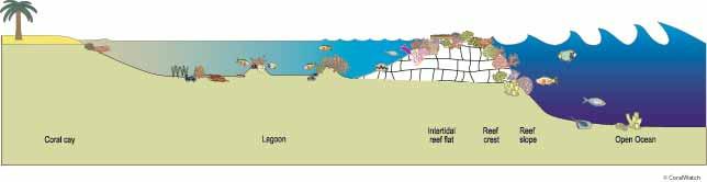


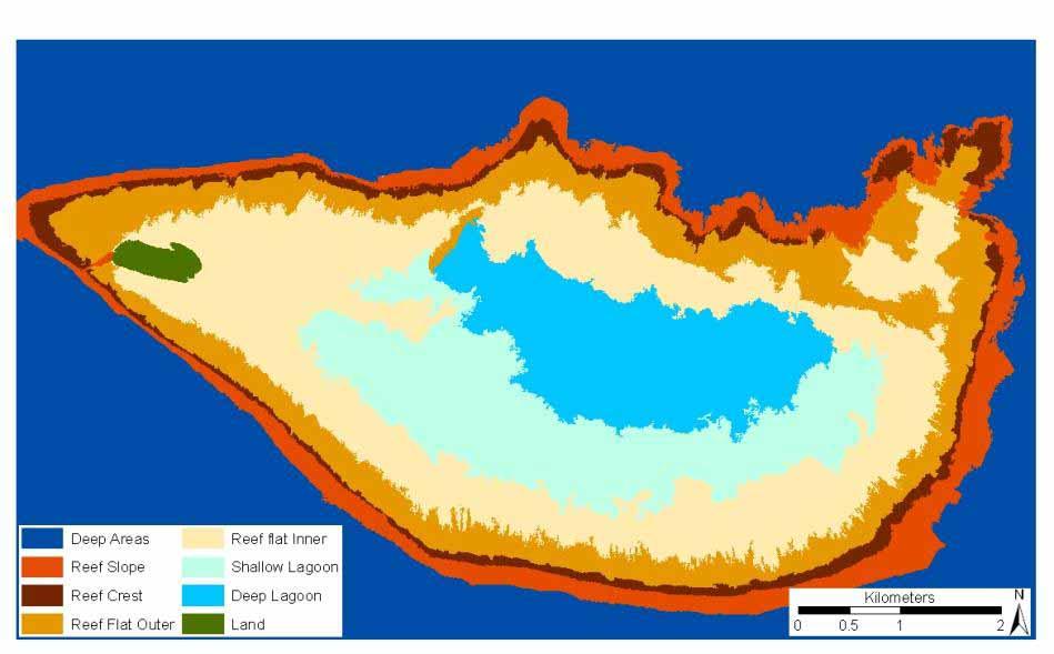
10 Reef Geomorphic Zonation Coral Cay Lagoon Flat Crest Slope


11 Coral Reef System environments vary in specific spatial and information scales Reef Type km 2 km km m m Geomorphic Zone Benthic Community Biotope / Patch

12 Values (Biodiversity, Cultural, Economic)


13 Coral Reefs Environments have Important Ecological, Economical and Cultural values, but are threatened by human and or natural impacts. Values Coastal protection Nursery ground Biodiversity Fishing resources Recreation Carbon Threats Coastal development Run-off and Pollution Over-fishing Boating Bleaching Sea-level rise Cyclones

14 Healthy reefs need the right balance of sunlight, temperature, & water quality Managing and conserving our Coral Reefs requires scientist and managers to have information characterising these reefs in time and space.

15 Monitoring (in water and from the sky)

16 Reef Walking


17 Snorkelling or Diving Surveys Invertebrate Fish Coral, Algae Rubble, Rock Impacts Structure Chemicals Processes

18 Automated Underwater Vehicle Surveys Benthic Light Temperature


19 Sensor Characteristics Satellites capture imagery at different times, some every morning, or every 16 days, others only when its required
20 Remote Sensing Remotely monitoring the earth surface without direct contact. Passive remote sensing, capturing reflection of light on sensitive plate (Satellite image) you taking a photo of the boat Active remote sensing, sending a signal and translating the returned signal in to information (echo sounder) you are driving to fast you need to pay a fine

21 Remote sensing application to coral reefs and surrounding environments has become increasingly critical in monitoring environmental stresses to coral reefs and detecting changes in their environmental conditions.


 2. Early scientific")

22 Historical Research and Mapping of Coral Reefs 1. Mapping the ocean boundaries and coral reefs. (e.g. The Polynesians, Magellan, etc, ) 2. Early scientific investigations describing the coral Reefs (e.g. Cook, Darwin, etc, ) taking 3-5 years for their journeys


23 Remote Sensing of Earth Surface 1859 First Aerial Photo 1960 First Satellite observe clouds + temps 1972 Satellite Designed to look at earth surface Archive satellite imagery since 1978, each image took less then seconds to take
24 Google Earth combines remote sensing imagery with spatial data.(border of barrier reef)

25 Field Data versus Remote Sensing Data Only relative view square meters are assessed, but accurate Every square meter (pixel) that makes up an image is assessed, but relatively not as accurate However both will provide important information to help conserve the magnificent coral reefs


26 Different habitat map extent, scales & categories can be provided by object based image analysis


27 Sensor Characteristics Satellites capture imagery at different times, some every morning, or every 16 days, others only when its required
 Reflected sunlight is scattered, absorbed, transmitted and reflected.")
28 Fundamentals of Remote Sensing Each satellite image is made of millions of pixels Each image pixel contains a measure of reflected sunlight at specific sensitive layers bands (e.g. Blue, Green, Red, Near Infra Red) Reflected sunlight is scattered, absorbed, transmitted and reflected. Same as the photos you take
29 Cheese Cake and Remote Sensing Image(photo) Cheese Cake 1. is made of different layers 2. Each layer has another taste (e.g. strawberry, vanilla, cookies, whip cream, grape) 3. When taking a bite, it gives you the exquisite taste of something really nice Remote Sensing Image (Photo) 1. Is made of different layers 2. Each layer is sensitive for a specific light field (e.g. blue, green, red, etc etc 3. When combining the layers one can see the beautiful colours of the reef

30 Image Pre-Processing Preparing the cooking of Cheese cake 1. Buying the ingredients 2. Unpacking ingredients 3. Each ingredient has different preparation and role Pre-processing an Image 1. Taking the photo 2. Formatting the photo 3. Removing effects from the atmosphere and water Good pre-processing will lead to better taste. or information


31 ctral : Reflectance Spectral Signatures Collection Every feature on earth reflects light and has its own light reflectance signature One pixel on the ground Amount of light reflected Sediment Coral1 Coral2 Algae Blue, Green, Red, Light sensitive layer


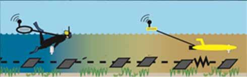
32 Making the Cake Or Map Preparing the cooking of Cheese cake 1. The pre-processed ingredients will be mixed 2. The taste is tested in the process 3. Each gradient will be placed in a specific combination forming taste full combination Pre-processing an Image 1. Place layers on top in one image 2. Pixels are checked with field data 3. Group of pixels with same colour and texture are assigned a mapping category (e.g. coral, land)


33 To Map the Reef You need to understand what happens with Sunlight transmitted, scattered, absorbed and reflected in atmosphere, water column and bottom.

34 Light Path Changes from Air to Water (Features Look Bigger Underwater)


35 Marine Remote Sensing: Effects of water type 5 m Depth 5 m Depth Color Changes At Depth and Water Type (Features Look Less Color Full)


36 Light penetration is limited to water depth, red will be absorbed first and then blue (Divers and snorkelers, know it) Light Penetrates The Water Blue light Blue, Green, Red, NIR Light sensitive layer Red light


37 Water Depth Change The Color Of Sand When Looking From Above Water


38 Spatial scales: Spectral scales: Temporal scales: Mapping Process: Choice of Image Type Pixel size - area covered Number of light sensitive bands and location Acquisition frequency and revisit time e.g. On request Min. every 5 days 2 m pixel Blue, Red, Green e.g. twice daily 25 m pixel Light Blue, Blue, Dark Blue, Light green, Green, etc, etc
39 Field Monitoring Field monitoring is required to help make a map or to check the map Remember: When you make cheese cake you need to do some tasting of the ingredients to be sure its good.


40 Mapping Process - Field Data: Benthic & Substrate Surveys or knowledge used to describe what is on the bottom. Detailed survey Basic survey Local knowledge Expert knowledge


41 Every dot is an photo on the reef GPS towed by diver


42 Photos of the bottom, are assessed on cover of: Coral Algae, Seagrass, Sand, Rubble, Rock 200 m Yellow dots are photos


43 Benthic & Substrate Field Data Georeferenced Photo Transects 200 m Benthic Data Photo Analysis - benthic class - rugosity Photos+data: - Calibrate - Validate


44 Snorkeler vs Robot Depth 44


45 Spectral reflectance library collection to access bottom types can be differentiated with ideal optical remote sensor. Spectral Library Collection Cyano Bacteria Cyano Bacteria Spectral Reflectance Signature Digital camera for photo bottom type
 5. Air water interface (Refraction) 6. Water column (water depth, chlorophyll, sediments) 7. Masking (e.g. land, clouds)")
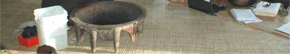
46 Mapping Process Image Pre-Processing Pre-processing correction steps: 1. Radiometric 2. Atmospheric 3. Georeferencing 4. Water surface (sun glint) 5. Air water interface (Refraction) 6. Water column (water depth, chlorophyll, sediments) 7. Masking (e.g. land, clouds)


47 Simple Map: Drawing Lines Over Satellite Image

48 Simple Map: Drawing Lines Over Satellite Image

49 Simple Map: Digitising Lines and Adding a Class

50 What can you see on a map, You can find in the legend.


51 Assign category to each pixel based on colour Assign class to pixels that look the same Each group of pixels with a colour have a signature Field Data Satellite Image 100 m Check if there are any other pixels with the same signature Accuracy assessment

52 Google Earth combines remote sensing imagery with spatial data


53 Capricorn Bunker Group, Great Barrier Reef, Australia Tryon Northwest Heron Sykes Wistari One Tree Polmaise Masthead 0 10km Lamont Fitzroy


54 Coral Reefs Types Platform (Heron Reef) Photo Source: Prof. Justin Marshall


55 Island (500 m x 800 m) 50% National park 25% Resort (200 guest staff) 25% Research Station (100 research/students + 10 staff)

56 Mitchell Australia PhD Student Seagrass Boat support Heron Island Research Station, UQ Douglas Volunteer Diver Javier Peru Postdoc Sea Level Rise Rodney Cuban PhD student Diver


57 Labortory Class Rooms Explaining in the field Exploring Underwater


58 Experiments Facilities Boating Support Diving Support Boats launched from the beach


59 Turtles come a shore to lay eggs Coral Cay and Reef birds living on the island Healthy coral cover, one 2800 Great Barrier Ree Monitoring coral reefs: Above Water

60

61 Monitoring coral reefs: Underwater
62 Satellite Image + photos taken underwater Map Turning Every Pixel into a Class

63 Making a Geomorphic Map of The Reef


64 Making a Benthic Map of The Reef


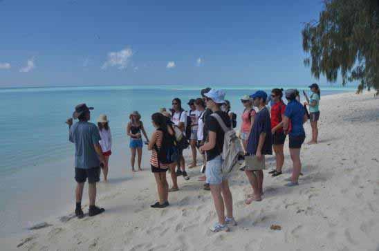
65 2001 June 2006 August 2011 May 2002 May 2007 July 2011 Nov 2004 May 2005 May 2008 Oct 2009 Dec Not only once, but many times for when there is field and image data

66 Heron Palau Fiji and what about large reefs (>300 km 2 )?? Other reefs vary in: Reef composition (e.g. coral, seagrass, algae) Water depth
")
67 Large Reef - (>300 km 2 )

68 Detecting Coral Bleaching In The Field Out in the field, simply compare the brightness of the coral colours with the brightness of the colours on the chart and record matching codes.


 to predict bleaching hot")

69 Predicting Coral Bleaching from Space Sea surface Wind Light Availability Sea Surface Temperature To monitor and manage coral bleaching events a variety of remote sensing data is used (temperature, light availability, wind) to predict bleaching hot spots. Hotspot for Coral Bleaching
 = R(490nm) R(555nm) Output = 0.5 5 = 0.")
70 Determining Where Sea Surface Plankton is, Food for Mantas, Whales and Many Fish Species 1km Original Seawifs Image Each pixel contains : 1: 412nm 2: 443nm 3: 490nm 4: 510nm 5: 555nm 6: 670nm 7: 765nm 8: 865nm 100 EMPIRICAL APPROACH Chlorophyll a concentration Chl a (mg/m 3 ) = R(490nm) R(555nm) Output = = mg/m 3 Estimated absorption (%) Action spectrum of photosynthesis Chlorophyll b Carotenoids Chlorophyll a Wavelength (nm) After Raven et al. (1999:131) Rate of photosynthesis (as % of rate at 670nm)


71 2.4 Temporal Source: Seawifs 7
72 Workshop Google Earth Data files (kml) Reef monitoring sites Reef temperature Reef Impacts Find reef types?

73 Acknowledgements and Contacts Staff and Students University of Queensland Various Research Grants Research Stations in Heron, Moreton Bay, Fiji, Palau People of Fiji, Palau, Cook Island, Solomon's, Indonesia, Belize Chris Roelfsema
74 Workshop Start computer Login Start internet explorer and login with same login to get access to internet Close internet explorer Start Google Earth
75 Explore Reefs First go to GBR and see reef types Pick a reef and zoom in and see the detail present See differences in colour and water depth
76 Add Information in google earth Kml or kmz files spatial data located in s: /Student/courses/Geographyday Open GBR reef kml, and find the name of a reef and its extent Open Reef Temp find reef areas with high temperature Open reef monitoring site find reefs where monitoring take place

77
Coral Reef Remote Sensing
 Coral Reef Remote Sensing Spectral, Spatial, Temporal Scaling Phillip Dustan Sensor Spatial Resolutio n Number of Bands Useful Bands coverage cycle Operation Landsat 80m 2 2 18 1972-97 Thematic 30m 7
MULTI-TEMPORAL SATELLITE IMAGES WITH BATHYMETRY CORRECTION FOR MAPPING AND ASSESSING SEAGRASS BED CHANGES IN DONGSHA ATOLL
 MULTI-TEMPORAL SATELLITE IMAGES WITH BATHYMETRY CORRECTION FOR MAPPING AND ASSESSING SEAGRASS BED CHANGES IN DONGSHA ATOLL Chih -Yuan Lin and Hsuan Ren Center for Space and Remote Sensing Research, National
IDENTIFICATION AND MAPPING OF HAWAIIAN CORAL REEFS USING HYPERSPECTRAL REMOTE SENSING
 IDENTIFICATION AND MAPPING OF HAWAIIAN CORAL REEFS USING HYPERSPECTRAL REMOTE SENSING Jessica Frances N. Ayau College of Education University of Hawai i at Mānoa Honolulu, HI 96822 ABSTRACT Coral reefs
Shallow Water Remote Sensing
 Shallow Water Remote Sensing John Hedley, IOCCG Summer Class 2018 Overview - different methods and applications Physics-based model inversion methods High spatial resolution imagery and Sentinel-2 Bottom
Application of Soft Classification Algorithm In Increasing Per Class Classification Accuracy Of Coral Habitat. Aidy M Muslim
 Application of Soft Classification Algorithm In Increasing Per Class Classification Accuracy Of Coral Habitat Aidy M Muslim INTRODUCTION Coral reefs play an essential role to our ecosystem and offer the
Module 3 Introduction to GIS. Lecture 8 GIS data acquisition
 Module 3 Introduction to GIS Lecture 8 GIS data acquisition GIS workflow Data acquisition (geospatial data input) GPS Remote sensing (satellites, UAV s) LiDAR Digitized maps Attribute Data Management Data
Lecture 2. Electromagnetic radiation principles. Units, image resolutions.
 NRMT 2270, Photogrammetry/Remote Sensing Lecture 2 Electromagnetic radiation principles. Units, image resolutions. Tomislav Sapic GIS Technologist Faculty of Natural Resources Management Lakehead University
How to Access Imagery and Carry Out Remote Sensing Analysis Using Landsat Data in a Browser
 How to Access Imagery and Carry Out Remote Sensing Analysis Using Landsat Data in a Browser Including Introduction to Remote Sensing Concepts Based on: igett Remote Sensing Concept Modules and GeoTech
On the use of water color missions for lakes in 2021
 Lakes and Climate: The Role of Remote Sensing June 01-02, 2017 On the use of water color missions for lakes in 2021 Cédric G. Fichot Department of Earth and Environment 1 Overview 1. Past and still-ongoing
Towards a Management Plan for a Tropical Reef-Lagoon System Using Airborne Multispectral Imaging and GIS
 Towards a Management Plan for a Tropical Reef-Lagoon System Using Airborne Multispectral Imaging and GIS This paper was presented at the Fourth International Conference on Remote Sensing for Marine and
Remote Sensing. in Agriculture. Dr. Baqer Ramadhan CRP 514 Geographic Information System. Adel M. Al-Rebh G Term Paper.
 Remote Sensing in Agriculture Term Paper to Dr. Baqer Ramadhan CRP 514 Geographic Information System By Adel M. Al-Rebh G199325390 May 2012 Table of Contents 1.0 Introduction... 4 2.0 Objective... 4 3.0
Outline for today. Geography 411/611 Remote sensing: Principles and Applications. Remote sensing: RS for biogeochemical cycles
 Geography 411/611 Remote sensing: Principles and Applications Thomas Albright, Associate Professor Laboratory for Conservation Biogeography, Department of Geography & Program in Ecology, Evolution, & Conservation
Chapter 8. Remote sensing
 1. Remote sensing 8.1 Introduction 8.2 Remote sensing 8.3 Resolution 8.4 Landsat 8.5 Geostationary satellites GOES 8.1 Introduction What is remote sensing? One can describe remote sensing in different
Interpreting land surface features. SWAC module 3
 Interpreting land surface features SWAC module 3 Interpreting land surface features SWAC module 3 Different kinds of image Panchromatic image True-color image False-color image EMR : NASA Echo the bat
Multiplatform Remote Sensing for Coral Reef Community Assessment
 Multiplatform Remote Sensing for Coral Reef Community Assessment Quinta Reunión Nacional de Percepción Remota y Sistemas de Información Geográfica en Puerto Rico September 27, 2007 Roy A. Armstrong, Ph.
MERIS instrument. Muriel Simon, Serco c/o ESA
 MERIS instrument Muriel Simon, Serco c/o ESA Workshop on Sustainable Development in Mountain Areas of Andean Countries Mendoza, Argentina, 26-30 November 2007 ENVISAT MISSION 2 Mission Chlorophyll case
Figure 3: Map showing the extension of the six surveyed areas in Indonesia analysed in this study.
 5 2. METHODOLOGY The present study consisted of two phases. First a test study was conducted to evaluate whether Landsat 7 images could be used to identify the habitat of humphead wrasse in Indonesia.
FOR 353: Air Photo Interpretation and Photogrammetry. Lecture 2. Electromagnetic Energy/Camera and Film characteristics
 FOR 353: Air Photo Interpretation and Photogrammetry Lecture 2 Electromagnetic Energy/Camera and Film characteristics Lecture Outline Electromagnetic Radiation Theory Digital vs. Analog (i.e. film ) Systems
NON-PHOTOGRAPHIC SYSTEMS: Multispectral Scanners Medium and coarse resolution sensor comparisons: Landsat, SPOT, AVHRR and MODIS
 NON-PHOTOGRAPHIC SYSTEMS: Multispectral Scanners Medium and coarse resolution sensor comparisons: Landsat, SPOT, AVHRR and MODIS CLASSIFICATION OF NONPHOTOGRAPHIC REMOTE SENSORS PASSIVE ACTIVE DIGITAL
Introduction. Introduction. Introduction. Introduction. Introduction
 Identifying habitat change and conservation threats with satellite imagery Extinction crisis Volker Radeloff Department of Forest Ecology and Management Extinction crisis Extinction crisis Conservationists
Application of Remote Sensing in the Monitoring of Marine pollution. By Atif Shahzad Institute of Environmental Studies University of Karachi
 Application of Remote Sensing in the Monitoring of Marine pollution By Atif Shahzad Institute of Environmental Studies University of Karachi Remote Sensing "Remote sensing is the science (and to some extent,
Light penetration within a clear water body. E z = E 0 e -kz
 THE BLUE PLANET 1 2 Light penetration within a clear water body E z = E 0 e -kz 3 4 5 Pure Seawater Phytoplankton b w 10-2 m -1 b w 10-2 m -1 b w, Morel (1974) a w, Pope and Fry (1997) b chl,loisel and
Introduction to Remote Sensing
 Introduction to Remote Sensing Spatial, spectral, temporal resolutions Image display alternatives Vegetation Indices Image classifications Image change detections Accuracy assessment Satellites & Air-Photos
The Study of Sea Bottom Morphology and Bathymetric Mapping Using Worldview-2 Imagery
 The Study of Sea Bottom Morphology and Bathymetric Mapping Using Worldview-2 Imagery Iwan E. Setiawan Badan Informasi Geospasial, Cibinong, Indonesia Doddy M. Yuwono Badan Informasi Geospasial, Cibinong,
SATELLITE OCEANOGRAPHY
 SATELLITE OCEANOGRAPHY An Introduction for Oceanographers and Remote-sensing Scientists I. S. Robinson Lecturer in Physical Oceanography Department of Oceanography University of Southampton JOHN WILEY
Fugro Worldwide Fugro Environmental
 1 2 Fugro Worldwide The Fugro group of companies is an international consulting company that provides measurements and interpretations of data related to the earth's surface and the soils and rocks beneath.
NOTES ON A SHORT TRIP TO MALDIVES MARCH 29TH TO APRIL 1ST 2018.
 NOTES ON A SHORT TRIP TO MALDIVES MARCH 29TH TO APRIL 1ST 2018. Author: Jonathan Taylor. Contact: jonathan.taylor@rspb.rg.uk Based at the southern most point of the Maldives and indeed Asia - Addu Atol
CoralWatch Reef Monitoring Program. Lady Elliot Island - Great Barrier Reef - Australia
 CoralWatch Reef Monitoring Program Lady Elliot Island - Great Barrier Reef - Australia Coral Bleaching Coral bleaching occurs when corals change colour, generally from dark brown to a lighter shade of
remote sensing? What are the remote sensing principles behind these Definition
 Introduction to remote sensing: Content (1/2) Definition: photogrammetry and remote sensing (PRS) Radiation sources: solar radiation (passive optical RS) earth emission (passive microwave or thermal infrared
REMOTE SENSING. Topic 10 Fundamentals of Digital Multispectral Remote Sensing MULTISPECTRAL SCANNERS MULTISPECTRAL SCANNERS
 REMOTE SENSING Topic 10 Fundamentals of Digital Multispectral Remote Sensing Chapter 5: Lillesand and Keifer Chapter 6: Avery and Berlin MULTISPECTRAL SCANNERS Record EMR in a number of discrete portions
Present and future of marine production in Boka Kotorska
 Present and future of marine production in Boka Kotorska First results from satellite remote sensing for the breeding areas of filter feeders in the Bay of Kotor INTRODUCTION Environmental monitoring is
Introduction to Remote Sensing
 Introduction to Remote Sensing Daniel McInerney Urban Institute Ireland, University College Dublin, Richview Campus, Clonskeagh Drive, Dublin 14. 16th June 2009 Presentation Outline 1 2 Spaceborne Sensors
Roberts Bank Terminal 2 Project Field Studies Information Sheet
 July 2012 Port Metro Vancouver is continuing field studies in July as part of ongoing environmental and technical work for the proposed Roberts Bank Terminal 2 Project. Roberts Bank Terminal 2 Project
Paluma Environmental Education Centre
 Paluma Environmental Education Centre Science (Biology) Field Workbook for Picnic Bay Year 4 Unit 2 Mapping the life cycle and survival of the Bush stone-curlew My Name: My Class: My working group: My
CATLIN SEAVIEW SURVEY PUBLISHES GAME- CHANGING VISUAL RECORD OF GREAT BARRIER REEF
 PRESS RELEASE For immediate release CATLIN SEAVIEW SURVEY PUBLISHES GAME- CHANGING VISUAL RECORD OF GREAT BARRIER REEF IMAGES ALSO RELEASED IN STREET VIEW IN GOOGLE MAPS More than 100,000 images spanning
Airborne Hyperspectral Remote Sensing
 Airborne Hyperspectral Remote Sensing Curtiss O. Davis Code 7212 Naval Research Laboratory 4555 Overlook Ave. S.W. Washington, D.C. 20375 phone (202) 767-9296 fax (202) 404-8894 email: davis@rsd.nrl.navy.mil
IKONOS High Resolution Multispectral Scanner Sensor Characteristics
 High Spatial Resolution and Hyperspectral Scanners IKONOS High Resolution Multispectral Scanner Sensor Characteristics Launch Date View Angle Orbit 24 September 1999 Vandenberg Air Force Base, California,
The studies began when the Tiros satellites (1960) provided man s first synoptic view of the Earth s weather systems.
 provided man s first synoptic view of the Earth s weather systems.") Remote sensing of the Earth from orbital altitudes was recognized in the mid-1960 s as a potential technique for obtaining information important for the effective use and conservation of natural resources.
Remote sensing of the Earth from orbital altitudes was recognized in the mid-1960 s as a potential technique for obtaining information important for the effective use and conservation of natural resources.
ESTIMATING REEF HABITAT COVERAGE SUITABLE FOR THE HUMPHEAD WRASSE, CHEILINUS UNDULATUS, USING REMOTE SENSING
 FAO Fisheries and Aquaculture Circular No. 1057 FIRF/C1057 (En) ISSN 2070-6065 ESTIMATING REEF HABITAT COVERAGE SUITABLE FOR THE HUMPHEAD WRASSE, CHEILINUS UNDULATUS, USING REMOTE SENSING Copies of FAO
Viewing New Hampshire from Space
 Viewing New Hampshire from Space A Bird s-eye View of the Granite State! Introduction Environmental changes are a major concern for researchers and policy makers today since these changes have both human
Ground Truth for Calibrating Optical Imagery to Reflectance
 Visual Information Solutions Ground Truth for Calibrating Optical Imagery to Reflectance The by: Thomas Harris Whitepaper Introduction: Atmospheric Effects on Optical Imagery Remote sensing of the Earth
Fundamentals of Remote Sensing
 Climate Variability, Hydrology, and Flooding Fundamentals of Remote Sensing May 19-22, 2015 GEO-Latin American & Caribbean Water Cycle Capacity Building Workshop Cartagena, Colombia 1 Objective To provide
PILOTING A DECISION SUPPORT TOOL (DST) FOR MAPPING CYANOBACTERIAL HARMFUL ALGAL BLOOMS (CHABS) TO SUPPORT PUBLIC HEALTH AND RESOURCE MANAGEMENT.
 FOR MAPPING CYANOBACTERIAL HARMFUL ALGAL BLOOMS (CHABS) TO SUPPORT PUBLIC HEALTH AND RESOURCE MANAGEMENT.") PILOTING A DECISION SUPPORT TOOL (DST) FOR MAPPING CYANOBACTERIAL HARMFUL ALGAL BLOOMS (CHABS) TO SUPPORT PUBLIC HEALTH AND RESOURCE MANAGEMENT. Nathan Torbick, Applied Geosolutions Scott Stoodley, Director,
PILOTING A DECISION SUPPORT TOOL (DST) FOR MAPPING CYANOBACTERIAL HARMFUL ALGAL BLOOMS (CHABS) TO SUPPORT PUBLIC HEALTH AND RESOURCE MANAGEMENT. Nathan Torbick, Applied Geosolutions Scott Stoodley, Director,
Final Examination Introduction to Remote Sensing. Time: 1.5 hrs Max. Marks: 50. Section-I (50 x 1 = 50 Marks)
") Final Examination Introduction to Remote Sensing Time: 1.5 hrs Max. Marks: 50 Note: Attempt all questions. Section-I (50 x 1 = 50 Marks) 1... is the technology of acquiring information about the Earth's
Final Examination Introduction to Remote Sensing Time: 1.5 hrs Max. Marks: 50 Note: Attempt all questions. Section-I (50 x 1 = 50 Marks) 1... is the technology of acquiring information about the Earth's
VITO - Remote Sensing and Coastal Zone Management 18/02/ , VITO NV
 VITO - Remote Sensing and Coastal Zone Management 18/02/2016 1 VITO IN NUMBERS» 750 employees» 26 nationalities» More than 400 patents worldwide» HQ in Mol, België. Offices in Ostend, Berchem, Ghent, Genk»
APCAS/10/21 April 2010 ASIA AND PACIFIC COMMISSION ON AGRICULTURAL STATISTICS TWENTY-THIRD SESSION. Siem Reap, Cambodia, April 2010
 APCAS/10/21 April 2010 Agenda Item 8 ASIA AND PACIFIC COMMISSION ON AGRICULTURAL STATISTICS TWENTY-THIRD SESSION Siem Reap, Cambodia, 26-30 April 2010 The Use of Remote Sensing for Area Estimation by Robert
Ozobot Bit. Computer Science Engineering Program
 3 rd Grade Ozobot Bit Computer Science Engineering Program Post Visit Activity Resources 2018 Winter/Spring 2018 Dear Third Grade Visiting Classroom Teacher, It is hoped that you and your students enjoyed
Satellite Remote Sensing: Earth System Observations
 Satellite Remote Sensing: Earth System Observations Land surface Water Atmosphere Climate Ecosystems 1 EOS (Earth Observing System) Develop an understanding of the total Earth system, and the effects of
Lecture 6: Multispectral Earth Resource Satellites. The University at Albany Fall 2018 Geography and Planning
 Lecture 6: Multispectral Earth Resource Satellites The University at Albany Fall 2018 Geography and Planning Outline SPOT program and other moderate resolution systems High resolution satellite systems
MARITIME CITY PENINSULA
 Dubai has always been a city with a strong maritime heritage. The pearl diving industry for hundreds of years before the discovery of oil was the primary source of income for the people and the sea was
Copernicus Introduction Lisbon, Portugal 13 th & 14 th February 2014
 Copernicus Introduction Lisbon, Portugal 13 th & 14 th February 2014 Contents Introduction GMES Copernicus Six thematic areas Infrastructure Space data An introduction to Remote Sensing In-situ data Applications
First Exam: New Date. 7 Geographers Tools: Gathering Information. Photographs and Imagery REMOTE SENSING 2/23/2018. Friday, March 2, 2018.
 First Exam: New Date Friday, March 2, 2018. Combination of multiple choice questions and map interpretation. Bring a #2 pencil with eraser. Based on class lectures supplementing chapter 1. Review lecture
Managing and Monitoring Intertidal Oyster Reefs with Remote Sensing in Coastal South Carolina
 Managing and Monitoring Intertidal Oyster Reefs with Remote Sensing in Coastal South Carolina A cooperative effort between: Coastal Services Center South Carolina Department of Natural Resources City of
Monitoring water pollution in the river Ganga with innovations in airborne remote sensing and drone technology
 Monitoring water pollution in the river Ganga with innovations in airborne remote sensing and drone technology RAJIV SINHA, DIPRO SARKAR DEPARTMENT OF EARTH SCIENCES, INDIAN INSTITUTE OF TECHNOLOGY KANPUR,
1. INTRODUCTION. GOCI : Geostationary Ocean Color Imager
 1. INTRODUCTION The Korea Ocean Research and Development Institute (KORDI) releases an announcement of opportunity (AO) to carry out scientific research for the utilization of GOCI data. GOCI is the world
From Proba-V to Proba-MVA
 From Proba-V to Proba-MVA Fabrizio Niro ESA Sensor Performances Products and Algorithm (SPPA) ESA UNCLASSIFIED - For Official Use Proba-V extension in the Copernicus era Proba-V was designed with the main
First Exam: Thurs., Sept 28
 8 Geographers Tools: Gathering Information Prof. Anthony Grande Hunter College Geography Lecture design, content and presentation AFG 0917. Individual images and illustrations may be subject to prior copyright.
2017 REMOTE SENSING EVENT TRAINING STRATEGIES 2016 SCIENCE OLYMPIAD COACHING ACADEMY CENTERVILLE, OH
 2017 REMOTE SENSING EVENT TRAINING STRATEGIES 2016 SCIENCE OLYMPIAD COACHING ACADEMY CENTERVILLE, OH This presentation was prepared using draft rules. There may be some changes in the final copy of the
Geo/SAT 2 INTRODUCTION TO REMOTE SENSING
 Geo/SAT 2 INTRODUCTION TO REMOTE SENSING Paul R. Baumann, Professor Emeritus State University of New York College at Oneonta Oneonta, New York 13820 USA COPYRIGHT 2008 Paul R. Baumann Introduction Remote
Lecture 1 Introduction to Remote Sensing
 Lecture 1 Introduction to Remote Sensing Dr Ian Leiper School of Environmental and Life Sciences Bldg Purple 12.2.27 1 2 Lecture Outline Introductions Unit admin Learning outcomes Unit outline Practicals
earthobservation.wordpress.com
 Dirty REMOTE SENSING earthobservation.wordpress.com Stuart Green Teagasc Stuart.Green@Teagasc.ie 1 Purpose Give you a very basic skill set and software training so you can: find free satellite image data.
Lecture 13: Remotely Sensed Geospatial Data
 Lecture 13: Remotely Sensed Geospatial Data A. The Electromagnetic Spectrum: The electromagnetic spectrum (Figure 1) indicates the different forms of radiation (or simply stated light) emitted by nature.
Benthic Photo Survey Documentation
 Benthic Photo Survey Documentation Release 1.0.1 Jared Kibele December 18, 2014 Contents 1 Contents 3 1.1 Introduction............................................... 3 1.2 Installation................................................
Introduction of Satellite Remote Sensing
 Introduction of Satellite Remote Sensing Spatial Resolution (Pixel size) Spectral Resolution (Bands) Resolutions of Remote Sensing 1. Spatial (what area and how detailed) 2. Spectral (what colors bands)
Marine mammal monitoring
 Marine mammal monitoring Overseas territories REMMOA campaigns : survey of marine mammals and other pelagic megafauna by aerial observation West Indies French Guiana / Indian Ocean / French Polynesia /
High Resolution Multi-spectral Imagery
 High Resolution Multi-spectral Imagery Jim Baily, AirAgronomics AIRAGRONOMICS Having been involved in broadacre agriculture until 2000 I perceived a need for a high resolution remote sensing service to
1. Theory of remote sensing and spectrum
 1. Theory of remote sensing and spectrum 7 August 2014 ONUMA Takumi Outline of Presentation Electromagnetic wave and wavelength Sensor type Spectrum Spatial resolution Spectral resolution Mineral mapping
An Evaluation of the Coastal Ambassadors Course in South Australia. Mike Bossley & Kristy Watson (Adelaide & Mt Lofty NRM)
") An Evaluation of the Coastal Ambassadors Course in South Australia Mike Bossley & Kristy Watson (Adelaide & Mt Lofty NRM) A Coastal Ambassadors program was started by the Pittwater Council s Coastal Environment
An Evaluation of the Coastal Ambassadors Course in South Australia Mike Bossley & Kristy Watson (Adelaide & Mt Lofty NRM) A Coastal Ambassadors program was started by the Pittwater Council s Coastal Environment
An Introduction to Remote Sensing & GIS. Introduction
 An Introduction to Remote Sensing & GIS Introduction Remote sensing is the measurement of object properties on Earth s surface using data acquired from aircraft and satellites. It attempts to measure something
9/12/2011. Training Course Remote Sensing Basic Theory & Image Processing Methods September 2011
 Training Course Remote Sensing Basic Theory & Image Processing Methods 19 23 September 2011 Popular Remote Sensing Sensors & their Selection Michiel Damen (September 2011) damen@itc.nl 1 Overview Low resolution
Jeffrey H. Bowles, Wesley J. Moses, Gia M. Lamela, Richard Mied, Karen W. Patterson, and Ellen J. Wagner
 1 Jeffrey H. Bowles, Wesley J. Moses, Gia M. Lamela, Richard Mied, Karen W. Patterson, and Ellen J. Wagner and, Washington, D.C. from Center for Advanced Land Management Information Technologies (CALMIT),
First Exam. Geographers Tools: Gathering Information. Photographs and Imagery. SPIN 2 Image of Downtown Atlanta, GA 1995 REMOTE SENSING 9/19/2016
 First Exam Geographers Tools: Gathering Information Prof. Anthony Grande Hunter College Geography Lecture design, content and presentation AFG 0616. Individual images and illustrations may be subject to
Earth Exploration-Satellite Service (EESS) - Passive Spaceborne Remote Sensing
 - Passive Spaceborne Remote Sensing") Earth Exploration-Satellite Service (EESS) - Passive Spaceborne Remote Sensing John Zuzek Vice-Chairman ITU-R Study Group 7 ITU/WMO Seminar on Spectrum & Meteorology Geneva, Switzerland 16-17 September
Earth Exploration-Satellite Service (EESS) - Passive Spaceborne Remote Sensing John Zuzek Vice-Chairman ITU-R Study Group 7 ITU/WMO Seminar on Spectrum & Meteorology Geneva, Switzerland 16-17 September
Study of Chlorophyll-a Distribution of Microalgae at Tasik Aman and Tasik Harapan in Penang Island Malaysia using Landsat Image
 ISSN 2407-289 Study of Chlorophyll-a Distribution of Microalgae at Tasik Aman and Tasik Harapan in Penang Island Malaysia using Landsat Image a b c Fairooz Johan, Mohd Zubir Mat Jafri, Lim Hwee San,Wan
Image interpretation. Aliens create Indian Head with an ipod? Badlands Guardian (CBC) This feature can be found 300 KMs SE of Calgary.
 This feature can be found 300 KMs SE of Calgary.") Image interpretation Aliens create Indian Head with an ipod? Badlands Guardian (CBC) This feature can be found 300 KMs SE of Calgary. 50 1 N 110 7 W Milestones in the History of Remote Sensing 19 th century
Image interpretation Aliens create Indian Head with an ipod? Badlands Guardian (CBC) This feature can be found 300 KMs SE of Calgary. 50 1 N 110 7 W Milestones in the History of Remote Sensing 19 th century
Remote Sensing and GIS
 Remote Sensing and GIS Atmosphere Reflected radiation, e.g. Visible Emitted radiation, e.g. Infrared Backscattered radiation, e.g. Radar (λ) Visible TIR Radar & Microwave 11/9/2017 Geo327G/386G, U Texas,
MAPPING SEAGRASS LEAF AREA INDEX, STANDING CROP, AND ABOVE GROUND CARBON STOCK USING COMPRESSED REMOTE SENSING DATA
 PAPER ID F5 MAPPING SEAGRASS LEAF AREA INDEX, STANDING CROP, AND ABOVE GROUND CARBON STOCK USING COMPRESSED REMOTE SENSING DATA Pramaditya Wicaksono Cartography and Remote Sensing, Faculty of Geography,
Aim of Lesson. Objectives. Background Information
 Lesson 8: Mapping major inshore marine habitats 8: MAPPING THE MAJOR INSHORE MARINE HABITATS OF THE CAICOS BANK BY MULTISPECTRAL CLASSIFICATION USING LANDSAT TM Aim of Lesson To learn how to undertake
An Introduction to Geomatics. Prepared by: Dr. Maher A. El-Hallaq خاص بطلبة مساق مقدمة في علم. Associate Professor of Surveying IUG
 An Introduction to Geomatics خاص بطلبة مساق مقدمة في علم الجيوماتكس Prepared by: Dr. Maher A. El-Hallaq Associate Professor of Surveying IUG 1 Airborne Imagery Dr. Maher A. El-Hallaq Associate Professor
Pléiades imagery for coastal and inland water applications
 Pléiades imagery for coastal and inland water applications Pléiades 2014-09-08 Quinten Vanhellemont & PONDER project 2017-10-20 dredging ship PONDER SR/00/325 «Ocean colour remote sensing» Remote sensing
Monitoring the vegetation success of a rehabilitated mine site using multispectral UAV imagery. Tim Whiteside & Renée Bartolo, eriss
 Monitoring the vegetation success of a rehabilitated mine site using multispectral UAV imagery Tim Whiteside & Renée Bartolo, eriss About the Supervising Scientist Main roles Working to protect the environment
Passive Microwave Sensors LIDAR Remote Sensing Laser Altimetry. 28 April 2003
 Passive Microwave Sensors LIDAR Remote Sensing Laser Altimetry 28 April 2003 Outline Passive Microwave Radiometry Rayleigh-Jeans approximation Brightness temperature Emissivity and dielectric constant
REMOTE SENSING FOR FLOOD HAZARD STUDIES.
 REMOTE SENSING FOR FLOOD HAZARD STUDIES. OPTICAL SENSORS. 1 DRS. NANETTE C. KINGMA 1 Optical Remote Sensing for flood hazard studies. 2 2 Floods & use of remote sensing. Floods often leaves its imprint
Satellite Imagery and Remote Sensing. DeeDee Whitaker SW Guilford High EES & Chemistry
 Satellite Imagery and Remote Sensing DeeDee Whitaker SW Guilford High EES & Chemistry whitakd@gcsnc.com Outline What is remote sensing? How does remote sensing work? What role does the electromagnetic
Remote sensing in archaeology from optical to lidar. Krištof Oštir ModeLTER Scientific Research Centre of the Slovenian Academy of Sciences and Arts
 Remote sensing in archaeology from optical to lidar Krištof Oštir ModeLTER Scientific Research Centre of the Slovenian Academy of Sciences and Arts Introduction Optical remote sensing Systems Search for
GOCI Status and Cooperation with CoastColour Project
 GOCI Status and Cooperation with CoastColour Project Joo-Hyung RYU Contribution from : KOSC colleaques Nov. 17, 2010 World 1 st GOCI/COMS Launch Campaign Launch Date : June 27 2010 Launch Vehicle : Ariane-V
Sommersemester Prof. Dr. Christoph Kleinn Institut für Waldinventur und Waldwachstum Arbeitsbereich Fernerkundung und Waldinventur.
 Basics of Remote Sensing Some literature references Franklin, SE 2001 Remote Sensing for Sustainable Forest Management Lewis Publishers 407p Lillesand, Kiefer 2000 Remote Sensing and Image Interpretation
9/12/2011. Training Course Remote Sensing Basic Theory & Image Processing Methods September 2011
 Training Course Remote Sensing Basic Theory & Image Processing Methods 19 23 September 2011 Remote Sensing Platforms Michiel Damen (September 2011) damen@itc.nl 1 Overview Platforms & missions aerial surveys
Status of the Coral Reef of Swains Island 1998
 Status of the Coral Reef of Swains Island 1998 Mike Page and Alison Green Department of Marine and Wildlife Resources Government of American Samoa P.O. Box 3730 American Samoa 96799 Swains Island - showing
Preparing Remote Sensing Data for Natural Resources Mapping (image enhancement, rectifications )
") Preparing Remote Sensing Data for Natural Resources Mapping (image enhancement, rectifications ) Why is this important What are the major approaches Examples of digital image enhancement Follow up exercises
Preparing Remote Sensing Data for Natural Resources Mapping (image enhancement, rectifications ) Why is this important What are the major approaches Examples of digital image enhancement Follow up exercises
Page 1. Abstract: History
 GIS in the Virgin Islands National Park & the Coral Reef National Monument Christy Loomis Virgin Islands National Park ESRI Federal User Conference January 31- February 2, 2006 Abstract: The Virgin Islands
Uses of Electromagnetic Waves
 Uses of Electromagnetic Waves 1 of 42 Boardworks Ltd 2016 Uses of Electromagnetic Waves 2 of 42 Boardworks Ltd 2016 What are radio waves? 3 of 42 Boardworks Ltd 2016 The broadcast of every radio and television
SEA GRASS MAPPING FROM SATELLITE DATA
 JSPS National Coordinators Meeting, Coastal Marine Science 19 20 May 2008 Melaka SEA GRASS MAPPING FROM SATELLITE DATA Mohd Ibrahim Seeni Mohd, Nurul Hazrina Idris, Samsudin Ahmad 1. Introduction PRESENTATION
Remote Sensing Part 3 Examples & Applications
 Remote Sensing Part 3 Examples & Applications Review: Spectral Signatures Review: Spectral Resolution Review: Computer Display of Remote Sensing Images Individual bands of satellite data are mapped to
Upon arrival at Baltra you will be met by the crew from the Angelito and your Galapagos experience will begin.
 Angelito 4 Days Loving run by a local Galapagos family, Angelito I is an excellent option within her price category. Tourist superior, but first class service. Very charming, and whilst not the sleekest
Introduction to Remote Sensing Fundamentals of Satellite Remote Sensing. Mads Olander Rasmussen
 Introduction to Remote Sensing Fundamentals of Satellite Remote Sensing Mads Olander Rasmussen (mora@dhi-gras.com) 01. Introduction to Remote Sensing DHI What is remote sensing? the art, science, and technology
Exploring National Marine Sanctuaries
 Each student team researches and reports on one of the National Marine Sanctuaries and completes a thought-provoking worksheet to compare and contrast their sanctuary with the others. SUBJECTS Science,
Making NDVI Images using the Sony F717 Nightshot Digital Camera and IR Filters and Software Created for Interpreting Digital Images.
 Making NDVI Images using the Sony F717 Nightshot Digital Camera and IR Filters and Software Created for Interpreting Digital Images Draft 1 John Pickle Museum of Science October 14, 2004 Digital Cameras
Unmanned Aerial Vehicles: A New Approach for Coastal Habitat Assessment
 Unmanned Aerial Vehicles: A New Approach for Coastal Habitat Assessment David Ryan Principal Marine Scientist WorleyParsons Western Operations 2 OUTLINE Importance of benthic habitat assessment. Common
Land Cover Analysis to Determine Areas of Clear-cut and Forest Cover in Olney, Montana. Geob 373 Remote Sensing. Dr Andreas Varhola, Kathry De Rego
 1 Land Cover Analysis to Determine Areas of Clear-cut and Forest Cover in Olney, Montana Geob 373 Remote Sensing Dr Andreas Varhola, Kathry De Rego Zhu an Lim (14292149) L2B 17 Apr 2016 2 Abstract Montana