Unmanned Aerial Vehicles: A New Approach for Coastal Habitat Assessment
|
|
|
- Emerald Harrington
- 6 years ago
- Views:
Transcription


1 Unmanned Aerial Vehicles: A New Approach for Coastal Habitat Assessment David Ryan Principal Marine Scientist WorleyParsons Western Operations
2 2 OUTLINE Importance of benthic habitat assessment. Common techniques for aerial mapping Advent of Unmanned Aerial Vehicles for high resolution work UAV classes, applications and sensor types Case study: Port Hedland, WA Limitations WP Future directions


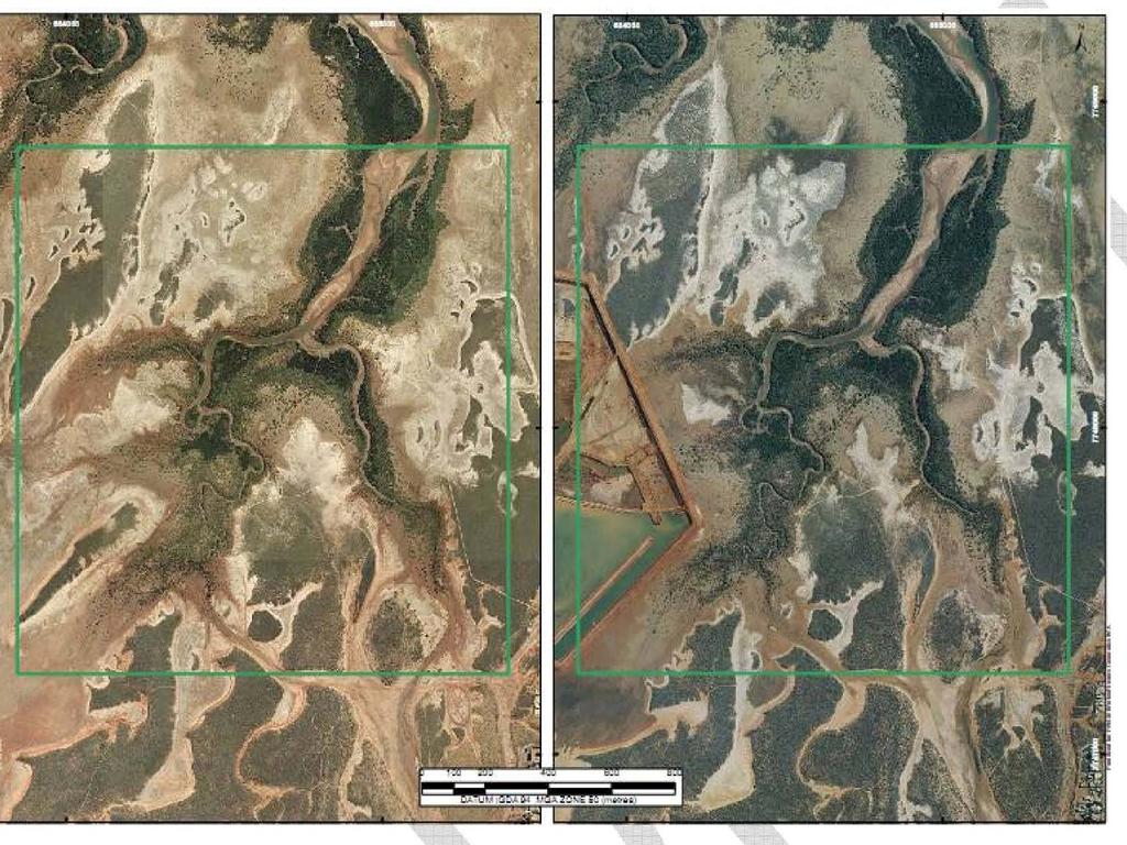
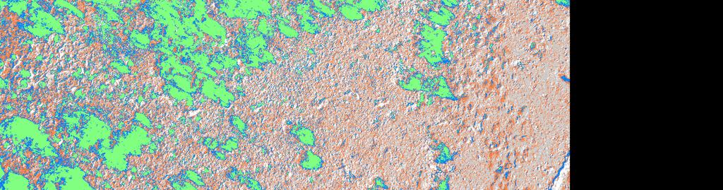
3 3 BENTHIC HABITAT MAPPING Critical-path for EIA under the EPAs Guidance Statement EAG3. Focus on coastal and intertidal areas (e.g. mangroves, seagrasses, saltmarshes). Optical and hyperspectral mapping now routine. Key issues include cost of data capture and mapping at scales appropriate to the biota.
4 4 Commonly Used Habitat Mapping Techniques Sensor/ Platform Worldview-2, GeoEye1 Frequency Resolution Relative Cost Sub-weekly m, multispectral 10K+ per scene Quickbird Weekly m 5K+ per scene Aerial Survey e.g. HyMap, Hyspex, LADS, Shoals Sonar Survey Low, based on aircraft mobs. Low, based on vessel mobs. Depends on survey characteristics 100K+ per survey. HSE Risk! m 50K+ per survey Ground work Based on field staff mobs. Very high Varies; HSE Risk!


5 5 UNMANNED AERIAL VEHICLES (UAVs) First developed for military applications (e.g. Predator, Reaper). Advanced motion and positioning sensors. Compact computing power. Commercial applications: Police, SAR, crop assessments, news footage, real estate, coast watch etc.

6 6 Class Advantages Disadvantages Applications Vertical Take Off & Landing (VTOL)/Rotor Fixed wing Hover and vertical take-off; maneuverability. Larger payloads; longer ranges. Difficult to pilot, complex guidance software. Low maneuverability. Blimp Low cost. Susceptible to high wind speeds; slow. Targeted sampling. Systematic aerial photography. Limited aerial photography.
.")
.")
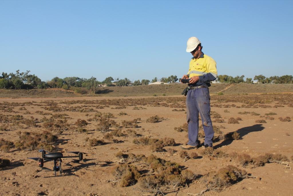
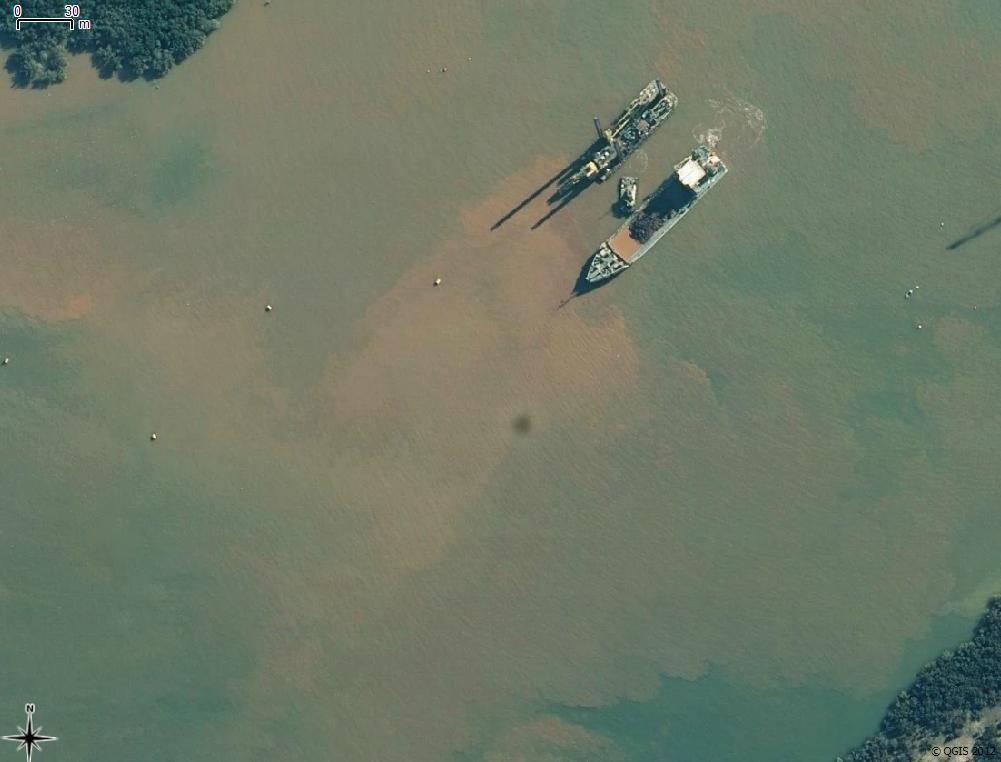
7 7 WorleyParsons Involvement: Driven by the need to collect regular high resolution imagery for aerial extent mapping (mangroves, seagrass, saltflats). Health and safety issues are high for manned flight. Costs are high for regular aircraft or satellite imagery (e.g. Dredge plume). WP successfully switched from diver-based to ROV coral monitoring. Hierarchy of controls: eliminate the risk!

8 8 WORLEY UAV: DRAGANFLYER X6 Designed for optical and TIR cameras 6 rotors for precise manoeuvrability 11 onboard stability sensors, including three gyros, three accelerometers, three magnetometers, one barometric pressure sensor, and one GPS receiver. Software for sensor integration and stability control GPS hold and navigation function for accurate photography. Real time telemetry display


9 9 Aspect Dimensions Mass Payload Maximum Speed Endurance Ceiling Motion sensors 11 Max Wind Speed Cameras Specifications 91 x 85 x 25 cm 1000 g 500 g 50 km/h 20 minutes 2,500 m 30 km/h 14.1 MP Leica mm optical Thermal IR Digital video recorder


10 10 SENSOR TYPES OBLIQUE CAMERA

11 11 SENSOR TYPES ORTHOPHOTO


12 SENSOR TYPES OTHER Thermal InfraRed (forward looking) Hyperspectral Air quality sampling (dust, hazardous gases) 12

13 POSITIONING TECHNIQUES GPS position hold. Use of ground control points (GCPs). Video transects, similar to towed underwater video analysis, effective for intertidal benthic habitat mapping. Advances in the ability to geocode images without the need for ground control points (GCP). Differential GPS, motion sensors and lens distortion models (e.g. Xiang & Tian, 2011). 13

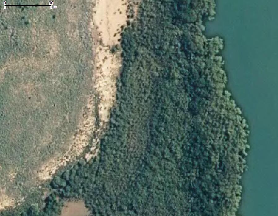
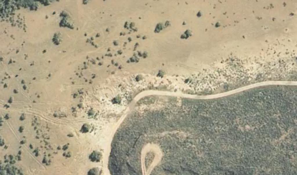
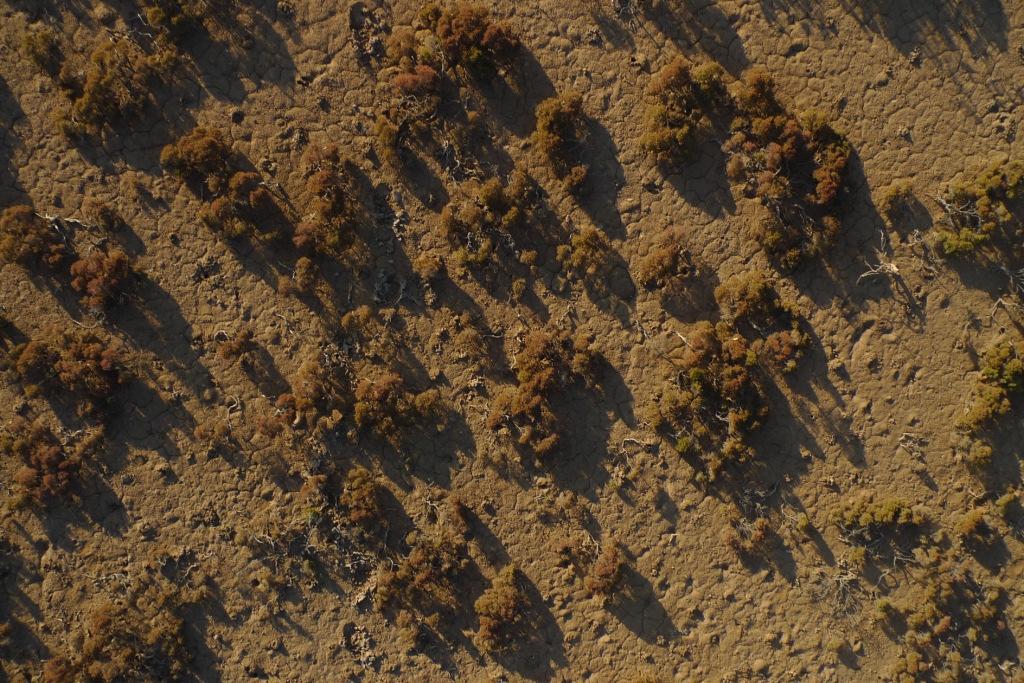
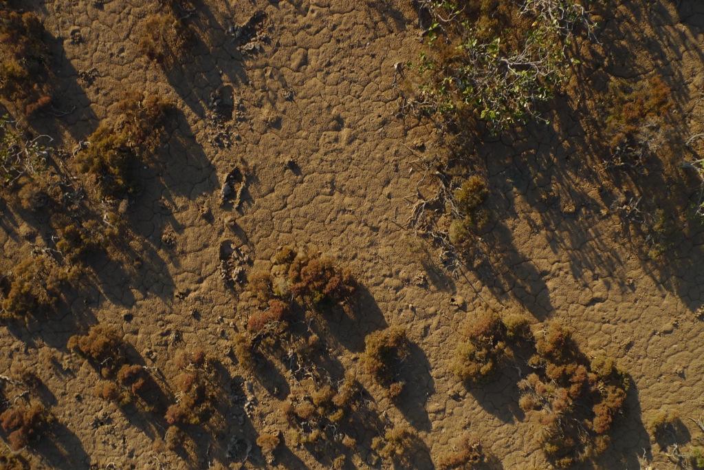
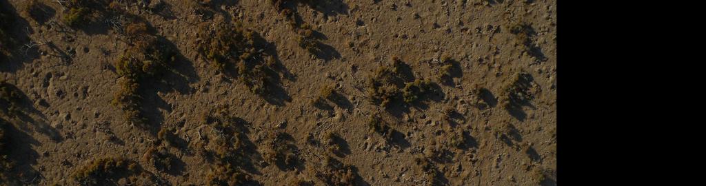
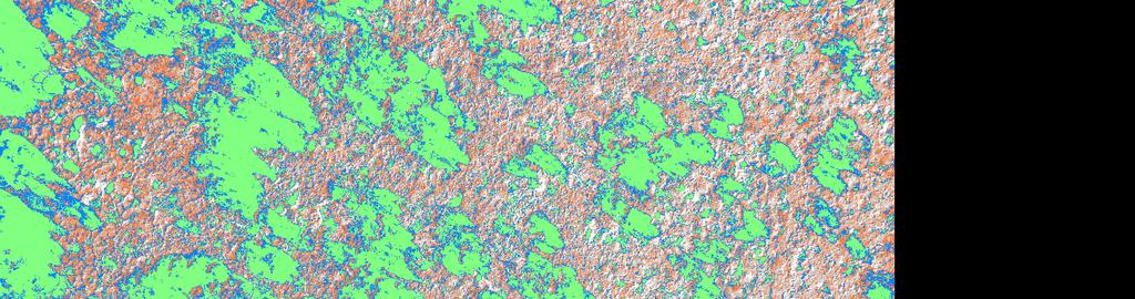
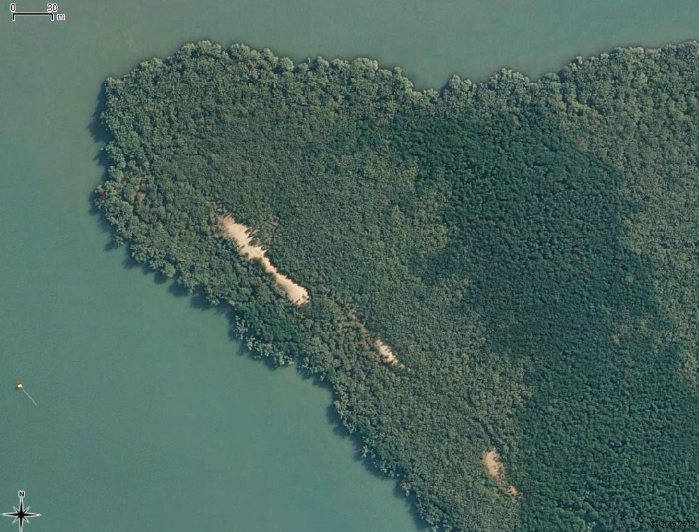
14 Assessing Intertidal Impacts Scope: repeat survey of mesoscale mangrove and samphire health quadrats Assess change in extent and canopy cover Also monitor dredging activity and plume extent Rapidly and frequently survey inaccessible areas with low health and safety risk!
15
16
17
18
19

20
21
22
23
24
 Class 2 Medical Certification UAV Controller Certificate Maintain flight and operations maintenance manuals")
25 LIMITATIONS Civil Aviation Safety Authority (CASA) Legal Requirements Business plan and concept of operations Safety case and Risk Assessment Agent/manufacturer training certification Private Pilots Licence (theory examinations only) Class 2 Medical Certification UAV Controller Certificate Maintain flight and operations maintenance manuals 25
.")
26 WHERE TO NEXT? Generation of 3D point clouds through stereophotography or LiDAR. Routine marine fauna observation (MFO) including cetaceans and turtle nesting activity (fixed wing). Minor oil spill contingency tracking. Hyper-spectral vegetation classification Detailed engineering inspections (e.g. Pipelines, offshore structures, thermal imaging). Health and safety intervention 26
27 Thank you Questions?
UAV Technologies for 3D Mapping. Rolf Schaeppi Director Geospatial Solutions APAC / India
 UAV Technologies for 3D Mapping Rolf Schaeppi Director Geospatial Solutions APAC / India Some main application areas? Market situation Analyst statements billion dollars 7,3 defense market 2,5 civil market
Aerial Image Acquisition and Processing Services. Ron Coutts, M.Sc., P.Eng. RemTech, October 15, 2014
 Aerial Image Acquisition and Processing Services Ron Coutts, M.Sc., P.Eng. RemTech, October 15, 2014 Outline Applications & Benefits Image Sources Aircraft Platforms Image Products Sample Images & Comparisons
Phase One 190MP Aerial System
 White Paper Phase One 190MP Aerial System Introduction Phase One Industrial s 100MP medium format aerial camera systems have earned a worldwide reputation for its high performance. They are commonly used
RPAS Photogrammetric Mapping Workflow and Accuracy
 RPAS Photogrammetric Mapping Workflow and Accuracy Dr Yincai Zhou & Dr Craig Roberts Surveying and Geospatial Engineering School of Civil and Environmental Engineering, UNSW Background RPAS category and
PEGASUS : a future tool for providing near real-time high resolution data for disaster management. Lewyckyj Nicolas
 PEGASUS : a future tool for providing near real-time high resolution data for disaster management Lewyckyj Nicolas nicolas.lewyckyj@vito.be http://www.pegasus4europe.com Overview Vito in a nutshell GI
Geo-localization and Mosaicing System (GEMS): Enabling Precision Image Feature Location and Rapid Mosaicing General:
: Enabling Precision Image Feature Location and Rapid Mosaicing General:") Geo-localization and Mosaicing System (GEMS): Enabling Precision Image Feature Location and Rapid Mosaicing General: info@senteksystems.com www.senteksystems.com 12/6/2014 Precision Agriculture Multi-Spectral
Geo-localization and Mosaicing System (GEMS): Enabling Precision Image Feature Location and Rapid Mosaicing General: info@senteksystems.com www.senteksystems.com 12/6/2014 Precision Agriculture Multi-Spectral
Module 3 Introduction to GIS. Lecture 8 GIS data acquisition
 Module 3 Introduction to GIS Lecture 8 GIS data acquisition GIS workflow Data acquisition (geospatial data input) GPS Remote sensing (satellites, UAV s) LiDAR Digitized maps Attribute Data Management Data
GEO 428: DEMs from GPS, Imagery, & Lidar Tuesday, September 11
 GEO 428: DEMs from GPS, Imagery, & Lidar Tuesday, September 11 Global Positioning Systems GPS is a technology that provides Location coordinates Elevation For any location with a decent view of the sky
Active and Passive Microwave Remote Sensing
 Active and Passive Microwave Remote Sensing Passive remote sensing system record EMR that was reflected (e.g., blue, green, red, and near IR) or emitted (e.g., thermal IR) from the surface of the Earth.
Introduction to Remote Sensing Fundamentals of Satellite Remote Sensing. Mads Olander Rasmussen
 Introduction to Remote Sensing Fundamentals of Satellite Remote Sensing Mads Olander Rasmussen (mora@dhi-gras.com) 01. Introduction to Remote Sensing DHI What is remote sensing? the art, science, and technology
Adaptation and Application of Aerospace and Defense Industry Technologies to the Oil and Gas Industry
 ELTA Systems Group & Subsidiary of ISRAEL AEROSPACE INDUSTRIES Adaptation and Application of Aerospace and Defense Industry Technologies to the Oil and Gas Industry Dr. Nathan Weiss Israel Aerospace Industries
Heterogeneous Control of Small Size Unmanned Aerial Vehicles
 Magyar Kutatók 10. Nemzetközi Szimpóziuma 10 th International Symposium of Hungarian Researchers on Computational Intelligence and Informatics Heterogeneous Control of Small Size Unmanned Aerial Vehicles
EnsoMOSAIC Aerial mapping tools
 EnsoMOSAIC Aerial mapping tools Jakarta and Kuala Lumpur, 2013 Contents MosaicMill MM Application examples Software introduction System introduction Rikola HS sensor UAV platform examples SW Syst HS UAV
USE OF IMPROVISED REMOTELY SENSED DATA FROM UAV FOR GIS AND MAPPING, A CASE STUDY OF GOMA CITY, DR CONGO
 USE OF IMPROVISED REMOTELY SENSED DATA FROM UAV FOR GIS AND MAPPING, A CASE STUDY OF GOMA CITY, DR CONGO Cung Chin Thang United Nations Global Support Center, Brindisi, Italy, Email: thang@un.org KEY WORDS:
MULTISPECTRAL AGRICULTURAL ASSESSMENT. Normalized Difference Vegetation Index. Federal Robotics INSPECTION & DOCUMENTATION
 MULTISPECTRAL AGRICULTURAL ASSESSMENT Normalized Difference Vegetation Index INSPECTION & DOCUMENTATION Federal Robotics Clearwater Dr. Amherst, New York 14228 716-221-4181 Sales@FedRobot.com www.fedrobot.com
22/11/2013. UAV: Overview of systems, applications and processing Kris Nackaerts, Peter Strigencz
 22/11/2013 UAV: Overview of systems, applications and processing Kris Nackaerts, Peter Strigencz Introduction» Systems» Applications» Non-imaging» Imaging» Processing, focus on photogrammetry» Use case
AERIAL SURVEYS COMPANY PROFILE
 AERIAL SURVEYS COMPANY PROFILE Aerial Surveys, previously known as GeoSmart, is an innovative aerial photography and geospatial mapping service provider Our services enable customers to make better business
Remote Sensing Platforms
 Types of Platforms Lighter-than-air Remote Sensing Platforms Free floating balloons Restricted by atmospheric conditions Used to acquire meteorological/atmospheric data Blimps/dirigibles Major role - news
UAV applications for oil spill detection, suspended matter distribution and ice monitoring first tests and trials in Estonia 2015/2016
 UAV applications for oil spill detection, suspended matter distribution and ice monitoring first tests and trials in Estonia 2015/2016 Sander Rikka Marine Systems Institute at TUT 1.11.2016 1 Outlook Introduction
Active and Passive Microwave Remote Sensing
 Active and Passive Microwave Remote Sensing Passive remote sensing system record EMR that was reflected (e.g., blue, green, red, and near IR) or emitted (e.g., thermal IR) from the surface of the Earth.
More with Less ROV Solutions to Offshore Challenges
 More with Less ROV Solutions to Offshore Challenges Content Introduction Operational Challenges Global Involvement with government and military agencies VALOR Versatile and Lightweight Observation ROV
Flood modelling and management. Glasgow University. 8 September Paul Shaw - GeoVision
 Flood modelling and management Glasgow University 8 September 2004 Paul Shaw - GeoVision How important are heights in flood modelling? Comparison of data collection technologies GPS - Global Positioning
Helicopter Aerial Laser Ranging
 Helicopter Aerial Laser Ranging Håkan Sterner TopEye AB P.O.Box 1017, SE-551 11 Jönköping, Sweden 1 Introduction Measuring distances with light has been used for terrestrial surveys since the fifties.
The studies began when the Tiros satellites (1960) provided man s first synoptic view of the Earth s weather systems.
 provided man s first synoptic view of the Earth s weather systems.") Remote sensing of the Earth from orbital altitudes was recognized in the mid-1960 s as a potential technique for obtaining information important for the effective use and conservation of natural resources.
Remote sensing of the Earth from orbital altitudes was recognized in the mid-1960 s as a potential technique for obtaining information important for the effective use and conservation of natural resources.
Debris Detection: Background, Efforts, & Lessons Learned. Peter Murphy Alaska Coordinator / Detection Lead NOAA Marine Debris Program
 Debris Detection: Background, Efforts, & Lessons Learned Peter Murphy Alaska Coordinator / Detection Lead NOAA Marine Debris Program Outline Marine Debris Issue Types Distribution Impacts NOAA Marine Debris
School of Rural and Surveying Engineering National Technical University of Athens
 Laboratory of Photogrammetry National Technical University of Athens Combined use of spaceborne optical and SAR data Incompatible data sources or a useful procedure? Charalabos Ioannidis, Dimitra Vassilaki
A map says to you, 'Read me carefully, follow me closely, doubt me not.' It says, 'I am the Earth in the palm of your hand. Without me, you are alone
 A map says to you, 'Read me carefully, follow me closely, doubt me not.' It says, 'I am the Earth in the palm of your hand. Without me, you are alone and lost. Beryl Markham (West With the Night, 1946
Using Norwegian competence from oil and gas subsea operations towards the development of ocean mining operations
 Using Norwegian competence from oil and gas subsea operations towards the development of ocean mining operations Yoshinori Miura, Jens Laugesen, Øyvind Fjukmoen, Lucy Brooks, Karsten Hagenah, Tor Jensen
NAVIGATION AND REMOTE SENSING PAYLOADS AND METHODS OF THE SARVANT UNMANNED AERIAL SYSTEM
 NAVIGATION AND REMOTE SENSING PAYLOADS AND METHODS OF THE SARVANT UNMANNED AERIAL SYSTEM P. Molina, P. Fortuny, I. Colomina Institute of Geomatics -- Castelldefels (ES) M. Remy, K.A.C. Macedo, Y.R.C. Zúnigo,
MSB Imagery Program FAQ v1
 MSB Imagery Program FAQ v1 (F)requently (A)sked (Q)uestions 9/22/2016 This document is intended to answer commonly asked questions related to the MSB Recurring Aerial Imagery Program. Table of Contents
USING UNMANNED AERIAL VEHICLES (UAV'S) TO MEASURE JELLYFISH AGGREGATIONS: AN INTER
 TO MEASURE JELLYFISH AGGREGATIONS: AN INTER") USING UNMANNED AERIAL VEHICLES (UAV'S) TO MEASURE JELLYFISH AGGREGATIONS: AN INTER COMPARISON WITH NET SAMPLING BRIAN P. V. HUNT University of British Columbia Institute for the Oceans and Fisheries Schaub,
USING UNMANNED AERIAL VEHICLES (UAV'S) TO MEASURE JELLYFISH AGGREGATIONS: AN INTER COMPARISON WITH NET SAMPLING BRIAN P. V. HUNT University of British Columbia Institute for the Oceans and Fisheries Schaub,
An Introduction to Geomatics. Prepared by: Dr. Maher A. El-Hallaq خاص بطلبة مساق مقدمة في علم. Associate Professor of Surveying IUG
 An Introduction to Geomatics خاص بطلبة مساق مقدمة في علم الجيوماتكس Prepared by: Dr. Maher A. El-Hallaq Associate Professor of Surveying IUG 1 Airborne Imagery Dr. Maher A. El-Hallaq Associate Professor
9/12/2011. Training Course Remote Sensing Basic Theory & Image Processing Methods September 2011
 Training Course Remote Sensing Basic Theory & Image Processing Methods 19 23 September 2011 Remote Sensing Platforms Michiel Damen (September 2011) damen@itc.nl 1 Overview Platforms & missions aerial surveys
The Oil & Gas Industry Requirements for Marine Robots of the 21st century
 The Oil & Gas Industry Requirements for Marine Robots of the 21st century www.eninorge.no Laura Gallimberti 20.06.2014 1 Outline Introduction: fast technology growth Overview underwater vehicles development
LAST GENERATION UAV-BASED MULTI- SPECTRAL CAMERA FOR AGRICULTURAL DATA ACQUISITION
 LAST GENERATION UAV-BASED MULTI- SPECTRAL CAMERA FOR AGRICULTURAL DATA ACQUISITION FABIO REMONDINO, Erica Nocerino, Fabio Menna Fondazione Bruno Kessler Trento, Italy http://3dom.fbk.eu Marco Dubbini,
Intelligent Sensor Platforms for Remotely Piloted and Unmanned Vehicles. Dr. Nick Krouglicof 14 June 2012
 Intelligent Sensor Platforms for Remotely Piloted and Unmanned Vehicles Dr. Nick Krouglicof 14 June 2012 Project Overview Project Duration September 1, 2010 to June 30, 2016 Primary objective(s) / outcomes
Abstract. 1. Introduction
 Title: Satellite surveillance for maritime border monitoring Author: H. Greidanus Number: File: GMOSSBordMon1-2.doc Version: 1-2 Project: GMOSS Date: 25 Aug 2004 Distribution: Abstract Present day remote
Drones and Ham Radio. Bob Schatzman KD9AAD
 Drones and Ham Radio Bob Schatzman KD9AAD Not Your Childhood RC Toy! Highly Accurate GPS receiver! Magnetic Compass! R/C Transmitter/Receiver! Accelerometers/Gyros! HDTV & HQ Still Camera on a Smart Gimbal!
Unmanned Aerial Vehicle Data Acquisition for Damage Assessment in. Hurricane Events
 Unmanned Aerial Vehicle Data Acquisition for Damage Assessment in Hurricane Events Stuart M. Adams a Carol J. Friedland b and Marc L. Levitan c ABSTRACT This paper examines techniques for data collection
Consumer digital CCD cameras
 CAMERAS Consumer digital CCD cameras Leica RC-30 Aerial Cameras Zeiss RMK Zeiss RMK in aircraft Vexcel UltraCam Digital (note multiple apertures Lenses for Leica RC-30. Many elements needed to minimize
Automation at Depth: Ocean Infinity and seabed mapping using multiple AUVs
 Automation at Depth: Ocean Infinity and seabed mapping using multiple AUVs Ocean Infinity s seabed mapping campaign commenced in the summer of 2017. The Ocean Infinity team is made up of individuals from
MSRC Tactical Oil Spill Surveillance and Remote Sensing
 MSRC Tactical Oil Spill Surveillance and Remote Sensing Industry Technical Advisory Committee for Oil spill Response October 25, 2016 0 Historical Perspective -- Oil Spill Surveillance in U.S Exxon Valdez
SAFE TO SEA (S2S) FOR THE SAFETY OF NAVIGTION.
 FOR THE SAFETY OF NAVIGTION.") SAFE TO SEA (S2S) FOR THE SAFETY OF NAVIGTION. GRAFINTA.S.A. Company founded in 1964 and located in Madrid. With 11 people on our payroll from which 8 are engineers specialized in new technologies and
SAFE TO SEA (S2S) FOR THE SAFETY OF NAVIGTION. GRAFINTA.S.A. Company founded in 1964 and located in Madrid. With 11 people on our payroll from which 8 are engineers specialized in new technologies and
Towards a Management Plan for a Tropical Reef-Lagoon System Using Airborne Multispectral Imaging and GIS
 Towards a Management Plan for a Tropical Reef-Lagoon System Using Airborne Multispectral Imaging and GIS This paper was presented at the Fourth International Conference on Remote Sensing for Marine and
GPS-Aided INS Datasheet Rev. 3.0
 1 GPS-Aided INS The Inertial Labs Single and Dual Antenna GPS-Aided Inertial Navigation System INS is new generation of fully-integrated, combined GPS, GLONASS, GALILEO, QZSS, BEIDOU and L-Band navigation
Remote Sensing is the observation of the Earth from satellites or aircrafts.
 Remote Sensing? Remote Sensing is the observation of the Earth from satellites or aircrafts. Sensors mounted on these platforms capture images of the Earth that reveal features may or may not apparent
Five Sensors, One Day: Unmanned vs. Manned Logistics and Accuracy
 Five Sensors, One Day: Unmanned vs. Manned Logistics and Accuracy ASPRS UAS Mapping Technical Symposium Sept 13 th, 2016 Presenter: David Day, CP, GISP Keystone Aerial Surveys, Inc. Summary of activities
Monitoring the vegetation success of a rehabilitated mine site using multispectral UAV imagery. Tim Whiteside & Renée Bartolo, eriss
 Monitoring the vegetation success of a rehabilitated mine site using multispectral UAV imagery Tim Whiteside & Renée Bartolo, eriss About the Supervising Scientist Main roles Working to protect the environment
INTRODUCTORY REMOTE SENSING. Geob 373
 INTRODUCTORY REMOTE SENSING Geob 373 Landsat 7 15 m image highlighting the geology of Oman http://www.satimagingcorp.com/gallery-landsat.html ASTER 15 m SWIR image, Escondida Mine, Chile http://www.satimagingcorp.com/satellite-sensors/aster.html
GPS-Aided INS Datasheet Rev. 2.6
 GPS-Aided INS 1 GPS-Aided INS The Inertial Labs Single and Dual Antenna GPS-Aided Inertial Navigation System INS is new generation of fully-integrated, combined GPS, GLONASS, GALILEO and BEIDOU navigation
HIGH RESOLUTION IMAGERY FOR MAPPING AND LANDSCAPE MONITORING
 HIGH RESOLUTION IMAGERY FOR MAPPING AND LANDSCAPE MONITORING Karsten Jacobsen Leibniz University Hannover, Institute of Photogrammetry and Geoinformation Nienburger Str. 1, 30165 Hannover, Germany, jacobsen@ipi.uni-hannover.de
EVALUATION OF PLEIADES-1A TRIPLET ON TRENTO TESTFIELD
 EVALUATION OF PLEIADES-1A TRIPLET ON TRENTO TESTFIELD D. Poli a, F. Remondino b, E. Angiuli c, G. Agugiaro b a Terra Messflug GmbH, Austria b 3D Optical Metrology Unit, Fondazione Bruno Kessler, Trento,
Govt. Engineering College Jhalawar Model Question Paper Subject- Remote Sensing & GIS
 Govt. Engineering College Jhalawar Model Question Paper Subject- Remote Sensing & GIS Time: Max. Marks: Q1. What is remote Sensing? Explain the basic components of a Remote Sensing system. Q2. What is
Overview of how remote sensing is used by the wildland fire community.
 Overview of how remote sensing is used by the wildland fire community. Presented to the ASEN 6210 Remote Sensing Seminar on 2/18/04 by: Jeff Baranyi ESRI Denver Reported by Gary Fager. Images are from
The brain for the plane is the Airelectronics' U-Pilot flight control system, which is embedded inside the plane's fuselage, leaving a lot of space on
 Airelectronics has developed a new complete solution meeting the needs of the farming science. The completely test Skywalkerplatform has been equipped with both thermal and multispectral cameras to measure
UAV PHOTOGRAMMETRY COMPARED TO TRADITIONAL RTK GPS SURVEYING
 UAV PHOTOGRAMMETRY COMPARED TO TRADITIONAL RTK GPS SURVEYING Brad C. Mathison and Amber Warlick March 20, 2016 Fearless Eye Inc. Kansas City, Missouri www.fearlesseye.com KEY WORDS: UAV, UAS, Accuracy
TESTFIELD TRENTO: GEOMETRIC EVALUATION OF VERY HIGH RESOLUTION SATELLITE IMAGERY
 TESTFIELD TRENTO: GEOMETRIC EVALUATION OF VERY HIGH RESOLUTION SATELLITE IMAGERY G. AGUGIAROa, D. POLIb, F. REMONDINOa, 3DOM, 3D Optical Metrology Unit Bruno Kessler Foundation, Trento, Italy a b Vermessung
Visual inspection strategies for large bridges using Unmanned Aerial Vehicles (UAV)
") Visual inspection strategies for large bridges using Unmanned Aerial Vehicles (UAV) Norman Hallermann & Guido Morgenthal Bauhaus-Universität Weimar, Chair of Modeling and Simulation of Structures, Weimar,
Visual inspection strategies for large bridges using Unmanned Aerial Vehicles (UAV) Norman Hallermann & Guido Morgenthal Bauhaus-Universität Weimar, Chair of Modeling and Simulation of Structures, Weimar,
FLCS V2.1. AHRS, Autopilot, Gyro Stabilized Gimbals Control, Ground Control Station
 AHRS, Autopilot, Gyro Stabilized Gimbals Control, Ground Control Station The platform provides a high performance basis for electromechanical system control. Originally designed for autonomous aerial vehicle
Fugro Worldwide Fugro Environmental
 1 2 Fugro Worldwide The Fugro group of companies is an international consulting company that provides measurements and interpretations of data related to the earth's surface and the soils and rocks beneath.
HALS-H1 Ground Surveillance & Targeting Helicopter
 ARATOS-SWISS Homeland Security AG & SMA PROGRESS, LLC HALS-H1 Ground Surveillance & Targeting Helicopter Defense, Emergency, Homeland Security (Border Patrol, Pipeline Monitoring)... Automatic detection
LECTURE NOTES 2016 CONTENTS. Sensors and Platforms for Acquisition of Aerial and Satellite Image Data
 LECTURE NOTES 2016 Prof. John TRINDER School of Civil and Environmental Engineering Telephone: (02) 9 385 5020 Fax: (02) 9 313 7493 j.trinder@unsw.edu.au CONTENTS Chapter 1 Chapter 2 Sensors and Platforms
MANNED AIRBORNE REAL-TIME SURVEILLANCE OBSERVATION SYSTEM
 MARSO WWW.MARSO.AERO MANNED AIRBORNE REAL-TIME SURVEILLANCE OBSERVATION & SYSTEM THE MARSO SYSTEM is a versatile surveillance system for a large class of missions ranging from large area ship detection
MPA Baseline Program. Annual Progress Report
 MPA Baseline Program Annual Progress Report Principal Investigators please use this form to submit your MPA Baseline Program project annual report, including an update on activities completed over the
Sensor set stabilization system for miniature UAV
 Sensor set stabilization system for miniature UAV Wojciech Komorniczak 1, Tomasz Górski, Adam Kawalec, Jerzy Pietrasiński Military University of Technology, Institute of Radioelectronics, Warsaw, POLAND
LPIS Orthoimagery An assessment of the Bing imagery for LPIS purpose
 LPIS Orthoimagery An assessment of the Bing imagery for LPIS purpose Slavko Lemajić Wim Devos, Pavel Milenov GeoCAP Action - MARS Unit - JRC Ispra Tallinn, 24 th November 2011 Outline JRC`s Ortho specifications
UAV BASED MONITORING SYSTEM AND OBJECT DETECTION TECHNIQUE DEVELOPMENT FOR A DISASTER AREA
 UAV BASED MONITORING SYSTEM AND OBJECT DETECTION TECHNIQUE DEVELOPMENT FOR A DISASTER AREA Afzal Ahmed 1, Dr. Masahiko Nagai 2, Dr. Chen Tianen 2, Prof. Ryosuke SHIBASAKI The University of Tokyo Shibasaki
The Research of Real-Time UAV Inspection System for Photovoltaic Power Station Based on 4G Private Network
 Journal of Computers Vol. 28, No. 2, 2017, pp. 189-196 doi:10.3966/199115592017042802014 The Research of Real-Time UAV Inspection System for Photovoltaic Power Station Based on 4G Private Network Mei-Ling
Annual Progress Report for Makaha Valley Vegetation Mapping Analysis Project Update: January 1, 2014 September 30 th, 2014
 Annual Progress Report for Makaha Valley Vegetation Mapping Analysis Project Update: January 1, 2014 September 30 th, 2014 Evaluation of Three Very High Resolution Remote Sensing Technologies for Vegetation
The Normal Baseline. Dick Gent Law of the Sea Division UK Hydrographic Office
 The Normal Baseline Dick Gent Law of the Sea Division UK Hydrographic Office 2 The normal baseline for measuring the breadth of the territorial sea is the low water line along the coast as marked on large
Tutorial 10 Information extraction from high resolution optical satellite sensors
 Tutorial 10 Information extraction from high resolution optical satellite sensors Karsten Jacobsen 1, Emmanuel Baltsavias 2, David Holland 3 1 University of, Nienburger Strasse 1, D-30167, Germany, jacobsen@ipi.uni-hannover.de
Practical Uses of Satellite Data in Forest Management
 Practical Uses of Satellite Data in Forest Management GCFF Conference April 2018 Copernicus: Sentinel-2 The Optical Imaging Mission for Land Services 1 Uses for Satellite Imagery 1. Introduction 2. Satellite
to Geospatial Technologies
 What s in a Pixel? A Primer for Remote Sensing What s in a Pixel Development UNH Cooperative Extension Geospatial Technologies Training Center Shane Bradt UConn Cooperative Extension Geospatial Technology
Progress Report 2: Strategic Planning for the Far Eastern Curlew
 Progress Report 2: Strategic Planning for the Far Eastern Curlew December 2017 Progress Report 2: Strategic Planning for the Far Eastern Curlew Project team: Amanda Lilleyman, Stephen Garnett, Hamish Campbell,
U-Pilot can fly the aircraft using waypoint navigation, even when the GPS signal has been lost by using dead-reckoning navigation. Can also orbit arou
 We offer a complete solution for a user that need to put a payload in a advanced position at low cost completely designed by the Spanish company Airelectronics. Using a standard computer, the user can
RADIOMETRIC AND GEOMETRIC CHARACTERISTICS OF PLEIADES IMAGES
 RADIOMETRIC AND GEOMETRIC CHARACTERISTICS OF PLEIADES IMAGES K. Jacobsen a, H. Topan b, A.Cam b, M. Özendi b, M. Oruc b a Leibniz University Hannover, Institute of Photogrammetry and Geoinformation, Germany;
OIL SPILLS IN ICE Remote Sensing
 OIL SPILLS IN ICE Remote Sensing Technology Overview and Upcoming JIP Research David Dickins Chevron IOSC2014 Savannah COLLABORATION AMONG TEN COMPANIES International arctic research programme Builds upon
The Hyperspectral UAV (HyUAV) a novel UAV-based spectroscopy tool for environmental monitoring
 a novel UAV-based spectroscopy tool for environmental monitoring") The Hyperspectral UAV (HyUAV) a novel UAV-based spectroscopy tool for environmental monitoring R. Garzonio 1, S. Cogliati 1, B. Di Mauro 1, A. Zanin 2, B. Tattarletti 2, F. Zacchello 2, P. Marras 2 and
The Hyperspectral UAV (HyUAV) a novel UAV-based spectroscopy tool for environmental monitoring R. Garzonio 1, S. Cogliati 1, B. Di Mauro 1, A. Zanin 2, B. Tattarletti 2, F. Zacchello 2, P. Marras 2 and
Autonomous Underwater Vehicles
 Autonomous Underwater Vehicles A View of the Autonomous Underwater Vehicle Market For a number of years now the Autonomous Underwater Vehicle (AUV) has been the undisputed tool of choice for certain niche
Stratollites set to provide persistent-image capability
 Stratollites set to provide persistent-image capability [Content preview Subscribe to Jane s Intelligence Review for full article] Persistent remote imaging of a target area is a capability previously
ASSEMBLY OF A REMOTELY PILOTED AIRCRAFT OF LOW COST APPLIED TO AGRICULTURE
 Journal of the Brazilian Association of Agricultural Engineering ISSN: 1809-4430 (on-line) TECHNICAL PAPER ASSEMBLY OF A REMOTELY PILOTED AIRCRAFT OF LOW COST APPLIED TO AGRICULTURE Doi:http://dx.doi.org/10.1590/1809-4430-Eng.Agric.v37n6p1268-1274/2017
PRODUCT OVERVIEW FOR THE. Corona 350 II FLIR SYSTEMS POLYTECH AB
 PRODUCT OVERVIEW FOR THE Corona 350 II FLIR SYSTEMS POLYTECH AB Table of Contents Table of Contents... 1 Introduction... 2 Overview... 2 Purpose... 2 Airborne Data Acquisition and Management Software (ADAMS)...
GPS System Design and Control Modeling. Chua Shyan Jin, Ronald. Assoc. Prof Gerard Leng. Aeronautical Engineering Group, NUS
 GPS System Design and Control Modeling Chua Shyan Jin, Ronald Assoc. Prof Gerard Leng Aeronautical Engineering Group, NUS Abstract A GPS system for the autonomous navigation and surveillance of an airship
SENSITIVITY ANALYSIS OF UAV-PHOTOGRAMMETRY FOR CREATING DIGITAL ELEVATION MODELS (DEM)
") SENSITIVITY ANALYSIS OF UAV-PHOTOGRAMMETRY FOR CREATING DIGITAL ELEVATION MODELS (DEM) G. Rock a, *, J.B. Ries b, T. Udelhoven a a Dept. of Remote Sensing and Geomatics. University of Trier, Behringstraße,
SENSITIVITY ANALYSIS OF UAV-PHOTOGRAMMETRY FOR CREATING DIGITAL ELEVATION MODELS (DEM) G. Rock a, *, J.B. Ries b, T. Udelhoven a a Dept. of Remote Sensing and Geomatics. University of Trier, Behringstraße,
Distant Imagery. Innovation. Creativity. Passion.
 Distant Imagery 2017 Innovation. Creativity. Passion www.distantimagery.com Introduction The only way to do great work is to love what you do. We are passionate about utilising imagery as a key mechanism
Aerial efficiency, photogrammetric accuracy
 Aerial efficiency, photogrammetric accuracy Why sensefly 3 reasons to choose the ebee Plus Large coverage for optimal efficiency The ebee Plus can map more square kilometres per flight, than any drone
CODEVINTEC. Miniature and accurate IMU, AHRS, INS/GNSS Attitude and Heading Reference Systems
 45 27 39.384 N 9 07 30.145 E Miniature and accurate IMU, AHRS, INS/GNSS Attitude and Heading Reference Systems Aerospace Land/Automotive Marine Subsea Miniature inertial sensors 0.1 Ellipse Series New
Ground Control Configuration Analysis for Small Area UAV Imagery Based Mapping
 Ground Control Configuration Analysis for Small Area UAV Imagery Based Mapping ASPRS IGTF 2017, Baltimore, MD March 15 th, 2017 Presenter: David Day, CP, GISP Wes Weaver Keystone Aerial Surveys, Inc. Summary
NON-PHOTOGRAPHIC SYSTEMS: Multispectral Scanners Medium and coarse resolution sensor comparisons: Landsat, SPOT, AVHRR and MODIS
 NON-PHOTOGRAPHIC SYSTEMS: Multispectral Scanners Medium and coarse resolution sensor comparisons: Landsat, SPOT, AVHRR and MODIS CLASSIFICATION OF NONPHOTOGRAPHIC REMOTE SENSORS PASSIVE ACTIVE DIGITAL
MULTI-TEMPORAL SATELLITE IMAGES WITH BATHYMETRY CORRECTION FOR MAPPING AND ASSESSING SEAGRASS BED CHANGES IN DONGSHA ATOLL
 MULTI-TEMPORAL SATELLITE IMAGES WITH BATHYMETRY CORRECTION FOR MAPPING AND ASSESSING SEAGRASS BED CHANGES IN DONGSHA ATOLL Chih -Yuan Lin and Hsuan Ren Center for Space and Remote Sensing Research, National
Advances in Underwater Mining and Associated Technology EC Workshop Brussels, June 2014
 Advances in Underwater Mining and Associated Technology EC Workshop Brussels, June 2014 GLOBAL SITUATION 70% of the earth is covered in water Around half of this is in territorial waters, and half in international
Remote Sensing Platforms
 Remote Sensing Platforms Remote Sensing Platforms - Introduction Allow observer and/or sensor to be above the target/phenomena of interest Two primary categories Aircraft Spacecraft Each type offers different
Validation of the QuestUAV PPK System
 Validation of the QuestUAV PPK System 3cm in xy, 400ft, no GCPs, 100Ha, 25 flights Nigel King 1, Kerstin Traut 2, Cameron Weeks 3 & Ruairi Hardman 4 1 Director QuestUAV, 2 Data Analyst QuestUAV, 3 Production
TRACS A-B-C Acquisition and Processing and LandSat TM Processing
 TRACS A-B-C Acquisition and Processing and LandSat TM Processing Mark Hess, Ocean Imaging Corp. Kevin Hoskins, Marine Spill Response Corp. TRACS: Level A AIRCRAFT Ocean Imaging Corporation Multispectral/TIR
Photonic-based spectral reflectance sensor for ground-based plant detection and weed discrimination
 Research Online ECU Publications Pre. 211 28 Photonic-based spectral reflectance sensor for ground-based plant detection and weed discrimination Arie Paap Sreten Askraba Kamal Alameh John Rowe 1.1364/OE.16.151
Overview. Objectives. The ultimate goal is to compare the performance that different equipment offers us in a photogrammetric flight.
 Overview At present, one of the most commonly used technique for topographic surveys is aerial photogrammetry. This technique uses aerial images to determine the geometric properties of objects and spatial
REMOTE SENSING. Topic 10 Fundamentals of Digital Multispectral Remote Sensing MULTISPECTRAL SCANNERS MULTISPECTRAL SCANNERS
 REMOTE SENSING Topic 10 Fundamentals of Digital Multispectral Remote Sensing Chapter 5: Lillesand and Keifer Chapter 6: Avery and Berlin MULTISPECTRAL SCANNERS Record EMR in a number of discrete portions
746A27 Remote Sensing and GIS. Multi spectral, thermal and hyper spectral sensing and usage
 746A27 Remote Sensing and GIS Lecture 3 Multi spectral, thermal and hyper spectral sensing and usage Chandan Roy Guest Lecturer Department of Computer and Information Science Linköping University Multi
Introduction Objective and Scope p. 1 Generic Requirements p. 2 Basic Requirements p. 3 Surveillance System p. 3 Content of the Book p.
 Preface p. xi Acknowledgments p. xvii Introduction Objective and Scope p. 1 Generic Requirements p. 2 Basic Requirements p. 3 Surveillance System p. 3 Content of the Book p. 4 References p. 6 Maritime
GPS-Aided INS Datasheet Rev. 2.7
 1 The Inertial Labs Single and Dual Antenna GPS-Aided Inertial Navigation System INS is new generation of fully-integrated, combined GPS, GLONASS, GALILEO, QZSS and BEIDOU navigation and highperformance