Multiplatform Remote Sensing for Coral Reef Community Assessment
|
|
|
- Laurence Jennings
- 5 years ago
- Views:
Transcription


1 Multiplatform Remote Sensing for Coral Reef Community Assessment Quinta Reunión Nacional de Percepción Remota y Sistemas de Información Geográfica en Puerto Rico September 27, 2007 Roy A. Armstrong, Ph. D. Bio-Optical Oceanography Laboratory University of Puerto Rico, Mayaguez Campus

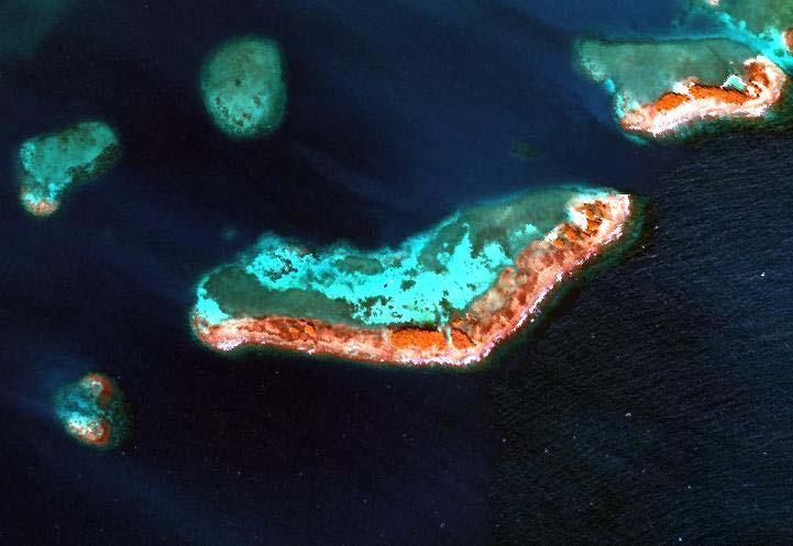
2 Bathymetry of Puerto Rico -Virgin Islands Geological Platform Potential Reef Habitat


 Ship-based Acoustic")

3 Remote Sensing Platforms and Sensor Requirements for Benthic Habitat Assessments Insular Shelf (0-30 m) Satellite Sensors Landsat TM, SPOT, IKONOS Airborne Sensors AVIRIS, AISA, Digital Camera Systems Upper Insular Slope ( m) Ship-based Acoustic Sensors Autonomous Underwater Vehicles (AUV) Optical and Acoustic Imaging Remote Operated Vehicles (ROV) Optical Imaging

4 Direct vs. Indirect Monitoring of Coral Reefs Using Remote Sensing Direct includes benthic mapping and characterization of coral reef and other biotopes using a sensor down approach. Requires local knowledge of reef communities and utilizes image-specific statistics to drive a supervised classification. Requires atmospheric and water column corrections for multi-temporal analysis. Landsat TM data for Los Roques, Venezuela: Benthic Habitat Map Seagrass Biomass Map
 and bleaching events. Low salinities and high turbidity from episodic rainfall events.")
5 Direct vs. Indirect Monitoring of Coral Reefs Using Remote Sensing, cont. Indirect addresses the oceanic environment around the reef. Sea surface temperatures (SSTs) and bleaching events. Low salinities and high turbidity from episodic rainfall events. Water optical properties (AOP and IOP) and coral reef parameters. MODIS K490 November 20, 2003

6 MODIS Time Series of K490 and Chlorophyll Associated with the November 13-15, 2003 Episodic Rainfall Event 0.40 K 490 (m -1 ) Chlorophyll (mg m 3 ) Distance (km) Julian days Rainfall Event
7 Indirect Methods: Kd (PAR) vs. Percent Coral Cover Irradiance Profiles for Sampling Stations E d (μmol s-1 m-2) K d vs Percent Coral Cover Depth (m) Las Coronas Media Luna Puerto Canoa Puerto de Botes Turmalin Oceanica Manchas Atunera South of Margarita Reef Shelf Edge South of Turrumote K d :0.148 y = 585.4e x R 2 = K d % CC K d K d
8 Reef-Up Habitat Mapping Physics based, uses Radiative Transfer Theory Uses spectral libraries of the reef components Its application is independent of site and image-specific statistics. Reflectance (%) Spectral Reflectance of Nine Scleractinian Species Prp Acc Aga Mna Dis Fav Pra Dps Dpc Wavelength (nm)


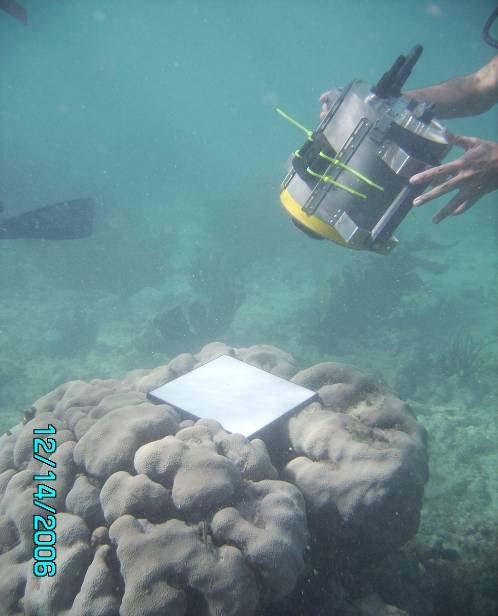
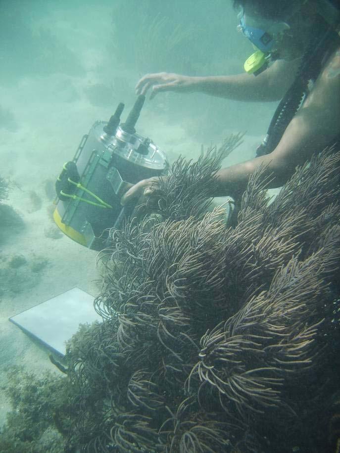
9 Spectral Library of Coral Reef Benthic Components Spectral Reflectance Data using GER-1500 Spectroradiometer


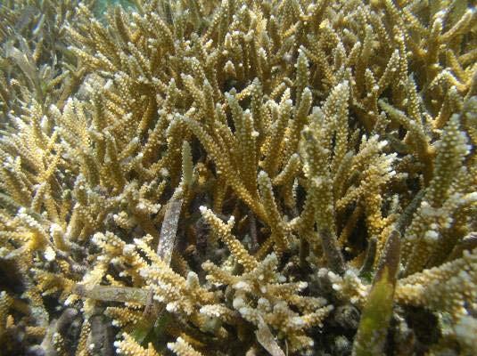
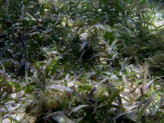
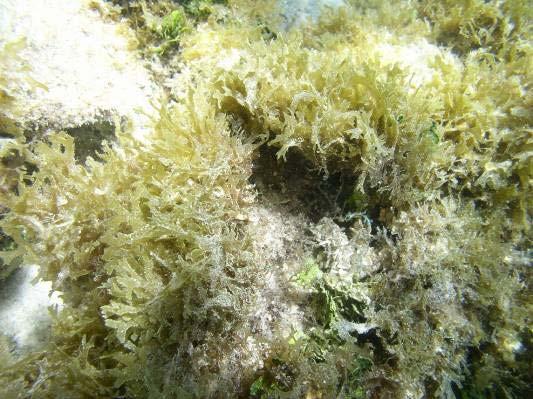
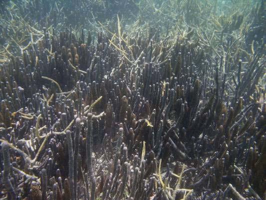
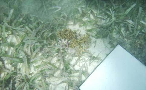
10 Coral Reef Benthic Components Coral Rubble Acropora cervicornis Montastraea annularis Gorgonians Siderastrea siderea Porites porites Dictyota spp. Thalassia testudinum

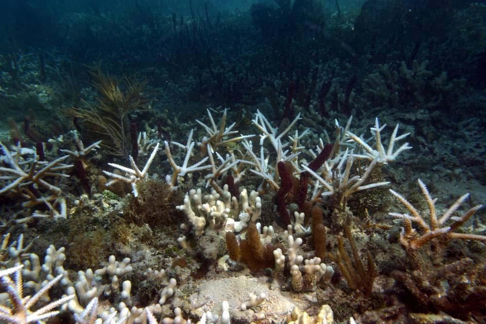
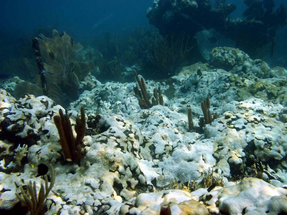
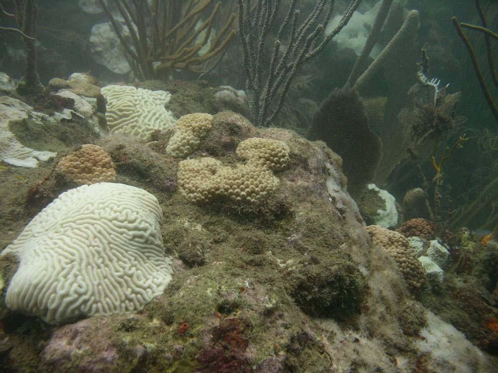
11 Coral Reef Bleaching


12 Coral Bleaching Spectral Response


13 Spatial Resolution Requirements for Coral Bleaching Detection Landsat 30 m IKONOS 1m 1 m SPOT 20 m CASI 5 m

14 Sub-meter Digital Camera Imagery NASA s Cirrus Digital Camera System (DCS) Hasselblad camera body, Kodak camera back and CCD array cm resolution from 12,000 Fireball Information Technologies DCS 16 Mpixel camera 7 cm at 3,000 NASA DCS - St. Croix, USVI FIT DCS La Parguera
 224")


15 AVIRIS 2005 Hyperspectral Mission Airborne Visible-Infrared Imaging Spectrometer (AVIRIS) 224 spectral bands 224 Spectral Bands, nm Spectral Resolution 10 nm Twin Otter Aircraft Puerto Rico Flighlines December 12-13, 2005 Altitude 3.5 km Pixel Size ~3.5 m Flight lines for La Parguera, Southwestern PR 26 Flighlines Solar azimuth lines
16 Atmospherically-Corrected AVIRIS Image
17 Water Column Corrections Lyzenga s depth invariant bands where Benthic Reflectance Model Empirical Line Method Relies on field measurements of homogeneous area or flat fields DN(b) = ρ(b)a(b) + B(b) ρ = reflectance of surface material A = multiplicative term, B = additive term
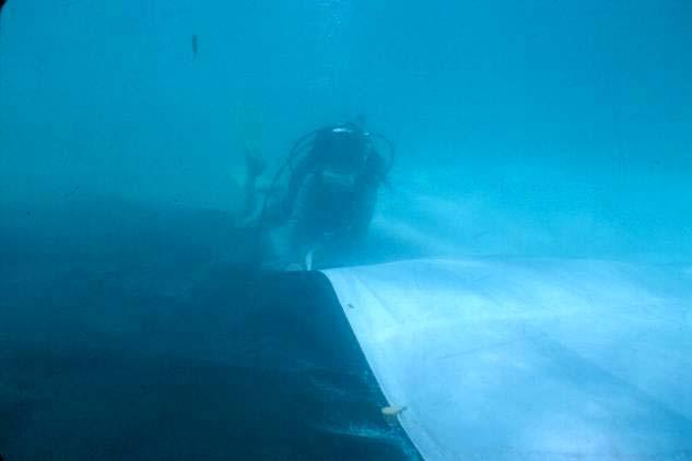
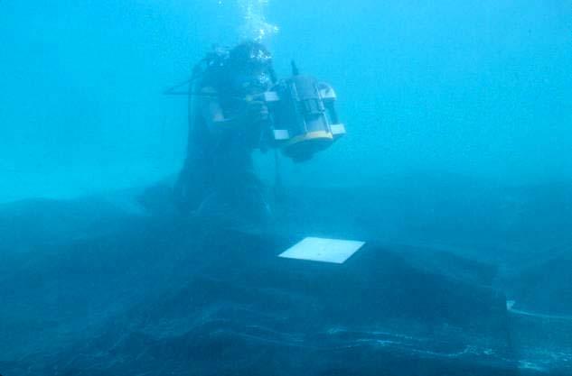

18 Underwater Flat-Field Calibration Targets for Water Column Correction


19 Water Column Correction Validation AVIRIS agrees with field values within 10% from nm and up to 18% between nm. Spectral features are preserved, mostly corresponding to pigment absorption by microbial layers.


20 AVIRIS Benthic Spectra After Water Column Correction Sand Seagrass Coral


 Puerto Rico")


21 Acknowledgements Fernando Gilbes, Liane Guild,Yasmin Detrés, Juan Torres, and Maria Cardona Sponsored by: NOAA (DNER) Puerto Rico Coral Reef Monitoring Grant NASA Ocean Biogeochemistry Program Center for Subsurface Sensing and Imaging (CenSSIS) NSF
MULTI-TEMPORAL SATELLITE IMAGES WITH BATHYMETRY CORRECTION FOR MAPPING AND ASSESSING SEAGRASS BED CHANGES IN DONGSHA ATOLL
 MULTI-TEMPORAL SATELLITE IMAGES WITH BATHYMETRY CORRECTION FOR MAPPING AND ASSESSING SEAGRASS BED CHANGES IN DONGSHA ATOLL Chih -Yuan Lin and Hsuan Ren Center for Space and Remote Sensing Research, National
Shallow Water Remote Sensing
 Shallow Water Remote Sensing John Hedley, IOCCG Summer Class 2018 Overview - different methods and applications Physics-based model inversion methods High spatial resolution imagery and Sentinel-2 Bottom
NASA airborne AVIRIS and DCS remote sensing of coral reefs
 Proceedings of the 11 th International Coral Reef Symposium, Ft. Lauderdale, Florida, 7 11 July 2008 Session number 17 NASA airborne AVIRIS and DCS remote sensing of coral reefs L. Guild 1, B. Lobitz 2,
CALMIT Field Program. Center for Advanced Land Management Information Technologies (CALMIT) University of Nebraska Lincoln
 University of Nebraska Lincoln") CALMIT Field Program Center for Advanced Land Management Information Technologies (CALMIT) University of Nebraska Lincoln Field Program: Three Areas Agriculture Surface Waters Coastal / Marine 1) Agriculture
CALMIT Field Program Center for Advanced Land Management Information Technologies (CALMIT) University of Nebraska Lincoln Field Program: Three Areas Agriculture Surface Waters Coastal / Marine 1) Agriculture
Coral Reef Remote Sensing
 Coral Reef Remote Sensing Spectral, Spatial, Temporal Scaling Phillip Dustan Sensor Spatial Resolutio n Number of Bands Useful Bands coverage cycle Operation Landsat 80m 2 2 18 1972-97 Thematic 30m 7
Application of Linear Spectral unmixing to Enrique reef for classification
 Application of Linear Spectral unmixing to Enrique reef for classification Carmen C. Zayas-Santiago University of Puerto Rico Mayaguez Marine Sciences Department Stefani 224 Mayaguez, PR 00681 c_castula@hotmail.com
IDENTIFICATION AND MAPPING OF HAWAIIAN CORAL REEFS USING HYPERSPECTRAL REMOTE SENSING
 IDENTIFICATION AND MAPPING OF HAWAIIAN CORAL REEFS USING HYPERSPECTRAL REMOTE SENSING Jessica Frances N. Ayau College of Education University of Hawai i at Mānoa Honolulu, HI 96822 ABSTRACT Coral reefs
NON-PHOTOGRAPHIC SYSTEMS: Multispectral Scanners Medium and coarse resolution sensor comparisons: Landsat, SPOT, AVHRR and MODIS
 NON-PHOTOGRAPHIC SYSTEMS: Multispectral Scanners Medium and coarse resolution sensor comparisons: Landsat, SPOT, AVHRR and MODIS CLASSIFICATION OF NONPHOTOGRAPHIC REMOTE SENSORS PASSIVE ACTIVE DIGITAL
3/31/03. ESM 266: Introduction 1. Observations from space. Remote Sensing: The Major Source for Large-Scale Environmental Information
 Remote Sensing: The Major Source for Large-Scale Environmental Information Jeff Dozier Observations from space Sun-synchronous polar orbits Global coverage, fixed crossing, repeat sampling Typical altitude
Light penetration within a clear water body. E z = E 0 e -kz
 THE BLUE PLANET 1 2 Light penetration within a clear water body E z = E 0 e -kz 3 4 5 Pure Seawater Phytoplankton b w 10-2 m -1 b w 10-2 m -1 b w, Morel (1974) a w, Pope and Fry (1997) b chl,loisel and
746A27 Remote Sensing and GIS. Multi spectral, thermal and hyper spectral sensing and usage
 746A27 Remote Sensing and GIS Lecture 3 Multi spectral, thermal and hyper spectral sensing and usage Chandan Roy Guest Lecturer Department of Computer and Information Science Linköping University Multi
Some Basic Concepts of Remote Sensing. Lecture 2 August 31, 2005
 Some Basic Concepts of Remote Sensing Lecture 2 August 31, 2005 What is remote sensing Remote Sensing: remote sensing is science of acquiring, processing, and interpreting images and related data that
Textbook, Chapter 15 Textbook, Chapter 10 (only 10.6)
") AGOG 484/584/ APLN 551 Fall 2018 Concept definition Applications Instruments and platforms Techniques to process hyperspectral data A problem of mixed pixels and spectral unmixing Reading Textbook, Chapter
AGOG 484/584/ APLN 551 Fall 2018 Concept definition Applications Instruments and platforms Techniques to process hyperspectral data A problem of mixed pixels and spectral unmixing Reading Textbook, Chapter
An Introduction to Remote Sensing & GIS. Introduction
 An Introduction to Remote Sensing & GIS Introduction Remote sensing is the measurement of object properties on Earth s surface using data acquired from aircraft and satellites. It attempts to measure something
Airborne Hyperspectral Remote Sensing
 Airborne Hyperspectral Remote Sensing Curtiss O. Davis Code 7212 Naval Research Laboratory 4555 Overlook Ave. S.W. Washington, D.C. 20375 phone (202) 767-9296 fax (202) 404-8894 email: davis@rsd.nrl.navy.mil
FLIGHT SUMMARY REPORT
 FLIGHT SUMMARY REPORT Flight Number: 97-011 Calendar/Julian Date: 23 October 1996 297 Sensor Package: Area(s) Covered: Wild-Heerbrugg RC-10 Airborne Visible and Infrared Imaging Spectrometer (AVIRIS) Southern
IKONOS High Resolution Multispectral Scanner Sensor Characteristics
 High Spatial Resolution and Hyperspectral Scanners IKONOS High Resolution Multispectral Scanner Sensor Characteristics Launch Date View Angle Orbit 24 September 1999 Vandenberg Air Force Base, California,
Remote Sensing Platforms
 Types of Platforms Lighter-than-air Remote Sensing Platforms Free floating balloons Restricted by atmospheric conditions Used to acquire meteorological/atmospheric data Blimps/dirigibles Major role - news
The studies began when the Tiros satellites (1960) provided man s first synoptic view of the Earth s weather systems.
 provided man s first synoptic view of the Earth s weather systems.") Remote sensing of the Earth from orbital altitudes was recognized in the mid-1960 s as a potential technique for obtaining information important for the effective use and conservation of natural resources.
Remote sensing of the Earth from orbital altitudes was recognized in the mid-1960 s as a potential technique for obtaining information important for the effective use and conservation of natural resources.
Outline for today. Geography 411/611 Remote sensing: Principles and Applications. Remote sensing: RS for biogeochemical cycles
 Geography 411/611 Remote sensing: Principles and Applications Thomas Albright, Associate Professor Laboratory for Conservation Biogeography, Department of Geography & Program in Ecology, Evolution, & Conservation
Ground Truth for Calibrating Optical Imagery to Reflectance
 Visual Information Solutions Ground Truth for Calibrating Optical Imagery to Reflectance The by: Thomas Harris Whitepaper Introduction: Atmospheric Effects on Optical Imagery Remote sensing of the Earth
Habitat mapping in the Farasan Islands (Saudi Arabia) using CASI and QuickBird imagery
 using CASI and QuickBird imagery") Proceedings of the 11 th International Coral Reef Symposium, Ft Lauderdale, Florida, 7-11 July 2008 Session number 17 Habitat mapping in the Farasan Islands (Saudi Arabia) using CASI and QuickBird imagery
Proceedings of the 11 th International Coral Reef Symposium, Ft Lauderdale, Florida, 7-11 July 2008 Session number 17 Habitat mapping in the Farasan Islands (Saudi Arabia) using CASI and QuickBird imagery
Satellite Imagery and Remote Sensing. DeeDee Whitaker SW Guilford High EES & Chemistry
 Satellite Imagery and Remote Sensing DeeDee Whitaker SW Guilford High EES & Chemistry whitakd@gcsnc.com Outline What is remote sensing? How does remote sensing work? What role does the electromagnetic
Introduction to Remote Sensing Fundamentals of Satellite Remote Sensing. Mads Olander Rasmussen
 Introduction to Remote Sensing Fundamentals of Satellite Remote Sensing Mads Olander Rasmussen (mora@dhi-gras.com) 01. Introduction to Remote Sensing DHI What is remote sensing? the art, science, and technology
CHAPTER 7: Multispectral Remote Sensing
 CHAPTER 7: Multispectral Remote Sensing REFERENCE: Remote Sensing of the Environment John R. Jensen (2007) Second Edition Pearson Prentice Hall Overview of How Digital Remotely Sensed Data are Transformed
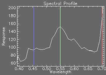
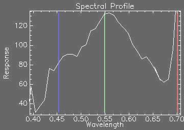
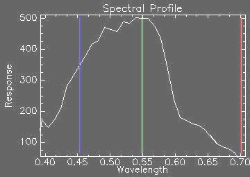
Basic Hyperspectral Analysis Tutorial
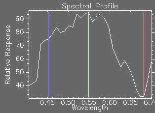
 Basic Hyperspectral Analysis Tutorial This tutorial introduces you to visualization and interactive analysis tools for working with hyperspectral data. In this tutorial, you will: Analyze spectral profiles
An Introduction to Geomatics. Prepared by: Dr. Maher A. El-Hallaq خاص بطلبة مساق مقدمة في علم. Associate Professor of Surveying IUG
 An Introduction to Geomatics خاص بطلبة مساق مقدمة في علم الجيوماتكس Prepared by: Dr. Maher A. El-Hallaq Associate Professor of Surveying IUG 1 Airborne Imagery Dr. Maher A. El-Hallaq Associate Professor
1. Theory of remote sensing and spectrum
 1. Theory of remote sensing and spectrum 7 August 2014 ONUMA Takumi Outline of Presentation Electromagnetic wave and wavelength Sensor type Spectrum Spatial resolution Spectral resolution Mineral mapping
On the use of water color missions for lakes in 2021
 Lakes and Climate: The Role of Remote Sensing June 01-02, 2017 On the use of water color missions for lakes in 2021 Cédric G. Fichot Department of Earth and Environment 1 Overview 1. Past and still-ongoing
Introduction of Satellite Remote Sensing
 Introduction of Satellite Remote Sensing Spatial Resolution (Pixel size) Spectral Resolution (Bands) Resolutions of Remote Sensing 1. Spatial (what area and how detailed) 2. Spectral (what colors bands)
Modeling spectral discrimination of Great Barrier Reef benthic communities by remote sensing instruments
 Limnol. Oceanogr., 48(1, part 2), 2003, 497 510 2003, by the American Society of Limnology and Oceanography, Inc. Modeling spectral discrimination of Great Barrier Reef benthic communities by remote sensing
Sustained Ocean Color Research and Operations
 Sustained Ocean Color Research and Operations What are the minimum requirements to continue the SeaWiFS/MODIS time-series? Based on a National Research Council report by the Ocean Studies Board May 2011
Towards a Management Plan for a Tropical Reef-Lagoon System Using Airborne Multispectral Imaging and GIS
 Towards a Management Plan for a Tropical Reef-Lagoon System Using Airborne Multispectral Imaging and GIS This paper was presented at the Fourth International Conference on Remote Sensing for Marine and
Introduction to Remote Sensing
 Introduction to Remote Sensing Spatial, spectral, temporal resolutions Image display alternatives Vegetation Indices Image classifications Image change detections Accuracy assessment Satellites & Air-Photos
EUSIPCO Worldview-2 High Resolution Remote Sensing Image Processing for the Monitoring of Coastal Areas
 EUSIPCO 2013 1569741167 Worldview-2 High Resolution Remote Sensing Image Processing for the Monitoring of Coastal Areas Francisco Eugenio 1, Javier Martin 1, Javier Marcello 1 and Juan A. Bermejo 2 1 Instituto
Blacksburg, VA July 24 th 30 th, 2010 Remote Sensing Page 1. A condensed overview. For our purposes
 A condensed overview George McLeod Prepared by: With support from: NSF DUE-0903270 in partnership with: Geospatial Technician Education Through Virginia s Community Colleges (GTEVCC) The art and science
ENMAP RADIOMETRIC INFLIGHT CALIBRATION, POST-LAUNCH PRODUCT VALIDATION, AND INSTRUMENT CHARACTERIZATION ACTIVITIES
 ENMAP RADIOMETRIC INFLIGHT CALIBRATION, POST-LAUNCH PRODUCT VALIDATION, AND INSTRUMENT CHARACTERIZATION ACTIVITIES A. Hollstein1, C. Rogass1, K. Segl1, L. Guanter1, M. Bachmann2, T. Storch2, R. Müller2,
SEA GRASS MAPPING FROM SATELLITE DATA
 JSPS National Coordinators Meeting, Coastal Marine Science 19 20 May 2008 Melaka SEA GRASS MAPPING FROM SATELLITE DATA Mohd Ibrahim Seeni Mohd, Nurul Hazrina Idris, Samsudin Ahmad 1. Introduction PRESENTATION
35017 Las Palmas de Gran Canaria, Spain Santa Cruz de Tenerife, Spain ABSTRACT
 Atmospheric correction models for high resolution WorldView-2 multispectral imagery: A case study in Canary Islands, Spain. J. Martin* a F. Eugenio a, J. Marcello a, A. Medina a, Juan A. Bermejo b a Institute
REMOTE SENSING. Topic 10 Fundamentals of Digital Multispectral Remote Sensing MULTISPECTRAL SCANNERS MULTISPECTRAL SCANNERS
 REMOTE SENSING Topic 10 Fundamentals of Digital Multispectral Remote Sensing Chapter 5: Lillesand and Keifer Chapter 6: Avery and Berlin MULTISPECTRAL SCANNERS Record EMR in a number of discrete portions
Spectral Signatures. Vegetation. 40 Soil. Water WAVELENGTH (microns)
") Spectral Signatures % REFLECTANCE VISIBLE NEAR INFRARED Vegetation Soil Water.5. WAVELENGTH (microns). Spectral Reflectance of Urban Materials 5 Parking Lot 5 (5=5%) Reflectance 5 5 5 5 5 Wavelength (nm)
Spectral Signatures % REFLECTANCE VISIBLE NEAR INFRARED Vegetation Soil Water.5. WAVELENGTH (microns). Spectral Reflectance of Urban Materials 5 Parking Lot 5 (5=5%) Reflectance 5 5 5 5 5 Wavelength (nm)
Lecture 6: Multispectral Earth Resource Satellites. The University at Albany Fall 2018 Geography and Planning
 Lecture 6: Multispectral Earth Resource Satellites The University at Albany Fall 2018 Geography and Planning Outline SPOT program and other moderate resolution systems High resolution satellite systems
Remote Sensing and GIS
 Remote Sensing and GIS Atmosphere Reflected radiation, e.g. Visible Emitted radiation, e.g. Infrared Backscattered radiation, e.g. Radar (λ) Visible TIR Radar & Microwave 11/9/2017 Geo327G/386G, U Texas,
Int n r t o r d o u d c u ti t on o n to t o Remote Sensing
 Introduction to Remote Sensing Definition of Remote Sensing Remote sensing refers to the activities of recording/observing/perceiving(sensing)objects or events at far away (remote) places. In remote sensing,
Multispectral Scanners for Wildland Fire Assessment NASA Ames Research Center Earth Science Division. Bruce Coffland U.C.
 Multispectral Scanners for Wildland Fire Assessment NASA Earth Science Division Bruce Coffland U.C. Santa Cruz Slide Fire Burn Area (MASTER/B200) R 2.2um G 0.87um B 0.65um Airborne Science & Technology
typical spectral signatures of photosynthetically active and non-photosynthetically active vegetation (Beeri et al., 2007)
") typical spectral signatures of photosynthetically active and non-photosynthetically active vegetation (Beeri et al., 2007) Xie, Y. et al. J Plant Ecol 2008 1:9-23; doi:10.1093/jpe/rtm005 Copyright restrictions
typical spectral signatures of photosynthetically active and non-photosynthetically active vegetation (Beeri et al., 2007) Xie, Y. et al. J Plant Ecol 2008 1:9-23; doi:10.1093/jpe/rtm005 Copyright restrictions
VICARIOUS CALIBRATION SITE SELECTION FOR RAZAKSAT MEDIUM-SIZED APERTURE CAMERA (MAC)
") VICARIOUS CALIBRATION SITE SELECTION FOR RAZAKSAT MEDIUM-SIZED APERTURE CAMERA (MAC) Lee Yee Hwai a, Mazlan Hashim b, Ahmad Sabirin Arshad a a Astronautic Technology (M) Sdn Bhd (yee_hwai, sabirin)@atsb.com.my
VICARIOUS CALIBRATION SITE SELECTION FOR RAZAKSAT MEDIUM-SIZED APERTURE CAMERA (MAC) Lee Yee Hwai a, Mazlan Hashim b, Ahmad Sabirin Arshad a a Astronautic Technology (M) Sdn Bhd (yee_hwai, sabirin)@atsb.com.my
remote sensing? What are the remote sensing principles behind these Definition
 Introduction to remote sensing: Content (1/2) Definition: photogrammetry and remote sensing (PRS) Radiation sources: solar radiation (passive optical RS) earth emission (passive microwave or thermal infrared
Exploring the Depth Coral Reefs, Mapping and Monitoring
 Exploring the Depth Coral Reefs, Mapping and Monitoring Dr Chris Roelfsema School Of Geography, Planning and Environmental Management Our Aim To introduce you to the world of coral reef monitoring on the
INF-GEO Introduction to remote sensing
 INF-GEO 4310 Introduction to remote sensing Anne Solberg (anne@ifi.uio.no) Satellites, orbits and repeat cycles Optical remote sensings Based on a tutorial adapted from Canadian Center for Remote Sensing,
Introduction to Remote Sensing
 Introduction to Remote Sensing Outline Remote Sensing Defined Resolution Electromagnetic Energy (EMR) Types Interpretation Applications Remote Sensing Defined Remote Sensing is: The art and science of
Application of Soft Classification Algorithm In Increasing Per Class Classification Accuracy Of Coral Habitat. Aidy M Muslim
 Application of Soft Classification Algorithm In Increasing Per Class Classification Accuracy Of Coral Habitat Aidy M Muslim INTRODUCTION Coral reefs play an essential role to our ecosystem and offer the
Wesley J. Moses., Washington, D.C., USA.
 Wesley J. Moses, Washington, D.C., USA. Sensor Characteristics 2 Spatial Resolution Spectral Resolution Signal-to-Noise Ratio Temporal Resolution Spatial Resolution 3 What is the dominant spatial scale
CHARACTERISTICS OF REMOTELY SENSED IMAGERY. Radiometric Resolution
 CHARACTERISTICS OF REMOTELY SENSED IMAGERY Radiometric Resolution There are a number of ways in which images can differ. One set of important differences relate to the various resolutions that images express.
Jeffrey H. Bowles, Wesley J. Moses, Gia M. Lamela, Richard Mied, Karen W. Patterson, and Ellen J. Wagner
 1 Jeffrey H. Bowles, Wesley J. Moses, Gia M. Lamela, Richard Mied, Karen W. Patterson, and Ellen J. Wagner and, Washington, D.C. from Center for Advanced Land Management Information Technologies (CALMIT),
Introduction. Introduction. Introduction. Introduction. Introduction
 Identifying habitat change and conservation threats with satellite imagery Extinction crisis Volker Radeloff Department of Forest Ecology and Management Extinction crisis Extinction crisis Conservationists
Overview of how remote sensing is used by the wildland fire community.
 Overview of how remote sensing is used by the wildland fire community. Presented to the ASEN 6210 Remote Sensing Seminar on 2/18/04 by: Jeff Baranyi ESRI Denver Reported by Gary Fager. Images are from
The Development of Imaging Spectrometry of the Coastal Ocean
 SU_8/2/2006_Davis.1 The Development of Imaging Spectrometry of the Coastal Ocean Curtiss O. Davis College of Oceanic and Atmospheric Sciences, Oregon State University, Corvallis, OR 97331 cdavis@coas.oregonstate.edu
9/12/2011. Training Course Remote Sensing Basic Theory & Image Processing Methods September 2011
 Training Course Remote Sensing Basic Theory & Image Processing Methods 19 23 September 2011 Popular Remote Sensing Sensors & their Selection Michiel Damen (September 2011) damen@itc.nl 1 Overview Low resolution
Sun glint correction of very high spatial resolution images
 Sun glint correction of very high spatial resolution images G. Doxani, M. Papadopoulou, P. Lafazani, M. Tsakiri - Strati, E. Mavridou Department of Cadastre, Photogrammetry and Cartography, Aristotle University
Chapter 8. Remote sensing
 1. Remote sensing 8.1 Introduction 8.2 Remote sensing 8.3 Resolution 8.4 Landsat 8.5 Geostationary satellites GOES 8.1 Introduction What is remote sensing? One can describe remote sensing in different
Lecture 2. Electromagnetic radiation principles. Units, image resolutions.
 NRMT 2270, Photogrammetry/Remote Sensing Lecture 2 Electromagnetic radiation principles. Units, image resolutions. Tomislav Sapic GIS Technologist Faculty of Natural Resources Management Lakehead University
Light penetration within a clear water body. E z = E 0 e -kz
 THE BLUE PLANET 1 2 Light penetration within a clear water body E z = E 0 e -kz 3 4 5 6 Pure Seawater Phytoplankton b w 10-2 m -1 b w 10-2 m -1 b w, Morel (1974) a w, Pope and Fry (1997) b chl,loisel and
Using Norwegian competence from oil and gas subsea operations towards the development of ocean mining operations
 Using Norwegian competence from oil and gas subsea operations towards the development of ocean mining operations Yoshinori Miura, Jens Laugesen, Øyvind Fjukmoen, Lucy Brooks, Karsten Hagenah, Tor Jensen
Remote Sensing Platforms
 Remote Sensing Platforms Remote Sensing Platforms - Introduction Allow observer and/or sensor to be above the target/phenomena of interest Two primary categories Aircraft Spacecraft Each type offers different
APCAS/10/21 April 2010 ASIA AND PACIFIC COMMISSION ON AGRICULTURAL STATISTICS TWENTY-THIRD SESSION. Siem Reap, Cambodia, April 2010
 APCAS/10/21 April 2010 Agenda Item 8 ASIA AND PACIFIC COMMISSION ON AGRICULTURAL STATISTICS TWENTY-THIRD SESSION Siem Reap, Cambodia, 26-30 April 2010 The Use of Remote Sensing for Area Estimation by Robert
Fundamentals of Remote Sensing
 Climate Variability, Hydrology, and Flooding Fundamentals of Remote Sensing May 19-22, 2015 GEO-Latin American & Caribbean Water Cycle Capacity Building Workshop Cartagena, Colombia 1 Objective To provide
Ghazanfar A. Khattak National Centre of Excellence in Geology University of Peshawar
 INTRODUCTION TO REMOTE SENSING Ghazanfar A. Khattak National Centre of Excellence in Geology University of Peshawar WHAT IS REMOTE SENSING? Remote sensing is the science of acquiring information about
Introduction to Remote Sensing. Electromagnetic Energy. Data From Wave Phenomena. Electromagnetic Radiation (EMR) Electromagnetic Energy
 Electromagnetic Energy") A Basic Introduction to Remote Sensing (RS) ~~~~~~~~~~ Rev. Ronald J. Wasowski, C.S.C. Associate Professor of Environmental Science University of Portland Portland, Oregon 1 September 2015 Introduction
A Basic Introduction to Remote Sensing (RS) ~~~~~~~~~~ Rev. Ronald J. Wasowski, C.S.C. Associate Professor of Environmental Science University of Portland Portland, Oregon 1 September 2015 Introduction
ESA UNCLASSIFIED - For Official Use
 ESA UNCLASSIFIED - For Official Use A Hyperspectral Mission for Sentinel-2 Data Product Validation of a Northern Ombrotrophic Bog Soffer R. J., Arroyo-Mora J.P., Kalacska M., White, H.P., Ifimov G., Leblanc
Satellite/Aircraft Imaging Systems Imaging Sensors Standard scanner designs Image data formats
 CEE 6150: Digital Image Processing 1 Satellite/Aircraft Imaging Systems Imaging Sensors Standard scanner designs Image data formats CEE 6150: Digital Image Processing 2 CEE 6150: Digital Image Processing
Hyperspectral Imaging of the Coastal Ocean
 Hyperspectral Imaging of the Coastal Ocean Curtiss O. Davis College of Oceanic and Atmospheric Sciences, 04 COAS Admin, Bldg., Corvallis, OR 9733 phone: (54) 737-5707 fax: (54) 737-2064 email: cdavis@coas.oregonstate.edu
GOCI Status and Cooperation with CoastColour Project
 GOCI Status and Cooperation with CoastColour Project Joo-Hyung RYU Contribution from : KOSC colleaques Nov. 17, 2010 World 1 st GOCI/COMS Launch Campaign Launch Date : June 27 2010 Launch Vehicle : Ariane-V
RADAR (RAdio Detection And Ranging)
") RADAR (RAdio Detection And Ranging) CLASSIFICATION OF NONPHOTOGRAPHIC REMOTE SENSORS PASSIVE ACTIVE DIGITAL CAMERA THERMAL (e.g. TIMS) VIDEO CAMERA MULTI- SPECTRAL SCANNERS VISIBLE & NIR MICROWAVE Real
RADAR (RAdio Detection And Ranging) CLASSIFICATION OF NONPHOTOGRAPHIC REMOTE SENSORS PASSIVE ACTIVE DIGITAL CAMERA THERMAL (e.g. TIMS) VIDEO CAMERA MULTI- SPECTRAL SCANNERS VISIBLE & NIR MICROWAVE Real
NORMALIZING ASTER DATA USING MODIS PRODUCTS FOR LAND COVER CLASSIFICATION
 NORMALIZING ASTER DATA USING MODIS PRODUCTS FOR LAND COVER CLASSIFICATION F. Gao a, b, *, J. G. Masek a a Biospheric Sciences Branch, NASA Goddard Space Flight Center, Greenbelt, MD 20771, USA b Earth
Eos,Vol. 85, No. 31, 3 August 2004
 Eos,Vol. 85, No. 31, 3 August 2004 Fig. I. The Seabed AUV (top left) has been designed for high-resolution imaging close to the sea floor. It is capable of working very close to the sea floor, as illustrated
MULTISPECTRAL IMAGE PROCESSING I
 TM1 TM2 337 TM3 TM4 TM5 TM6 Dr. Robert A. Schowengerdt TM7 Landsat Thematic Mapper (TM) multispectral images of desert and agriculture near Yuma, Arizona MULTISPECTRAL IMAGE PROCESSING I SENSORS Multispectral
GIS Data Collection. Remote Sensing
 GIS Data Collection Remote Sensing Data Collection Remote sensing Introduction Concepts Spectral signatures Resolutions: spectral, spatial, temporal Digital image processing (classification) Other systems
The Study of Sea Bottom Morphology and Bathymetric Mapping Using Worldview-2 Imagery
 The Study of Sea Bottom Morphology and Bathymetric Mapping Using Worldview-2 Imagery Iwan E. Setiawan Badan Informasi Geospasial, Cibinong, Indonesia Doddy M. Yuwono Badan Informasi Geospasial, Cibinong,
MUSKY: Multispectral UV Sky camera. Valentina Caricato, Andrea Egidi, Marco Pisani and Massimo Zucco, INRIM
 MUSKY: Multispectral UV Sky camera Valentina Caricato, Andrea Egidi, Marco Pisani and Massimo Zucco, INRIM Outline Purpose of the instrument Required specs Hyperspectral or multispectral? Optical design
Remote Sensing for Rangeland Applications
 Remote Sensing for Rangeland Applications Jay Angerer Ecological Training June 16, 2012 Remote Sensing The term "remote sensing," first used in the United States in the 1950s by Ms. Evelyn Pruitt of the
Remote Sensing. Ch. 3 Microwaves (Part 1 of 2)
") Remote Sensing Ch. 3 Microwaves (Part 1 of 2) 3.1 Introduction 3.2 Radar Basics 3.3 Viewing Geometry and Spatial Resolution 3.4 Radar Image Distortions 3.1 Introduction Microwave (1cm to 1m in wavelength)
Remote Sensing Ch. 3 Microwaves (Part 1 of 2) 3.1 Introduction 3.2 Radar Basics 3.3 Viewing Geometry and Spatial Resolution 3.4 Radar Image Distortions 3.1 Introduction Microwave (1cm to 1m in wavelength)
SATELLITE OCEANOGRAPHY
 SATELLITE OCEANOGRAPHY An Introduction for Oceanographers and Remote-sensing Scientists I. S. Robinson Lecturer in Physical Oceanography Department of Oceanography University of Southampton JOHN WILEY
Ozobot Bit. Computer Science Engineering Program
 3 rd Grade Ozobot Bit Computer Science Engineering Program Post Visit Activity Resources 2018 Winter/Spring 2018 Dear Third Grade Visiting Classroom Teacher, It is hoped that you and your students enjoyed
Evaluation of Underwater Spectral Data for Colour Correction Applications
 Proceedings of the 5th WSEAS Int. Conf. on CIRCUITS, SYSTEMS, ELECTRONICS, CONTROL & SIGNAL PROCESSING, Dallas, USA, November 1-3, 2006 321 Evaluation of Underwater Spectral Data for Colour Correction
EnMAP Environmental Mapping and Analysis Program
 EnMAP Environmental Mapping and Analysis Program www.enmap.org Mathias Schneider Mission Objectives Regular provision of high-quality calibrated hyperspectral data Precise measurement of ecosystem parameters
The studies began when the Tiros satellites (1960) provided man s first synoptic view of the Earth s weather systems.
 provided man s first synoptic view of the Earth s weather systems.") Remote sensing of the Earth from orbital altitudes was recognized in the mid-1960 s as a potential technique for obtaining information important for the effective use and conservation of natural resources.
Remote sensing of the Earth from orbital altitudes was recognized in the mid-1960 s as a potential technique for obtaining information important for the effective use and conservation of natural resources.
Lecture 13: Remotely Sensed Geospatial Data
 Lecture 13: Remotely Sensed Geospatial Data A. The Electromagnetic Spectrum: The electromagnetic spectrum (Figure 1) indicates the different forms of radiation (or simply stated light) emitted by nature.
Present and future of marine production in Boka Kotorska
 Present and future of marine production in Boka Kotorska First results from satellite remote sensing for the breeding areas of filter feeders in the Bay of Kotor INTRODUCTION Environmental monitoring is
Railroad Valley Playa for use in vicarious calibration of large footprint sensors
 Railroad Valley Playa for use in vicarious calibration of large footprint sensors K. Thome, J. Czapla-Myers, S. Biggar Remote Sensing Group Optical Sciences Center University of Arizona Introduction P
Application of Satellite Image Processing to Earth Resistivity Map
 Application of Satellite Image Processing to Earth Resistivity Map KWANCHAI NORSANGSRI and THANATCHAI KULWORAWANICHPONG Power System Research Unit School of Electrical Engineering Suranaree University
Module 3 Introduction to GIS. Lecture 8 GIS data acquisition
 Module 3 Introduction to GIS Lecture 8 GIS data acquisition GIS workflow Data acquisition (geospatial data input) GPS Remote sensing (satellites, UAV s) LiDAR Digitized maps Attribute Data Management Data
High Resolution Multi-spectral Imagery
 High Resolution Multi-spectral Imagery Jim Baily, AirAgronomics AIRAGRONOMICS Having been involved in broadacre agriculture until 2000 I perceived a need for a high resolution remote sensing service to
Remote sensing in archaeology from optical to lidar. Krištof Oštir ModeLTER Scientific Research Centre of the Slovenian Academy of Sciences and Arts
 Remote sensing in archaeology from optical to lidar Krištof Oštir ModeLTER Scientific Research Centre of the Slovenian Academy of Sciences and Arts Introduction Optical remote sensing Systems Search for
Evaluation of FLAASH atmospheric correction. Note. Note no SAMBA/10/12. Authors. Øystein Rudjord and Øivind Due Trier
 Evaluation of FLAASH atmospheric correction Note Note no Authors SAMBA/10/12 Øystein Rudjord and Øivind Due Trier Date 16 February 2012 Norsk Regnesentral Norsk Regnesentral (Norwegian Computing Center,
Lecture 7 Earth observation missions
 Remote sensing for agricultural applications: principles and methods (2013-2014) Instructor: Prof. Tao Cheng (tcheng@njau.edu.cn). Nanjing Agricultural University Lecture 7 Earth observation missions May
Microwave Remote Sensing (1)
") Microwave Remote Sensing (1) Microwave sensing encompasses both active and passive forms of remote sensing. The microwave portion of the spectrum covers the range from approximately 1cm to 1m in wavelength.
Microwave Remote Sensing (1) Microwave sensing encompasses both active and passive forms of remote sensing. The microwave portion of the spectrum covers the range from approximately 1cm to 1m in wavelength.
John P. Stevens HS: Remote Sensing Test
 Name(s): Date: Team name: John P. Stevens HS: Remote Sensing Test 1 Scoring: Part I - /18 Part II - /40 Part III - /16 Part IV - /14 Part V - /93 Total: /181 2 I. History (3 pts. each) 1. What is the name
MERIS instrument. Muriel Simon, Serco c/o ESA
 MERIS instrument Muriel Simon, Serco c/o ESA Workshop on Sustainable Development in Mountain Areas of Andean Countries Mendoza, Argentina, 26-30 November 2007 ENVISAT MISSION 2 Mission Chlorophyll case
Evaluation of Sentinel-2 bands over the spectrum
 Evaluation of Sentinel-2 bands over the spectrum S.E. Hosseini Aria, M. Menenti, Geoscience and Remote sensing Department Delft University of Technology, Netherlands 1 outline ointroduction - Concept odata