Satellite/Aircraft Imaging Systems Imaging Sensors Standard scanner designs Image data formats
|
|
|
- Ginger Morgan
- 5 years ago
- Views:
Transcription
1 CEE 6150: Digital Image Processing 1 Satellite/Aircraft Imaging Systems Imaging Sensors Standard scanner designs Image data formats
2 CEE 6150: Digital Image Processing 2

3 CEE 6150: Digital Image Processing 3


4 CEE 6150: Digital Image Processing 4 Typical whiskbroom scanner geometry Scanning design to improve dwell time: whiskbroom scanners Banding from Whiskbroom Scanner Differences in calibration of individual detectors Differences in calibration associated with scan direction

5 CEE 6150: Digital Image Processing 5 Spectral Band Selection: Landsat 5 (TM) and Landsat 7 (ETM+) TM Focal Plane Array
 (Since 1986) Mode Spectral Band Res. Multispectral (XS) SPOT 1,2,3,4,5 1 (Green) 0.50-0.")
 SPOT 1,2,3 0.51-0.73 µm 10 m SPOT 4 0.61-0.68 µm 10 m SPOT 5 0.48-0.68 µm 2.")

6 CEE 6150: Digital Image Processing 6 PUSHBROOM SCANNERS: Scanner geometry: SPOT Spatial Resolution (SPOT) (Since 1986) Mode Spectral Band Res. Multispectral (XS) SPOT 1,2,3,4,5 1 (Green) µm 20 m 2 (Red) µm 20 m 3 (Near IR) µm 20 m SPOT 4,5 4 (Mid IR) µm 20 m Panchromatic (P) SPOT 1,2, µm 10 m SPOT µm 10 m SPOT µm 2.5 m* Swath nadir: 60 km * The panchromatic band uses two 5 m sample arrays offset by 2.5 m in both the cross-track and along-track directions. This results in a quasi-2.5 m sample spacing, but with a resolution cell size of 5 m.
7 CEE 6150: Digital Image Processing 7 IKONOS (Space Imaging) Multispectral spatial dynamic Band Spectral Range (FWHM) Res. range nm (Blue) 4 m 11 bits nm (Green) 4 m nm (Red) 4 m nm (NIR) 4 m Panchromatic spatial dynamic Spectral Range (FWHM) Res. range nm (Blue) 1 m 11 bits swath nadir: 10 km Spectral Band Selection: QuickBird Multispectral spatial dynamic Band Spectral Range (FWHM) Res. range nm (Blue) 2.44 m 11 bits nm (Green) 2.44 m 11 bits nm (Red) 2.44 m 11 bits nm (NIR) 2.44 m 11 bits Panchromatic spatial dynamic Spectral Range (FWHM) Res. range nm (Blue) 0.61 m 11 bits swath nadir: 16.5 km Spectral Band Selection: WorldView-2 Multispectral nadir dynamic Band Spectral Range (FWHM) Res. range nm (Coastal) 1.84 m 11 bits nm (Blue) 1.84 m 11 bits nm (Green) 1.84 m 11 bits nm (Yellow) 1.84 m 11 bits nm (Red) 1.84 m 11 bits nm (Red Edge) 1.84 m 11 bits nm (NIR 1) 1.84 m 11 bits nm (NIR 2) 1.84 m 11 bits off-nadir Panchromatic nm (Panchromatic) 0.46 m 11 bits swath nadir: 16.4 km off-nadir Operational Land Imager (OLI; Landsat 8) Spectral bands: Focal plane array: balticbloom_oli_ _lrg.jpg Web Resources Satellite Imaging Corporation: High resolution commercial systems; system descriptions and access to imagery (for purchase). U.S. Government image data: Access to imagery (free, mostly); includes data descriptions


8 CEE 6150: Digital Image Processing 8 System Specs: AVIRIS (Visible-IR Imaging Spectrometer (AVIRIS) Data Rate: 17 Mbps through 1994, 20.4 Mbps from Bit depth: 10 bit through 1994, 12 bit from Detectors: Silicon (Si) for the visible range, indium-antimonide (InSb) for the NIR Scanning: "Whisk broom", 12 Hz scanning rate Spectral: 10 nm bandwidth, µm (224 bands) 20 km: 30 m GIFOV Color Pixel misregistration (design dependent) Color pixels along the edge of the road are due to nearestneighbor resampling of different spectral bands when the color registration is imperfect. 2-D CCD arrays folding mirror (static) diffraction grating 2-D array Scanner geometry: Hyperspectral flight path IFOV θ H H sec θ ω
 is placed between the lens and the sensors.")
, for the filter elements arranged in a 2x2")
 lens, 2) low pass filters, 3) array Higher degree of randomness with")

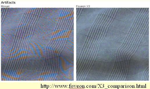
9 CEE 6150: Digital Image Processing 9 Color Representation in Digital Cameras Bayer Pattern Digital Cameras have only one 2-D array A color filter array (CFA) is placed between the lens and the sensors. A CFA typically has one color filter element for each sensor. The Bayer pattern uses the three additive primary colors, red, green and blue (RGB), for the filter elements arranged in a 2x2 pattern.. Fuji X-trans color array (new) 1) lens, 2) low pass filters, 3) array Higher degree of randomness with an array of 6 x 6 pixel units. Without using an optical low-pass filter, moire and false colors are minimized while retaining high resolution. Inspired by the natural random arrangement of the fine grains of silver halide in film. Fovean camerathe layers of silicon take advantage of the fact that silicon absorbs different colors of light at different depths, so one layer records red, another layer records green and the other layer records blue.


10 CEE 6150: Digital Image Processing 10
11 CEE 6150: Digital Image Processing 11 Orbital Mechanics The orbital speed of a body, in our case, a satellite, is the speed at which it orbits around the earth. Here, for simplicity, we consider only circular orbits and Newton's laws (nothing about energy or momentum). We further assume that only two objects (the earth and the satellite) need to be considered and that the mass of the satellite is negligible relative to the mass of the earth. In this case, the centripetal force, Fc, acting to drive the satellite away from the earth, and the gravitational force, Fg, attracting the satellite toward the earth, must balance exactly. Thus, if ms is the mass of the satellite, me, is the mass of the earth, G is the universal gravitational constant, and r is the distance from the center of the earth to the satellite, then: F c 2 s Gmsme ; Fg 2 = m v r = Gm v = e r r where r = re + h (the radius of the earth + the altitude of the satellite). An object moving faster than circular velocity will enter an elliptical orbit with a velocity at any point determined by Kepler's laws of planetary motion. If the object moves faster still, it will travel at escape velocity along a parabolic orbit or beyond escape velocity in a hyperbolic orbit. Orbital Period The orbital period T = 2π 3 r Gm e of a small body orbiting a central body in a circular or elliptical orbit is: The radium of the earth, re=6.378x10 6 m The standard gravitational parameter, μ = Gme=3.986x10 14 m 3 s -2 Orbital families LEO: low earth orbit, typical altitude < 2000 km o space shuttle o space station o Hubble Space Telescope o iridium o remote sensing: EROS, Landsat o communications: , text messaging, paging MEO: medium earth orbit, typical altitude 10,000 to 20,000 km o GPS: Global Positioning System GEO: geosynchronous earth orbit, seven earth radii, one-ninth of the distance to the moon, altitude = 36,000 km o GOES - Geosynchronous (Geostationary) Operational Environmental Satellites o communication: signal relays for terrestrial broadcast and cable systems direct broadcast satellite TV and radio o TDRS: Tracking and Data Relay Satellite
Philpot & Philipson: Remote Sensing Fundamentals Scanners 8.1 W.D. Philpot, Cornell University, Fall 2015
 Philpot & Philipson: Remote Sensing Fundamentals Scanners 8.1 8. SCANNERS 8.1 General Scanners are scanning radiometers which, when operated from an airborne or spaceborne platform, image the terrain in
NON-PHOTOGRAPHIC SYSTEMS: Multispectral Scanners Medium and coarse resolution sensor comparisons: Landsat, SPOT, AVHRR and MODIS
 NON-PHOTOGRAPHIC SYSTEMS: Multispectral Scanners Medium and coarse resolution sensor comparisons: Landsat, SPOT, AVHRR and MODIS CLASSIFICATION OF NONPHOTOGRAPHIC REMOTE SENSORS PASSIVE ACTIVE DIGITAL
746A27 Remote Sensing and GIS. Multi spectral, thermal and hyper spectral sensing and usage
 746A27 Remote Sensing and GIS Lecture 3 Multi spectral, thermal and hyper spectral sensing and usage Chandan Roy Guest Lecturer Department of Computer and Information Science Linköping University Multi
The studies began when the Tiros satellites (1960) provided man s first synoptic view of the Earth s weather systems.
 provided man s first synoptic view of the Earth s weather systems.") Remote sensing of the Earth from orbital altitudes was recognized in the mid-1960 s as a potential technique for obtaining information important for the effective use and conservation of natural resources.
Remote sensing of the Earth from orbital altitudes was recognized in the mid-1960 s as a potential technique for obtaining information important for the effective use and conservation of natural resources.
Some Basic Concepts of Remote Sensing. Lecture 2 August 31, 2005
 Some Basic Concepts of Remote Sensing Lecture 2 August 31, 2005 What is remote sensing Remote Sensing: remote sensing is science of acquiring, processing, and interpreting images and related data that
Consumer digital CCD cameras
 CAMERAS Consumer digital CCD cameras Leica RC-30 Aerial Cameras Zeiss RMK Zeiss RMK in aircraft Vexcel UltraCam Digital (note multiple apertures Lenses for Leica RC-30. Many elements needed to minimize
Remote Sensing Platforms
 Types of Platforms Lighter-than-air Remote Sensing Platforms Free floating balloons Restricted by atmospheric conditions Used to acquire meteorological/atmospheric data Blimps/dirigibles Major role - news
US Commercial Imaging Satellites
 US Commercial Imaging Satellites In the early 1990s, Russia began selling 2-meter resolution product from its archives of collected spy satellite imagery. Some of this product was down-sampled to provide
IKONOS High Resolution Multispectral Scanner Sensor Characteristics
 High Spatial Resolution and Hyperspectral Scanners IKONOS High Resolution Multispectral Scanner Sensor Characteristics Launch Date View Angle Orbit 24 September 1999 Vandenberg Air Force Base, California,
Lecture 6: Multispectral Earth Resource Satellites. The University at Albany Fall 2018 Geography and Planning
 Lecture 6: Multispectral Earth Resource Satellites The University at Albany Fall 2018 Geography and Planning Outline SPOT program and other moderate resolution systems High resolution satellite systems
Outline. Introduction. Introduction: Film Emulsions. Sensor Systems. Types of Remote Sensing. A/Prof Linlin Ge. Photographic systems (cf(
 GMAT x600 Remote Sensing / Earth Observation Types of Sensor Systems (1) Outline Image Sensor Systems (i) Line Scanning Sensor Systems (passive) (ii) Array Sensor Systems (passive) (iii) Antenna Radar
Remote Sensing Platforms
 Remote Sensing Platforms Remote Sensing Platforms - Introduction Allow observer and/or sensor to be above the target/phenomena of interest Two primary categories Aircraft Spacecraft Each type offers different
Introduction to Remote Sensing. Electromagnetic Energy. Data From Wave Phenomena. Electromagnetic Radiation (EMR) Electromagnetic Energy
 Electromagnetic Energy") A Basic Introduction to Remote Sensing (RS) ~~~~~~~~~~ Rev. Ronald J. Wasowski, C.S.C. Associate Professor of Environmental Science University of Portland Portland, Oregon 1 September 2015 Introduction
A Basic Introduction to Remote Sensing (RS) ~~~~~~~~~~ Rev. Ronald J. Wasowski, C.S.C. Associate Professor of Environmental Science University of Portland Portland, Oregon 1 September 2015 Introduction
Aral Sea profile Selection of area 24 February April May 1998
 250 km Aral Sea profile 1960 1960 1985 1986 1987 1988 1989 1990 1991 1992 1993 1994 1995 1996 1997 1998 2010? Selection of area Area of interest Kzyl-Orda Dried seabed 185 km Syrdarya river Aral Sea Salt
An Introduction to Geomatics. Prepared by: Dr. Maher A. El-Hallaq خاص بطلبة مساق مقدمة في علم. Associate Professor of Surveying IUG
 An Introduction to Geomatics خاص بطلبة مساق مقدمة في علم الجيوماتكس Prepared by: Dr. Maher A. El-Hallaq Associate Professor of Surveying IUG 1 Airborne Imagery Dr. Maher A. El-Hallaq Associate Professor
CHARACTERISTICS OF REMOTELY SENSED IMAGERY. Spatial Resolution
 CHARACTERISTICS OF REMOTELY SENSED IMAGERY Spatial Resolution There are a number of ways in which images can differ. One set of important differences relate to the various resolutions that images express.
Introduction to Remote Sensing Fundamentals of Satellite Remote Sensing. Mads Olander Rasmussen
 Introduction to Remote Sensing Fundamentals of Satellite Remote Sensing Mads Olander Rasmussen (mora@dhi-gras.com) 01. Introduction to Remote Sensing DHI What is remote sensing? the art, science, and technology
Camera Case Study: HiSCI à now CaSSIS (Colour and Stereo Surface Imaging System)
") Camera Case Study: HiSCI à now CaSSIS (Colour and Stereo Surface Imaging System) A camera for ESA s 2016 ExoMars Trace Gas Orbiter: h
Camera Case Study: HiSCI à now CaSSIS (Colour and Stereo Surface Imaging System) A camera for ESA s 2016 ExoMars Trace Gas Orbiter: h
On the use of water color missions for lakes in 2021
 Lakes and Climate: The Role of Remote Sensing June 01-02, 2017 On the use of water color missions for lakes in 2021 Cédric G. Fichot Department of Earth and Environment 1 Overview 1. Past and still-ongoing
An Introduction to Remote Sensing & GIS. Introduction
 An Introduction to Remote Sensing & GIS Introduction Remote sensing is the measurement of object properties on Earth s surface using data acquired from aircraft and satellites. It attempts to measure something
1 W. Philpot, Cornell University The Digital Image
 1 The Digital Image DEFINITION: A grayscale image is a single-valued function of 2 variables: ff(xx 1, xx 2 ). Notes: A gray scale image is a single-valued function of two spatial variables, ff(xx 11,
REMOTE SENSING. Topic 10 Fundamentals of Digital Multispectral Remote Sensing MULTISPECTRAL SCANNERS MULTISPECTRAL SCANNERS
 REMOTE SENSING Topic 10 Fundamentals of Digital Multispectral Remote Sensing Chapter 5: Lillesand and Keifer Chapter 6: Avery and Berlin MULTISPECTRAL SCANNERS Record EMR in a number of discrete portions
9/12/2011. Training Course Remote Sensing Basic Theory & Image Processing Methods September 2011
 Training Course Remote Sensing Basic Theory & Image Processing Methods 19 23 September 2011 Remote Sensing Platforms Michiel Damen (September 2011) damen@itc.nl 1 Overview Platforms & missions aerial surveys
Lecture Notes Prepared by Prof. J. Francis Spring Remote Sensing Instruments
 Lecture Notes Prepared by Prof. J. Francis Spring 2005 Remote Sensing Instruments Material from Remote Sensing Instrumentation in Weather Satellites: Systems, Data, and Environmental Applications by Rao,
Image Fusion. Pan Sharpening. Pan Sharpening. Pan Sharpening: ENVI. Multi-spectral and PAN. Magsud Mehdiyev Geoinfomatics Center, AIT
 1 Image Fusion Sensor Merging Magsud Mehdiyev Geoinfomatics Center, AIT Image Fusion is a combination of two or more different images to form a new image by using certain algorithms. ( Pohl et al 1998)
Sources of Geographic Information
 Sources of Geographic Information Data properties: Spatial data, i.e. data that are associated with geographic locations Data format: digital (analog data for traditional paper maps) Data Inputs: sampled
Spectral Signatures. Vegetation. 40 Soil. Water WAVELENGTH (microns)
") Spectral Signatures % REFLECTANCE VISIBLE NEAR INFRARED Vegetation Soil Water.5. WAVELENGTH (microns). Spectral Reflectance of Urban Materials 5 Parking Lot 5 (5=5%) Reflectance 5 5 5 5 5 Wavelength (nm)
Spectral Signatures % REFLECTANCE VISIBLE NEAR INFRARED Vegetation Soil Water.5. WAVELENGTH (microns). Spectral Reflectance of Urban Materials 5 Parking Lot 5 (5=5%) Reflectance 5 5 5 5 5 Wavelength (nm)
Introduction of Satellite Remote Sensing
 Introduction of Satellite Remote Sensing Spatial Resolution (Pixel size) Spectral Resolution (Bands) Resolutions of Remote Sensing 1. Spatial (what area and how detailed) 2. Spectral (what colors bands)
GEOMETRIC RECTIFICATION OF EUROPEAN HISTORICAL ARCHIVES OF LANDSAT 1-3 MSS IMAGERY
 GEOMETRIC RECTIFICATION OF EUROPEAN HISTORICAL ARCHIVES OF LANDSAT -3 MSS IMAGERY Torbjörn Westin Satellus AB P.O.Box 427, SE-74 Solna, Sweden tw@ssc.se KEYWORDS: Landsat, MSS, rectification, orbital model
Compact High Resolution Imaging Spectrometer (CHRIS) siraelectro-optics
 siraelectro-optics") Compact High Resolution Imaging Spectrometer (CHRIS) Mike Cutter (Mike_Cutter@siraeo.co.uk) Summary CHRIS Instrument Design Instrument Specification & Performance Operating Modes Calibration Plan Data
Compact High Resolution Imaging Spectrometer (CHRIS) Mike Cutter (Mike_Cutter@siraeo.co.uk) Summary CHRIS Instrument Design Instrument Specification & Performance Operating Modes Calibration Plan Data
The studies began when the Tiros satellites (1960) provided man s first synoptic view of the Earth s weather systems.
 provided man s first synoptic view of the Earth s weather systems.") Remote sensing of the Earth from orbital altitudes was recognized in the mid-1960 s as a potential technique for obtaining information important for the effective use and conservation of natural resources.
Remote sensing of the Earth from orbital altitudes was recognized in the mid-1960 s as a potential technique for obtaining information important for the effective use and conservation of natural resources.
FLIGHT SUMMARY REPORT
 FLIGHT SUMMARY REPORT Flight Number: 97-011 Calendar/Julian Date: 23 October 1996 297 Sensor Package: Area(s) Covered: Wild-Heerbrugg RC-10 Airborne Visible and Infrared Imaging Spectrometer (AVIRIS) Southern
Remote Sensing of the Environment An Earth Resource Perspective John R. Jensen Second Edition
 Remote Sensing of the Environment An Earth Resource Perspective John R. Jensen Second Edition Pearson Education Limited Edinburgh Gate Harlow Essex CM20 2JE England and Associated Companies throughout
Atmospheric interactions; Aerial Photography; Imaging systems; Intro to Spectroscopy Week #3: September 12, 2018
 GEOL 1460/2461 Ramsey Introduction/Advanced Remote Sensing Fall, 2018 Atmospheric interactions; Aerial Photography; Imaging systems; Intro to Spectroscopy Week #3: September 12, 2018 I. Quick Review from
Int n r t o r d o u d c u ti t on o n to t o Remote Sensing
 Introduction to Remote Sensing Definition of Remote Sensing Remote sensing refers to the activities of recording/observing/perceiving(sensing)objects or events at far away (remote) places. In remote sensing,
Lecture 2. Electromagnetic radiation principles. Units, image resolutions.
 NRMT 2270, Photogrammetry/Remote Sensing Lecture 2 Electromagnetic radiation principles. Units, image resolutions. Tomislav Sapic GIS Technologist Faculty of Natural Resources Management Lakehead University
Chapter 3. Data Acquisition Systems. Ayman F. Habib. Remote Sensing
 Chapter 3 Data Acquisition Systems 1 Overview Utilized portions of the electro-magnetic radiation. Visible band. Infrared band. LIDAR systems. Microwave band (RADAR). Optical sensors (scanning operational
Remote Sensing 1 Principles of visible and radar remote sensing & sensors
 Remote Sensing 1 Principles of visible and radar remote sensing & sensors Nick Barrand School of Geography, Earth & Environmental Sciences University of Birmingham, UK Field glaciologist collecting data
9/12/2011. Training Course Remote Sensing Basic Theory & Image Processing Methods September 2011
 Training Course Remote Sensing Basic Theory & Image Processing Methods 19 23 September 2011 Popular Remote Sensing Sensors & their Selection Michiel Damen (September 2011) damen@itc.nl 1 Overview Low resolution
Introduction to Remote Sensing
 Introduction to Remote Sensing Spatial, spectral, temporal resolutions Image display alternatives Vegetation Indices Image classifications Image change detections Accuracy assessment Satellites & Air-Photos
CHAPTER 7: Multispectral Remote Sensing
 CHAPTER 7: Multispectral Remote Sensing REFERENCE: Remote Sensing of the Environment John R. Jensen (2007) Second Edition Pearson Prentice Hall Overview of How Digital Remotely Sensed Data are Transformed
REMOTE SENSING INTERPRETATION
 REMOTE SENSING INTERPRETATION Jan Clevers Centre for Geo-Information - WU Remote Sensing --> RS Sensor at a distance EARTH OBSERVATION EM energy Earth RS is a tool; one of the sources of information! 1
Chapters 1-3. Chapter 1: Introduction and applications of photogrammetry Chapter 2: Electro-magnetic radiation. Chapter 3: Basic optics
 Chapters 1-3 Chapter 1: Introduction and applications of photogrammetry Chapter 2: Electro-magnetic radiation Radiation sources Classification of remote sensing systems (passive & active) Electromagnetic
Japanese Advanced Meteorological Imager: A Next Generation GEO Imager for MTSAT-1R
 Japanese Advanced Meteorological Imager: A Next Generation GEO Imager for MTSAT-1R Jeffery J. Puschell 1 Raytheon Electronic Systems, Santa Barbara Remote Sensing ABSTRACT The Japanese Advanced Meteorological
CHARACTERISTICS OF VERY HIGH RESOLUTION OPTICAL SATELLITES FOR TOPOGRAPHIC MAPPING
 CHARACTERISTICS OF VERY HIGH RESOLUTION OPTICAL SATELLITES FOR TOPOGRAPHIC MAPPING K. Jacobsen Leibniz University Hannover, Institute of Photogrammetry and Geoinformation jacobsen@ipi.uni-hannover.de Commission
Chapter 8. Remote sensing
 1. Remote sensing 8.1 Introduction 8.2 Remote sensing 8.3 Resolution 8.4 Landsat 8.5 Geostationary satellites GOES 8.1 Introduction What is remote sensing? One can describe remote sensing in different
remote sensing? What are the remote sensing principles behind these Definition
 Introduction to remote sensing: Content (1/2) Definition: photogrammetry and remote sensing (PRS) Radiation sources: solar radiation (passive optical RS) earth emission (passive microwave or thermal infrared
WorldView-2. WorldView-2 Overview
 WorldView-2 WorldView-2 Overview 6/4/09 DigitalGlobe Proprietary 1 Most Advanced Satellite Constellation Finest available resolution showing crisp detail Greatest collection capacity Highest geolocation
Abstract Quickbird Vs Aerial photos in identifying man-made objects
 Abstract Quickbird Vs Aerial s in identifying man-made objects Abdullah Mah abdullah.mah@aramco.com Remote Sensing Group, emap Division Integrated Solutions Services Department (ISSD) Saudi Aramco, Dhahran
Hyper-spectral, UHD imaging NANO-SAT formations or HAPS to detect, identify, geolocate and track; CBRN gases, fuel vapors and other substances
 Hyper-spectral, UHD imaging NANO-SAT formations or HAPS to detect, identify, geolocate and track; CBRN gases, fuel vapors and other substances Arnold Kravitz 8/3/2018 Patent Pending US/62544811 1 HSI and
9/22/08. Satellite Systems. History of satellite communication. Applications. History Basics Localization Handover Routing Systems
 Satellite Systems History Basics Localization Handover Routing Systems History of satellite communication 1945 Arthur C. Clarke publishes an essay about Extra Terrestrial Relays 1957 first satellite SPUTNIK
Radiometric Use of WorldView-3 Imagery. Technical Note. 1 WorldView-3 Instrument. 1.1 WorldView-3 Relative Radiance Response
 Radiometric Use of WorldView-3 Imagery Technical Note Date: 2016-02-22 Prepared by: Michele Kuester This technical note discusses the radiometric use of WorldView-3 imagery. The first two sections briefly
Module 3 Introduction to GIS. Lecture 8 GIS data acquisition
 Module 3 Introduction to GIS Lecture 8 GIS data acquisition GIS workflow Data acquisition (geospatial data input) GPS Remote sensing (satellites, UAV s) LiDAR Digitized maps Attribute Data Management Data
A CubeSat-Based Optical Communication Network for Low Earth Orbit
 A CubeSat-Based Optical Communication Network for Low Earth Orbit Richard Welle, Alexander Utter, Todd Rose, Jerry Fuller, Kristin Gates, Benjamin Oakes, and Siegfried Janson The Aerospace Corporation
Introduction to Remote Sensing
 Introduction to Remote Sensing Outline Remote Sensing Defined Resolution Electromagnetic Energy (EMR) Types Interpretation Applications Remote Sensing Defined Remote Sensing is: The art and science of
9/12/2011. Training Course Remote Sensing Basic Theory & Image Processing Methods September 2011
 Training Course Remote Sensing Basic Theory & Image Processing Methods 19 23 September 2011 Introduction to Remote Sensing Michiel Damen (September 2011) damen@itc.nl 1 Overview Some definitions Remote
Earth s Gravitational Pull
 Satellite & Sensors Space Countries Earth s Gravitational Pull The Earth's gravity pulls everything toward the Earth. In order to orbit the Earth, the velocity of a body must be great enough to overcome
1. Theory of remote sensing and spectrum
 1. Theory of remote sensing and spectrum 7 August 2014 ONUMA Takumi Outline of Presentation Electromagnetic wave and wavelength Sensor type Spectrum Spatial resolution Spectral resolution Mineral mapping
Chapters 1-3. Chapter 1: Introduction and applications of photogrammetry Chapter 2: Electro-magnetic radiation. Chapter 3: Basic optics
 Chapters 1-3 Chapter 1: Introduction and applications of photogrammetry Chapter 2: Electro-magnetic radiation Radiation sources Classification of remote sensing systems (passive & active) Electromagnetic
Sentinel-2 Products and Algorithms
 Sentinel-2 Products and Algorithms Ferran Gascon (Sentinel-2 Data Quality Manager) Workshop Preparations for Sentinel 2 in Europe, Oslo 26 November 2014 Sentinel-2 Mission Mission Overview Products and
Detectors that cover a dynamic range of more than 1 million in several dimensions
 Detectors that cover a dynamic range of more than 1 million in several dimensions Detectors for Astronomy Workshop Garching, Germany 10 October 2009 James W. Beletic Teledyne Providing the best images
INF-GEO Introduction to remote sensing. Anne Solberg
 INF-GEO 4310 Introduction to remote sensing Anne Solberg (anne@ifi.uio.no) Satellites, orbits and repeat cycles Optical remote sensing Useful links: Glossary for remote sensing terms: http://www.ccrs.nracn.gc.ca/glossary/index_e.php
Ghazanfar A. Khattak National Centre of Excellence in Geology University of Peshawar
 INTRODUCTION TO REMOTE SENSING Ghazanfar A. Khattak National Centre of Excellence in Geology University of Peshawar WHAT IS REMOTE SENSING? Remote sensing is the science of acquiring information about
Textbook, Chapter 15 Textbook, Chapter 10 (only 10.6)
") AGOG 484/584/ APLN 551 Fall 2018 Concept definition Applications Instruments and platforms Techniques to process hyperspectral data A problem of mixed pixels and spectral unmixing Reading Textbook, Chapter
AGOG 484/584/ APLN 551 Fall 2018 Concept definition Applications Instruments and platforms Techniques to process hyperspectral data A problem of mixed pixels and spectral unmixing Reading Textbook, Chapter
ECE 583. Lecture 27 Imaging Visible and Infrared Radiometers. Array Detector Imagers Stereo Cloud Hieght & Winds Application
 ECE 583 Lecture 27 Imaging Visible and Infrared Radiometers Array Detector Imagers Stereo Cloud Hieght & Winds Application Why remote sensing - Much of the atmosphere is inaccessible, at least for routine
Blacksburg, VA July 24 th 30 th, 2010 Remote Sensing Page 1. A condensed overview. For our purposes
 A condensed overview George McLeod Prepared by: With support from: NSF DUE-0903270 in partnership with: Geospatial Technician Education Through Virginia s Community Colleges (GTEVCC) The art and science
Tutorial 10 Information extraction from high resolution optical satellite sensors
 Tutorial 10 Information extraction from high resolution optical satellite sensors Karsten Jacobsen 1, Emmanuel Baltsavias 2, David Holland 3 1 University of, ienburger Strasse 1, D-30167, Germany, jacobsen@ipi.uni-hannover.de
LECTURE NOTES 2016 CONTENTS. Sensors and Platforms for Acquisition of Aerial and Satellite Image Data
 LECTURE NOTES 2016 Prof. John TRINDER School of Civil and Environmental Engineering Telephone: (02) 9 385 5020 Fax: (02) 9 313 7493 j.trinder@unsw.edu.au CONTENTS Chapter 1 Chapter 2 Sensors and Platforms
HIGH RESOLUTION IMAGERY FOR MAPPING AND LANDSCAPE MONITORING
 HIGH RESOLUTION IMAGERY FOR MAPPING AND LANDSCAPE MONITORING Karsten Jacobsen Leibniz University Hannover, Institute of Photogrammetry and Geoinformation Nienburger Str. 1, 30165 Hannover, Germany, jacobsen@ipi.uni-hannover.de
INF-GEO Introduction to remote sensing
 INF-GEO 4310 Introduction to remote sensing Anne Solberg (anne@ifi.uio.no) Satellites, orbits and repeat cycles Optical remote sensings Based on a tutorial adapted from Canadian Center for Remote Sensing,
The New Rig Camera Process in TNTmips Pro 2018
 The New Rig Camera Process in TNTmips Pro 2018 Jack Paris, Ph.D. Paris Geospatial, LLC, 3017 Park Ave., Clovis, CA 93611, 559-291-2796, jparis37@msn.com Kinds of Digital Cameras for Drones Two kinds of
Remote Sensing Exam 2 Study Guide
 Remote Sensing Exam 2 Study Guide Resolution Analog to digital Instantaneous field of view (IFOV) f ( cone angle of optical system ) Everything in that area contributes to spectral response mixels Sampling
CALIBRATION OF OPTICAL SATELLITE SENSORS
 CALIBRATION OF OPTICAL SATELLITE SENSORS KARSTEN JACOBSEN University of Hannover Institute of Photogrammetry and Geoinformation Nienburger Str. 1, D-30167 Hannover, Germany jacobsen@ipi.uni-hannover.de
CubeSat-Scale Hyperspectral Imager for Middle Atmosphere Investigations
 CubeSat-Scale Hyperspectral Imager for Middle Atmosphere Investigations Rick Doe 1, Steve Watchorn 2, John Noto 2, Robert Kerr 2, Karl van Dyk 1, Kyle Leveque 1, and Christopher Sioris 3 1 SRI International
Govt. Engineering College Jhalawar Model Question Paper Subject- Remote Sensing & GIS
 Govt. Engineering College Jhalawar Model Question Paper Subject- Remote Sensing & GIS Time: Max. Marks: Q1. What is remote Sensing? Explain the basic components of a Remote Sensing system. Q2. What is
Aerial photography: Principles. Frame capture sensors: Analog film and digital cameras
 Aerial photography: Principles Frame capture sensors: Analog film and digital cameras Overview Introduction Frame vs scanning sensors Cameras (film and digital) Photogrammetry Orthophotos Air photos are
Japanese Advanced Meteorological Imager
 Japanese Advanced Meteorological Imager Jeffery J. Puschell Raytheon Space and Airborne Systems 2000 East El Segundo Boulevard, EO/E01/C150 El Segundo, CA 90245-0902 UNITED STATES OF AMERICA Abstract:
Advanced Optical Satellite (ALOS-3) Overviews
 Overviews") K&C Science Team meeting #24 Tokyo, Japan, January 29-31, 2018 Advanced Optical Satellite (ALOS-3) Overviews January 30, 2018 Takeo Tadono 1, Hidenori Watarai 1, Ayano Oka 1, Yousei Mizukami 1, Junichi
K&C Science Team meeting #24 Tokyo, Japan, January 29-31, 2018 Advanced Optical Satellite (ALOS-3) Overviews January 30, 2018 Takeo Tadono 1, Hidenori Watarai 1, Ayano Oka 1, Yousei Mizukami 1, Junichi
ROLE OF SATELLITE DATA APPLICATION IN CADASTRAL MAP AND DIGITIZATION OF LAND RECORDS DR.T. RAVISANKAR GROUP HEAD (LRUMG) RSAA/NRSC/ISRO /DOS HYDERABAD
 RSAA/NRSC/ISRO /DOS HYDERABAD") ROLE OF SATELLITE DATA APPLICATION IN CADASTRAL MAP AND DIGITIZATION OF LAND RECORDS DR.T. RAVISANKAR GROUP HEAD (LRUMG) RSAA/NRSC/ISRO /DOS HYDERABAD WORKSHOP on Best Practices under National Land Records
ROLE OF SATELLITE DATA APPLICATION IN CADASTRAL MAP AND DIGITIZATION OF LAND RECORDS DR.T. RAVISANKAR GROUP HEAD (LRUMG) RSAA/NRSC/ISRO /DOS HYDERABAD WORKSHOP on Best Practices under National Land Records
18. Infra-Red Imaging Subsystem (IRIS)
") 18. Infra-Red Imaging Subsystem (IRIS) Instrument Parameters Brodsky (1991) suggests the following parameters for remote sensing instruments: - focal plane detector, pattern, and cooling - dwell time on
18. Infra-Red Imaging Subsystem (IRIS) Instrument Parameters Brodsky (1991) suggests the following parameters for remote sensing instruments: - focal plane detector, pattern, and cooling - dwell time on
Platforms, Sensors & Data Products
 Platforms, Sensors & Data Products Introduction Remote sensing is defined as the science which deals with obtaining information about objects on earth surface by analysis of data, received from a remote
Introduction to Remote Sensing
 Introduction to Remote Sensing Daniel McInerney Urban Institute Ireland, University College Dublin, Richview Campus, Clonskeagh Drive, Dublin 14. 16th June 2009 Presentation Outline 1 2 Spaceborne Sensors
OPAL Optical Profiling of the Atmospheric Limb
 OPAL Optical Profiling of the Atmospheric Limb Alan Marchant Chad Fish Erik Stromberg Charles Swenson Jim Peterson OPAL STEADE Mission Storm Time Energy & Dynamics Explorers NASA Mission of Opportunity
366 Glossary. Popular method for scale drawings in a computer similar to GIS but without the necessity for spatial referencing CEP
 366 Glossary GISci Glossary ASCII ASTER American Standard Code for Information Interchange Advanced Spaceborne Thermal Emission and Reflection Radiometer Computer Aided Design Circular Error Probability
Introduction to Satellite Remote Sensing
 Introduction to Satellite Remote Sensing Remote sensing of the Earth from orbital altitudes was recognized in the mid-1960 s as a potential technique for obtaining information important for the effective
Update on Landsat Program and Landsat Data Continuity Mission
 Update on Landsat Program and Landsat Data Continuity Mission Dr. Jeffrey Masek LDCM Deputy Project Scientist NASA GSFC, Code 923 November 21, 2002 Draft LDCM Implementation Phase RFP Overview Page 1 Celebrate!
EXAMPLES OF TOPOGRAPHIC MAPS PRODUCED FROM SPACE AND ACHIEVED ACCURACY CARAVAN Workshop on Mapping from Space, Phnom Penh, June 2000
 EXAMPLES OF TOPOGRAPHIC MAPS PRODUCED FROM SPACE AND ACHIEVED ACCURACY CARAVAN Workshop on Mapping from Space, Phnom Penh, June 2000 Jacobsen, Karsten University of Hannover Email: karsten@ipi.uni-hannover.de
Important Missions. weather forecasting and monitoring communication navigation military earth resource observation LANDSAT SEASAT SPOT IRS
 Fundamentals of Remote Sensing Pranjit Kr. Sarma, Ph.D. Assistant Professor Department of Geography Mangaldai College Email: prangis@gmail.com Ph. No +91 94357 04398 Remote Sensing Remote sensing is defined
FUNDAMENTALS OF DIGITAL IMAGES
 FUNDAMENTALS OF DIGITAL IMAGES Lecture Image Data Structures Common Data Structures to Store Multiband Data BIL band interleaved by line BSQ band sequential BIP band interleaved by pixel Example Band Band
Satellite Imagery and Remote Sensing. DeeDee Whitaker SW Guilford High EES & Chemistry
 Satellite Imagery and Remote Sensing DeeDee Whitaker SW Guilford High EES & Chemistry whitakd@gcsnc.com Outline What is remote sensing? How does remote sensing work? What role does the electromagnetic
What Makes Push-broom Hyperspectral Imaging Advantageous for Art Applications. Timo Hyvärinen SPECIM, Spectral Imaging Ltd Oulu Finland
 What Makes Push-broom Hyperspectral Imaging Advantageous for Art Applications Timo Hyvärinen SPECIM, Spectral Imaging Ltd Oulu Finland www.specim.fi Outline What is hyperspectral imaging? Hyperspectral
Wind Imaging Spectrometer and Humidity-sounder (WISH): a Practical NPOESS P3I High-spatial Resolution Sensor
: a Practical NPOESS P3I High-spatial Resolution Sensor") Wind Imaging Spectrometer and Humidity-sounder (WISH): a Practical NPOESS P3I High-spatial Resolution Sensor Jeffery J. Puschell Raytheon Space and Airborne Systems, El Segundo, California Hung-Lung Huang
Wind Imaging Spectrometer and Humidity-sounder (WISH): a Practical NPOESS P3I High-spatial Resolution Sensor Jeffery J. Puschell Raytheon Space and Airborne Systems, El Segundo, California Hung-Lung Huang
Remote sensing image correction
 Remote sensing image correction Introductory readings remote sensing http://www.microimages.com/documentation/tutorials/introrse.pdf 1 Preprocessing Digital Image Processing of satellite images can be
Dario Cabib, Amir Gil, Moshe Lavi. Edinburgh April 11, 2011
 New LWIR Spectral Imager with uncooled array SI-LWIR LWIR-UC Dario Cabib, Amir Gil, Moshe Lavi Edinburgh April 11, 2011 Contents BACKGROUND AND HISTORY RATIONALE FOR UNCOOLED CAMERA BASED SPECTRAL IMAGER
High Resolution Sensor Test Comparison with SPOT, KFA1000, KVR1000, IRS-1C and DPA in Lower Saxony
 High Resolution Sensor Test Comparison with SPOT, KFA1000, KVR1000, IRS-1C and DPA in Lower Saxony K. Jacobsen, G. Konecny, H. Wegmann Abstract The Institute for Photogrammetry and Engineering Surveys
Remote Sensing and GIS
 Remote Sensing and GIS Atmosphere Reflected radiation, e.g. Visible Emitted radiation, e.g. Infrared Backscattered radiation, e.g. Radar (λ) Visible TIR Radar & Microwave 11/9/2017 Geo327G/386G, U Texas,
Geometry of Aerial Photographs
 Geometry of Aerial Photographs Aerial Cameras Aerial cameras must be (details in lectures): Geometrically stable Have fast and efficient shutters Have high geometric and optical quality lenses They can
Airborne digital sensors: principles, design and use as exemplified by the LH Systems ADS40
 Airborne digital sensors: principles, design and use as exemplified by the LH Systems ADS40 Peter Fricker, Felix Zuberbühler & Roger Pacey 3 January 2001 Contents An ADS image sequence taken with the engineering
Observational Astronomy
 Observational Astronomy Instruments The telescope- instruments combination forms a tightly coupled system: Telescope = collecting photons and forming an image Instruments = registering and analyzing the
Sensor resolutions from space: the tension between temporal, spectral, spatial and swath. David Bruce UniSA and ISU
 Sensor resolutions from space: the tension between temporal, spectral, spatial and swath David Bruce UniSA and ISU 1 Presentation aims 1. Briefly summarize the different types of satellite image resolutions