Compact High Resolution Imaging Spectrometer (CHRIS) siraelectro-optics
|
|
|
- Alaina Ramsey
- 5 years ago
- Views:
Transcription
1 Compact High Resolution Imaging Spectrometer (CHRIS) Mike Cutter
2 Summary CHRIS Instrument Design Instrument Specification & Performance Operating Modes Calibration Plan Data Processing
3 Instrument Design
4 System Level Architecture Optical Input PROBA PLATFORM Telescope Spectrometer Electronics AOCS Payload Processing Unit Data Handling System Telemetry & Command TM & TC Users Ground Station (Redu) Spectral Sira
5 Functional Block Diagram Telescope Spectrometer IMAGER CCD CCD Drive Electronics Digitisation ELECTRONICS Command Handling Data Formatting Power Conditioning Command Interface Data Interface
6 Optical Design # Patented design, low cost, capable of extension to SWIR

7 FOCAL PLANE ASSEMBLY
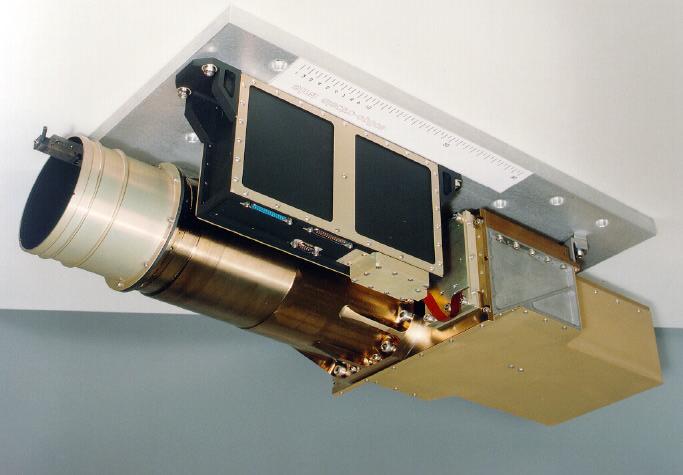
8 CHRIS
9 Specification & Performance
10 Specification Image area Spatial sampling interval Spectral range (nominal) Spectral resolution 18.6km x 18.6km (748 x 748 pixels) 25 or 50m 415nm to 1050nm 1.25 to 11nm Spectral registration ± 0.06 pixels Spatial registration ± 0.05 pixels Straylight Gain stage Digitisation 1% total for an extended source 4 levels (albedo 0.5,1,2,4 levels) 12 bits Signal-to-noise ratio 200 (@ target reflectance 0.2, 25m, 10nm)
11 Specification continued Data per (19x19 km 2 ) image 131 Mbits (16.4Mbytes) Number of images per orbit nominally 5 (81.9Mbytes) Power consumption < 10 W primary power Mass < 14 kg Volume 790 x 260 x 200 mm 3
12 MTF (ACROSS-TRACK) nm Across-track MTF - 546nm & columns 60, 380 & MTF Col 60 Col 380 Col Spatial frequency c/mm
13 Responsivity CHRIS Radiometric Calibration (G=3) Digital signal (ADU) for radiance of 1W/m^2/str/nm Wavelength nm
14 Wavelength Calibration WAVELENGTH CALIBRATION WAVELENGTH nm COLUMN NUMBER
15 Spectral Resolution SPECTRAL RESOLUTION AT 446 nm SPECTRAL RESOLUTION AT 546 nm SPECTRAL RESOLUTION AT 910 nm NORMALISED RESPONSE NORMALISED RESPONSE NORMALISED RESPONSE WAVELENGTH nm WAVELENGTH nm WAVELENGTH nm Wavelength FWHM 446 nm nm nm 10.6
16 Operating Modes

17 Multi-view CHRIS Data CHRIS will be able to acquire 5+ near-simultaneous views of any site
18 Platform Constraints Platform Pointing Along-track 0, ± 25º, ±44º pitch ground) Across-track <= +/-30º ground) Pointing Specification Absolute pitch/roll/yaw < +/- 0.1º Control of pitch/roll/yaw < +/ º/s (11% of imaging pitch rate) Maximum pitch rate 0.5º/s Observations baseline Motion compensation (approx. x3) Five images per observation orbit per day
19 Imaging Modes Earth Imaging Full 25m or 50m (nadir equivalent) Image 18.6 x 18.8 km Half 25 or 50m (nadir equivalent) Image 9.3 x 18.8 km Dark Imaging Eclipse observations Flat Fielding In-orbit solar calibration (yaw steer - limited aperture) Observation of ground calibration sites Internal LED source Wavelength calibration Selected ocean scene
20 Maximum number of spectral bands Name Across-track sampling nadir (number of image pixels) Along-track sampling nadir Maximum number of spectral bands per image line Full swath 25x25m 25m (748) 25m Full swath 50x25m 50m (374) 25m Full swath 50x50m 50m (374) 50m Half swath 25x25m 25m (374) 25m Half swath 50x25m 50m (190) 25m Half swath 50x50m 50m (190) 50m NB. One spectral band will be used for smear correction.
21 Calibration Plan
22 In-flight Calibration Flat field (monthly TBD) In-orbit solar calibration (yaw steer - limited aperture) Internal LED source Ground calibration sites DC Offsets (per observation orbit TBD) Dark reference pixels (located at side of CCD image area) Smear pixels (located at ends of CCD image area) Over-scanned pixels Eclipse observations (plus temperature monitoring) Wavelength (monthly TBD) Oxygen absorption 760nm
23 Routine Health Checks Offset & average dark signal levels Dark field non-uniformities Response non-uniformities Temporal noise Absolute spectral response Linearity
24 Data Processing Plans
25 Observational & Data Aspects Ground Station Receive data packets Transmit image & ancillary data Monitor satellite health Archive data PROBA Platform Recieve requests Schedule platform manoeuvres Command CHRIS Store image data Transmit to ground Ground Station Uplink requests Sira Format data Radiometric correction Wavelength correction Data validation Transmit data to users Arcive data sets Sira Collate & check requests Prepare configuration files Review scheduling options Transmit files to Redu User Processing Geo-correction Atmospheric correction Algorithm implementation Validation with ground site data Publication of results User Requests Longitude/Lattitude/Altitude Pointing requirements & limits Number of imaging lines Observation time (day/night) Spectral & spatial configuration Motion compensation level (tbd)
26 Processing Related Sira Validation & preparation of observing requests first level sanity checks of user requests generation of instrument configuration files etc. Level 1a data processing acquire data sets (1-4 weeks after observations) radiometric correction wavelength calibration (tbd) routine instrument health checks Production of data sets for users Supply data sets to users (1 week turn around) Format (tbd)
ENMAP RADIOMETRIC INFLIGHT CALIBRATION, POST-LAUNCH PRODUCT VALIDATION, AND INSTRUMENT CHARACTERIZATION ACTIVITIES
 ENMAP RADIOMETRIC INFLIGHT CALIBRATION, POST-LAUNCH PRODUCT VALIDATION, AND INSTRUMENT CHARACTERIZATION ACTIVITIES A. Hollstein1, C. Rogass1, K. Segl1, L. Guanter1, M. Bachmann2, T. Storch2, R. Müller2,
OPAL Optical Profiling of the Atmospheric Limb
 OPAL Optical Profiling of the Atmospheric Limb Alan Marchant Chad Fish Erik Stromberg Charles Swenson Jim Peterson OPAL STEADE Mission Storm Time Energy & Dynamics Explorers NASA Mission of Opportunity
EPS Bridge Low-Cost Satellite
 EPS Bridge Low-Cost Satellite Results of a Concept Study being performed for Dr. Hendrik Lübberstedt OHB-System AG OpSE Workshop Walberberg 8th November 2005 EPS Bridge Key System Requirements Minimum
Compact Multispectral and Hyperspectral Imagers based on a Wide Field of View TMA
 Compact Multispectral and Hyperspectral Imagers based on a Wide Field of View TMA M. Taccola (AOES),S. Grabarnik (AOES), L. Maresi (ESA/ESTEC), V. Moreau (AMOS), L. de Vos (OIP), Y. Versluys (OIP), G.
The Challenge. SPOT Vegetation. miniaturization. Proba Vegetation. Technology assessment:
 The Challenge Spot-5 lifetime expires in 2012. The next French satellite, Pleiades, is solely dedicated to HiRes. The Belgian Federal Science Policy Office (BELSPO) declared their interest to develop an
Sentinel-2 Products and Algorithms
 Sentinel-2 Products and Algorithms Ferran Gascon (Sentinel-2 Data Quality Manager) Workshop Preparations for Sentinel 2 in Europe, Oslo 26 November 2014 Sentinel-2 Mission Mission Overview Products and
Chapter 5 Nadir looking UV measurement.
 Chapter 5 Nadir looking UV measurement. Part-II: UV polychromator instrumentation and measurements -A high SNR and robust polychromator using a 1D array detector- UV spectrometers onboard satellites have
Wind Imaging Spectrometer and Humidity-sounder (WISH): a Practical NPOESS P3I High-spatial Resolution Sensor
: a Practical NPOESS P3I High-spatial Resolution Sensor") Wind Imaging Spectrometer and Humidity-sounder (WISH): a Practical NPOESS P3I High-spatial Resolution Sensor Jeffery J. Puschell Raytheon Space and Airborne Systems, El Segundo, California Hung-Lung Huang
Wind Imaging Spectrometer and Humidity-sounder (WISH): a Practical NPOESS P3I High-spatial Resolution Sensor Jeffery J. Puschell Raytheon Space and Airborne Systems, El Segundo, California Hung-Lung Huang
DESIS Applications & Processing Extracted from Teledyne & DLR Presentations to JACIE April 14, Ray Perkins, Teledyne Brown Engineering
 DESIS Applications & Processing Extracted from Teledyne & DLR Presentations to JACIE April 14, 2016 Ray Perkins, Teledyne Brown Engineering 1 Presentation Agenda Imaging Spectroscopy Applications of DESIS
Satellite/Aircraft Imaging Systems Imaging Sensors Standard scanner designs Image data formats
 CEE 6150: Digital Image Processing 1 Satellite/Aircraft Imaging Systems Imaging Sensors Standard scanner designs Image data formats CEE 6150: Digital Image Processing 2 CEE 6150: Digital Image Processing
AN INTRODUCTION TO MICROCARB, FIRST EUROPEAN PROGRAM FOR CO2 MONITORING.
 AN INTRODUCTION TO MICROCARB, FIRST EUROPEAN PROGRAM FOR CO2 MONITORING. International Working Group on Green house Gazes Monitoring from Space IWGGMS-12 Francois BUISSON CNES With Didier PRADINES, Veronique
DEFENSE APPLICATIONS IN HYPERSPECTRAL REMOTE SENSING
 DEFENSE APPLICATIONS IN HYPERSPECTRAL REMOTE SENSING James M. Bishop School of Ocean and Earth Science and Technology University of Hawai i at Mānoa Honolulu, HI 96822 INTRODUCTION This summer I worked
RECONNAISSANCE PAYLOADS FOR RESPONSIVE SPACE
 3rd Responsive Space Conference RS3-2005-5004 RECONNAISSANCE PAYLOADS FOR RESPONSIVE SPACE Charles Cox Stanley Kishner Richard Whittlesey Goodrich Optical and Space Systems Division Danbury, CT Frederick
Japan's Greenhouse Gases Observation from Space
 1 Workshop on EC CEOS Priority on GHG Monitoring Japan's Greenhouse Gases Observation from Space 18 June, 2018@Ispra, Italy Masakatsu NAKAJIMA Japan Aerospace Exploration Agency Development and Operation
OVERVIEW OF KOMPSAT-3A CALIBRATION AND VALIDATION
 OVERVIEW OF KOMPSAT-3A CALIBRATION AND VALIDATION DooChun Seo 1, GiByeong Hong 1, ChungGil Jin 1, DaeSoon Park 1, SukWon Ji 1 and DongHan Lee 1 1 KARI(Korea Aerospace Space Institute), 45, Eoeun-dong,
Advanced Optical Satellite (ALOS-3) Overviews
 Overviews") K&C Science Team meeting #24 Tokyo, Japan, January 29-31, 2018 Advanced Optical Satellite (ALOS-3) Overviews January 30, 2018 Takeo Tadono 1, Hidenori Watarai 1, Ayano Oka 1, Yousei Mizukami 1, Junichi
K&C Science Team meeting #24 Tokyo, Japan, January 29-31, 2018 Advanced Optical Satellite (ALOS-3) Overviews January 30, 2018 Takeo Tadono 1, Hidenori Watarai 1, Ayano Oka 1, Yousei Mizukami 1, Junichi
TopSat: Brief to Ground Segment Coordination. Presenter Ian Pilling. By : W.A. Levett. Co author: E.J. Baxter.
 TopSat: Brief to Ground Segment Coordination Board Presenter Ian Pilling By : W.A. Levett Co author: E.J. Baxter Contents Space Division overview The TopSat mission Overview Development Programme Launch
18. Infra-Red Imaging Subsystem (IRIS)
") 18. Infra-Red Imaging Subsystem (IRIS) Instrument Parameters Brodsky (1991) suggests the following parameters for remote sensing instruments: - focal plane detector, pattern, and cooling - dwell time on
18. Infra-Red Imaging Subsystem (IRIS) Instrument Parameters Brodsky (1991) suggests the following parameters for remote sensing instruments: - focal plane detector, pattern, and cooling - dwell time on
Table (1).Operation modes and configuration in CHRIS sensor [3] Operating No of. Keyword CHRIS Sensor, De-Striping, Electronic Effect, Noise.
![Table (1).Operation modes and configuration in CHRIS sensor [3] Operating No of. Keyword CHRIS Sensor, De-Striping, Electronic Effect, Noise.](/thumbs/90/102002832.jpg "Table (1).Operation modes and configuration in CHRIS sensor [3] Operating No of. Keyword CHRIS Sensor, De-Striping, Electronic Effect, Noise.") Detection and Elimination of Striped Noise in CHRIS-PROBA Sensor Images Mohammad Reza Mobasheri Associate Professor, Remote Sensing Department, KhajeNasirToosi University of Technology, Tehran, Islamic
Detection and Elimination of Striped Noise in CHRIS-PROBA Sensor Images Mohammad Reza Mobasheri Associate Professor, Remote Sensing Department, KhajeNasirToosi University of Technology, Tehran, Islamic
1. INTRODUCTION. GOCI : Geostationary Ocean Color Imager
 1. INTRODUCTION The Korea Ocean Research and Development Institute (KORDI) releases an announcement of opportunity (AO) to carry out scientific research for the utilization of GOCI data. GOCI is the world
AMIPAS. Advanced Michelson Interferometer for Passive Atmosphere Sounding. Concepts and Technology for Future Atmospheric Chemistry Sensors
 Earth Observation, Navigation & Science Concepts and Technology for Future Atmospheric Chemistry Sensors AMIPAS Advanced Michelson Interferometer for Passive Atmosphere Sounding Markus Melf, Winfried Posselt,
MicroCarb Mission: A new space instrumental concept based on dispersive components for the measurement of CO2 concentration in the atmosphere
 International Conference on Space Optics 2012 MicroCarb Mission: A new space instrumental concept based on dispersive components for the measurement of CO2 concentration in the atmosphere Véronique PASCAL
MERIS instrument. Muriel Simon, Serco c/o ESA
 MERIS instrument Muriel Simon, Serco c/o ESA Workshop on Sustainable Development in Mountain Areas of Andean Countries Mendoza, Argentina, 26-30 November 2007 ENVISAT MISSION 2 Mission Chlorophyll case
Observing Nightlights from Space with TEMPO James L. Carr 1,Xiong Liu 2, Brian D. Baker 3 and Kelly Chance 2
 Observing Nightlights from Space with TEMPO James L. Carr 1,Xiong Liu 2, Brian D. Baker 3 and Kelly Chance 2 September 27, 2016 1 Carr Astronautics Corp., Greenbelt, MD, USA jcarr@carrastro.com 2 Harvard-Smithsonian
BAFFLES DESIGN OF THE PROBA-V WIDE FOV TMA
 BAFFLES DESIGN OF THE PROBA-V WIDE FOV TMA A. Mazzoli 1, P. Holbrouck 2, Y. Houbrechts 1, L. Maresi 3, Y. Stockman 1, M.Taccola 3, J. Versluys 2. 1 Centre Spatial de Liège (CSL), University of Liège, Avenue
Mission requirements and satellite overview
 Mission requirements and satellite overview E. BOUSSARIE 1 Dual concept Users need Defence needs Fulfil the Defence needs on confidentiality and security Civilian needs Fulfillment of the different needs
Remote Sensing Calibration Solutions
 Remote Sensing Calibration Solutions Cameras, Sensors and Focal Plane Arrays Multispectral and Hyperspectral Imagers Small Satellite Imagers Earth Observation Systems SWIR Band Science and Imaging Reconnaissance
Radiometric Use of WorldView-3 Imagery. Technical Note. 1 WorldView-3 Instrument. 1.1 WorldView-3 Relative Radiance Response
 Radiometric Use of WorldView-3 Imagery Technical Note Date: 2016-02-22 Prepared by: Michele Kuester This technical note discusses the radiometric use of WorldView-3 imagery. The first two sections briefly
Calibration of a Multi-Spectral CubeSat with LandSat Filters
 Calibration of a Multi-Spectral CubeSat with LandSat Filters Sloane Wiktorowicz, Ray Russell, Dee Pack, Eric Herman, George Rossano, Christopher Coffman, Brian Hardy, & Bonnie Hattersley (The Aerospace
Cross Track Infrared Sounder (CrIS) Flight Model 1 Test Results
 Flight Model 1 Test Results") May 6, 2009 Ronald Glumb, Joseph P. Predina, Robert Hookman, Chris Ellsworth, John Bobilya, Steve Wells, Lawrence Suwinski, Rebecca Frain, and Larry Crawford For Publication at the ASS-FTS14 Conference
May 6, 2009 Ronald Glumb, Joseph P. Predina, Robert Hookman, Chris Ellsworth, John Bobilya, Steve Wells, Lawrence Suwinski, Rebecca Frain, and Larry Crawford For Publication at the ASS-FTS14 Conference
The Hyperspectral UAV (HyUAV) a novel UAV-based spectroscopy tool for environmental monitoring
 a novel UAV-based spectroscopy tool for environmental monitoring") The Hyperspectral UAV (HyUAV) a novel UAV-based spectroscopy tool for environmental monitoring R. Garzonio 1, S. Cogliati 1, B. Di Mauro 1, A. Zanin 2, B. Tattarletti 2, F. Zacchello 2, P. Marras 2 and
The Hyperspectral UAV (HyUAV) a novel UAV-based spectroscopy tool for environmental monitoring R. Garzonio 1, S. Cogliati 1, B. Di Mauro 1, A. Zanin 2, B. Tattarletti 2, F. Zacchello 2, P. Marras 2 and
KOMPSAT Constellation. November 2012 Satrec Initiative
 KOMPSAT Constellation November 2012 Satrec Initiative KOMPSAT Constellation KOMPSAT National program Developed and operated by KARI (Korea Aerospace Research Institute) Dual use : Government & commercial
From Proba-V to Proba-MVA
 From Proba-V to Proba-MVA Fabrizio Niro ESA Sensor Performances Products and Algorithm (SPPA) ESA UNCLASSIFIED - For Official Use Proba-V extension in the Copernicus era Proba-V was designed with the main
CubeSat-Scale Hyperspectral Imager for Middle Atmosphere Investigations
 CubeSat-Scale Hyperspectral Imager for Middle Atmosphere Investigations Rick Doe 1, Steve Watchorn 2, John Noto 2, Robert Kerr 2, Karl van Dyk 1, Kyle Leveque 1, and Christopher Sioris 3 1 SRI International
Kazuhiro TANAKA GCOM project team/jaxa April, 2016
 Kazuhiro TANAKA GCOM project team/jaxa April, 216 @ SPIE Asia-Pacific 216 at New Dehli, India 1 http://suzaku.eorc.jaxa.jp/gcom_c/index_j.html GCOM mission and satellites SGLI specification and IRS overview
On the use of water color missions for lakes in 2021
 Lakes and Climate: The Role of Remote Sensing June 01-02, 2017 On the use of water color missions for lakes in 2021 Cédric G. Fichot Department of Earth and Environment 1 Overview 1. Past and still-ongoing
Status of Meteosat Third Generation (MTG) Pre-Phase A System Architecture Studies
 Pre-Phase A System Architecture Studies") Status of Meteosat Third Generation (MTG) Pre-Phase A System Architecture Studies Paolo Bensi, Earth Observation Future Programme Department European Space Agency Planning: Meteosat Third Generation (MTG)
Status of Meteosat Third Generation (MTG) Pre-Phase A System Architecture Studies Paolo Bensi, Earth Observation Future Programme Department European Space Agency Planning: Meteosat Third Generation (MTG)
First inflight results of Pleiades-1A innovative methods for optical calibration
 ICSO 2012 / Imagers and Radiometers First inflight results of Pleiades-1A innovative methods for optical calibration Philippe KUBIK Octobre 9 th, 2012 philippe.kubik@cnes.fr Titre du document + date Arial
CAGE No TITLE. EO-1/ Hyperion Science Data User s Guide. DATE: May 2001 NO. HYP.TO REV Original. Superseding:
 TRW Space, Defense & Information Systems One Space Park Redondo Beach, CA 90278 TRW CAGE No. 11982 TITLE EO-1/ Hyperion Science Data User s Guide DATE: May 2001 NO. REV Original Superseding: PREPARED BY:
NASTER System Definition Proposal
 Remote Sensing Team NASTER System Definition Proposal All rights reserved. - 7/14/03 Page 1 Overview Review and comment the mid-ir requirements Presentation of ABB s current platform technology Proposed
of the Small Satellite Mission Systematic Image Processing Eckehard Lorenz, DLR Berlin Ilmenau, Klaus Briess, TU Berlin 49th IWK
 Ilmenau, 27.-30.09. 2004 49th IWK Eckehard Lorenz, DLR Berlin Klaus Briess, TU Berlin Astro- und Feinwerktechnik Adlershof GmbH Systematic Image Processing of the Small Satellite Mission BIRD Optical Information
MERIS US Workshop. Instrument Overview. Steven Delwart
 MERIS US Workshop Instrument Overview Steven Delwart ENVISAT Acknowledgement To the ENVISAT Team & MERIS Instrument Engineers Jean-Loup Bezy George Gourmelon ENVISAT- MERIS 120M 200 Kg 1m 3 175 W MERIS
Japanese Advanced Meteorological Imager: A Next Generation GEO Imager for MTSAT-1R
 Japanese Advanced Meteorological Imager: A Next Generation GEO Imager for MTSAT-1R Jeffery J. Puschell 1 Raytheon Electronic Systems, Santa Barbara Remote Sensing ABSTRACT The Japanese Advanced Meteorological
On-Orbit Radiometric Performance of the Landsat 8 Thermal Infrared Sensor. External Editors: James C. Storey, Ron Morfitt and Prasad S.
 Remote Sens. 2014, 6, 11753-11769; doi:10.3390/rs61211753 OPEN ACCESS remote sensing ISSN 2072-4292 www.mdpi.com/journal/remotesensing Article On-Orbit Radiometric Performance of the Landsat 8 Thermal
Low Cost Earth Sensor based on Oxygen Airglow
 Assessment Executive Summary Date : 16.06.2008 Page: 1 of 7 Low Cost Earth Sensor based on Oxygen Airglow Executive Summary Prepared by: H. Shea EPFL LMTS herbert.shea@epfl.ch EPFL Lausanne Switzerland
Five Years Orbit Experience of a Small Satellite Hyperspectral Imaging Mission. Mike Cutter & Martin Sweeting. AIAA Utah, August 2007
 Five Years Orbit Experience of a Small Satellite Hyperspectral Imaging Mission Mike Cutter & Martin Sweeting AIAA Utah, August 2007 SSTL - the company Surrey Satellite Technology Ltd is a private British
METimage Calibration & Performance Verification. Xavier Gnata ICSO 2016
 METimage Calibration & Performance Verification Xavier Gnata ICSO 2016 METimage factsheet Mission Passive imaging radiometer (multi-spectral) 20 spectral channels (443 13.345nm) Global coverage within
Status of the CNES / MicroCarb small
 Status of the CNES / MicroCarb small satellite for CO 2 measurements D. Jouglet on behalf of the MicroCarb team (F. Buisson, D. Pradines, V. Pascal, C. Pierangelo, C. Buil, S. Gaugain, C. Deniel, F.M.
Introduction to Remote Sensing
 Introduction to Remote Sensing Daniel McInerney Urban Institute Ireland, University College Dublin, Richview Campus, Clonskeagh Drive, Dublin 14. 16th June 2009 Presentation Outline 1 2 Spaceborne Sensors
OVERVIEW OF THE PRISMA SPACE AND GROUND SEGMENT AND ITS HYPERSPECTRAL PRODUCTS
 IEEE International Geoscience and Remote Sensing Symposium OVERVIEW OF THE PRISMA SPACE AND GROUND SEGMENT AND ITS HYPERSPECTRAL PRODUCTS Rocchina Guarini, Rosa Loizzo, Francesco Longo, Silvia Mari, Tiziana
Radiometric performance of Second Generation Global Imager (SGLI) using integrating sphere
 using integrating sphere") Radiometric performance of Second Generation Global Imager (SGLI) using integrating sphere Taichiro Hashiguchi, Yoshihiko Okamura, Kazuhiro Tanaka, Yukinori Nakajima Japan Aerospace Exploration Agency
Radiometric performance of Second Generation Global Imager (SGLI) using integrating sphere Taichiro Hashiguchi, Yoshihiko Okamura, Kazuhiro Tanaka, Yukinori Nakajima Japan Aerospace Exploration Agency
International Conference on Space Optics ICSO 2014 La Caleta, Tenerife, Canary Islands 7 10 October /cso _2014 ono ' r
 International Conference on Space Optics La Caleta, Tenerife, Canary Islands 7 10 October 2014 Edited by Zoran Sodnik, Bruno Cugny, and Nikos Karafolas /cso _2014 ono ' r 6 October 2014: La Palma Excursion
Hyper-spectral, UHD imaging NANO-SAT formations or HAPS to detect, identify, geolocate and track; CBRN gases, fuel vapors and other substances
 Hyper-spectral, UHD imaging NANO-SAT formations or HAPS to detect, identify, geolocate and track; CBRN gases, fuel vapors and other substances Arnold Kravitz 8/3/2018 Patent Pending US/62544811 1 HSI and
for the NASA Earth Observing-1 Mission ABSTRACT 1. INTRODUCTION
 Approved for public release; distribution is unlimited. Hyperion: A 0.4 µm - 2.5 µm Hyperspectral Imager for the NASA Earth Observing-1 Mission Paul Lee, Steve Carman, C. K. Chan, Marty Flannery, Mark
THE OFFICINE GALILEO DIGITAL SUN SENSOR
 THE OFFICINE GALILEO DIGITAL SUN SENSOR Franco BOLDRINI, Elisabetta MONNINI Officine Galileo B.U. Spazio- Firenze Plant - An Alenia Difesa/Finmeccanica S.p.A. Company Via A. Einstein 35, 50013 Campi Bisenzio
The Global Imager (GLI)
") The Global Imager (GLI) Launch : Dec.14, 2002 Initial check out : to Apr.14, 2003 (~L+4) First image: Jan.25, 2003 Second image: Feb.6 and 7, 2003 Calibration and validation : to Dec.14, 2003(~L+4) for
The Global Imager (GLI) Launch : Dec.14, 2002 Initial check out : to Apr.14, 2003 (~L+4) First image: Jan.25, 2003 Second image: Feb.6 and 7, 2003 Calibration and validation : to Dec.14, 2003(~L+4) for
CHAPTER --'3 DATA DESCRIPTION
 CHAPTER --'3 DATA DESCRIPTION 37 3.1 INTRODUCTION In chapter 2 different techniques used for the study of polar cryosphere like passive and active remote sensing, altimetry and scatterometry are described.
Rochester Institute of Technology. Wildfire Airborne Sensor Program (WASP) Project Overview
 Project Overview") Rochester Institute of Technology Wildfire Airborne Sensor Program (WASP) Project Overview Introduction The following slides describe a program underway at RIT The sensor system described herein is being
Rochester Institute of Technology Wildfire Airborne Sensor Program (WASP) Project Overview Introduction The following slides describe a program underway at RIT The sensor system described herein is being
AIAA/USU Small Satellite Conference 2007 Paper No. SSC07-VIII-2
 Digital Imaging Space Camera (DISC) Design & Testing Mitch Whiteley Andrew Shumway, Presenter Quinn Young Robert Burt Jim Peterson Jed Hancock James Peterson AIAA/USU Small Satellite Conference 2007 Paper
PROBA V Multispectral Imager: Status
 PROBA V Multispectral Imager: Status Alessandro Zuccaro Marchi, Matteo Taccola, Michael François, Ignacio Torralba ESTEC, European Space Agency Noordwijk, The Netherlands alessandro.zuccaro.marchi@esa.int
THE HYMAP TM AIRBORNE HYPERSPECTRAL SENSOR: THE SYSTEM, CALIBRATION AND PERFORMANCE
 THE HYMAP TM AIRBORNE HYPERSPECTRAL SENSOR: THE SYSTEM, CALIBRATION AND PERFORMANCE T. Cocks, R. Jenssen, A. Stewart, I. Wilson* and T. Shields* Integrated Spectronics Pty Ltd, P.O. Box 437, Baulkham Hills,
Miguel A. Aguirre. Introduction to Space. Systems. Design and Synthesis. ) Springer
 Springer") Miguel A. Aguirre Introduction to Space Systems Design and Synthesis ) Springer Contents Foreword Acknowledgments v vii 1 Introduction 1 1.1. Aim of the book 2 1.2. Roles in the architecture definition
Miguel A. Aguirre Introduction to Space Systems Design and Synthesis ) Springer Contents Foreword Acknowledgments v vii 1 Introduction 1 1.1. Aim of the book 2 1.2. Roles in the architecture definition
Chapter 8. Remote sensing
 1. Remote sensing 8.1 Introduction 8.2 Remote sensing 8.3 Resolution 8.4 Landsat 8.5 Geostationary satellites GOES 8.1 Introduction What is remote sensing? One can describe remote sensing in different
Hyperspectral goes to UAV and thermal
 Hyperspectral goes to UAV and thermal Timo Hyvärinen, Hannu Holma and Esko Herrala SPECIM, Spectral Imaging Ltd, Finland www.specim.fi Outline Roadmap to more compact, higher performance hyperspectral
The Advanced Along-Track Scanning Radiometer (AATSR) Mission Status and Early Results
 Mission Status and Early Results") The Advanced Along-Track Scanning Radiometer (AATSR) Mission Status and Early Results M. C. Edwards (University of Leicester, UK) D. Llewellyn-Jones (University of Leicester, UK) D. L. Smith (Rutherford
The Advanced Along-Track Scanning Radiometer (AATSR) Mission Status and Early Results M. C. Edwards (University of Leicester, UK) D. Llewellyn-Jones (University of Leicester, UK) D. L. Smith (Rutherford
Meteosat Third Generation (MTG) Lightning Imager (LI) instrument on-ground and in-flight calibration
 Lightning Imager (LI) instrument on-ground and in-flight calibration") Meteosat Third Generation (MTG) Lightning Imager (LI) instrument on-ground and in-flight calibration Marcel Dobber, Stephan Kox EUMETSAT (Darmstadt, Germany) 1 Contents of this presentation Meteosat Third
Meteosat Third Generation (MTG) Lightning Imager (LI) instrument on-ground and in-flight calibration Marcel Dobber, Stephan Kox EUMETSAT (Darmstadt, Germany) 1 Contents of this presentation Meteosat Third
Congress Best Paper Award
 Congress Best Paper Award Preprints of the 3rd IFAC Conference on Mechatronic Systems - Mechatronics 2004, 6-8 September 2004, Sydney, Australia, pp.547-552. OPTO-MECHATRONIC IMAE STABILIZATION FOR A COMPACT
Two-linear-polarization measurement of O 2 A band with TANSO-FTS onboard GOSAT
 Remote sensing in the O 2 A band Two-linear-polarization measurement of O 2 A band with TANSO-FTS onboard GOSAT July 7, 2016, De Bilt Akihiko Kuze, Hiroshi Suto, Kei Shiomi, Nobuhiro Kikuchi, Makiko Hashimoto
Comprehensive Vicarious Calibration and Characterization of a Small Satellite Constellation Using the Specular Array Calibration (SPARC) Method
 Method") This document does not contain technology or Technical Data controlled under either the U.S. International Traffic in Arms Regulations or the U.S. Export Administration Regulations. Comprehensive Vicarious
This document does not contain technology or Technical Data controlled under either the U.S. International Traffic in Arms Regulations or the U.S. Export Administration Regulations. Comprehensive Vicarious
The CarbonSat candidate mission - Radiometric and Spectral Performances over Spatially Heterogeneous Scenes
 The CarbonSat candidate mission - Radiometric and Spectral Performances over Spatially Heterogeneous Scenes J. Caron, B. Sierk, J.-L. Bézy, A. Loescher, Y. Meijer ESA-Estec (Netherlands) Earth Observation
Advanced Meteorological Imager (AMI) Development for GEO-KOMPSAT-2A
 Development for GEO-KOMPSAT-2A") 1 st KMA International Meteorological Satellite Conference Advanced Meteorological Imager (AMI) Development for GEO-KOMPSAT-2A 16 November 2015 Koon-Ho YANG Korea Aerospace Research Institute 1 Agenda
1 st KMA International Meteorological Satellite Conference Advanced Meteorological Imager (AMI) Development for GEO-KOMPSAT-2A 16 November 2015 Koon-Ho YANG Korea Aerospace Research Institute 1 Agenda
EUROPEAN SPACE AGENCY INDUSTRIAL POLICY COMMITTEE
 Att. : Annexes Paris, 20 th March 2008 (English only) EUROPEAN SPACE AGENCY INDUSTRIAL POLICY COMMITTEE GENERAL SUPPORT TECHNOLOGY PROGRAMME UPDATE OF THE GSTP-4 SPECIFIC AREA WORK PLAN AND PROCUREMENT
Consumer digital CCD cameras
 CAMERAS Consumer digital CCD cameras Leica RC-30 Aerial Cameras Zeiss RMK Zeiss RMK in aircraft Vexcel UltraCam Digital (note multiple apertures Lenses for Leica RC-30. Many elements needed to minimize
Time Trend Evaluations of Absolute Accuracies for PRISM and AVNIR-2
 The 3 rd ALOS Joint PI Symposium, Kona, Hawaii, US Nov. 9-13, 2009 Time Trend Evaluations of Absolute Accuracies for PRISM and AVNIR-2 Takeo Tadono*, Masanobu Shimada*, Hiroshi Murakami*, Junichi Takaku**,
Sensor resolutions from space: the tension between temporal, spectral, spatial and swath. David Bruce UniSA and ISU
 Sensor resolutions from space: the tension between temporal, spectral, spatial and swath David Bruce UniSA and ISU 1 Presentation aims 1. Briefly summarize the different types of satellite image resolutions
The studies began when the Tiros satellites (1960) provided man s first synoptic view of the Earth s weather systems.
 provided man s first synoptic view of the Earth s weather systems.") Remote sensing of the Earth from orbital altitudes was recognized in the mid-1960 s as a potential technique for obtaining information important for the effective use and conservation of natural resources.
Remote sensing of the Earth from orbital altitudes was recognized in the mid-1960 s as a potential technique for obtaining information important for the effective use and conservation of natural resources.
VICARIOUS CALIBRATION SITE SELECTION FOR RAZAKSAT MEDIUM-SIZED APERTURE CAMERA (MAC)
") VICARIOUS CALIBRATION SITE SELECTION FOR RAZAKSAT MEDIUM-SIZED APERTURE CAMERA (MAC) Lee Yee Hwai a, Mazlan Hashim b, Ahmad Sabirin Arshad a a Astronautic Technology (M) Sdn Bhd (yee_hwai, sabirin)@atsb.com.my
VICARIOUS CALIBRATION SITE SELECTION FOR RAZAKSAT MEDIUM-SIZED APERTURE CAMERA (MAC) Lee Yee Hwai a, Mazlan Hashim b, Ahmad Sabirin Arshad a a Astronautic Technology (M) Sdn Bhd (yee_hwai, sabirin)@atsb.com.my
RADIOMETRIC CALIBRATION
 1 RADIOMETRIC CALIBRATION Lecture 10 Digital Image Data 2 Digital data are matrices of digital numbers (DNs) There is one layer (or matrix) for each satellite band Each DN corresponds to one pixel 3 Digital
Comparison of off-axis TMA and FMA telescopes optimized over different fields of view: applications to Earth observation
 Comparison of off-axis TMA and FMA telescopes optimized over different fields of view: applications to Earth observation L. Clermont* a, Y. Stockman a, W. Dierckx b, J. Loicq a a Centre Spatial de Liège,
Characterization of the atmospheric aerosols and the surface radiometric properties in the AGRISAR Campaign
 Characterization of the atmospheric aerosols and the surface radiometric properties in the AGRISAR Campaign V. Estellés Solar Radiation Unit Universitat de València T. Ruhtz, P. Zieger, S. Stapelberg Institute
QUANTITATIVE GLOBAL MAPPING OF TERRESTRIAL VEGETATION PHOTOSYNTHESIS: THE FLUORESCENCE EXPLORER (FLEX) MISSION
 MISSION") 2017 IEEE International Geoscience and Remote Sensing Symposium July 23 28, 2017 Fort Worth, Texas, USA Session MO3.L12 - International Spaceborne Imaging Spectroscopy Missions: Updates and News I QUANTITATIVE
2017 IEEE International Geoscience and Remote Sensing Symposium July 23 28, 2017 Fort Worth, Texas, USA Session MO3.L12 - International Spaceborne Imaging Spectroscopy Missions: Updates and News I QUANTITATIVE
Optical Correlator for Image Motion Compensation in the Focal Plane of a Satellite Camera
 15 th IFAC Symposium on Automatic Control in Aerospace Bologna, September 6, 2001 Optical Correlator for Image Motion Compensation in the Focal Plane of a Satellite Camera K. Janschek, V. Tchernykh, -
A CONCEPT FOR A REGIONAL COASTAL ZONE MISSION
 A CONCEPT FOR A REGIONAL COASTAL ZONE MISSION J. Nieke a, b, A. Neumann b, H. Schwarzer b, B. Penné c a NASDA, Earth Observation Research Center, 1-8-10, Harumi, 104-6023 Tokyo, Japan b DLR, German Aerospace
CHRIS-PROBA PERFORMANCE EVALUATION: SIGNAL-TO-NOISE RATIO, INSTRUMENT EFFICIENCY AND DATA QUALITY FROM ACQUISITIONS OVER SAN ROSSORE (ITALY) TEST SITE
 TEST SITE") CHRIS-PROBA PERFORMANCE EVALUATION: SIGNAL-TO-NOISE RATIO, INSTRUMENT EFFICIENCY AND DATA QUALITY FROM ACQUISITIONS OVER SAN ROSSORE (ITALY) TEST SITE Alessandro Barducci (1), Donatella Guzzi (1), Paolo
CHRIS-PROBA PERFORMANCE EVALUATION: SIGNAL-TO-NOISE RATIO, INSTRUMENT EFFICIENCY AND DATA QUALITY FROM ACQUISITIONS OVER SAN ROSSORE (ITALY) TEST SITE Alessandro Barducci (1), Donatella Guzzi (1), Paolo
Radiometric Solar Telescope (RaST) The case for a Radiometric Solar Imager,
 The case for a Radiometric Solar Imager,") SORCE Science Meeting 29 January 2014 Mark Rast Laboratory for Atmospheric and Space Physics University of Colorado, Boulder Radiometric Solar Telescope (RaST) The case for a Radiometric Solar Imager,
SORCE Science Meeting 29 January 2014 Mark Rast Laboratory for Atmospheric and Space Physics University of Colorado, Boulder Radiometric Solar Telescope (RaST) The case for a Radiometric Solar Imager,
metcon meteorologieconsultgmbh, Instruments for Atmospheric Research W1aa_Feb_2017_1.doc 1 -
 metcon meteorologieconsultgmbh, Instruments for Atmospheric Research W1aa_Feb_2017_1.doc 1 - ACTINIC FLUX SPECTRAL RADIOMETERS Ultra-fast CCD-Detector Spectrometer, UVB enhanced Cooled CCD, 512 pixel *
specification display applications hera spectrometer
 specification display applications hera spectrometer Contents 1 Hera: cost effective spectrometer for display measurements... 3 2 Highlights... 3 3 Speed & ease of use... 4 4 General specification Hera
Geospatial Vision and Policies Korean Industry View 26 November, 2014 SI Imaging Services
 Geospatial Vision and Policies Korean Industry View 26 November, 2014 SI Imaging Services Distribution Limitation, SI Imaging Services Proprietary Data : The data contained in this document, without the
SHALOM: SPACEBORNE HYPERSPECTRAL APPLICATIVE LAND AND OCEAN MISSION: A JOINT PROJECT OF ASI-ISA AN UPDTAE FOR 2014
 SHALOM: SPACEBORNE HYPERSPECTRAL APPLICATIVE LAND AND OCEAN MISSION: A JOINT PROJECT OF ASI-ISA AN UPDTAE FOR 2014 Eyal Ben Dor Tel Aviv University Avia Kafri Israel Space Agency (ISA) Giancarlo Varacalli
GMES Sentinel-2. The Optical High Resolution Mission for GMES Operational Services
 GMES Sentinel-2 The Optical High Resolution Mission for GMES Operational Services Philippe Martimort GMES Sentinel-2 Mission and Payload Manager, ESA/ESTEC 15 October 2007, AGRISAR Workshop, Noordwijk
Application of GIS to Fast Track Planning and Monitoring of Development Agenda
 Application of GIS to Fast Track Planning and Monitoring of Development Agenda Radiometric, Atmospheric & Geometric Preprocessing of Optical Remote Sensing 13 17 June 2018 Outline 1. Why pre-process remotely
Hyperspectral Image capture and analysis of The Scream (1893)
") Hyperspectral Image capture and analysis of The Scream (1893) Ferdinand Deger, Sony Georg, Jon Y. Hardeberg Hyperspectral Imaging Acquisition of The Scream National museum in Oslo: Trond Aslaksby (Restorer)
Hyperspectral Image capture and analysis of The Scream (1893) Ferdinand Deger, Sony Georg, Jon Y. Hardeberg Hyperspectral Imaging Acquisition of The Scream National museum in Oslo: Trond Aslaksby (Restorer)
Spectral Analysis of the LUND/DMI Earthshine Telescope and Filters
 Spectral Analysis of the LUND/DMI Earthshine Telescope and Filters 12 August 2011-08-12 Ahmad Darudi & Rodrigo Badínez A1 1. Spectral Analysis of the telescope and Filters This section reports the characterization
Chapter 5. Preprocessing in remote sensing
 Chapter 5. Preprocessing in remote sensing 5.1 Introduction Remote sensing images from spaceborne sensors with resolutions from 1 km to < 1 m become more and more available at reasonable costs. For some
MASSACHUSETTS INSTITUTE OF TECHNOLOGY LINCOLN LABORATORY 244 WOOD STREET LEXINGTON, MASSACHUSETTS
 MASSACHUSETTS INSTITUTE OF TECHNOLOGY LINCOLN LABORATORY 244 WOOD STREET LEXINGTON, MASSACHUSETTS 02420-9108 3 February 2017 (781) 981-1343 TO: FROM: SUBJECT: Dr. Joseph Lin (joseph.lin@ll.mit.edu), Advanced
Multispectral Scanners for Wildland Fire Assessment NASA Ames Research Center Earth Science Division. Bruce Coffland U.C.
 Multispectral Scanners for Wildland Fire Assessment NASA Earth Science Division Bruce Coffland U.C. Santa Cruz Slide Fire Burn Area (MASTER/B200) R 2.2um G 0.87um B 0.65um Airborne Science & Technology
RADIATION BUDGET INSTRUMENT (RBI): FINAL DESIGN AND INITIAL EDU TEST RESULTS
: FINAL DESIGN AND INITIAL EDU TEST RESULTS") Place image here (10 x 3.5 ) RADIATION BUDGET INSTRUMENT (RBI): FINAL DESIGN AND INITIAL EDU TEST RESULTS RONALD GLUMB, JAY OVERBECK, CHRISTOPHER LIETZKE, JOHN FORSYTHE, ALAN BELL, AND JASON MILLER NON-EXPORT
Place image here (10 x 3.5 ) RADIATION BUDGET INSTRUMENT (RBI): FINAL DESIGN AND INITIAL EDU TEST RESULTS RONALD GLUMB, JAY OVERBECK, CHRISTOPHER LIETZKE, JOHN FORSYTHE, ALAN BELL, AND JASON MILLER NON-EXPORT
Performance status of IASI on MetOp-A and MetOp-B
 Performance status of IASI on MetOp-A and MetOp-B E. Jacquette (1), E. Péquignot (1), J. Chinaud (1), C. Maraldi (1), D. Jouglet (1), S. Gaugain (1), L. Buffet (1), C. Villaret (1), C. Larigauderie (1),
GEOMETRIC RECTIFICATION OF EUROPEAN HISTORICAL ARCHIVES OF LANDSAT 1-3 MSS IMAGERY
 GEOMETRIC RECTIFICATION OF EUROPEAN HISTORICAL ARCHIVES OF LANDSAT -3 MSS IMAGERY Torbjörn Westin Satellus AB P.O.Box 427, SE-74 Solna, Sweden tw@ssc.se KEYWORDS: Landsat, MSS, rectification, orbital model
AN UPDATE OF MICROCARB PROJECT PROGRESS AND PERSPECTIVE.
 AN UPDATE OF MICROCARB PROJECT PROGRESS AND PERSPECTIVE. PROJECT STATUS Francois BUISSON CNES June 8th, 2017 1 13th IWGGMS Helsinki June 6-8, 2017 PROJECT IMPLEMENTATION STATUS Decision milestones è Dec.,