The Advanced Along-Track Scanning Radiometer (AATSR) Mission Status and Early Results
|
|
|
- Victor Casey
- 6 years ago
- Views:
Transcription
1 The Advanced Along-Track Scanning Radiometer (AATSR) Mission Status and Early Results M. C. Edwards (University of Leicester, UK) D. Llewellyn-Jones (University of Leicester, UK) D. L. Smith (Rutherford Appleton Laboratory, UK) H. Tait (VEGA Group, UK) Page 1
2 Presentation Overview! Introduction to AATSR Mission Background Principles of Operation Products! Status of Commissioning! Instrument Performance! Algorithm Verification and Geophysical Validation! Early AATSR Images! Summary and Conclusions Page 2
3 Advanced Along Track Scanning Radiometer Mission Background! Funded primarily by the UK Department for Environment, Food and Rural Affairs (DEFRA) to support programme of climate research and prediction! Designed to measure sea surface temperature at the levels of precision and accuracy required for climate research (better than 0.3 K ± 1 sigma limit)! Third in a series: ATSR, ATSR-2 and AATSR! 15+ year record of accurate SST measurements on a global scale! Data for a wide range of other applications (land, oceans, cryosphere and atmosphere) Page 3

4 AATSR Principles of Operation! 7 spectral channels 3 IR (3.7 m, 11 m, 12 m) 4 Vis/NIR (0.55 m, 0.67 m, 0.87 m, 1.6 m)! 500 km swath! 1 km IFOV at nadir! On board calibration 2 on-board black bodies for IR calibration VISCAL unit for visible channel calibration! Stirling Cycle Coolers, cooling low noise detectors to 80K! Dual view Page 4
5 Name Level 0 GBTR Gridded BT/Reflectance Browse GST Gridded Surface Temp. AST Averaged Surface Temp. Meteo Product ID ATS_NR 0P ATS_TOA_1P ATS_AST_BP ATS_NR 2P ATS_AR 2P ATS_MET_2P AATSR Products Description Instrument source packets Full resolution top-of-atmosphere BT/reflectance for all channels and both views (1 km resolution) 3 band colour composite browse image (4x4 km sampling of GBTR) Full resolution SST, land and cloud parameters Spatially averaged SST, land and cloud parameters, over 50km and half degree cells SST and averaged BT for all clear sea pixels, 10 arc min cells, for Meteo users Page 5
6 Current Status of Commissioning Activities! Almost all SODAP commanding completed Instrument switch-on Instrument checkout First cooldown and instrument optimisation, including: Scan mechanism checkout Black Body tests Pixel map alignment verification Visible gain and IR gain-offset loop optimisation! Cooler Checkout to be re-run mid-july! No major on-board instrument anomalies! Instrument now running nominally! Analysis of data acquired ongoing Page 6
7 Instrument Performance to Date (1) Blackbody Calibration Subsystem Both Black Bodies are performing well +XBB -XBB Reading Difference Reading Difference Baseplate average PRT PRT PRT PRT PRT PRT6* Page 7
8 Instrument Performance to Date (2) Visible Calibration System Good signal, expected duration Further characterisation over time is ongoing Page 8
9 Instrument Performance to Date (3a) Cooler/Focal Plane Assembly Cool down to 80K achieved within 5 hours Page 9
10 Instrument Performance to Date (3b) Cooler/Focal Plane Assembly Following cool down, temperature of FPA remains stable (± 0.3K) Page 10
11 Instrument Performance to Date (4) Scan Mirror Scan mechanism is running in as expected Levels of jitter observed so far are lower than the equivalent on ATSR-2 Temperature and power consumption of SMU are as expected Scan rate = 150 msec/scan Pixel Map Alignment All segments of the pixel map have clear views of their targets with the default pixel map. No major modifications required. Page 11
12 Instrument Performance to Date (5)! Radiometric Performance Analysis of signal to noise etc. not complete NEDT below 50 mk on IR channels Dark noise on visible channels below digitisation levels Frequency analysis on BB signal shows no significant pickup below 3 Hz from the cooler or other mechanisms. Results are comparable to ATSR-2 levels Page 12
13 Algorithm Verification! Samples from these data are currently being examined as part of an Algorithm Verification exercise. Objectives are: Check product format Check product content against algorithms applied Review/optimise auxiliary data used in processing Page 13
14 AATSR Validation Programme! Comprehensive validation programme during the commissioning phase and throughout the mission! Objectives: To determine whether the AATSR instrument is returning an acceptable global skin SST To make an assessment of the quality and accuracy of AATSR data products! SST validation: 3 categories Global buoy comparison Measurements with autonomous instruments Precision measurements! Validation of vis/nir channels Vicarious over land and cloud Ground measurements Page 14


15 Validation Status! Validation activities have begun 2 cruises in Australian waters: 24 May to 2 June, 5 to 14 June SCIPIO cruise in the Indian Ocean: 1 June to 11 July Autonomous instruments operating Page 15

16 AATSR Images Page 16

17 ATSR-2 vs. AATSR Page 17
18 Summary and Conclusions! AATSR Instrument functioning nominally! Science data are being acquired! Provisional assessment suggests radiometric performance comparable to ATSR-2 at this stage! Comprehensive validation programme in place! Indications are that instrument and (A)ATSR mission objectives will be met Page 18
r bulletin 105 february 2001
 r bulletin 105 february 2001 10 AATSR: Global-Change and Surface- Temperature Measurements from Envisat aatsr D. Llewellyn-Jones & M.C. Edwards Space Research Centre, University of Leicester, United Kingdom
Envisat-style products for ATSR-1 and ATSR-2 data
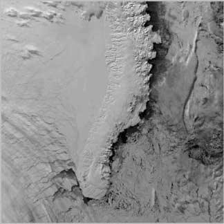
 Envisat-style products for ATSR-1 and ATSR-2 data (Issue 3.0, 29 th January, 2014) 1 The cover picture shows the 11m brightness temperature around the south-west coast of South-Africa as acquired by ATSR-1
MERIS instrument. Muriel Simon, Serco c/o ESA
 MERIS instrument Muriel Simon, Serco c/o ESA Workshop on Sustainable Development in Mountain Areas of Andean Countries Mendoza, Argentina, 26-30 November 2007 ENVISAT MISSION 2 Mission Chlorophyll case
Suomi NPP VIIRS Calibration/ Validation Progress Update
 Suomi NPP VIIRS Calibration/ Validation Progress Update C. Cao 1, Q. Liu 2, S. Blonski 2, X. Shao 2, and S. Uprety 3 1 NOAA/NESDIS Center for Satellite Applications and Research 2 ESSIC, University of
EPS Bridge Low-Cost Satellite
 EPS Bridge Low-Cost Satellite Results of a Concept Study being performed for Dr. Hendrik Lübberstedt OHB-System AG OpSE Workshop Walberberg 8th November 2005 EPS Bridge Key System Requirements Minimum
Compact High Resolution Imaging Spectrometer (CHRIS) siraelectro-optics
 siraelectro-optics") Compact High Resolution Imaging Spectrometer (CHRIS) Mike Cutter (Mike_Cutter@siraeo.co.uk) Summary CHRIS Instrument Design Instrument Specification & Performance Operating Modes Calibration Plan Data
Compact High Resolution Imaging Spectrometer (CHRIS) Mike Cutter (Mike_Cutter@siraeo.co.uk) Summary CHRIS Instrument Design Instrument Specification & Performance Operating Modes Calibration Plan Data
S3 Product Notice SLSTR
 S3 Product Notice SLSTR Mission Sensor Product S3-A SLSTR Level 2 Land Surface Temperature Product Notice ID S3A.PN-SLSTR-L2L.02 Issue/Rev Date 05/07/2017 Version 1.0 Preparation Approval This Product
Kazuhiro TANAKA GCOM project team/jaxa April, 2016
 Kazuhiro TANAKA GCOM project team/jaxa April, 216 @ SPIE Asia-Pacific 216 at New Dehli, India 1 http://suzaku.eorc.jaxa.jp/gcom_c/index_j.html GCOM mission and satellites SGLI specification and IRS overview
NASTER System Definition Proposal
 Remote Sensing Team NASTER System Definition Proposal All rights reserved. - 7/14/03 Page 1 Overview Review and comment the mid-ir requirements Presentation of ABB s current platform technology Proposed
(A)ATSR Third Reprocessing Dataset User Summary
ATSR Third Reprocessing Dataset User Summary") (A)ATSR Third Reprocessing Dataset User Summary Author(s) : IDEAS+ AATSR QC Team (Telespazio VEGA UK) This document contains key information for users concerning the (A)ATSR Third Reprocessing dataset;
(A)ATSR Third Reprocessing Dataset User Summary Author(s) : IDEAS+ AATSR QC Team (Telespazio VEGA UK) This document contains key information for users concerning the (A)ATSR Third Reprocessing dataset;
The Global Imager (GLI)
") The Global Imager (GLI) Launch : Dec.14, 2002 Initial check out : to Apr.14, 2003 (~L+4) First image: Jan.25, 2003 Second image: Feb.6 and 7, 2003 Calibration and validation : to Dec.14, 2003(~L+4) for
The Global Imager (GLI) Launch : Dec.14, 2002 Initial check out : to Apr.14, 2003 (~L+4) First image: Jan.25, 2003 Second image: Feb.6 and 7, 2003 Calibration and validation : to Dec.14, 2003(~L+4) for
Calibration and In-Flight Performance of the Sentinel-3 Sea and Land Surface Temperature Radiometer
 Calibration and In-Flight Performance of the Sentinel-3 Sea and Land Surface Temperature Radiometer Dave Smith; Arrow Lee; Mireya Extaluze; Edward Polehampton; Tim Nightingale; Elliot Newman; Dan Peters
Copernicus Introduction Lisbon, Portugal 13 th & 14 th February 2014
 Copernicus Introduction Lisbon, Portugal 13 th & 14 th February 2014 Contents Introduction GMES Copernicus Six thematic areas Infrastructure Space data An introduction to Remote Sensing In-situ data Applications
The AATSR LST retrieval: State of knowledge and current developments
 The AATSR LST retrieval: State of knowledge and current developments Darren Ghent, Ed Comyn-Platt, Gary Corlett, David Llewellyn-Jones, Harjinder Sembhi, Karen Veal, Christopher Whyte and John Remedios
METimage Calibration & Performance Verification. Xavier Gnata ICSO 2016
 METimage Calibration & Performance Verification Xavier Gnata ICSO 2016 METimage factsheet Mission Passive imaging radiometer (multi-spectral) 20 spectral channels (443 13.345nm) Global coverage within
Multispectral Scanners for Wildland Fire Assessment NASA Ames Research Center Earth Science Division. Bruce Coffland U.C.
 Multispectral Scanners for Wildland Fire Assessment NASA Earth Science Division Bruce Coffland U.C. Santa Cruz Slide Fire Burn Area (MASTER/B200) R 2.2um G 0.87um B 0.65um Airborne Science & Technology
LWIR NUC Using an Uncooled Microbolometer Camera
 LWIR NUC Using an Uncooled Microbolometer Camera Joe LaVeigne a, Greg Franks a, Kevin Sparkman a, Marcus Prewarski a, Brian Nehring a, Steve McHugh a a Santa Barbara Infrared, Inc., 30 S. Calle Cesar Chavez,
THE SPACE TECHNOLOGY RESEARCH VEHICLE 2 MEDIUM WAVE INFRA RED IMAGER
 THE SPACE TECHNOLOGY RESEARCH VEHICLE 2 MEDIUM WAVE INFRA RED IMAGER S J Cawley, S Murphy, A Willig and P S Godfree Space Department The Defence Evaluation and Research Agency Farnborough United Kingdom
IDEAS+ WP3520 Calibration and data quality toolbox. July 2016 Steve Mackin James Warner
 IDEAS+ WP3520 Calibration and data quality toolbox July 2016 Steve Mackin James Warner Proposition : Every image contains the same information Railroad Valley, Nevada London, UK Rationale for the project
ENVISAT AATSR Instrument Performance - End of Mission Report
 Report Doc No: PO-RP-RAL-AT-0621 Issue: 1.0 Date: 08-Oct-2012 Page: 1 of 69 ENVISAT AATSR Instrument Performance - End of Mission Report Prepared by: Checked By: Project Management: D.L. Smith J.A. Abolins
CIRiS: Compact Infrared Radiometer in Space August, 2017
 1 CIRiS: Compact Infrared Radiometer in Space August, 2017 David Osterman PI, CIRiS Mission Presented by Hansford Cutlip 10/8/201 7 Overview of the CIRiS instrument and mission The CIRiS instrument is
THE MIAMI-2001 RADIOMETER INTERCOMPARISON
 ABSTRACT THE MIAMI-2001 RADIOMETER INTERCOMPARISON P. J. Minnett (1), I. J. Barton (2), J. P. Rice (3) (1) Rosenstiel School of Marine and Atmospheric Science, University of Miami, Florida, USA. Email:
AMIPAS. Advanced Michelson Interferometer for Passive Atmosphere Sounding. Concepts and Technology for Future Atmospheric Chemistry Sensors
 Earth Observation, Navigation & Science Concepts and Technology for Future Atmospheric Chemistry Sensors AMIPAS Advanced Michelson Interferometer for Passive Atmosphere Sounding Markus Melf, Winfried Posselt,
Sentinel-3 OLCI and SLSTR
 Sentinel-3 OLCI and SLSTR Craig Donlon ESA/ESTEC, Mission Science Division B. Berruti, J. Frerick, C. Mavrocordatos, J. Nieke, H. Rebhan, J. Stroede and the S3 Team, European Space Agency, ESTEC, Keplerlaan
National Remote Sensing Centre Limited ERS ALONG TRACK SCANNING RADIOMETER ATS.GBT PRODUCT USER GUIDE
 National Remote Sensing Centre Limited ERS ALONG TRACK SCANNING RADIOMETER ATS.GBT PRODUCT USER GUIDE ISSUE 1.4 19 March 1998 Prepared for The United Kingdom Processing and Archiving Facility By National
GOES-16 ABI On-Orbit Performance
 GOES-16 ABI On-Orbit Performance Xiangqian WU b, Fangfang YU a, Vladimir KONDRATOVICH a, Boryana EFREMOVA a, Xi SHAO a, Robert IACOVAZZI a, Haifeng QIAN a, Hye Lim YOO a, Li ZHU a, and Changyong CAO b
Japanese Advanced Meteorological Imager: A Next Generation GEO Imager for MTSAT-1R
 Japanese Advanced Meteorological Imager: A Next Generation GEO Imager for MTSAT-1R Jeffery J. Puschell 1 Raytheon Electronic Systems, Santa Barbara Remote Sensing ABSTRACT The Japanese Advanced Meteorological
AVHRR/3 Operational Calibration
 AVHRR/3 Operational Calibration Jörg Ackermann, Remote Sensing and Products Division 1 Workshop`Radiometric Calibration for European Missions, 30/31 Aug. 2017`,Frascati (EUM/RSP/VWG/17/936014) AVHRR/3
NON-PHOTOGRAPHIC SYSTEMS: Multispectral Scanners Medium and coarse resolution sensor comparisons: Landsat, SPOT, AVHRR and MODIS
 NON-PHOTOGRAPHIC SYSTEMS: Multispectral Scanners Medium and coarse resolution sensor comparisons: Landsat, SPOT, AVHRR and MODIS CLASSIFICATION OF NONPHOTOGRAPHIC REMOTE SENSORS PASSIVE ACTIVE DIGITAL
Radiometric performance of Second Generation Global Imager (SGLI) using integrating sphere
 using integrating sphere") Radiometric performance of Second Generation Global Imager (SGLI) using integrating sphere Taichiro Hashiguchi, Yoshihiko Okamura, Kazuhiro Tanaka, Yukinori Nakajima Japan Aerospace Exploration Agency
Radiometric performance of Second Generation Global Imager (SGLI) using integrating sphere Taichiro Hashiguchi, Yoshihiko Okamura, Kazuhiro Tanaka, Yukinori Nakajima Japan Aerospace Exploration Agency
Lecture 6: Multispectral Earth Resource Satellites. The University at Albany Fall 2018 Geography and Planning
 Lecture 6: Multispectral Earth Resource Satellites The University at Albany Fall 2018 Geography and Planning Outline SPOT program and other moderate resolution systems High resolution satellite systems
RADIATION BUDGET INSTRUMENT (RBI): FINAL DESIGN AND INITIAL EDU TEST RESULTS
: FINAL DESIGN AND INITIAL EDU TEST RESULTS") Place image here (10 x 3.5 ) RADIATION BUDGET INSTRUMENT (RBI): FINAL DESIGN AND INITIAL EDU TEST RESULTS RONALD GLUMB, JAY OVERBECK, CHRISTOPHER LIETZKE, JOHN FORSYTHE, ALAN BELL, AND JASON MILLER NON-EXPORT
Place image here (10 x 3.5 ) RADIATION BUDGET INSTRUMENT (RBI): FINAL DESIGN AND INITIAL EDU TEST RESULTS RONALD GLUMB, JAY OVERBECK, CHRISTOPHER LIETZKE, JOHN FORSYTHE, ALAN BELL, AND JASON MILLER NON-EXPORT
9/12/2011. Training Course Remote Sensing Basic Theory & Image Processing Methods September 2011
 Training Course Remote Sensing Basic Theory & Image Processing Methods 19 23 September 2011 Popular Remote Sensing Sensors & their Selection Michiel Damen (September 2011) damen@itc.nl 1 Overview Low resolution
STATUS OF THE SEVIRI LEVEL 1.5 DATA
 STATUS OF THE SEVIRI LEVEL 1.5 DATA Christopher Hanson (1), Johannes Mueller (1) EUMETSAT, Am Kavalleriesand 31, D-64295 Darmstadt, Germany, Email: hanson@eumetsat.de (2) VEGA IT GmbH, Hilpertstraβe, 20A,
Sentinel-2 Products and Algorithms
 Sentinel-2 Products and Algorithms Ferran Gascon (Sentinel-2 Data Quality Manager) Workshop Preparations for Sentinel 2 in Europe, Oslo 26 November 2014 Sentinel-2 Mission Mission Overview Products and
Large format 17µm high-end VOx µ-bolometer infrared detector
 Large format 17µm high-end VOx µ-bolometer infrared detector U. Mizrahi, N. Argaman, S. Elkind, A. Giladi, Y. Hirsh, M. Labilov, I. Pivnik, N. Shiloah, M. Singer, A. Tuito*, M. Ben-Ezra*, I. Shtrichman
On-Orbit Radiometric Performance of the Landsat 8 Thermal Infrared Sensor. External Editors: James C. Storey, Ron Morfitt and Prasad S.
 Remote Sens. 2014, 6, 11753-11769; doi:10.3390/rs61211753 OPEN ACCESS remote sensing ISSN 2072-4292 www.mdpi.com/journal/remotesensing Article On-Orbit Radiometric Performance of the Landsat 8 Thermal
Infrared filters and dichroics for the advanced along-track scanning radiometer
 Infrared filters and dichroics for the advanced along-track scanning radiometer Roger Hunneman and Gary Hawkins The design and manufacture of the band-defining filters and their associated dichroic beam
Use of Drifting Buoy SST in Remote Sensing. Chris Merchant University of Edinburgh Gary Corlett University of Leicester
 Use of Drifting Buoy SST in Remote Sensing Chris Merchant University of Edinburgh Gary Corlett University of Leicester Three decades of AVHRR SST Empirical regression to buoy SSTs to define retrieval Agreement
IASI on METOP On-Ground Calibration of the FM2 Instrument
 Infrared Atmospheric Sounding Interferometer IASI on METOP On-Ground Calibration of the FM2 Instrument International TOVS Study Conference 25-31, May 2005 Beijing China D. Blumstein 1,B.Tournier 2, T.Carlier
Recent developments in Deep Blue satellite aerosol data products from NASA GSFC
 Recent developments in Deep Blue satellite aerosol data products from NASA GSFC Andrew M. Sayer, N. Christina Hsu (PI), Corey Bettenhausen, Myeong-Jae Jeong Climate & Radiation Laboratory, NASA Goddard
NIRST, a satellite based IR instrument for fire and sea surface temperature measurement
 NIRST, a satellite based IR instrument for fire and sea surface temperature measurement Hugo Marraco a and Linh Ngo Phong b a Comisión Nacional de Actividades Espaciales, Paseo Colón 751, C1063ACH Buenos
On the use of water color missions for lakes in 2021
 Lakes and Climate: The Role of Remote Sensing June 01-02, 2017 On the use of water color missions for lakes in 2021 Cédric G. Fichot Department of Earth and Environment 1 Overview 1. Past and still-ongoing
GeoSTAR A New Approach for a Geostationary Microwave Sounder
 GeoSTAR A New Approach for a Geostationary Microwave Sounder Bjorn Lambrigtsen 13th International TOVS Study Jet Propulsion Laboratory California Institute of Technology Conference Ste. Adèle, Canada October
CCDs for Earth Observation James Endicott 1 st September th UK China Workshop on Space Science and Technology, Milton Keynes, UK
 CCDs for Earth Observation James Endicott 1 st September 2011 7 th UK China Workshop on Space Science and Technology, Milton Keynes, UK Introduction What is this talk all about? e2v sensors in spectrometers
ASSESSMENT BY ESA OF GCOS CLIMATE MONITORING PRINCIPLES FOR GMES
 Prepared by ESA Agenda Item: III.5 Discussed in WG3 ASSESSMENT BY ESA OF GCOS CLIMATE MONITORING PRINCIPLES FOR GMES The ESA Sentinel missions are being designed for the GMES services, with special emphasis
Performance status of IASI on MetOp-A and MetOp-B
 Performance status of IASI on MetOp-A and MetOp-B E. Jacquette (1), E. Péquignot (1), J. Chinaud (1), C. Maraldi (1), D. Jouglet (1), S. Gaugain (1), L. Buffet (1), C. Villaret (1), C. Larigauderie (1),
Multi-sensor data base over desert sites for calibration purpose. P. Henry ¹, X. Briottet ², C. Miesch ², F. Cabot ¹ ¹CNES, ²ONERA
 Multi-sensor data base over desert sites for calibration purpose P. Henry ¹, X. Briottet ², C. Miesch ², F. Cabot ¹ ¹CNES, ²ONERA Outline Introduction SADE database Calibration method Some results Desert
AN INTRODUCTION TO MICROCARB, FIRST EUROPEAN PROGRAM FOR CO2 MONITORING.
 AN INTRODUCTION TO MICROCARB, FIRST EUROPEAN PROGRAM FOR CO2 MONITORING. International Working Group on Green house Gazes Monitoring from Space IWGGMS-12 Francois BUISSON CNES With Didier PRADINES, Veronique
Hyperspectral Systems: Recent Developments and Low Cost Sensors. 56th Photogrammetric Week in Stuttgart, September 11 to September 15, 2017
 Hyperspectral Systems: Recent Developments and Low Cost Sensors 56th Photogrammetric Week in Stuttgart, September 11 to September 15, 2017 Ralf Reulke Humboldt-Universität zu Berlin Institut für Informatik,
MERIS US Workshop. Instrument Overview. Steven Delwart
 MERIS US Workshop Instrument Overview Steven Delwart ENVISAT Acknowledgement To the ENVISAT Team & MERIS Instrument Engineers Jean-Loup Bezy George Gourmelon ENVISAT- MERIS 120M 200 Kg 1m 3 175 W MERIS
CHAPTER --'3 DATA DESCRIPTION
 CHAPTER --'3 DATA DESCRIPTION 37 3.1 INTRODUCTION In chapter 2 different techniques used for the study of polar cryosphere like passive and active remote sensing, altimetry and scatterometry are described.
VIIRS Cloud-Free Compositing For Nighttime Lights
 VIIRS Cloud-Free Compositing For Nighttime Lights Kimberly Baugh, CIRES University of Colorado Feng Chi Hsu, CIRES University of Colorado Mikhail Zhizhin, CIRES University of Colorado Tilottama Ghosh,
Advanced Meteorological Imager (AMI) Development for GEO-KOMPSAT-2A
 Development for GEO-KOMPSAT-2A") 1 st KMA International Meteorological Satellite Conference Advanced Meteorological Imager (AMI) Development for GEO-KOMPSAT-2A 16 November 2015 Koon-Ho YANG Korea Aerospace Research Institute 1 Agenda
1 st KMA International Meteorological Satellite Conference Advanced Meteorological Imager (AMI) Development for GEO-KOMPSAT-2A 16 November 2015 Koon-Ho YANG Korea Aerospace Research Institute 1 Agenda
SATELLITE OCEANOGRAPHY
 SATELLITE OCEANOGRAPHY An Introduction for Oceanographers and Remote-sensing Scientists I. S. Robinson Lecturer in Physical Oceanography Department of Oceanography University of Southampton JOHN WILEY
Japanese Advanced Meteorological Imager
 Japanese Advanced Meteorological Imager Jeffery J. Puschell Raytheon Space and Airborne Systems 2000 East El Segundo Boulevard, EO/E01/C150 El Segundo, CA 90245-0902 UNITED STATES OF AMERICA Abstract:
LSST All-Sky IR Camera Cloud Monitoring Test Results
 LSST All-Sky IR Camera Cloud Monitoring Test Results Jacques Sebag a, John Andrew a, Dimitri Klebe b, Ronald D. Blatherwick c a National Optical Astronomical Observatory, 950 N Cherry, Tucson AZ 85719
Two-linear-polarization measurement of O 2 A band with TANSO-FTS onboard GOSAT
 Remote sensing in the O 2 A band Two-linear-polarization measurement of O 2 A band with TANSO-FTS onboard GOSAT July 7, 2016, De Bilt Akihiko Kuze, Hiroshi Suto, Kei Shiomi, Nobuhiro Kikuchi, Makiko Hashimoto
Sub-Mesoscale Imaging of the Ionosphere with SMAP
 Sub-Mesoscale Imaging of the Ionosphere with SMAP Tony Freeman Xiaoqing Pi Xiaoyan Zhou CEOS Workshop, ASF, Fairbanks, Alaska, December 2009 1 Soil Moisture Active-Passive (SMAP) Overview Baseline Mission
Lecture Notes Prepared by Prof. J. Francis Spring Remote Sensing Instruments
 Lecture Notes Prepared by Prof. J. Francis Spring 2005 Remote Sensing Instruments Material from Remote Sensing Instrumentation in Weather Satellites: Systems, Data, and Environmental Applications by Rao,
High Dynamic Range Imaging using FAST-IR imagery
 High Dynamic Range Imaging using FAST-IR imagery Frédérick Marcotte a, Vincent Farley* a, Myron Pauli b, Pierre Tremblay a, Martin Chamberland a a Telops Inc., 100-2600 St-Jean-Baptiste, Québec, Qc, Canada,
Sentinel-3 OLCI/SLSTR - Validation of the Radiometric Calibration for Optical Sensors
 Sentinel-3 OLCI/SLSTR - Validation of the Radiometric Calibration for Optical Sensors Bertrand Fougnie Centre national d Etudes Spatiales, 31404 Toulouse, France (@cnes.fr) Jens Nieke, Marc Bouvet European
Project Title: Validation and Correction for the MODIS Spatial Response. NASA Grant #: NAG Period: October 1, May 31, 1999
 Project Title: Validation and Correction for the MODIS Spatial Response NASA Grant #: NAG5 6339 Period: October 1, 1997 - May 31, 1999 Robert A. Schowengerdt, Principal Investigator Stuart E. Biggar, Co
Demonstration of Two-Stage Temperature Control for Raytheon Hybrid Cryocoolers
 1 Demonstration of Two-Stage Temperature Control for Raytheon Hybrid Cryocoolers T. Conrad, B. Schaefer, D. Kuo, D. Bruckman, M. Kieffer, R. Yates Raytheon Space and Airborne Systems El Segundo, CA 90025
TerraSAR-X Calibration Status 2 Years in Flight
 2 Years in Flight Dirk Schrank, Marco Schwerdt, Markus Bachmann, Björn Döring, Clemens Schulz November 2009 CEOS 09 VG 1 Calibration Tasks Performed 2009 Introduction Challenge Schedule Re-Calibration
measurements from each beam are kept separate. We note that the variation in incidence angle over an orbit is small, typically less than a few tenths
 A QuikScat/SeaWinds Sigma-0 Browse Product David G. Long Microwave Earth Remote Sensing Laboratory BYU Center for Remote Sensing Brigham Young University 459 Clyde Building, Provo, UT 84602 long@ee.byu.edu
RECONNAISSANCE PAYLOADS FOR RESPONSIVE SPACE
 3rd Responsive Space Conference RS3-2005-5004 RECONNAISSANCE PAYLOADS FOR RESPONSIVE SPACE Charles Cox Stanley Kishner Richard Whittlesey Goodrich Optical and Space Systems Division Danbury, CT Frederick
Lecture 2. Electromagnetic radiation principles. Units, image resolutions.
 NRMT 2270, Photogrammetry/Remote Sensing Lecture 2 Electromagnetic radiation principles. Units, image resolutions. Tomislav Sapic GIS Technologist Faculty of Natural Resources Management Lakehead University
Radiometric Solar Telescope (RaST) The case for a Radiometric Solar Imager,
 The case for a Radiometric Solar Imager,") SORCE Science Meeting 29 January 2014 Mark Rast Laboratory for Atmospheric and Space Physics University of Colorado, Boulder Radiometric Solar Telescope (RaST) The case for a Radiometric Solar Imager,
SORCE Science Meeting 29 January 2014 Mark Rast Laboratory for Atmospheric and Space Physics University of Colorado, Boulder Radiometric Solar Telescope (RaST) The case for a Radiometric Solar Imager,
Changyong Cao 1, Pubu Ciren 2, Mitch Goldberg 1, and Fuzhong Weng 1. Introduction
 Intersatellite Calibration of HIRS from 1980 to 2003 Using the Simultaneous Nadir Overpass (SNO) Method for Improved Consistency and Quality of Climate Data Changyong Cao 1, Pubu Ciren 2, Mitch Goldberg
Status of Aqua MODIS Reflective Solar Bands Calibration and Performance
 EOS Status of Aqua MODIS Reflective Solar Bands Calibration and Performance Jack Xiong NASA GSFC, Greenbelt, MD 20771, USA A. Angal, H. Chen, X. Geng, D. Link, Y. Li, and A. Wu SSAI, 10210 Greenbelt Road,
GPI INSTRUMENT PAGES
 GPI INSTRUMENT PAGES This document presents a snapshot of the GPI Instrument web pages as of the date of the call for letters of intent. Please consult the GPI web pages themselves for up to the minute
Fiducial Reference Measurement for Cal/Val
 Fiducial Reference Measurement for Cal/Val Philippe Goryl Sensor Performance Product Algorithm ESA/ESRIN Issue/Revision: 0.0 Reference: Status: ESA UNCLASSIFIED - For Official Use Copernicus European Leadership
Remote Sensing for Resource Management
 Remote Sensing for Resource Management Ebenezer Nyadjro US Naval Research Lab/UNO RMU Summer Program (July 31-AUG 4, 2017) Motivation Polluted Pra River Motivation. 3 Motivation Polluted Pra River Motivation.
Some Basic Concepts of Remote Sensing. Lecture 2 August 31, 2005
 Some Basic Concepts of Remote Sensing Lecture 2 August 31, 2005 What is remote sensing Remote Sensing: remote sensing is science of acquiring, processing, and interpreting images and related data that
Evaluation of FLAASH atmospheric correction. Note. Note no SAMBA/10/12. Authors. Øystein Rudjord and Øivind Due Trier
 Evaluation of FLAASH atmospheric correction Note Note no Authors SAMBA/10/12 Øystein Rudjord and Øivind Due Trier Date 16 February 2012 Norsk Regnesentral Norsk Regnesentral (Norwegian Computing Center,
Cross Track Infrared Sounder (CrIS) Flight Model 1 Test Results
 Flight Model 1 Test Results") May 6, 2009 Ronald Glumb, Joseph P. Predina, Robert Hookman, Chris Ellsworth, John Bobilya, Steve Wells, Lawrence Suwinski, Rebecca Frain, and Larry Crawford For Publication at the ASS-FTS14 Conference
May 6, 2009 Ronald Glumb, Joseph P. Predina, Robert Hookman, Chris Ellsworth, John Bobilya, Steve Wells, Lawrence Suwinski, Rebecca Frain, and Larry Crawford For Publication at the ASS-FTS14 Conference
ECE 583. Lecture 27 Imaging Visible and Infrared Radiometers. Array Detector Imagers Stereo Cloud Hieght & Winds Application
 ECE 583 Lecture 27 Imaging Visible and Infrared Radiometers Array Detector Imagers Stereo Cloud Hieght & Winds Application Why remote sensing - Much of the atmosphere is inaccessible, at least for routine
Fundamentals of Remote Sensing
 Climate Variability, Hydrology, and Flooding Fundamentals of Remote Sensing May 19-22, 2015 GEO-Latin American & Caribbean Water Cycle Capacity Building Workshop Cartagena, Colombia 1 Objective To provide
Design of a Free Space Optical Communication Module for Small Satellites
 Design of a Free Space Optical Communication Module for Small Satellites Ryan W. Kingsbury, Kathleen Riesing Prof. Kerri Cahoy MIT Space Systems Lab AIAA/USU Small Satellite Conference August 6 2014 Problem
Microwave Sensors Subgroup (MSSG) Report
 Report") Microwave Sensors Subgroup (MSSG) Report CEOS WGCV-35 May 13-17, 2013, Shanghai, China DONG, Xiaolong, MSSG Chair CAS Key Laboratory of Microwave Remote Sensing National Space Science Center Chinese Academy
Microwave Sensors Subgroup (MSSG) Report CEOS WGCV-35 May 13-17, 2013, Shanghai, China DONG, Xiaolong, MSSG Chair CAS Key Laboratory of Microwave Remote Sensing National Space Science Center Chinese Academy
European Space Agency and IPY
 European Space Agency and IPY ESA supports IPY 2007-2008 activities: First ESA step was a dedicated Announcement Opportunity (AO) for EO data provision in support IPY, released in 2006, with data provision
METimage an innovative imaging radiometer for Post-EPS
 METimage an innovative imaging radiometer for Post-EPS Dr. Christian Brüns 1, Dr. Matthias Alpers 1, Dr. Alexander Pillukat 2 1 DLR German Space Agency, Königswinterer Straße 522-524, D-53227 Bonn, Germany
CHARACTERISTICS OF REMOTELY SENSED IMAGERY. Radiometric Resolution
 CHARACTERISTICS OF REMOTELY SENSED IMAGERY Radiometric Resolution There are a number of ways in which images can differ. One set of important differences relate to the various resolutions that images express.
Status of Meteosat Third Generation (MTG) Pre-Phase A System Architecture Studies
 Pre-Phase A System Architecture Studies") Status of Meteosat Third Generation (MTG) Pre-Phase A System Architecture Studies Paolo Bensi, Earth Observation Future Programme Department European Space Agency Planning: Meteosat Third Generation (MTG)
Status of Meteosat Third Generation (MTG) Pre-Phase A System Architecture Studies Paolo Bensi, Earth Observation Future Programme Department European Space Agency Planning: Meteosat Third Generation (MTG)
Satellite/Aircraft Imaging Systems Imaging Sensors Standard scanner designs Image data formats
 CEE 6150: Digital Image Processing 1 Satellite/Aircraft Imaging Systems Imaging Sensors Standard scanner designs Image data formats CEE 6150: Digital Image Processing 2 CEE 6150: Digital Image Processing
CONTRIBUTION OF THE IMS GLOBAL NETWORK OF HYDROACOUSTIC STATIONS FOR MONITORING THE CTBT PAULINA BITTNER, EZEKIEL JONATHAN, MARCELA VILLARROEL
 CONTRIBUTION OF THE IMS GLOBAL NETWORK OF HYDROACOUSTIC STATIONS FOR MONITORING THE CTBT PAULINA BITTNER, EZEKIEL JONATHAN, MARCELA VILLARROEL Provisional Technical Secretariat of the Preparatory Commission
ENMAP RADIOMETRIC INFLIGHT CALIBRATION, POST-LAUNCH PRODUCT VALIDATION, AND INSTRUMENT CHARACTERIZATION ACTIVITIES
 ENMAP RADIOMETRIC INFLIGHT CALIBRATION, POST-LAUNCH PRODUCT VALIDATION, AND INSTRUMENT CHARACTERIZATION ACTIVITIES A. Hollstein1, C. Rogass1, K. Segl1, L. Guanter1, M. Bachmann2, T. Storch2, R. Müller2,
746A27 Remote Sensing and GIS. Multi spectral, thermal and hyper spectral sensing and usage
 746A27 Remote Sensing and GIS Lecture 3 Multi spectral, thermal and hyper spectral sensing and usage Chandan Roy Guest Lecturer Department of Computer and Information Science Linköping University Multi
OVERVIEW OF KOMPSAT-3A CALIBRATION AND VALIDATION
 OVERVIEW OF KOMPSAT-3A CALIBRATION AND VALIDATION DooChun Seo 1, GiByeong Hong 1, ChungGil Jin 1, DaeSoon Park 1, SukWon Ji 1 and DongHan Lee 1 1 KARI(Korea Aerospace Space Institute), 45, Eoeun-dong,
Advanced Radiometer for Sea Surface Temperature Observations
 Advanced Radiometer for Sea Surface Temperature Observations Harp Technologies Oy: J. Kainulainen, J. Uusitalo, J. Lahtinen TERMA A/S: M. Hansen, M. Pedersen Finnish Remote Sensing Days 2014 Finnish Meteorological
MSPI: The Multiangle Spectro-Polarimetric Imager
 MSPI: The Multiangle Spectro-Polarimetric Imager I. Summary Russell A. Chipman Professor, College of Optical Sciences University of Arizona (520) 626-9435 rchipman@optics.arizona.edu The Multiangle SpectroPolarimetric
SMOS mission: a new way for monitoring Sea Surface Salinity?
 SMOS mission: a new way for monitoring Sea Surface Salinity? J. Boutin (1) (1) Laboratoire d Oceanographie et du Climat- Expérimentation et Applications Numériques (LOCEAN), PARIS, FRANCE Thanks to T.
SIRAS-G, The Spaceborne Infrared Atmospheric Sounder: The Potential for High-Resolution IR Imaging Spectrometry From Geosynchronous Orbit
 SIRAS-G, The Spaceborne Infrared Atmospheric Sounder: The Potential for High-Resolution IR Imaging Spectrometry From Geosynchronous Orbit Thomas U. Kampe Ball Aerospace & Technologies Corp. 1600 Commerce
Sub-system and System Level Testing and Calibration of Space Altimeters and LIDARS.
 Sub-system and System Level Testing and Calibration of Space Altimeters and LIDARS. Haris Riris, Pete Liiva, Xiaoli Sun, James Abshire Laser Remote Sensing Branch Goddard Space Flight Center, Greenbelt,
NOAA EON-IR CubeSat Study for Operational Infrared Soundings
 NOAA EON-IR CubeSat Study for Operational Infrared Soundings Dan Mamula National Oceanic and Atmospheric Administration National Environmental Satellite, Data, and Information Service Office of Project,
John P. Stevens HS: Remote Sensing Test
 Name(s): Date: Team name: John P. Stevens HS: Remote Sensing Test 1 Scoring: Part I - /18 Part II - /40 Part III - /16 Part IV - /14 Part V - /93 Total: /181 2 I. History (3 pts. each) 1. What is the name
The Sounding Instruments on Second Generation of Chinese Meteorological Satellite FY-3
 The Sounding Instruments on Second Generation of Chinese Meteorological Satellite FY-3 DONG Chaohua ZHANG Wenjian National Satellite Meteorological Center China Meteorological Administration Beijing 100081,
Spectral Signatures. Vegetation. 40 Soil. Water WAVELENGTH (microns)
") Spectral Signatures % REFLECTANCE VISIBLE NEAR INFRARED Vegetation Soil Water.5. WAVELENGTH (microns). Spectral Reflectance of Urban Materials 5 Parking Lot 5 (5=5%) Reflectance 5 5 5 5 5 Wavelength (nm)
Spectral Signatures % REFLECTANCE VISIBLE NEAR INFRARED Vegetation Soil Water.5. WAVELENGTH (microns). Spectral Reflectance of Urban Materials 5 Parking Lot 5 (5=5%) Reflectance 5 5 5 5 5 Wavelength (nm)
HYPERCUBE: Hyperspectral Imaging Using a CUBESAT
 HYPERCUBE: Hyperspectral Imaging Using a CUBESAT Ian S. Robinson Senior Engineering Fellow Raytheon Certified Architect Ian.Robinson@Raytheon.com Customer Success Is Our Mission Copyright 2011 Raytheon