RADIOMETRIC CALIBRATION
|
|
|
- Julie Tucker
- 5 years ago
- Views:
Transcription
1 1 RADIOMETRIC CALIBRATION Lecture 10
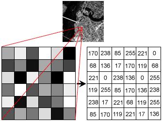
2 Digital Image Data 2 Digital data are matrices of digital numbers (DNs) There is one layer (or matrix) for each satellite band Each DN corresponds to one pixel
3 3
4 Digital Image Data 4 Images are presented as 2-d arrays. Each pixel (array element) has a location (x,y) and associated with it a digital number (DN). Position of pixel often describe in terms of rows and columns F(2,3) F(4,1)
5 What are digital numbers (DNs)? 5 DNs are relative measures of radiance DNs are NOT reflectance DNs can be converted to ground reflectance if we know atmospheric properties, etc. The range of DNs depends on the radiometric resolution of the instrument
6 Landsat Group 6 Rescaling factors for converting calibrated Digital Numbers (DNs) to absolute units at-sensor radiance The Landsat series of satellite provides longest continuous record of satellitebased observation Landsat satellite can be classified into 3 groups based on sensor and platform characteristics : Gr. 1 Landsat 1, Landsat 2, Landsat 3 with the Multispectral Sacnner (MSS) sensor and the Return Beam Vidicon (RBV) camera Gr. 2 Landsat 4, Landsat 5 which carry the Thematic Mapper (TM) as well as the MSS sensor Gr. 3 Landsat 6 and Landsat 7 which include the Enhanced Thematic Mapper (ETM) and the Enhanced Thematic Mapper Plus (ETM+) sensors respectively
7 Radiometric calibration 7 The ability to detect and quantify changes on the Earth s environment depends on the sensor that can provide Calibrated and consistent measurement of the Earth s surface The correct interpretation of scientific information from a global, long-term series of RS products requires the ability to discriminate between product artifacts and changes in the Earth processes being monitored.
8 Radiometric calibration 8 In the application of satellite RS data for quantitative investigations, the first and foremost important step are : Calibration of satellite data Atmospheric correction Topographic correction Spectral signatures plays an important role in detecting and analyzing Earth surface Different material types can be spectrally similar making identification and classification difficult Through understanding the limitations and constraints of RS system and its related products is of vital importance
9 Radiometric calibration 9 Radiometric correction applied to digital data varies significantly among sensors. Radiance measured of any object by a RS is influenced by : Bi-directional reflectance distribution (BRDF) Changes in scene illumination Atmospheric attenuation Viewing and topographic geometry Instrument response characteristics
10 Radiometric calibration 10 Various paths of irradiance and surface reflectance can alter the apparent at-sensor radiance of a given target Path radiance Total at-sensor radiance : Diffused radiation Reflected radiation Emitted radiation
11 Conversion to at-sensor spectral radiance (Q cal -to-l λ ) 11 Calculation of at-sensor spectral radiance is the fundamental step in converting image data from multiple sensors and platforms into a physically meaningful common radiometric scale Radiometric calibration of the MSS, TM and ETM+, sensors involves rescaling the raw digital numbers (Q) transmitted from the satellite to calibrated digital numbers (Q cal )
12 Conversion to at-sensor spectral radiance (Q cal -to-l λ ) 12 During calibration the pixel values (Q) from raw, unprocessed image data are converted to units of absolute specatral radiance using 32-bit floating point calculation The absolute values are then scaled to Q cal before media output: 7-bits (MSS, Q calmax =127) 8-bit (TM and ETM+, Q calmax =255) 16-bit (ALI, Q calmax =32767)
13 Conversion to at-sensor spectral radiance (Q cal -to-l λ ) 13 Conversion from Q cal back to at-sensor spectral radiance (L λ ) requires knowledge of the lower and upper limit of the original rescaling factors To convert from Q cal back to L λ then requires knowledge of the original rescaling factors (LMIN λ and LMAX λ ) which have changed over time. Different scaling factors for Landsat 5 and 7
14 Conversion to at-sensor spectral radiance (Q cal -to-l λ ) 14
15 Conversion to at-sensor spectral radiance (Q cal -to-l λ ) 15 Landsat 7, Landsat ETM+ gain data that the satellite can operate under two different gain states (unlike Landsat 5). Gain selection for a scene is controlled by the Mission Operation Center The goal is for maximizing the instrument's 8 bit radiometric resolution without saturating the detectors
16 16 ETM+ Spectral Radiance Range in watts m -2 ster -1 μm -1 Processed Before July 1, 2000 Proccessed After July 1, 2000 Low Gain High Gain Low Gain High Gain LMIN LMAX LMIN LMAX LMIN LMAX LMIN LMAX Band Number
17 Conversion to at-sensor spectral radiance (Q cal -to-l λ ) 17 The gain state for a scene is matched to the expected brightness conditions. For all bands, the low gain dynamic range is approximately 1.5 times the high gain dynamic range hence imaging in low gain mode when surface brightness is high and in high gain mode when surface brightness is low Prior to July 13th, 2000, band 4 always operated in high gain mode when imaging land (land is classified as non-desert and non-ice). After July 13th, 2000, low gain mode was used when sun elevation exceeded 45 and high gain mode continued to be used for land when the sun elevation did not exceed 45
18 18
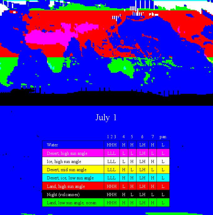
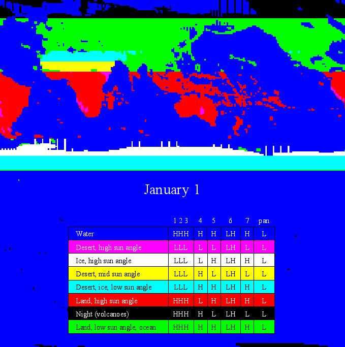
19 ETM+ data characteristics: gain setting 19 Each Landsat-7 Path/Row location is categorized into one of the following six types - for each surface cover type the gain setting rules are different: 1. Land (non-desert, non-ice) 2. Desert 3. Ice/Snow 4. Water 5. Sea Ice 6. Volcano/Night Land (non-desert, non-ice): Bands 1-3 set to high gain Band 4 set to high gain except where sun elevation is greater than 45 to avoid dense vegetation (reflectance > 0.66 ) saturation. (At this sun angle high gain in band 4 saturates at about a reflectance of 0.66, so switching to low gain keeps targets at this reflectance or below from saturating.) Bands 5,7 set to high gain Band 8 set to low gain
20 ETM+ data characteristics: gain setting 20 Desert: Bands 1-3 set to high gain except where sun elevation is greater than 28 - to avoid bright desert target (reflectance >0.65 in band 3, >0.66 in band 1, >0.71 in band 2) saturation Band 4 set to high gain except where sun elevation is greater than 45 (set to low gain) - to avoid bright desert (reflectance > 0.66 ) saturation. Band 5,7 set to high gain except where sun elevation is greater than to avoid bright desert target (reflectance >0.70 in band 5, [>0.68 in band 7] saturation Band 8 set to low gain
21 ETM+ data characteristics: gain setting 21 Ice/Snow and Sea Ice : Bands 1-3 set to high gain except where sun elevation is greater than 19 - to avoid snow ice (reflectance > 0.95 in band 3, >0.94 in band 1, >1.03 in band 2) saturation. Band 4 set to high gain except where sun elevation is greater than 31 - to avoid snow/ice (reflectance >0.92) saturation. Band 5, 7 set to high gain Band 8 set to low gain Water/Coral Reefs : Bands 1-5,7 set to high gain Bands 8 set to low gain Volcano/Night night time imaging (sun elevation < 0) is only routinely performed for sights identified as "Volcano : Bands 1-4, set to high gain Bands 5,7 set to low gain to reduce saturation of volcanic hot spots Band 8 set to low gain
22 ETM+ data characteristics: gain setting 22
23 Conversion of radiance to reflectance (L λ to- ρλ) 23 For relatively clear Landsat scenes, a reduction in between-scene variability can be achieved through a normalization for solar irradiance by converting spectral radiance, as calculated above, to planetary reflectance or albedo. This combined surface and atmospheric reflectance of the Earth is computed with the following formula: 2. L. d p Where: E SUN.cos s p E SUN d L θ s = Unitless planetary reflectance = Mean solar exoatmospheric irradiances (Global flux) [W/(m 2 μm)] = Earth-Sun distance in astronomical units = Spectral radiance at the sensor's aperture [W/(m 2 sr μm)] = Solar zenith angle in degrees

24 Day of Year Distance Day of Year Distance Day of Year Distance Day of Year Distance Day of Year Distance
25 Conversion to at-sensor brightness temperature (L λ -to- T) 25 The thermal band data (Band 6 on TM and ETM+) can be converted from at-sensor spectral radiance to effective at-sensor brightness temperature. The at-sensor brightness temperature assumes that the Earth s surface is a black body (i.e., spectral emissivity is 1), and includes atmospheric effects (absorption and emissions along path). The at-sensor temperature uses the prelaunch calibration constants
26 Conversion to at-sensor brightness temperature (L λ -to- T) 26 The conversion formula from the at-sensor s spectral radiance to at-sensor brightness temperature is:
27 Conversion to at-sensor brightness temperature (L λ -to- T) 27 The ETM+ Level 1 product has two thermal bands: one acquired using a low gain setting (often referred to as Band 6L; useful temperature range of K) other using a high gain setting (often referred to as Band 6H; useful temperature range of K).
MRLC 2001 IMAGE PREPROCESSING PROCEDURE
 MRLC 2001 IMAGE PREPROCESSING PROCEDURE The core dataset of the MRLC 2001 database consists of Landsat 7 ETM+ images. Image selection is based on vegetation greenness profiles defined by a multi-year normalized
Revised Landsat 5 TM Radiometric Calibration Procedures and Post-Calibration Dynamic Ranges
 1 Revised Landsat 5 TM Radiometric Calibration Procedures and Post-Calibration Dynamic Ranges Gyanesh Chander (SAIC/EDC/USGS) Brian Markham (LPSO/GSFC/NASA) Abstract: Effective May 5, 2003, Landsat 5 (L5)
Satellite Remote Sensing: Earth System Observations
 Satellite Remote Sensing: Earth System Observations Land surface Water Atmosphere Climate Ecosystems 1 EOS (Earth Observing System) Develop an understanding of the total Earth system, and the effects of
GeoEye-1 Radiance at Aperture and Planetary Reflectance
 GeoEye-1 Radiance at Aperture and Planetary Reflectance Nancy E. Podger, William B. Colwell, Martin H. Taylor 1 GeoEye-1 Radiance at Aperture and Planetary Reflectance Nancy E. Podger, William B. Colwell,
Int n r t o r d o u d c u ti t on o n to t o Remote Sensing
 Introduction to Remote Sensing Definition of Remote Sensing Remote sensing refers to the activities of recording/observing/perceiving(sensing)objects or events at far away (remote) places. In remote sensing,
Sommersemester Prof. Dr. Christoph Kleinn Institut für Waldinventur und Waldwachstum Arbeitsbereich Fernerkundung und Waldinventur.
 Basics of Remote Sensing Some literature references Franklin, SE 2001 Remote Sensing for Sustainable Forest Management Lewis Publishers 407p Lillesand, Kiefer 2000 Remote Sensing and Image Interpretation
REMOTE SENSING. Topic 10 Fundamentals of Digital Multispectral Remote Sensing MULTISPECTRAL SCANNERS MULTISPECTRAL SCANNERS
 REMOTE SENSING Topic 10 Fundamentals of Digital Multispectral Remote Sensing Chapter 5: Lillesand and Keifer Chapter 6: Avery and Berlin MULTISPECTRAL SCANNERS Record EMR in a number of discrete portions
An Introduction to Remote Sensing & GIS. Introduction
 An Introduction to Remote Sensing & GIS Introduction Remote sensing is the measurement of object properties on Earth s surface using data acquired from aircraft and satellites. It attempts to measure something
Introduction of Satellite Remote Sensing
 Introduction of Satellite Remote Sensing Spatial Resolution (Pixel size) Spectral Resolution (Bands) Resolutions of Remote Sensing 1. Spatial (what area and how detailed) 2. Spectral (what colors bands)
remote sensing? What are the remote sensing principles behind these Definition
 Introduction to remote sensing: Content (1/2) Definition: photogrammetry and remote sensing (PRS) Radiation sources: solar radiation (passive optical RS) earth emission (passive microwave or thermal infrared
AT-SATELLITE REFLECTANCE: A FIRST ORDER NORMALIZATION OF LANDSAT 7 ETM+ IMAGES
 AT-SATELLITE REFLECTANCE: A FIRST ORDER NORMALIZATION OF LANDSAT 7 ETM+ IMAGES Chengquan Huang*, Limin Yang, Collin Homer, Bruce Wylie, James Vogelman and Thomas DeFelice Raytheon ITSS, EROS Data Center
Comprehensive Vicarious Calibration and Characterization of a Small Satellite Constellation Using the Specular Array Calibration (SPARC) Method
 Method") This document does not contain technology or Technical Data controlled under either the U.S. International Traffic in Arms Regulations or the U.S. Export Administration Regulations. Comprehensive Vicarious
This document does not contain technology or Technical Data controlled under either the U.S. International Traffic in Arms Regulations or the U.S. Export Administration Regulations. Comprehensive Vicarious
Radiometric Use of WorldView-3 Imagery. Technical Note. 1 WorldView-3 Instrument. 1.1 WorldView-3 Relative Radiance Response
 Radiometric Use of WorldView-3 Imagery Technical Note Date: 2016-02-22 Prepared by: Michele Kuester This technical note discusses the radiometric use of WorldView-3 imagery. The first two sections briefly
Ground Truth for Calibrating Optical Imagery to Reflectance
 Visual Information Solutions Ground Truth for Calibrating Optical Imagery to Reflectance The by: Thomas Harris Whitepaper Introduction: Atmospheric Effects on Optical Imagery Remote sensing of the Earth
Atmospheric interactions; Aerial Photography; Imaging systems; Intro to Spectroscopy Week #3: September 12, 2018
 GEOL 1460/2461 Ramsey Introduction/Advanced Remote Sensing Fall, 2018 Atmospheric interactions; Aerial Photography; Imaging systems; Intro to Spectroscopy Week #3: September 12, 2018 I. Quick Review from
Some Basic Concepts of Remote Sensing. Lecture 2 August 31, 2005
 Some Basic Concepts of Remote Sensing Lecture 2 August 31, 2005 What is remote sensing Remote Sensing: remote sensing is science of acquiring, processing, and interpreting images and related data that
Mod. 2 p. 1. Prof. Dr. Christoph Kleinn Institut für Waldinventur und Waldwachstum Arbeitsbereich Fernerkundung und Waldinventur
 Histograms of gray values for TM bands 1-7 for the example image - Band 4 and 5 show more differentiation than the others (contrast=the ratio of brightest to darkest areas of a landscape). - Judging from
Introduction to Remote Sensing
 Introduction to Remote Sensing Spatial, spectral, temporal resolutions Image display alternatives Vegetation Indices Image classifications Image change detections Accuracy assessment Satellites & Air-Photos
Remote sensing in archaeology from optical to lidar. Krištof Oštir ModeLTER Scientific Research Centre of the Slovenian Academy of Sciences and Arts
 Remote sensing in archaeology from optical to lidar Krištof Oštir ModeLTER Scientific Research Centre of the Slovenian Academy of Sciences and Arts Introduction Optical remote sensing Systems Search for
AVHRR/3 Operational Calibration
 AVHRR/3 Operational Calibration Jörg Ackermann, Remote Sensing and Products Division 1 Workshop`Radiometric Calibration for European Missions, 30/31 Aug. 2017`,Frascati (EUM/RSP/VWG/17/936014) AVHRR/3
Outline. Introduction. Introduction: Film Emulsions. Sensor Systems. Types of Remote Sensing. A/Prof Linlin Ge. Photographic systems (cf(
 GMAT x600 Remote Sensing / Earth Observation Types of Sensor Systems (1) Outline Image Sensor Systems (i) Line Scanning Sensor Systems (passive) (ii) Array Sensor Systems (passive) (iii) Antenna Radar
Application of GIS to Fast Track Planning and Monitoring of Development Agenda
 Application of GIS to Fast Track Planning and Monitoring of Development Agenda Radiometric, Atmospheric & Geometric Preprocessing of Optical Remote Sensing 13 17 June 2018 Outline 1. Why pre-process remotely
746A27 Remote Sensing and GIS. Multi spectral, thermal and hyper spectral sensing and usage
 746A27 Remote Sensing and GIS Lecture 3 Multi spectral, thermal and hyper spectral sensing and usage Chandan Roy Guest Lecturer Department of Computer and Information Science Linköping University Multi
EXERCISE 1 - REMOTE SENSING: SENSORS WITH DIFFERENT RESOLUTION
 EXERCISE 1 - REMOTE SENSING: SENSORS WITH DIFFERENT RESOLUTION Program: ArcView 3.x 1. Copy the folder FYS_FA with its whole contents from: Kursdata: L:\FA\FYS_FA to C:\Tempdata 2. Open the folder and
NON-PHOTOGRAPHIC SYSTEMS: Multispectral Scanners Medium and coarse resolution sensor comparisons: Landsat, SPOT, AVHRR and MODIS
 NON-PHOTOGRAPHIC SYSTEMS: Multispectral Scanners Medium and coarse resolution sensor comparisons: Landsat, SPOT, AVHRR and MODIS CLASSIFICATION OF NONPHOTOGRAPHIC REMOTE SENSORS PASSIVE ACTIVE DIGITAL
2007 Land-cover Classification and Accuracy Assessment of the Greater Puget Sound Region
 2007 Land-cover Classification and Accuracy Assessment of the Greater Puget Sound Region Urban Ecology Research Laboratory Department of Urban Design and Planning University of Washington May 2009 1 1.
IMPROVEMENT IN THE DETECTION OF LAND COVER CLASSES USING THE WORLDVIEW-2 IMAGERY
 IMPROVEMENT IN THE DETECTION OF LAND COVER CLASSES USING THE WORLDVIEW-2 IMAGERY Ahmed Elsharkawy 1,2, Mohamed Elhabiby 1,3 & Naser El-Sheimy 1,4 1 Dept. of Geomatics Engineering, University of Calgary
Spectral Signatures. Vegetation. 40 Soil. Water WAVELENGTH (microns)
") Spectral Signatures % REFLECTANCE VISIBLE NEAR INFRARED Vegetation Soil Water.5. WAVELENGTH (microns). Spectral Reflectance of Urban Materials 5 Parking Lot 5 (5=5%) Reflectance 5 5 5 5 5 Wavelength (nm)
Spectral Signatures % REFLECTANCE VISIBLE NEAR INFRARED Vegetation Soil Water.5. WAVELENGTH (microns). Spectral Reflectance of Urban Materials 5 Parking Lot 5 (5=5%) Reflectance 5 5 5 5 5 Wavelength (nm)
John P. Stevens HS: Remote Sensing Test
 Name(s): Date: Team name: John P. Stevens HS: Remote Sensing Test 1 Scoring: Part I - /18 Part II - /40 Part III - /16 Part IV - /14 Part V - /93 Total: /181 2 I. History (3 pts. each) 1. What is the name
Remote Sensing for Rangeland Applications
 Remote Sensing for Rangeland Applications Jay Angerer Ecological Training June 16, 2012 Remote Sensing The term "remote sensing," first used in the United States in the 1950s by Ms. Evelyn Pruitt of the
At-Satellite Reflectance: A First Order Normalization Of Landsat 7 ETM+ Images
 University of Nebraska - Lincoln DigitalCommons@University of Nebraska - Lincoln Publications of the US Geological Survey US Geological Survey 21 At-Satellite Reflectance: A First Order Normalization Of
An Introduction to Geomatics. Prepared by: Dr. Maher A. El-Hallaq خاص بطلبة مساق مقدمة في علم. Associate Professor of Surveying IUG
 An Introduction to Geomatics خاص بطلبة مساق مقدمة في علم الجيوماتكس Prepared by: Dr. Maher A. El-Hallaq Associate Professor of Surveying IUG 1 Airborne Imagery Dr. Maher A. El-Hallaq Associate Professor
University of Texas at San Antonio EES 5053 Term Project CORRELATION BETWEEN NDVI AND SURFACE TEMPERATURES USING LANDSAT ETM + IMAGERY NEWFEL MAZARI
 University of Texas at San Antonio EES 5053 Term Project CORRELATION BETWEEN NDVI AND SURFACE TEMPERATURES USING LANDSAT ETM + IMAGERY NEWFEL MAZARI Introduction and Objectives The present study is a correlation
Chapter 5. Preprocessing in remote sensing
 Chapter 5. Preprocessing in remote sensing 5.1 Introduction Remote sensing images from spaceborne sensors with resolutions from 1 km to < 1 m become more and more available at reasonable costs. For some
REMOTE SENSING INTERPRETATION
 REMOTE SENSING INTERPRETATION Jan Clevers Centre for Geo-Information - WU Remote Sensing --> RS Sensor at a distance EARTH OBSERVATION EM energy Earth RS is a tool; one of the sources of information! 1
746A27 Remote Sensing and GIS
 746A27 Remote Sensing and GIS Lecture 1 Concepts of remote sensing and Basic principle of Photogrammetry Chandan Roy Guest Lecturer Department of Computer and Information Science Linköping University What
CHAPTER 7: Multispectral Remote Sensing
 CHAPTER 7: Multispectral Remote Sensing REFERENCE: Remote Sensing of the Environment John R. Jensen (2007) Second Edition Pearson Prentice Hall Overview of How Digital Remotely Sensed Data are Transformed
Sources of Geographic Information
 Sources of Geographic Information Data properties: Spatial data, i.e. data that are associated with geographic locations Data format: digital (analog data for traditional paper maps) Data Inputs: sampled
Remote sensing image correction
 Remote sensing image correction Introductory readings remote sensing http://www.microimages.com/documentation/tutorials/introrse.pdf 1 Preprocessing Digital Image Processing of satellite images can be
Graphic User Interface To Preprocess Landsat TM, ETM+ And OLI Images For Hydrological Applications
 City University of New York (CUNY) CUNY Academic Works International Conference on Hydroinformatics 8-1-2014 Graphic User Interface To Preprocess Landsat TM, ETM+ And OLI Images For Hydrological Applications
BV NNET User manual. V0.2 (Draft) Rémi Lecerf, Marie Weiss
 Rémi Lecerf, Marie Weiss") BV NNET User manual V0.2 (Draft) Rémi Lecerf, Marie Weiss 1. Introduction... 2 2. Installation... 2 3. Prerequisites... 2 3.1. Image file format... 2 3.2. Retrieving atmospheric data... 3 3.2.1. Using
BV NNET User manual V0.2 (Draft) Rémi Lecerf, Marie Weiss 1. Introduction... 2 2. Installation... 2 3. Prerequisites... 2 3.1. Image file format... 2 3.2. Retrieving atmospheric data... 3 3.2.1. Using
Files Used in This Tutorial. Background. Calibrating Images Tutorial
 In this tutorial, you will calibrate a QuickBird Level-1 image to spectral radiance and reflectance while learning about the various metadata fields that ENVI uses to perform calibration. This tutorial
Impact toolbox. ZIP/DN to TOA reflectance. Principles and tutorial
 Impact toolbox ZIP/DN to TOA reflectance Principles and tutorial ZIP/DN to TOA reflectance principles RapidEye, Landsat and Sentinel 2 are distributed by their owner in a specific format. The file itself
Atmospheric Correction (including ATCOR)
") Technical Specifications Atmospheric Correction (including ATCOR) The data obtained by optical satellite sensors with high spatial resolution has become an invaluable tool for many groups interested in
Technical Specifications Atmospheric Correction (including ATCOR) The data obtained by optical satellite sensors with high spatial resolution has become an invaluable tool for many groups interested in
JP Stevens High School: Remote Sensing
 1 Name(s): ANSWER KEY Date: Team name: JP Stevens High School: Remote Sensing Scoring: Part I - /18 Part II - /40 Part III - /16 Part IV - /14 Part V - /93 Total: /181 2 I. History (3 pts each) 1. What
A (very) brief introduction to Remote Sensing: From satellites to maps!
 brief introduction to Remote Sensing: From satellites to maps!") Spatial Data Analysis and Modeling for Agricultural Development, with R - Workshop A (very) brief introduction to Remote Sensing: From satellites to maps! Earthlights DMSP 1994-1995 https://wikimedia.org/
Spatial Data Analysis and Modeling for Agricultural Development, with R - Workshop A (very) brief introduction to Remote Sensing: From satellites to maps! Earthlights DMSP 1994-1995 https://wikimedia.org/
Passive Microwave Sensors LIDAR Remote Sensing Laser Altimetry. 28 April 2003
 Passive Microwave Sensors LIDAR Remote Sensing Laser Altimetry 28 April 2003 Outline Passive Microwave Radiometry Rayleigh-Jeans approximation Brightness temperature Emissivity and dielectric constant
Geo/SAT 2 INTRODUCTION TO REMOTE SENSING
 Geo/SAT 2 INTRODUCTION TO REMOTE SENSING Paul R. Baumann, Professor Emeritus State University of New York College at Oneonta Oneonta, New York 13820 USA COPYRIGHT 2008 Paul R. Baumann Introduction Remote
Remote Sensing and GIS
 Remote Sensing and GIS Atmosphere Reflected radiation, e.g. Visible Emitted radiation, e.g. Infrared Backscattered radiation, e.g. Radar (λ) Visible TIR Radar & Microwave 11/9/2017 Geo327G/386G, U Texas,
Govt. Engineering College Jhalawar Model Question Paper Subject- Remote Sensing & GIS
 Govt. Engineering College Jhalawar Model Question Paper Subject- Remote Sensing & GIS Time: Max. Marks: Q1. What is remote Sensing? Explain the basic components of a Remote Sensing system. Q2. What is
Introduction to Remote Sensing. Electromagnetic Energy. Data From Wave Phenomena. Electromagnetic Radiation (EMR) Electromagnetic Energy
 Electromagnetic Energy") A Basic Introduction to Remote Sensing (RS) ~~~~~~~~~~ Rev. Ronald J. Wasowski, C.S.C. Associate Professor of Environmental Science University of Portland Portland, Oregon 1 September 2015 Introduction
A Basic Introduction to Remote Sensing (RS) ~~~~~~~~~~ Rev. Ronald J. Wasowski, C.S.C. Associate Professor of Environmental Science University of Portland Portland, Oregon 1 September 2015 Introduction
ENMAP RADIOMETRIC INFLIGHT CALIBRATION, POST-LAUNCH PRODUCT VALIDATION, AND INSTRUMENT CHARACTERIZATION ACTIVITIES
 ENMAP RADIOMETRIC INFLIGHT CALIBRATION, POST-LAUNCH PRODUCT VALIDATION, AND INSTRUMENT CHARACTERIZATION ACTIVITIES A. Hollstein1, C. Rogass1, K. Segl1, L. Guanter1, M. Bachmann2, T. Storch2, R. Müller2,
Important Missions. weather forecasting and monitoring communication navigation military earth resource observation LANDSAT SEASAT SPOT IRS
 Fundamentals of Remote Sensing Pranjit Kr. Sarma, Ph.D. Assistant Professor Department of Geography Mangaldai College Email: prangis@gmail.com Ph. No +91 94357 04398 Remote Sensing Remote sensing is defined
MULTI-TEMPORAL IMAGE ANALYSIS OF THE COASTAL WATERSHED, NH INTRODUCTION
 MULTI-TEMPORAL IMAGE ANALYSIS OF THE COASTAL WATERSHED, NH Meghan Graham MacLean, PhD Student Alexis M. Rudko, MS Student Dr. Russell G. Congalton, Professor Department of Natural Resources and the Environment
Remote Sensing Platforms
 Types of Platforms Lighter-than-air Remote Sensing Platforms Free floating balloons Restricted by atmospheric conditions Used to acquire meteorological/atmospheric data Blimps/dirigibles Major role - news
ILLUMINATION CORRECTION OF LANDSAT TM DATA IN SOUTH EAST NSW
 ILLUMINATION CORRECTION OF LANDSAT TM DATA IN SOUTH EAST NSW Elizabeth Roslyn McDonald 1, Xiaoliang Wu 2, Peter Caccetta 2 and Norm Campbell 2 1 Environmental Resources Information Network (ERIN), Department
Remote Sensing of the Environment An Earth Resource Perspective John R. Jensen Second Edition
 Remote Sensing of the Environment An Earth Resource Perspective John R. Jensen Second Edition Pearson Education Limited Edinburgh Gate Harlow Essex CM20 2JE England and Associated Companies throughout
The studies began when the Tiros satellites (1960) provided man s first synoptic view of the Earth s weather systems.
 provided man s first synoptic view of the Earth s weather systems.") Remote sensing of the Earth from orbital altitudes was recognized in the mid-1960 s as a potential technique for obtaining information important for the effective use and conservation of natural resources.
Remote sensing of the Earth from orbital altitudes was recognized in the mid-1960 s as a potential technique for obtaining information important for the effective use and conservation of natural resources.
NEW ATMOSPHERIC CORRECTION METHOD BASED ON BAND RATIOING
 NEW ATMOSPHERIC CORRECTION METHOD BASED ON BAND RATIOING DEPARTMENT OF PHYSICS/COLLEGE OF EDUCATION FOR GIRLS, UNIVERSITY OF KUFA, AL-NAJAF,IRAQ hussienalmusawi@yahoo.com ABSTRACT The Atmosphere plays
Blacksburg, VA July 24 th 30 th, 2010 Remote Sensing Page 1. A condensed overview. For our purposes
 A condensed overview George McLeod Prepared by: With support from: NSF DUE-0903270 in partnership with: Geospatial Technician Education Through Virginia s Community Colleges (GTEVCC) The art and science
Assessment of Spatiotemporal Changes in Vegetation Cover using NDVI in The Dangs District, Gujarat
 Assessment of Spatiotemporal Changes in Vegetation Cover using NDVI in The Dangs District, Gujarat Using SAGA GIS and Quantum GIS Tutorial ID: IGET_CT_003 This tutorial has been developed by BVIEER as
Lecture 13: Remotely Sensed Geospatial Data
 Lecture 13: Remotely Sensed Geospatial Data A. The Electromagnetic Spectrum: The electromagnetic spectrum (Figure 1) indicates the different forms of radiation (or simply stated light) emitted by nature.
Historical radiometric calibration of Landsat 5
 Rochester Institute of Technology RIT Scholar Works Theses Thesis/Dissertation Collections 2001 Historical radiometric calibration of Landsat 5 Erin O'Donnell Follow this and additional works at: http://scholarworks.rit.edu/theses
Chapter 8. Remote sensing
 1. Remote sensing 8.1 Introduction 8.2 Remote sensing 8.3 Resolution 8.4 Landsat 8.5 Geostationary satellites GOES 8.1 Introduction What is remote sensing? One can describe remote sensing in different
Digital Image Processing
 Digital Image Processing 1 Patrick Olomoshola, 2 Taiwo Samuel Afolayan 1,2 Surveying & Geoinformatic Department, Faculty of Environmental Sciences, Rufus Giwa Polytechnic, Owo. Nigeria Abstract: This paper
The studies began when the Tiros satellites (1960) provided man s first synoptic view of the Earth s weather systems.
 provided man s first synoptic view of the Earth s weather systems.") Remote sensing of the Earth from orbital altitudes was recognized in the mid-1960 s as a potential technique for obtaining information important for the effective use and conservation of natural resources.
Remote sensing of the Earth from orbital altitudes was recognized in the mid-1960 s as a potential technique for obtaining information important for the effective use and conservation of natural resources.
Remote Sensing of Environment
 Remote Sensing of Environment 113 (2009) 893 903 Contents lists available at ScienceDirect Remote Sensing of Environment journal homepage: www.elsevier.com/locate/rse Summary of current radiometric calibration
Dr. P Shanmugam. Associate Professor Department of Ocean Engineering Indian Institute of Technology (IIT) Madras INDIA
 Madras INDIA") Dr. P Shanmugam Associate Professor Department of Ocean Engineering Indian Institute of Technology (IIT) Madras INDIA Biography Ph.D (Remote Sensing and Image Processing for Coastal Studies) - Anna University,
Dr. P Shanmugam Associate Professor Department of Ocean Engineering Indian Institute of Technology (IIT) Madras INDIA Biography Ph.D (Remote Sensing and Image Processing for Coastal Studies) - Anna University,
Image Band Transformations
 Image Band Transformations Content Band math Band ratios Vegetation Index Tasseled Cap Transform Principal Component Analysis (PCA) Decorrelation Stretch Image Band Transformation Purposes Image band transforms
MULTISPECTRAL IMAGE PROCESSING I
 TM1 TM2 337 TM3 TM4 TM5 TM6 Dr. Robert A. Schowengerdt TM7 Landsat Thematic Mapper (TM) multispectral images of desert and agriculture near Yuma, Arizona MULTISPECTRAL IMAGE PROCESSING I SENSORS Multispectral
Crop and Irrigation Water Management Using High-resolution Airborne Remote Sensing
 Crop and Irrigation Water Management Using High-resolution Airborne Remote Sensing Christopher M. U. Neale and Hari Jayanthi Dept. of Biological and Irrigation Eng. Utah State University & James L.Wright
Lab 6: Multispectral Image Processing Using Band Ratios
 Lab 6: Multispectral Image Processing Using Band Ratios due Dec. 11, 2017 Goals: 1. To learn about the spectral characteristics of vegetation and geologic materials. 2. To experiment with vegetation indices
ATCOR Workflow for IMAGINE 2016
 ATCOR Workflow for IMAGINE 2016 Version 1.0 Step-by-Step Guide January 2017 ATCOR Workflow for IMAGINE Page 2/24 The ATCOR trademark is owned by DLR German Aerospace Center D-82234 Wessling, Germany URL:
Course overview; Remote sensing introduction; Basics of image processing & Color theory
 GEOL 1460 /2461 Ramsey Introduction to Remote Sensing Fall, 2018 Course overview; Remote sensing introduction; Basics of image processing & Color theory Week #1: 29 August 2018 I. Syllabus Review we will
9/12/2011. Training Course Remote Sensing Basic Theory & Image Processing Methods September 2011
 Training Course Remote Sensing Basic Theory & Image Processing Methods 19 23 September 2011 Popular Remote Sensing Sensors & their Selection Michiel Damen (September 2011) damen@itc.nl 1 Overview Low resolution
Introduction to Remote Sensing
 Introduction to Remote Sensing Outline Remote Sensing Defined Resolution Electromagnetic Energy (EMR) Types Interpretation Applications Remote Sensing Defined Remote Sensing is: The art and science of
Using Ground Targets for Sensor On orbit Calibration Support
 EOS Using Ground Targets for Sensor On orbit Calibration Support X. Xiong, A. Angal, A. Wu, and T. Choi MODIS Characterization Support Team (MCST), NASA/GSFC G. Chander SGT/USGS EROS CEOS Libya 4 Workshop,
29 th Annual Louisiana RS/GIS Workshop April 23, 2013 Cajundome Convention Center Lafayette, Louisiana
 Landsat Data Continuity Mission 29 th Annual Louisiana RS/GIS Workshop April 23, 2013 Cajundome Convention Center Lafayette, Louisiana http://landsat.usgs.gov/index.php# Landsat 5 Sets Guinness World Record
Radiometric performance of Second Generation Global Imager (SGLI) using integrating sphere
 using integrating sphere") Radiometric performance of Second Generation Global Imager (SGLI) using integrating sphere Taichiro Hashiguchi, Yoshihiko Okamura, Kazuhiro Tanaka, Yukinori Nakajima Japan Aerospace Exploration Agency
Radiometric performance of Second Generation Global Imager (SGLI) using integrating sphere Taichiro Hashiguchi, Yoshihiko Okamura, Kazuhiro Tanaka, Yukinori Nakajima Japan Aerospace Exploration Agency
Compact High Resolution Imaging Spectrometer (CHRIS) siraelectro-optics
 siraelectro-optics") Compact High Resolution Imaging Spectrometer (CHRIS) Mike Cutter (Mike_Cutter@siraeo.co.uk) Summary CHRIS Instrument Design Instrument Specification & Performance Operating Modes Calibration Plan Data
Compact High Resolution Imaging Spectrometer (CHRIS) Mike Cutter (Mike_Cutter@siraeo.co.uk) Summary CHRIS Instrument Design Instrument Specification & Performance Operating Modes Calibration Plan Data
earthobservation.wordpress.com
 Dirty REMOTE SENSING earthobservation.wordpress.com Stuart Green Teagasc Stuart.Green@Teagasc.ie 1 Purpose Give you a very basic skill set and software training so you can: find free satellite image data.
LAND SURFACE TEMPERATURE MONITORING THROUGH GIS TECHNOLOGY USING SATELLITE LANDSAT IMAGES
 Abstract LAND SURFACE TEMPERATURE MONITORING THROUGH GIS TECHNOLOGY USING SATELLITE LANDSAT IMAGES Aurelian Stelian HILA, Zoltán FERENCZ, Sorin Mihai CIMPEANU University of Agronomic Sciences and Veterinary
Separation of crop and vegetation based on Digital Image Processing
 Separation of crop and vegetation based on Digital Image Processing Mayank Singh Sakla 1, Palak Jain 2 1 M.TECH GEOMATICS student, CEPT UNIVERSITY 2 M.TECH GEOMATICS student, CEPT UNIVERSITY Word Limit
Module 3 Introduction to GIS. Lecture 8 GIS data acquisition
 Module 3 Introduction to GIS Lecture 8 GIS data acquisition GIS workflow Data acquisition (geospatial data input) GPS Remote sensing (satellites, UAV s) LiDAR Digitized maps Attribute Data Management Data
Interpreting land surface features. SWAC module 3
 Interpreting land surface features SWAC module 3 Interpreting land surface features SWAC module 3 Different kinds of image Panchromatic image True-color image False-color image EMR : NASA Echo the bat
Remote Sensing Exam 2 Study Guide
 Remote Sensing Exam 2 Study Guide Resolution Analog to digital Instantaneous field of view (IFOV) f ( cone angle of optical system ) Everything in that area contributes to spectral response mixels Sampling
Summary of Current Radiometric Calibration Coefficients for Landsat MSS, TM, ETM+, and EO-1 ALI Sensors
 Summary of Current Radiometric Calibration Coefficients for Landsat MSS, TM, ETM+, and EO-1 ALI Sensors Gyanesh Chander a, Brian L. Markham b, Dennis L. Helder c a SGT, Inc.! contractor to the U.S. Geological
Lecture Notes Prepared by Prof. J. Francis Spring Remote Sensing Instruments
 Lecture Notes Prepared by Prof. J. Francis Spring 2005 Remote Sensing Instruments Material from Remote Sensing Instrumentation in Weather Satellites: Systems, Data, and Environmental Applications by Rao,
Dirty REMOTE SENSING Lecture 3: First Steps in classifying Stuart Green Earthobservation.wordpress.com
 Dirty REMOTE SENSING Lecture 3: First Steps in classifying Stuart Green Earthobservation.wordpress.com Stuart.Green@Teagasc.ie You have your image, but is it any good? Is it full of cloud? Is it the right
TEMPORAL ANALYSIS OF MULTI EPOCH LANDSAT GEOCOVER IMAGES IN ZONGULDAK TESTFIELD
 TEMPORAL ANALYSIS OF MULTI EPOCH LANDSAT GEOCOVER IMAGES IN ZONGULDAK TESTFIELD Şahin, H. a*, Oruç, M. a, Büyüksalih, G. a a Zonguldak Karaelmas University, Zonguldak, Turkey - (sahin@karaelmas.edu.tr,
Abstract Urbanization and human activities cause higher air temperature in urban areas than its
 Observe Urban Heat Island in Lucas County Using Remote Sensing by Lu Zhao Table of Contents Abstract Introduction Image Processing Proprocessing Temperature Calculation Land Use/Cover Detection Results
Artificial Neural Network Model for Prediction of Land Surface Temperature from Land Use/Cover Images
 Artificial Neural Network Model for Prediction of Land Surface Temperature from Land Use/Cover Images 1 K.Sundara Kumar*, 2 K.Padma Kumari, 3 P.Udaya Bhaskar 1 Research Scholar, Dept. of Civil Engineering,
ESTIMATION OF RADIOMETRIC CALIBRATION COEFFICIENTS OF EGYPTSAT-1 SENSOR
 ESTIMATION OF RADIOMETRIC CALIBRATION COEFFICIENTS OF EGYPTSAT-1 SENSOR A. H. Nasr, B. M. El Leithy, H. S. Badr National Authority for Remote Sensing and Space Sciences, 23 Joseph Broz Tito St., El-Nozha
Remote Sensing Platforms
 Remote Sensing Platforms Remote Sensing Platforms - Introduction Allow observer and/or sensor to be above the target/phenomena of interest Two primary categories Aircraft Spacecraft Each type offers different
Using Freely Available. Remote Sensing to Create a More Powerful GIS
 Using Freely Available Government Data and Remote Sensing to Create a More Powerful GIS All rights reserved. ENVI, E3De, IAS, and IDL are trademarks of Exelis, Inc. All other marks are the property of
18. Infra-Red Imaging Subsystem (IRIS)
") 18. Infra-Red Imaging Subsystem (IRIS) Instrument Parameters Brodsky (1991) suggests the following parameters for remote sensing instruments: - focal plane detector, pattern, and cooling - dwell time on
18. Infra-Red Imaging Subsystem (IRIS) Instrument Parameters Brodsky (1991) suggests the following parameters for remote sensing instruments: - focal plane detector, pattern, and cooling - dwell time on
Aral Sea profile Selection of area 24 February April May 1998
 250 km Aral Sea profile 1960 1960 1985 1986 1987 1988 1989 1990 1991 1992 1993 1994 1995 1996 1997 1998 2010? Selection of area Area of interest Kzyl-Orda Dried seabed 185 km Syrdarya river Aral Sea Salt
Vegetation Cover Density and Land Surface Temperature Interrelationship Using Satellite Data, Case Study of Wadi Bisha, South KSA
 Advances in Remote Sensing, 2015, 4, 248-262 Published Online September 2015 in SciRes. http://www.scirp.org/journal/ars http://dx.doi.org/10.4236/ars.2015.43020 Vegetation Cover Density and Land Surface
The Radiation Balance
 The Radiation Balance Readings A&B: Ch. 3 (p. 60-69) www: 4. Radiation Lab: 5 Topics 1. Radiation Balance Equation a. Net Radiation b.shortwave Radiation c. Longwave Radiation 2. Global Average 3. Spatial
Introduction to Remote Sensing Part 1
 Introduction to Remote Sensing Part 1 A Primer on Electromagnetic Radiation Digital, Multi-Spectral Imagery The 4 Resolutions Displaying Images Corrections and Enhancements Passive vs. Active Sensors Radar