Wesley J. Moses., Washington, D.C., USA.
|
|
|
- Nelson Goodwin
- 5 years ago
- Views:
Transcription
1 Wesley J. Moses, Washington, D.C., USA.
2 Sensor Characteristics 2 Spatial Resolution Spectral Resolution Signal-to-Noise Ratio Temporal Resolution
3 Spatial Resolution 3 What is the dominant spatial scale of variability of optically discernible biophysical features in coastal and inland waters?

4 Baltic Sea Landsat th Aug 2015

5 5

6 6

7 7
8 8

9 9

10 30 m 10


11 Sub-pixel Coefficient of Variation 30 m True Color 90 m 240 m 11 < m 750 m 990 m > 0.3

12 Spatial Variation Study 12 Along-track data of IOPs and AOPs from in-water, shipboard, airborne, and spaceborne platforms Data Track Observations Segment (Defined by GSD) n: no. of segments k: no. of observations in a segment Sub-pixel Variation, 2 * [SI ] median GSD min 1000 m Bias correction (Sokal, R. R. and J. F. Rohlf Biometry: The Principles and Practice of Statistics in Biological Research)


13 Data 13

14 14
 Region of moderate change in CV a Region of steep increase in CV a")
.")
:")
15 Transition GSD (GSD t ) 15 Transition Region Logarithmic Fit GSD t (= e 5.52 = 250 m) Region of moderate change in CV a Region of steep increase in CV a Methods: Log-Log (LL) Method Slope Percentile (SP) Method For Details: Moses, W. J., Ackleson, S. G., Hair, J. W., Hostetler, C. A. and Miller, W. D. (2016). Spatial scales of optical variability in the coastal ocean: Implications for remote sensing and in situ sampling, Journal of Geophysical Research: Oceans, 121(6): , doi: /2016JC


![] 1000](/docs-images/84/90687438/images/16-2.jpg)


16 CV vs. GSD 16 CV a /[CV a ] 1000 CV a /[CV a ] 1000


![] 1000](/docs-images/84/90687438/images/17-2.jpg)


17 CV vs. GSD 17 CV a /[CV a ] 1000 CV a /[CV a ] 1000
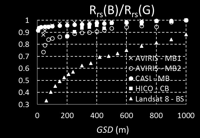
18 Platform & Instrument In-water; ac-s Shipboard; ac-s Airborne; lidar Airborne; AVIRIS Airborne; CASI Spaceborne; HICO Transect Long Island Sound Parameter LL Method GSD t (m) SP Method [a p (450)] LIS [c p (650)] LIS Savannah New York [a p (450)] SN, [c p (650)] SN None None San Diego Coast [a p (450)] SD, [c p (650)] SD None None Virginia Coast [K sys (532)] VC [b b (532)] VC Mid-Atlantic Bight [b b (532)] MAB [K sys (532)] MAB Georges Bank and [b b (532)] GBM Gulf of Maine [K sys (532)] GBM 200* 200* [R rs_b ] SFB, [R rs_b/g ] SFB San Francisco Bay [R rs_g ] SFB [R rs_r ] SFB Monterey Bay 1 Monterey Bay 2 Monterey Bay Chesapeake Bay [R rs_b ] A-MB1, [R rs_g ] A-MB1, [R rs_r ] A-MB [R rs_b/g ] A-MB [R rs_b ] A-MB [R rs_g ] A-MB2 None None [R rs_r ] A-MB2, [R rs_b/g ] A-MB [R rs_b ] C-MB [R rs_g ] C-MB None 150 [R rs_r ] C-MB [R rs_b/g ] C-MB None None [R rs_b ] CB, [R rs_g ] CB, [R rs_r ] CB None None [R rs_b/g ] CB Spaceborne; Landsat-8 Baltic Sea [R rs_b ] BS, [R rs_g ] BS, [R rs_r ] BS, [R rs_b/g ] BS None None
19 Results 19 (for coastal waters) Average GSD t (LL): 173 m Average GSD t (SP): 217 m ~ 200 m GSD t generally smaller for regions closer to the shore (dominated by scattering processes) Does not imply that 200 m is sufficient; it simply means that beyond 200 m there is a significant loss in the ability to capture spatial variability

20 20 Cédric Jamet and Hubert Loisel Spatial resolution of ~200 m for capturing most changes in coastal Rrs
21 Spectral Resolution 21 What spectral resolution is required to resolve spectral features in complex inland and coastal waters?


22 Ryan Vandermeulen, Antonio Mannino, and Aimee Neeley 22
23 Signal-to-Noise Ratio (SNR) 23 Trade-off amongst Spatial Resolution Spectral Resolution SNR

24 Trade-off 24


25 Trade-off 25 SNR 150
26 What does SNR 150 mean for retrievals? 26 A single case study Add noise to Rrs spectrum at SNR = 700 and 850 Estimate chl-a for both cases and compare to the estimate from noiseless Rrs spectrum to determine the uncertainty due to noise, U SNR Effects of SNR on atmospheric correction not considered here U SNR=700 = 0.17 ± 4.5% U SNR=850 = 0.15 ± 3.7%
. Pahlevan, N., Sarkar, S., Franz, B. A., He, J.")
27 Impact of spatial aggregation on R rs (blue) Pahlevan et al. (2017) 27 Spatial averaging can only qualitatively improve the product quality. Even after spatial averaging, the OLI-derived products are of higher quality (due to its better SNRs). Pahlevan, N., Sarkar, S., Franz, B. A., He, J. Sentinel-2 MultiSpectral Instrument (MSI) data processing for aquatic science applications: Demonstrations and preliminary validations. Submitted to Remote Sensing of Environment
 is above 600:1, an SNR(vis) better than 400:1 will not make a significant reduction in product")
28 Signal-to-Noise Ratio (SNR) 28 Atmospheric correction is a major contributor of uncertainties in retrievals Lin Qi, Zhongping Lee, Chuanmin Hu, and Menghua Wang once SNR(NIR) is above 600:1, an SNR(vis) better than 400:1 will not make a significant reduction in product uncertainties
29 TSS (gm -3 ) Temporal Resolution 29 TSS concentration in Sacramento-San Joaquin River from SPOT Take 5 Data Christiana Ade et al. (see poster)

 The presence of")
30 Synergistic Use of Satellite Data 30 Lake Kinneret (Israel) HICO Image 11 Mar Mar 2013 MODIS R645 Phycoerythrin 0.02 Phycocyanin Rrs (sr -1 ) Wavelength (nm) The presence of phycoerythrin and phycocyanin was confirmed by lab analysis of water samples
31 Acknowledgments 31 Help with data and analysis for the Spatial Resolution Study: Dr. Steven Ackleson (Naval Research Laboratory) Dr. Dave Miller (Naval Research Laboratory) Dr. Emmanuel Boss (University of Maine) Dr. Chris Hostetler (NASA Langley Research Center) Dr. Jonathan Hair (NASA Langley Research Center)


32 32 Contact:
Jeffrey H. Bowles, Wesley J. Moses, Gia M. Lamela, Richard Mied, Karen W. Patterson, and Ellen J. Wagner
 1 Jeffrey H. Bowles, Wesley J. Moses, Gia M. Lamela, Richard Mied, Karen W. Patterson, and Ellen J. Wagner and, Washington, D.C. from Center for Advanced Land Management Information Technologies (CALMIT),
Remote Sensing of Inland and Coastal Waters: Current Status, Challenges, Research Priorities, and End-User Engagement
 1 Breakout Workshop #4 Remote Sensing of Inland and Coastal Waters: Current Status, Challenges, Research Priorities, and End-User Engagement Co-Chairs: PLENARY REPORT Wes Moses, Carsten Brockmann, Andrew
Atmospheric Correction for Coastal and Inland Waters Current Capabilities and Challenges
 Atmospheric Correction for Coastal and Inland Waters Current Capabilities and Challenges Nima Pahlevan Research Scientist NASA Goddard Space Flight Center Science Systems and Applications Inc. Outline
On the use of water color missions for lakes in 2021
 Lakes and Climate: The Role of Remote Sensing June 01-02, 2017 On the use of water color missions for lakes in 2021 Cédric G. Fichot Department of Earth and Environment 1 Overview 1. Past and still-ongoing
NASA OBPG Satellite Ocean Color Update
 NASA OBPG Satellite Ocean Color Update Bryan Franz and the Ocean Biology Processing Group NASA Goddard Space Flight Center IOCS Meeting Ocean Color Research Team Meeting 18 May 2017, Lisbon, Portugal NASA
Remote Sensing Mapping of Turbidity in the Upper San Francisco Estuary. Francine Mejia, Geography 342
 Remote Sensing Mapping of Turbidity in the Upper San Francisco Estuary Francine Mejia, Geography 342 Introduction The sensitivity of reflectance to sediment, chlorophyll a, and colored DOM (CDOM) in the
Evaluation and improvements of MERIS, OLCI and SLSTR Rrs in contrasted turbid waters
 Evaluation and improvements of MERIS, OLCI and SLSTR Rrs in contrasted turbid waters Jamet, C., H., Loisel, M.A. Mograne, D., Dessailly, X., Mériaux and A., Cauvin Laboratoire d Océanologie et de Géosciences
remote sensing? What are the remote sensing principles behind these Definition
 Introduction to remote sensing: Content (1/2) Definition: photogrammetry and remote sensing (PRS) Radiation sources: solar radiation (passive optical RS) earth emission (passive microwave or thermal infrared
CHARACTERISTICS OF REMOTELY SENSED IMAGERY. Radiometric Resolution
 CHARACTERISTICS OF REMOTELY SENSED IMAGERY Radiometric Resolution There are a number of ways in which images can differ. One set of important differences relate to the various resolutions that images express.
The Development of Imaging Spectrometry of the Coastal Ocean
 SU_8/2/2006_Davis.1 The Development of Imaging Spectrometry of the Coastal Ocean Curtiss O. Davis College of Oceanic and Atmospheric Sciences, Oregon State University, Corvallis, OR 97331 cdavis@coas.oregonstate.edu
Improved monitoring of bio-optical processes in coastal and inland waters using high spatial resolution channels on SNPP-VIIRS sensor
 Improved monitoring of bio-optical processes in coastal and inland waters using high spatial resolution channels on SNPP-VIIRS sensor Ryan A. Vandermeulen* a, Robert Arnone a, Sherwin Ladner b, Paul Martinolich
Light penetration within a clear water body. E z = E 0 e -kz
 THE BLUE PLANET 1 2 Light penetration within a clear water body E z = E 0 e -kz 3 4 5 Pure Seawater Phytoplankton b w 10-2 m -1 b w 10-2 m -1 b w, Morel (1974) a w, Pope and Fry (1997) b chl,loisel and
Test, Evaluate, and Characterize a Remote-Sensing Algorithm for Optically-Shallow Waters
 DISTRIBUTION STATEMENT A: Approved for public release; distribution is unlimited. Test, Evaluate, and Characterize a Remote-Sensing Algorithm for Optically-Shallow Waters ZhongPing Lee Geosystems Research
ASSESSMENT OF SENTINEL-3/OLCI SUB-PIXEL VARIABILITY AND PLATFORM IMPACT USING LANDSAT-8/OLI
 ASSESSMENT OF SENTINEL-3/OLCI SUB-PIXEL VARIABILITY AND PLATFORM IMPACT USING LANDSAT-8/OLI Quinten Vanhellemont (1), Kevin Ruddick (1) (1) Royal Belgian Institute of Natural Sciences (RBINS), Operational
1. INTRODUCTION. GOCI : Geostationary Ocean Color Imager
 1. INTRODUCTION The Korea Ocean Research and Development Institute (KORDI) releases an announcement of opportunity (AO) to carry out scientific research for the utilization of GOCI data. GOCI is the world
ACOLITE FOR SENTINEL-2: AQUATIC APPLICATIONS OF MSI IMAGERY
 ACOLITE FOR SENTINEL-2: AQUATIC APPLICATIONS OF MSI IMAGERY Quinten Vanhellemont (1) and Kevin Ruddick (1) (1) Royal Belgian Institute for Natural Sciences, Operational Directorate Natural Environment,
Multiplatform Remote Sensing for Coral Reef Community Assessment
 Multiplatform Remote Sensing for Coral Reef Community Assessment Quinta Reunión Nacional de Percepción Remota y Sistemas de Información Geográfica en Puerto Rico September 27, 2007 Roy A. Armstrong, Ph.
Looking at 637 nm VIIRS band, S-NPP
 Looking at 637 nm VIIRS band, S-NPP bguenther@stellarsolutions.com (Sharpening I1) B. GUENTHER STELLAR SOLUTIONS, INC NOAA-JPSS 1 I am looking at houses and have a desire to know how much living area this
Exelis Visual Information Solutions
 Craig Cowan, Defence and Security Business Development craig.cowan@exelisinc.com www.exelisvis.eu Exelis Visual Information Solutions Hyperspectral Imagery Exploitation Sensors Symposium, Stockholm 10
Textbook, Chapter 15 Textbook, Chapter 10 (only 10.6)
") AGOG 484/584/ APLN 551 Fall 2018 Concept definition Applications Instruments and platforms Techniques to process hyperspectral data A problem of mixed pixels and spectral unmixing Reading Textbook, Chapter
AGOG 484/584/ APLN 551 Fall 2018 Concept definition Applications Instruments and platforms Techniques to process hyperspectral data A problem of mixed pixels and spectral unmixing Reading Textbook, Chapter
Hyperspectral Imaging of the Coastal Ocean
 Hyperspectral Imaging of the Coastal Ocean Curtiss O. Davis College of Oceanic and Atmospheric Sciences, 04 COAS Admin, Bldg., Corvallis, OR 9733 phone: (54) 737-5707 fax: (54) 737-2064 email: cdavis@coas.oregonstate.edu
A Study on Retrieval Algorithm of Black Water Aggregation in Taihu Lake Based on HJ-1 Satellite Images
 IOP Conference Series: Earth and Environmental Science OPEN ACCESS A Study on Retrieval Algorithm of Black Water Aggregation in Taihu Lake Based on HJ-1 Satellite Images To cite this article: Zou Lei et
Some Basic Concepts of Remote Sensing. Lecture 2 August 31, 2005
 Some Basic Concepts of Remote Sensing Lecture 2 August 31, 2005 What is remote sensing Remote Sensing: remote sensing is science of acquiring, processing, and interpreting images and related data that
All rights reserved. ENVI, IDL and Jagwire are trademarks of Exelis, Inc. All other marks are the property of their respective owners.
 Services Engine The HICO Online Processing System: A Web-Enabled Coastal Hyperspectral Imagery Processing System All rights reserved. ENVI, IDL and Jagwire are trademarks of Exelis, Inc. All other marks
Satellite Imagery and Remote Sensing. DeeDee Whitaker SW Guilford High EES & Chemistry
 Satellite Imagery and Remote Sensing DeeDee Whitaker SW Guilford High EES & Chemistry whitakd@gcsnc.com Outline What is remote sensing? How does remote sensing work? What role does the electromagnetic
JRC CAL/VAL Giuseppe Zibordi
 JRC CAL/VAL Giuseppe Zibordi in collaboration with JRC-IES Marine Team and GSFC-AERONET Team OCVC-Workshop, Ispra, October 20, 2010 1 Reduction of uncertainties in current remote sensing coastal products
Spectral Signatures. Vegetation. 40 Soil. Water WAVELENGTH (microns)
") Spectral Signatures % REFLECTANCE VISIBLE NEAR INFRARED Vegetation Soil Water.5. WAVELENGTH (microns). Spectral Reflectance of Urban Materials 5 Parking Lot 5 (5=5%) Reflectance 5 5 5 5 5 Wavelength (nm)
Spectral Signatures % REFLECTANCE VISIBLE NEAR INFRARED Vegetation Soil Water.5. WAVELENGTH (microns). Spectral Reflectance of Urban Materials 5 Parking Lot 5 (5=5%) Reflectance 5 5 5 5 5 Wavelength (nm)
MULTI-TEMPORAL SATELLITE IMAGES WITH BATHYMETRY CORRECTION FOR MAPPING AND ASSESSING SEAGRASS BED CHANGES IN DONGSHA ATOLL
 MULTI-TEMPORAL SATELLITE IMAGES WITH BATHYMETRY CORRECTION FOR MAPPING AND ASSESSING SEAGRASS BED CHANGES IN DONGSHA ATOLL Chih -Yuan Lin and Hsuan Ren Center for Space and Remote Sensing Research, National
Hyperspectral Imaging of River Systems
 DISTRIBUTION STATEMENT A. Approved for public release; distribution is unlimited. Hyperspectral Imaging of River Systems Curtiss O. Davis College of Oceanic and Atmospheric Sciences 104 COAS Admin, Bldg
HTEP - Water Quality Application
 HTEP - Water Quality Application Prepared by: Joël Hogeveen Delft University of Technology 2 March 2017 This document provides information about the Water Quality application of the Hydrology Thematic
Hyperspectral Sensor
 Hyperspectral Sensor Detlev Even 733 Bishop Street, Suite 2800 Honolulu, HI 96813 phone: (808) 441-3610 fax: (808) 441-3601 email: detlev@nova-sol.com Arleen Velasco 15150 Avenue of Science San Diego,
PILOTING A DECISION SUPPORT TOOL (DST) FOR MAPPING CYANOBACTERIAL HARMFUL ALGAL BLOOMS (CHABS) TO SUPPORT PUBLIC HEALTH AND RESOURCE MANAGEMENT.
 FOR MAPPING CYANOBACTERIAL HARMFUL ALGAL BLOOMS (CHABS) TO SUPPORT PUBLIC HEALTH AND RESOURCE MANAGEMENT.") PILOTING A DECISION SUPPORT TOOL (DST) FOR MAPPING CYANOBACTERIAL HARMFUL ALGAL BLOOMS (CHABS) TO SUPPORT PUBLIC HEALTH AND RESOURCE MANAGEMENT. Nathan Torbick, Applied Geosolutions Scott Stoodley, Director,
PILOTING A DECISION SUPPORT TOOL (DST) FOR MAPPING CYANOBACTERIAL HARMFUL ALGAL BLOOMS (CHABS) TO SUPPORT PUBLIC HEALTH AND RESOURCE MANAGEMENT. Nathan Torbick, Applied Geosolutions Scott Stoodley, Director,
IDENTIFICATION AND MAPPING OF HAWAIIAN CORAL REEFS USING HYPERSPECTRAL REMOTE SENSING
 IDENTIFICATION AND MAPPING OF HAWAIIAN CORAL REEFS USING HYPERSPECTRAL REMOTE SENSING Jessica Frances N. Ayau College of Education University of Hawai i at Mānoa Honolulu, HI 96822 ABSTRACT Coral reefs
ISIS TC Meeting. International Spaceborne Imaging Spectroscopy (ISIS) GRSS Technical Committee Meeting, 16/07/2014, IGARSS 2014
 GRSS Technical Committee Meeting, 16/07/2014, IGARSS 2014") ISIS TC Meeting International Spaceborne Imaging Spectroscopy (ISIS) GRSS Technical Committee Meeting, 16/07/2014, IGARSS 2014 Andreas Müller (DLR) Cindy Ong (CSIRO) Uta Heiden (DLR) Agenda Hyperspectral
ISIS TC Meeting International Spaceborne Imaging Spectroscopy (ISIS) GRSS Technical Committee Meeting, 16/07/2014, IGARSS 2014 Andreas Müller (DLR) Cindy Ong (CSIRO) Uta Heiden (DLR) Agenda Hyperspectral
Evaluation of Sentinel-2 bands over the spectrum
 Evaluation of Sentinel-2 bands over the spectrum S.E. Hosseini Aria, M. Menenti, Geoscience and Remote sensing Department Delft University of Technology, Netherlands 1 outline ointroduction - Concept odata
Introduction to Remote Sensing
 Introduction to Remote Sensing Outline Remote Sensing Defined Resolution Electromagnetic Energy (EMR) Types Interpretation Applications Remote Sensing Defined Remote Sensing is: The art and science of
EnMAP Environmental Mapping and Analysis Program
 EnMAP Environmental Mapping and Analysis Program www.enmap.org Mathias Schneider Mission Objectives Regular provision of high-quality calibrated hyperspectral data Precise measurement of ecosystem parameters
Shallow Water Remote Sensing
 Shallow Water Remote Sensing John Hedley, IOCCG Summer Class 2018 Overview - different methods and applications Physics-based model inversion methods High spatial resolution imagery and Sentinel-2 Bottom
NORMALIZING ASTER DATA USING MODIS PRODUCTS FOR LAND COVER CLASSIFICATION
 NORMALIZING ASTER DATA USING MODIS PRODUCTS FOR LAND COVER CLASSIFICATION F. Gao a, b, *, J. G. Masek a a Biospheric Sciences Branch, NASA Goddard Space Flight Center, Greenbelt, MD 20771, USA b Earth
Introduction to Remote Sensing of the Environment. Dr. Anne Nolin Department of Geosciences
 Introduction to Remote Sensing of the Environment Dr. Anne Nolin Department of Geosciences Overview of today s lecture Course overview Definitions How measurements are made Analog vs. digital The remote
University of Texas at San Antonio EES 5053 Term Project CORRELATION BETWEEN NDVI AND SURFACE TEMPERATURES USING LANDSAT ETM + IMAGERY NEWFEL MAZARI
 University of Texas at San Antonio EES 5053 Term Project CORRELATION BETWEEN NDVI AND SURFACE TEMPERATURES USING LANDSAT ETM + IMAGERY NEWFEL MAZARI Introduction and Objectives The present study is a correlation
Outline for today. Geography 411/611 Remote sensing: Principles and Applications. Remote sensing: RS for biogeochemical cycles
 Geography 411/611 Remote sensing: Principles and Applications Thomas Albright, Associate Professor Laboratory for Conservation Biogeography, Department of Geography & Program in Ecology, Evolution, & Conservation
GOCI Status and Cooperation with CoastColour Project
 GOCI Status and Cooperation with CoastColour Project Joo-Hyung RYU Contribution from : KOSC colleaques Nov. 17, 2010 World 1 st GOCI/COMS Launch Campaign Launch Date : June 27 2010 Launch Vehicle : Ariane-V
Introduction to Remote Sensing
 Introduction to Remote Sensing Spatial, spectral, temporal resolutions Image display alternatives Vegetation Indices Image classifications Image change detections Accuracy assessment Satellites & Air-Photos
Application of Remote Sensing in the Monitoring of Marine pollution. By Atif Shahzad Institute of Environmental Studies University of Karachi
 Application of Remote Sensing in the Monitoring of Marine pollution By Atif Shahzad Institute of Environmental Studies University of Karachi Remote Sensing "Remote sensing is the science (and to some extent,
The studies began when the Tiros satellites (1960) provided man s first synoptic view of the Earth s weather systems.
 provided man s first synoptic view of the Earth s weather systems.") Remote sensing of the Earth from orbital altitudes was recognized in the mid-1960 s as a potential technique for obtaining information important for the effective use and conservation of natural resources.
Remote sensing of the Earth from orbital altitudes was recognized in the mid-1960 s as a potential technique for obtaining information important for the effective use and conservation of natural resources.
Multispectral Scanners for Wildland Fire Assessment NASA Ames Research Center Earth Science Division. Bruce Coffland U.C.
 Multispectral Scanners for Wildland Fire Assessment NASA Earth Science Division Bruce Coffland U.C. Santa Cruz Slide Fire Burn Area (MASTER/B200) R 2.2um G 0.87um B 0.65um Airborne Science & Technology
746A27 Remote Sensing and GIS. Multi spectral, thermal and hyper spectral sensing and usage
 746A27 Remote Sensing and GIS Lecture 3 Multi spectral, thermal and hyper spectral sensing and usage Chandan Roy Guest Lecturer Department of Computer and Information Science Linköping University Multi
Part 1: New spectral stuff going on at NIST. Part 2: TSI Traceability of TRF to NIST
 Part 1: New spectral stuff going on at NIST SIRCUS-type stuff (tunable lasers) now migrating to LASP Absolute Spectrally-Tunable Detector-Based Source Spectrally-programmable source calibrated via NIST
An Introduction to Geomatics. Prepared by: Dr. Maher A. El-Hallaq خاص بطلبة مساق مقدمة في علم. Associate Professor of Surveying IUG
 An Introduction to Geomatics خاص بطلبة مساق مقدمة في علم الجيوماتكس Prepared by: Dr. Maher A. El-Hallaq Associate Professor of Surveying IUG 1 Airborne Imagery Dr. Maher A. El-Hallaq Associate Professor
Introduction to Remote Sensing
 Introduction to Remote Sensing Dr. Mathias (Mat) Disney UCL Geography Office: 301, 3rd Floor, Chandler House Tel: 7670 4290 Email: mdisney@ucl.geog.ac.uk www.geog.ucl.ac.uk/~mdisney 1 Course outline Format
Using Ground Targets for Sensor On orbit Calibration Support
 EOS Using Ground Targets for Sensor On orbit Calibration Support X. Xiong, A. Angal, A. Wu, and T. Choi MODIS Characterization Support Team (MCST), NASA/GSFC G. Chander SGT/USGS EROS CEOS Libya 4 Workshop,
RADAR (RAdio Detection And Ranging)
") RADAR (RAdio Detection And Ranging) CLASSIFICATION OF NONPHOTOGRAPHIC REMOTE SENSORS PASSIVE ACTIVE DIGITAL CAMERA THERMAL (e.g. TIMS) VIDEO CAMERA MULTI- SPECTRAL SCANNERS VISIBLE & NIR MICROWAVE Real
RADAR (RAdio Detection And Ranging) CLASSIFICATION OF NONPHOTOGRAPHIC REMOTE SENSORS PASSIVE ACTIVE DIGITAL CAMERA THERMAL (e.g. TIMS) VIDEO CAMERA MULTI- SPECTRAL SCANNERS VISIBLE & NIR MICROWAVE Real
Relationship Between Landsat 8 Spectral Reflectance and Chlorophyll-a in Grand Lake, Oklahoma
 Relationship Between Landsat 8 Spectral Reflectance and Chlorophyll-a in Grand Lake, Oklahoma Presented by: Abu Mansaray Research Team Dr. Andrew Dzialowski (PI), Oklahoma State University Dr. Scott Stoodley
Increased potential to monitor water quality in the near-shore environment with Landsat s next-generation satellite
 Increased potential to monitor water quality in the near-shore environment with Landsat s next-generation satellite Aaron D. Gerace John R. Schott Robert Nevins Increased potential to monitor water quality
Remote Sensing 1 Principles of visible and radar remote sensing & sensors
 Remote Sensing 1 Principles of visible and radar remote sensing & sensors Nick Barrand School of Geography, Earth & Environmental Sciences University of Birmingham, UK Field glaciologist collecting data
Pléiades imagery for coastal and inland water applications
 Pléiades imagery for coastal and inland water applications Pléiades 2014-09-08 Quinten Vanhellemont & PONDER project 2017-10-20 dredging ship PONDER SR/00/325 «Ocean colour remote sensing» Remote sensing
Monitoring water pollution in the river Ganga with innovations in airborne remote sensing and drone technology
 Monitoring water pollution in the river Ganga with innovations in airborne remote sensing and drone technology RAJIV SINHA, DIPRO SARKAR DEPARTMENT OF EARTH SCIENCES, INDIAN INSTITUTE OF TECHNOLOGY KANPUR,
REMOTE SENSING. Topic 10 Fundamentals of Digital Multispectral Remote Sensing MULTISPECTRAL SCANNERS MULTISPECTRAL SCANNERS
 REMOTE SENSING Topic 10 Fundamentals of Digital Multispectral Remote Sensing Chapter 5: Lillesand and Keifer Chapter 6: Avery and Berlin MULTISPECTRAL SCANNERS Record EMR in a number of discrete portions
Center for Advanced Land Management Information Technologies (CALMIT), School of Natural Resources, University of Nebraska-Lincoln
, School of Natural Resources, University of Nebraska-Lincoln") Geoffrey M. Henebry, Andrés Viña, and Anatoly A. Gitelson Center for Advanced Land Management Information Technologies (CALMIT), School of Natural Resources, University of Nebraska-Lincoln Introduction
Geoffrey M. Henebry, Andrés Viña, and Anatoly A. Gitelson Center for Advanced Land Management Information Technologies (CALMIT), School of Natural Resources, University of Nebraska-Lincoln Introduction
Introduction of Satellite Remote Sensing
 Introduction of Satellite Remote Sensing Spatial Resolution (Pixel size) Spectral Resolution (Bands) Resolutions of Remote Sensing 1. Spatial (what area and how detailed) 2. Spectral (what colors bands)
Light penetration within a clear water body. E z = E 0 e -kz
 THE BLUE PLANET 1 2 Light penetration within a clear water body E z = E 0 e -kz 3 4 5 6 Pure Seawater Phytoplankton b w 10-2 m -1 b w 10-2 m -1 b w, Morel (1974) a w, Pope and Fry (1997) b chl,loisel and
MERIS instrument. Muriel Simon, Serco c/o ESA
 MERIS instrument Muriel Simon, Serco c/o ESA Workshop on Sustainable Development in Mountain Areas of Andean Countries Mendoza, Argentina, 26-30 November 2007 ENVISAT MISSION 2 Mission Chlorophyll case
Introduction to Remote Sensing Fundamentals of Satellite Remote Sensing. Mads Olander Rasmussen
 Introduction to Remote Sensing Fundamentals of Satellite Remote Sensing Mads Olander Rasmussen (mora@dhi-gras.com) 01. Introduction to Remote Sensing DHI What is remote sensing? the art, science, and technology
CHARACTERISTICS OF REMOTELY SENSED IMAGERY. Spatial Resolution
 CHARACTERISTICS OF REMOTELY SENSED IMAGERY Spatial Resolution There are a number of ways in which images can differ. One set of important differences relate to the various resolutions that images express.
FLIGHT SUMMARY REPORT
 FLIGHT SUMMARY REPORT Flight Number: 97-011 Calendar/Julian Date: 23 October 1996 297 Sensor Package: Area(s) Covered: Wild-Heerbrugg RC-10 Airborne Visible and Infrared Imaging Spectrometer (AVIRIS) Southern
MULTISPECTRAL IMAGE PROCESSING I
 TM1 TM2 337 TM3 TM4 TM5 TM6 Dr. Robert A. Schowengerdt TM7 Landsat Thematic Mapper (TM) multispectral images of desert and agriculture near Yuma, Arizona MULTISPECTRAL IMAGE PROCESSING I SENSORS Multispectral
A broad survey of remote sensing applications for many environmental disciplines
 1 2 3 4 A broad survey of remote sensing applications for many environmental disciplines 5 6 7 8 9 10 1. First definition is very general and applies to many types of remote sensing. You use your eyes
Evaluation of FLAASH atmospheric correction. Note. Note no SAMBA/10/12. Authors. Øystein Rudjord and Øivind Due Trier
 Evaluation of FLAASH atmospheric correction Note Note no Authors SAMBA/10/12 Øystein Rudjord and Øivind Due Trier Date 16 February 2012 Norsk Regnesentral Norsk Regnesentral (Norwegian Computing Center,
Introduction to Remote Sensing
 Introduction to Remote Sensing Daniel McInerney Urban Institute Ireland, University College Dublin, Richview Campus, Clonskeagh Drive, Dublin 14. 16th June 2009 Presentation Outline 1 2 Spaceborne Sensors
Fundamentals of Remote Sensing
 Climate Variability, Hydrology, and Flooding Fundamentals of Remote Sensing May 19-22, 2015 GEO-Latin American & Caribbean Water Cycle Capacity Building Workshop Cartagena, Colombia 1 Objective To provide
Sentinel-2 Products and Algorithms
 Sentinel-2 Products and Algorithms Ferran Gascon (Sentinel-2 Data Quality Manager) Workshop Preparations for Sentinel 2 in Europe, Oslo 26 November 2014 Sentinel-2 Mission Mission Overview Products and
Automatic processing to restore data of MODIS band 6
 Automatic processing to restore data of MODIS band 6 --Final Project for ECE 533 Abstract An automatic processing to restore data of MODIS band 6 is introduced. For each granule of MODIS data, 6% of the
Remote Sensing Platforms
 Types of Platforms Lighter-than-air Remote Sensing Platforms Free floating balloons Restricted by atmospheric conditions Used to acquire meteorological/atmospheric data Blimps/dirigibles Major role - news
Advanced satellite image fusion techniques for estimating high resolution Land Surface Temperature time series
 COMECAP 2014 e-book of proceedings vol. 2 Page 267 Advanced satellite image fusion techniques for estimating high resolution Land Surface Temperature time series Mitraka Z., Chrysoulakis N. Land Surface
Ocean Color Measurements from Landsat-8 OLI using SeaDAS
 https://ntrs.nasa.gov/search.jsp?r=20150023307 2019-02-25T00:59:34+00:00Z Ocean Color Measurements from Landsat-8 OLI using SeaDAS Bryan A. Franz 1, Sean W. Bailey 1,2, Norman Kuring 1, and P. Jeremy Werdell
Use of Drifting Buoy SST in Remote Sensing. Chris Merchant University of Edinburgh Gary Corlett University of Leicester
 Use of Drifting Buoy SST in Remote Sensing Chris Merchant University of Edinburgh Gary Corlett University of Leicester Three decades of AVHRR SST Empirical regression to buoy SSTs to define retrieval Agreement
typical spectral signatures of photosynthetically active and non-photosynthetically active vegetation (Beeri et al., 2007)
") typical spectral signatures of photosynthetically active and non-photosynthetically active vegetation (Beeri et al., 2007) Xie, Y. et al. J Plant Ecol 2008 1:9-23; doi:10.1093/jpe/rtm005 Copyright restrictions
typical spectral signatures of photosynthetically active and non-photosynthetically active vegetation (Beeri et al., 2007) Xie, Y. et al. J Plant Ecol 2008 1:9-23; doi:10.1093/jpe/rtm005 Copyright restrictions
Remote sensing monitoring of coastline change in Pearl River estuary
 Remote sensing monitoring of coastline change in Pearl River estuary Xiaoge Zhu Remote Sensing Geology Department Research Institute of Petroleum Exploration and Development (RIPED) PetroChina Company
Remote Sensing. Division C. Written Exam
 Remote Sensing Division C Written Exam Team Name: Team #: Team Members: _ Score: /132 A. Matching (10 points) 1. Nadir 2. Albedo 3. Diffraction 4. Refraction 5. Spatial Resolution 6. Temporal Resolution
THE Hyperspectral Imager for the Coastal Ocean (HICO)
") 824 IEEE TRANSACTIONS ON GEOSCIENCE AND REMOTE SENSING, VOL. 50, NO. 3, MARCH 2012 A Technique For Removing Second-Order Light Effects From Hyperspectral Imaging Data Rong-Rong Li, Robert Lucke, Daniel
824 IEEE TRANSACTIONS ON GEOSCIENCE AND REMOTE SENSING, VOL. 50, NO. 3, MARCH 2012 A Technique For Removing Second-Order Light Effects From Hyperspectral Imaging Data Rong-Rong Li, Robert Lucke, Daniel
Recent developments in Deep Blue satellite aerosol data products from NASA GSFC
 Recent developments in Deep Blue satellite aerosol data products from NASA GSFC Andrew M. Sayer, N. Christina Hsu (PI), Corey Bettenhausen, Myeong-Jae Jeong Climate & Radiation Laboratory, NASA Goddard
Interrogating MODIS & AIRS data using HYDRA
 Interrogating MODIS & AIRS data using HYDRA Paul Menzel NOAA Satellite and Information Services What is HYDRA? What can it do? Some examples How to get it? HYperspectral viewer for Development of Research
Earth-observing satellite intercomparison using the Radiometric Calibration Test Site at Railroad Valley
 Earth-observing satellite intercomparison using the Radiometric Calibration Test Site at Railroad Valley Jeffrey Czapla-Myers Joel McCorkel Nikolaus Anderson Stuart Biggar Jeffrey Czapla-Myers, Joel McCorkel,
Status of Aqua MODIS Reflective Solar Bands Calibration and Performance
 EOS Status of Aqua MODIS Reflective Solar Bands Calibration and Performance Jack Xiong NASA GSFC, Greenbelt, MD 20771, USA A. Angal, H. Chen, X. Geng, D. Link, Y. Li, and A. Wu SSAI, 10210 Greenbelt Road,
An Introduction to Remote Sensing & GIS. Introduction
 An Introduction to Remote Sensing & GIS Introduction Remote sensing is the measurement of object properties on Earth s surface using data acquired from aircraft and satellites. It attempts to measure something
Basic Hyperspectral Analysis Tutorial
 Basic Hyperspectral Analysis Tutorial This tutorial introduces you to visualization and interactive analysis tools for working with hyperspectral data. In this tutorial, you will: Analyze spectral profiles
Coastal Waters Imaging and Proposed Next Steps
 SU_2/20/2006_Davis.1 Coastal Waters Imaging and Proposed Next Steps Curtiss O. Davis College of Oceanic and Atmospheric Sciences Oregon State University, Corvallis, Oregon 97331 541-737-4432 cdavis@coas.oregonstate.edu
Lecture 6: Multispectral Earth Resource Satellites. The University at Albany Fall 2018 Geography and Planning
 Lecture 6: Multispectral Earth Resource Satellites The University at Albany Fall 2018 Geography and Planning Outline SPOT program and other moderate resolution systems High resolution satellite systems
Radiometric Validation of Sentinel-3
 Radiometric Validation of Sentinel-3 by Kevin Ruddick, Dimitry Van Der Zande and Quinten Vanhellemont (RBINS, ODNature, REMSEM) Sentinel-2 Radiometric Validation of Sentinel-3 by Kevin Ruddick, Dimitry
The Moderate Resolution Imaging Spectroradiometer (MODIS): Potential Applications for Climate Change and Modeling Studies
: Potential Applications for Climate Change and Modeling Studies") The Moderate Resolution Imaging Spectroradiometer (MODIS): Potential Applications for Climate Change and Modeling Studies Menas Kafatos, CEOSR, George Mason University Jim McManus, CEOSR, GMU and GES DISC
The Moderate Resolution Imaging Spectroradiometer (MODIS): Potential Applications for Climate Change and Modeling Studies Menas Kafatos, CEOSR, George Mason University Jim McManus, CEOSR, GMU and GES DISC
Present and future of marine production in Boka Kotorska
 Present and future of marine production in Boka Kotorska First results from satellite remote sensing for the breeding areas of filter feeders in the Bay of Kotor INTRODUCTION Environmental monitoring is
Status of MODIS, VIIRS, and OLI Sensors
 Status of MODIS, VIIRS, and OLI Sensors Xiaoxiong (Jack) Xiong, Jim Butler, and Brian Markham Code 618.0 NASA/GSFC, Greenbelt, MD 20771, USA Acknowledgements: NASA MODIS Characterization Support Team (MCST)
Multilook scene classification with spectral imagery
 Multilook scene classification with spectral imagery Richard C. Olsen a*, Brandt Tso b a Physics Department, Naval Postgraduate School, Monterey, CA, 93943, USA b Department of Resource Management, National
NRL SSC HICO Article for Oceans 09 Conference
 NRL SSC HICO Article for Oceans 09 Conference Title: The Hyperspectral Imager for the Coastal Ocean (HICO): Sensor and Data Processing Overview Abstract M.D. Lewis, R.W. Gould, Jr., R.A. Arnone, P.E. Lyon,
Spatial, Temporal, and Spectral Resolution Considerations for Imaging Coastal Waters
 SU 8-27-2007_Davis.1 Spatial, Temporal, and Spectral Resolution Considerations for Imaging Coastal Waters Curtiss O. Davis, Maria Kavanaugh, Ricardo Letelier, College of Oceanic and Atmospheric Sciences,
6th Beirut Water Week 27th February - 1st March 2017
 Assessment of chlorophyll-a concentration using Landsat Operational Land Imager in Lake Qaraoun, Lebanon Ali Fadel 6th Beirut Water Week 27th February - 1st March 2017 Introduction & problematic Worldwide
Remote Sensing Phenology. Bradley Reed Principal Scientist USGS National Center for Earth Resources Observation and Science Sioux Falls, SD
 Remote Sensing Phenology Bradley Reed Principal Scientist USGS National Center for Earth Resources Observation and Science Sioux Falls, SD Remote Sensing Phenology Potential to provide wall-to-wall phenology
Hyperspectral Imager for Coastal Ocean (HICO)
") Hyperspectral Imager for Coastal Ocean (HICO) Detlev Even 733 Bishop Street, Suite 2800 phone: (808) 441-3610 fax: (808) 441-3601 email: detlev@nova-sol.com Arleen Velasco 15150 Avenue of Science phone:
Hyperspectral Imager for Coastal Ocean (HICO) Detlev Even 733 Bishop Street, Suite 2800 phone: (808) 441-3610 fax: (808) 441-3601 email: detlev@nova-sol.com Arleen Velasco 15150 Avenue of Science phone:
NON-PHOTOGRAPHIC SYSTEMS: Multispectral Scanners Medium and coarse resolution sensor comparisons: Landsat, SPOT, AVHRR and MODIS
 NON-PHOTOGRAPHIC SYSTEMS: Multispectral Scanners Medium and coarse resolution sensor comparisons: Landsat, SPOT, AVHRR and MODIS CLASSIFICATION OF NONPHOTOGRAPHIC REMOTE SENSORS PASSIVE ACTIVE DIGITAL