GOCI Status and Cooperation with CoastColour Project
|
|
|
- Tracy Cross
- 5 years ago
- Views:
Transcription


1 GOCI Status and Cooperation with CoastColour Project Joo-Hyung RYU Contribution from : KOSC colleaques Nov. 17, 2010


2 World 1 st GOCI/COMS Launch Campaign Launch Date : June Launch Vehicle : Ariane-V (ESA) Location : Kourou Space Center, French Guiana
3 Previous GOCI special session & presentation Sep Ocean Optics meeting at Anchorage, USA Oct SPIE Asia Pacific Remote Sensing at Songdo, Korea Oct IVOS and OCR-VC meeting at Ispra, Italy Oct PORSEC at Taiwan, Taiwan Oct ISRS at Jeju, Korea Nov IOCCG Level 1 meeting at London, UK Nov CoastColour meeting at Frascati, Italy
4 A brief overview of GOCI GOCI : Geostationary Ocean Color Imager COMS : Communication Ocean and Meteorological Satellite It shall be operated in a staring-frame capture mode onboard its COMS. The mission concept includes eight visible-to-near-infrared bands, 500 m spatial resolution, and a coverage region of 2,500*2,500 km centered at Korea. The instrument is expected to provide SeaWiFS quality observations for a single study area with imager frequency of 1 hour from 9 am to 4 pm (8 times a day). GOCI Application : LEO mission + Operational mission harmful algae bloom (HAB), health of marine ecosystem, movement of suspended sediment and current, and to produce marine fisheries information for fishing communities + ocean forecasting (with modeling)
5 GEO vs. LEO GEO/GOCI LEO/SeaWiFS Altitude 35,857 km 705 km about 50 timesfar Sensor type Staring-frame capture 1-axis scanning Spatial resolution 500 m 1000 m 4 times better Spectral range Temporal resolution Sun-Satellite position nm nm Almost same 1 hour 1 day 8 times better variable stable BRDF Coverage local global limitation Bio-optical algorithm local global New local algorithm GEO is about 50 times farther from the Earth than LEO GEO spatial resolution is 4 times better than that of LEO GEO temporal resolution is 8 times better To be considered and prepared sensor type, geometry & local coverage for overcoming GEO characteristics

6 03:00(GMT) Oct. 26, 2010 GOCI

7 03:00(GMT) Nov. 16, 2010 GOCI
 East Asia : South and North Korea, China, Japan,")

8 GOCI coverage GOCI coverage / Earth surface = 6,250,000 / 520,000,000 km 2 = 1.2 % (Considering the geographical size, coverage area is very small) East Asia : South and North Korea, China, Japan, Russia, Taiwan Population : large (a heavily populated district) Economy, Commerce : big (container traffic) Defense, Military : important Environments : variable, changeable Climate change : serious China (? Billion) Russia Korea (70 million) Japan (100 million) Taiwan CoastColour project site 11

9 Issue 1 : Sensor type Slot 1 Slot 4 9:15 Slot 8 Slot 5 Slot 9 Slot 12 Slot 16 9:45 Slot 13 GOCI uses the staring-frame capture method It takes 30 min to acquire one set of whole coverage Time interval is induced between upper and lower lines The zigzag type of capture line brings about non-homogenous time interval

10 GOCI slots images Between Slot Radiometric discrepancy <4% Now we have analyzed reason and are coding correction algorithm

11 120 o E 125 o E 130 o E 135 o E 140 o E 50 o N Issue 2 RUSSIA : Geometry variation and Local coverage 45 o N 40 o N 35 o N KOREA JAPAN 30 o N 25 o N Total points: 1348 points IOP and AOP In situ measurement were performed during a lot of cruises in the Korean terrestorial seas and neighboring waters through the years onboard the KORDI research vessel and fisher boats.
, The coastal area of Korea & China and the ECS(seasonal variation) is a typical Case-2 waters East/Japan Sea, central YS & Pacific come under the Case-1")
12 Definition of Case-1 and 2 waters using in situ <chl> and <SS> data of the Korean Sea GOCI coverage : Case-II water In the GOCI swath (==CoastColour site 11), The coastal area of Korea & China and the ECS(seasonal variation) is a typical Case-2 waters East/Japan Sea, central YS & Pacific come under the Case-1 water
13 GDPS : GOCI Data Processing System Accessory Data file Analyzed data file Low level Data file Sub-routine Option LEVEL-0 Sector Image Calibration Coefficients Lookup Table Radiometric Calibration Bi- Directional Correction LEVEL-1A Digital values LEVEL-1B Total Radiance Water leaving Radiance LwN (B1-B8) Geometrical Correction & Mosaic Atmospheric Correction Reference Target SP Data New & old model ASCII-Data Generation Image Display Land Mask Turbid water Mask Cloud Mask K & Inherent Optical algorithm CASE-I&II & Fluor. Algorithm 1-Band Algorithm Absorption Coefficient Red-tide Index Fishing Ground Index Empirical Algorithm Image pattern Comparison 3-Bands Algorithm Optical Properties Water Chlorophyll TSS CDOM Red-Tide Fishing Ground Information Under water Visibility Water Current Vector Atm. & Earth Environment K-coefficient Absorption coeff. Backscattering Coeff New model Water Quality Level 1-5 Primary Productivity NOAA Image Yellow Dust Forest Fire Inland flood Vegetation Index Heavy snowfall


14 GDPS GUI

 R: 645 G:")
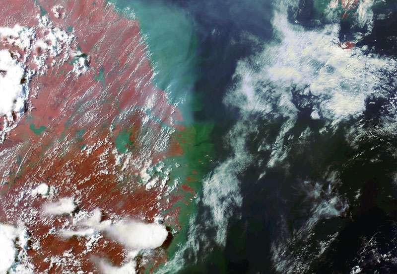
15 GOCI Image quality Image Comparison between GOCI and MODIS Aqua Yangtze River, China (GOCI, ) R: 660 G: 555 B:490 Yangtze River, China (MODIS Aqua, ) R: 645 G: 555 B:469


16


17

18 GOCI July 13, 2010 Japan

19

20 To get more clear data


21 Animation

22

23
24 Cal/Val activity in situ measurements Research vessel, Ferrybox(with KORDI), Glider(with KORDI) Buoy, Ocean research station : To use Korea Operational Oceanography Network(with KORDI) To cooperate neighboring countries (with Japan, China, Taiwan) To join International Group (with IOCCG, OCR-VS, Aeronet-OC) Inter-satellite Cal. Existing OC : MODIS, MERIS HICO (with D. Curtiss) New system Kite, aerostat, airborne (with KARI) Argo-type buoy Uniform land Cal/Val site Desert, Ice, Playa
 Korea")

")

")

25 Yellow Sea Buoy (2007) Korea Operational Oceanography Network Gageocho Station (2009) Dokdo Buoy (2009) Ieodo Station (2003) East(Japan) Sea Station (2012) Two buoys and two ocean stations have already been constructed by KOON project
 (R(680), G(555), B(412)) MERIS(2010 09 24")
) *GOCI image is geo-corrected by MERIS")
26 Comparison of GOCI and MERIS GOCI( : 16:43) (R(680), G(555), B(412)) MERIS( : 43:51) (R(681.55), G(560), B(412.5)) *GOCI image is geo-corrected by MERIS Geometric information

27 Comparison of GOCI and MERIS (Scatter Plot) GOCI:412nm, MERIS:412.5nm GOCI:,443nm, MERIS:442.5nm GOCI:490nm, MERIS:490nm GOCI:680nm, MERIS:681.5nm GOCI:865nm, MERIS:865nm
28 Cross Calibration with LEO Ocean Color Sensors Comparison of Spectral Channels SeaWiFS MODIS GOCI HICO MERIS Application 411nm 412 nm Hyperspectral nm CDOM 443 nm 442 nm 443 nm nm nm chlorophyll 487 nm 490 nm at 5.2 nm 490 nm Chl and other pigments 520 nm 530 nm Can match 510 nm turbidity 550 nm 547 nm 555 nm Any GOCI 560 nm Chl, suspended sediments channel 620 nm Suspended sediments 670 nm 665 nm 660 nm 665 nm Chl absorption 677 nm 680 nm nm Chl fluorescence 705 nm Blooms, Red edge nm 745 nm nm O 2 abs. ref., ocean aerosols Beyond 760 nm O 2 abs. Planned 775 nm Aerosols, vegetation Lifetime. 866 nm 865 nm 865 nm Aerosols over the ocean Little data 890 nm Water vapor reference In nm Water vapor absorption By D. Curtiss
29 Conclusion and Remarks Fully successful launch campaign of GOCI/COMS All functional tests for GOCI was successful. GOCI IOT is on-going. After GOCI IOT, KOSC will distribute GOCI data and GDPS SW. What can GOCI do for CoastColour? : GOCI data, local algorithm, and Cal/Val activity I hope to extend CoastColour(Case-II water) project for GOCI.

30 Planed GOCI Data Distribution at KOSC Developed GOCI Public Website at KOSC using published and approved for distribution data, publications and presentations. KOSC GOCI Web site would be portal for data requests and distribution Data requests require proposal and data agreement signed by the requestor and their institution and approved by MLTM. Thank you
The mission concept includes eight visible-to-near-infrared bands,, and a centered at Korea.
 eostationary cean olor mager : ommunication cean and eteorological atellite It shall be operated in a mode onboard its COMS. The mission concept includes eight visible-to-near-infrared bands,, and a centered
1. INTRODUCTION. GOCI : Geostationary Ocean Color Imager
 1. INTRODUCTION The Korea Ocean Research and Development Institute (KORDI) releases an announcement of opportunity (AO) to carry out scientific research for the utilization of GOCI data. GOCI is the world
On the use of water color missions for lakes in 2021
 Lakes and Climate: The Role of Remote Sensing June 01-02, 2017 On the use of water color missions for lakes in 2021 Cédric G. Fichot Department of Earth and Environment 1 Overview 1. Past and still-ongoing
Futrajaya, Malaysia JULY 12, Jeong Heon SONG. Korea Aerospace Research Institution
 J P T M 2 0 1 1 Futrajaya, Malaysia JULY 12, 2011 Jeong Heon SONG Korea Aerospace Research Institution Outline Contribution of KARI Sentinel Asia / Data Provider Node International Charter KARI Space Activities
Updates on GOCI & GOCI-II projects
 Updates on GOCI & GOCI-II projects Young-Je Park, Wonkook Kim* Contributed by KOSC staff Korea Ocean Satellite Center (KOSC) Korea Institute of Ocean Science and Technology (KIOST) AWOC2015 and 12 th JKWOC
Light penetration within a clear water body. E z = E 0 e -kz
 THE BLUE PLANET 1 2 Light penetration within a clear water body E z = E 0 e -kz 3 4 5 Pure Seawater Phytoplankton b w 10-2 m -1 b w 10-2 m -1 b w, Morel (1974) a w, Pope and Fry (1997) b chl,loisel and
Light penetration within a clear water body. E z = E 0 e -kz
 THE BLUE PLANET 1 2 Light penetration within a clear water body E z = E 0 e -kz 3 4 5 6 Pure Seawater Phytoplankton b w 10-2 m -1 b w 10-2 m -1 b w, Morel (1974) a w, Pope and Fry (1997) b chl,loisel and
MERIS data access over diagnostic sites for calibration and validation purposes
 MERIS data access over diagnostic sites for calibration and validation purposes Philippe Goryl ESA / ESRIN Philippe.Goryl@esa.int Carsten Brockman Brockman Consult Workshop on Inter-Comparison of Large
Theme: ocean colour observations from the geostationary orbit
 A new IOCCG working group Theme: ocean colour observations from the geostationary orbit Today (Nov 1 st, 2008):1 st Working group meeting, with the following goals: - Members of the WG meet and know better
MERIS instrument. Muriel Simon, Serco c/o ESA
 MERIS instrument Muriel Simon, Serco c/o ESA Workshop on Sustainable Development in Mountain Areas of Andean Countries Mendoza, Argentina, 26-30 November 2007 ENVISAT MISSION 2 Mission Chlorophyll case
Remote Sensing for Resource Management
 Remote Sensing for Resource Management Ebenezer Nyadjro US Naval Research Lab/UNO RMU Summer Program (July 31-AUG 4, 2017) Motivation Polluted Pra River Motivation. 3 Motivation Polluted Pra River Motivation.
NASA OBPG Satellite Ocean Color Update
 NASA OBPG Satellite Ocean Color Update Bryan Franz and the Ocean Biology Processing Group NASA Goddard Space Flight Center IOCS Meeting Ocean Color Research Team Meeting 18 May 2017, Lisbon, Portugal NASA
Sustained Ocean Color Research and Operations
 Sustained Ocean Color Research and Operations What are the minimum requirements to continue the SeaWiFS/MODIS time-series? Based on a National Research Council report by the Ocean Studies Board May 2011
DEVELOPING AN OCEAN COLOUR SERVICE SUPPORTING GLOBAL CARBON-CYCLE RESEARCH AND OPERATIONAL OCEANOGRAPHY
 DEVELOPING AN OCEAN COLOUR SERVICE SUPPORTING GLOBAL CARBON-CYCLE RESEARCH AND OPERATIONAL OCEANOGRAPHY Odile Fanton d'andon 1, Samantha Lavender 2, Antoine Mangin 1 and Simon Pinnock 3 (1) ACRI-ST, France
Geospatial Vision and Policies Korean Industry View 26 November, 2014 SI Imaging Services
 Geospatial Vision and Policies Korean Industry View 26 November, 2014 SI Imaging Services Distribution Limitation, SI Imaging Services Proprietary Data : The data contained in this document, without the
Evaluation and improvements of MERIS, OLCI and SLSTR Rrs in contrasted turbid waters
 Evaluation and improvements of MERIS, OLCI and SLSTR Rrs in contrasted turbid waters Jamet, C., H., Loisel, M.A. Mograne, D., Dessailly, X., Mériaux and A., Cauvin Laboratoire d Océanologie et de Géosciences
Radiometric Validation of Sentinel-3
 Radiometric Validation of Sentinel-3 by Kevin Ruddick, Dimitry Van Der Zande and Quinten Vanhellemont (RBINS, ODNature, REMSEM) Sentinel-2 Radiometric Validation of Sentinel-3 by Kevin Ruddick, Dimitry
Recent developments in Deep Blue satellite aerosol data products from NASA GSFC
 Recent developments in Deep Blue satellite aerosol data products from NASA GSFC Andrew M. Sayer, N. Christina Hsu (PI), Corey Bettenhausen, Myeong-Jae Jeong Climate & Radiation Laboratory, NASA Goddard
3/31/03. ESM 266: Introduction 1. Observations from space. Remote Sensing: The Major Source for Large-Scale Environmental Information
 Remote Sensing: The Major Source for Large-Scale Environmental Information Jeff Dozier Observations from space Sun-synchronous polar orbits Global coverage, fixed crossing, repeat sampling Typical altitude
Jeffrey H. Bowles, Wesley J. Moses, Gia M. Lamela, Richard Mied, Karen W. Patterson, and Ellen J. Wagner
 1 Jeffrey H. Bowles, Wesley J. Moses, Gia M. Lamela, Richard Mied, Karen W. Patterson, and Ellen J. Wagner and, Washington, D.C. from Center for Advanced Land Management Information Technologies (CALMIT),
The OCR-VC addresses the following strategic objectives towards these goals:
 TERMS OF REFERENCE FOR THE CEOS OCEAN COLOR RADIOMETRY VIRTUAL CONSTELLATION VERSION 3.1 LAST MODIFIED: 19 DECEMBER 2013 CONSTELLATION NAME: Ocean Color Radiometry Virtual Constellation (OCR-VC) MISSION
OVERVIEW OF KOMPSAT-3A CALIBRATION AND VALIDATION
 OVERVIEW OF KOMPSAT-3A CALIBRATION AND VALIDATION DooChun Seo 1, GiByeong Hong 1, ChungGil Jin 1, DaeSoon Park 1, SukWon Ji 1 and DongHan Lee 1 1 KARI(Korea Aerospace Space Institute), 45, Eoeun-dong,
UPDATE ON COMS PROGRAM
 Prepared by KMA Agenda Item: C.2 Discussed in Plenary UPDATE ON COMS PROGRAM This document is to update the COMS program as a part of CGMS-34-WMO-WP-25. Currently, the integration of COMS system has been
ENMAP RADIOMETRIC INFLIGHT CALIBRATION, POST-LAUNCH PRODUCT VALIDATION, AND INSTRUMENT CHARACTERIZATION ACTIVITIES
 ENMAP RADIOMETRIC INFLIGHT CALIBRATION, POST-LAUNCH PRODUCT VALIDATION, AND INSTRUMENT CHARACTERIZATION ACTIVITIES A. Hollstein1, C. Rogass1, K. Segl1, L. Guanter1, M. Bachmann2, T. Storch2, R. Müller2,
Int n r t o r d o u d c u ti t on o n to t o Remote Sensing
 Introduction to Remote Sensing Definition of Remote Sensing Remote sensing refers to the activities of recording/observing/perceiving(sensing)objects or events at far away (remote) places. In remote sensing,
Summary Recommendations from IOCS Splinter Sessions
 Summary Recommendations from IOCS Splinter Sessions Recommendations from the Splinter Session on Advances in Atmospheric Correction of Satellite Ocean Colour Imagery (Chairs: Robert Frouin, Sean Bailey
XSAT Ground Segment at CRISP
 XSAT Ground Segment at CRISP LIEW Soo Chin Head of Research, CRISP http://www.crisp.nus.edu.sg 5 th JPTM for Sentinel Asia Step-2, 14-16 Nov 2012, Daejeon, Korea Centre for Remote Imaging, Sensing and
AVHRR/3 Operational Calibration
 AVHRR/3 Operational Calibration Jörg Ackermann, Remote Sensing and Products Division 1 Workshop`Radiometric Calibration for European Missions, 30/31 Aug. 2017`,Frascati (EUM/RSP/VWG/17/936014) AVHRR/3
Copernicus Introduction Lisbon, Portugal 13 th & 14 th February 2014
 Copernicus Introduction Lisbon, Portugal 13 th & 14 th February 2014 Contents Introduction GMES Copernicus Six thematic areas Infrastructure Space data An introduction to Remote Sensing In-situ data Applications
Pléiades imagery for coastal and inland water applications
 Pléiades imagery for coastal and inland water applications Pléiades 2014-09-08 Quinten Vanhellemont & PONDER project 2017-10-20 dredging ship PONDER SR/00/325 «Ocean colour remote sensing» Remote sensing
Introduction to Remote Sensing Fundamentals of Satellite Remote Sensing. Mads Olander Rasmussen
 Introduction to Remote Sensing Fundamentals of Satellite Remote Sensing Mads Olander Rasmussen (mora@dhi-gras.com) 01. Introduction to Remote Sensing DHI What is remote sensing? the art, science, and technology
IKONOS High Resolution Multispectral Scanner Sensor Characteristics
 High Spatial Resolution and Hyperspectral Scanners IKONOS High Resolution Multispectral Scanner Sensor Characteristics Launch Date View Angle Orbit 24 September 1999 Vandenberg Air Force Base, California,
Introduction to Remote Sensing
 Introduction to Remote Sensing Daniel McInerney Urban Institute Ireland, University College Dublin, Richview Campus, Clonskeagh Drive, Dublin 14. 16th June 2009 Presentation Outline 1 2 Spaceborne Sensors
JRC CAL/VAL Giuseppe Zibordi
 JRC CAL/VAL Giuseppe Zibordi in collaboration with JRC-IES Marine Team and GSFC-AERONET Team OCVC-Workshop, Ispra, October 20, 2010 1 Reduction of uncertainties in current remote sensing coastal products
9/12/2011. Training Course Remote Sensing Basic Theory & Image Processing Methods September 2011
 Training Course Remote Sensing Basic Theory & Image Processing Methods 19 23 September 2011 Popular Remote Sensing Sensors & their Selection Michiel Damen (September 2011) damen@itc.nl 1 Overview Low resolution
Brief introduction on Chinese ocean colour satellite missions
 卫星海洋环境动力学国家重点实验室 Brief introduction on Chinese ocean colour satellite missions Zhihua Mao, Delu Pan State Key Laboratory of Satellite Ocean Environment Dynamics, Second Institute of Oceanography, SOA 卫星海洋环境动力学国家重点实验室国家海洋局第二海洋研究所
NON-PHOTOGRAPHIC SYSTEMS: Multispectral Scanners Medium and coarse resolution sensor comparisons: Landsat, SPOT, AVHRR and MODIS
 NON-PHOTOGRAPHIC SYSTEMS: Multispectral Scanners Medium and coarse resolution sensor comparisons: Landsat, SPOT, AVHRR and MODIS CLASSIFICATION OF NONPHOTOGRAPHIC REMOTE SENSORS PASSIVE ACTIVE DIGITAL
Lecture 6: Multispectral Earth Resource Satellites. The University at Albany Fall 2018 Geography and Planning
 Lecture 6: Multispectral Earth Resource Satellites The University at Albany Fall 2018 Geography and Planning Outline SPOT program and other moderate resolution systems High resolution satellite systems
Updates from the IMOS Ocean Colour Sub-Facility and the ANMN Bio-Optics Project
 Suomi NPP VIIRS Austral Summer 21 Dec - 20 Mar 2012 Updates from the IMOS Ocean Colour Sub-Facility and the ANMN Bio-Optics Project Schroeder T. 7 March 2016 IMOS QC-Summit, Hobart CSIRO OCEANS & ATMOSPHERE
The Global Imager (GLI)
") The Global Imager (GLI) Launch : Dec.14, 2002 Initial check out : to Apr.14, 2003 (~L+4) First image: Jan.25, 2003 Second image: Feb.6 and 7, 2003 Calibration and validation : to Dec.14, 2003(~L+4) for
The Global Imager (GLI) Launch : Dec.14, 2002 Initial check out : to Apr.14, 2003 (~L+4) First image: Jan.25, 2003 Second image: Feb.6 and 7, 2003 Calibration and validation : to Dec.14, 2003(~L+4) for
Present and future of marine production in Boka Kotorska
 Present and future of marine production in Boka Kotorska First results from satellite remote sensing for the breeding areas of filter feeders in the Bay of Kotor INTRODUCTION Environmental monitoring is
35017 Las Palmas de Gran Canaria, Spain Santa Cruz de Tenerife, Spain ABSTRACT
 Atmospheric correction models for high resolution WorldView-2 multispectral imagery: A case study in Canary Islands, Spain. J. Martin* a F. Eugenio a, J. Marcello a, A. Medina a, Juan A. Bermejo b a Institute
Fundamentals of Remote Sensing
 Climate Variability, Hydrology, and Flooding Fundamentals of Remote Sensing May 19-22, 2015 GEO-Latin American & Caribbean Water Cycle Capacity Building Workshop Cartagena, Colombia 1 Objective To provide
NRL SSC HICO Article for Oceans 09 Conference
 NRL SSC HICO Article for Oceans 09 Conference Title: The Hyperspectral Imager for the Coastal Ocean (HICO): Sensor and Data Processing Overview Abstract M.D. Lewis, R.W. Gould, Jr., R.A. Arnone, P.E. Lyon,
The use of satellite images to forecast agricultural
 The use of satellite images to forecast agricultural Luxembourg, 12.03.2014 r. Tomasz Milewski NUTS for Poland: NUTS 1 macro-regions (grup of province, voivodships) (6), NUTS 2 - regions (province,
Towards the Intercalibration of EO medium resolution multi-spectral imagers : MEREMSII Final Report Executive Summary
 Page : i Towards the Intercalibration of EO medium resolution multi-spectral imagers MEREMSII FINAL REPORT EXECUTIVE SUMMARY ESA contract: 4000101605/10/NL/CBi ARGANS Reference: 003-009 Date: 14 January
ASSESSMENT OF SENTINEL-3/OLCI SUB-PIXEL VARIABILITY AND PLATFORM IMPACT USING LANDSAT-8/OLI
 ASSESSMENT OF SENTINEL-3/OLCI SUB-PIXEL VARIABILITY AND PLATFORM IMPACT USING LANDSAT-8/OLI Quinten Vanhellemont (1), Kevin Ruddick (1) (1) Royal Belgian Institute of Natural Sciences (RBINS), Operational
Microwave Sensors Subgroup (MSSG) Report
 Report") Microwave Sensors Subgroup (MSSG) Report Feb 17-20, 2014, ESA ESRIN, Frascati, Italy DONG, Xiaolong, MSSG Chair National Space Science Center Chinese Academy of Sciences (MiRS,NSSC,CAS) Email: dongxiaolong@mirslab.cn
Microwave Sensors Subgroup (MSSG) Report Feb 17-20, 2014, ESA ESRIN, Frascati, Italy DONG, Xiaolong, MSSG Chair National Space Science Center Chinese Academy of Sciences (MiRS,NSSC,CAS) Email: dongxiaolong@mirslab.cn
Comparative Analysis of GOCI Ocean Color Products
 Sensors 015, 15, 5703-5715; doi:10.3390/s15105703 Article OPEN ACCESS sensors ISSN 144-80 www.mdpi.com/journal/sensors Comparative Analysis of GOCI Ocean Color Products Ruhul Amin 1, *, Mark David Lewis,
The studies began when the Tiros satellites (1960) provided man s first synoptic view of the Earth s weather systems.
 provided man s first synoptic view of the Earth s weather systems.") Remote sensing of the Earth from orbital altitudes was recognized in the mid-1960 s as a potential technique for obtaining information important for the effective use and conservation of natural resources.
Remote sensing of the Earth from orbital altitudes was recognized in the mid-1960 s as a potential technique for obtaining information important for the effective use and conservation of natural resources.
PILOTING A DECISION SUPPORT TOOL (DST) FOR MAPPING CYANOBACTERIAL HARMFUL ALGAL BLOOMS (CHABS) TO SUPPORT PUBLIC HEALTH AND RESOURCE MANAGEMENT.
 FOR MAPPING CYANOBACTERIAL HARMFUL ALGAL BLOOMS (CHABS) TO SUPPORT PUBLIC HEALTH AND RESOURCE MANAGEMENT.") PILOTING A DECISION SUPPORT TOOL (DST) FOR MAPPING CYANOBACTERIAL HARMFUL ALGAL BLOOMS (CHABS) TO SUPPORT PUBLIC HEALTH AND RESOURCE MANAGEMENT. Nathan Torbick, Applied Geosolutions Scott Stoodley, Director,
PILOTING A DECISION SUPPORT TOOL (DST) FOR MAPPING CYANOBACTERIAL HARMFUL ALGAL BLOOMS (CHABS) TO SUPPORT PUBLIC HEALTH AND RESOURCE MANAGEMENT. Nathan Torbick, Applied Geosolutions Scott Stoodley, Director,
CLOUD SCREENING METHOD FOR OCEAN COLOR OBSERVATION BASED ON THE SPECTRAL CONSISTENCY
 CLOUD SCREENING METHOD FOR OCEAN COLOR OBSERVATION BASED ON THE SPECTRAL CONSISTENCY H. Fukushima a, K. Ogata a, M. Toratani a a School of High-technology for Human Welfare, Tokai University, Numazu, 410-0395
From Proba-V to Proba-MVA
 From Proba-V to Proba-MVA Fabrizio Niro ESA Sensor Performances Products and Algorithm (SPPA) ESA UNCLASSIFIED - For Official Use Proba-V extension in the Copernicus era Proba-V was designed with the main
Radiometric performance of Second Generation Global Imager (SGLI) using integrating sphere
 using integrating sphere") Radiometric performance of Second Generation Global Imager (SGLI) using integrating sphere Taichiro Hashiguchi, Yoshihiko Okamura, Kazuhiro Tanaka, Yukinori Nakajima Japan Aerospace Exploration Agency
Radiometric performance of Second Generation Global Imager (SGLI) using integrating sphere Taichiro Hashiguchi, Yoshihiko Okamura, Kazuhiro Tanaka, Yukinori Nakajima Japan Aerospace Exploration Agency
Multi-sensor data base over desert sites for calibration purpose. P. Henry ¹, X. Briottet ², C. Miesch ², F. Cabot ¹ ¹CNES, ²ONERA
 Multi-sensor data base over desert sites for calibration purpose P. Henry ¹, X. Briottet ², C. Miesch ², F. Cabot ¹ ¹CNES, ²ONERA Outline Introduction SADE database Calibration method Some results Desert
Kazuhiro TANAKA GCOM project team/jaxa April, 2016
 Kazuhiro TANAKA GCOM project team/jaxa April, 216 @ SPIE Asia-Pacific 216 at New Dehli, India 1 http://suzaku.eorc.jaxa.jp/gcom_c/index_j.html GCOM mission and satellites SGLI specification and IRS overview
Coastal Waters Imaging and Proposed Next Steps
 SU_2/20/2006_Davis.1 Coastal Waters Imaging and Proposed Next Steps Curtiss O. Davis College of Oceanic and Atmospheric Sciences Oregon State University, Corvallis, Oregon 97331 541-737-4432 cdavis@coas.oregonstate.edu
Spatial, Temporal, and Spectral Resolution Considerations for Imaging Coastal Waters
 SU 8-27-2007_Davis.1 Spatial, Temporal, and Spectral Resolution Considerations for Imaging Coastal Waters Curtiss O. Davis, Maria Kavanaugh, Ricardo Letelier, College of Oceanic and Atmospheric Sciences,
An Introduction to Remote Sensing & GIS. Introduction
 An Introduction to Remote Sensing & GIS Introduction Remote sensing is the measurement of object properties on Earth s surface using data acquired from aircraft and satellites. It attempts to measure something
Drafting Committee for the Asia Pacific Plan of Action for Space Applications for Sustainable Development ( ) Republic of Korea
 Republic of Korea") Drafting Committee for the Asia Pacific Plan of Action for Space Applications for Sustainable Development (2018 2030) Republic of Korea Bangkok, Thailand 31 May 1 June 2018 김 1 KARI Introduction Government
Drafting Committee for the Asia Pacific Plan of Action for Space Applications for Sustainable Development (2018 2030) Republic of Korea Bangkok, Thailand 31 May 1 June 2018 김 1 KARI Introduction Government
DEVELOPMENT OF THE NEW GENERATION OF GEOSTATIONARY OCEAN COLOR IMAGER
 DEVELOPMENT OF THE NEW GENERATION OF GEOSTATIONARY OCEAN COLOR IMAGER Pierre Coste 1, Franck Larnaudie 1, Philippe Luquet 1, Haengpal Heo 2, Junpyung Jung 2, Gmsil Kang 2, Sangyoun Shin 2, Sangsoon Yong
SATELLITE OCEANOGRAPHY
 SATELLITE OCEANOGRAPHY An Introduction for Oceanographers and Remote-sensing Scientists I. S. Robinson Lecturer in Physical Oceanography Department of Oceanography University of Southampton JOHN WILEY
The Hyperspectral Imager for the Coastal Ocean (HICO): Sensor and Data Processing Overview
: Sensor and Data Processing Overview") The Hyperspectral Imager for the Coastal Ocean (HICO): Sensor and Data Processing Overview Curtiss O. Davis Oregon State University, Corvallis, OR, USA Michael Corson and Robert Lucke Naval Research Laboratory,
The Hyperspectral Imager for the Coastal Ocean (HICO): Sensor and Data Processing Overview Curtiss O. Davis Oregon State University, Corvallis, OR, USA Michael Corson and Robert Lucke Naval Research Laboratory,
746A27 Remote Sensing and GIS. Multi spectral, thermal and hyper spectral sensing and usage
 746A27 Remote Sensing and GIS Lecture 3 Multi spectral, thermal and hyper spectral sensing and usage Chandan Roy Guest Lecturer Department of Computer and Information Science Linköping University Multi
Hyperspectral Imaging of River Systems
 DISTRIBUTION STATEMENT A. Approved for public release; distribution is unlimited. Hyperspectral Imaging of River Systems Curtiss O. Davis College of Oceanic and Atmospheric Sciences 104 COAS Admin, Bldg
Advanced Optical Satellite (ALOS-3) Overviews
 Overviews") K&C Science Team meeting #24 Tokyo, Japan, January 29-31, 2018 Advanced Optical Satellite (ALOS-3) Overviews January 30, 2018 Takeo Tadono 1, Hidenori Watarai 1, Ayano Oka 1, Yousei Mizukami 1, Junichi
K&C Science Team meeting #24 Tokyo, Japan, January 29-31, 2018 Advanced Optical Satellite (ALOS-3) Overviews January 30, 2018 Takeo Tadono 1, Hidenori Watarai 1, Ayano Oka 1, Yousei Mizukami 1, Junichi
VENµS: A Joint French Israeli Earth Observation Scientific Mission with High Spatial and Temporal Resolution Capabilities
 VENµS: A Joint French Israeli Earth Observation Scientific Mission with High Spatial and Temporal Resolution Capabilities G. Dedieu 1, A. Karnieli 2, O. Hagolle 3, H. Jeanjean 3, F. Cabot 3, P. Ferrier
Microwave Sensors Subgroup (MSSG) Report
 Report") Microwave Sensors Subgroup (MSSG) Report CEOS WGCV-35 May 13-17, 2013, Shanghai, China DONG, Xiaolong, MSSG Chair CAS Key Laboratory of Microwave Remote Sensing National Space Science Center Chinese Academy
Microwave Sensors Subgroup (MSSG) Report CEOS WGCV-35 May 13-17, 2013, Shanghai, China DONG, Xiaolong, MSSG Chair CAS Key Laboratory of Microwave Remote Sensing National Space Science Center Chinese Academy
Coral Reef Remote Sensing
 Coral Reef Remote Sensing Spectral, Spatial, Temporal Scaling Phillip Dustan Sensor Spatial Resolutio n Number of Bands Useful Bands coverage cycle Operation Landsat 80m 2 2 18 1972-97 Thematic 30m 7
INF-GEO Introduction to remote sensing
 INF-GEO 4310 Introduction to remote sensing Anne Solberg (anne@ifi.uio.no) Satellites, orbits and repeat cycles Optical remote sensings Based on a tutorial adapted from Canadian Center for Remote Sensing,
Remote Sensing Mapping of Turbidity in the Upper San Francisco Estuary. Francine Mejia, Geography 342
 Remote Sensing Mapping of Turbidity in the Upper San Francisco Estuary Francine Mejia, Geography 342 Introduction The sensitivity of reflectance to sediment, chlorophyll a, and colored DOM (CDOM) in the
SEN3APP Stakeholder Workshop, Helsinki Yrjö Rauste/VTT Kaj Andersson/VTT Eija Parmes/VTT
 Optical Products from Sentinel-2 and Suomi- NPP/VIIRS SEN3APP Stakeholder Workshop, Helsinki 19.11.2015 Yrjö Rauste/VTT Kaj Andersson/VTT Eija Parmes/VTT Structure of Presentation High-resolution data
ESA Agency Report. Bojan R. Bojkov
 Sentinel-3 ESA Agency Report Bojan R. Bojkov Head, Sensor Performance, Products and Algorithms Directorate of Earth Observation Programmes European Space Agency (ESA/ESRIN) ESA Earth Observation missions
2 nd Research Announcement on the Earth Observations
 2 nd Research Announcement on the Earth Observations JAXA Satellite Project Research GCOM-W, GCOM-C, GPM, ALOS-2, ALOS-3, ALOS-4 MOLI, EarthCARE, AMSR3 Issued: October 17, 2018 Proposal Due: November 30,
ANALYSIS OF LAND COVER AND LAND USE CHANGES USING SENTINEL-2 IMAGES
 DOI 10.1515/pesd-2016-0034 PESD, VOL. 10, no. 2, 2016 ANALYSIS OF LAND COVER AND LAND USE CHANGES USING SENTINEL-2 IMAGES Nicoleta Iurist (Dumitrașcu) 1,, Florian Stătescu 2, Iustina Lateș 3 Key words,
LANDSAT 8 Level 1 Product Performance
 Réf: IDEAS-TN-10-CyclicReport LANDSAT 8 Level 1 Product Performance Cyclic Report Month/Year: May 2015 Date: 25/05/2015 Issue/Rev:1/0 1. Scope of this document On May 30, 2013, data from the Landsat 8
Advanced Meteorological Imager (AMI) Development for GEO-KOMPSAT-2A
 Development for GEO-KOMPSAT-2A") 1 st KMA International Meteorological Satellite Conference Advanced Meteorological Imager (AMI) Development for GEO-KOMPSAT-2A 16 November 2015 Koon-Ho YANG Korea Aerospace Research Institute 1 Agenda
1 st KMA International Meteorological Satellite Conference Advanced Meteorological Imager (AMI) Development for GEO-KOMPSAT-2A 16 November 2015 Koon-Ho YANG Korea Aerospace Research Institute 1 Agenda
The Moderate Resolution Imaging Spectroradiometer (MODIS): Potential Applications for Climate Change and Modeling Studies
: Potential Applications for Climate Change and Modeling Studies") The Moderate Resolution Imaging Spectroradiometer (MODIS): Potential Applications for Climate Change and Modeling Studies Menas Kafatos, CEOSR, George Mason University Jim McManus, CEOSR, GMU and GES DISC
The Moderate Resolution Imaging Spectroradiometer (MODIS): Potential Applications for Climate Change and Modeling Studies Menas Kafatos, CEOSR, George Mason University Jim McManus, CEOSR, GMU and GES DISC
(HICO): Sensor and Data Processing Overview
: Sensor and Data Processing Overview") The Hyperspectral Imager for the Coastal Ocean (HICO): Sensor and Data Processing Overview Curtiss O. Davis Oregon State t University, it Corvallis, OR, USA Michael Corson and Robert Lucke Naval Research
The Hyperspectral Imager for the Coastal Ocean (HICO): Sensor and Data Processing Overview Curtiss O. Davis Oregon State t University, it Corvallis, OR, USA Michael Corson and Robert Lucke Naval Research
Introduction to image processing for remote sensing: Practical examples
 Università degli studi di Roma Tor Vergata Corso di Telerilevamento e Diagnostica Elettromagnetica Anno accademico 2010/2011 Introduction to image processing for remote sensing: Practical examples Dr.
Evaluation of FLAASH atmospheric correction. Note. Note no SAMBA/10/12. Authors. Øystein Rudjord and Øivind Due Trier
 Evaluation of FLAASH atmospheric correction Note Note no Authors SAMBA/10/12 Øystein Rudjord and Øivind Due Trier Date 16 February 2012 Norsk Regnesentral Norsk Regnesentral (Norwegian Computing Center,
RECENT DYNAMICS OF SUBMERGED SHOALS AND CHANNELS AROUND THE KERKENNAH ARCHIPELAGO (TUNISIA) FROM LANDSAT TM AND MODIS
 FROM LANDSAT TM AND MODIS") 2 nd International Conference - Water resources and wetlands. 11-13 September, 2014 Tulcea (Romania); Available online at http://www.limnology.ro/water2014/proceedings.html Editors: Petre Gâştescu ; Włodzimierz
2 nd International Conference - Water resources and wetlands. 11-13 September, 2014 Tulcea (Romania); Available online at http://www.limnology.ro/water2014/proceedings.html Editors: Petre Gâştescu ; Włodzimierz
Remote Sensing. in Agriculture. Dr. Baqer Ramadhan CRP 514 Geographic Information System. Adel M. Al-Rebh G Term Paper.
 Remote Sensing in Agriculture Term Paper to Dr. Baqer Ramadhan CRP 514 Geographic Information System By Adel M. Al-Rebh G199325390 May 2012 Table of Contents 1.0 Introduction... 4 2.0 Objective... 4 3.0
Shallow Water Remote Sensing
 Shallow Water Remote Sensing John Hedley, IOCCG Summer Class 2018 Overview - different methods and applications Physics-based model inversion methods High spatial resolution imagery and Sentinel-2 Bottom
SEA GRASS MAPPING FROM SATELLITE DATA
 JSPS National Coordinators Meeting, Coastal Marine Science 19 20 May 2008 Melaka SEA GRASS MAPPING FROM SATELLITE DATA Mohd Ibrahim Seeni Mohd, Nurul Hazrina Idris, Samsudin Ahmad 1. Introduction PRESENTATION
Research Announcement
 VENμS: Joint Israeli French Micro- Spacecraft for Earth Observation Mission VENμS Vegetation and Environment monitoring on a New Micro Satellite Research Announcement Outline proposal due: June 26, 2006
MERIS US Workshop. Instrument Overview. Steven Delwart
 MERIS US Workshop Instrument Overview Steven Delwart ENVISAT Acknowledgement To the ENVISAT Team & MERIS Instrument Engineers Jean-Loup Bezy George Gourmelon ENVISAT- MERIS 120M 200 Kg 1m 3 175 W MERIS
15 th IOCCG Committee Meeting Rio de Janeiro, Brazil, January 2010 MINUTES. 1.0 Welcome and Opening Session
 1.1 Welcome and Opening Remarks 15 th IOCCG Committee Meeting Rio de Janeiro, Brazil, 18-20 January 2010 MINUTES 1.0 Welcome and Opening Session The Chairman, Prof. James Yoder opened the 15 th IOCCG Committee
NORMALIZING ASTER DATA USING MODIS PRODUCTS FOR LAND COVER CLASSIFICATION
 NORMALIZING ASTER DATA USING MODIS PRODUCTS FOR LAND COVER CLASSIFICATION F. Gao a, b, *, J. G. Masek a a Biospheric Sciences Branch, NASA Goddard Space Flight Center, Greenbelt, MD 20771, USA b Earth
Status of MODIS, VIIRS, and OLI Sensors
 Status of MODIS, VIIRS, and OLI Sensors Xiaoxiong (Jack) Xiong, Jim Butler, and Brian Markham Code 618.0 NASA/GSFC, Greenbelt, MD 20771, USA Acknowledgements: NASA MODIS Characterization Support Team (MCST)
CHAPTER --'3 DATA DESCRIPTION
 CHAPTER --'3 DATA DESCRIPTION 37 3.1 INTRODUCTION In chapter 2 different techniques used for the study of polar cryosphere like passive and active remote sensing, altimetry and scatterometry are described.
Passive Microwave Sensors LIDAR Remote Sensing Laser Altimetry. 28 April 2003
 Passive Microwave Sensors LIDAR Remote Sensing Laser Altimetry 28 April 2003 Outline Passive Microwave Radiometry Rayleigh-Jeans approximation Brightness temperature Emissivity and dielectric constant
Observing Nightlights from Space with TEMPO James L. Carr 1,Xiong Liu 2, Brian D. Baker 3 and Kelly Chance 2
 Observing Nightlights from Space with TEMPO James L. Carr 1,Xiong Liu 2, Brian D. Baker 3 and Kelly Chance 2 September 27, 2016 1 Carr Astronautics Corp., Greenbelt, MD, USA jcarr@carrastro.com 2 Harvard-Smithsonian
Chapter 5. Preprocessing in remote sensing
 Chapter 5. Preprocessing in remote sensing 5.1 Introduction Remote sensing images from spaceborne sensors with resolutions from 1 km to < 1 m become more and more available at reasonable costs. For some
R a d i o m e t r i c C a l i b r a t i o n N e t w o r k o f A u t o m a t e d I n s t r u m e n t s
 RadCalNet R a d i o m e t r i c C a l i b r a t i o n N e t w o r k o f A u t o m a t e d I n s t r u m e n t s Jeffrey Czapla-Myers* on behalf of the RadCalNet Working Group *Remote Sensing Group, College
A Study on Retrieval Algorithm of Black Water Aggregation in Taihu Lake Based on HJ-1 Satellite Images
 IOP Conference Series: Earth and Environmental Science OPEN ACCESS A Study on Retrieval Algorithm of Black Water Aggregation in Taihu Lake Based on HJ-1 Satellite Images To cite this article: Zou Lei et
Spectral compatibility of vegetation indices across sensors: band decomposition analysis with Hyperion data
 Journal of Applied Remote Sensing, Vol. 4, 043520 (30 March 2010) Spectral compatibility of vegetation indices across sensors: band decomposition analysis with Hyperion data Youngwook Kim,a Alfredo R.
remote sensing? What are the remote sensing principles behind these Definition
 Introduction to remote sensing: Content (1/2) Definition: photogrammetry and remote sensing (PRS) Radiation sources: solar radiation (passive optical RS) earth emission (passive microwave or thermal infrared
Available Ocean Color Satellite Imagery
 Available Ocean Color Satellite Imagery Mati Kahru Scripps Institution of Oceanography UCSD, La Jolla, CA 92093-0218, USA mkahru@ucsd.edu also at WimSoft, http://www.wimsoft.com Email: wim@wimsoft.com
Japan's Greenhouse Gases Observation from Space
 1 Workshop on EC CEOS Priority on GHG Monitoring Japan's Greenhouse Gases Observation from Space 18 June, 2018@Ispra, Italy Masakatsu NAKAJIMA Japan Aerospace Exploration Agency Development and Operation