The mission concept includes eight visible-to-near-infrared bands,, and a centered at Korea.
|
|
|
- Elinor Hart
- 6 years ago
- Views:
Transcription


1

2

3
4 eostationary cean olor mager : ommunication cean and eteorological atellite It shall be operated in a mode onboard its COMS. The mission concept includes eight visible-to-near-infrared bands,, and a centered at Korea. The instrument is expected to provide SeaWiFS quality observations for a single study area with imager frequency of GOCI Application : LEO mission harmful algae bloom (HAB), health of marine ecosystem, movement of suspended sediment and current, and to produce marine fisheries information for fishing communities
5 vs. LEO LEO/SeaWiFS 705 km 1-axis scanning 1000 m nm 1 day stable global global

6 GOCI uses the staring-frame capture method It takes 30 min to acquire one set of whole coverage Time interval is induced between upper and lower lines

7 120 o E 125 o E 130 o E 135 o E 140 o E 50 o N RUSSIA 45 o N 40 o N 35 o N KOREA JAPAN 30 o N 25 o N were performed in
8


9

10


11


12
13 Issues on GOCI
14


15 Band 01 GOCI Level 0 GOCI after Offset Correction GOCI Level 1A Offset Correction GOCI Radiance Restitution for Level 1A GOCI Dark current Image GOCI Gain Image

16

17 Bright difference between Upper & low slots We don t know exactly this mechanism yet. - Solar elevation angle change? - Stray light effect? * Time interval between adjacent 2 slot : 2min


18 Source code level analysis is performed to improve the reliability. Level-2 timeliness is satisfied less than 20-30min. Cloud/land mask, atmospheric algorithm. underwater algorithms are inspected. We have found some errors & are under the correction and improving in many parts. Source Error Summary L2 Cloud Land Mask Yellow : land Blue : sea Gray : Cloud L2 CHL Band Ratio
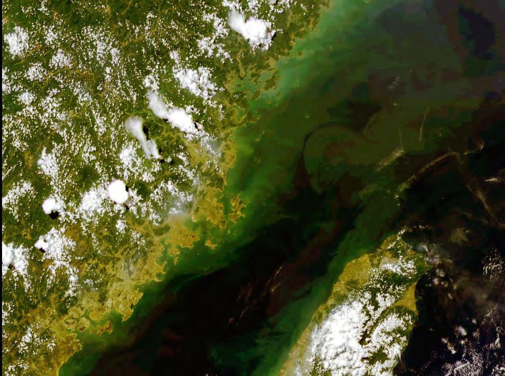
 Yangtze River, China")

19 Yangtze River, China (GOCI, ) Yangtze River, China (MODIS Aqua, ) R: 660 G: 555 B:490 R: 645 G: 555 B:469


20


21

22
23 Fully successful launch campaign of GOCI/COMS All functional tests for GOCI was successful. GOCI IOT for geometric performance verification is on-going Slot level radiometric discrepancy has been found during inorbit test We need more fine tuning of all algorithms GDPS Should be corrected/improved in some parts. (Atmospheric correction, BRDF, under water algorithms)
24


25 Two buoys and two ocean stations have already been constructed by KOON
26

27 Ieodo station is managed by NORI (Government offfice) KORDI : design, construction, installation, test NORI : operational work


28


29 26m L sky E d L wt
30

31
32 Chl-a(ug/l) Day


33


34
35 SeaWiFS MODIS GOCI HICO MERIS Application 411nm 412 nm Hyperspectr nm CDOM 443 nm 442 nm 443 nm al nm chlorophyll 487 nm 490 nm nm at 5.2 nm 490 nm Chl and other pigments 520 nm 530 nm Can match 510 nm turbidity 550 nm 547 nm 555 nm Any GOCI 560 nm Chl, suspended sediments channel 620 nm Suspended sediments 670 nm 665 nm 660 nm 665 nm Chl absorption 677 nm 680 nm nm Chl fluorescence 705 nm Blooms, Red edge nm 745 nm nm O 2 abs. ref., ocean Beyond 760 nm aerosols O 2 abs. Planned 775 nm Aerosols, vegetation Lifetime. 866 nm 865 nm 865 nm Aerosols over the ocean Little data 890 nm Water vapor reference In nm Water vapor absorption


36

37 Hanjin Co. 2,821to n 4,538to n Length ; 93.3m Width ; 15.6m Draft ; 5.60m Speed ; 11 knot Incheon Kwangyang Pusan Incheon
38 No international OC Cal/Val site in GOCI coverage Indirect method : Inter-satellite Cal Existing sites need to be stabilize for GOCI Cal/Val Our efforts (with KORDI) Supporting of International groups AERONET-OC site selection : Gageocho Station (with TriOS) Already registered to NASA Once started, termination is irreversible from David Antoine No land Cal/Val site in GOCI coverage No desert, ice, playa : uniform, wide, long term-radiometric stability Tidal flat (if possible) : uniform(except SMC), wide Hope to show you quantitative results in near future

39 Developed GOCI Public Website at KOSC using published and approved for distribution data, publications and presentations. KOSC GOCI Web site would be portal for data requests and distribution Data requests require proposal and data agreement signed by the requestor and their institution and approved by MLTM.
GOCI Status and Cooperation with CoastColour Project
 GOCI Status and Cooperation with CoastColour Project Joo-Hyung RYU Contribution from : KOSC colleaques Nov. 17, 2010 World 1 st GOCI/COMS Launch Campaign Launch Date : June 27 2010 Launch Vehicle : Ariane-V
1. INTRODUCTION. GOCI : Geostationary Ocean Color Imager
 1. INTRODUCTION The Korea Ocean Research and Development Institute (KORDI) releases an announcement of opportunity (AO) to carry out scientific research for the utilization of GOCI data. GOCI is the world
Updates on GOCI & GOCI-II projects
 Updates on GOCI & GOCI-II projects Young-Je Park, Wonkook Kim* Contributed by KOSC staff Korea Ocean Satellite Center (KOSC) Korea Institute of Ocean Science and Technology (KIOST) AWOC2015 and 12 th JKWOC
On the use of water color missions for lakes in 2021
 Lakes and Climate: The Role of Remote Sensing June 01-02, 2017 On the use of water color missions for lakes in 2021 Cédric G. Fichot Department of Earth and Environment 1 Overview 1. Past and still-ongoing
Futrajaya, Malaysia JULY 12, Jeong Heon SONG. Korea Aerospace Research Institution
 J P T M 2 0 1 1 Futrajaya, Malaysia JULY 12, 2011 Jeong Heon SONG Korea Aerospace Research Institution Outline Contribution of KARI Sentinel Asia / Data Provider Node International Charter KARI Space Activities
Light penetration within a clear water body. E z = E 0 e -kz
 THE BLUE PLANET 1 2 Light penetration within a clear water body E z = E 0 e -kz 3 4 5 Pure Seawater Phytoplankton b w 10-2 m -1 b w 10-2 m -1 b w, Morel (1974) a w, Pope and Fry (1997) b chl,loisel and
Light penetration within a clear water body. E z = E 0 e -kz
 THE BLUE PLANET 1 2 Light penetration within a clear water body E z = E 0 e -kz 3 4 5 6 Pure Seawater Phytoplankton b w 10-2 m -1 b w 10-2 m -1 b w, Morel (1974) a w, Pope and Fry (1997) b chl,loisel and
Theme: ocean colour observations from the geostationary orbit
 A new IOCCG working group Theme: ocean colour observations from the geostationary orbit Today (Nov 1 st, 2008):1 st Working group meeting, with the following goals: - Members of the WG meet and know better
NASA OBPG Satellite Ocean Color Update
 NASA OBPG Satellite Ocean Color Update Bryan Franz and the Ocean Biology Processing Group NASA Goddard Space Flight Center IOCS Meeting Ocean Color Research Team Meeting 18 May 2017, Lisbon, Portugal NASA
Recent developments in Deep Blue satellite aerosol data products from NASA GSFC
 Recent developments in Deep Blue satellite aerosol data products from NASA GSFC Andrew M. Sayer, N. Christina Hsu (PI), Corey Bettenhausen, Myeong-Jae Jeong Climate & Radiation Laboratory, NASA Goddard
MERIS instrument. Muriel Simon, Serco c/o ESA
 MERIS instrument Muriel Simon, Serco c/o ESA Workshop on Sustainable Development in Mountain Areas of Andean Countries Mendoza, Argentina, 26-30 November 2007 ENVISAT MISSION 2 Mission Chlorophyll case
Sustained Ocean Color Research and Operations
 Sustained Ocean Color Research and Operations What are the minimum requirements to continue the SeaWiFS/MODIS time-series? Based on a National Research Council report by the Ocean Studies Board May 2011
MERIS data access over diagnostic sites for calibration and validation purposes
 MERIS data access over diagnostic sites for calibration and validation purposes Philippe Goryl ESA / ESRIN Philippe.Goryl@esa.int Carsten Brockman Brockman Consult Workshop on Inter-Comparison of Large
ENMAP RADIOMETRIC INFLIGHT CALIBRATION, POST-LAUNCH PRODUCT VALIDATION, AND INSTRUMENT CHARACTERIZATION ACTIVITIES
 ENMAP RADIOMETRIC INFLIGHT CALIBRATION, POST-LAUNCH PRODUCT VALIDATION, AND INSTRUMENT CHARACTERIZATION ACTIVITIES A. Hollstein1, C. Rogass1, K. Segl1, L. Guanter1, M. Bachmann2, T. Storch2, R. Müller2,
Remote Sensing for Resource Management
 Remote Sensing for Resource Management Ebenezer Nyadjro US Naval Research Lab/UNO RMU Summer Program (July 31-AUG 4, 2017) Motivation Polluted Pra River Motivation. 3 Motivation Polluted Pra River Motivation.
Pléiades imagery for coastal and inland water applications
 Pléiades imagery for coastal and inland water applications Pléiades 2014-09-08 Quinten Vanhellemont & PONDER project 2017-10-20 dredging ship PONDER SR/00/325 «Ocean colour remote sensing» Remote sensing
Jeffrey H. Bowles, Wesley J. Moses, Gia M. Lamela, Richard Mied, Karen W. Patterson, and Ellen J. Wagner
 1 Jeffrey H. Bowles, Wesley J. Moses, Gia M. Lamela, Richard Mied, Karen W. Patterson, and Ellen J. Wagner and, Washington, D.C. from Center for Advanced Land Management Information Technologies (CALMIT),
3/31/03. ESM 266: Introduction 1. Observations from space. Remote Sensing: The Major Source for Large-Scale Environmental Information
 Remote Sensing: The Major Source for Large-Scale Environmental Information Jeff Dozier Observations from space Sun-synchronous polar orbits Global coverage, fixed crossing, repeat sampling Typical altitude
Evaluation and improvements of MERIS, OLCI and SLSTR Rrs in contrasted turbid waters
 Evaluation and improvements of MERIS, OLCI and SLSTR Rrs in contrasted turbid waters Jamet, C., H., Loisel, M.A. Mograne, D., Dessailly, X., Mériaux and A., Cauvin Laboratoire d Océanologie et de Géosciences
CLOUD SCREENING METHOD FOR OCEAN COLOR OBSERVATION BASED ON THE SPECTRAL CONSISTENCY
 CLOUD SCREENING METHOD FOR OCEAN COLOR OBSERVATION BASED ON THE SPECTRAL CONSISTENCY H. Fukushima a, K. Ogata a, M. Toratani a a School of High-technology for Human Welfare, Tokai University, Numazu, 410-0395
Radiometric Validation of Sentinel-3
 Radiometric Validation of Sentinel-3 by Kevin Ruddick, Dimitry Van Der Zande and Quinten Vanhellemont (RBINS, ODNature, REMSEM) Sentinel-2 Radiometric Validation of Sentinel-3 by Kevin Ruddick, Dimitry
UPDATE ON COMS PROGRAM
 Prepared by KMA Agenda Item: C.2 Discussed in Plenary UPDATE ON COMS PROGRAM This document is to update the COMS program as a part of CGMS-34-WMO-WP-25. Currently, the integration of COMS system has been
DEVELOPING AN OCEAN COLOUR SERVICE SUPPORTING GLOBAL CARBON-CYCLE RESEARCH AND OPERATIONAL OCEANOGRAPHY
 DEVELOPING AN OCEAN COLOUR SERVICE SUPPORTING GLOBAL CARBON-CYCLE RESEARCH AND OPERATIONAL OCEANOGRAPHY Odile Fanton d'andon 1, Samantha Lavender 2, Antoine Mangin 1 and Simon Pinnock 3 (1) ACRI-ST, France
OVERVIEW OF KOMPSAT-3A CALIBRATION AND VALIDATION
 OVERVIEW OF KOMPSAT-3A CALIBRATION AND VALIDATION DooChun Seo 1, GiByeong Hong 1, ChungGil Jin 1, DaeSoon Park 1, SukWon Ji 1 and DongHan Lee 1 1 KARI(Korea Aerospace Space Institute), 45, Eoeun-dong,
The Hyperspectral Imager for the Coastal Ocean (HICO): Sensor and Data Processing Overview
: Sensor and Data Processing Overview") The Hyperspectral Imager for the Coastal Ocean (HICO): Sensor and Data Processing Overview Curtiss O. Davis Oregon State University, Corvallis, OR, USA Michael Corson and Robert Lucke Naval Research Laboratory,
The Hyperspectral Imager for the Coastal Ocean (HICO): Sensor and Data Processing Overview Curtiss O. Davis Oregon State University, Corvallis, OR, USA Michael Corson and Robert Lucke Naval Research Laboratory,
Observing Nightlights from Space with TEMPO James L. Carr 1,Xiong Liu 2, Brian D. Baker 3 and Kelly Chance 2
 Observing Nightlights from Space with TEMPO James L. Carr 1,Xiong Liu 2, Brian D. Baker 3 and Kelly Chance 2 September 27, 2016 1 Carr Astronautics Corp., Greenbelt, MD, USA jcarr@carrastro.com 2 Harvard-Smithsonian
(HICO): Sensor and Data Processing Overview
: Sensor and Data Processing Overview") The Hyperspectral Imager for the Coastal Ocean (HICO): Sensor and Data Processing Overview Curtiss O. Davis Oregon State t University, it Corvallis, OR, USA Michael Corson and Robert Lucke Naval Research
The Hyperspectral Imager for the Coastal Ocean (HICO): Sensor and Data Processing Overview Curtiss O. Davis Oregon State t University, it Corvallis, OR, USA Michael Corson and Robert Lucke Naval Research
The Global Imager (GLI)
") The Global Imager (GLI) Launch : Dec.14, 2002 Initial check out : to Apr.14, 2003 (~L+4) First image: Jan.25, 2003 Second image: Feb.6 and 7, 2003 Calibration and validation : to Dec.14, 2003(~L+4) for
The Global Imager (GLI) Launch : Dec.14, 2002 Initial check out : to Apr.14, 2003 (~L+4) First image: Jan.25, 2003 Second image: Feb.6 and 7, 2003 Calibration and validation : to Dec.14, 2003(~L+4) for
AVHRR/3 Operational Calibration
 AVHRR/3 Operational Calibration Jörg Ackermann, Remote Sensing and Products Division 1 Workshop`Radiometric Calibration for European Missions, 30/31 Aug. 2017`,Frascati (EUM/RSP/VWG/17/936014) AVHRR/3
Present and future of marine production in Boka Kotorska
 Present and future of marine production in Boka Kotorska First results from satellite remote sensing for the breeding areas of filter feeders in the Bay of Kotor INTRODUCTION Environmental monitoring is
JRC CAL/VAL Giuseppe Zibordi
 JRC CAL/VAL Giuseppe Zibordi in collaboration with JRC-IES Marine Team and GSFC-AERONET Team OCVC-Workshop, Ispra, October 20, 2010 1 Reduction of uncertainties in current remote sensing coastal products
Characterization of the atmospheric aerosols and the surface radiometric properties in the AGRISAR Campaign
 Characterization of the atmospheric aerosols and the surface radiometric properties in the AGRISAR Campaign V. Estellés Solar Radiation Unit Universitat de València T. Ruhtz, P. Zieger, S. Stapelberg Institute
Comparative Analysis of GOCI Ocean Color Products
 Sensors 015, 15, 5703-5715; doi:10.3390/s15105703 Article OPEN ACCESS sensors ISSN 144-80 www.mdpi.com/journal/sensors Comparative Analysis of GOCI Ocean Color Products Ruhul Amin 1, *, Mark David Lewis,
DEVELOPMENT OF THE NEW GENERATION OF GEOSTATIONARY OCEAN COLOR IMAGER
 DEVELOPMENT OF THE NEW GENERATION OF GEOSTATIONARY OCEAN COLOR IMAGER Pierre Coste 1, Franck Larnaudie 1, Philippe Luquet 1, Haengpal Heo 2, Junpyung Jung 2, Gmsil Kang 2, Sangyoun Shin 2, Sangsoon Yong
Kazuhiro TANAKA GCOM project team/jaxa April, 2016
 Kazuhiro TANAKA GCOM project team/jaxa April, 216 @ SPIE Asia-Pacific 216 at New Dehli, India 1 http://suzaku.eorc.jaxa.jp/gcom_c/index_j.html GCOM mission and satellites SGLI specification and IRS overview
IKONOS High Resolution Multispectral Scanner Sensor Characteristics
 High Spatial Resolution and Hyperspectral Scanners IKONOS High Resolution Multispectral Scanner Sensor Characteristics Launch Date View Angle Orbit 24 September 1999 Vandenberg Air Force Base, California,
NORMALIZING ASTER DATA USING MODIS PRODUCTS FOR LAND COVER CLASSIFICATION
 NORMALIZING ASTER DATA USING MODIS PRODUCTS FOR LAND COVER CLASSIFICATION F. Gao a, b, *, J. G. Masek a a Biospheric Sciences Branch, NASA Goddard Space Flight Center, Greenbelt, MD 20771, USA b Earth
Updates from the IMOS Ocean Colour Sub-Facility and the ANMN Bio-Optics Project
 Suomi NPP VIIRS Austral Summer 21 Dec - 20 Mar 2012 Updates from the IMOS Ocean Colour Sub-Facility and the ANMN Bio-Optics Project Schroeder T. 7 March 2016 IMOS QC-Summit, Hobart CSIRO OCEANS & ATMOSPHERE
Copernicus Introduction Lisbon, Portugal 13 th & 14 th February 2014
 Copernicus Introduction Lisbon, Portugal 13 th & 14 th February 2014 Contents Introduction GMES Copernicus Six thematic areas Infrastructure Space data An introduction to Remote Sensing In-situ data Applications
Introduction to image processing for remote sensing: Practical examples
 Università degli studi di Roma Tor Vergata Corso di Telerilevamento e Diagnostica Elettromagnetica Anno accademico 2010/2011 Introduction to image processing for remote sensing: Practical examples Dr.
Railroad Valley Playa for use in vicarious calibration of large footprint sensors
 Railroad Valley Playa for use in vicarious calibration of large footprint sensors K. Thome, J. Czapla-Myers, S. Biggar Remote Sensing Group Optical Sciences Center University of Arizona Introduction P
35017 Las Palmas de Gran Canaria, Spain Santa Cruz de Tenerife, Spain ABSTRACT
 Atmospheric correction models for high resolution WorldView-2 multispectral imagery: A case study in Canary Islands, Spain. J. Martin* a F. Eugenio a, J. Marcello a, A. Medina a, Juan A. Bermejo b a Institute
RECENT DYNAMICS OF SUBMERGED SHOALS AND CHANNELS AROUND THE KERKENNAH ARCHIPELAGO (TUNISIA) FROM LANDSAT TM AND MODIS
 FROM LANDSAT TM AND MODIS") 2 nd International Conference - Water resources and wetlands. 11-13 September, 2014 Tulcea (Romania); Available online at http://www.limnology.ro/water2014/proceedings.html Editors: Petre Gâştescu ; Włodzimierz
2 nd International Conference - Water resources and wetlands. 11-13 September, 2014 Tulcea (Romania); Available online at http://www.limnology.ro/water2014/proceedings.html Editors: Petre Gâştescu ; Włodzimierz
Passive Microwave Sensors LIDAR Remote Sensing Laser Altimetry. 28 April 2003
 Passive Microwave Sensors LIDAR Remote Sensing Laser Altimetry 28 April 2003 Outline Passive Microwave Radiometry Rayleigh-Jeans approximation Brightness temperature Emissivity and dielectric constant
MERIS US Workshop. Instrument Overview. Steven Delwart
 MERIS US Workshop Instrument Overview Steven Delwart ENVISAT Acknowledgement To the ENVISAT Team & MERIS Instrument Engineers Jean-Loup Bezy George Gourmelon ENVISAT- MERIS 120M 200 Kg 1m 3 175 W MERIS
PLANET SURFACE REFLECTANCE PRODUCT
 PLANET SURFACE REFLECTANCE PRODUCT FEBRUARY 2018 SUPPORT@PLANET.COM PLANET.COM VERSION 1.0 TABLE OF CONTENTS 3 Product Description 3 Atmospheric Correction Methodology 5 Product Limitations 6 Product Assessment
Coastal Waters Imaging and Proposed Next Steps
 SU_2/20/2006_Davis.1 Coastal Waters Imaging and Proposed Next Steps Curtiss O. Davis College of Oceanic and Atmospheric Sciences Oregon State University, Corvallis, Oregon 97331 541-737-4432 cdavis@coas.oregonstate.edu
Lab 1: Introduction to MODIS data and the Hydra visualization tool 21 September 2011
 WMO RA Regional Training Course on Satellite Applications for Meteorology Cieko, Bogor Indonesia 19-27 September 2011 Kathleen Strabala University of Wisconsin-Madison, USA kathy.strabala@ssec.wisc.edu
Upcoming European Missions
 Upcoming European Missions Carsten Brockmann Brockmann Consult GmbH With contributions from Criag Donlon, Peter Regner, Bianca Hoersch, Ferran Gascon (all ESA) Charly Kaufmann (GFZ Potsdam), Godela Rossner
2 nd Research Announcement on the Earth Observations
 2 nd Research Announcement on the Earth Observations JAXA Satellite Project Research GCOM-W, GCOM-C, GPM, ALOS-2, ALOS-3, ALOS-4 MOLI, EarthCARE, AMSR3 Issued: October 17, 2018 Proposal Due: November 30,
Radiometric performance of Second Generation Global Imager (SGLI) using integrating sphere
 using integrating sphere") Radiometric performance of Second Generation Global Imager (SGLI) using integrating sphere Taichiro Hashiguchi, Yoshihiko Okamura, Kazuhiro Tanaka, Yukinori Nakajima Japan Aerospace Exploration Agency
Radiometric performance of Second Generation Global Imager (SGLI) using integrating sphere Taichiro Hashiguchi, Yoshihiko Okamura, Kazuhiro Tanaka, Yukinori Nakajima Japan Aerospace Exploration Agency
Sentinel-3 OLCI and SLSTR
 Sentinel-3 OLCI and SLSTR Craig Donlon ESA/ESTEC, Mission Science Division B. Berruti, J. Frerick, C. Mavrocordatos, J. Nieke, H. Rebhan, J. Stroede and the S3 Team, European Space Agency, ESTEC, Keplerlaan
GOES-16 ABI On-Orbit Performance
 GOES-16 ABI On-Orbit Performance Xiangqian WU b, Fangfang YU a, Vladimir KONDRATOVICH a, Boryana EFREMOVA a, Xi SHAO a, Robert IACOVAZZI a, Haifeng QIAN a, Hye Lim YOO a, Li ZHU a, and Changyong CAO b
The coastal challenge. Dr Samantha Lavender
 The coastal challenge Dr Samantha Lavender SEOES & Marine Institute, University of Plymouth ARGANS Limited Tamar Science Park, Plymouth s.lavender@plymouth.ac.uk samantha.lavender@argans.co.uk http://www.research.plymouth.ac.uk/geomatics/
Multi-sensor data base over desert sites for calibration purpose. P. Henry ¹, X. Briottet ², C. Miesch ², F. Cabot ¹ ¹CNES, ²ONERA
 Multi-sensor data base over desert sites for calibration purpose P. Henry ¹, X. Briottet ², C. Miesch ², F. Cabot ¹ ¹CNES, ²ONERA Outline Introduction SADE database Calibration method Some results Desert
Towards the Intercalibration of EO medium resolution multi-spectral imagers : MEREMSII Final Report Executive Summary
 Page : i Towards the Intercalibration of EO medium resolution multi-spectral imagers MEREMSII FINAL REPORT EXECUTIVE SUMMARY ESA contract: 4000101605/10/NL/CBi ARGANS Reference: 003-009 Date: 14 January
Hyperspectral Imaging of River Systems
 DISTRIBUTION STATEMENT A. Approved for public release; distribution is unlimited. Hyperspectral Imaging of River Systems Curtiss O. Davis College of Oceanic and Atmospheric Sciences 104 COAS Admin, Bldg
DESIS Applications & Processing Extracted from Teledyne & DLR Presentations to JACIE April 14, Ray Perkins, Teledyne Brown Engineering
 DESIS Applications & Processing Extracted from Teledyne & DLR Presentations to JACIE April 14, 2016 Ray Perkins, Teledyne Brown Engineering 1 Presentation Agenda Imaging Spectroscopy Applications of DESIS
LANDSAT 8 Level 1 Product Performance
 Réf: IDEAS-TN-10-CyclicReport LANDSAT 8 Level 1 Product Performance Cyclic Report Month/Year: May 2015 Date: 25/05/2015 Issue/Rev:1/0 1. Scope of this document On May 30, 2013, data from the Landsat 8
The OCR-VC addresses the following strategic objectives towards these goals:
 TERMS OF REFERENCE FOR THE CEOS OCEAN COLOR RADIOMETRY VIRTUAL CONSTELLATION VERSION 3.1 LAST MODIFIED: 19 DECEMBER 2013 CONSTELLATION NAME: Ocean Color Radiometry Virtual Constellation (OCR-VC) MISSION
Lecture 6: Multispectral Earth Resource Satellites. The University at Albany Fall 2018 Geography and Planning
 Lecture 6: Multispectral Earth Resource Satellites The University at Albany Fall 2018 Geography and Planning Outline SPOT program and other moderate resolution systems High resolution satellite systems
Sea to Sky: The NASA Plankton, Aerosol, Cloud, ocean Ecosystem (PACE) mission
 mission") Sea to Sky: The NASA Plankton, Aerosol, Cloud, ocean Ecosystem (PACE) mission Jeremy Werdell PACE Project Scientist NASA Goddard Space Flight Center Robert H. Goddard Memorial Symposium 9 March 2017, Greenbelt,
Sea to Sky: The NASA Plankton, Aerosol, Cloud, ocean Ecosystem (PACE) mission Jeremy Werdell PACE Project Scientist NASA Goddard Space Flight Center Robert H. Goddard Memorial Symposium 9 March 2017, Greenbelt,
Geospatial Vision and Policies Korean Industry View 26 November, 2014 SI Imaging Services
 Geospatial Vision and Policies Korean Industry View 26 November, 2014 SI Imaging Services Distribution Limitation, SI Imaging Services Proprietary Data : The data contained in this document, without the
Evaluation of FLAASH atmospheric correction. Note. Note no SAMBA/10/12. Authors. Øystein Rudjord and Øivind Due Trier
 Evaluation of FLAASH atmospheric correction Note Note no Authors SAMBA/10/12 Øystein Rudjord and Øivind Due Trier Date 16 February 2012 Norsk Regnesentral Norsk Regnesentral (Norwegian Computing Center,
The studies began when the Tiros satellites (1960) provided man s first synoptic view of the Earth s weather systems.
 provided man s first synoptic view of the Earth s weather systems.") Remote sensing of the Earth from orbital altitudes was recognized in the mid-1960 s as a potential technique for obtaining information important for the effective use and conservation of natural resources.
Remote sensing of the Earth from orbital altitudes was recognized in the mid-1960 s as a potential technique for obtaining information important for the effective use and conservation of natural resources.
XSAT Ground Segment at CRISP
 XSAT Ground Segment at CRISP LIEW Soo Chin Head of Research, CRISP http://www.crisp.nus.edu.sg 5 th JPTM for Sentinel Asia Step-2, 14-16 Nov 2012, Daejeon, Korea Centre for Remote Imaging, Sensing and
Ground Truth for Calibrating Optical Imagery to Reflectance
 Visual Information Solutions Ground Truth for Calibrating Optical Imagery to Reflectance The by: Thomas Harris Whitepaper Introduction: Atmospheric Effects on Optical Imagery Remote sensing of the Earth
The Moderate Resolution Imaging Spectroradiometer (MODIS): Potential Applications for Climate Change and Modeling Studies
: Potential Applications for Climate Change and Modeling Studies") The Moderate Resolution Imaging Spectroradiometer (MODIS): Potential Applications for Climate Change and Modeling Studies Menas Kafatos, CEOSR, George Mason University Jim McManus, CEOSR, GMU and GES DISC
The Moderate Resolution Imaging Spectroradiometer (MODIS): Potential Applications for Climate Change and Modeling Studies Menas Kafatos, CEOSR, George Mason University Jim McManus, CEOSR, GMU and GES DISC
ASTER ADVANCED SPACEBORNE THERMAL EMISSION AND REFLECTION RADIOMETER
 ASTER ADVANCED SPACEBORNE THERMAL EMISSION AND REFLECTION RADIOMETER Front Cover image: Simulated ASTER images of Death Valley, California. The visible image (left) shows vegetation in red, salt deposits
Chapter 5. Preprocessing in remote sensing
 Chapter 5. Preprocessing in remote sensing 5.1 Introduction Remote sensing images from spaceborne sensors with resolutions from 1 km to < 1 m become more and more available at reasonable costs. For some
Interpreting land surface features. SWAC module 3
 Interpreting land surface features SWAC module 3 Interpreting land surface features SWAC module 3 Different kinds of image Panchromatic image True-color image False-color image EMR : NASA Echo the bat
RAMSES. A modular multispectral radiometer for light measurements in the UV and VIS
 RAMSES A modular multispectral radiometer for light measurements in the UV and VIS Rüdiger Heuermann a, Rainer Reuter b and Rainer Willkomm a a TriOS Mess- und Datentechnik GmbH, Oldenburg, Germany b Fachbereich
6th Beirut Water Week 27th February - 1st March 2017
 Assessment of chlorophyll-a concentration using Landsat Operational Land Imager in Lake Qaraoun, Lebanon Ali Fadel 6th Beirut Water Week 27th February - 1st March 2017 Introduction & problematic Worldwide
Fundamentals of Remote Sensing
 Climate Variability, Hydrology, and Flooding Fundamentals of Remote Sensing May 19-22, 2015 GEO-Latin American & Caribbean Water Cycle Capacity Building Workshop Cartagena, Colombia 1 Objective To provide
All rights reserved. ENVI, IDL and Jagwire are trademarks of Exelis, Inc. All other marks are the property of their respective owners.
 Services Engine The HICO Online Processing System: A Web-Enabled Coastal Hyperspectral Imagery Processing System All rights reserved. ENVI, IDL and Jagwire are trademarks of Exelis, Inc. All other marks
ASSESSMENT OF SENTINEL-3/OLCI SUB-PIXEL VARIABILITY AND PLATFORM IMPACT USING LANDSAT-8/OLI
 ASSESSMENT OF SENTINEL-3/OLCI SUB-PIXEL VARIABILITY AND PLATFORM IMPACT USING LANDSAT-8/OLI Quinten Vanhellemont (1), Kevin Ruddick (1) (1) Royal Belgian Institute of Natural Sciences (RBINS), Operational
WATER SERVICE - COASTAL PRODUCTS PRODUCT DESCRIPTION
 WATER SERVICE - COASTAL PRODUCTS PRODUCT DESCRIPTION Delivery 30.01.2015 Kerstin Stelzer, Ana Ruescas, Uwe Lange - Brockmann Consult GmbH Overview The products within the water quality service provide
NRL SSC HICO Article for Oceans 09 Conference
 NRL SSC HICO Article for Oceans 09 Conference Title: The Hyperspectral Imager for the Coastal Ocean (HICO): Sensor and Data Processing Overview Abstract M.D. Lewis, R.W. Gould, Jr., R.A. Arnone, P.E. Lyon,
Sea surface temperature observation through clouds by the Advanced Microwave Scanning Radiometer 2
 Sea surface temperature observation through clouds by the Advanced Microwave Scanning Radiometer 2 Akira Shibata Remote Sensing Technology Center of Japan (RESTEC) Tsukuba-Mitsui blds. 18F, 1-6-1 Takezono,
ROSCOSMOS Agency Report. 36 th CEOS WGCV Plenary May 2013, Shanghai, China
 ROSCOSMOS Agency Report 36 th CEOS WGCV Plenary 13-17 May 2013, Shanghai, China Denisov Pavel «Research Center for Earth Operative Monitoring» Joint-Stock Company «Russian Space Systems» 1 PURPOSE AND
METimage Calibration & Performance Verification. Xavier Gnata ICSO 2016
 METimage Calibration & Performance Verification Xavier Gnata ICSO 2016 METimage factsheet Mission Passive imaging radiometer (multi-spectral) 20 spectral channels (443 13.345nm) Global coverage within
Research Announcement
 VENμS: Joint Israeli French Micro- Spacecraft for Earth Observation Mission VENμS Vegetation and Environment monitoring on a New Micro Satellite Research Announcement Outline proposal due: June 26, 2006
Summary Recommendations from IOCS Splinter Sessions
 Summary Recommendations from IOCS Splinter Sessions Recommendations from the Splinter Session on Advances in Atmospheric Correction of Satellite Ocean Colour Imagery (Chairs: Robert Frouin, Sean Bailey
Int n r t o r d o u d c u ti t on o n to t o Remote Sensing
 Introduction to Remote Sensing Definition of Remote Sensing Remote sensing refers to the activities of recording/observing/perceiving(sensing)objects or events at far away (remote) places. In remote sensing,
CHAPTER --'3 DATA DESCRIPTION
 CHAPTER --'3 DATA DESCRIPTION 37 3.1 INTRODUCTION In chapter 2 different techniques used for the study of polar cryosphere like passive and active remote sensing, altimetry and scatterometry are described.
Compact High Resolution Imaging Spectrometer (CHRIS) siraelectro-optics
 siraelectro-optics") Compact High Resolution Imaging Spectrometer (CHRIS) Mike Cutter (Mike_Cutter@siraeo.co.uk) Summary CHRIS Instrument Design Instrument Specification & Performance Operating Modes Calibration Plan Data
Compact High Resolution Imaging Spectrometer (CHRIS) Mike Cutter (Mike_Cutter@siraeo.co.uk) Summary CHRIS Instrument Design Instrument Specification & Performance Operating Modes Calibration Plan Data
VIIRS Cloud-Free Compositing For Nighttime Lights
 VIIRS Cloud-Free Compositing For Nighttime Lights Kimberly Baugh, CIRES University of Colorado Feng Chi Hsu, CIRES University of Colorado Mikhail Zhizhin, CIRES University of Colorado Tilottama Ghosh,
Aerosol Assessement. an update. Jeff Reid and partners
 Aerosol Assessement an update Jeff Reid and partners the first page A Critical Review of the Efficacy of Commonly Used Aerosol Optical Thickness Retrievals literature assessment report to the Radiation
Status of MODIS, VIIRS, and OLI Sensors
 Status of MODIS, VIIRS, and OLI Sensors Xiaoxiong (Jack) Xiong, Jim Butler, and Brian Markham Code 618.0 NASA/GSFC, Greenbelt, MD 20771, USA Acknowledgements: NASA MODIS Characterization Support Team (MCST)
Inter comparison of Terra and Aqua MODIS Reflective Solar Bands Using Suomi NPP VIIRS
 Inter comparison of Terra and Aqua Reflective Solar Bands Using Suomi NPP VIIRS Slawomir Blonski, * Changyong Cao, Sirish Uprety, ** and Xi Shao * NOAA NESDIS Center for Satellite Applications and Research
RADIATION BUDGET INSTRUMENT (RBI): FINAL DESIGN AND INITIAL EDU TEST RESULTS
: FINAL DESIGN AND INITIAL EDU TEST RESULTS") Place image here (10 x 3.5 ) RADIATION BUDGET INSTRUMENT (RBI): FINAL DESIGN AND INITIAL EDU TEST RESULTS RONALD GLUMB, JAY OVERBECK, CHRISTOPHER LIETZKE, JOHN FORSYTHE, ALAN BELL, AND JASON MILLER NON-EXPORT
Place image here (10 x 3.5 ) RADIATION BUDGET INSTRUMENT (RBI): FINAL DESIGN AND INITIAL EDU TEST RESULTS RONALD GLUMB, JAY OVERBECK, CHRISTOPHER LIETZKE, JOHN FORSYTHE, ALAN BELL, AND JASON MILLER NON-EXPORT
Sentinel-2 Products and Algorithms
 Sentinel-2 Products and Algorithms Ferran Gascon (Sentinel-2 Data Quality Manager) Workshop Preparations for Sentinel 2 in Europe, Oslo 26 November 2014 Sentinel-2 Mission Mission Overview Products and
Two-linear-polarization measurement of O 2 A band with TANSO-FTS onboard GOSAT
 Remote sensing in the O 2 A band Two-linear-polarization measurement of O 2 A band with TANSO-FTS onboard GOSAT July 7, 2016, De Bilt Akihiko Kuze, Hiroshi Suto, Kei Shiomi, Nobuhiro Kikuchi, Makiko Hashimoto
Exelis Visual Information Solutions
 Craig Cowan, Defence and Security Business Development craig.cowan@exelisinc.com www.exelisvis.eu Exelis Visual Information Solutions Hyperspectral Imagery Exploitation Sensors Symposium, Stockholm 10
ACOLITE FOR SENTINEL-2: AQUATIC APPLICATIONS OF MSI IMAGERY
 ACOLITE FOR SENTINEL-2: AQUATIC APPLICATIONS OF MSI IMAGERY Quinten Vanhellemont (1) and Kevin Ruddick (1) (1) Royal Belgian Institute for Natural Sciences, Operational Directorate Natural Environment,
Feedback on Level-1 data from CCI projects
 Feedback on Level-1 data from CCI projects R. Hollmann, Cloud_cci Background Following this years CMUG meeting & Science Leader discussion on Level 1 CCI projects ingest a lot of level 1 satellite data
Remote Sensing Mapping of Turbidity in the Upper San Francisco Estuary. Francine Mejia, Geography 342
 Remote Sensing Mapping of Turbidity in the Upper San Francisco Estuary Francine Mejia, Geography 342 Introduction The sensitivity of reflectance to sediment, chlorophyll a, and colored DOM (CDOM) in the
Looking at 637 nm VIIRS band, S-NPP
 Looking at 637 nm VIIRS band, S-NPP bguenther@stellarsolutions.com (Sharpening I1) B. GUENTHER STELLAR SOLUTIONS, INC NOAA-JPSS 1 I am looking at houses and have a desire to know how much living area this
NOAA JPSS and GOES Fire Products R. Bradley Pierce and Shobha Kondragunta NOAA/NESDIS/STAR
 NOAA JPSS and GOES Fire Products R. Bradley Pierce and Shobha Kondragunta NOAA/NESDIS/STAR Outline VIIRS Aerosol Optical Depth and Fire Radiative Power ABI Aerosol Optical Depth and Fire Radiative Power
SEN3APP Stakeholder Workshop, Helsinki Yrjö Rauste/VTT Kaj Andersson/VTT Eija Parmes/VTT
 Optical Products from Sentinel-2 and Suomi- NPP/VIIRS SEN3APP Stakeholder Workshop, Helsinki 19.11.2015 Yrjö Rauste/VTT Kaj Andersson/VTT Eija Parmes/VTT Structure of Presentation High-resolution data