CALMIT Field Program. Center for Advanced Land Management Information Technologies (CALMIT) University of Nebraska Lincoln
|
|
|
- Buddy Edwards
- 5 years ago
- Views:
Transcription


 University")
1 CALMIT Field Program Center for Advanced Land Management Information Technologies (CALMIT) University of Nebraska Lincoln
2 Field Program: Three Areas Agriculture Surface Waters Coastal / Marine
3 1) Agriculture Biophysical Measurements: Vegetation Fraction Leaf Area Pigment Type and Density Leaf-Water Content Primary Productivity / Biomass Absorbed Photosynthetically Active Radiation


4 CALMIT Field Facility Note aircraft-calibration targets on concrete strip (above)
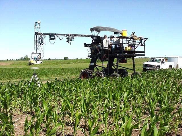
5 Goliath
6 Goliath Specifications All terrain (tracked wheels) Boom height = 10.5m (with full rotation) Boom length = 3.8m stowed; 12m extended Platform height = approx. 2m Platform width = 2.6 x 3m Passengers = driver + 4 Wheel spacing for standard 76.2 cm (30- inch) rows

7 Goliath is Mobile
8 Spectroradiometers Available on Goliath Dual Spectron SE-590 s Dual Ocean Optics USB-2000 s ASD-FR
 256 channels;")
9 Spectroradiometers Spectron SE-590 (2) 256 channels; nm
 2150 channels; 350-2500")
10 Spectroradiometers ASD Field Spec - FR (2) 2150 channels; nm

 irradiance and upwelling (target)")
11 Spectroradiometers Ocean Optics USB2000 (4) 2048 Channels, nm Dual systems allow simultaneous capture of downwelling (sky) irradiance and upwelling (target) radiance

12 Dual Fibers Facilitate Data Collection Under Rapidly Changing Illumination Conditions

13 Other Sensors on Goliath Canon digital-video camera Linear Laboratories infrared thermometer P-band Radar Scatterometer


")
14 Vegetation Fraction: Digital Camera V8 (19 June) V12 (6 July) R2 (28 July) R5 (20 August)

15 Early Season 30 May 28, _194N-S 104-2_194N-S _194N-S _194N-S _194N- S Wavelength (nm)

16 Mid-Season 60 July 21, _194N-S 304-2_194N-S _194N-S 304-4_194N-S Wavelength (nm)

17 Late Season August 18, _194N-S 204-2_194N-S _194N-S _194N-S Wavelength (nm)
18 Estimating Vegetation Fraction 0.6 Vegetation Fraction-Estimated VARI R 2 = Vegetation Fraction-Measured

19 Other Systems on Goliath Real-time DGPS Wireless Internet


20 Other Field Instruments UniSpec 256 Channels, nm Leaf Clip Operates with internal light source

21 University of Nebraska Carbon Sequestration Program Project Study Teams: Micrometeorological (CO 2 and H 2 O Vapor Fluxes) Soil Water Balance Soil C Plant C Assimilation NO 2 and CH 4 Flux Leaf Level Remote Sensing Canopy Level Remote Sensing Technology Design & Adoption
22 Seasonal VARI Irrigated and Non-Irrigated Corn June 6 through September Irrigated Corn VARI Non-Irrigated Corn /29/0106/18/0107/08/0107/28/0108/17/0109/06/0109/26/0110/16/01 Date
23 Why Use Goliath? Reflectance, % July 3, Carbon 3 Measurements from Goliath Platform
24 Why Use Goliath? 8 6 July 3, Carbon-3. Handheld measurements

25 Hercules (2003 Field Season)

26 2) Surface Waters: Mesocosms
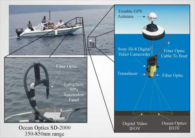
27

28 Surface Waters: Macrocosms

29 Underwater Light Fields
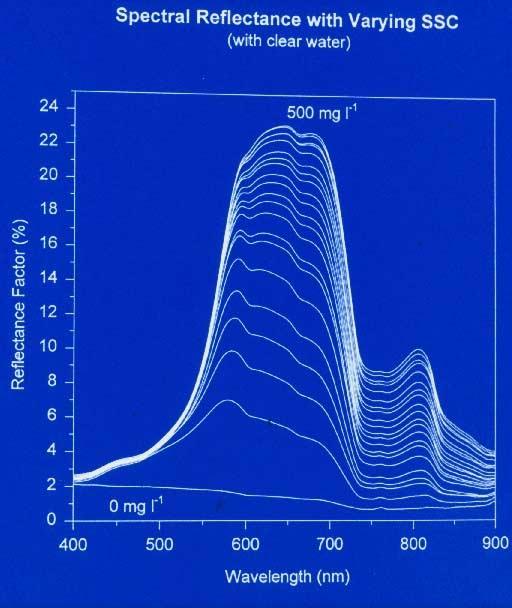
30 Okoboji Lakes (20 Sep 01) Reflectance, % mg/m Reflectance, % mg/m Wavelength, nm Wavelength, nm West Okoboji East Okoboji

31 Examples of Ancillary Data Sechi Disk Pigments» Chlorophyll» Carotenoids» Phycocyanin Phytoplankton Densities Turbidity Non-Organic Solids

32 Classified AISA Image

33 Coastal / Marine Roatan Island, Honduras
34 The Bob Technology

35 Remote Sensing of Corals

36 Video of Coral Features Scanned
37 Coral Spectra 100 SELECTED CLOSE RANGE SPECTRA ROATAN ISLAND, HONDURAS PERCENT REFLECTANCE Montastrea annularis 2 - Porites asteroides 3 - Acropora palmata 4 - Millepora complanta 5 - SAND BOTTTOM WAVELENGTH (nm)

38 Traditional Calibration
39 Dual Fibers Collecting spectra on a coral reef: Roatan Island, Honduras (March, 2002)


40 Using Dual Spectoradiometers for Hyperspectral Data Collection Land Lakes Underwater
41 Advantage Allows for data collection under most irradiance conditions Method is not valid if the irradiance changes during the scan time of the instruments (Usually 5 to 20 sec)

42 Hardware Requirements Two similar spectroradiometers
43 Hardware Requirements Two similar spectroradiometers Hemispherical cosine corrected optic
44 Hardware Requirements Two similar spectroradiometers Hemispherical cosine corrected optic Cables, power supplies, fibers, etc.
45 Hardware Requirements Two similar spectroradiometers Hemispherical cosine corrected optic Cables, power supplies, fibers, etc. Calibrated reflectance standard

46 Computer Additional Requirements
47 Additional Requirements Computer Spectral calibration of instruments
48 Additional Requirements Computer Spectral calibration of instruments Software for acquisition & processing
49 Additional Requirements Computer Spectral calibration of instruments Software for acquisition & processing Radiometric calibration optional Not necessary for reflectance Needed for radiance/irradiance
50 Method Near simultaneous data acquisition from both instruments Downwelling and upwelling radiation Instruments have different integration times
51 Method Near simultaneous data acquisition from both instruments Downwelling and upwelling radiation Instruments have different integration times Spectral channels of downwelling instrument interpolated To match channels of upwelling instrument
52 Method Near simultaneous data acquisition from both instruments Downwelling and upwelling radiation Instruments have different integration times Spectral channels of downwelling instrument interpolated To match channels of upwelling instrument Ratio of upwelling divided by downwelling is calculated
53 Method Near simultaneous data acquisition from both instruments Downwelling and upwelling radiation Instruments have different integration times Spectral channels of downwelling instrument interpolated To match channels of upwelling instrument Ratio of upwelling divided by downwelling is calculated Use scans of calibration panel to correct all other scans Panel reflectance is known A correction factor (CF) is calculated for each channel CF applied to upwelling/downwelling ratio of each scan
54 Corn & Soybeans May 21, % Reflectance Wavelength (nm) Allows calibration scans to be compared
55 Corn & Soybeans June 21, % Reflectance Wavelength (nm) Correction factors calculated for each channel based on the median value of the calibration scans for that channel
56 Corn & Soybeans July 23, % Reflectance Wavelength (nm) Correction factors applied to all scans

57 UNL Field-Radar System (EE Dept.)

58 Radar Measurements of Wetlands

59 Radar in the Field: Wetlands

60 Field Program: One Part of System

61
Spectral Reflectance Sensor SRS-NDVI
 The Spectral Reflectance Sensor NDVI continuously monitors the NDVI of our plant canopy. Measure NDVI or PRI vegetation indices at the plot or plant stand scale. Non-destructive sampling of canopy greenup,
Multiplatform Remote Sensing for Coral Reef Community Assessment
 Multiplatform Remote Sensing for Coral Reef Community Assessment Quinta Reunión Nacional de Percepción Remota y Sistemas de Información Geográfica en Puerto Rico September 27, 2007 Roy A. Armstrong, Ph.
QUANTITATIVE GLOBAL MAPPING OF TERRESTRIAL VEGETATION PHOTOSYNTHESIS: THE FLUORESCENCE EXPLORER (FLEX) MISSION
 MISSION") 2017 IEEE International Geoscience and Remote Sensing Symposium July 23 28, 2017 Fort Worth, Texas, USA Session MO3.L12 - International Spaceborne Imaging Spectroscopy Missions: Updates and News I QUANTITATIVE
2017 IEEE International Geoscience and Remote Sensing Symposium July 23 28, 2017 Fort Worth, Texas, USA Session MO3.L12 - International Spaceborne Imaging Spectroscopy Missions: Updates and News I QUANTITATIVE
Measurement and Measurement Error of Light Used for Photosynthesis & Plant Growth Richard Garcia April 20, 2010
 TRANSCRIPT SLIDE 1 [00:01] Thanks Ashlee, good afternoon from LI-COR Biosciences here in Lincoln, Nebraska. Thanks for joining us. Probably the most important process on our planet, is Photosynthesis and
Jeffrey H. Bowles, Wesley J. Moses, Gia M. Lamela, Richard Mied, Karen W. Patterson, and Ellen J. Wagner
 1 Jeffrey H. Bowles, Wesley J. Moses, Gia M. Lamela, Richard Mied, Karen W. Patterson, and Ellen J. Wagner and, Washington, D.C. from Center for Advanced Land Management Information Technologies (CALMIT),
LI-192 Underwater Quantum Sensor
 LI-192 Underwater Quantum Sensor The LI-192 Underwater Quantum Sensor measures PAR from all angles in one hemisphere. The LI-192 works in air or underwater at depths up to 560 meters. The measurements
MONITORING CROP GROWTH STATUS BASED ON OPTICAL SENSOR
 MONITORING CROP GROWTH STATUS BASED ON OPTICAL SENSOR Di Cui 1, Minzan Li 1, Yan Zhu 2, Weixing Cao 2, Xijie Zhang 1 1 Key Laboratory of Modern Precision Agriculture System Integration Research, Ministry
746A27 Remote Sensing and GIS. Multi spectral, thermal and hyper spectral sensing and usage
 746A27 Remote Sensing and GIS Lecture 3 Multi spectral, thermal and hyper spectral sensing and usage Chandan Roy Guest Lecturer Department of Computer and Information Science Linköping University Multi
Dirty REMOTE SENSING Lecture 3: First Steps in classifying Stuart Green Earthobservation.wordpress.com
 Dirty REMOTE SENSING Lecture 3: First Steps in classifying Stuart Green Earthobservation.wordpress.com Stuart.Green@Teagasc.ie You have your image, but is it any good? Is it full of cloud? Is it the right
Characterization of the atmospheric aerosols and the surface radiometric properties in the AGRISAR Campaign
 Characterization of the atmospheric aerosols and the surface radiometric properties in the AGRISAR Campaign V. Estellés Solar Radiation Unit Universitat de València T. Ruhtz, P. Zieger, S. Stapelberg Institute
Photonic-based spectral reflectance sensor for ground-based plant detection and weed discrimination
 Research Online ECU Publications Pre. 211 28 Photonic-based spectral reflectance sensor for ground-based plant detection and weed discrimination Arie Paap Sreten Askraba Kamal Alameh John Rowe 1.1364/OE.16.151
Center for Advanced Land Management Information Technologies (CALMIT), School of Natural Resources, University of Nebraska-Lincoln
, School of Natural Resources, University of Nebraska-Lincoln") Geoffrey M. Henebry, Andrés Viña, and Anatoly A. Gitelson Center for Advanced Land Management Information Technologies (CALMIT), School of Natural Resources, University of Nebraska-Lincoln Introduction
Geoffrey M. Henebry, Andrés Viña, and Anatoly A. Gitelson Center for Advanced Land Management Information Technologies (CALMIT), School of Natural Resources, University of Nebraska-Lincoln Introduction
Figure 1: Percent reflectance for various features, including the five spectra from Table 1, at different wavelengths from 0.4µm to 1.4µm.
 Section 1: The Electromagnetic Spectrum 1. The wavelength range that has the highest reflectance for broadleaf vegetation and needle leaf vegetation is 0.75µm to 1.05µm. 2. Dry soil can be distinguished
Lecture 2. Electromagnetic radiation principles. Units, image resolutions.
 NRMT 2270, Photogrammetry/Remote Sensing Lecture 2 Electromagnetic radiation principles. Units, image resolutions. Tomislav Sapic GIS Technologist Faculty of Natural Resources Management Lakehead University
An NDVI image provides critical crop information that is not visible in an RGB or NIR image of the same scene. For example, plants may appear green
 Normalized Difference Vegetation Index (NDVI) Spectral Band calculation that uses the visible (RGB) and near-infrared (NIR) bands of the electromagnetic spectrum NDVI= + An NDVI image provides critical
On the use of water color missions for lakes in 2021
 Lakes and Climate: The Role of Remote Sensing June 01-02, 2017 On the use of water color missions for lakes in 2021 Cédric G. Fichot Department of Earth and Environment 1 Overview 1. Past and still-ongoing
Product tags: VIS, Spectral Data, Color Temperature, CRI, Bilirubin, PAR, Scotopic, Luminous Color, Photometry, General lighting
 MSC15 http://www.gigahertz-optik.de/en-us/product/msc15 Product tags: VIS, Spectral Data, Color Temperature, CRI, Bilirubin, PAR, Scotopic, Luminous Color, Photometry, General lighting Gigahertz-Optik
IKONOS High Resolution Multispectral Scanner Sensor Characteristics
 High Spatial Resolution and Hyperspectral Scanners IKONOS High Resolution Multispectral Scanner Sensor Characteristics Launch Date View Angle Orbit 24 September 1999 Vandenberg Air Force Base, California,
Crop and Irrigation Water Management Using High-resolution Airborne Remote Sensing
 Crop and Irrigation Water Management Using High-resolution Airborne Remote Sensing Christopher M. U. Neale and Hari Jayanthi Dept. of Biological and Irrigation Eng. Utah State University & James L.Wright
Diver-Operated Instruments for In-Situ Measurement of Optical Properties
 Diver-Operated Instruments for In-Situ Measurement of Optical Properties Charles Mazel Physical Sciences Inc. 20 New England Business Center Andover, MA 01810 Phone: (978) 983-2217 Fax: (978) 689-3232
Bringing Hyperspectral Imaging Into the Mainstream
 Bringing Hyperspectral Imaging Into the Mainstream Rich Zacaroli Product Line Manager, Commercial Hyperspectral Products Corning August 2018 Founded: 1851 Headquarters: Corning, New York Employees: ~46,000
Present and future of marine production in Boka Kotorska
 Present and future of marine production in Boka Kotorska First results from satellite remote sensing for the breeding areas of filter feeders in the Bay of Kotor INTRODUCTION Environmental monitoring is
Ground Truth for Calibrating Optical Imagery to Reflectance
 Visual Information Solutions Ground Truth for Calibrating Optical Imagery to Reflectance The by: Thomas Harris Whitepaper Introduction: Atmospheric Effects on Optical Imagery Remote sensing of the Earth
Broadbandradiometer specbos 1211
 Broadbandradiometer specbos 1211 specbos 1211 is a broadband and fast spectroradiometer which can be used in laboratory as well as production environment to measure the following quantities: Luminance,
LI-193 Spherical Quantum Sensor
 LI-193 Spherical Quantum Sensor The LI-193 Spherical Quantum Sensor measures PAR in air or underwater from all directions at depths up to 350 meters. This sensor is useful for studies of phytoplankton,
RAMSES. A modular multispectral radiometer for light measurements in the UV and VIS
 RAMSES A modular multispectral radiometer for light measurements in the UV and VIS Rüdiger Heuermann a, Rainer Reuter b and Rainer Willkomm a a TriOS Mess- und Datentechnik GmbH, Oldenburg, Germany b Fachbereich
Int n r t o r d o u d c u ti t on o n to t o Remote Sensing
 Introduction to Remote Sensing Definition of Remote Sensing Remote sensing refers to the activities of recording/observing/perceiving(sensing)objects or events at far away (remote) places. In remote sensing,
Spectral compatibility of vegetation indices across sensors: band decomposition analysis with Hyperion data
 Journal of Applied Remote Sensing, Vol. 4, 043520 (30 March 2010) Spectral compatibility of vegetation indices across sensors: band decomposition analysis with Hyperion data Youngwook Kim,a Alfredo R.
DEFENSE APPLICATIONS IN HYPERSPECTRAL REMOTE SENSING
 DEFENSE APPLICATIONS IN HYPERSPECTRAL REMOTE SENSING James M. Bishop School of Ocean and Earth Science and Technology University of Hawai i at Mānoa Honolulu, HI 96822 INTRODUCTION This summer I worked
A dual-field-of-view spectrometer system for reflectance and fluorescence measurement
 A dual-field-of-view spectrometer system for reflectance and fluorescence measurement (1) Alasdair Mac Arthur, (2) Micol Rossini, (1) Iain Robinson, (3) Neville Davies and (3) Ken McDonald (1) Field Spectroscopy
The techniques with ERDAS IMAGINE include:
 The techniques with ERDAS IMAGINE include: 1. Data correction - radiometric and geometric correction 2. Radiometric enhancement - enhancing images based on the values of individual pixels 3. Spatial enhancement
Airborne hyperspectral data over Chikusei
 SPACE APPLICATION LABORATORY, THE UNIVERSITY OF TOKYO Airborne hyperspectral data over Chikusei Naoto Yokoya and Akira Iwasaki E-mail: {yokoya, aiwasaki}@sal.rcast.u-tokyo.ac.jp May 27, 2016 ABSTRACT Airborne
746A27 Remote Sensing and GIS
 746A27 Remote Sensing and GIS Lecture 1 Concepts of remote sensing and Basic principle of Photogrammetry Chandan Roy Guest Lecturer Department of Computer and Information Science Linköping University What
Ghazanfar A. Khattak National Centre of Excellence in Geology University of Peshawar
 INTRODUCTION TO REMOTE SENSING Ghazanfar A. Khattak National Centre of Excellence in Geology University of Peshawar WHAT IS REMOTE SENSING? Remote sensing is the science of acquiring information about
The Hyperspectral UAV (HyUAV) a novel UAV-based spectroscopy tool for environmental monitoring
 a novel UAV-based spectroscopy tool for environmental monitoring") The Hyperspectral UAV (HyUAV) a novel UAV-based spectroscopy tool for environmental monitoring R. Garzonio 1, S. Cogliati 1, B. Di Mauro 1, A. Zanin 2, B. Tattarletti 2, F. Zacchello 2, P. Marras 2 and
The Hyperspectral UAV (HyUAV) a novel UAV-based spectroscopy tool for environmental monitoring R. Garzonio 1, S. Cogliati 1, B. Di Mauro 1, A. Zanin 2, B. Tattarletti 2, F. Zacchello 2, P. Marras 2 and
A dual-field-of-view spectrometer system for reflectance and fluorescence measurement
 A dual-field-of-view spectrometer system for reflectance and fluorescence measurement (1) Alasdair Mac Arthur, (1) Iain Robinson, (2) Micol Rossini, (3) Neville Davies and (3) Ken McDonald (1) Field Spectroscopy
Integrating Spheres. Why an Integrating Sphere? High Reflectance. How Do Integrating Spheres Work? High Damage Threshold
 1354 MINIS Oriel Integrating Spheres Integrating spheres are ideal optical diffusers; they are used for radiometric measurements where uniform illumination or angular collection is essential, for reflectance
Chapter 8. Remote sensing
 1. Remote sensing 8.1 Introduction 8.2 Remote sensing 8.3 Resolution 8.4 Landsat 8.5 Geostationary satellites GOES 8.1 Introduction What is remote sensing? One can describe remote sensing in different
typical spectral signatures of photosynthetically active and non-photosynthetically active vegetation (Beeri et al., 2007)
") typical spectral signatures of photosynthetically active and non-photosynthetically active vegetation (Beeri et al., 2007) Xie, Y. et al. J Plant Ecol 2008 1:9-23; doi:10.1093/jpe/rtm005 Copyright restrictions
typical spectral signatures of photosynthetically active and non-photosynthetically active vegetation (Beeri et al., 2007) Xie, Y. et al. J Plant Ecol 2008 1:9-23; doi:10.1093/jpe/rtm005 Copyright restrictions
Spectroradiometer specbos 1201
 Spectroradiometer specbos 1201 specbos 1201 is a precise and compact VIS spectroradiometer. It can be used in laboratory as well as production environment to measure the following quantities: Luminance,
ISS-30-VA. Product tags: Integrating Sphere Source. https://www.gigahertz-optik.de/en-us/product/iss-30-va. Gigahertz-Optik GmbH 1/5
 ISS-30-VA https://www.gigahertz-optik.de/en-us/product/iss-30-va Product tags: Integrating Sphere Source Gigahertz-Optik GmbH 1/5 Description standards for spectral radiance Spectroradiometers and other
Geo-localization and Mosaicing System (GEMS): Enabling Precision Image Feature Location and Rapid Mosaicing General:
: Enabling Precision Image Feature Location and Rapid Mosaicing General:") Geo-localization and Mosaicing System (GEMS): Enabling Precision Image Feature Location and Rapid Mosaicing General: info@senteksystems.com www.senteksystems.com 12/6/2014 Precision Agriculture Multi-Spectral
Geo-localization and Mosaicing System (GEMS): Enabling Precision Image Feature Location and Rapid Mosaicing General: info@senteksystems.com www.senteksystems.com 12/6/2014 Precision Agriculture Multi-Spectral
Instruction manual for Ocean Optics USB4000 and QE65 Pro spectroradiometers
 Aalto University School of Electrical Engineering Metrology Research Institute Hans Baumgartner Instruction manual for Version 1.0 24/11/2016 Page 2 (9) 1. Table of contents 1. Table of contents... 2 2.
Light penetration within a clear water body. E z = E 0 e -kz
 THE BLUE PLANET 1 2 Light penetration within a clear water body E z = E 0 e -kz 3 4 5 Pure Seawater Phytoplankton b w 10-2 m -1 b w 10-2 m -1 b w, Morel (1974) a w, Pope and Fry (1997) b chl,loisel and
Atmospheric Correction (including ATCOR)
") Technical Specifications Atmospheric Correction (including ATCOR) The data obtained by optical satellite sensors with high spatial resolution has become an invaluable tool for many groups interested in
Technical Specifications Atmospheric Correction (including ATCOR) The data obtained by optical satellite sensors with high spatial resolution has become an invaluable tool for many groups interested in
GreenSeeker Handheld Crop Sensor Features
 GreenSeeker Handheld Crop Sensor Features Active light source optical sensor Used to measure plant biomass/plant health Displays NDVI (Normalized Difference Vegetation Index) reading. Pull the trigger
ISIS TC Meeting. International Spaceborne Imaging Spectroscopy (ISIS) GRSS Technical Committee Meeting, 16/07/2014, IGARSS 2014
 GRSS Technical Committee Meeting, 16/07/2014, IGARSS 2014") ISIS TC Meeting International Spaceborne Imaging Spectroscopy (ISIS) GRSS Technical Committee Meeting, 16/07/2014, IGARSS 2014 Andreas Müller (DLR) Cindy Ong (CSIRO) Uta Heiden (DLR) Agenda Hyperspectral
ISIS TC Meeting International Spaceborne Imaging Spectroscopy (ISIS) GRSS Technical Committee Meeting, 16/07/2014, IGARSS 2014 Andreas Müller (DLR) Cindy Ong (CSIRO) Uta Heiden (DLR) Agenda Hyperspectral
The ETH field phenotyping platform FIP: a cable-suspended multi-sensor system. Optimization of Collimation lens and adjustment of measurement position
 10.1071/FP16165_AC CSIRO 2017 Supplementary Material: Functional Plant Biology, 2017, 44(1), 154 168. Supplementary Material The ETH field phenotyping platform FIP: a cable-suspended multi-sensor system
MR-i. Hyperspectral Imaging FT-Spectroradiometers Radiometric Accuracy for Infrared Signature Measurements
 MR-i Hyperspectral Imaging FT-Spectroradiometers Radiometric Accuracy for Infrared Signature Measurements FT-IR Spectroradiometry Applications Spectroradiometry applications From scientific research to
Geo/SAT 2 INTRODUCTION TO REMOTE SENSING
 Geo/SAT 2 INTRODUCTION TO REMOTE SENSING Paul R. Baumann, Professor Emeritus State University of New York College at Oneonta Oneonta, New York 13820 USA COPYRIGHT 2008 Paul R. Baumann Introduction Remote
FloX: A System for Automatic Long Term Measurements of Top of Canopy Sun Induced Chlorophyll Fluorescence
 FloX: A System for Automatic Long Term Measurements of Top of Canopy Sun Induced Chlorophyll Fluorescence Julitta, Tommaso; Burkart, Andreas; Rossini, Micol; Schickling, Anke; Colombo, Roberto; Rascher,
BTS256-EF. Product tags: VIS, Spectral Measurement, Waterproof, WiFi. Gigahertz-Optik GmbH 1/7
 BTS256-EF http://www.gigahertz-optik.de/en-us/product/bts256-ef Product tags: VIS, Spectral Measurement, Waterproof, WiFi Gigahertz-Optik GmbH 1/7 Description Traditional lux meters are increasingly being
Passive Microwave Sensors LIDAR Remote Sensing Laser Altimetry. 28 April 2003
 Passive Microwave Sensors LIDAR Remote Sensing Laser Altimetry 28 April 2003 Outline Passive Microwave Radiometry Rayleigh-Jeans approximation Brightness temperature Emissivity and dielectric constant
UNIVERSITY OF CALIFORNIA, SAN DIEGO SCRIPPS INSTITUTION OF OCEANOGRAPHY VISIBILITY LABORATORY. On the Measurement of Radiant Energy for
 UNIVERSITY OF CALIFORNIA, SAN DIEGO SCRIPPS INSTITUTION OF OCEANOGRAPHY VISIBILITY LABORATORY On the Measurement of Radiant Energy for Correlation with Primary Productivity in the Ocean FINAL REPORT ON
MR-i. Hyperspectral Imaging FT-Spectroradiometers Radiometric Accuracy for Infrared Signature Measurements
 MR-i Hyperspectral Imaging FT-Spectroradiometers Radiometric Accuracy for Infrared Signature Measurements FT-IR Spectroradiometry Applications Spectroradiometry applications From scientific research to
NON-PHOTOGRAPHIC SYSTEMS: Multispectral Scanners Medium and coarse resolution sensor comparisons: Landsat, SPOT, AVHRR and MODIS
 NON-PHOTOGRAPHIC SYSTEMS: Multispectral Scanners Medium and coarse resolution sensor comparisons: Landsat, SPOT, AVHRR and MODIS CLASSIFICATION OF NONPHOTOGRAPHIC REMOTE SENSORS PASSIVE ACTIVE DIGITAL
Chapter 5. Preprocessing in remote sensing
 Chapter 5. Preprocessing in remote sensing 5.1 Introduction Remote sensing images from spaceborne sensors with resolutions from 1 km to < 1 m become more and more available at reasonable costs. For some
John P. Stevens HS: Remote Sensing Test
 Name(s): Date: Team name: John P. Stevens HS: Remote Sensing Test 1 Scoring: Part I - /18 Part II - /40 Part III - /16 Part IV - /14 Part V - /93 Total: /181 2 I. History (3 pts. each) 1. What is the name
BV NNET User manual. V0.2 (Draft) Rémi Lecerf, Marie Weiss
 Rémi Lecerf, Marie Weiss") BV NNET User manual V0.2 (Draft) Rémi Lecerf, Marie Weiss 1. Introduction... 2 2. Installation... 2 3. Prerequisites... 2 3.1. Image file format... 2 3.2. Retrieving atmospheric data... 3 3.2.1. Using
BV NNET User manual V0.2 (Draft) Rémi Lecerf, Marie Weiss 1. Introduction... 2 2. Installation... 2 3. Prerequisites... 2 3.1. Image file format... 2 3.2. Retrieving atmospheric data... 3 3.2.1. Using
Outline for today. Geography 411/611 Remote sensing: Principles and Applications. Remote sensing: RS for biogeochemical cycles
 Geography 411/611 Remote sensing: Principles and Applications Thomas Albright, Associate Professor Laboratory for Conservation Biogeography, Department of Geography & Program in Ecology, Evolution, & Conservation
Product tags: VIS, Spectral Data, Color Temperature, CRI, Waterproof, WiFi, Luminous Color, LED, Photometry, General lighting
 BTS256-EF https://www.gigahertz-optik.de/en-us/product/bts256-ef Product tags: VIS, Spectral Data, Color Temperature, CRI, Waterproof, WiFi, Luminous Color, LED, Photometry, General lighting Gigahertz-Optik
NRS 415 Remote Sensing of Environment
 NRS 415 Remote Sensing of Environment 1 High Oblique Perspective (Side) Low Oblique Perspective (Relief) 2 Aerial Perspective (See What s Hidden) An example of high spatial resolution true color remote
Introduction to Remote Sensing
 Introduction to Remote Sensing Daniel McInerney Urban Institute Ireland, University College Dublin, Richview Campus, Clonskeagh Drive, Dublin 14. 16th June 2009 Presentation Outline 1 2 Spaceborne Sensors
MERIS instrument. Muriel Simon, Serco c/o ESA
 MERIS instrument Muriel Simon, Serco c/o ESA Workshop on Sustainable Development in Mountain Areas of Andean Countries Mendoza, Argentina, 26-30 November 2007 ENVISAT MISSION 2 Mission Chlorophyll case
Leica - 3 rd Generation Airborne Digital Sensors Features / Benefits for Remote Sensing & Environmental Applications
 Leica - 3 rd Generation Airborne Digital Sensors Features / Benefits for Remote Sensing & Environmental Applications Arthur Rohrbach, Sensor Sales Dir Europe, Middle-East and Africa (EMEA) Luzern, Switzerland,
Study of Chlorophyll-a Distribution of Microalgae at Tasik Aman and Tasik Harapan in Penang Island Malaysia using Landsat Image
 ISSN 2407-289 Study of Chlorophyll-a Distribution of Microalgae at Tasik Aman and Tasik Harapan in Penang Island Malaysia using Landsat Image a b c Fairooz Johan, Mohd Zubir Mat Jafri, Lim Hwee San,Wan
Remote Sensing. in Agriculture. Dr. Baqer Ramadhan CRP 514 Geographic Information System. Adel M. Al-Rebh G Term Paper.
 Remote Sensing in Agriculture Term Paper to Dr. Baqer Ramadhan CRP 514 Geographic Information System By Adel M. Al-Rebh G199325390 May 2012 Table of Contents 1.0 Introduction... 4 2.0 Objective... 4 3.0
Monitoring agricultural plantations with remote sensing imagery
 MPRA Munich Personal RePEc Archive Monitoring agricultural plantations with remote sensing imagery Camelia Slave and Anca Rotman University of Agronomic Sciences and Veterinary Medicine - Bucharest Romania,
Comparison of Quantum Sensors with Different Spectral Sensitivities
 Comparison of Quantum Sensors with Different Spectral Sensitivities Technical Note Almost all the energy on the earth s surface comes directly or indirectly from the sun. Plants convert light energy from
SATELLITE OCEANOGRAPHY
 SATELLITE OCEANOGRAPHY An Introduction for Oceanographers and Remote-sensing Scientists I. S. Robinson Lecturer in Physical Oceanography Department of Oceanography University of Southampton JOHN WILEY
Development of an Integrated Sensor and Instrumentation System for Measuring Crop Conditions
 1 Development of an Integrated Sensor and Instrumentation System for Measuring Crop Conditions Y. Lan 1, H. Zhang 2, R. Lacey 2, W. C. Hoffmann 1, W. Wu 3 1 USDA-ARS, College Station, TX 2 Department of
Valuable New Information for Precision Agriculture. Mike Ritter Founder & CEO - SLANTRANGE, Inc.
 Valuable New Information for Precision Agriculture Mike Ritter Founder & CEO - SLANTRANGE, Inc. SENSORS Accurate, Platform- Agnostic ANALYTICS On-Board, On-Location SLANTRANGE Delivering Valuable New Information
Preliminary Characterization Results: Fiber-Coupled, Multi-channel, Hyperspectral Spectrographs
 Preliminary Characterization Results: Fiber-Coupled, Multi-channel, Hyperspectral Spectrographs Carol Johnson, NIST MODIS-VIIRS Team Meeting January 26-28, 2010 Washington, DC Marine Optical System & Data
BTS2048-BS. Product tags: VIS, Spectral Data, Industrial Applications, Laser.
 BTS2048-BS http://www.gigahertz-optik.de/en-us/product/bts2048-bs Product tags: VIS, Spectral Data, Industrial Applications, Laser Gigahertz-Optik GmbH 1/6 Description BTS2048-BS CCD spectroradiometer
Miniaturized Spectroradiometer
 Miniaturized Spectroradiometer Thomas Morgenstern, Gudrun Bornhoeft, Steffen Goerlich JETI Technische Instrumente GmbH, Jena, Germany Abstract This paper describes the basics of spectroradiometric instruments
INF-GEO Introduction to remote sensing
 INF-GEO 4310 Introduction to remote sensing Anne Solberg (anne@ifi.uio.no) Satellites, orbits and repeat cycles Optical remote sensings Based on a tutorial adapted from Canadian Center for Remote Sensing,
Course overview; Remote sensing introduction; Basics of image processing & Color theory
 GEOL 1460 /2461 Ramsey Introduction to Remote Sensing Fall, 2018 Course overview; Remote sensing introduction; Basics of image processing & Color theory Week #1: 29 August 2018 I. Syllabus Review we will
Outline. Introduction. Introduction: Film Emulsions. Sensor Systems. Types of Remote Sensing. A/Prof Linlin Ge. Photographic systems (cf(
 GMAT x600 Remote Sensing / Earth Observation Types of Sensor Systems (1) Outline Image Sensor Systems (i) Line Scanning Sensor Systems (passive) (ii) Array Sensor Systems (passive) (iii) Antenna Radar
FluorCam PAR- Absorptivity Module & NDVI Measurement
 FluorCam PAR- Absorptivity Module & NDVI Measurement Instruction Manual Please read this manual before operating this product P PSI, spol. s r. o., Drásov 470, 664 24 Drásov, Czech Republic FAX: +420 511
Module 3 Introduction to GIS. Lecture 8 GIS data acquisition
 Module 3 Introduction to GIS Lecture 8 GIS data acquisition GIS workflow Data acquisition (geospatial data input) GPS Remote sensing (satellites, UAV s) LiDAR Digitized maps Attribute Data Management Data
The Standard for over 40 Years
 Light Measurement The Standard for over 40 Years Introduction LI-COR radiation sensors measure the flux of radiant energy the energy that drives plant growth, warms the earth, and lights our world. The
Zoltán Vekerdy Szent István Univ. János Tamás Debrecen University
 WATER PONDING IN HUNGARY: COLLECTION OF GROUND AND DRONE DATA GROUND REFLECTANCES Zoltán Vekerdy Szent István Univ. János Tamás Debrecen University 7th ADVANCED TRAINING COURSE ON LAND REMOTE SENSING 4
Modeling spectral discrimination of Great Barrier Reef benthic communities by remote sensing instruments
 Limnol. Oceanogr., 48(1, part 2), 2003, 497 510 2003, by the American Society of Limnology and Oceanography, Inc. Modeling spectral discrimination of Great Barrier Reef benthic communities by remote sensing
LAST GENERATION UAV-BASED MULTI- SPECTRAL CAMERA FOR AGRICULTURAL DATA ACQUISITION
 LAST GENERATION UAV-BASED MULTI- SPECTRAL CAMERA FOR AGRICULTURAL DATA ACQUISITION FABIO REMONDINO, Erica Nocerino, Fabio Menna Fondazione Bruno Kessler Trento, Italy http://3dom.fbk.eu Marco Dubbini,
Introduction of Satellite Remote Sensing
 Introduction of Satellite Remote Sensing Spatial Resolution (Pixel size) Spectral Resolution (Bands) Resolutions of Remote Sensing 1. Spatial (what area and how detailed) 2. Spectral (what colors bands)
Introduction to Remote Sensing Fundamentals of Satellite Remote Sensing. Mads Olander Rasmussen
 Introduction to Remote Sensing Fundamentals of Satellite Remote Sensing Mads Olander Rasmussen (mora@dhi-gras.com) 01. Introduction to Remote Sensing DHI What is remote sensing? the art, science, and technology
POTENTIAL OF MULTISPECTRAL TECHNIQUES FOR MEASURING COLOR IN THE AUTOMOTIVE SECTOR
 POTENTIAL OF MULTISPECTRAL TECHNIQUES FOR MEASURING COLOR IN THE AUTOMOTIVE SECTOR Meritxell Vilaseca, Francisco J. Burgos, Jaume Pujol 1 Technological innovation center established in 1997 with the aim
Towards a Management Plan for a Tropical Reef-Lagoon System Using Airborne Multispectral Imaging and GIS
 Towards a Management Plan for a Tropical Reef-Lagoon System Using Airborne Multispectral Imaging and GIS This paper was presented at the Fourth International Conference on Remote Sensing for Marine and
IMAGING REFLECTANCE SPECTROSCOPY IN THE NATIONAL ECOLOGICAL OBSERVATORY NETWORK S AIRBORNE OBSERVATION PLATFORM
 IMAGING REFLECTANCE SPECTROSCOPY IN THE NATIONAL ECOLOGICAL OBSERVATORY NETWORK S AIRBORNE OBSERVATION PLATFORM David Schimel, Tom Kampe, Brian Johnson, and Michele Kuester NEON, Inc., Boulder, Colorado
Simultaneous measurement of up-welling spectral radiance using a fiber-coupled CCD spectrograph
 Simultaneous measurement of up-welling spectral radiance using a fiber-coupled CCD spectrograph Mark Yarbrough, Stephanie J. Flora, Michael E. Feinholz, Terrence Houlihan, Yong Sung Kim, Steven W. Brown,
New Evaluation Techniques of Hyperspectral Data
 New Evaluation Techniques of Hyperspectral Data Veronika KOZMA-BOGNÁR Georgikon Faculty, University of Pannonia Keszthely, H-8360, Hungary and József BERKE Basic and Technical Sciences Institute, Dennis
Camera Requirements For Precision Agriculture
 Camera Requirements For Precision Agriculture Radiometric analysis such as NDVI requires careful acquisition and handling of the imagery to provide reliable values. In this guide, we explain how Pix4Dmapper
Image Band Transformations
 Image Band Transformations Content Band math Band ratios Vegetation Index Tasseled Cap Transform Principal Component Analysis (PCA) Decorrelation Stretch Image Band Transformation Purposes Image band transforms
University of Texas at San Antonio EES 5053 Term Project CORRELATION BETWEEN NDVI AND SURFACE TEMPERATURES USING LANDSAT ETM + IMAGERY NEWFEL MAZARI
 University of Texas at San Antonio EES 5053 Term Project CORRELATION BETWEEN NDVI AND SURFACE TEMPERATURES USING LANDSAT ETM + IMAGERY NEWFEL MAZARI Introduction and Objectives The present study is a correlation
Camera Requirements For Precision Agriculture
 Camera Requirements For Precision Agriculture Radiometric analysis such as NDVI requires careful acquisition and handling of the imagery to provide reliable values. In this guide, we explain how Pix4Dmapper
Estimation of soil moisture using radar and optical images over Grassland areas
 Estimation of soil moisture using radar and optical images over Grassland areas Mohamad El Hajj*, Nicolas Baghdadi*, Gilles Belaud, Mehrez Zribi, Bruno Cheviron, Dominique Courault, Olivier Hagolle, François
The Standard for over 40 Years
 Light Measurement The Standard for over 40 Years Introduction LI-COR radiation sensors measure the flux of radiant energy the energy that drives plant growth, warms the earth, and lights our world. The
SUPPLEMENTARY INFORMATION
 Making methane visible SUPPLEMENTARY INFORMATION DOI: 10.1038/NCLIMATE2877 Magnus Gålfalk, Göran Olofsson, Patrick Crill, David Bastviken Table of Contents 1. Supplementary Methods... 2 2. Supplementary
Atmospheric interactions; Aerial Photography; Imaging systems; Intro to Spectroscopy Week #3: September 12, 2018
 GEOL 1460/2461 Ramsey Introduction/Advanced Remote Sensing Fall, 2018 Atmospheric interactions; Aerial Photography; Imaging systems; Intro to Spectroscopy Week #3: September 12, 2018 I. Quick Review from
Recent developments in Deep Blue satellite aerosol data products from NASA GSFC
 Recent developments in Deep Blue satellite aerosol data products from NASA GSFC Andrew M. Sayer, N. Christina Hsu (PI), Corey Bettenhausen, Myeong-Jae Jeong Climate & Radiation Laboratory, NASA Goddard