Geostationary satellites
|
|
|
- Camron Burke
- 5 years ago
- Views:
Transcription


1


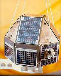
2 Polar satellites 800 km. 99 relative to the Equator S-N during ascending leg & N-S during descending leg Each orbit 100 minutes 14 orbits a day. Sun-Synchronous provides consistent lighting of Earth-scan view. satellite passes the equator and each latitude at same time each day. keep pace with the Earth's revolution around sun Geostationary satellites 35,800 kms speed that matches Earth's rotation same position relative to Earth & views same area covering large areas of Earth useful for monitoring impending weather systems Track movement of storms over long distances. position at Equator, no coverage of polar regions


3 Satellites Sep,22 Jun,21 Dec, 22 Mar, 22 Prograde Retrograde


4 Satellites
 2 a a = semimajor axis b =")


5 Orbital parameters 2 b e = sqrt( 1 ) 2 a a = semimajor axis b = Semi min or axis Perigee, periapsis or perifocus P A Line of Apsides - line betwn AC&PC a= ½ (pericenter distance + apocenter distance ) C b


6 Laws of satellite motion Law of Orbits: All satellites move in elliptical orbits, with the earth at one focus. Law of Areas: A line that connects a satellite to earth sweeps out equal areas in equal times. Law of Periods: square of the period of any planet is proportional to cube of semimajor axis of its orbit

 IRS P6 (RESOURCESAT 1) BHASKARA RS-D1 IRS P8")
7 IMAGING IMPROVEMENTS GLOBAL COVERAGE 1KM TO 0.46 M RESOLUTION APPLICATION-SPECIFIC IRS 1A&1B IRS SERIES (RESOURCESAT 2) IRS P2 IRS 1C IRS 1D IRS P3 IRS P4 OCEANSAT-1 IRS P5 (CARTOSAT) IRS P6 (RESOURCESAT 1) BHASKARA RS-D1 IRS P8 (CARTOSAT-2A) IRS P7 (CARTOSAT-2)


8 Aryabhatt Rohini Stretched Rohini Satellite Series

")
")
9 IRS-1A/B IRS-P3 IRS-P4 TES(2001) Defense sat(1m R)


10 IRS-1C IRS-1D


11 Resourcesat-1 (P6) Cartosat-1 (P5) (P7)


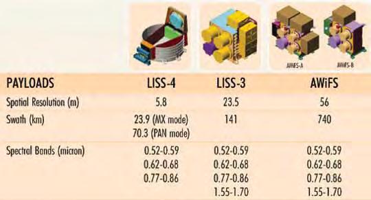
12 LISS IV AWiFs Resolution Spectral: no & width of bands measured by sensor Radiometric: sensitivity of sensor to detect differences in signal strength Spatial: ability of sensor to distinguish small objects; defines PIXEL size` Temporal: frequency of revisit time


![[METSAT]](/docs-images/82/84782718/images/13-3.jpg)

13 INSAT 3B INSAT 3C INSAT 2E INSAT 2C KALPANA - 1 [METSAT]
14

15 SPOT Satellite Launch Date Notes SPOT 1 22 February 1986 Not used SPOT 2 22 January 1990 Operational SPOT 3 26 September 1993 Failed November 1996 SPOT 4 24 March 1998 Operational SPOT 5 4 May 2002 Operational Mode Band Spectral band Resolution XS-multispectral XS µm 20m x 20m XS µm 20m x 20m XS µm 20m x 20m P-panchromatic PAN µm 10m x 10m


16 Japanese Earth Resources Satellite (JERS) Frequency Swath Incidence Angle Resolution 1.3 GHZ L-band 75 km 35 degrees 18 m
17 IRS series (50 sats) IRS-1A/1B/P2 (L-II) LISS-I and LISS-II IRS-1C/1D PAN, LISS-III and WiFS IRS-P3 MOS and WiFS IRS-P4 OCM and MSMR IRS P5 (Carto 1) IRS-P6(RS 1) IRS P7(carto 2) IRS P8 (Carto 2A) Resourcesat 2 SATELLITE MISSIONS Landsat series MSS(archived) and TM NOAA series AVHRR & TOVS (TIROS Operational Vertical Sounder ERS-1 & 2 SAR SPOT MLA/PLA(archived) RADARSAT (Only data distribution)
18 IRS-1A/1B sensors LISS-I Operates in 4 bands in the visible &NIR regions Resolution 72.5 m Swath 148 km LISS-II Operates in same 4 bands as LISS-I Resolution m Swath 74 km
19 IRS-1A/1B Missions first operational indigenous remote sensing satellites IRS-1A was launched in 1988 and provided data upto 1992 IRS-1B launched in 1991 and continues to provide good quality data till date Two sensors (LISS-I & LISS-II)
20 IRS-1C/1D Mission..best in the world IRS-1C was launched in Dec 1995 and IRS-1D in Sep 1997 Three sensors (PAN, LISS-III & WiFS) On-board tape recorder (OBTR) Tilt facility of PAN camera gives stereo viewing capability & revisit of 5 days Large swath of WiFS gives 5 days repetitive coverage
 Resolution 23.")
21 IRS-1C Mission... LISS-III Sensors PAN Operates in one visible band High resolution- 5.8 m Swath - 70 km at nadir 90 km off nadir Tilt capability ± 26 Degrees Operates in 4 bands (3 in visible and NIR & 1 in SWIR) Resolution 23.5 m Swath km WiFS Operates in 2 bands in visible and near infrared Resolution 188 m Swath 810 km
22 IRS-1C COVERAGE WiFS SCENE PATH 810 Km 148 Km(SWIR) ROW 70 Km LISS III SCENE 141 Km PAN SCENE
23 IRS-P3 IRS-P3 is a experimental payload launched during Mar,1996 by PSLV-D3 rocket. It has one X-ray astronomy payload and two remote sensing payloads namely Wide Field sensor (WiFS) Modular Opto-electronics Scanner(MOS)
24 IRS-P3 (out of service 2004) Sensors WiFS MOS-A MOS-B MOS-C Resolution 188 m 1569x x x644 No. of bands Spectral Swath 770 km 195 km 200 km 192 km Repetivity 24 (5) days 24 days 24 days 24 days
25 IRS-P4 SENSORS - Ocean Colour Monitor (OCM) 8 Spectral Bands , , , , , , , m x 236 m spatial resolution high radiometric sensitivity large dynamic range 12 bit radiometric resolution swath 1420 km FOV = +/- 43 deg.
26 IRS-P4 SENSORS - Multi-frequency Scanning Microwave Radiometer(MSMR) Four frequencies 6.6, 10.65, 18.7 and 21.3 GHz Polarisation V and H Spatial Resolution Swath 120, 80, 40 and 40 meters 1420 kms
27 IRS-P4 OCM Applications Development of algorithms for retrieval of ocean and atmospheric parameters. - identification of potential fishing zones in coastal waters. - exploration of deep sea fishery resources. - primary production model and fish stock assessment. - selection and monitoring of algal blooms, Chlorophyll concentration Coastal processes - sediment dynamics - dynamics of estuarine/tidal inlets. - circulation and dispersal pattern. - Upwelling; coastal/oceanic fronts and surface currents. - marine pollution and oil slicks. - coral reef studies.
28 IRS-P4 MSMR Characteristics &Applications geophysical parameters SST, Wind speed, precipitable water in atmosphere, influence black body radiation. passive microwave radiometers. All weather capability Large swath High resolution

29 IRS-P4 IMAGE - OCM The first day image over South India. IMAGE FILE

30 IRS-1C/1D IMAGE - WiFS IRS-1C/1D WiFS image over South India. swath km and 180m resolution IMAGE FILE

31 IRS-1C/1D IMAGE - LISS-III IRS-1C/1D LISS-III picture of Srisailam reservoir, A.P.,India with 23.5 m resolution. IMAGE FILE


32 IRS-1C/1D IMAGE - PAN This image shows part of Hyderabad city, A.P., India with 5.8 m resolution IMAGE FILE PAN high resolution image. Here you can see an Aircraft that is flying. This image was captured South of Frankfurt, Germany

33 IRS-1C/1D IMAGE -PAN This image shows the part of Delhi, India. IMAGE FILE
34 IRS-P5 (Cartosat) 5 May,05 specifications 618 km altitude Sun synchronous with local mean time = hrs ground track variations within 1 km two Pan cameras semi major axis km, i= Total cycle period of 116 days path to path distance 23.4 km Better than 2.5 m resolution Swath 27.5 km for stereo and 55 km for monoscopic mode. 8 km overlap between adjacent paths 10 bits Facility for across track tilt to give better revisit
35 IRS-P5 PAN products and applications Updation of topographic maps Utilities planning Terrain visualisation Generation of topographic databases
36 IRS-P6 Resoursat Sensors LISS-IV 3 bands Spatial resolution of 5.8 m 25 km swath tiltable camera for 5 day revisit LISS-III Spatial resolution of 23 m 141 km swath 24 days repetivity AWiFS 3 bands Spatial resolution of 80 m 1400 km swath Name Waveleng th Res SW Band 1 MS Band 2 MS Band 3 MS Band 1 MS Band 2 MS Band 3 MS Band 4 MS Band 1 MS Band 2 MS Band 3 MS
100 Equatorial crossing (descending node)10:30am Orbit cycle (1 day)- Resolution-")

37 World View 2 Polar Sun Synchronous- 770km Orbit inclination ( ) 97.2 Period of revolution (min)100 Equatorial crossing (descending node)10:30am Orbit cycle (1 day)- Resolution- 46 cm nadir/52 cm off nadir 1.8m MS PAN-50cm Chandrayan-1 31 Dec 2008 Panchro km Red Blue Green Near-IR Red edge Coastal Yellow Near-IR
 1.")
 1 13 PAN 0.45-0.")
 0.52-0.60 (green) 0.63-0.69 (red) 0.")
38 IKONOS - Image Altitude Equator Crossing Repeat Coverage 681km 10:30 a.m. 2.9 days (PAN) 1.5 days (MS) Resolution (m) Swath (km) Sensor Channels Spectral Bands (µm) 1 13 PAN IKONOS1 IKONOS2 IKONOS3 IKONOS (blue) (green) (red) (near IR)

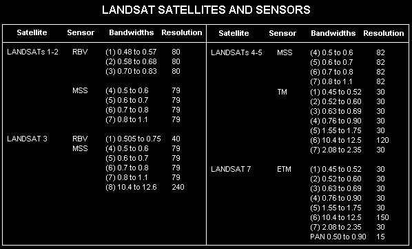
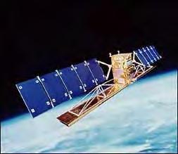
39 Satellite Launch Date Notes Landsat Landsat 1 23 July 1972 Decommissioned 6 January 1978 Landsat 2 22 January 1975 Decommissioned 25 February 1982 Orbview 4 R-1m T-3 days Swath-5-8 km Landsat 3 5 March 1978 Decommissioned 31 March 1983 Landsat 4 16 July 1982 Decommissioned June 2001 Landsat 5 1 March 1984 Operational - Landsat 6 October 1993 Failed on launch Landsat Landsat 7 15 April 1999 Operational -185 km swath MODIS (Mod Res. Imaging Spectroradiometer) 36 bands Resolution- (1-2 bands)-250m (3-7bands)-500m (8-36bands)-1000m 1 day Swath-2200 km ASTER (Adv. Spaceborne Thermal Emission & Reflec. Radiometer) Resolution m 14 bands Swath-60km
40 Landsat

41 RADARSAT SAR Beam Modes

42 RADARSAT Beam Modes & Resolutions 5-24 days revisit launch_ & 2007 ScanSAR Wide 500 x 500 km, 100m resolution Wide 150 X 150 km, 30m resolution Standard 100 x 100 km, 25m resolution Fine 50 x 50 km, 8m resolution
43 RADARSAT Products Beam Mode Fine Standard Wide ScanSAR-N ScanSAR-W Extended Signal Data Single Look Complex Path Image Path Image Plus Map Image Precision Map Image Not Available Not Available Not Available Not Available Not Available Not Available Not Available Not Available
44 European Remote Sensing satellite (ERS)-1 Satellite details : Near polar, sun synchronous orbit Altitude 785 km Equator crossing time am Sensors : AMI, SAR(Image), SAR(Wave), Wind Scatterometer, Radar Altimeter, Along the Track Scanning Radiometer, Microwave Sounder, Laser Retroreflector Spatial resolution for SAR (Image): 25m Swath : 100 km

45 LOCATION OF ARCHIVED STEREOPAIRS URI Gandhi Nagar Goa Pune Shimla DehraDun Chamoli Delhi Lucknow Gwalior Bhopal Nizamabad Hyderabad Tumkur Cuttack Gangtok Mysore Kottayam Nilagiris Coimbatore
46 Classification of Satellite Data Medium High Very High Resolution Resolution Resolution 100 to 20 m 20 to 5 m Less than 5m Optical Multi Band TM, LISS-III LISS-II, MSS LISS-I, AWiFS SPOT MLA IKONOS LISS-IV Optical Single Band SPOT PLA IKONOS 1C/1D PAN P5 PAN Microwave ERS-1/2 Radarsat 1 Radarsat2 Fine beam Fine /Ultra * Stereo Capability

47 Delhi and its surroundings through IRS-P4 OCM IRS-P4 OCM 8 Spectral Bands (nanometers) , , , , , , , m x 236 m spatial resolution High radiometric sensitivity Large dynamic range 12 bit radiometric resolution Swath 1420 km Along track steering to avoid sun glint ± 20 deg. Repetivity of 2 days

48 Delhi & its surroundings through IRS-1D WiFS IRS-1C/1D WiFS Operates in 2 bands in visible & NIR Resolution 188 m Swath 810 km Repetivity of 5 days
 Resolution - 72 m Swath - 148 km Repetivity of")
 Resolution - 36 m Swath - 74 km Repetivity of 22")
49 Delhi through IRS-1B LISS-I IRS-1A/1B LISS-I 4 bands (1 visible & 3 in visible) Resolution - 72 m Swath km Repetivity of 22 days IRS-1A/1B LISS-II Operates in 4 bands (1 visible and 3 in visible) Resolution - 36 m Swath - 74 km Repetivity of 22 days

50 Part of Delhi through IRS-1D LISS-II
 Resolution - 23 m Swath - 141 km Repetivity of 24")
51 Part of Delhi through IRS-1D LISS-III IRS-1C /1DLISS-III Operates in 4 bands (3 in visible and NIR & 1 band in short wave infrared) Resolution - 23 m Swath km Repetivity of 24 days

52 Part of Delhi through IRS-1D PAN IRS-1C /1D PAN 1 band Resolution m Swath - 70 km Repetivity of 5 days Camera tiltable to ±26 deg

53 Part of Pune

54 Part of Delhi through IRS-1D LISS-III + PAN

55 Part of Delhi through IKONOS Panchromatic (single band - black and white) images with a spatial resolution of 1 m and Multispectral images in four spectral bands with 4 m spatial resolution. four bands are: Blue : mm; Green : mm ; Red : mm & NIR: mm. 11 bit

56 Part of Delhi through IKONOS
57 Thank You
9/12/2011. Training Course Remote Sensing Basic Theory & Image Processing Methods September 2011
 Training Course Remote Sensing Basic Theory & Image Processing Methods 19 23 September 2011 Popular Remote Sensing Sensors & their Selection Michiel Damen (September 2011) damen@itc.nl 1 Overview Low resolution
NON-PHOTOGRAPHIC SYSTEMS: Multispectral Scanners Medium and coarse resolution sensor comparisons: Landsat, SPOT, AVHRR and MODIS
 NON-PHOTOGRAPHIC SYSTEMS: Multispectral Scanners Medium and coarse resolution sensor comparisons: Landsat, SPOT, AVHRR and MODIS CLASSIFICATION OF NONPHOTOGRAPHIC REMOTE SENSORS PASSIVE ACTIVE DIGITAL
Indian Remote Sensing Satellites
 Resourcesat-1 Indian Remote Sensing Satellites -Current & Future Resourcesat Missions - Presented by: Timothy J. Puckorius Chairman & CEO EOTec 1 Presentation Topics India s Earth Observation Heritage
EO Sensors : ISRO Past, Current & Future
 EO Sensors : ISRO Past, Current & Future Vinay K Dadhwal Director National Remote Sensing Centre, ISRO, Hyderabad, INDIA International Regional Science Meeting on Land Cover and Land Use Change Dynamics
Lecture 6: Multispectral Earth Resource Satellites. The University at Albany Fall 2018 Geography and Planning
 Lecture 6: Multispectral Earth Resource Satellites The University at Albany Fall 2018 Geography and Planning Outline SPOT program and other moderate resolution systems High resolution satellite systems
Indian Remote Sensing Satellites
 Resourcesat-1 Cartosat-1 Indian Remote Sensing Satellites -Current & Future Missions - Presented by: Timothy J. Puckorius Chairman & CEO EOTec 1 Presentation Topics Who is EOTec India s Earth Observation
Aral Sea profile Selection of area 24 February April May 1998
 250 km Aral Sea profile 1960 1960 1985 1986 1987 1988 1989 1990 1991 1992 1993 1994 1995 1996 1997 1998 2010? Selection of area Area of interest Kzyl-Orda Dried seabed 185 km Syrdarya river Aral Sea Salt
The studies began when the Tiros satellites (1960) provided man s first synoptic view of the Earth s weather systems.
 provided man s first synoptic view of the Earth s weather systems.") Remote sensing of the Earth from orbital altitudes was recognized in the mid-1960 s as a potential technique for obtaining information important for the effective use and conservation of natural resources.
Remote sensing of the Earth from orbital altitudes was recognized in the mid-1960 s as a potential technique for obtaining information important for the effective use and conservation of natural resources.
Remote Sensing Platforms
 Types of Platforms Lighter-than-air Remote Sensing Platforms Free floating balloons Restricted by atmospheric conditions Used to acquire meteorological/atmospheric data Blimps/dirigibles Major role - news
SATELLITE OCEANOGRAPHY
 SATELLITE OCEANOGRAPHY An Introduction for Oceanographers and Remote-sensing Scientists I. S. Robinson Lecturer in Physical Oceanography Department of Oceanography University of Southampton JOHN WILEY
Platforms, Sensors & Data Products
 Platforms, Sensors & Data Products Introduction Remote sensing is defined as the science which deals with obtaining information about objects on earth surface by analysis of data, received from a remote
Some Basic Concepts of Remote Sensing. Lecture 2 August 31, 2005
 Some Basic Concepts of Remote Sensing Lecture 2 August 31, 2005 What is remote sensing Remote Sensing: remote sensing is science of acquiring, processing, and interpreting images and related data that
ROLE OF SATELLITE DATA APPLICATION IN CADASTRAL MAP AND DIGITIZATION OF LAND RECORDS DR.T. RAVISANKAR GROUP HEAD (LRUMG) RSAA/NRSC/ISRO /DOS HYDERABAD
 RSAA/NRSC/ISRO /DOS HYDERABAD") ROLE OF SATELLITE DATA APPLICATION IN CADASTRAL MAP AND DIGITIZATION OF LAND RECORDS DR.T. RAVISANKAR GROUP HEAD (LRUMG) RSAA/NRSC/ISRO /DOS HYDERABAD WORKSHOP on Best Practices under National Land Records
ROLE OF SATELLITE DATA APPLICATION IN CADASTRAL MAP AND DIGITIZATION OF LAND RECORDS DR.T. RAVISANKAR GROUP HEAD (LRUMG) RSAA/NRSC/ISRO /DOS HYDERABAD WORKSHOP on Best Practices under National Land Records
Coral Reef Remote Sensing
 Coral Reef Remote Sensing Spectral, Spatial, Temporal Scaling Phillip Dustan Sensor Spatial Resolutio n Number of Bands Useful Bands coverage cycle Operation Landsat 80m 2 2 18 1972-97 Thematic 30m 7
ISRO s EARTH OBSERVATION SYSTEM (updates from last Plenary) AS Kiran Kumar ISRO, INDIA
 AS Kiran Kumar ISRO, INDIA") ISRO s EARTH OBSERVATION SYSTEM (updates from last Plenary) AS Kiran Kumar ISRO, INDIA The 24 th CEOS Plenary Rio de Janeiro, Brazil 12-15 October, 2010 1 Four Decades of Indian Space Programme 30LV Missions
ISRO s EARTH OBSERVATION SYSTEM (updates from last Plenary) AS Kiran Kumar ISRO, INDIA The 24 th CEOS Plenary Rio de Janeiro, Brazil 12-15 October, 2010 1 Four Decades of Indian Space Programme 30LV Missions
Final Examination Introduction to Remote Sensing. Time: 1.5 hrs Max. Marks: 50. Section-I (50 x 1 = 50 Marks)
") Final Examination Introduction to Remote Sensing Time: 1.5 hrs Max. Marks: 50 Note: Attempt all questions. Section-I (50 x 1 = 50 Marks) 1... is the technology of acquiring information about the Earth's
Final Examination Introduction to Remote Sensing Time: 1.5 hrs Max. Marks: 50 Note: Attempt all questions. Section-I (50 x 1 = 50 Marks) 1... is the technology of acquiring information about the Earth's
CHAPTER 7: Multispectral Remote Sensing
 CHAPTER 7: Multispectral Remote Sensing REFERENCE: Remote Sensing of the Environment John R. Jensen (2007) Second Edition Pearson Prentice Hall Overview of How Digital Remotely Sensed Data are Transformed
An Introduction to Geomatics. Prepared by: Dr. Maher A. El-Hallaq خاص بطلبة مساق مقدمة في علم. Associate Professor of Surveying IUG
 An Introduction to Geomatics خاص بطلبة مساق مقدمة في علم الجيوماتكس Prepared by: Dr. Maher A. El-Hallaq Associate Professor of Surveying IUG 1 Airborne Imagery Dr. Maher A. El-Hallaq Associate Professor
Microwave Remote Sensing (1)
") Microwave Remote Sensing (1) Microwave sensing encompasses both active and passive forms of remote sensing. The microwave portion of the spectrum covers the range from approximately 1cm to 1m in wavelength.
Microwave Remote Sensing (1) Microwave sensing encompasses both active and passive forms of remote sensing. The microwave portion of the spectrum covers the range from approximately 1cm to 1m in wavelength.
(updates from last Plenary) AS Kiran Kumar ISRO, INDIA
 AS Kiran Kumar ISRO, INDIA") ISRO s EARTH OBSERVATION SYSTEM (updates from last Plenary) AS Kiran Kumar ISRO, INDIA The 24 th CEOS Plenary Rio de Janeiro, Brazil 12 15 October, 2010 1 Four Decades of Indian Space Programme 30 LV Missions
ISRO s EARTH OBSERVATION SYSTEM (updates from last Plenary) AS Kiran Kumar ISRO, INDIA The 24 th CEOS Plenary Rio de Janeiro, Brazil 12 15 October, 2010 1 Four Decades of Indian Space Programme 30 LV Missions
BASICS OF REMOTE SENSING
 BASICS OF REMOTE SENSING 23: Basics of Remote Sensing Shibendu Shankar Ray Mahalanobis National Crop Forecast Centre, Department of Agriculture & Cooperation, Krishi Vistar Sadan, Pusa Campus, New Delhi
3/31/03. ESM 266: Introduction 1. Observations from space. Remote Sensing: The Major Source for Large-Scale Environmental Information
 Remote Sensing: The Major Source for Large-Scale Environmental Information Jeff Dozier Observations from space Sun-synchronous polar orbits Global coverage, fixed crossing, repeat sampling Typical altitude
On the use of water color missions for lakes in 2021
 Lakes and Climate: The Role of Remote Sensing June 01-02, 2017 On the use of water color missions for lakes in 2021 Cédric G. Fichot Department of Earth and Environment 1 Overview 1. Past and still-ongoing
The Global Imager (GLI)
") The Global Imager (GLI) Launch : Dec.14, 2002 Initial check out : to Apr.14, 2003 (~L+4) First image: Jan.25, 2003 Second image: Feb.6 and 7, 2003 Calibration and validation : to Dec.14, 2003(~L+4) for
The Global Imager (GLI) Launch : Dec.14, 2002 Initial check out : to Apr.14, 2003 (~L+4) First image: Jan.25, 2003 Second image: Feb.6 and 7, 2003 Calibration and validation : to Dec.14, 2003(~L+4) for
Introduction to Remote Sensing Fundamentals of Satellite Remote Sensing. Mads Olander Rasmussen
 Introduction to Remote Sensing Fundamentals of Satellite Remote Sensing Mads Olander Rasmussen (mora@dhi-gras.com) 01. Introduction to Remote Sensing DHI What is remote sensing? the art, science, and technology
Lecture Notes Prepared by Prof. J. Francis Spring Remote Sensing Instruments
 Lecture Notes Prepared by Prof. J. Francis Spring 2005 Remote Sensing Instruments Material from Remote Sensing Instrumentation in Weather Satellites: Systems, Data, and Environmental Applications by Rao,
REMOTE SENSING FOR FLOOD HAZARD STUDIES.
 REMOTE SENSING FOR FLOOD HAZARD STUDIES. OPTICAL SENSORS. 1 DRS. NANETTE C. KINGMA 1 Optical Remote Sensing for flood hazard studies. 2 2 Floods & use of remote sensing. Floods often leaves its imprint
Int n r t o r d o u d c u ti t on o n to t o Remote Sensing
 Introduction to Remote Sensing Definition of Remote Sensing Remote sensing refers to the activities of recording/observing/perceiving(sensing)objects or events at far away (remote) places. In remote sensing,
Light penetration within a clear water body. E z = E 0 e -kz
 THE BLUE PLANET 1 2 Light penetration within a clear water body E z = E 0 e -kz 3 4 5 Pure Seawater Phytoplankton b w 10-2 m -1 b w 10-2 m -1 b w, Morel (1974) a w, Pope and Fry (1997) b chl,loisel and
An Introduction to Remote Sensing & GIS. Introduction
 An Introduction to Remote Sensing & GIS Introduction Remote sensing is the measurement of object properties on Earth s surface using data acquired from aircraft and satellites. It attempts to measure something
Remote Sensing in Daily Life. What Is Remote Sensing?
 Remote Sensing in Daily Life What Is Remote Sensing? First time term Remote Sensing was used by Ms Evelyn L Pruitt, a geographer of US in mid 1950s. Minimal definition (not very useful): remote sensing
9/12/2011. Training Course Remote Sensing Basic Theory & Image Processing Methods September 2011
 Training Course Remote Sensing Basic Theory & Image Processing Methods 19 23 September 2011 Remote Sensing Platforms Michiel Damen (September 2011) damen@itc.nl 1 Overview Platforms & missions aerial surveys
The studies began when the Tiros satellites (1960) provided man s first synoptic view of the Earth s weather systems.
 provided man s first synoptic view of the Earth s weather systems.") Remote sensing of the Earth from orbital altitudes was recognized in the mid-1960 s as a potential technique for obtaining information important for the effective use and conservation of natural resources.
Remote sensing of the Earth from orbital altitudes was recognized in the mid-1960 s as a potential technique for obtaining information important for the effective use and conservation of natural resources.
Copernicus Introduction Lisbon, Portugal 13 th & 14 th February 2014
 Copernicus Introduction Lisbon, Portugal 13 th & 14 th February 2014 Contents Introduction GMES Copernicus Six thematic areas Infrastructure Space data An introduction to Remote Sensing In-situ data Applications
Earth s Gravitational Pull
 Satellite & Sensors Space Countries Earth s Gravitational Pull The Earth's gravity pulls everything toward the Earth. In order to orbit the Earth, the velocity of a body must be great enough to overcome
Remote Sensing Platforms
 Remote Sensing Platforms Remote Sensing Platforms - Introduction Allow observer and/or sensor to be above the target/phenomena of interest Two primary categories Aircraft Spacecraft Each type offers different
Introduction to Remote Sensing
 Introduction to Remote Sensing Spatial, spectral, temporal resolutions Image display alternatives Vegetation Indices Image classifications Image change detections Accuracy assessment Satellites & Air-Photos
EO Data Today and Application Fields. Denise Petala
 EO Data Today and Application Fields Denise Petala ! IGD GROUP AE "Infotop SA, Geomet Ltd., Dynatools Ltd. "Equipment and know how in many application fields, from surveying till EO data and RS. # Leica,
Sources of Geographic Information
 Sources of Geographic Information Data properties: Spatial data, i.e. data that are associated with geographic locations Data format: digital (analog data for traditional paper maps) Data Inputs: sampled
remote sensing? What are the remote sensing principles behind these Definition
 Introduction to remote sensing: Content (1/2) Definition: photogrammetry and remote sensing (PRS) Radiation sources: solar radiation (passive optical RS) earth emission (passive microwave or thermal infrared
EXAMPLES OF TOPOGRAPHIC MAPS PRODUCED FROM SPACE AND ACHIEVED ACCURACY CARAVAN Workshop on Mapping from Space, Phnom Penh, June 2000
 EXAMPLES OF TOPOGRAPHIC MAPS PRODUCED FROM SPACE AND ACHIEVED ACCURACY CARAVAN Workshop on Mapping from Space, Phnom Penh, June 2000 Jacobsen, Karsten University of Hannover Email: karsten@ipi.uni-hannover.de
Outline. Introduction. Introduction: Film Emulsions. Sensor Systems. Types of Remote Sensing. A/Prof Linlin Ge. Photographic systems (cf(
 GMAT x600 Remote Sensing / Earth Observation Types of Sensor Systems (1) Outline Image Sensor Systems (i) Line Scanning Sensor Systems (passive) (ii) Array Sensor Systems (passive) (iii) Antenna Radar
Geospatial Vision and Policies Korean Industry View 26 November, 2014 SI Imaging Services
 Geospatial Vision and Policies Korean Industry View 26 November, 2014 SI Imaging Services Distribution Limitation, SI Imaging Services Proprietary Data : The data contained in this document, without the
Geoinformatics. S S Jadhav Department of Geography M J College, Jalgaon Mail: Cell:
 Geoinformatics S S Jadhav Department of Geography M J College, Jalgaon Mail: sahadeoj@gmail.com Cell: 9763267396 1 Satellite Remote Sensing: What is Remote Sensing? "Remote sensing is the science (and
746A27 Remote Sensing and GIS. Multi spectral, thermal and hyper spectral sensing and usage
 746A27 Remote Sensing and GIS Lecture 3 Multi spectral, thermal and hyper spectral sensing and usage Chandan Roy Guest Lecturer Department of Computer and Information Science Linköping University Multi
Remote Sensing 1 Principles of visible and radar remote sensing & sensors
 Remote Sensing 1 Principles of visible and radar remote sensing & sensors Nick Barrand School of Geography, Earth & Environmental Sciences University of Birmingham, UK Field glaciologist collecting data
Fundamentals of Remote Sensing
 Climate Variability, Hydrology, and Flooding Fundamentals of Remote Sensing May 19-22, 2015 GEO-Latin American & Caribbean Water Cycle Capacity Building Workshop Cartagena, Colombia 1 Objective To provide
CHAPTER --'3 DATA DESCRIPTION
 CHAPTER --'3 DATA DESCRIPTION 37 3.1 INTRODUCTION In chapter 2 different techniques used for the study of polar cryosphere like passive and active remote sensing, altimetry and scatterometry are described.
High Resolution Sensor Test Comparison with SPOT, KFA1000, KVR1000, IRS-1C and DPA in Lower Saxony
 High Resolution Sensor Test Comparison with SPOT, KFA1000, KVR1000, IRS-1C and DPA in Lower Saxony K. Jacobsen, G. Konecny, H. Wegmann Abstract The Institute for Photogrammetry and Engineering Surveys
Satellite Imagery and Remote Sensing. DeeDee Whitaker SW Guilford High EES & Chemistry
 Satellite Imagery and Remote Sensing DeeDee Whitaker SW Guilford High EES & Chemistry whitakd@gcsnc.com Outline What is remote sensing? How does remote sensing work? What role does the electromagnetic
Important Missions. weather forecasting and monitoring communication navigation military earth resource observation LANDSAT SEASAT SPOT IRS
 Fundamentals of Remote Sensing Pranjit Kr. Sarma, Ph.D. Assistant Professor Department of Geography Mangaldai College Email: prangis@gmail.com Ph. No +91 94357 04398 Remote Sensing Remote sensing is defined
John P. Stevens HS: Remote Sensing Test
 Name(s): Date: Team name: John P. Stevens HS: Remote Sensing Test 1 Scoring: Part I - /18 Part II - /40 Part III - /16 Part IV - /14 Part V - /93 Total: /181 2 I. History (3 pts. each) 1. What is the name
Microwave Remote Sensing
 Provide copy on a CD of the UCAR multi-media tutorial to all in class. Assign Ch-7 and Ch-9 (for two weeks) as reading material for this class. HW#4 (Due in two weeks) Problems 1,2,3 and 4 (Chapter 7)
Spectral Signatures. Vegetation. 40 Soil. Water WAVELENGTH (microns)
") Spectral Signatures % REFLECTANCE VISIBLE NEAR INFRARED Vegetation Soil Water.5. WAVELENGTH (microns). Spectral Reflectance of Urban Materials 5 Parking Lot 5 (5=5%) Reflectance 5 5 5 5 5 Wavelength (nm)
Spectral Signatures % REFLECTANCE VISIBLE NEAR INFRARED Vegetation Soil Water.5. WAVELENGTH (microns). Spectral Reflectance of Urban Materials 5 Parking Lot 5 (5=5%) Reflectance 5 5 5 5 5 Wavelength (nm)
IKONOS High Resolution Multispectral Scanner Sensor Characteristics
 High Spatial Resolution and Hyperspectral Scanners IKONOS High Resolution Multispectral Scanner Sensor Characteristics Launch Date View Angle Orbit 24 September 1999 Vandenberg Air Force Base, California,
KOMPSAT Constellation. November 2012 Satrec Initiative
 KOMPSAT Constellation November 2012 Satrec Initiative KOMPSAT Constellation KOMPSAT National program Developed and operated by KARI (Korea Aerospace Research Institute) Dual use : Government & commercial
Introduction to Remote Sensing
 Introduction to Remote Sensing Daniel McInerney Urban Institute Ireland, University College Dublin, Richview Campus, Clonskeagh Drive, Dublin 14. 16th June 2009 Presentation Outline 1 2 Spaceborne Sensors
Introduction of Satellite Remote Sensing
 Introduction of Satellite Remote Sensing Spatial Resolution (Pixel size) Spectral Resolution (Bands) Resolutions of Remote Sensing 1. Spatial (what area and how detailed) 2. Spectral (what colors bands)
Remote Sensing Exam 2 Study Guide
 Remote Sensing Exam 2 Study Guide Resolution Analog to digital Instantaneous field of view (IFOV) f ( cone angle of optical system ) Everything in that area contributes to spectral response mixels Sampling
Remote Sensing. Ch. 3 Microwaves (Part 1 of 2)
") Remote Sensing Ch. 3 Microwaves (Part 1 of 2) 3.1 Introduction 3.2 Radar Basics 3.3 Viewing Geometry and Spatial Resolution 3.4 Radar Image Distortions 3.1 Introduction Microwave (1cm to 1m in wavelength)
Remote Sensing Ch. 3 Microwaves (Part 1 of 2) 3.1 Introduction 3.2 Radar Basics 3.3 Viewing Geometry and Spatial Resolution 3.4 Radar Image Distortions 3.1 Introduction Microwave (1cm to 1m in wavelength)
Introduction to KOMPSAT
 Introduction to KOMPSAT September, 2016 1 CONTENTS 01 Introduction of SIIS 02 KOMPSAT Constellation 03 New : KOMPSAT-3 50 cm 04 New : KOMPSAT-3A 2 KOMPSAT Constellation KOMPSAT series National space program
AR M. Sc. (Rural Technology) II Semester Fundamental of Remote Sensing Model Paper
 II Semester Fundamental of Remote Sensing Model Paper") 1. Multiple choice question ; AR- 7251 M. Sc. (Rural Technology) II Semester Fundamental of Remote Sensing Model Paper 1. Chlorophyll strongly absorbs radition of : (b) Red and Blue wavelength (ii) Which
1. Multiple choice question ; AR- 7251 M. Sc. (Rural Technology) II Semester Fundamental of Remote Sensing Model Paper 1. Chlorophyll strongly absorbs radition of : (b) Red and Blue wavelength (ii) Which
(Refer Slide Time: 1:20)
") Introduction to Remote Sensing Dr. Arun K Saraf Department of Earth Sciences Indian Institute of Technology Roorkee Lecture 02 Development of Remote Sensing Technology & Advantages Hello! This is second
Introduction to Remote Sensing Dr. Arun K Saraf Department of Earth Sciences Indian Institute of Technology Roorkee Lecture 02 Development of Remote Sensing Technology & Advantages Hello! This is second
9/12/2011. Training Course Remote Sensing Basic Theory & Image Processing Methods September 2011
 Training Course Remote Sensing Basic Theory & Image Processing Methods 19 23 September 2011 Introduction to Remote Sensing Michiel Damen (September 2011) damen@itc.nl 1 Overview Some definitions Remote
Introduction to Remote Sensing
 Introduction to Remote Sensing Outline Remote Sensing Defined Resolution Electromagnetic Energy (EMR) Types Interpretation Applications Remote Sensing Defined Remote Sensing is: The art and science of
746A27 Remote Sensing and GIS
 746A27 Remote Sensing and GIS Lecture 1 Concepts of remote sensing and Basic principle of Photogrammetry Chandan Roy Guest Lecturer Department of Computer and Information Science Linköping University What
Chapter 3. Data Acquisition Systems. Ayman F. Habib. Remote Sensing
 Chapter 3 Data Acquisition Systems 1 Overview Utilized portions of the electro-magnetic radiation. Visible band. Infrared band. LIDAR systems. Microwave band (RADAR). Optical sensors (scanning operational
Remote Sensing for Resource Management
 Remote Sensing for Resource Management Ebenezer Nyadjro US Naval Research Lab/UNO RMU Summer Program (July 31-AUG 4, 2017) Motivation Polluted Pra River Motivation. 3 Motivation Polluted Pra River Motivation.
GIS Data Collection. Remote Sensing
 GIS Data Collection Remote Sensing Data Collection Remote sensing Introduction Concepts Spectral signatures Resolutions: spectral, spatial, temporal Digital image processing (classification) Other systems
(Refer Slide Time: 1:28)
") Introduction to Remote Sensing Dr. Arun K Saraf Department of Earth Sciences Indian Institute of Technology Roorkee Lecture 10 Image characteristics and different resolutions in Remote Sensing Hello everyone,
Introduction to Remote Sensing Dr. Arun K Saraf Department of Earth Sciences Indian Institute of Technology Roorkee Lecture 10 Image characteristics and different resolutions in Remote Sensing Hello everyone,
SEA GRASS MAPPING FROM SATELLITE DATA
 JSPS National Coordinators Meeting, Coastal Marine Science 19 20 May 2008 Melaka SEA GRASS MAPPING FROM SATELLITE DATA Mohd Ibrahim Seeni Mohd, Nurul Hazrina Idris, Samsudin Ahmad 1. Introduction PRESENTATION
Blacksburg, VA July 24 th 30 th, 2010 Remote Sensing Page 1. A condensed overview. For our purposes
 A condensed overview George McLeod Prepared by: With support from: NSF DUE-0903270 in partnership with: Geospatial Technician Education Through Virginia s Community Colleges (GTEVCC) The art and science
INF-GEO Introduction to remote sensing
 INF-GEO 4310 Introduction to remote sensing Anne Solberg (anne@ifi.uio.no) Satellites, orbits and repeat cycles Optical remote sensings Based on a tutorial adapted from Canadian Center for Remote Sensing,
XSAT Ground Segment at CRISP
 XSAT Ground Segment at CRISP LIEW Soo Chin Head of Research, CRISP http://www.crisp.nus.edu.sg 5 th JPTM for Sentinel Asia Step-2, 14-16 Nov 2012, Daejeon, Korea Centre for Remote Imaging, Sensing and
Sensor resolutions from space: the tension between temporal, spectral, spatial and swath. David Bruce UniSA and ISU
 Sensor resolutions from space: the tension between temporal, spectral, spatial and swath David Bruce UniSA and ISU 1 Presentation aims 1. Briefly summarize the different types of satellite image resolutions
Passive Microwave Sensors LIDAR Remote Sensing Laser Altimetry. 28 April 2003
 Passive Microwave Sensors LIDAR Remote Sensing Laser Altimetry 28 April 2003 Outline Passive Microwave Radiometry Rayleigh-Jeans approximation Brightness temperature Emissivity and dielectric constant
Satellite Imagery Characteristics, Uses and Delivery to GIS Systems. Wayne Middleton April 2014
 Satellite Imagery Characteristics, Uses and Delivery to GIS Systems Wayne Middleton April 2014 About Geoimage Founded in Brisbane 1988 Leading Independent company Specialists in satellite imagery and geospatial
Remote Sensing. Division C. Written Exam
 Remote Sensing Division C Written Exam Team Name: Team #: Team Members: _ Score: /132 A. Matching (10 points) 1. Nadir 2. Albedo 3. Diffraction 4. Refraction 5. Spatial Resolution 6. Temporal Resolution
JP Stevens High School: Remote Sensing
 1 Name(s): ANSWER KEY Date: Team name: JP Stevens High School: Remote Sensing Scoring: Part I - /18 Part II - /40 Part III - /16 Part IV - /14 Part V - /93 Total: /181 2 I. History (3 pts each) 1. What
Satellite Remote Sensing: Earth System Observations
 Satellite Remote Sensing: Earth System Observations Land surface Water Atmosphere Climate Ecosystems 1 EOS (Earth Observing System) Develop an understanding of the total Earth system, and the effects of
Operational Space-Based Imaging Systems
 Operational Space-Based Imaging Systems R E M O T E S E N S I N G & G E O S PAT I A L A N A LY S I S L A B D O I : 2 0 A U G U S T, 2 0 1 6 Earth Observation Systems U.S. or foreign government systems
Applied GIS & Remote Sensing for Disaster Mitigation #4
 Applied GIS & Remote Sensing for Disaster Mitigation #4 By Koki IWAO Senior Program Specialist iwao@ait.ac.th http://www.acrors.ait.ac.th www.acrors.ait.ac.th/ Asian Center for Research on Remote Sensing
Chapter 8. Remote sensing
 1. Remote sensing 8.1 Introduction 8.2 Remote sensing 8.3 Resolution 8.4 Landsat 8.5 Geostationary satellites GOES 8.1 Introduction What is remote sensing? One can describe remote sensing in different
REMOTE SENSING. Topic 10 Fundamentals of Digital Multispectral Remote Sensing MULTISPECTRAL SCANNERS MULTISPECTRAL SCANNERS
 REMOTE SENSING Topic 10 Fundamentals of Digital Multispectral Remote Sensing Chapter 5: Lillesand and Keifer Chapter 6: Avery and Berlin MULTISPECTRAL SCANNERS Record EMR in a number of discrete portions
Kaukokartoitus ympäristön tilan seurannassa. Remote sensing for environmental monitoring
 Kaukokartoitus ympäristön tilan seurannassa Remote sensing for environmental monitoring Arto Vuorela 1 Contents Traditional applications, governmental activities etc. for environmental monitoring New or
Lecture 13: Remotely Sensed Geospatial Data
 Lecture 13: Remotely Sensed Geospatial Data A. The Electromagnetic Spectrum: The electromagnetic spectrum (Figure 1) indicates the different forms of radiation (or simply stated light) emitted by nature.
CHARACTERISTICS OF VERY HIGH RESOLUTION OPTICAL SATELLITES FOR TOPOGRAPHIC MAPPING
 CHARACTERISTICS OF VERY HIGH RESOLUTION OPTICAL SATELLITES FOR TOPOGRAPHIC MAPPING K. Jacobsen Leibniz University Hannover, Institute of Photogrammetry and Geoinformation jacobsen@ipi.uni-hannover.de Commission
A map says to you, 'Read me carefully, follow me closely, doubt me not.' It says, 'I am the Earth in the palm of your hand. Without me, you are alone
 A map says to you, 'Read me carefully, follow me closely, doubt me not.' It says, 'I am the Earth in the palm of your hand. Without me, you are alone and lost. Beryl Markham (West With the Night, 1946
AVHRR/3 Operational Calibration
 AVHRR/3 Operational Calibration Jörg Ackermann, Remote Sensing and Products Division 1 Workshop`Radiometric Calibration for European Missions, 30/31 Aug. 2017`,Frascati (EUM/RSP/VWG/17/936014) AVHRR/3
US Commercial Imaging Satellites
 US Commercial Imaging Satellites In the early 1990s, Russia began selling 2-meter resolution product from its archives of collected spy satellite imagery. Some of this product was down-sampled to provide
India recently successfully launched its PSLV-C16 rocked that carried into orbit the latest remote
 India recently successfully launched its PSLV-C16 rocked that carried into orbit the latest remote sensing satellite REsourcesat-2 that would study and help manage natural resources along with two Nano
Agency Report: Indian Earth Observation Programme
 Agency Report: Indian Earth Observation Programme Nitant Dube Space Applications Centre Indian Space Research Organisation Presentation to CEOS WGISS-41, Canberra Australia, March 2016 Indian EO Programme:
REMOTE SENSING INTERPRETATION
 REMOTE SENSING INTERPRETATION Jan Clevers Centre for Geo-Information - WU Remote Sensing --> RS Sensor at a distance EARTH OBSERVATION EM energy Earth RS is a tool; one of the sources of information! 1
Dr. P Shanmugam. Associate Professor Department of Ocean Engineering Indian Institute of Technology (IIT) Madras INDIA
 Madras INDIA") Dr. P Shanmugam Associate Professor Department of Ocean Engineering Indian Institute of Technology (IIT) Madras INDIA Biography Ph.D (Remote Sensing and Image Processing for Coastal Studies) - Anna University,
Dr. P Shanmugam Associate Professor Department of Ocean Engineering Indian Institute of Technology (IIT) Madras INDIA Biography Ph.D (Remote Sensing and Image Processing for Coastal Studies) - Anna University,
Current and Future Meteorological Satellite Program of China
 Current and Future Meteorological Satellite Program of China ZHANG Wenjian, DONG Chaohua XU Jianmin, YANG Jun China Meteorological Administration May 30, 2005 Beijing, CHINA Outline of the Presentation
CHARACTERISTICS OF REMOTELY SENSED IMAGERY. Radiometric Resolution
 CHARACTERISTICS OF REMOTELY SENSED IMAGERY Radiometric Resolution There are a number of ways in which images can differ. One set of important differences relate to the various resolutions that images express.
Intersatellite Calibration of infrared sensors onboard Indian Geostationary Satellites using LEO Hyperspectral Observations
 Updates from GSICS members and Observers Indian Space Research Organisation (ISRO) Intersatellite Calibration of infrared sensors onboard Indian Geostationary Satellites using LEO Hyperspectral Observations
1. Theory of remote sensing and spectrum
 1. Theory of remote sensing and spectrum 7 August 2014 ONUMA Takumi Outline of Presentation Electromagnetic wave and wavelength Sensor type Spectrum Spatial resolution Spectral resolution Mineral mapping
Active and Passive Microwave Remote Sensing
 Active and Passive Microwave Remote Sensing Passive remote sensing system record EMR that was reflected (e.g., blue, green, red, and near IR) or emitted (e.g., thermal IR) from the surface of the Earth.
LE/ESSE Payload Design
 LE/ESSE4360 - Payload Design 3.2 Spacecraft Sensors Introduction to Sensors Earth, Moon, Mars, and Beyond Dr. Jinjun Shan, Professor of Space Engineering Department of Earth and Space Science and Engineering