The Sentinel-1 Constellation
|
|
|
- Godwin Dennis
- 5 years ago
- Views:
Transcription

1 The Sentinel-1 Constellation Evert Attema, Sentinel-1 Mission & System Manager AGRISAR and EAGLE Campaigns Final Workshop October 2007 ESA/ESTECNoordwijk, The Netherlands

2 Sentinel-1 Programme Sentinel-1 System Sentinel-1 Information Products
3 Programme Status
")


4 Sentinel-1 Programme Status Component of EU & ESA s Global Monitoring for Environment and Security Programme (GMES) Contract signed for development, launch and commissioning First Satellite launch Q Services provided for 20 years st S1 Dev LC 2nd S1 Dev 3rd S1 Dev LC LC 3rd model launched in case of launcher failure Storage
5 Sentinel-1 Mission Requirements Goal Provide Coverage and Repeat Observation to Completely Cover on a Daily Basis the world s land masses; coastal zones and shipping routes; open ocean. Requirements Sufficient Instrument Resources in terms of Temporal Coverage: Short Orbit Repeat Cycle Spatial Coverage: Wide Swath Operation Time per Orbit Pre-programmed Conflict-free Acquisition Plan Restricted Choice of Mutually-Exclusive Measurement Modes Sufficient Ground Segment Resources in terms of Satellite Control and Orbit Maintenance Data Down-link Capacity Processing, Distribution & Archiving Capacity
6 System Update
7 Sentinel-1 System Sentinel-1 has one main operational mode (Interferometric Wide Swath mode) that: satisfies most currently known service requirements avoids conflicts and preserves revisit performance provides robustness and reliability of service simplifies mission planning & decreases operational costs satisfies also tomorrow s requests by building up a consistent long-term archive However Mutually exclusive modes are provided for continuity reasons (w.r.t. ERS & Envisat) and for accommodation of emerging user requirements Two mutually exclusive dual polarisation modes are provided
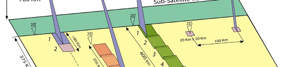
8 Sentinel-1 System Modes Access Angle Resolution (Range x Azimuth) Swath Width Polarisation Strip Map deg. 5 x 5 m, 1 look > 80 km HH+HV, VV+VH Interferometric Wide Swath > 25 deg. 5 x 20 m, 1 look > 250 km HH+HV, VV+VH Extra Wide Swath > 20 deg. 25 x 100 m, 3 looks > 400 km HH+HV, VV+VH Wave mode 23 deg. 5 x 20 m, 1 look > 20 x 20 km Vignettes at 100 km intervals HH, VV For All Modes: Radiometric accuracy (3 σ): 1 db NESZ: -22 db PTAR: -25 db DTAR: -22 db

9 Observation Geometry
10 Space Segment Sentinel-1 System LEO satellite with a nominal lifetime in orbit of 7 years (extendible to 12), ensuring global coverage by flying on a Near-Polar Sun- Synchronous dusk-dawn Low Earth Orbit. A constellation with a second satellite is planned in the same orbit but with a different Mean Anomaly. The satellites embark a C-Band Synthetic Aperture Radar (SAR) payload. Ground Segment Mission operations for a system of satellites over a period of 20 years. Proposed S-Band station is Kiruna, with a back-up for S/C contingencies. The X-Band downlink currently assumes, for preliminary sizing, three X-Band receiving stations.
 Data from Reception to End-Users in less than one")
11 Sentinel-1 Timeliness Near Real Time (inside Ground Station Visibility) Data from Reception to End-Users in less than one hour
 ~ 90 GByte/orbit")

12 Sentinel-1 Timeliness Near Real Time (outside Ground Station Visibility) ~ 90 GByte/orbit Up to ~ 100 minutes travel in orbit Data from Reception to End- Users in less than one hour

13 Sentinel-1 Timeliness Off Line All data processed, archived and ready for use in less than 24 hours from reception


14 Sentinel-1 Revisit Coverage Analysis Coverage with two satellites after days Canada Europe


15 Coverage of Areas of Interest

16 Simplified impossible Mission Scenario
17 Information Products
 Monthly Soil")
18 Information Product (1) Monthly Soil Moisture
 Daily Ice")
19 Information Product (2) Daily Ice Monitoring
 Algorithm based on image intensity differences combined with suitable")

20 Snow Cover Algorithm (SCA) Algorithm developed and validated by NORUT (ESA contract 19629/05/NL/CB ) Algorithm based on image intensity differences combined with suitable thresholds (2000, Nagler & Rott) Analysis of SAR sensitivity was therefore performed on the basis of real data and simulated noise Level-1 Data Black Box Algorithm Thresholds Simulated Noise

![[mm/year]](/docs-images/86/93335612/images/21-1.jpg "Barcelona")

21 Subsidence Estimation [mm/year] Barcelona (Spain) Envisat ASAR 5 images [ ]
Sentinel-1 Calibration and Performance
 Sentinel-1 Calibration and Performance Paul Snoeij Evert Attema Björn Rommen Nicolas Floury Berthyl Duesmann Malcolm Davidson Ramon Torres European Space Agency Sentinel-1 Mission Objectives Component
Sentinel-1 Overview. Dr. Andrea Minchella
 Dr. Andrea Minchella 21-22/01/2016 ESA SNAP-Sentinel-1 Training Course Satellite Applications Catapult - Electron Building, Harwell, Oxfordshire Contents Sentinel-1 Mission Sentinel-1 SAR Modes Sentinel-1
GMES Sentinel-1 Transponder Development
 GMES Sentinel-1 Transponder Development Paul Snoeij Evert Attema Björn Rommen Nicolas Floury Malcolm Davidson ESA/ESTEC, European Space Agency, Noordwijk, The Netherlands Outline 1. GMES Sentinel-1 overview
Sentinel-1 System Overview
 Sentinel-1 System Overview Dirk Geudtner, Rámon Torres, Paul Snoeij, Malcolm Davidson European Space Agency, ESTEC Global Monitoring for Environment and Security (GMES) EU-led program aiming at providing
ERS/ENVISAT ASAR Data Products and Services
 ERS/ENVISAT ASAR Data Products and Services Andrea Celentano Business Manager celentan@eurimage.com What is Eurimage? Founded in 1989 Current shareholders: Since 1989 Commercial Partner of the European
RADARSAT-2 Program Update Daniel De Lisle Canadian Space Agency
 RADARSAT-2 Program Update Daniel De Lisle Canadian Space Agency Presentation outline RADARSAT-1 Update RADARSAT-2 Mission description Mission Objectives System Characteristics Data Commercialization/Allocation
Status of Sentinel-1 and acquisition plans for GFOI
 Status of Sentinel-1 and acquisition plans for GFOI Frank Martin Seifert, Pierre Potin, Johannes Roeder, ESA Earth Observation Programme 5 th Space Data Coordination, ESRIN, Frascati, 24 February 2014
SAR missions for oceanography at the European Space Agency
 SAR missions for oceanography at the European Space Agency ERS-1, ERS-2, Envisat, Sentinel-1A, Sentinel-1B, ESA 3 rd Party Missions (ALOS) Prepared by ESA teams and ESA supporting companies ESA and SAR
Copernicus Introduction Lisbon, Portugal 13 th & 14 th February 2014
 Copernicus Introduction Lisbon, Portugal 13 th & 14 th February 2014 Contents Introduction GMES Copernicus Six thematic areas Infrastructure Space data An introduction to Remote Sensing In-situ data Applications
Towards Sentinel-1 Soil Moisture Data Services: The Approach taken by the Earth Observation Data Centre for Water Resources Monitoring
 Towards Sentinel-1 Soil Moisture Data Services: The Approach taken by the Earth Observation Data Centre for Water Resources Monitoring Wolfgang Wagner wolfgang.wagner@geo.tuwien.ac.at Department of Geodesy
The use of satellite images to forecast agricultural
 The use of satellite images to forecast agricultural Luxembourg, 12.03.2014 r. Tomasz Milewski NUTS for Poland: NUTS 1 macro-regions (grup of province, voivodships) (6), NUTS 2 - regions (province,
ASSESSMENT BY ESA OF GCOS CLIMATE MONITORING PRINCIPLES FOR GMES
 Prepared by ESA Agenda Item: III.5 Discussed in WG3 ASSESSMENT BY ESA OF GCOS CLIMATE MONITORING PRINCIPLES FOR GMES The ESA Sentinel missions are being designed for the GMES services, with special emphasis
Biomass, a polarimetric interferometric P-band SAR mission
 Biomass, a polarimetric interferometric P-band SAR mission M. Arcioni, P. Bensi, M. Fehringer, F. Fois, F. Heliere, N. Miranda, K. Scipal Fringe 2015, ESRIN 27/03/2015 The Biomass Mission 1. Biomass was
The Current Status and Brief Results of Engineering Model for PALSAR-2 onboard ALOS-2 and Science Project
 The Current Status and Brief Results of Engineering Model for PALSAR-2 onboard ALOS-2 and Science Project + The 16 th KC meeting Japan Aerospace Exploration Agency Masanobu Shimada, Yukihiro KANKAKU The
KOMPSAT Constellation. November 2012 Satrec Initiative
 KOMPSAT Constellation November 2012 Satrec Initiative KOMPSAT Constellation KOMPSAT National program Developed and operated by KARI (Korea Aerospace Research Institute) Dual use : Government & commercial
Towards Global Monitoring of Soil Moisture at 1 km Spatial Resolution using Sentinel-1: Initial Results
 Towards Global Monitoring of Soil Moisture at 1 km Spatial Resolution using Sentinel-1: Initial Results W. Wagner, V. Naeimi, B. Bauer-Marschallinger, S. Cao, A. Dostalova, C. Notarnicola, F. Greifeneder,
Affordable space based radar for homeland security
 Changing the economics of space Affordable space based radar for homeland security Adam Baker Brent Abbott Phil Whittaker Rachel Bird Luis Gomes Summary Why Radar? However: Radar data is expensive Users
Polarisation Capabilities and Status of TerraSAR-X
 Polarisation Capabilities and Status of TerraSAR-X Irena Hajnsek, Josef Mittermayer, Stefan Buckreuss, Kostas Papathanassiou German Aerospace Center Microwaves and Radar Institute irena.hajnsek@dlr.de
Monitoring Natural Disasters with Small Satellites Smart Satellite Based Geospatial System for Environmental Protection
 Monitoring Natural Disasters with Small Satellites Smart Satellite Based Geospatial System for Environmental Protection Krištof Oštir, Space-SI, Slovenia Contents Natural and technological disasters Current
SAR Interferometry Capabilities of Canada's planned SAR Satellite Constellation
 SAR Interferometry Capabilities of Canada's planned SAR Satellite Constellation Dirk Geudtner, Guy Séguin,, Ralph Girard Canadian Space Agency RADARSAT Follow-on Program CSA is in the middle of a Phase
ASAR WIDE-SWATH SINGLE-LOOK COMPLEX PRODUCTS: PROCESSING AND EXPLOITATION POTENTIAL
 ASAR WIDE-SWATH SINGLE-LOOK COMPLEX PRODUCTS: PROCESSING AND EXPLOITATION POTENTIAL Ralph Cordey (1), Tim Pearson (2), Yves-Louis Desnos (3), Betlem Rosich-Tell (3) (1) European Space Agency, ESTEC, Keplerlaan
Introduction to KOMPSAT
 Introduction to KOMPSAT September, 2016 1 CONTENTS 01 Introduction of SIIS 02 KOMPSAT Constellation 03 New : KOMPSAT-3 50 cm 04 New : KOMPSAT-3A 2 KOMPSAT Constellation KOMPSAT series National space program
The Biomass Mission, status of the satellite system
 The Biomass Mission, status of the satellite system M. Arcioni, P. Bensi, M. Fehringer, F. Fois, F. Heliere, K. Scipal PolInSAR/Biomass Meeting 2015, ESRIN 29/01/2015 1. Key facts (lifetime, duty cycle
KONGSBERG SATELLITE SERVICES 2017 Line Steinbakk, Director Programs. Himmel og hav - Ålesund 3. Oktober 2017
 KONGSBERG SATELLITE SERVICES 2017 Line Steinbakk, Director Programs Himmel og hav - Ålesund 3. Oktober 2017 KSAT HQ IN TROMSØ 69N Established in 1967 Kongsberg Satellite Services since 2002 World leading
COPERNICUS COLLABORATIVE GROUND SEGMENT TO SUPPORT MARITIME SITUATIONAL AWARENESS
 COPERNICUS COLLABORATIVE GROUND SEGMENT TO SUPPORT MARITIME SITUATIONAL AWARENESS D. Krause*, E. Schwarz, H. Damerow, German Aerospace Center (DLR), German Remote Sensing Data Center (DFD), Kalkhorstweg
The TerraSAR-L System and Mission Objectives
 The TerraSAR-L System and Mission Objectives Manfred Zink & Ramon Torres TerraSAR Project, ESA-ESTEC Keplerlaan 1, 2200 AG, Noordwijk, The Netherlands Tel: +31 71565 3038, Fax: +31 71565 3191, Email: Manfred.Zink@esa.int
SAOCOM-CS Mission and ESA Airborne Campaign Data
 SAOCOM-CS Mission and ESA Airborne Campaign Data Malcolm Davidson Head of the EOP Campaign Section Malcolm.Davidson@esa.int Objectives of presentation Introduce a new type of ESA SAR mission with Polarimetrice,
New capabilities in Earth Observation for agriculture
 New capabilities in Earth Observation for agriculture Prof. Katarzyna Dabrowska-Zielinska Head of Remote Sensing Department Institute of Geodesy and Cartography Modzelewskiego 27 Street 02-679 Warsaw Poland
Geospatial Vision and Policies Korean Industry View 26 November, 2014 SI Imaging Services
 Geospatial Vision and Policies Korean Industry View 26 November, 2014 SI Imaging Services Distribution Limitation, SI Imaging Services Proprietary Data : The data contained in this document, without the
Sentinel-1. ESA s Radar Observatory Mission for GMES Operational Services
 Sentinel-1 ESA s Radar Observatory Mission for GMES Operational Services SP-1322/1 March 2012 Sentinel-1 ESA s Radar Observatory Mission for GMES Operational Services Acknowledgements In the preparation
ACTIVE MICROWAVE REMOTE SENSING OF LAND SURFACE HYDROLOGY
 Basics, methods & applications ACTIVE MICROWAVE REMOTE SENSING OF LAND SURFACE HYDROLOGY Annett.Bartsch@polarresearch.at Active microwave remote sensing of land surface hydrology Landsurface hydrology:
KONGSBERG SATELLITE SERVICES Earth Observation for Maritime Operations Current Capabilities and Future Potential
 KONGSBERG SATELLITE SERVICES 2017 Earth Observation for Maritime Operations Current Capabilities and Future Potential Andreas Hay Kaljord Project Manager KSAT HQ IN TROMSØ - 69N WELCOME TO TROMSØ Established
ENVISAT ASAR MONTHLY REPORT MARCH 2012
 ENVISAT ASAR MONTHLY REPORT MARCH 2012 PUBLIC SUMMARY prepared by/préparé par IDEAS SAR Team reference/réference ENVI-CLVL-EOPG-TN-04-0009 issue/édition 73 revision/révision 0 date of issue/date d édition
The TerraSAR-L Interferometric Mission Objectives
 The TerraSAR-L Interferometric Mission Objectives Manfred Zink TerraSAR Project, ESA-ESTEC Keplerlaan 1, 2200 AG, Noordwijk, The Netherlands Tel: +31 71565 3038, Fax: +31 71565 3191, Email: Manfred.Zink@esa.int
ALOS and PALSAR. Masanobu Shimada
 ALOS and PALSAR Masanobu Shimada Earth Observation Research Center, National Space Development Agency of Japan, Harumi 1-8-10, Harumi island triton square office tower X 22, Chuo-Ku, Tokyo-To, Japan, 104-6023,
Big picture with KOMPSAT KOMPSAT-3A / KOMPSAT-3 / KOMPSAT-5 / KOMPSAT-2
 Big picture with KOMPSAT KOMPSAT-3A / KOMPSAT-3 / KOMPSAT-5 / KOMPSAT-2 Big picture with KOMPSAT Introduction SI Imaging Services (SIIS) is the exclusive worldwide marketing and sales representative of
European Space Agency and IPY
 European Space Agency and IPY ESA supports IPY 2007-2008 activities: First ESA step was a dedicated Announcement Opportunity (AO) for EO data provision in support IPY, released in 2006, with data provision
HEMERA Constellation of passive SAR-based micro-satellites for a Master/Slave configuration
 HEMERA Constellation of passive SAR-based micro-satellites for a Master/Slave HEMERA Team Members: Andrea Bellome, Giulia Broggi, Luca Collettini, Davide Di Ienno, Edoardo Fornari, Leandro Lucchese, Andrea
GMES Sentinel-2. The Optical High Resolution Mission for GMES Operational Services
 GMES Sentinel-2 The Optical High Resolution Mission for GMES Operational Services Philippe Martimort GMES Sentinel-2 Mission and Payload Manager, ESA/ESTEC 15 October 2007, AGRISAR Workshop, Noordwijk
Introduction to Radar
 National Aeronautics and Space Administration ARSET Applied Remote Sensing Training http://arset.gsfc.nasa.gov @NASAARSET Introduction to Radar Jul. 16, 2016 www.nasa.gov Objective The objective of this
9/12/2011. Training Course Remote Sensing Basic Theory & Image Processing Methods September 2011
 Training Course Remote Sensing Basic Theory & Image Processing Methods 19 23 September 2011 Popular Remote Sensing Sensors & their Selection Michiel Damen (September 2011) damen@itc.nl 1 Overview Low resolution
Sub-Mesoscale Imaging of the Ionosphere with SMAP
 Sub-Mesoscale Imaging of the Ionosphere with SMAP Tony Freeman Xiaoqing Pi Xiaoyan Zhou CEOS Workshop, ASF, Fairbanks, Alaska, December 2009 1 Soil Moisture Active-Passive (SMAP) Overview Baseline Mission
Review. Guoqing Sun Department of Geography, University of Maryland ABrief
 Review Guoqing Sun Department of Geography, University of Maryland gsun@glue.umd.edu ABrief Introduction Scattering Mechanisms and Radar Image Characteristics Data Availability Example of Applications
Sentinel-2 Products and Algorithms
 Sentinel-2 Products and Algorithms Ferran Gascon (Sentinel-2 Data Quality Manager) Workshop Preparations for Sentinel 2 in Europe, Oslo 26 November 2014 Sentinel-2 Mission Mission Overview Products and
Advanced Optical Satellite (ALOS-3) Overviews
 Overviews") K&C Science Team meeting #24 Tokyo, Japan, January 29-31, 2018 Advanced Optical Satellite (ALOS-3) Overviews January 30, 2018 Takeo Tadono 1, Hidenori Watarai 1, Ayano Oka 1, Yousei Mizukami 1, Junichi
K&C Science Team meeting #24 Tokyo, Japan, January 29-31, 2018 Advanced Optical Satellite (ALOS-3) Overviews January 30, 2018 Takeo Tadono 1, Hidenori Watarai 1, Ayano Oka 1, Yousei Mizukami 1, Junichi
Prague - 29 June 2009 A. COLETTA COLETTA. COSMO-SkyMed Mission: COSMO-SkyMed Mission. Application and Data Access
 A. A. COLETTA COLETTA COSMO-SkyMed COSMO-SkyMed Mission Mission Manager Manager ITALIAN ITALIAN SPACE SPACE AGENCY AGENCY COSMO-SkyMed Mission: Application and Data Access The COSMO-SkyMed PROGRAMME The
Earth Observation and Sensing Technologies: a focus on Radar Imaging Developments. Riccardo Lanari
 Earth Observation and Sensing Technologies: a focus on Radar Imaging Developments Riccardo Lanari Institute for Electromagnetic Sensing of the Environment (IREA) National Research Council of Italy (CNR)
Rich Data, Cheap Satellites
 SSC17-XI-06 Rich Data, Cheap Satellites Luis Gomes, Nimal Navarthinam, Andrew Cawthorne, Alex da Silva Curiel Surrey Satellite Technology Limited 20 Stephenson Road, Guildford, GU2 7YE, United Kingdom;
THE NASA/JPL AIRBORNE SYNTHETIC APERTURE RADAR SYSTEM. Yunling Lou, Yunjin Kim, and Jakob van Zyl
 THE NASA/JPL AIRBORNE SYNTHETIC APERTURE RADAR SYSTEM Yunling Lou, Yunjin Kim, and Jakob van Zyl Jet Propulsion Laboratory California Institute of Technology 4800 Oak Grove Drive, MS 300-243 Pasadena,
The Role of RADARSAT-2 for Flood and Agriculture Monitoring
 The Role of RADARSAT-2 for Flood and Agriculture Monitoring Gordon Staples MDA Richmond, BC, CANADA gstaples@mda.ca RESTRICTION ON USE, PUBLICATION OR DISCLOSURE OF PROPRETIARY INFORMATION This document
Miguel A. Aguirre. Introduction to Space. Systems. Design and Synthesis. ) Springer
 Springer") Miguel A. Aguirre Introduction to Space Systems Design and Synthesis ) Springer Contents Foreword Acknowledgments v vii 1 Introduction 1 1.1. Aim of the book 2 1.2. Roles in the architecture definition
Miguel A. Aguirre Introduction to Space Systems Design and Synthesis ) Springer Contents Foreword Acknowledgments v vii 1 Introduction 1 1.1. Aim of the book 2 1.2. Roles in the architecture definition
 Performance Comparison between Dual Polarimetric and Fully Polarimetric data for DInSAR Subsidence monitoring Dani Monells, Jordi J. Mallorquí Universitat Politècnica de Catalunya, Departament de Teoria
WHAT IS NEXT IN EARTH OBSERVATION. SkyMed Mission
 WHAT IS NEXT IN EARTH OBSERVATION COSMO-SkyMed SkyMed Mission Paolo Ammendola Italian Space Agency Florence, Sept. 19, 2001 ammendola@asi asi.it THE NEEDS Market studies indicate that the value of the
Futrajaya, Malaysia JULY 12, Jeong Heon SONG. Korea Aerospace Research Institution
 J P T M 2 0 1 1 Futrajaya, Malaysia JULY 12, 2011 Jeong Heon SONG Korea Aerospace Research Institution Outline Contribution of KARI Sentinel Asia / Data Provider Node International Charter KARI Space Activities
ASAR acquisition strategy for IPY -Update-
 ASAR acquisition strategy for IPY -Update- Jorge Del Rio Vera Henri Laur Presentation contents: 1. Background 2. ASAR Acquisition strategy update Tandem Campaign ICESat support campaign Wilkins Iceshelf
High resolution ground deformations monitoring by COSMO-SkyMed PSP SAR interferometry
 High resolution ground deformations monitoring by COSMO-SkyMed PSP SAR interferometry Mario Costantini e-geos - an ASI/Telespazio Company, Rome, Italy mario.costantini@e-geos.it Summary COSMO-SkyMed satellite
GMES DA COPERNICUS
 2014 Airbus Defence and Space All rights reserved. The reproduction, distribution and utilization of this document as well as the communication of its contents to others without express authorization is
Co-ReSyF RA lecture: Vessel detection and oil spill detection
 This project has received funding from the European Union s Horizon 2020 Research and Innovation Programme under grant agreement no 687289 Co-ReSyF RA lecture: Vessel detection and oil spill detection
Envisat and ERS missions: data and services
 FRINGE 2005 Workshop Envisat and ERS missions: and services Henri LAUR Envisat Mission Manager Our top objective: ease access to Earth Observation Common objective for all missions handled by ESA: Envisat,
IMPACT OF BAQ LEVEL ON INSAR PERFORMANCE OF RADARSAT-2 EXTENDED SWATH BEAM MODES
 IMPACT OF BAQ LEVEL ON INSAR PERFORMANCE OF RADARSAT-2 EXTENDED SWATH BEAM MODES Jayson Eppler (1), Mike Kubanski (1) (1) MDA Systems Ltd., 13800 Commerce Parkway, Richmond, British Columbia, Canada, V6V
TerraSAR-X Calibration Status 2 Years in Flight
 2 Years in Flight Dirk Schrank, Marco Schwerdt, Markus Bachmann, Björn Döring, Clemens Schulz November 2009 CEOS 09 VG 1 Calibration Tasks Performed 2009 Introduction Challenge Schedule Re-Calibration
Integrating Spaceborne Sensing with Airborne Maritime Surveillance Patrols
 22nd International Congress on Modelling and Simulation, Hobart, Tasmania, Australia, 3 to 8 December 2017 mssanz.org.au/modsim2017 Integrating Spaceborne Sensing with Airborne Maritime Surveillance Patrols
The ERS contribution to Oil Spill Monitoring - From R&D towards an operational service -
 The ERS contribution to Oil Spill Monitoring - From R&D towards an operational service - J.P. Pedersen, T.Bauna, L.G. Seljelv, L. Steinbakk, R.T.Enoksen Tromsø Satellite Station, N-9291 Tromsø, Norway
Dynamics and Control Issues for Future Multistatic Spaceborne Radars
 Dynamics and Control Issues for Future Multistatic Spaceborne Radars Dr Stephen Hobbs Space Research Centre, School of Engineering, Cranfield University, UK Abstract Concepts for future spaceborne radar
The Ability of a Small Satellite Constellation to Tip and Cue Other Commercial Assets
 Changing the economics of space The Ability of a Small Satellite Constellation to Tip and Cue Other Commercial Assets Becky Cudzilo - Surrey Satellite US, LLC K.C. Foley - GeoEye, Inc. Chandler Smith -
Specificities of Near Nadir Ka-band Interferometric SAR Imagery
 Specificities of Near Nadir Ka-band Interferometric SAR Imagery Roger Fjørtoft, Alain Mallet, Nadine Pourthie, Jean-Marc Gaudin, Christine Lion Centre National d Etudes Spatiales (CNES), France Fifamé
AGRISAR Airborne SAR & Optics Campaigns for an improved monitoring of agri. processes & practices
 AGRISAR 2007 - Airborne SAR & Optics Campaigns for an improved monitoring of agri. processes & practices Irena Hajnsek & AGRISAR Team (124 participants), German Aerospace Center Folie 1 irena.hajnsek@dlr.de
PROGRESS IN ICESHEET MONITORING USING SENTINEL SATELLITES
 Polar Space Task Group PROGRESS IN ICESHEET MONITORING USING SENTINEL SATELLITES Thomas Nagler, Helmut Rott, Markus Hetzenecker, Jan Wuite / ENVEO Contributions by Dana Floricioiu / DLR Anders Kusk / DTU
KONGSBERG. WORLD CLASS through people, technology and dedication WORLD CLASS through people, technology and dedication
 WORLD CLASS through people, technology and dedication WORLD CLASS through people, technology and dedication Skipsdeteksjon fra radarsatellitter SkipSat Richard Hallr Kongsberg Satellite Services AS (KSAT)
National Aeronautics and Space Administration. Landsat Update. Jeff Masek, NASA GSFC Jim Irons, NASA GSFC. April 3, 2012 LCLUC Meeting.
 National Aeronautics and Space Administration Landsat Update Jeff Masek, NASA GSFC Jim Irons, NASA GSFC April 3, 2012 LCLUC Meeting www.nasa.gov Agenda Landsat-5/7 Update LDCM / Landsat-8 Mission Status
GNSS Reflectometry and Passive Radar at DLR
 ACES and FUTURE GNSS-Based EARTH OBSERVATION and NAVIGATION 26./27. May 2008, TU München Dr. Thomas Börner, Microwaves and Radar Institute, DLR Overview GNSS Reflectometry a joined proposal of DLR and
TerraSAR-X Applications Guide
 TerraSAR-X Applications Guide Extract: Maritime Monitoring: Ship Detection April 2015 Airbus Defence and Space Geo-Intelligence Programme Line Maritime Monitoring: Ship Detection Issue Maritime security
RESERVOIR MONITORING USING RADAR SATELLITES
 RESERVOIR MONITORING USING RADAR SATELLITES Alain Arnaud, Johanna Granda, Geraint Cooksley ALTAMIRA INFORMATION S.L., Calle Córcega 381-387, E-08037 Barcelona, Spain. Key words: Reservoir monitoring, InSAR,
FORMOSAT-2, KOMPSAT-2, ASTROTERRA
 FORMOSAT-2, KOMPSAT-2, ASTROTERRA Igor Lampin, Didier Giacobbo - SPOT IMAGE S.A. GSCB Workshop, ESA/ESRIN Frascati FORMOSAT-2 Mission status F-2 is owned by Taiwan National Space Organisation (NSPO), designed
Change detection in cultural landscapes
 9-11 November 2015 ESA-ESRIN, Frascati (Rome), Italy 3 rd ESA-EARSeL Course on Remote Sensing for Archaeology Day 3 Change detection in cultural landscapes DeodatoTapete (1,2) & Francesca Cigna (1,2) (1)
METOP SECOND GENERATION SCATTEROMETER MISSION
 METOP SECOND GENERATION SCATTEROMETER MISSION Franco Fois, Chung-Chi Lin, Hubert Barré, Maurizio Betto, Marc Loiselet and Graeme Mason European Space Agency, Keplerlaan 1, 2200 AG Noordwijk ZH, The Netherlands
Sensor resolutions from space: the tension between temporal, spectral, spatial and swath. David Bruce UniSA and ISU
 Sensor resolutions from space: the tension between temporal, spectral, spatial and swath David Bruce UniSA and ISU 1 Presentation aims 1. Briefly summarize the different types of satellite image resolutions
ASAR, MERIS and AATSR products
 ASAR, MERIS and AATSR products Francesco Sarti and Steffen Dransfeld ESA/ESRIN 25 February 2008 ENVISAT http://envisat.esa.int/ Launched in 2002. Sun-synchronous polar orbit (SSO): Nominal reference orbit
S1-B N-Cyclic Performance Report Cycles 43 to 46 (03-July-2017 to 20-August-2017)
") S-1 MPC Cycles 43 to 46 (03-July-2017 to 20-August-2017) Reference: Nomenclature: MPC-0356 DI-MPC-NPR Issue: 2017-03. 5 Date: 2017,Sep.01 FORM-NT-GB-10-0 2017,Sep.01 i.1 Chronology Issues: Issue: Date:
S-1 MPC Cycles 43 to 46 (03-July-2017 to 20-August-2017) Reference: Nomenclature: MPC-0356 DI-MPC-NPR Issue: 2017-03. 5 Date: 2017,Sep.01 FORM-NT-GB-10-0 2017,Sep.01 i.1 Chronology Issues: Issue: Date:
MULTI-TEMPORAL OBSERVATIONS OF SUGARCANE BY TERRASAR-X IMAGES
 MULTI-TEMPORAL OBSERVATIONS OF SUGARCANE BY TERRASAR-X IMAGES Nicolas BAGHDADI 1, Pierre TODOROFF 2, Thierry RABAUTE 3 and Claire TINEL 4 (1) CEMAGREF, UMR TETIS, 5 rue François Breton, 3493 Montpellier
A MULTIMEDIA CONSTELLATION DESIGN METHOD
 A MULTIMEDIA CONSTELLATION DESIGN METHOD Bertrand Raffier JL. Palmade Alcatel Space Industries 6, av. JF. Champollion BP 87 07 Toulouse cx France e-mail: b.raffier.alcatel@e-mail.com Abstract In order
MERIS instrument. Muriel Simon, Serco c/o ESA
 MERIS instrument Muriel Simon, Serco c/o ESA Workshop on Sustainable Development in Mountain Areas of Andean Countries Mendoza, Argentina, 26-30 November 2007 ENVISAT MISSION 2 Mission Chlorophyll case
ANALYSIS OF LAND COVER AND LAND USE CHANGES USING SENTINEL-2 IMAGES
 DOI 10.1515/pesd-2016-0034 PESD, VOL. 10, no. 2, 2016 ANALYSIS OF LAND COVER AND LAND USE CHANGES USING SENTINEL-2 IMAGES Nicoleta Iurist (Dumitrașcu) 1,, Florian Stătescu 2, Iustina Lateș 3 Key words,
NovaSAR-S - Bringing Radar Capability to the Disaster Monitoring Constellation
 Changing the economics of space NovaSAR-S - Bringing Radar Capability to the Disaster Monitoring Constellation SSTL: Philip Davies, Phil Whittaker, Rachel Bird, Luis Gomes, Ben Stern, Prof Sir Martin Sweeting
Soil moisture retrieval using ALOS PALSAR
 Soil moisture retrieval using ALOS PALSAR T. J. Jackson, R. Bindlish and M. Cosh USDA ARS Hydrology and Remote Sensing Lab, Beltsville, MD J. Shi University of California Santa Barbara, CA November 6,
The EU Satellite Navigation programmes status Applications for the CAP
 The EU Satellite Navigation programmes status Applications for the CAP Michaël MASTIER European Commission DG ENTR GP3 GNSS Applications, Security and International aspects GPS Workshop 2010 Montpellier
CEGEG046 / GEOG3051 Principles & Practice of Remote Sensing (PPRS) 8: RADAR 1
 8: RADAR 1") CEGEG046 / GEOG3051 Principles & Practice of Remote Sensing (PPRS) 8: RADAR 1 Dr. Mathias (Mat) Disney UCL Geography Office: 113, Pearson Building Tel: 7670 05921 Email: mdisney@ucl.geog.ac.uk www.geog.ucl.ac.uk/~mdisney
CEGEG046 / GEOG3051 Principles & Practice of Remote Sensing (PPRS) 8: RADAR 1 Dr. Mathias (Mat) Disney UCL Geography Office: 113, Pearson Building Tel: 7670 05921 Email: mdisney@ucl.geog.ac.uk www.geog.ucl.ac.uk/~mdisney
Eva Vega - Instituto Nacional de Técnica Aeroespacial (INTA) Juan Ureña - Centro para el Desarrollo Tecnológico Industrial (CDTI)
 Juan Ureña - Centro para el Desarrollo Tecnológico Industrial (CDTI)") Ingenio and PAZ Ground Segment Interoperability Programa Nacional de Observación de la Tierra por Satélite - PNOTS (Spanish Earth Observation Satellite Programme) Eva Vega - Instituto Nacional de Técnica
Ingenio and PAZ Ground Segment Interoperability Programa Nacional de Observación de la Tierra por Satélite - PNOTS (Spanish Earth Observation Satellite Programme) Eva Vega - Instituto Nacional de Técnica
The Envisat Exploitation Policy
 r bulletin 106 june 2001 The Envisat Exploitation Policy G. Kohlhammer Earth-Observation Applications Department, ESA Directorate of Earth and Environment Monitoring from Space, ESRIN, Frascati, Italy
SARscape Modules for ENVI
 Visual Information Solutions SARscape Modules for ENVI Read, process, analyze, and output products from SAR data. ENVI. Easy to Use Tools. Proven Functionality. Fast Results. DEM, based on TerraSAR-X-1
Perspectives of development of satellite constellations for EO and connectivity
 Perspectives of development of satellite constellations for EO and connectivity Gianluca Palermo Sapienza - Università di Roma Paolo Gaudenzi Sapienza - Università di Roma Introduction - Interest in LEO
Satellite data for Maritime Operations. Andreas Hay Kaljord Project Manager Energy, Environment & Security
 Satellite data for Maritime Operations Andreas Hay Kaljord Project Manager Energy, Environment & Security Kongsberg Satellite Services (KSAT) World leading provider within our business area Supports 85
3/31/03. ESM 266: Introduction 1. Observations from space. Remote Sensing: The Major Source for Large-Scale Environmental Information
 Remote Sensing: The Major Source for Large-Scale Environmental Information Jeff Dozier Observations from space Sun-synchronous polar orbits Global coverage, fixed crossing, repeat sampling Typical altitude
EE 529 Remote Sensing Techniques. Introduction
 EE 529 Remote Sensing Techniques Introduction Course Contents Radar Imaging Sensors Imaging Sensors Imaging Algorithms Imaging Algorithms Course Contents (Cont( Cont d) Simulated Raw Data y r Processing
Microwave Sensors Subgroup (MSSG) Report
 Report") Microwave Sensors Subgroup (MSSG) Report Feb 17-20, 2014, ESA ESRIN, Frascati, Italy DONG, Xiaolong, MSSG Chair National Space Science Center Chinese Academy of Sciences (MiRS,NSSC,CAS) Email: dongxiaolong@mirslab.cn
Microwave Sensors Subgroup (MSSG) Report Feb 17-20, 2014, ESA ESRIN, Frascati, Italy DONG, Xiaolong, MSSG Chair National Space Science Center Chinese Academy of Sciences (MiRS,NSSC,CAS) Email: dongxiaolong@mirslab.cn
TanDEM-X. 1. Mission Overview. Science Meeting No SAR Imaging Modes & Performance 3. Satellite Design Overview 4. Launcher 5.
 TanDEM-X Science Meeting No. 1 Dresden 15.5.2006 Wolfgang Pitz EADS Astrium GmbH D-88039 Friedrichshafen 1. Mission Overview 2. SAR Imaging Modes & Performance 3. Satellite Design Overview 4. Launcher
EPS Bridge Low-Cost Satellite
 EPS Bridge Low-Cost Satellite Results of a Concept Study being performed for Dr. Hendrik Lübberstedt OHB-System AG OpSE Workshop Walberberg 8th November 2005 EPS Bridge Key System Requirements Minimum
TanDEM-X: Mission Status & Scientific Contribution
 TanDEM-X: Mission Status & Scientific Contribution Irena Hajnsek 1/2, Gerhard Krieger 1, Kostas Papathanassiou 1, Stefan Baumgartner 1, Marc Rodriguez-Cassola 1, Pau Prats 1, Maria Sanjuan Ferrer 1, Florian
Microwave Sensors Subgroup (MSSG) Report
 Report") Microwave Sensors Subgroup (MSSG) Report CEOS WGCV-35 May 13-17, 2013, Shanghai, China DONG, Xiaolong, MSSG Chair CAS Key Laboratory of Microwave Remote Sensing National Space Science Center Chinese Academy
Microwave Sensors Subgroup (MSSG) Report CEOS WGCV-35 May 13-17, 2013, Shanghai, China DONG, Xiaolong, MSSG Chair CAS Key Laboratory of Microwave Remote Sensing National Space Science Center Chinese Academy
Microwave Remote Sensing (1)
") Microwave Remote Sensing (1) Microwave sensing encompasses both active and passive forms of remote sensing. The microwave portion of the spectrum covers the range from approximately 1cm to 1m in wavelength.
Microwave Remote Sensing (1) Microwave sensing encompasses both active and passive forms of remote sensing. The microwave portion of the spectrum covers the range from approximately 1cm to 1m in wavelength.