ASAR, MERIS and AATSR products
|
|
|
- Darcy Hawkins
- 6 years ago
- Views:
Transcription
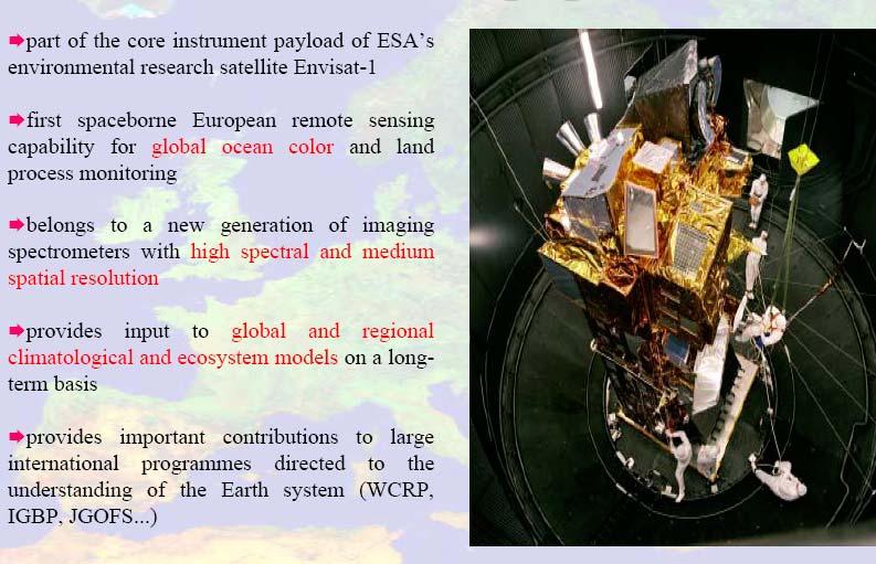
1 ASAR, MERIS and AATSR products Francesco Sarti and Steffen Dransfeld ESA/ESRIN 25 February 2008
: Nominal reference orbit of mean altitude 800 km, 35 days repeat cycle, 10:00 AM mean local solar time (MLST) descending node, 98.55 deg. inclination.")
2 ENVISAT Launched in Sun-synchronous polar orbit (SSO): Nominal reference orbit of mean altitude 800 km, 35 days repeat cycle, 10:00 AM mean local solar time (MLST) descending node, deg. inclination. Dimensions: - Launch configuration: length 10.5m - In-Orbit Configuration: 26m x 10m x 5m Mass: - Total satellite 8140 Kg (including 319 Kg hydrazine) - Payload 2050 Kg Solar Array power: 6.5 kw (EOL) Average Power demand: Sun Eclipse (watts) (watts) Payload Satellite Launch vehicle: Ariane 5 (single launch)
3 Advanced Synthetic Aperture RADAR (ASAR) TECHNICAL CHARACTERISTICS: Sensor Type: Imaging microwave radars Accuracy: Radiometric resolution in range: db Spatial Resolution: Image, Wave and Alternating Polarisation modes: approx 30m x 30m.. Wide Swath mode: approx 150m x 150m.. Global Monitoring mode: approx 1000m x 1000m. Swath Width: Image and alternating polarisation modes: km (depending on incidence angle: degrees), Wave mode: 5km, Wide swath and global monitoring modes: 400km or more Waveband: Applications: Microwave: C-band, C with choice of 5 polarisation modes (VV, HH, VV/HH, HV/HH, or VH/VV) Ocean and Coast (Ocean Currents and Topography) Land (Landscape Topography) Snow and Ice (Snow and Ice)


4 About ASAR IM AP WS GM WV Image Mode 7 beams: deg. inc. angle VV or HH polarisation Swath width: 56 Km 106 Km Wide Swath & Global Monitoring Mode 5 ScanSAR beams VV or HH polarisation Swath width: ~ 400 Km Alternating Polarisation Mode 7 beams: deg. inc. angle VV/HH, VV/VH and HH/HV polarisation Swath width: 56 Km 106 Km Wave Mode 7 beams: deg. inc. angle + 2 alternate beams capability VV or HH polarisation 1 imagette every 100 Km

5 ASAR Image Mode Swaths ASAR provides dual-channel data: in Alternating Polarization Mode, it provides one of three different channel combinations: VV and HH HH and HV VV and VH Tx Rx Tx Rx
6 ASAR acquisition modes Asar Image mode (IM) VV or HH polarization images from any of 7 selectable swaths. Swath width between approximately 56 Km (swath 7) and 100 Km (swath 1) across-track. Spatial resolution of approximately 30m (for precision product) ASAR Alternating polarization mode (AP) Two co-registered images per acquisition, from any of 7 selectable swaths. HH/VV, HH/HV or VV/VH polarization pairs possible. Spatial resolution of approximately 30m (for precision products)
7 ASAR acquisition mode ASAR Wide Swath Mode (WS) 400 Km by 400 Km wide swath image. Spatial resolution of approximately 150m by 150m for nominal product. VV or HH polarization ASAR Global Monitoring Mode (GM) Spatial resolution of approximately 1Km in azimuth by 1Km in range for nominal product. Swath 400 Km Up to a full orbit of coverage, HH or VV polarization
8 ENVISAT Product Levels Data products Radar Imagery Envisat s data products are divided into three categories Level 0, 1 or 2 depending on the amount of processing needed to transform raw satellite data. Level 0: raw satellite data

9 Product Level 0 (raw satellite data)
10 Product Level 1 f1
11 Slide 10 f1 To be extended to the case of ALOS PalSAR. Remark: level 1.1 is phase-preserving (for polarimetric processing with POLSARPRO), level 1.5 is not fsarti, 03/03/2008

12 Product description For details see the ASAR Handbook available at

13 This ASAR WSM image is the first transmitted via the satellite ARTEMIS. Acquistion: 12-Mar-2003 The variation in grey tone within the Usangu wetlands indicates a spatial variability in soil moisture. As can be seen over the lakes, water is like a mirror for signal radar, reflecting specularly away from the antenna the energy backscattered. As a result, wet areas generate dark grey tones within the image.

14 Poyang Lake, China. 10 June 2007 Example of surface water mapping using Envisat ASAR WSM imagery. June 2007
 that covers the area (medium-low HV and HH backscattering, but HV backscattering higher than HH).")
15 This ASAR APP image shows an area covering the country of Guinea The image is a colour composite where: Red: HV polarised image Green: HH polarised image Blue: Ratio between the amplitude in HH and HV. The brown yellow colour that dominates the image results from the sparse vegetation (savannah) that covers the area (medium-low HV and HH backscattering, but HV backscattering higher than HH). The capital, Conakry is seen in cyan tones as it is densely populated (dominant HH backscattering). From the city of Conakry to northeast is seen a bright fringe in yellow colour due to the increasing of vegetation and human settlements (high HH and HV backscattering). Coastal plains of Guinea are plenty of swamps, seen in blue tones in the image corresponding to wet areas (low HH and HV backscattering and HV lower than HH)


16 Landers (USA) earthquake (1993) Bam (Iran) earthquake (26 Dec. 2003) Envisat ASAR Interferogram Visible fault Bam Blind fault revealed by ASAR ERS-1 SAR Interferogram 35 days apart
 φi φf interferometric phase φ r - φ r = Δφ Acquisition at time 2 φi T R φf Interferogram of the Vajont landslide Δφ = Δφ DISP + Δφ TOPO + Δφ ATMO + Δφ")
17 Techniques: SAR Interferometry (InSAR) Radar interferometry is based on the quantitative Acquisition at time 1 T R comparison (phase difference) between paired complex SAR images (taken at different times, ENVISAT/ERS, or simultaneously, SRTM) φi φf interferometric phase φ r - φ r = Δφ Acquisition at time 2 φi T R φf Interferogram of the Vajont landslide Δφ = Δφ DISP + Δφ TOPO + Δφ ATMO + Δφ NOISE Different techniques exist to separate the phase contribution due to ground displacements (case of non simultaneous acquisitions)


18 Techniques: SAR interferometry Tempo T 0 R 1 tempo T 0 +Δt R 1 = R 2 Δ r 1 acquisition 2 acquisition Laion Landslide Permits to assess ground deformations with centimetric accuracy Δφ = Δφ DISP + Δφ TOPO + Δφ ATMO + Δφ NOISE

 Df = Df TOPO + Df MOV Ground-based: Acquisitions from the same")
19 Techniques: Differential interferometry (DInSAR) SAR Image (ERS) differential interferogram interferometric phase Detection of ground movements occurred in the time span between two acquisitions with an accuracy of a small fraction of wavelength Satellite: Acquisitions from different positions (baseline >0) Df = Df TOPO + Df MOV Ground-based: Acquisitions from the same position (baseline =0) Df = Df MOV


, coincident with")

20 Techniques: Permanent Scatterers pixel by pixel analysis multi-image processing ESA - ERS Los Angeles Processing technique of SAR images which allows to assess deformations with millimetric accuracy on single specific points (PS), coincident with highly reflective elements on the ground surface 35 giorni 100 Km Dataset of SAR images 100 Km tempo


21 Overflowing Sliding inner slope Overtopping Plastic horizontal sliding BLUE Below Sea level km of water barriers: 3565 km primary water barriers (big rivers, sea, IJsselmeer, Markermeer), >14000 km regional water barriers Piping Nipping ice On the potential of PS-InSAR for monitoring dikes in the Netherlands Courtesy R. Hanssen Delft Institute of Earth Observation and Space Systems


22 ASAR Training Course, Hanoi, 25 February 7 March 2008 dike monitoring Landsat background, with PSI-dike results of 9 frames superposed ( ) On the potential of PS-InSAR for monitoring dikes in the Netherlands Courtesy Ramon Hanssen, Delft Institute of Earth Observation and Space Systems
23 More Information on ASAR Data ESA webpage containing general information about ASAR Envisat ASAR product handbook: ok.2_2.pdf Contains all information about different ASAR products, their formats, how they are generated, what they are used for, etc.
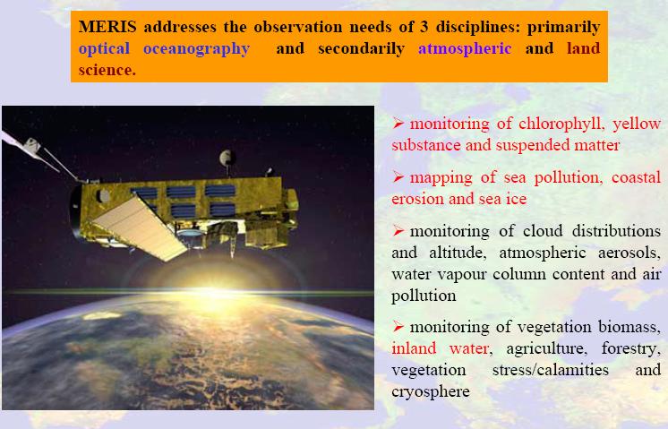
24 Medium Resolution Imaging Spectrometer (MERIS) TECHNICAL CHARACTERISTICS: Sensor Type: Spatial Resolution: Swath Width: Waveband: Applications: Imaging multispectral radiometer (vis( vis/nir) Ocean: 1040m x 1200 m, Land & coast: 260m x 300m 1150km, global coverage every 3 days VIS-NIR: 15 bands selectable across range: 390 nm to 1040 nm (bandwidth programmable between 2.5 and 30 nm) Ocean and Coast (Ocean Colour/Biology) Land (Vegetation) Atmosphere (Clouds, Precipitation)


25 Pushbroom Imager ( 5 cameras) Total swath width: 1150 Km Full Resolution: 300 m Reduced resolution: 1200 m About MERIS VIS-NIR Spectrometer within spectral range: 390 to 1040 Nanometers 15 bands electronically programmable (in width and position) 1150 km
26
27

28


29

30

31

32 Processing levels available

33

34 Level 1b (geolocated, calibrated TOA radiances) Structure Spectral bands: Radiance measurements at all 15 different wavelengths

35

36

37

38 This MERIS FR image shows two huge sand dune seas in the Fezzan region of southwestern Libya. Image Acquired: 24 Nov Spatial Resolution: 300 m Swath Width 672 km A persistent high-pressure zone centred over Libya keeps the heart of the Sahara completely arid for years at a time, but research has discovered evidence of 'paleolakes' in this region associated with a wetter and more fertile past. Libya today has no permanent rivers or water bodies, but has various vast fossil aquifers. These natural underground basins hold enormous amounts of fresh water.

39 MERIS image showing phytoplankton upwelling, Mauritania Acquistion: 22-Mar- 2002
.")
40 In this MERIS image the contrast can clearly be seen between the desert areas of Senegal in the north to the vegetated coastal plains of Guinea- Bissau, The Gambia and Southern Senegal (shown in red on the image). The green colour of the sea around the islands of the Buagos Archipelago is caused by sediment being swept out to sea from the river Acquistion: 24-Feb-2004

41 One of the first images acquired by Envisat, this MERIS image shows the complex river system inside Casamance with its heavy discharge into the sea. A series of such images are needed to monitor the transport of sediment which arises from inland soil erosion. This scene covers the transition zone between savannah in the north and tropical vegetation in the south. MERIS can also monitor the intensification of land use which leads to increased erosion and soil loss. Acquistion: 22-Mar-2002 Casamance, Senegal

42 Water Quality in Egypt MERIS-based relative water turbidity index MERIS-based relative water chlorophyll-a index 5 May May May May 2006 Examples of MERIS Derived Products
43 More Information on MERIS Data ESA webpage containing general information about MERIS Envisat MERIS product handbook: Contains all information about different MERIS products, their formats, how they are generated, what they are used for, etc.
44 MERIS images (not N1. products but full jpeg in the true colour bands) can be found on: Miravi: Earth Watching: Image Gallery (nice images taken from "image of the week"): Background Regional Mission (places where ENVISAT acquires images by default when there are no programming requests, e.g. major cities, areas prone to disaster - like active volcanoes, etc): (under construction, but hopefully soon ready!)
45 Advanced Along Track Scanning TECHNICAL CHARACTERISTICS: Radiometer (AATSR) Type Accuracy Spatial Resolution: Swath Width: Waveband: Applications: Imaging multi-spectral radiometers (vis( vis/ir) & Multiple direction / polarisation radiometers Sea surface temperature: <0.5K over 0.5 deg x 0.5 deg (lat/long) area with 80% cloud cover. Land surface temperature: 0.1K (relative) IR ocean channels: 1km x 1km, Visible land channels: 1km x 1km 500km VIS - NIR: : 0.555, 0.659, micrometers, SWIR: : 1.6 micrometers, MWIR: : 3.7 micrometers, TIR: : 10.85, 12 micrometers Ocean and Coast (Sea Surface Temperature),, Atmosphere (Atmospheric chemistry (Trace Gases, Clouds), Land (Vegetation)
46

47

48

49


50 RGB combination of: Red = 870 micrometer reflectance channel Green = 670 micrometer reflectance channel Blue = 550 micrometer reflectance channel AATSR image over Caspian Sea


51 Lake surface temperature Derived from 3 AATSR scenes: 16-AUG AUG AUG-2006
52 More Information on AATSR Data ESA webpage containing general information about AATSR: Envisat AATSR product handbook: Contains all information about different AATSR products: their formats, how they are generated, what they are used for, etc.
Copernicus Introduction Lisbon, Portugal 13 th & 14 th February 2014
 Copernicus Introduction Lisbon, Portugal 13 th & 14 th February 2014 Contents Introduction GMES Copernicus Six thematic areas Infrastructure Space data An introduction to Remote Sensing In-situ data Applications
The Sentinel-1 Constellation
 The Sentinel-1 Constellation Evert Attema, Sentinel-1 Mission & System Manager AGRISAR and EAGLE Campaigns Final Workshop 15-16 October 2007 ESA/ESTECNoordwijk, The Netherlands Sentinel-1 Programme Sentinel-1
remote sensing? What are the remote sensing principles behind these Definition
 Introduction to remote sensing: Content (1/2) Definition: photogrammetry and remote sensing (PRS) Radiation sources: solar radiation (passive optical RS) earth emission (passive microwave or thermal infrared
ACTIVE SENSORS RADAR
 ACTIVE SENSORS RADAR RADAR LiDAR: Light Detection And Ranging RADAR: RAdio Detection And Ranging SONAR: SOund Navigation And Ranging Used to image the ocean floor (produce bathymetic maps) and detect objects
RADAR (RAdio Detection And Ranging)
") RADAR (RAdio Detection And Ranging) CLASSIFICATION OF NONPHOTOGRAPHIC REMOTE SENSORS PASSIVE ACTIVE DIGITAL CAMERA THERMAL (e.g. TIMS) VIDEO CAMERA MULTI- SPECTRAL SCANNERS VISIBLE & NIR MICROWAVE Real
RADAR (RAdio Detection And Ranging) CLASSIFICATION OF NONPHOTOGRAPHIC REMOTE SENSORS PASSIVE ACTIVE DIGITAL CAMERA THERMAL (e.g. TIMS) VIDEO CAMERA MULTI- SPECTRAL SCANNERS VISIBLE & NIR MICROWAVE Real
Review. Guoqing Sun Department of Geography, University of Maryland ABrief
 Review Guoqing Sun Department of Geography, University of Maryland gsun@glue.umd.edu ABrief Introduction Scattering Mechanisms and Radar Image Characteristics Data Availability Example of Applications
European Space Agency and IPY
 European Space Agency and IPY ESA supports IPY 2007-2008 activities: First ESA step was a dedicated Announcement Opportunity (AO) for EO data provision in support IPY, released in 2006, with data provision
Polarisation Capabilities and Status of TerraSAR-X
 Polarisation Capabilities and Status of TerraSAR-X Irena Hajnsek, Josef Mittermayer, Stefan Buckreuss, Kostas Papathanassiou German Aerospace Center Microwaves and Radar Institute irena.hajnsek@dlr.de
Introduction to Radar
 National Aeronautics and Space Administration ARSET Applied Remote Sensing Training http://arset.gsfc.nasa.gov @NASAARSET Introduction to Radar Jul. 16, 2016 www.nasa.gov Objective The objective of this
ERS/ENVISAT ASAR Data Products and Services
 ERS/ENVISAT ASAR Data Products and Services Andrea Celentano Business Manager celentan@eurimage.com What is Eurimage? Founded in 1989 Current shareholders: Since 1989 Commercial Partner of the European
RADAR REMOTE SENSING
 RADAR REMOTE SENSING Jan G.P.W. Clevers & Steven M. de Jong Chapter 8 of L&K 1 Wave theory for the EMS: Section 1.2 of L&K E = electrical field M = magnetic field c = speed of light : propagation direction
SARscape Modules for ENVI
 Visual Information Solutions SARscape Modules for ENVI Read, process, analyze, and output products from SAR data. ENVI. Easy to Use Tools. Proven Functionality. Fast Results. DEM, based on TerraSAR-X-1
On the use of water color missions for lakes in 2021
 Lakes and Climate: The Role of Remote Sensing June 01-02, 2017 On the use of water color missions for lakes in 2021 Cédric G. Fichot Department of Earth and Environment 1 Overview 1. Past and still-ongoing
TerraSAR-X Applications Guide
 TerraSAR-X Applications Guide Extract: Change Detection and Monitoring: Geospatial / Image Intelligence April 2015 Airbus Defence and Space Geo-Intelligence Programme Line Change Detection and Monitoring:
Geospatial Vision and Policies Korean Industry View 26 November, 2014 SI Imaging Services
 Geospatial Vision and Policies Korean Industry View 26 November, 2014 SI Imaging Services Distribution Limitation, SI Imaging Services Proprietary Data : The data contained in this document, without the
ACTIVE MICROWAVE REMOTE SENSING OF LAND SURFACE HYDROLOGY
 Basics, methods & applications ACTIVE MICROWAVE REMOTE SENSING OF LAND SURFACE HYDROLOGY Annett.Bartsch@polarresearch.at Active microwave remote sensing of land surface hydrology Landsurface hydrology:
The Current Status and Brief Results of Engineering Model for PALSAR-2 onboard ALOS-2 and Science Project
 The Current Status and Brief Results of Engineering Model for PALSAR-2 onboard ALOS-2 and Science Project + The 16 th KC meeting Japan Aerospace Exploration Agency Masanobu Shimada, Yukihiro KANKAKU The
The Global Imager (GLI)
") The Global Imager (GLI) Launch : Dec.14, 2002 Initial check out : to Apr.14, 2003 (~L+4) First image: Jan.25, 2003 Second image: Feb.6 and 7, 2003 Calibration and validation : to Dec.14, 2003(~L+4) for
The Global Imager (GLI) Launch : Dec.14, 2002 Initial check out : to Apr.14, 2003 (~L+4) First image: Jan.25, 2003 Second image: Feb.6 and 7, 2003 Calibration and validation : to Dec.14, 2003(~L+4) for
SAR Interferometry Capabilities of Canada's planned SAR Satellite Constellation
 SAR Interferometry Capabilities of Canada's planned SAR Satellite Constellation Dirk Geudtner, Guy Séguin,, Ralph Girard Canadian Space Agency RADARSAT Follow-on Program CSA is in the middle of a Phase
9/12/2011. Training Course Remote Sensing Basic Theory & Image Processing Methods September 2011
 Training Course Remote Sensing Basic Theory & Image Processing Methods 19 23 September 2011 Popular Remote Sensing Sensors & their Selection Michiel Damen (September 2011) damen@itc.nl 1 Overview Low resolution
ASAR Training Course, Hanoi, 25 February 7 March 2008 Introduction to Radar Interferometry
 Introduction to Radar Interferometry Presenter: F.Sarti (ESA/ESRIN) 1 Imaging Radar : reminder 2 Physics of radar Potentialities of radar All-weather observation system (active system) Penetration capabilities
Francesco Holecz. TUBE II meeting - 17 June Land Degradation. Land Degradation
 Land Degradation Francesco Holecz Objective To identify and monitor land degraded areas, in particular those related to agricultural and pastoral activities. Following products are generated: Land cover
SAR Multi-Temporal Applications
 SAR Multi-Temporal Applications 83230359-DOC-TAS-EN-001 Contents 2 Advantages of SAR Remote Sensing Technology All weather any time Frequencies and polarisations Interferometry and 3D mapping Change Detection
MERIS instrument. Muriel Simon, Serco c/o ESA
 MERIS instrument Muriel Simon, Serco c/o ESA Workshop on Sustainable Development in Mountain Areas of Andean Countries Mendoza, Argentina, 26-30 November 2007 ENVISAT MISSION 2 Mission Chlorophyll case
EE 529 Remote Sensing Techniques. Introduction
 EE 529 Remote Sensing Techniques Introduction Course Contents Radar Imaging Sensors Imaging Sensors Imaging Algorithms Imaging Algorithms Course Contents (Cont( Cont d) Simulated Raw Data y r Processing
Aral Sea profile Selection of area 24 February April May 1998
 250 km Aral Sea profile 1960 1960 1985 1986 1987 1988 1989 1990 1991 1992 1993 1994 1995 1996 1997 1998 2010? Selection of area Area of interest Kzyl-Orda Dried seabed 185 km Syrdarya river Aral Sea Salt
New capabilities in Earth Observation for agriculture
 New capabilities in Earth Observation for agriculture Prof. Katarzyna Dabrowska-Zielinska Head of Remote Sensing Department Institute of Geodesy and Cartography Modzelewskiego 27 Street 02-679 Warsaw Poland
Sentinel-1 System Overview
 Sentinel-1 System Overview Dirk Geudtner, Rámon Torres, Paul Snoeij, Malcolm Davidson European Space Agency, ESTEC Global Monitoring for Environment and Security (GMES) EU-led program aiming at providing
Remote Sensing for Resource Management
 Remote Sensing for Resource Management Ebenezer Nyadjro US Naval Research Lab/UNO RMU Summer Program (July 31-AUG 4, 2017) Motivation Polluted Pra River Motivation. 3 Motivation Polluted Pra River Motivation.
Outline. Introduction. Introduction: Film Emulsions. Sensor Systems. Types of Remote Sensing. A/Prof Linlin Ge. Photographic systems (cf(
 GMAT x600 Remote Sensing / Earth Observation Types of Sensor Systems (1) Outline Image Sensor Systems (i) Line Scanning Sensor Systems (passive) (ii) Array Sensor Systems (passive) (iii) Antenna Radar
IKONOS High Resolution Multispectral Scanner Sensor Characteristics
 High Spatial Resolution and Hyperspectral Scanners IKONOS High Resolution Multispectral Scanner Sensor Characteristics Launch Date View Angle Orbit 24 September 1999 Vandenberg Air Force Base, California,
Sentinel-1 Overview. Dr. Andrea Minchella
 Dr. Andrea Minchella 21-22/01/2016 ESA SNAP-Sentinel-1 Training Course Satellite Applications Catapult - Electron Building, Harwell, Oxfordshire Contents Sentinel-1 Mission Sentinel-1 SAR Modes Sentinel-1
Sentinel-1 Calibration and Performance
 Sentinel-1 Calibration and Performance Paul Snoeij Evert Attema Björn Rommen Nicolas Floury Berthyl Duesmann Malcolm Davidson Ramon Torres European Space Agency Sentinel-1 Mission Objectives Component
SARscape for ENVI. A Complete SAR Analysis Solution
 SARscape for ENVI A Complete SAR Analysis Solution IDL and ENVI A Foundation for SARscape IDL The Data Analysis & Visualization Platform Data Access: IDL supports virtually every data format, type and
XSAT Ground Segment at CRISP
 XSAT Ground Segment at CRISP LIEW Soo Chin Head of Research, CRISP http://www.crisp.nus.edu.sg 5 th JPTM for Sentinel Asia Step-2, 14-16 Nov 2012, Daejeon, Korea Centre for Remote Imaging, Sensing and
The studies began when the Tiros satellites (1960) provided man s first synoptic view of the Earth s weather systems.
 provided man s first synoptic view of the Earth s weather systems.") Remote sensing of the Earth from orbital altitudes was recognized in the mid-1960 s as a potential technique for obtaining information important for the effective use and conservation of natural resources.
Remote sensing of the Earth from orbital altitudes was recognized in the mid-1960 s as a potential technique for obtaining information important for the effective use and conservation of natural resources.
Advanced Optical Satellite (ALOS-3) Overviews
 Overviews") K&C Science Team meeting #24 Tokyo, Japan, January 29-31, 2018 Advanced Optical Satellite (ALOS-3) Overviews January 30, 2018 Takeo Tadono 1, Hidenori Watarai 1, Ayano Oka 1, Yousei Mizukami 1, Junichi
K&C Science Team meeting #24 Tokyo, Japan, January 29-31, 2018 Advanced Optical Satellite (ALOS-3) Overviews January 30, 2018 Takeo Tadono 1, Hidenori Watarai 1, Ayano Oka 1, Yousei Mizukami 1, Junichi
NON-PHOTOGRAPHIC SYSTEMS: Multispectral Scanners Medium and coarse resolution sensor comparisons: Landsat, SPOT, AVHRR and MODIS
 NON-PHOTOGRAPHIC SYSTEMS: Multispectral Scanners Medium and coarse resolution sensor comparisons: Landsat, SPOT, AVHRR and MODIS CLASSIFICATION OF NONPHOTOGRAPHIC REMOTE SENSORS PASSIVE ACTIVE DIGITAL
RADARSAT-2 Program Update Daniel De Lisle Canadian Space Agency
 RADARSAT-2 Program Update Daniel De Lisle Canadian Space Agency Presentation outline RADARSAT-1 Update RADARSAT-2 Mission description Mission Objectives System Characteristics Data Commercialization/Allocation
ENVISAT ASAR MONTHLY REPORT MARCH 2012
 ENVISAT ASAR MONTHLY REPORT MARCH 2012 PUBLIC SUMMARY prepared by/préparé par IDEAS SAR Team reference/réference ENVI-CLVL-EOPG-TN-04-0009 issue/édition 73 revision/révision 0 date of issue/date d édition
Introduction to radar. interferometry
 Introduction to radar Introduction to Radar Interferometry interferometry Presenter: F.Sarti (ESA/ESRIN) With kind contribution by the Radar Department of CNES All-weather observation system (active system)
Futrajaya, Malaysia JULY 12, Jeong Heon SONG. Korea Aerospace Research Institution
 J P T M 2 0 1 1 Futrajaya, Malaysia JULY 12, 2011 Jeong Heon SONG Korea Aerospace Research Institution Outline Contribution of KARI Sentinel Asia / Data Provider Node International Charter KARI Space Activities
Soil moisture retrieval using ALOS PALSAR
 Soil moisture retrieval using ALOS PALSAR T. J. Jackson, R. Bindlish and M. Cosh USDA ARS Hydrology and Remote Sensing Lab, Beltsville, MD J. Shi University of California Santa Barbara, CA November 6,
GMES Sentinel-1 Transponder Development
 GMES Sentinel-1 Transponder Development Paul Snoeij Evert Attema Björn Rommen Nicolas Floury Malcolm Davidson ESA/ESTEC, European Space Agency, Noordwijk, The Netherlands Outline 1. GMES Sentinel-1 overview
Envisat and ERS missions: data and services
 FRINGE 2005 Workshop Envisat and ERS missions: and services Henri LAUR Envisat Mission Manager Our top objective: ease access to Earth Observation Common objective for all missions handled by ESA: Envisat,
Introduction Active microwave Radar
 RADAR Imaging Introduction 2 Introduction Active microwave Radar Passive remote sensing systems record electromagnetic energy that was reflected or emitted from the surface of the Earth. There are also
SAR Remote Sensing (Microwave Remote Sensing)
") iirs SAR Remote Sensing (Microwave Remote Sensing) Synthetic Aperture Radar Shashi Kumar shashi@iirs.gov.in Electromagnetic Radiation Electromagnetic radiation consists of an electrical field(e) which
iirs SAR Remote Sensing (Microwave Remote Sensing) Synthetic Aperture Radar Shashi Kumar shashi@iirs.gov.in Electromagnetic Radiation Electromagnetic radiation consists of an electrical field(e) which
ASAR WIDE-SWATH SINGLE-LOOK COMPLEX PRODUCTS: PROCESSING AND EXPLOITATION POTENTIAL
 ASAR WIDE-SWATH SINGLE-LOOK COMPLEX PRODUCTS: PROCESSING AND EXPLOITATION POTENTIAL Ralph Cordey (1), Tim Pearson (2), Yves-Louis Desnos (3), Betlem Rosich-Tell (3) (1) European Space Agency, ESTEC, Keplerlaan
ALOS and PALSAR. Masanobu Shimada
 ALOS and PALSAR Masanobu Shimada Earth Observation Research Center, National Space Development Agency of Japan, Harumi 1-8-10, Harumi island triton square office tower X 22, Chuo-Ku, Tokyo-To, Japan, 104-6023,
Change detection in cultural landscapes
 9-11 November 2015 ESA-ESRIN, Frascati (Rome), Italy 3 rd ESA-EARSeL Course on Remote Sensing for Archaeology Day 3 Change detection in cultural landscapes DeodatoTapete (1,2) & Francesca Cigna (1,2) (1)
Remote Sensing : An overview
 Remote Sensing : An overview Contents Introduction Historical review Applications Electromagnetic spectrum Interaction with atmosphere- Atmospheric windows Spectral signature Multispectral Space Multispectral
PALSAR SCANSAR SCANSAR Interferometry
 PALSAR SCANSAR SCANSAR Interferometry Masanobu Shimada Japan Aerospace Exploration Agency Earth Observation Research Center ALOS PI symposium, Greece Nov. 6 2008 1 Introduction L-band PALSAR strip mode
Synthetic aperture RADAR (SAR) principles/instruments October 31, 2018
 principles/instruments October 31, 2018") GEOL 1460/2461 Ramsey Introduction to Remote Sensing Fall, 2018 Synthetic aperture RADAR (SAR) principles/instruments October 31, 2018 I. Reminder: Upcoming Dates lab #2 reports due by the start of next
GEOL 1460/2461 Ramsey Introduction to Remote Sensing Fall, 2018 Synthetic aperture RADAR (SAR) principles/instruments October 31, 2018 I. Reminder: Upcoming Dates lab #2 reports due by the start of next
Passive Microwave Sensors LIDAR Remote Sensing Laser Altimetry. 28 April 2003
 Passive Microwave Sensors LIDAR Remote Sensing Laser Altimetry 28 April 2003 Outline Passive Microwave Radiometry Rayleigh-Jeans approximation Brightness temperature Emissivity and dielectric constant
IMPACT OF BAQ LEVEL ON INSAR PERFORMANCE OF RADARSAT-2 EXTENDED SWATH BEAM MODES
 IMPACT OF BAQ LEVEL ON INSAR PERFORMANCE OF RADARSAT-2 EXTENDED SWATH BEAM MODES Jayson Eppler (1), Mike Kubanski (1) (1) MDA Systems Ltd., 13800 Commerce Parkway, Richmond, British Columbia, Canada, V6V
Microwave remote sensing. Rudi Gens Alaska Satellite Facility Remote Sensing Support Center
 Microwave remote sensing Alaska Satellite Facility Remote Sensing Support Center 1 Remote Sensing Fundamental The entire range of EM radiation constitute the EM Spectrum SAR sensors sense electromagnetic
THE NASA/JPL AIRBORNE SYNTHETIC APERTURE RADAR SYSTEM. Yunling Lou, Yunjin Kim, and Jakob van Zyl
 THE NASA/JPL AIRBORNE SYNTHETIC APERTURE RADAR SYSTEM Yunling Lou, Yunjin Kim, and Jakob van Zyl Jet Propulsion Laboratory California Institute of Technology 4800 Oak Grove Drive, MS 300-243 Pasadena,
Synthetic Aperture Radar Interferometry (InSAR) Technique (Lecture I- Tuesday 11 May 2010)
 Technique (Lecture I- Tuesday 11 May 2010)") Synthetic Aperture Radar Interferometry () Technique (Lecture I- Tuesday 11 May 2010) ISNET/CRTEAN Training Course on Synthetic Aperture Radar (SAR) Imagery: Processing, Interpretation and Applications
Synthetic Aperture Radar Interferometry () Technique (Lecture I- Tuesday 11 May 2010) ISNET/CRTEAN Training Course on Synthetic Aperture Radar (SAR) Imagery: Processing, Interpretation and Applications
How to access EO data
 How to access EO data PAC USF USF PDHS LRAC USCF PDCC Europe s expanding EO Capability Continuity & Evolution Wind Scatterometer (Low rate) all weather; day and night SAR Antenna (C-Band, 5.3 GHz) image
Specificities of Near Nadir Ka-band Interferometric SAR Imagery
 Specificities of Near Nadir Ka-band Interferometric SAR Imagery Roger Fjørtoft, Alain Mallet, Nadine Pourthie, Jean-Marc Gaudin, Christine Lion Centre National d Etudes Spatiales (CNES), France Fifamé
An Introduction to Remote Sensing & GIS. Introduction
 An Introduction to Remote Sensing & GIS Introduction Remote sensing is the measurement of object properties on Earth s surface using data acquired from aircraft and satellites. It attempts to measure something
Lecture 6: Multispectral Earth Resource Satellites. The University at Albany Fall 2018 Geography and Planning
 Lecture 6: Multispectral Earth Resource Satellites The University at Albany Fall 2018 Geography and Planning Outline SPOT program and other moderate resolution systems High resolution satellite systems
Remote sensing radio applications/ systems for environmental monitoring
 Remote sensing radio applications/ systems for environmental monitoring Alexandre VASSILIEV ITU Radiocommunication Bureau phone: +41 22 7305924 e-mail: alexandre.vassiliev@itu.int 1 Source: European Space
Interpreting land surface features. SWAC module 3
 Interpreting land surface features SWAC module 3 Interpreting land surface features SWAC module 3 Different kinds of image Panchromatic image True-color image False-color image EMR : NASA Echo the bat
SAR missions for oceanography at the European Space Agency
 SAR missions for oceanography at the European Space Agency ERS-1, ERS-2, Envisat, Sentinel-1A, Sentinel-1B, ESA 3 rd Party Missions (ALOS) Prepared by ESA teams and ESA supporting companies ESA and SAR
SAR Remote Sensing. Introduction into SAR. Data characteristics, challenges, and applications.
 SAR Remote Sensing Introduction into SAR. Data characteristics, challenges, and applications. PD Dr. habil. Christian Thiel, Friedrich-Schiller-University Jena DLR-HR Jena & Friedrich-Schiller-University
1. Theory of remote sensing and spectrum
 1. Theory of remote sensing and spectrum 7 August 2014 ONUMA Takumi Outline of Presentation Electromagnetic wave and wavelength Sensor type Spectrum Spatial resolution Spectral resolution Mineral mapping
Microwave Remote Sensing (1)
") Microwave Remote Sensing (1) Microwave sensing encompasses both active and passive forms of remote sensing. The microwave portion of the spectrum covers the range from approximately 1cm to 1m in wavelength.
Microwave Remote Sensing (1) Microwave sensing encompasses both active and passive forms of remote sensing. The microwave portion of the spectrum covers the range from approximately 1cm to 1m in wavelength.
All rights reserved. ENVI, IDL and Jagwire are trademarks of Exelis, Inc. All other marks are the property of their respective owners.
 SAR Analysis Made Easy with SARscape 5.1 All rights reserved. ENVI, IDL and Jagwire are trademarks of Exelis, Inc. All other marks are the property of their respective owners. 2014, Exelis Visual Information
Japan's Greenhouse Gases Observation from Space
 1 Workshop on EC CEOS Priority on GHG Monitoring Japan's Greenhouse Gases Observation from Space 18 June, 2018@Ispra, Italy Masakatsu NAKAJIMA Japan Aerospace Exploration Agency Development and Operation
MODULE 9 LECTURE NOTES 2 ACTIVE MICROWAVE REMOTE SENSING
 MODULE 9 LECTURE NOTES 2 ACTIVE MICROWAVE REMOTE SENSING 1. Introduction Satellite sensors are capable of actively emitting microwaves towards the earth s surface. An active microwave system transmits
SATELLITE OCEANOGRAPHY
 SATELLITE OCEANOGRAPHY An Introduction for Oceanographers and Remote-sensing Scientists I. S. Robinson Lecturer in Physical Oceanography Department of Oceanography University of Southampton JOHN WILEY
Sentinel-2 Products and Algorithms
 Sentinel-2 Products and Algorithms Ferran Gascon (Sentinel-2 Data Quality Manager) Workshop Preparations for Sentinel 2 in Europe, Oslo 26 November 2014 Sentinel-2 Mission Mission Overview Products and
RADAR INTERFEROMETRY FOR SAFE COAL MINING IN CHINA
 RADAR INTERFEROMETRY FOR SAFE COAL MINING IN CHINA L. Ge a, H.-C. Chang a, A. H. Ng b and C. Rizos a Cooperative Research Centre for Spatial Information School of Surveying & Spatial Information Systems,
Sensor resolutions from space: the tension between temporal, spectral, spatial and swath. David Bruce UniSA and ISU
 Sensor resolutions from space: the tension between temporal, spectral, spatial and swath David Bruce UniSA and ISU 1 Presentation aims 1. Briefly summarize the different types of satellite image resolutions
Interferometric Cartwheel 1
 The Interferometric CartWheel A wheel of passive radar microsatellites for upgrading existing SAR projects D. Massonnet, P. Ultré-Guérard (DPI/EOT) E. Thouvenot (DTS/AE/INS/IR) Interferometric Cartwheel
Status of Sentinel-1 and acquisition plans for GFOI
 Status of Sentinel-1 and acquisition plans for GFOI Frank Martin Seifert, Pierre Potin, Johannes Roeder, ESA Earth Observation Programme 5 th Space Data Coordination, ESRIN, Frascati, 24 February 2014
Sentinels Data Collection
 H2020-EO-1-2014 Sentinels Data Collection AUTHOR Mattia Marconcini (DLR) DATE 19 January 2017 ISSUE 1.0 GRANT AGREEMENT no 637519 DISSEMINATION LEVEL PU CONTRIBUTORS Page 2 of 20 CONTENTS 1 Introduction...
Introduction to KOMPSAT
 Introduction to KOMPSAT September, 2016 1 CONTENTS 01 Introduction of SIIS 02 KOMPSAT Constellation 03 New : KOMPSAT-3 50 cm 04 New : KOMPSAT-3A 2 KOMPSAT Constellation KOMPSAT series National space program
Introduction of Satellite Remote Sensing
 Introduction of Satellite Remote Sensing Spatial Resolution (Pixel size) Spectral Resolution (Bands) Resolutions of Remote Sensing 1. Spatial (what area and how detailed) 2. Spectral (what colors bands)
Sub-Mesoscale Imaging of the Ionosphere with SMAP
 Sub-Mesoscale Imaging of the Ionosphere with SMAP Tony Freeman Xiaoqing Pi Xiaoyan Zhou CEOS Workshop, ASF, Fairbanks, Alaska, December 2009 1 Soil Moisture Active-Passive (SMAP) Overview Baseline Mission
TerraSAR-X Mission: Application and Data Access
 TerraSAR-X Mission: Application and Data Access Irena Hajnsek & TSX TEAM German Aerospace Center Microwaves and Radar Institute Pol-InSAR Research Group 2 years in Orbit (since June 2007) irena.hajnsek@dlr.de
ANALYSIS OF LAND COVER AND LAND USE CHANGES USING SENTINEL-2 IMAGES
 DOI 10.1515/pesd-2016-0034 PESD, VOL. 10, no. 2, 2016 ANALYSIS OF LAND COVER AND LAND USE CHANGES USING SENTINEL-2 IMAGES Nicoleta Iurist (Dumitrașcu) 1,, Florian Stătescu 2, Iustina Lateș 3 Key words,
Indian Remote Sensing Satellites
 Resourcesat-1 Indian Remote Sensing Satellites -Current & Future Resourcesat Missions - Presented by: Timothy J. Puckorius Chairman & CEO EOTec 1 Presentation Topics India s Earth Observation Heritage
Water Body Extraction Research Based on S Band SAR Satellite of HJ-1-C
 Cloud Publications International Journal of Advanced Remote Sensing and GIS 2016, Volume 5, Issue 2, pp. 1514-1523 ISSN 2320-0243, Crossref: 10.23953/cloud.ijarsg.43 Research Article Open Access Water
AVHRR/3 Operational Calibration
 AVHRR/3 Operational Calibration Jörg Ackermann, Remote Sensing and Products Division 1 Workshop`Radiometric Calibration for European Missions, 30/31 Aug. 2017`,Frascati (EUM/RSP/VWG/17/936014) AVHRR/3
TerraSAR-X Applications Guide
 TerraSAR-X Applications Guide Extract: Maritime Monitoring: Ship Detection April 2015 Airbus Defence and Space Geo-Intelligence Programme Line Maritime Monitoring: Ship Detection Issue Maritime security
Indian Remote Sensing Satellites
 Resourcesat-1 Cartosat-1 Indian Remote Sensing Satellites -Current & Future Missions - Presented by: Timothy J. Puckorius Chairman & CEO EOTec 1 Presentation Topics Who is EOTec India s Earth Observation
Remote Sensing: John Wilkin IMCS Building Room 211C ext 251. Active microwave systems (1) Satellite Altimetry
 Satellite Altimetry") Remote Sensing: John Wilkin wilkin@marine.rutgers.edu IMCS Building Room 211C 732-932-6555 ext 251 Active microwave systems (1) Satellite Altimetry Active microwave instruments Scatterometer (scattering
Remote Sensing: John Wilkin wilkin@marine.rutgers.edu IMCS Building Room 211C 732-932-6555 ext 251 Active microwave systems (1) Satellite Altimetry Active microwave instruments Scatterometer (scattering
HIGH RESOLUTION DIFFERENTIAL INTERFEROMETRY USING TIME SERIES OF ERS AND ENVISAT SAR DATA
 HIGH RESOLUTION DIFFERENTIAL INTERFEROMETRY USING TIME SERIES OF ERS AND ENVISAT SAR DATA Javier Duro 1, Josep Closa 1, Erlinda Biescas 2, Michele Crosetto 2, Alain Arnaud 1 1 Altamira Information C/ Roger
Light penetration within a clear water body. E z = E 0 e -kz
 THE BLUE PLANET 1 2 Light penetration within a clear water body E z = E 0 e -kz 3 4 5 Pure Seawater Phytoplankton b w 10-2 m -1 b w 10-2 m -1 b w, Morel (1974) a w, Pope and Fry (1997) b chl,loisel and
Co-ReSyF RA lecture: Vessel detection and oil spill detection
 This project has received funding from the European Union s Horizon 2020 Research and Innovation Programme under grant agreement no 687289 Co-ReSyF RA lecture: Vessel detection and oil spill detection
Geo/SAT 2 INTRODUCTION TO REMOTE SENSING
 Geo/SAT 2 INTRODUCTION TO REMOTE SENSING Paul R. Baumann, Professor Emeritus State University of New York College at Oneonta Oneonta, New York 13820 USA COPYRIGHT 2008 Paul R. Baumann Introduction Remote
3/31/03. ESM 266: Introduction 1. Observations from space. Remote Sensing: The Major Source for Large-Scale Environmental Information
 Remote Sensing: The Major Source for Large-Scale Environmental Information Jeff Dozier Observations from space Sun-synchronous polar orbits Global coverage, fixed crossing, repeat sampling Typical altitude
ESA Radar Remote Sensing Course ESA Radar Remote Sensing Course Radar, SAR, InSAR; a first introduction
 Radar, SAR, InSAR; a first introduction Ramon Hanssen Delft University of Technology The Netherlands r.f.hanssen@tudelft.nl Charles University in Prague Contents Radar background and fundamentals Imaging
Canadian Space Agency Contribution to STG
 Canadian Space Agency Contribution to STG Canadian Space Agency 1 STG5 Geneva, Nov 30 to Dec 2, 2009 2 Canadian Space Agency ASAP Portefolio: Name Frozen Baseline Sea Ice Min and Max Snapshots Fine Image
Int n r t o r d o u d c u ti t on o n to t o Remote Sensing
 Introduction to Remote Sensing Definition of Remote Sensing Remote sensing refers to the activities of recording/observing/perceiving(sensing)objects or events at far away (remote) places. In remote sensing,
Earth Observation and Sensing Technologies: a focus on Radar Imaging Developments. Riccardo Lanari
 Earth Observation and Sensing Technologies: a focus on Radar Imaging Developments Riccardo Lanari Institute for Electromagnetic Sensing of the Environment (IREA) National Research Council of Italy (CNR)
KOMPSAT Constellation. November 2012 Satrec Initiative
 KOMPSAT Constellation November 2012 Satrec Initiative KOMPSAT Constellation KOMPSAT National program Developed and operated by KARI (Korea Aerospace Research Institute) Dual use : Government & commercial
High resolution ground deformations monitoring by COSMO-SkyMed PSP SAR interferometry
 High resolution ground deformations monitoring by COSMO-SkyMed PSP SAR interferometry Mario Costantini e-geos - an ASI/Telespazio Company, Rome, Italy mario.costantini@e-geos.it Summary COSMO-SkyMed satellite