Francesco Holecz. TUBE II meeting - 17 June Land Degradation. Land Degradation
|
|
|
- Angelina Phillips
- 5 years ago
- Views:
Transcription
1 Land Degradation Francesco Holecz
2 Objective To identify and monitor land degraded areas, in particular those related to agricultural and pastoral activities. Following products are generated: Land cover map Land cover change map Crop acreage and yield Pastoral extent Digital Elevation Model
3 Team Global Monitoring for Food Security ( consortium TUBE II (a meeting Belgian-Swiss-Italian-German - 17 June 2002 partnership). Users Food and Agriculture Organisation (FAO) - GIEWS Unit World Food Programme - VAM Unit FEWS Net - USGS Regional Early Warning Units SADC AGRHYMET RCMRD National Early Warning Units
4 Methodology HighRes Opt HighRes SAR MedRes Opt MedRes SAR Rule based S-T Decision Classifier Spectral Classes Temporal Changes Baseline Map Rule based Decision Classifier Rule based S-T Decision Classifier Spectral Classes Temporal Changes Local to National Scale - Baseline Map -Products Neural Network based on Area Fraction Images Products National Scale
5 Sensors HighRes ASAR Alternating Polarization ALOS PALSAR Fine Beam Thematic Mapper / ETM+ SPOT-4 MedRes MERIS Full Resolution MODIS 500m ASAR Wide Swath ALOS PALSAR ScanSAR
6 Sites GMFS sites K&C sites


7 Validation - Sampling Design M0709 M0710 M0733 M km 250 m 1 km
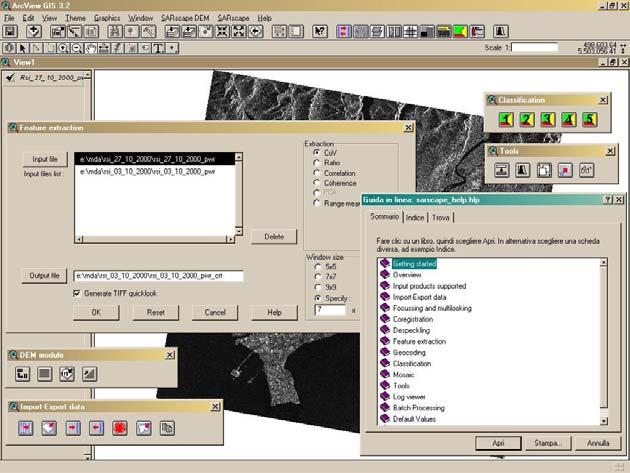
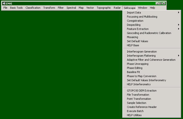
8 Processing Chain - SARscape in Arcview and ENVI Environment
9 Processing Chain - SARscape Basic It includes a set of processing steps for the generation of SAR products based on intensity and coherence. This module is complemented by a optical multi-spectral data processing capabilities and a multi-purpose tool. Focusing This module developed by aresys supports the focusing of RADARSAT-1 (FB,SB,SS), ENVISAT ASAR (IM,AP,WS), and ALOS PALSAR data (FB,SS,PM). Gamma & Gaussian Filter This module developed by Privateers includes a whole family of SAR specific filters. They are particularly efficient to reduce speckle, while preserving the radar reflectivity, the textural properties and the spatial resolution, especially in strongly textured SAR images. Interferometry It supports the processing of Interferometric SAR (2-pass interferometry, InSAR) and Differential Interferometric SAR (n-pass interfereometry, DInSAR) data for the generation of Digital Elevation Model, Coherence, and Land Displacement/Deformation maps.
10 Processing Chain - SARscape ScanSAR Interferometry It extends TUBE the II Interferometry meeting - 17 one June to 2002 the ScanSAR mode, offering the capabilities to generate interferograms over large areas (500 x 500 km). This module developed by aresys combined with the Interferometry one enables also the generation of Digital Elevation Model, Coherence, and Land Displacement/Deformation maps. SAR Polarimetry / Polarimetric Interferometry The PolSAR/PolInSAR module supports the processing of polarimetric (ALOS PALSAR, RADARSAT-2, and TerraSAR-X-1) and polarimetric interferometric (ALOS PALSAR) SAR data. Permanent Scatters The Permanent Scatterers module developed in collaboration with aresys enables to determine mm-scale displacements of individual features on the ground.
11 ALOS PALSAR Processing Geocoded sigma naught image JAXA

12 ALOS PALSAR Processing Geocoded flattened interferogram JAXA

13 ALOS PALSAR Processing - Intensity Lake Urban Forest JAXA
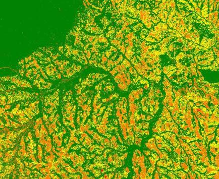
14 Coherence - Non-zero Doppler Annotation <γ>=0.1 <γ>=0.27 <γ>=0.16 JAXA

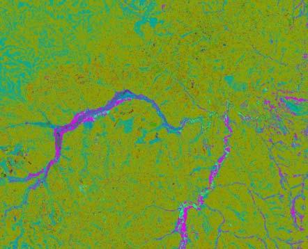
15 Coherence - Zero Doppler Annotation <γ>=0.06 <γ>=0.32 <γ>=0.17 JAXA


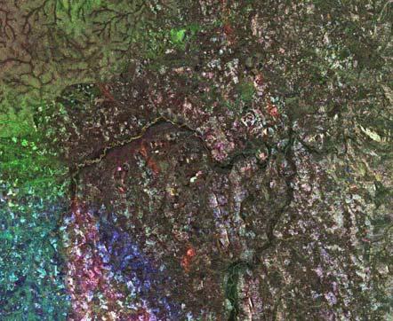
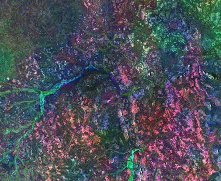
16 ALOS PALSAR Processing - Polarimetry JAXA JAXA Pauli Decomposition H/A/α Decomposition
17 SAR-Optical - Ruled based Decision Classifier Optical TUBE Spectral II meeting - 17 June 2002 Classes Optical Spectral- Temporal Classes low med low high med med low Multi-temporal SAR based Classes

18 SAR-Optical - Ruled based Decision Classifier - Example Optical Spectral Classes Multi-temporal temporal SAR data Final Product

19 Senegal Early Warning Product Coherence Mean Intensity Intensity Change ENVISAT ASAR Wide Swath, May-June

20 Senegal, Multi-temporal temporal Mosaic Multi-temporal ENVISAT ASAR Alternating Polarization mosaic with a spatial resolution of 15 metres. Note that the mosaicing procedure is completely automatic. May 2006 July 2006 August 2006


21 Senegal, 2005 Based on ENVISAT ASAR AP and Landsat TM

22 Senegal, 2005 Based on MERIS FR fapar

23 Malawi 2005/06 - Early Warning Product Sept-Oct 2005 Mar-Apr 2006 Coherence Mean Intensity Intensity Change ENVISAT ASAR Wide Swath


24 Malawi 2005/06 Based on ENVISAT ASAR AP and Landsat TM

25 Malawi 2005/06 - Extent of Cultivation + MODIS DMP ASAR WS Intensity

26 Zimbabwe 2006/07 - ENVISAT ASAR AP Planning Continuous acquisitions between October and June


27 Zimbabwe 2006/07 - LCM at country level derived from Landsat TM October - Spectral Classes April - Spectral Classes Thematic Classes
28 The ALOS PALSAR Role Temporal AND spatial resolution are key parameters to monitor vegetation changes. ALOS PALSAR data will be exploited in combination with ENVISAT ASAR AP and Landsat TM data, hence enabling to increase the temporal resolution to complement C-band data (in particular important after the initial vegetation growth) and optical data. The use of long-term L-band coherence (in Image and ScanSAR mode) will provide a significant additional information in land degraded areas.
29 Thank you for your Attention


30 On Earth displacement and ScanSAR. just for Shimada 200 km
SARscape Modules for ENVI
 Visual Information Solutions SARscape Modules for ENVI Read, process, analyze, and output products from SAR data. ENVI. Easy to Use Tools. Proven Functionality. Fast Results. DEM, based on TerraSAR-X-1
SARscape for ENVI. A Complete SAR Analysis Solution
 SARscape for ENVI A Complete SAR Analysis Solution IDL and ENVI A Foundation for SARscape IDL The Data Analysis & Visualization Platform Data Access: IDL supports virtually every data format, type and
GFOI Expert Workshop. Sensor interoperability, complementarity, and the temporal component. Francesco Holecz
 GFOI Expert Workshop Sensor interoperability, complementarity, and the temporal component Francesco Holecz Woods Hole Research Centre, MA, USA 10-11 June, 2014 On sensor interoperability Single-date vs.
SARscape 4.1 Supported Sensors/Products (October 2008)
") SARscape 4.1 Supported Sensors/Products (October 2008) ALOS PALSAR (provided by JAXA) In case of RAW (level 1.0) data, import is carried out within the Focusing Module. PALSAR RAW data in CEOS standard
SARscape 4.1 Supported Sensors/Products (October 2008) ALOS PALSAR (provided by JAXA) In case of RAW (level 1.0) data, import is carried out within the Focusing Module. PALSAR RAW data in CEOS standard
Earth Observation and Sensing Technologies: a focus on Radar Imaging Developments. Riccardo Lanari
 Earth Observation and Sensing Technologies: a focus on Radar Imaging Developments Riccardo Lanari Institute for Electromagnetic Sensing of the Environment (IREA) National Research Council of Italy (CNR)
Fringe 2015 Workshop
 Fringe 2015 Workshop On the Estimation and Interpretation of Sentinel-1 TOPS InSAR Coherence Urs Wegmüller, Maurizio Santoro, Charles Werner and Oliver Cartus Gamma Remote Sensing AG - S1 IWS InSAR and
All rights reserved. ENVI, IDL and Jagwire are trademarks of Exelis, Inc. All other marks are the property of their respective owners.
 SAR Analysis Made Easy with SARscape 5.1 All rights reserved. ENVI, IDL and Jagwire are trademarks of Exelis, Inc. All other marks are the property of their respective owners. 2014, Exelis Visual Information
TerraSAR-X Applications Guide
 TerraSAR-X Applications Guide Extract: Maritime Monitoring: Ship Detection April 2015 Airbus Defence and Space Geo-Intelligence Programme Line Maritime Monitoring: Ship Detection Issue Maritime security
RADAR INTERFEROMETRY FOR SAFE COAL MINING IN CHINA
 RADAR INTERFEROMETRY FOR SAFE COAL MINING IN CHINA L. Ge a, H.-C. Chang a, A. H. Ng b and C. Rizos a Cooperative Research Centre for Spatial Information School of Surveying & Spatial Information Systems,
European Space Agency and IPY
 European Space Agency and IPY ESA supports IPY 2007-2008 activities: First ESA step was a dedicated Announcement Opportunity (AO) for EO data provision in support IPY, released in 2006, with data provision
Review. Guoqing Sun Department of Geography, University of Maryland ABrief
 Review Guoqing Sun Department of Geography, University of Maryland gsun@glue.umd.edu ABrief Introduction Scattering Mechanisms and Radar Image Characteristics Data Availability Example of Applications
SAR Remote Sensing (Microwave Remote Sensing)
") iirs SAR Remote Sensing (Microwave Remote Sensing) Synthetic Aperture Radar Shashi Kumar shashi@iirs.gov.in Electromagnetic Radiation Electromagnetic radiation consists of an electrical field(e) which
iirs SAR Remote Sensing (Microwave Remote Sensing) Synthetic Aperture Radar Shashi Kumar shashi@iirs.gov.in Electromagnetic Radiation Electromagnetic radiation consists of an electrical field(e) which
ASAR Training Course, Hanoi, 25 February 7 March 2008 Introduction to Radar Interferometry
 Introduction to Radar Interferometry Presenter: F.Sarti (ESA/ESRIN) 1 Imaging Radar : reminder 2 Physics of radar Potentialities of radar All-weather observation system (active system) Penetration capabilities
TanDEM-X: Mission Status & Scientific Contribution
 TanDEM-X: Mission Status & Scientific Contribution Irena Hajnsek 1/2, Gerhard Krieger 1, Kostas Papathanassiou 1, Stefan Baumgartner 1, Marc Rodriguez-Cassola 1, Pau Prats 1, Maria Sanjuan Ferrer 1, Florian
RESERVOIR MONITORING USING RADAR SATELLITES
 RESERVOIR MONITORING USING RADAR SATELLITES Alain Arnaud, Johanna Granda, Geraint Cooksley ALTAMIRA INFORMATION S.L., Calle Córcega 381-387, E-08037 Barcelona, Spain. Key words: Reservoir monitoring, InSAR,
TerraSAR-X Applications Guide
 TerraSAR-X Applications Guide Extract: Change Detection and Monitoring: Geospatial / Image Intelligence April 2015 Airbus Defence and Space Geo-Intelligence Programme Line Change Detection and Monitoring:
HIGH RESOLUTION DIFFERENTIAL INTERFEROMETRY USING TIME SERIES OF ERS AND ENVISAT SAR DATA
 HIGH RESOLUTION DIFFERENTIAL INTERFEROMETRY USING TIME SERIES OF ERS AND ENVISAT SAR DATA Javier Duro 1, Josep Closa 1, Erlinda Biescas 2, Michele Crosetto 2, Alain Arnaud 1 1 Altamira Information C/ Roger
MULTI-CHANNEL SAR EXPERIMENTS FROM THE SPACE AND FROM GROUND: POTENTIAL EVOLUTION OF PRESENT GENERATION SPACEBORNE SAR
 3 nd International Workshop on Science and Applications of SAR Polarimetry and Polarimetric Interferometry POLinSAR 2007 January 25, 2007 ESA/ESRIN Frascati, Italy MULTI-CHANNEL SAR EXPERIMENTS FROM THE
Radar remote sensing from space for monitoring deformations affecting urban areas and infrastructures
 Radar remote sensing from space for monitoring deformations affecting urban areas and infrastructures Riccardo Lanari IREA-CNR Napoli EGU2014, Vienna 30 April, 2014 Why Radar (SAR) Imaging from space?
Introduction to radar. interferometry
 Introduction to radar Introduction to Radar Interferometry interferometry Presenter: F.Sarti (ESA/ESRIN) With kind contribution by the Radar Department of CNES All-weather observation system (active system)
SENTINEL-1 Toolbox. Polarimetric Tutorial Issued March 2015 Updated August Luis Veci
 SENTINEL-1 Toolbox Polarimetric Tutorial Issued March 2015 Updated August 2016 Luis Veci Copyright 2015 Array Systems Computing Inc. http://www.array.ca/ http://step.esa.int Polarimetric Tutorial The goal
PALSAR SCANSAR SCANSAR Interferometry
 PALSAR SCANSAR SCANSAR Interferometry Masanobu Shimada Japan Aerospace Exploration Agency Earth Observation Research Center ALOS PI symposium, Greece Nov. 6 2008 1 Introduction L-band PALSAR strip mode
remote sensing? What are the remote sensing principles behind these Definition
 Introduction to remote sensing: Content (1/2) Definition: photogrammetry and remote sensing (PRS) Radiation sources: solar radiation (passive optical RS) earth emission (passive microwave or thermal infrared
Damage detection in the 2015 Nepal earthquake using ALOS-2 satellite SAR imagery
 Proceedings of the Tenth Pacific Conference on Earthquake Engineering Building an Earthquake-Resilient Pacific 6-8 November 2015, Sydney, Australia Damage detection in the 2015 Nepal earthquake using ALOS-2
MULTIPLE APERTURE INSAR (MAI) WITH C-BAND AND L-BAND DATA: NOISE AND PRECISION
 WITH C-BAND AND L-BAND DATA: NOISE AND PRECISION") MULTIPLE APERTURE INSAR (MAI) WITH C-BAND AND L-BAND DATA: NOISE AND PRECISION Noa Bechor Ben-Dov and Thomas A. Herring Massachusetts Institute of Technology, Cambridge, MA 2139, USA, Email: nbechor@chandler.mit.edu
MULTIPLE APERTURE INSAR (MAI) WITH C-BAND AND L-BAND DATA: NOISE AND PRECISION Noa Bechor Ben-Dov and Thomas A. Herring Massachusetts Institute of Technology, Cambridge, MA 2139, USA, Email: nbechor@chandler.mit.edu
ASAR, MERIS and AATSR products
 ASAR, MERIS and AATSR products Francesco Sarti and Steffen Dransfeld ESA/ESRIN 25 February 2008 ENVISAT http://envisat.esa.int/ Launched in 2002. Sun-synchronous polar orbit (SSO): Nominal reference orbit
Data acquisition and access for the Congo Basin
 MRV Joint Workshop 22-24 June 2010, Guadalajara, Jalisco Mexico Data acquisition and access for the Congo Basin Landing Mané 1, Michael Brady 2, Chris Justice 3 and Alice Altstatt 3 1) Satellite Observatory
RADAR REMOTE SENSING
 RADAR REMOTE SENSING Jan G.P.W. Clevers & Steven M. de Jong Chapter 8 of L&K 1 Wave theory for the EMS: Section 1.2 of L&K E = electrical field M = magnetic field c = speed of light : propagation direction
Index 275. K Ka-band, 250, 259 Knowledge-based concepts, 110
 Index A Acquisition planning, 225 Across-track, 30, 41, 88, 90 93 Across-track interferometry, 30 Along-track, 3, 10, 19, 41, 88, 90, 91, 93, 94, 103 Along-track interferometry, 41 Ambiguous elevation
IMPACT OF BAQ LEVEL ON INSAR PERFORMANCE OF RADARSAT-2 EXTENDED SWATH BEAM MODES
 IMPACT OF BAQ LEVEL ON INSAR PERFORMANCE OF RADARSAT-2 EXTENDED SWATH BEAM MODES Jayson Eppler (1), Mike Kubanski (1) (1) MDA Systems Ltd., 13800 Commerce Parkway, Richmond, British Columbia, Canada, V6V
Introduction to PolSARpro v3.0
 Introduction to PolSARpro v3.0 Eric POTTIER Tuesday 4 September, Lecture D2PA-2 & D2PB-1 04/09/07 Lecture D2PA-2 & D2PB-1 Introduction to PolSARpro v3.0 Eric POTTIER 1 General Presentation of PolSARpro
Synthetic Aperture Radar Interferometry (InSAR) Technique (Lecture I- Tuesday 11 May 2010)
 Technique (Lecture I- Tuesday 11 May 2010)") Synthetic Aperture Radar Interferometry () Technique (Lecture I- Tuesday 11 May 2010) ISNET/CRTEAN Training Course on Synthetic Aperture Radar (SAR) Imagery: Processing, Interpretation and Applications
Synthetic Aperture Radar Interferometry () Technique (Lecture I- Tuesday 11 May 2010) ISNET/CRTEAN Training Course on Synthetic Aperture Radar (SAR) Imagery: Processing, Interpretation and Applications
Envisat and ERS missions: data and services
 FRINGE 2005 Workshop Envisat and ERS missions: and services Henri LAUR Envisat Mission Manager Our top objective: ease access to Earth Observation Common objective for all missions handled by ESA: Envisat,
Introduction to Remote Sensing
 Introduction to Remote Sensing Spatial, spectral, temporal resolutions Image display alternatives Vegetation Indices Image classifications Image change detections Accuracy assessment Satellites & Air-Photos
Synthetic Aperture Radar for Rapid Flood Extent Mapping
 National Aeronautics and Space Administration ARSET Applied Remote Sensing Training http://arset.gsfc.nasa.gov @NASAARSET Synthetic Aperture Radar for Rapid Flood Extent Mapping Sang-Ho Yun ARIA Team Jet
Cristina M. Surdu 1, Claude R. Duguay 2 and Diego Fernández Prieto 1
 Cristina M. Surdu 1, Claude R. Duguay 2 and Diego Fernández Prieto 1 1 European Space Agency, ESRIN, Italy 2 University of Waterloo, Ontario, Canada Objectives To document and analyze the response of High
Principles of Remote Sensing. Shuttle Radar Topography Mission S R T M. Michiel Damen. Dept. Earth Systems Analysis
 Principles of Remote Sensing Shuttle Radar Topography Mission S R T M Michiel Damen Dept. Earth Systems Analysis Contents Present problems with DEMs Advantage of SRTM Cell size Mission and system Radar
RADARSAT-2 Program Update Daniel De Lisle Canadian Space Agency
 RADARSAT-2 Program Update Daniel De Lisle Canadian Space Agency Presentation outline RADARSAT-1 Update RADARSAT-2 Mission description Mission Objectives System Characteristics Data Commercialization/Allocation
Specificities of Near Nadir Ka-band Interferometric SAR Imagery
 Specificities of Near Nadir Ka-band Interferometric SAR Imagery Roger Fjørtoft, Alain Mallet, Nadine Pourthie, Jean-Marc Gaudin, Christine Lion Centre National d Etudes Spatiales (CNES), France Fifamé
AGRICULTURE LAND USE MAPPING USING MULTI-SENSOR AND MULTI- TEMPORAL EARTH OBSERVATION DATA INTRODUCTION
 AGRICULTURE LAND USE MAPPING USING MULTI-SENSOR AND MULTI- TEMPORAL EARTH OBSERVATION DATA Jiali Shang Catherine Champagne Heather McNairn Agriculture and Agri-Food Canada 960 Carling Avenue, Ottawa, ON,
Spectral coherence applied to vessel tracking
 Spectral coherence applied to vessel tracking Christian Barbier (cbarbier@ulg.ac.be) Dominique Derauw (dderauw@ulg.ac.be) Centre Spatial de Liège 2 Wide-band potential Recent sensors use wide band signals
Global 25 m Resolution PALSAR-2/PALSAR Mosaic. and Forest/Non-Forest Map (FNF) Dataset Description
 Dataset Description") Global 25 m Resolution PALSAR-2/PALSAR Mosaic and Forest/Non-Forest Map (FNF) Dataset Description Japan Aerospace Exploration Agency (JAXA) Earth Observation Research Center (EORC) 1 Revision history Version
Global 25 m Resolution PALSAR-2/PALSAR Mosaic and Forest/Non-Forest Map (FNF) Dataset Description Japan Aerospace Exploration Agency (JAXA) Earth Observation Research Center (EORC) 1 Revision history Version
SAR Remote Sensing. Introduction into SAR. Data characteristics, challenges, and applications.
 SAR Remote Sensing Introduction into SAR. Data characteristics, challenges, and applications. PD Dr. habil. Christian Thiel, Friedrich-Schiller-University Jena DLR-HR Jena & Friedrich-Schiller-University
XSAT Ground Segment at CRISP
 XSAT Ground Segment at CRISP LIEW Soo Chin Head of Research, CRISP http://www.crisp.nus.edu.sg 5 th JPTM for Sentinel Asia Step-2, 14-16 Nov 2012, Daejeon, Korea Centre for Remote Imaging, Sensing and
Global 25 m Resolution PALSAR-2/PALSAR Mosaic. and Forest/Non-Forest Map (FNF) Dataset Description
 Dataset Description") Global 25 m Resolution PALSAR-2/PALSAR Mosaic and Forest/Non-Forest Map (FNF) Dataset Description Japan Aerospace Exploration Agency (JAXA) Earth Observation Research Center (EORC) 1 Revision history Version
Global 25 m Resolution PALSAR-2/PALSAR Mosaic and Forest/Non-Forest Map (FNF) Dataset Description Japan Aerospace Exploration Agency (JAXA) Earth Observation Research Center (EORC) 1 Revision history Version
APCAS/10/21 April 2010 ASIA AND PACIFIC COMMISSION ON AGRICULTURAL STATISTICS TWENTY-THIRD SESSION. Siem Reap, Cambodia, April 2010
 APCAS/10/21 April 2010 Agenda Item 8 ASIA AND PACIFIC COMMISSION ON AGRICULTURAL STATISTICS TWENTY-THIRD SESSION Siem Reap, Cambodia, 26-30 April 2010 The Use of Remote Sensing for Area Estimation by Robert
Affordable space based radar for homeland security
 Changing the economics of space Affordable space based radar for homeland security Adam Baker Brent Abbott Phil Whittaker Rachel Bird Luis Gomes Summary Why Radar? However: Radar data is expensive Users
The Radar Ortho Suite is an add-on to Geomatica. It requires Geomatica Core or Geomatica Prime as a pre-requisite.
 Technical Specifications Radar Ortho Suite The Radar Ortho Suite includes rigorous and rational function models developed to compensate for distortions and produce orthorectified radar images. Distortions
PROGRESS IN ADDRESSING SCIENCE GOALS FOR GLACIER OBSERVATIONS BY MEANS OF SAR. Frank Paul & Thomas Nagler
 PROGRESS IN ADDRESSING SCIENCE GOALS FOR GLACIER OBSERVATIONS BY MEANS OF SAR Frank Paul & Thomas Nagler SAR Coordination Working Group Meeting, 13/11/2016 Observed glacier products and sensors Product
SAR missions for oceanography at the European Space Agency
 SAR missions for oceanography at the European Space Agency ERS-1, ERS-2, Envisat, Sentinel-1A, Sentinel-1B, ESA 3 rd Party Missions (ALOS) Prepared by ESA teams and ESA supporting companies ESA and SAR
Urban tunneling and the advantages of using InSAR SPN satellite technology to detect and monitor surface deformation effects
 Urban tunneling and the advantages of using InSAR SPN satellite technology to detect and monitor surface deformation effects María de Faragó 1, Geraint Cooksley 1 1 Altamira Information, Spain ABSTRACT
ACTIVE SENSORS RADAR
 ACTIVE SENSORS RADAR RADAR LiDAR: Light Detection And Ranging RADAR: RAdio Detection And Ranging SONAR: SOund Navigation And Ranging Used to image the ocean floor (produce bathymetic maps) and detect objects
 Performance Comparison between Dual Polarimetric and Fully Polarimetric data for DInSAR Subsidence monitoring Dani Monells, Jordi J. Mallorquí Universitat Politècnica de Catalunya, Departament de Teoria
Environmental Impact Assessment of Mining Subsidence by Using Spaceborne Radar Interferometry
 Environmental Impact Assessment of Mining Subsidence by Using Spaceborne Radar Interferometry Hsing-Chung CHANG, Linlin GE and Chris RIZOS, Australia Key words: Mining Subsidence, InSAR, DInSAR, DEM. SUMMARY
ACTIVE MICROWAVE REMOTE SENSING OF LAND SURFACE HYDROLOGY
 Basics, methods & applications ACTIVE MICROWAVE REMOTE SENSING OF LAND SURFACE HYDROLOGY Annett.Bartsch@polarresearch.at Active microwave remote sensing of land surface hydrology Landsurface hydrology:
Monitoring of railroad infrastructure with the use of differential interferometric techniques of SAR data processing
 A.S.Vasileisky, R.I.Shuvalov Monitoring of railroad infrastructure with the use of differential interferometric techniques of SAR data processing From Imagery to Map Digital Photogrammetric Technologies
TerraSAR-X and TanDEM-X: Revolution in Spaceborne Radar
 TerraSAR-X and TanDEM-X: Revolution in Spaceborne Radar Ralf Düring, Fifamè N. Koudogbo, and Marco Weber, Infoterra GmbH, 88039 Friedrichshafen, Germany INTRODUCTION While Earth Observation from space
Analysis and interpretation of tsunami damage caused by the 2011 Japan earthquake using ENVISAT ASAR images
 IOP Conference Series: Earth and Environmental Science OPEN ACCESS Analysis and interpretation of tsunami damage caused by the 2011 Japan earthquake using ENVISAT ASAR images To cite this article: Yanmei
Observing Dry-Fallen Intertidal Flats in the German Bight Using ALOS PALSAR Together With Other Remote Sensing Sensors
 Observing Dry-Fallen Intertidal Flats in the German Bight Using ALOS PALSAR Together With Other Remote Sensing Sensors Martin Gade, Institut für Meereskunde & Kerstin Stelzer Brockmann Consult Outline
Developing land cover products in Monsoon Asia through integration of Landsat (GLS2005) and L-band PALSAR imagery: --- An Update
 and L-band PALSAR imagery: --- An Update") Developing land cover products in Monsoon Asia through integration of Landsat (GLS2005) and L-band PALSAR imagery: --- An Update Landsat 7 ETM+ PALSAR Xiangming Xiao Center for Spatial Analysis, University
Developing land cover products in Monsoon Asia through integration of Landsat (GLS2005) and L-band PALSAR imagery: --- An Update Landsat 7 ETM+ PALSAR Xiangming Xiao Center for Spatial Analysis, University
EE 529 Remote Sensing Techniques. Introduction
 EE 529 Remote Sensing Techniques Introduction Course Contents Radar Imaging Sensors Imaging Sensors Imaging Algorithms Imaging Algorithms Course Contents (Cont( Cont d) Simulated Raw Data y r Processing
Biomass, a polarimetric interferometric P-band SAR mission
 Biomass, a polarimetric interferometric P-band SAR mission M. Arcioni, P. Bensi, M. Fehringer, F. Fois, F. Heliere, N. Miranda, K. Scipal Fringe 2015, ESRIN 27/03/2015 The Biomass Mission 1. Biomass was
9/12/2011. Training Course Remote Sensing Basic Theory & Image Processing Methods September 2011
 Training Course Remote Sensing Basic Theory & Image Processing Methods 19 23 September 2011 Popular Remote Sensing Sensors & their Selection Michiel Damen (September 2011) damen@itc.nl 1 Overview Low resolution
Microwave remote sensing. Rudi Gens Alaska Satellite Facility Remote Sensing Support Center
 Microwave remote sensing Alaska Satellite Facility Remote Sensing Support Center 1 Remote Sensing Fundamental The entire range of EM radiation constitute the EM Spectrum SAR sensors sense electromagnetic
TerraSAR-X Image Product Guide
 [Texte] TerraSAR-X Image Product Guide Page 1 of 24 Ref.: OP00xxxxxxxxxx Commercial in Confidence 1 Introduction TerraSAR-X and TanDEM-X are commercial German Synthetic Aperture Radar (SAR) Earth observation
SAR Multi-Temporal Applications
 SAR Multi-Temporal Applications 83230359-DOC-TAS-EN-001 Contents 2 Advantages of SAR Remote Sensing Technology All weather any time Frequencies and polarisations Interferometry and 3D mapping Change Detection
Nazemeh Ashrafianfar, Hans-Peter Hebel and Wolfgang Busch
 MONITORING OF MINING INDUCED LAND SUBSIDENCE - DIFFERENTIAL SAR INTERFEROMETRY AND PERSISTENT SCATTERER INTERFEROMETRY USING TERRASAR-X DATA IN COMPARISON WITH ENVISAT DATA ABSTRACT Nazemeh Ashrafianfar,
Comparison between SAR atmospheric phase screens at 30 by means of ERS and ENVISAT data
 Fringe 2007 - ESA-ESRIN - Frascati, November 28, 2007 Comparison between SAR atmospheric phase screens at 30 by means of ERS and ENVISAT data D. Perissin Politecnico di Milano Tele-Rilevamento Europa -
Session I: Status Reports on Ongoing and Future Missions Chairs: M.Shimada (JAXA) and P. Snoeij (ESA)
 and P. Snoeij (ESA)") Session I: Status Reports on Ongoing and Future Missions Chairs: M.Shimada (JAXA) and P. Snoeij (ESA) Canadian Radarsat Mission status-s. Cote Operating far beyond design lifetime (RSAT-1: 16 years, ASAR:
Session I: Status Reports on Ongoing and Future Missions Chairs: M.Shimada (JAXA) and P. Snoeij (ESA) Canadian Radarsat Mission status-s. Cote Operating far beyond design lifetime (RSAT-1: 16 years, ASAR:
Image interpretation. Aliens create Indian Head with an ipod? Badlands Guardian (CBC) This feature can be found 300 KMs SE of Calgary.
 This feature can be found 300 KMs SE of Calgary.") Image interpretation Aliens create Indian Head with an ipod? Badlands Guardian (CBC) This feature can be found 300 KMs SE of Calgary. 50 1 N 110 7 W Milestones in the History of Remote Sensing 19 th century
Image interpretation Aliens create Indian Head with an ipod? Badlands Guardian (CBC) This feature can be found 300 KMs SE of Calgary. 50 1 N 110 7 W Milestones in the History of Remote Sensing 19 th century
The TerraSAR-L System and Mission Objectives
 The TerraSAR-L System and Mission Objectives Manfred Zink & Ramon Torres TerraSAR Project, ESA-ESTEC Keplerlaan 1, 2200 AG, Noordwijk, The Netherlands Tel: +31 71565 3038, Fax: +31 71565 3191, Email: Manfred.Zink@esa.int
COMPARATIVE ANALYSIS OF INSAR DIGITAL SURFACE MODELS FOR TEST AREA BUCHAREST
 COMPARATIVE ANALYSIS OF INSAR DIGITAL SURFACE MODELS FOR TEST AREA BUCHAREST Iulia Dana (1), Valentin Poncos (2), Delia Teleaga (2) (1) Romanian Space Agency, 21-25 Mendeleev Street, 010362, Bucharest,
Sentinel-1 System Overview
 Sentinel-1 System Overview Dirk Geudtner, Rámon Torres, Paul Snoeij, Malcolm Davidson European Space Agency, ESTEC Global Monitoring for Environment and Security (GMES) EU-led program aiming at providing
Development of a Ground-based Synthetic Aperture Radar System for Highly Repeatable Measurements
 Development of a Ground-based Synthetic Aperture Radar System for Highly Repeatable Measurements Hoonyol LEE, Seong-Jun CHO, Nak-Hoon SUNG and Jung-Ho KIM Department of Geophysics, Kangwon National University
ASAR acquisition strategy for IPY -Update-
 ASAR acquisition strategy for IPY -Update- Jorge Del Rio Vera Henri Laur Presentation contents: 1. Background 2. ASAR Acquisition strategy update Tandem Campaign ICESat support campaign Wilkins Iceshelf
Multiscale Monitoring and Health Assessment for Effective Management of Flood-Control Infrastructure Systems
 Multiscale Monitoring and Health Assessment for Effective Management of Flood-Control Infrastructure Systems Tarek Abdoun Rensselaer Polytechnic Institute Levees Everywhere 3 Vision SAR Satellite 4 SAR
Detecting and Mapping Invasive Phragmites australis in the Coastal Great Lakes with ALOS PALSAR Imagery
 Detecting and Mapping Invasive Phragmites australis in the Coastal Great Lakes with ALOS PALSAR Imagery Brian Huberty U.S Fish & Wildlife Service Region 3 Ecological Services Laura L. Bourgeau-Chavez,
UNOSAT Satellite Imagery and GIS Solutions for DRR and Emergency Management
 UNOSAT Satellite Imagery and GIS Solutions for DRR and Emergency Management Francesco Pisano Director, Research, Technology Applications & Knowledge Systems January 2013 Introduction to UNOSAT 2 About
Application of Satellite Remote Sensing for Natural Disasters Observation
 Application of Satellite Remote Sensing for Natural Disasters Observation Prof. Krištof Oštir, Ph.D. University of Ljubljana Faculty of Civil and Geodetic Engineering Outline Earth observation current
Figure 1: C band and L band (SIR-C/X-SAR images of Flevoland in Holland). color scheme: HH: red, HV:green, VV: blue
. color scheme: HH: red, HV:green, VV: blue") L-band PS analysis: JERS-1 results and TerraSAR L predictions Kenji Daito (1), Alessandro Ferretti (), Shigeki Kuzuoka (3),Fabrizio Novali (), Pietro Panzeri (), Fabio Rocca (4) (1) Daido Institute of
L-band PS analysis: JERS-1 results and TerraSAR L predictions Kenji Daito (1), Alessandro Ferretti (), Shigeki Kuzuoka (3),Fabrizio Novali (), Pietro Panzeri (), Fabio Rocca (4) (1) Daido Institute of
The TerraSAR-L Interferometric Mission Objectives
 The TerraSAR-L Interferometric Mission Objectives Manfred Zink TerraSAR Project, ESA-ESTEC Keplerlaan 1, 2200 AG, Noordwijk, The Netherlands Tel: +31 71565 3038, Fax: +31 71565 3191, Email: Manfred.Zink@esa.int
Copernicus Introduction Lisbon, Portugal 13 th & 14 th February 2014
 Copernicus Introduction Lisbon, Portugal 13 th & 14 th February 2014 Contents Introduction GMES Copernicus Six thematic areas Infrastructure Space data An introduction to Remote Sensing In-situ data Applications
Introduction to Microwave Remote Sensing
 Introduction to Microwave Remote Sensing lain H. Woodhouse The University of Edinburgh Scotland Taylor & Francis Taylor & Francis Group Boca Raton London New York A CRC title, part of the Taylor & Francis
SAR Interferometry Capabilities of Canada's planned SAR Satellite Constellation
 SAR Interferometry Capabilities of Canada's planned SAR Satellite Constellation Dirk Geudtner, Guy Séguin,, Ralph Girard Canadian Space Agency RADARSAT Follow-on Program CSA is in the middle of a Phase
Canadian Space Agency Contribution to STG
 Canadian Space Agency Contribution to STG Canadian Space Agency 1 STG5 Geneva, Nov 30 to Dec 2, 2009 2 Canadian Space Agency ASAP Portefolio: Name Frozen Baseline Sea Ice Min and Max Snapshots Fine Image
Satellite Imagery Characteristics, Uses and Delivery to GIS Systems. Wayne Middleton April 2014
 Satellite Imagery Characteristics, Uses and Delivery to GIS Systems Wayne Middleton April 2014 About Geoimage Founded in Brisbane 1988 Leading Independent company Specialists in satellite imagery and geospatial
PROGRESS IN ADDRESSING SCIENCE GOALS FOR GLACIER OBSERVATIONS BY MEANS OF SAR
 PROGRESS IN ADDRESSING SCIENCE GOALS FOR GLACIER OBSERVATIONS BY MEANS OF SAR Frank Paul, Thomas Nagler, Dana Floricioiu, et al. PSTG, 13/9/2016 Panmah, Karakoram Observed glacier products and sensors
Aquarius/SAC-D and Soil Moisture
 Aquarius/SAC-D and Soil Moisture T. J. Jackson P. O Neill February 24, 2011 Aquarius/SAC-D and Soil Moisture + L-band dual polarization + Combined active and passive Coarse spatial resolution (~100 km)
Application and potentials of RADAR and LiDAR technologies for forest carbon assessment in Pacific Island Countries
 Application and potentials of RADAR and LiDAR technologies for forest carbon assessment in Pacific Island Countries June 19th, 2012 PNGFA-JICA Workshop Masamichi HARAGUCHI (Kokusai Kogyo Co., Ltd.) Consultant
DLR contribution and perspectives for JECAM
 DLR contribution and perspectives for JECAM Dr. Helmut Staudenrausch 1, Dr. Achim Roth 2 1 DLR Space Administration, Earth Observations helmut.staudenrausch@dlr.de 2 DLR, German Remote Sensing Data Center
So S ft f w t a w re T o T ol Po P ls l A S Rpro v5.0. E. E. Po P ttie i r E.Pottier (2013)
") Software Tool PolSARprov5.0 E. Pottier The Polarimetric Polarimetric SAR Data Pro Processing cessing and Educational Tool v5.0 AIRSAR SETHI DCRS PISAR ESAR EMISAR UAV-SAR FSAR CONVAIR PolSARpro v5.0 Software
Software Tool PolSARprov5.0 E. Pottier The Polarimetric Polarimetric SAR Data Pro Processing cessing and Educational Tool v5.0 AIRSAR SETHI DCRS PISAR ESAR EMISAR UAV-SAR FSAR CONVAIR PolSARpro v5.0 Software
Towards Sentinel-1 Soil Moisture Data Services: The Approach taken by the Earth Observation Data Centre for Water Resources Monitoring
 Towards Sentinel-1 Soil Moisture Data Services: The Approach taken by the Earth Observation Data Centre for Water Resources Monitoring Wolfgang Wagner wolfgang.wagner@geo.tuwien.ac.at Department of Geodesy
MERIS instrument. Muriel Simon, Serco c/o ESA
 MERIS instrument Muriel Simon, Serco c/o ESA Workshop on Sustainable Development in Mountain Areas of Andean Countries Mendoza, Argentina, 26-30 November 2007 ENVISAT MISSION 2 Mission Chlorophyll case
Sources of Geographic Information
 Sources of Geographic Information Data properties: Spatial data, i.e. data that are associated with geographic locations Data format: digital (analog data for traditional paper maps) Data Inputs: sampled
ALOS-Indonesia POLinSAR Experiment (AIPEX): First Result*
: First Result*") ALOS-Indonesia POLinSAR Experiment (AIPEX): First Result* Mahmud Raimadoya(1), Ludmila Zakharova(2), Bambang Trisasongko(1), Nurwadjedi(3) (1) Bogor Agricultural University (IPB), P.O. Box 2049, Bogor
ALOS-Indonesia POLinSAR Experiment (AIPEX): First Result* Mahmud Raimadoya(1), Ludmila Zakharova(2), Bambang Trisasongko(1), Nurwadjedi(3) (1) Bogor Agricultural University (IPB), P.O. Box 2049, Bogor
The Current Status and Brief Results of Engineering Model for PALSAR-2 onboard ALOS-2 and Science Project
 The Current Status and Brief Results of Engineering Model for PALSAR-2 onboard ALOS-2 and Science Project + The 16 th KC meeting Japan Aerospace Exploration Agency Masanobu Shimada, Yukihiro KANKAKU The
How accurately can current and futureinsar missions map tectonic strain?
 How accurately can current and futureinsar missions map tectonic strain? Outline: How accurately do we need to measure strain? InSAR missions Error budget for InSAR Ability of current, planned and proposed
SARscape s Coherent Changes Detection Tutorial
 SARscape s Coherent Changes Detection Tutorial Version 1.0 April 2018 1 Index Introduction... 3 Setting Preferences... 4 Data preparation... 5 Input data... 5 DEM Extraction... 5 Single Panels processing...
Application Potential of Planned SAR Satellites a Preview
 PREPRINT/PRÉTIRAGE Application Potential of Planned SAR Satellites a Preview J.J. van der Sanden 1, P. Budkewitsch 1, R. Landry 1, M.J. Manore 2, H. McNairn 1, T.J. Pultz 1, and P.W. Vachon 1 1 Canada
Forest Resources Assessment using Synthe c Aperture Radar
 Forest Resources Assessment using Synthe c Aperture Radar Project Background F RA-SAR 2010 was initiated to support the Forest Resources Assessment (FRA) of the United Nations Food and Agriculture Organization