Monitoring of railroad infrastructure with the use of differential interferometric techniques of SAR data processing
|
|
|
- Branden Cooper
- 5 years ago
- Views:
Transcription

1 A.S.Vasileisky, R.I.Shuvalov Monitoring of railroad infrastructure with the use of differential interferometric techniques of SAR data processing From Imagery to Map Digital Photogrammetric Technologies

2 JSC «NIIAS» is the affiliated company of the JSC Russian Railroads responsible for application of space technologies: satellite navigation systems; Earth remote sensing; satellite telecommunication systems. Provides the common scientific and technical strategy and coordinates activities of the JSC Russian Railways subdivisions, branches, private institutes, affiliated and related organizations in the field of space technologies application in the railway transport. Space Technology Application Center of NIIAS was founded in 2008.


3 Satellite monitoring for the railroad transport Before explosion Quick-Bird, 0,6 m After explosion Quick-Bird, 0,6 m Benefits of ERS data Unbiased objective data Operative imaging Metric measurements Clear visual representation Broad swath of survey High information content (different spectral bands) High detailed Relatively low cost Digital representation Possibility for direct integration with GIS systems Observation of the effect of explosion at railroad station in Korea by optical remote sensing system


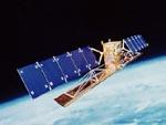
4 Progress in satellite radar Earth remote sensing sistems ERS-2 C, 30m, VV ENVISAT С, m, HH,VV,HV,VH Deployment of multi-satellite SAR systems started Huge archives of SAR data, experience of processing and application are collected RADARSAT-1 C, 8-100m, HH Spatial resolution of SAR imagery became equal to optical ERS data Modern SAR systems may change by request imaging mode (polarization combination, spatial resolution) ALOS L, 7-100m, HH,VV,HV,VH RADARSAT-2 C, 3-100м, HH,VV,HV,VH COSMO-SkyMed X, 1-100m, HH,VV,HV,VH TerraSAR-X X, 1-16m, HH,VV,HV,VH
 Independence from cloud coverage Presence of both amplitude and phase information makes it possible")
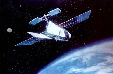
5 Features of data, collected by satellite radar remote sensing systems Diagram of active imaging of the Earth surface by satellite radar with synthetic aperture Benefits of data, collected by satellite radar remote sensing systems Independence form the illumination conditions (day or night) Independence from cloud coverage Presence of both amplitude and phase information makes it possible DEM generation and direct accurate estimation of shifts of the ground surface Capability of imaging in different polarization combinations Possibility to select spatial resolution by demand Broad swath


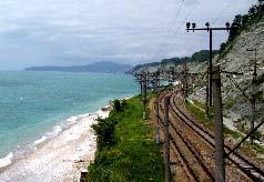
6 Capability of the radar data application for railroad transport system TerraSAR-X, 1 m Quick-Bird, 0,6 m Spatial resolution of the modern SAR satellite systems TerraSAR-X and COSMO-SkyMed is compatible with the resolution provided by traditional optical Earth remote sensing systems. Railroad tracks, trains, locomotives and infrastructure objects are excellent reflectors of radar signal and are stable recognized at SAR images.
7 Areas of SAR data application for railway transport system Benefits of SAR data Independence of image quality form illumination conditions and cloud coverage Presence of both amplitude and phase information DEM generation and direct estimation of the ground surface displacements with high accuracy Operative imaging of areas affected by emergency cases and disasters for evaluation of damage and work out correct means to minimize consequences Direct generation of precise digital terrain models (DTM) and digital elevation models (DEM) Accurate estimation of the ground surface displacements for detection of potentially dangerous railroad parts and for monitoring of natural and artificial impacts on the railway infrastructure: - monitoring of railroad lines in karst areas; - monitoring of railroad lines affected by landslides, rockfalls, slip erosion; - monitoring of railroad lines in permafrost areas.

8 Evaluation of emergency cases and disaster effect on railway transport objects Example of flooding observation and evaluation of caused damages by SAR data


9 Monotoring of karst areas Berezniaki, July 2007 Karst downfall resulted by accident at potash mine lead to destruction of the railroad infrastructure objects


10 Мonitoring of karst areas Evolution of downfall in Berezniaki Август 2007 г. Size of cone - 50х70х15 m track subsidence - 44 mm January 2008 Size of cone - 337х202 m complete destruction of the railroad track and infrastructure objects


11 Monitoring of karst processes in Dzershinsk area Influence of karst events on railroad track and infrastructure objects near Dzerzhinsk town February 1995 railroad track subsidence at Seima-Zholnono February 2007 karst cone formation with the 18 m diameter at Dzerzhinsk- Igumnovo track 2007 downfalls of ground surface near Kalininskaya station, sink lakes formation, river Chernaya disappear

12 Monitoring of karst processes in Dzerzhynsk area SAR imagery of the Dzerzhinsk town area obtained by TerraSAR-X in 2008 and acceptable for differential inteferometric processing , StripMap, VV, 3 m , StripMap, VV, 3 m , StripMap, VV, 3 m , StripMap, VV, 3 m , StripMap, VV, 3 m , StripMap, VV, 3 m , StripMap, VV, 3 m


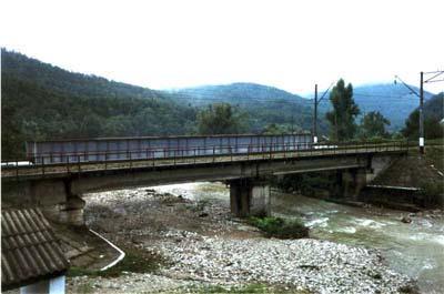
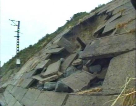
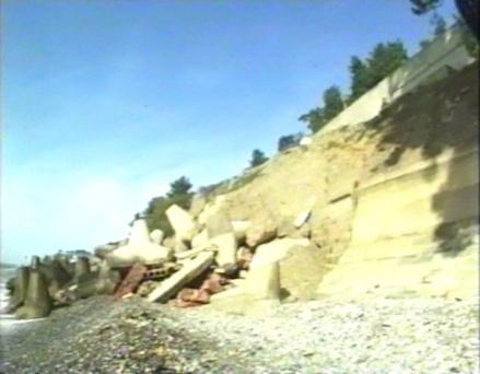
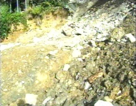
13 Monitoring of termokarst events, landslides, railroad track downfalls Deformation of bridge at Norilskaya river Destruction of railroad track and roadbed caused by landslide process as a result of drainage damage Torrent attack the railway track Tuapse-Adler Deformation of railroad Kharp-Labytnangi caused by cryogenic processes


14 Monitoring of cryogenic processes influence on railway infrastructure Shimanovskaya Derail of train: - 13 carriages derailed, - 60 passengers affected - 5 passengers hospitalized Seletkan


15 Pilot project of railroad monitoring Tuapse-Adler Analysis of archive SAR data: ERS-1/2, 10 past years WebGIS Displacement Evolution Mean Velocity


16 Technology of monitoring of potentially dangerous railroad tracks SAR data Detection of the ground surface displacements map of the ground surface displacements optical images railroad events information map of railroad infrastructure Detection of potentially dangerous impacts Collection and processing of coordinate and supplement information on the railroad infrastructure map of potentially dangerous influences objects GIS-system with the limited access through the internal network Maintenance and reparation instructions Traffic limitation instructions

17 Характеристика участка Туапсе-Адлер Северо-Кавказской ж.д. В 2007 году международным олимпийским комитетом г.сочи был выбран столицей зимних Олимпийских Игр 2014 г. Основные транспортные потоки, связанные со строительством олимпийских объектов пройдут по участку Туапсе-Адлер Северо-Кавказской ж.д.


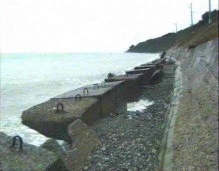
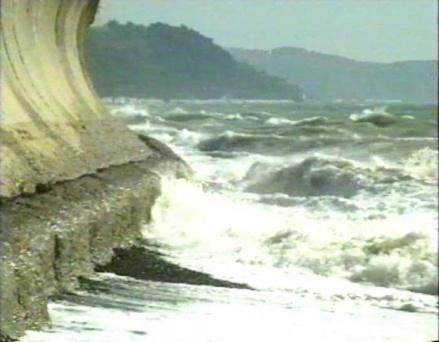
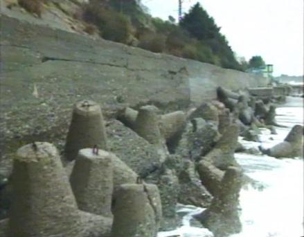
18 Dangerous natural influences at Tuapse-Adler railroad


19 Results of Tuapse-Adler railroad inspection Database of impacts of natural processes caused damage of the railway infrastructure objects for the last 50 years. Map of potentially dangerous natural and artificial impacts on railway infrastructure From Imagery to objects. Map Digital Photogrammetric Technologies


20 Detection of potentially-dangerous processes and events Thematic interpretation of optical imagery. Recognition of potentially dangerous for railroad lines natural and artificial processes and impacts Quick-Bird, 0,6 m

21 Map of potentially-dangerous natural and artificial processes


22 Retrospective analysis of SAR data - selection of characteristic features of dangerous events ENVISAT Study of archive data -ERS1/2 - ENVISAT Order new images - ALOS PalSAR - TerraSAR-X - COSMO-SkyMed Detailed interferogram study in the areas of landslide events ENVISAT


23 PHOTOMOD-Radar software package for advanced processing of SAR imagery Applications: DEM generation Ground subsubsidence monitoring Land use characterization Oil spill and ship detection Ice situation monitoring Cartography Emergency situation control and others
24 PHOTOMOD-Radar large number of supported SAR missions Almaz-1 ERS-1/2 JERS-1 SIR-C/X Radarsat-1/2 Envisat ALOS TerraSAR-X COSMO-SkyMed


25 PHOTOMOD-Radar structure of modules Classification Texture analysis Viewer Viewer Features Features Extraction Extraction Import/ Import/ Export Export Raster data presented in internal format Raster data presented in internal format Utilities Utilities Image Image Enhancement Enhancement Save subset Speckle-noise Image Mirror suppression Edge detection Insert subset Wavelet filtering Rotate image File calculator Create new file Resample image Change data type Complex operations Radargrammetry Radargrammetry InSAR/DInSAR processor InSAR simulation Geocoding processor Stereo processor Sea Sea Applications Applications Oil slicks detection Ship detection Sea waves analysis

26 PHOTOMOD-Radar InSAR/DinSAR processor Digital elevation models using SAR interferometric technique Digital displacement maps using SAR differential interferometric technique Features: Orbit correction tool Baseline correction tool: - based on baseline components values - based on ground control points Sub-pixel co-registration accuracy Set of phase filters Rich collection of phase unwrapping methods
27 PHOTOMOD-Radar DinSAR processing Evaluation of the Earth surface displacements interferometric pair of images Input DEM Two-pass differential interferometric technique Interferometric processing Interferogram simulation PHOTOMOD-Radar supports also three-pass and four-pass differential interferometric processing real phase difference simulated phase difference differential interferogram Digital map of the Earth surface displacements


28 PHOTOMOD-Radar Two-pass DinSAR processing example Two SAR images of volcano Kluchevskoy (Russia, Kamchatka region) Master SIR-C image Input SRTM DEM Slave SIR-C image

29 PHOTOMOD-Radar Two-pass DinSAR processing example Coherence Interferogram

30 PHOTOMOD-Radar Two-pass DinSAR processing example Master image DEM in Master s coordinates Simulated interferogram
31 PHOTOMOD-Radar Two-pass DinSAR processing example Real interferogram Simulated interferogram

32 PHOTOMOD-Radar Two-pass DinSAR processing example Differential interferogram Unwrapped differential interferogram


33 PHOTOMOD-Radar Two-pass DinSAR processing example Geocoded master image Digital displacement map m m m m m m m m

 Glacier Sopochny Volcano")

34 PHOTOMOD-Radar Two-pass DinSAR processing example Glacier Zulchenok Erman Glacier m. Ploskaya Dalnaya (vlc. Ushkovsky) Glacier Sopochny Volcano Kluchevskaya Sopka m. Kamen Bogdanovich Glacier Result interpretation: glaciers motion has been approved by in-site observations


35 PHOTOMOD-Radar InSAR processing Precise DEM generation Subset of TerraSAR-X interferometric pair Saratov, Russia, 2008


36 PHOTOMOD-Radar InSAR processing Precise DEM generation Interferogram Coherence map


37 PHOTOMOD-Radar InSAR processing Precise DEM generation Geocoded image Generated DEM 75 m 295 m
38 Alexander S. Vasileisky NIIAS Design & Research Institute for Information Technology, Signaling and Telecommunications on Railway Transport Thank you for attention! Roman I. Shuvalov Racurs 5 Orlikov per., Moscow, 13-A Yaroslavskaya st., Moscow, Russia Russia +7 (495) (495) gismps.ru racurs.ru From Imagery to Map Digital Photogrammetric Technologies
SARscape Modules for ENVI
 Visual Information Solutions SARscape Modules for ENVI Read, process, analyze, and output products from SAR data. ENVI. Easy to Use Tools. Proven Functionality. Fast Results. DEM, based on TerraSAR-X-1
SARscape for ENVI. A Complete SAR Analysis Solution
 SARscape for ENVI A Complete SAR Analysis Solution IDL and ENVI A Foundation for SARscape IDL The Data Analysis & Visualization Platform Data Access: IDL supports virtually every data format, type and
RESERVOIR MONITORING USING RADAR SATELLITES
 RESERVOIR MONITORING USING RADAR SATELLITES Alain Arnaud, Johanna Granda, Geraint Cooksley ALTAMIRA INFORMATION S.L., Calle Córcega 381-387, E-08037 Barcelona, Spain. Key words: Reservoir monitoring, InSAR,
Earth Observation and Sensing Technologies: a focus on Radar Imaging Developments. Riccardo Lanari
 Earth Observation and Sensing Technologies: a focus on Radar Imaging Developments Riccardo Lanari Institute for Electromagnetic Sensing of the Environment (IREA) National Research Council of Italy (CNR)
All rights reserved. ENVI, IDL and Jagwire are trademarks of Exelis, Inc. All other marks are the property of their respective owners.
 SAR Analysis Made Easy with SARscape 5.1 All rights reserved. ENVI, IDL and Jagwire are trademarks of Exelis, Inc. All other marks are the property of their respective owners. 2014, Exelis Visual Information
TerraSAR-X Applications Guide
 TerraSAR-X Applications Guide Extract: Maritime Monitoring: Ship Detection April 2015 Airbus Defence and Space Geo-Intelligence Programme Line Maritime Monitoring: Ship Detection Issue Maritime security
TerraSAR-X Applications Guide
 TerraSAR-X Applications Guide Extract: Change Detection and Monitoring: Geospatial / Image Intelligence April 2015 Airbus Defence and Space Geo-Intelligence Programme Line Change Detection and Monitoring:
High resolution ground deformations monitoring by COSMO-SkyMed PSP SAR interferometry
 High resolution ground deformations monitoring by COSMO-SkyMed PSP SAR interferometry Mario Costantini e-geos - an ASI/Telespazio Company, Rome, Italy mario.costantini@e-geos.it Summary COSMO-SkyMed satellite
SAR Interferometry Capabilities of Canada's planned SAR Satellite Constellation
 SAR Interferometry Capabilities of Canada's planned SAR Satellite Constellation Dirk Geudtner, Guy Séguin,, Ralph Girard Canadian Space Agency RADARSAT Follow-on Program CSA is in the middle of a Phase
RADAR INTERFEROMETRY FOR SAFE COAL MINING IN CHINA
 RADAR INTERFEROMETRY FOR SAFE COAL MINING IN CHINA L. Ge a, H.-C. Chang a, A. H. Ng b and C. Rizos a Cooperative Research Centre for Spatial Information School of Surveying & Spatial Information Systems,
Radar remote sensing from space for monitoring deformations affecting urban areas and infrastructures
 Radar remote sensing from space for monitoring deformations affecting urban areas and infrastructures Riccardo Lanari IREA-CNR Napoli EGU2014, Vienna 30 April, 2014 Why Radar (SAR) Imaging from space?
School of Rural and Surveying Engineering National Technical University of Athens
 Laboratory of Photogrammetry National Technical University of Athens Combined use of spaceborne optical and SAR data Incompatible data sources or a useful procedure? Charalabos Ioannidis, Dimitra Vassilaki
Satellite Imagery Characteristics, Uses and Delivery to GIS Systems. Wayne Middleton April 2014
 Satellite Imagery Characteristics, Uses and Delivery to GIS Systems Wayne Middleton April 2014 About Geoimage Founded in Brisbane 1988 Leading Independent company Specialists in satellite imagery and geospatial
ASAR Training Course, Hanoi, 25 February 7 March 2008 Introduction to Radar Interferometry
 Introduction to Radar Interferometry Presenter: F.Sarti (ESA/ESRIN) 1 Imaging Radar : reminder 2 Physics of radar Potentialities of radar All-weather observation system (active system) Penetration capabilities
RADAR REMOTE SENSING
 RADAR REMOTE SENSING Jan G.P.W. Clevers & Steven M. de Jong Chapter 8 of L&K 1 Wave theory for the EMS: Section 1.2 of L&K E = electrical field M = magnetic field c = speed of light : propagation direction
URBAN MONITORING USING PERSISTENT SCATTERER INSAR AND PHOTOGRAMMETRY
 URBAN MONITORING USING PERSISTENT SCATTERER INSAR AND PHOTOGRAMMETRY Junghum Yu *, Alex Hay-Man Ng, Sungheuk Jung, Linlin Ge, and Chris Rizos. School of Surveying and Spatial Information Systems, University
Synthetic Aperture Radar Interferometry (InSAR) Technique (Lecture I- Tuesday 11 May 2010)
 Technique (Lecture I- Tuesday 11 May 2010)") Synthetic Aperture Radar Interferometry () Technique (Lecture I- Tuesday 11 May 2010) ISNET/CRTEAN Training Course on Synthetic Aperture Radar (SAR) Imagery: Processing, Interpretation and Applications
Synthetic Aperture Radar Interferometry () Technique (Lecture I- Tuesday 11 May 2010) ISNET/CRTEAN Training Course on Synthetic Aperture Radar (SAR) Imagery: Processing, Interpretation and Applications
Introduction to radar. interferometry
 Introduction to radar Introduction to Radar Interferometry interferometry Presenter: F.Sarti (ESA/ESRIN) With kind contribution by the Radar Department of CNES All-weather observation system (active system)
Damage detection in the 2015 Nepal earthquake using ALOS-2 satellite SAR imagery
 Proceedings of the Tenth Pacific Conference on Earthquake Engineering Building an Earthquake-Resilient Pacific 6-8 November 2015, Sydney, Australia Damage detection in the 2015 Nepal earthquake using ALOS-2
Nazemeh Ashrafianfar, Hans-Peter Hebel and Wolfgang Busch
 MONITORING OF MINING INDUCED LAND SUBSIDENCE - DIFFERENTIAL SAR INTERFEROMETRY AND PERSISTENT SCATTERER INTERFEROMETRY USING TERRASAR-X DATA IN COMPARISON WITH ENVISAT DATA ABSTRACT Nazemeh Ashrafianfar,
Environmental Impact Assessment of Mining Subsidence by Using Spaceborne Radar Interferometry
 Environmental Impact Assessment of Mining Subsidence by Using Spaceborne Radar Interferometry Hsing-Chung CHANG, Linlin GE and Chris RIZOS, Australia Key words: Mining Subsidence, InSAR, DInSAR, DEM. SUMMARY
MULTI-CHANNEL SAR EXPERIMENTS FROM THE SPACE AND FROM GROUND: POTENTIAL EVOLUTION OF PRESENT GENERATION SPACEBORNE SAR
 3 nd International Workshop on Science and Applications of SAR Polarimetry and Polarimetric Interferometry POLinSAR 2007 January 25, 2007 ESA/ESRIN Frascati, Italy MULTI-CHANNEL SAR EXPERIMENTS FROM THE
EE 529 Remote Sensing Techniques. Introduction
 EE 529 Remote Sensing Techniques Introduction Course Contents Radar Imaging Sensors Imaging Sensors Imaging Algorithms Imaging Algorithms Course Contents (Cont( Cont d) Simulated Raw Data y r Processing
RADAR ANALYST WORKSTATION MODERN, USER-FRIENDLY RADAR TECHNOLOGY IN ERDAS IMAGINE
 RADAR ANALYST WORKSTATION MODERN, USER-FRIENDLY RADAR TECHNOLOGY IN ERDAS IMAGINE White Paper December 17, 2014 Contents Introduction... 3 IMAGINE Radar Mapping Suite... 3 The Radar Analyst Workstation...
SAR Remote Sensing (Microwave Remote Sensing)
") iirs SAR Remote Sensing (Microwave Remote Sensing) Synthetic Aperture Radar Shashi Kumar shashi@iirs.gov.in Electromagnetic Radiation Electromagnetic radiation consists of an electrical field(e) which
iirs SAR Remote Sensing (Microwave Remote Sensing) Synthetic Aperture Radar Shashi Kumar shashi@iirs.gov.in Electromagnetic Radiation Electromagnetic radiation consists of an electrical field(e) which
Francesco Holecz. TUBE II meeting - 17 June Land Degradation. Land Degradation
 Land Degradation Francesco Holecz Objective To identify and monitor land degraded areas, in particular those related to agricultural and pastoral activities. Following products are generated: Land cover
Satellite data for Maritime Operations. Andreas Hay Kaljord Project Manager Energy, Environment & Security
 Satellite data for Maritime Operations Andreas Hay Kaljord Project Manager Energy, Environment & Security Kongsberg Satellite Services (KSAT) World leading provider within our business area Supports 85
Fringe 2015 Workshop
 Fringe 2015 Workshop On the Estimation and Interpretation of Sentinel-1 TOPS InSAR Coherence Urs Wegmüller, Maurizio Santoro, Charles Werner and Oliver Cartus Gamma Remote Sensing AG - S1 IWS InSAR and
Envisat and ERS missions: data and services
 FRINGE 2005 Workshop Envisat and ERS missions: and services Henri LAUR Envisat Mission Manager Our top objective: ease access to Earth Observation Common objective for all missions handled by ESA: Envisat,
Microwave remote sensing. Rudi Gens Alaska Satellite Facility Remote Sensing Support Center
 Microwave remote sensing Alaska Satellite Facility Remote Sensing Support Center 1 Remote Sensing Fundamental The entire range of EM radiation constitute the EM Spectrum SAR sensors sense electromagnetic
Synthetic Aperture Radar for Rapid Flood Extent Mapping
 National Aeronautics and Space Administration ARSET Applied Remote Sensing Training http://arset.gsfc.nasa.gov @NASAARSET Synthetic Aperture Radar for Rapid Flood Extent Mapping Sang-Ho Yun ARIA Team Jet
remote sensing? What are the remote sensing principles behind these Definition
 Introduction to remote sensing: Content (1/2) Definition: photogrammetry and remote sensing (PRS) Radiation sources: solar radiation (passive optical RS) earth emission (passive microwave or thermal infrared
Radio Frequency Sensing from Space
 Radio Frequency Sensing from Space Edoardo Marelli ITU-R WP 7C Chairman ITU-R Seminar Manta (Ecuador) 20 September 2012 Why observing the Earth from space? Satellites orbiting around the Earth offer an
Urban tunneling and the advantages of using InSAR SPN satellite technology to detect and monitor surface deformation effects
 Urban tunneling and the advantages of using InSAR SPN satellite technology to detect and monitor surface deformation effects María de Faragó 1, Geraint Cooksley 1 1 Altamira Information, Spain ABSTRACT
RADAR (RAdio Detection And Ranging)
") RADAR (RAdio Detection And Ranging) CLASSIFICATION OF NONPHOTOGRAPHIC REMOTE SENSORS PASSIVE ACTIVE DIGITAL CAMERA THERMAL (e.g. TIMS) VIDEO CAMERA MULTI- SPECTRAL SCANNERS VISIBLE & NIR MICROWAVE Real
RADAR (RAdio Detection And Ranging) CLASSIFICATION OF NONPHOTOGRAPHIC REMOTE SENSORS PASSIVE ACTIVE DIGITAL CAMERA THERMAL (e.g. TIMS) VIDEO CAMERA MULTI- SPECTRAL SCANNERS VISIBLE & NIR MICROWAVE Real
Review. Guoqing Sun Department of Geography, University of Maryland ABrief
 Review Guoqing Sun Department of Geography, University of Maryland gsun@glue.umd.edu ABrief Introduction Scattering Mechanisms and Radar Image Characteristics Data Availability Example of Applications
The Radar Ortho Suite is an add-on to Geomatica. It requires Geomatica Core or Geomatica Prime as a pre-requisite.
 Technical Specifications Radar Ortho Suite The Radar Ortho Suite includes rigorous and rational function models developed to compensate for distortions and produce orthorectified radar images. Distortions
COMPARATIVE ANALYSIS OF INSAR DIGITAL SURFACE MODELS FOR TEST AREA BUCHAREST
 COMPARATIVE ANALYSIS OF INSAR DIGITAL SURFACE MODELS FOR TEST AREA BUCHAREST Iulia Dana (1), Valentin Poncos (2), Delia Teleaga (2) (1) Romanian Space Agency, 21-25 Mendeleev Street, 010362, Bucharest,
SAR Imagery: Airborne or Spaceborne? Presenter: M. Lorraine Tighe PhD
 SAR Imagery: Airborne or Spaceborne? Presenter: M. Lorraine Tighe PhD Introduction The geospatial community has seen a plethora of spaceborne SAR imagery systems where there are now extensive archives
Use of Synthetic Aperture Radar images for Crisis Response and Management
 2012 IEEE Global Humanitarian Technology Conference Use of Synthetic Aperture Radar images for Crisis Response and Management Gerardo Di Martino, Antonio Iodice, Daniele Riccio, Giuseppe Ruello Department
EKATERINA TYMOFYEYEVA GMTSAR BATCH PROCESSING
 EKATERINA TYMOFYEYEVA GMTSAR BATCH PROCESSING THANK YOU! Xiaopeng Tong Xiaohua (Eric) Xu David Sandwell Yuri Fialko OUTLINE Batch processing scripts in GMTSAR (focus on Sentinel-1) SBAS: a method for calculating
Fundamentals of Remote Sensing: SAR Interferometry
 INSIS Fundamentals of Remote Sensing: SAR Interferometry Notions fondamentales de télédétection : l interférométrie RSO Gabriel VASILE Chargé de Recherche CNRS gabriel.vasile@gipsa-lab.grenoble-inp.fr
ACTIVE SENSORS RADAR
 ACTIVE SENSORS RADAR RADAR LiDAR: Light Detection And Ranging RADAR: RAdio Detection And Ranging SONAR: SOund Navigation And Ranging Used to image the ocean floor (produce bathymetic maps) and detect objects
IMPACT OF BAQ LEVEL ON INSAR PERFORMANCE OF RADARSAT-2 EXTENDED SWATH BEAM MODES
 IMPACT OF BAQ LEVEL ON INSAR PERFORMANCE OF RADARSAT-2 EXTENDED SWATH BEAM MODES Jayson Eppler (1), Mike Kubanski (1) (1) MDA Systems Ltd., 13800 Commerce Parkway, Richmond, British Columbia, Canada, V6V
Co-ReSyF RA lecture: Vessel detection and oil spill detection
 This project has received funding from the European Union s Horizon 2020 Research and Innovation Programme under grant agreement no 687289 Co-ReSyF RA lecture: Vessel detection and oil spill detection
Radar and Satellite Remote Sensing. Chris Allen, Associate Director Technology Center for Remote Sensing of Ice Sheets The University of Kansas
 Radar and Satellite Remote Sensing Chris Allen, Associate Director Technology Center for Remote Sensing of Ice Sheets The University of Kansas 2of 43 Outline Background ice sheet characterization Radar
European Space Agency and IPY
 European Space Agency and IPY ESA supports IPY 2007-2008 activities: First ESA step was a dedicated Announcement Opportunity (AO) for EO data provision in support IPY, released in 2006, with data provision
Active and Passive Microwave Remote Sensing
 Active and Passive Microwave Remote Sensing Passive remote sensing system record EMR that was reflected (e.g., blue, green, red, and near IR) or emitted (e.g., thermal IR) from the surface of the Earth.
TanDEM-X: Mission Status & Scientific Contribution
 TanDEM-X: Mission Status & Scientific Contribution Irena Hajnsek 1/2, Gerhard Krieger 1, Kostas Papathanassiou 1, Stefan Baumgartner 1, Marc Rodriguez-Cassola 1, Pau Prats 1, Maria Sanjuan Ferrer 1, Florian
MODULE 9 LECTURE NOTES 2 ACTIVE MICROWAVE REMOTE SENSING
 MODULE 9 LECTURE NOTES 2 ACTIVE MICROWAVE REMOTE SENSING 1. Introduction Satellite sensors are capable of actively emitting microwaves towards the earth s surface. An active microwave system transmits
Sentinel-1 Overview. Dr. Andrea Minchella
 Dr. Andrea Minchella 21-22/01/2016 ESA SNAP-Sentinel-1 Training Course Satellite Applications Catapult - Electron Building, Harwell, Oxfordshire Contents Sentinel-1 Mission Sentinel-1 SAR Modes Sentinel-1
 Performance Comparison between Dual Polarimetric and Fully Polarimetric data for DInSAR Subsidence monitoring Dani Monells, Jordi J. Mallorquí Universitat Politècnica de Catalunya, Departament de Teoria
HIGH RESOLUTION DIFFERENTIAL INTERFEROMETRY USING TIME SERIES OF ERS AND ENVISAT SAR DATA
 HIGH RESOLUTION DIFFERENTIAL INTERFEROMETRY USING TIME SERIES OF ERS AND ENVISAT SAR DATA Javier Duro 1, Josep Closa 1, Erlinda Biescas 2, Michele Crosetto 2, Alain Arnaud 1 1 Altamira Information C/ Roger
GFOI Expert Workshop. Sensor interoperability, complementarity, and the temporal component. Francesco Holecz
 GFOI Expert Workshop Sensor interoperability, complementarity, and the temporal component Francesco Holecz Woods Hole Research Centre, MA, USA 10-11 June, 2014 On sensor interoperability Single-date vs.
PROGRESS IN ADDRESSING SCIENCE GOALS FOR GLACIER OBSERVATIONS BY MEANS OF SAR. Frank Paul & Thomas Nagler
 PROGRESS IN ADDRESSING SCIENCE GOALS FOR GLACIER OBSERVATIONS BY MEANS OF SAR Frank Paul & Thomas Nagler SAR Coordination Working Group Meeting, 13/11/2016 Observed glacier products and sensors Product
SAR missions for oceanography at the European Space Agency
 SAR missions for oceanography at the European Space Agency ERS-1, ERS-2, Envisat, Sentinel-1A, Sentinel-1B, ESA 3 rd Party Missions (ALOS) Prepared by ESA teams and ESA supporting companies ESA and SAR
Active and Passive Microwave Remote Sensing
 Active and Passive Microwave Remote Sensing Passive remote sensing system record EMR that was reflected (e.g., blue, green, red, and near IR) or emitted (e.g., thermal IR) from the surface of the Earth.
Copernicus Introduction Lisbon, Portugal 13 th & 14 th February 2014
 Copernicus Introduction Lisbon, Portugal 13 th & 14 th February 2014 Contents Introduction GMES Copernicus Six thematic areas Infrastructure Space data An introduction to Remote Sensing In-situ data Applications
Microwave Remote Sensing (1)
") Microwave Remote Sensing (1) Microwave sensing encompasses both active and passive forms of remote sensing. The microwave portion of the spectrum covers the range from approximately 1cm to 1m in wavelength.
Microwave Remote Sensing (1) Microwave sensing encompasses both active and passive forms of remote sensing. The microwave portion of the spectrum covers the range from approximately 1cm to 1m in wavelength.
Sentinel-1 System Overview
 Sentinel-1 System Overview Dirk Geudtner, Rámon Torres, Paul Snoeij, Malcolm Davidson European Space Agency, ESTEC Global Monitoring for Environment and Security (GMES) EU-led program aiming at providing
Generation of Fine Resolution DEM at Test Areas in Alaska Using ERS SAR Tandem Pairs and Precise Orbital Data *
 Generation of Fine Resolution DEM at Test Areas in Alaska Using ERS SAR Tandem Pairs and Precise Orbital Data * O. Lawlor, T. Logan, R. Guritz, R. Fatland, S. Li, Z. Wang, and C. Olmsted Alaska SAR Facility
PALSAR SCANSAR SCANSAR Interferometry
 PALSAR SCANSAR SCANSAR Interferometry Masanobu Shimada Japan Aerospace Exploration Agency Earth Observation Research Center ALOS PI symposium, Greece Nov. 6 2008 1 Introduction L-band PALSAR strip mode
Detection of traffic congestion in airborne SAR imagery
 Detection of traffic congestion in airborne SAR imagery Gintautas Palubinskas and Hartmut Runge German Aerospace Center DLR Remote Sensing Technology Institute Oberpfaffenhofen, 82234 Wessling, Germany
Remote sensing system Resurs-P
 Joint-stock company «Space rocket center «Progress» Remote sensing system Resurs-P Alexander N. Kirilin, Ravil N. Akhmetov, Nikolay R. Stratilatov, Alexander I. Baklanov Speaker: Maxim V. Klyushnikov October
SAR Multi-Temporal Applications
 SAR Multi-Temporal Applications 83230359-DOC-TAS-EN-001 Contents 2 Advantages of SAR Remote Sensing Technology All weather any time Frequencies and polarisations Interferometry and 3D mapping Change Detection
SARscape 4.1 Supported Sensors/Products (October 2008)
") SARscape 4.1 Supported Sensors/Products (October 2008) ALOS PALSAR (provided by JAXA) In case of RAW (level 1.0) data, import is carried out within the Focusing Module. PALSAR RAW data in CEOS standard
SARscape 4.1 Supported Sensors/Products (October 2008) ALOS PALSAR (provided by JAXA) In case of RAW (level 1.0) data, import is carried out within the Focusing Module. PALSAR RAW data in CEOS standard
Introduction to Imaging Radar INF-GEO 4310
 Introduction to Imaging Radar INF-GEO 4310 22.9.2011 Literature Contact: yoann.paichard@ffi.no Suggested readings: Fundamentals of Radar Signal Processing, M.A. Richards, McGraw-Hill, 2005 High Resolution
Contributions of the Remote Sensing by Earth Observation Satellites on Engineering Geology
 10th Asian Regional Conference of IAEG (2015) Contributions of the Remote Sensing by Earth Observation Satellites on Engineering Geology Takeo TADONO (1), Hiroto NAGAI (1), Atsuko NONOMURA (2) and Ryoichi
Development of the Technology of Utilization of Airborne Synthetic Aperture Radar (SAR)
") Development of the Technology of Utilization of Airborne Synthetic Aperture Radar (SAR) Mamoru Koarai, Kouichi Moteki, Nobuyuki Watanabe, Takaki Okatani,Youko Yamada and Kaoru Matsuo Geographical Survey
Development of the Technology of Utilization of Airborne Synthetic Aperture Radar (SAR) Mamoru Koarai, Kouichi Moteki, Nobuyuki Watanabe, Takaki Okatani,Youko Yamada and Kaoru Matsuo Geographical Survey
Concept of the future L-band SAR mission for wide swath SAR observation
 Concept of the future SAR mission for wide swath SAR observation A.Karasawa 1, Y.Okada 1, Y.Yokota 1, S.Nakamura 1 1) Mitsubishi Electric Corporation 1 Outline 1:Development of SAR systems in MELCO 2:Development
Principles of Remote Sensing. Shuttle Radar Topography Mission S R T M. Michiel Damen. Dept. Earth Systems Analysis
 Principles of Remote Sensing Shuttle Radar Topography Mission S R T M Michiel Damen Dept. Earth Systems Analysis Contents Present problems with DEMs Advantage of SRTM Cell size Mission and system Radar
Multiscale Monitoring and Health Assessment for Effective Management of Flood-Control Infrastructure Systems
 Multiscale Monitoring and Health Assessment for Effective Management of Flood-Control Infrastructure Systems Tarek Abdoun Rensselaer Polytechnic Institute Levees Everywhere 3 Vision SAR Satellite 4 SAR
Introduction to KOMPSAT
 Introduction to KOMPSAT September, 2016 1 CONTENTS 01 Introduction of SIIS 02 KOMPSAT Constellation 03 New : KOMPSAT-3 50 cm 04 New : KOMPSAT-3A 2 KOMPSAT Constellation KOMPSAT series National space program
Affordable space based radar for homeland security
 Changing the economics of space Affordable space based radar for homeland security Adam Baker Brent Abbott Phil Whittaker Rachel Bird Luis Gomes Summary Why Radar? However: Radar data is expensive Users
SAR Remote Sensing. Introduction into SAR. Data characteristics, challenges, and applications.
 SAR Remote Sensing Introduction into SAR. Data characteristics, challenges, and applications. PD Dr. habil. Christian Thiel, Friedrich-Schiller-University Jena DLR-HR Jena & Friedrich-Schiller-University
Microwave Remote Sensing
 Provide copy on a CD of the UCAR multi-media tutorial to all in class. Assign Ch-7 and Ch-9 (for two weeks) as reading material for this class. HW#4 (Due in two weeks) Problems 1,2,3 and 4 (Chapter 7)
Prague - 29 June 2009 A. COLETTA COLETTA. COSMO-SkyMed Mission: COSMO-SkyMed Mission. Application and Data Access
 A. A. COLETTA COLETTA COSMO-SkyMed COSMO-SkyMed Mission Mission Manager Manager ITALIAN ITALIAN SPACE SPACE AGENCY AGENCY COSMO-SkyMed Mission: Application and Data Access The COSMO-SkyMed PROGRAMME The
KEY TECHNOLOGY DEVELOPMENT FOR THE ADVENACED LAND OBSERVING SATELLITE
 KEY TECHNOLOGY DEVELOPMENT FOR THE ADVENACED LAND OBSERVING SATELLITE Takashi HAMAZAKI, and Yuji OSAWA National Space Development Agency of Japan (NASDA) hamazaki.takashi@nasda.go.jp yuji.osawa@nasda.go.jp
Mine Subsidence Monitoring Using Multi-source Satellite SAR Images
 Mine Subsidence Monitoring Using Multi-source Satellite SAR Images Linlin Ge, Hsing-Chung Chang and Chris Rizos Cooperative Research Centre for Spatial Information & School of Surveying and Spatial Information
KONGSBERG SATELLITE SERVICES Earth Observation for Maritime Operations Current Capabilities and Future Potential
 KONGSBERG SATELLITE SERVICES 2017 Earth Observation for Maritime Operations Current Capabilities and Future Potential Andreas Hay Kaljord Project Manager KSAT HQ IN TROMSØ - 69N WELCOME TO TROMSØ Established
KOMPSAT Constellation. November 2012 Satrec Initiative
 KOMPSAT Constellation November 2012 Satrec Initiative KOMPSAT Constellation KOMPSAT National program Developed and operated by KARI (Korea Aerospace Research Institute) Dual use : Government & commercial
Motion Detection Using TanDEM-X Along-Track Interferometry
 Motion Detection Using TanDEM-X Along-Track Interferometry Steffen Suchandt and Hartmut Runge German Aerospace Center, Remote Sensing Technology Institute TanDEM-X Science Meeting, June 12th, 2013 Outline
Spectral coherence applied to vessel tracking
 Spectral coherence applied to vessel tracking Christian Barbier (cbarbier@ulg.ac.be) Dominique Derauw (dderauw@ulg.ac.be) Centre Spatial de Liège 2 Wide-band potential Recent sensors use wide band signals
United nation, Vienna, 9-13 February 2015
 United nation, Vienna, 9-13 February 2015 RUSSIAN FEDERAL SPACE AGENCY In the Russian Federation, the federal agency in charge of space activities is the Russian Federal Space Agency (Roscosmos) Earth
Monitoring the Earth Surface from space
 Monitoring the Earth Surface from space Picture of the surface from optical Imagery, i.e. obtained by telescopes or cameras operating in visual bandwith. Shape of the surface from radar imagery Surface
RADARSAT-2 Modes and Applications
 RADARSAT-2 Modes and Applications Gordon Staples MDA Geospatial Services February 6, 2017 1 Introduction RADARSAT-2 was developed to meet operational needs via a versatile space segment and a responsive
Sources of Geographic Information
 Sources of Geographic Information Data properties: Spatial data, i.e. data that are associated with geographic locations Data format: digital (analog data for traditional paper maps) Data Inputs: sampled
Change detection in cultural landscapes
 9-11 November 2015 ESA-ESRIN, Frascati (Rome), Italy 3 rd ESA-EARSeL Course on Remote Sensing for Archaeology Day 3 Change detection in cultural landscapes DeodatoTapete (1,2) & Francesca Cigna (1,2) (1)
Playa del Rey, California InSAR Ground Deformation Monitoring Interim Report H
 Playa del Rey, California InSAR Ground Deformation Monitoring Interim Report H Ref.: RV-14524 Doc.: CM-168-01 January 31, 2013 SUBMITTED TO: Southern California Gas Company 555 W. Fifth Street (Mail Location
XSAT Ground Segment at CRISP
 XSAT Ground Segment at CRISP LIEW Soo Chin Head of Research, CRISP http://www.crisp.nus.edu.sg 5 th JPTM for Sentinel Asia Step-2, 14-16 Nov 2012, Daejeon, Korea Centre for Remote Imaging, Sensing and
TechTime New Mapping Tools for Transportation Engineering
 GeoEye-1 Stereo Satellite Imagery Presented by Karl Kliparchuk, M.Sc., GISP kkliparchuk@mcelhanney.com 604-683-8521 All satellite imagery are copyright GeoEye Corp GeoEye-1 About GeoEye Corp Headquarters:
Interferometric Cartwheel 1
 The Interferometric CartWheel A wheel of passive radar microsatellites for upgrading existing SAR projects D. Massonnet, P. Ultré-Guérard (DPI/EOT) E. Thouvenot (DTS/AE/INS/IR) Interferometric Cartwheel
KONGSBERG. WORLD CLASS through people, technology and dedication WORLD CLASS through people, technology and dedication
 WORLD CLASS through people, technology and dedication WORLD CLASS through people, technology and dedication Skipsdeteksjon fra radarsatellitter SkipSat Richard Hallr Kongsberg Satellite Services AS (KSAT)
TerraSAR-X and TanDEM-X: Revolution in Spaceborne Radar
 TerraSAR-X and TanDEM-X: Revolution in Spaceborne Radar Ralf Düring, Fifamè N. Koudogbo, and Marco Weber, Infoterra GmbH, 88039 Friedrichshafen, Germany INTRODUCTION While Earth Observation from space
Deformation Monitoring with Terrestrial SAR Interferometry
 Lisbon, 12 October 2009 Deformation Monitoring with Terrestrial SAR Interferometry Michele Crosetto Institute of Geomatics Castelldefels (Barcelona) michele.crosetto@ideg.es 1 Content Introduction: Satellite-based
Comparison between SAR atmospheric phase screens at 30 by means of ERS and ENVISAT data
 Fringe 2007 - ESA-ESRIN - Frascati, November 28, 2007 Comparison between SAR atmospheric phase screens at 30 by means of ERS and ENVISAT data D. Perissin Politecnico di Milano Tele-Rilevamento Europa -
WHAT IS NEXT IN EARTH OBSERVATION. SkyMed Mission
 WHAT IS NEXT IN EARTH OBSERVATION COSMO-SkyMed SkyMed Mission Paolo Ammendola Italian Space Agency Florence, Sept. 19, 2001 ammendola@asi asi.it THE NEEDS Market studies indicate that the value of the
Satellite Assessment and Monitoring for Pavement Management
 CAIT-UTC-NC4 Satellite Assessment and Monitoring for Pavement Management Final Report November 2015 Ardeshir Fagrhi, Ph.D. Professor Mingxin Li, Ph.D. Research Associate II Abdulkadir Ozden Graduate Research
KONGSBERG SATELLITE SERVICES 2017 Line Steinbakk, Director Programs. Himmel og hav - Ålesund 3. Oktober 2017
 KONGSBERG SATELLITE SERVICES 2017 Line Steinbakk, Director Programs Himmel og hav - Ålesund 3. Oktober 2017 KSAT HQ IN TROMSØ 69N Established in 1967 Kongsberg Satellite Services since 2002 World leading
The Current Status and Brief Results of Engineering Model for PALSAR-2 onboard ALOS-2 and Science Project
 The Current Status and Brief Results of Engineering Model for PALSAR-2 onboard ALOS-2 and Science Project + The 16 th KC meeting Japan Aerospace Exploration Agency Masanobu Shimada, Yukihiro KANKAKU The