Galileo signal reflections used for monitoring waves and weather at sea
|
|
|
- Clifford Potter
- 6 years ago
- Views:
Transcription

1 Press Release Monday 26 th November 2007 Galileo signal reflections used for monitoring waves and weather at sea Surrey Satellite Technology Ltd (SSTL) and the University of Surrey have succeeded for the first time in capturing a Galileo signal reflected off the ocean surface in orbit, demonstrating the potential for determining the weather at sea with remote sensing satellites. The pioneering GPS Reflectometry Experiment was launched onboard SSTL s UK-DMC satellite in 2003 to demonstrate the use of GPS reflections to determine the roughness of the ocean, using a method called bistatic radar or forward scatterometry. This experiment has now successfully detected a Galileo satellite navigation signal reflected by the ocean s surface. GIOVE-A, the first Galileo demonstration satellite, also built by SSTL, was commissioned by the European Space Agency and has been transmitting prototype Galileo signals since its launch in December Dr Martin Unwin, head of the Global Navigation Satellite Systems (GNSS) / GPS team at SSTL explained: This is an important achievement in remote sensing and demonstrates the potential offered by Galileo for scientific purposes. A constellation of small satellites could be deployed at low cost to take measurements over the oceans where there are large gaps in forecast knowledge at present. An improved measurement system in space could be used to warn mariners of storms and to provide data for global climate change models - potentially even to detect Tsunamis. In early November, 20 seconds of data were captured in orbit above the Arafura Sea, north of Australia, and downloaded to Surrey for processing. Whilst the orbiting experiment on UK- DMC is not optimised for Galileo signals, enough of the reflected signal energy was received to allow the detection and plotting of the weak signal after processing by University of Surrey PhD student, Philip Jales. The shape of the reflection gives an indication of the sea roughness and hence the weather at that place and time, where the wind speed was around 14 mph (22 km/h).
2 Dr Unwin continued: Signals from Galileo, in conjunction with GPS and the Russian and Chinese systems, Glonass and Compass, can all be used as part of a new tool for ocean sensing. The future high bandwidth signals transmitted by Galileo, in particular, will enable higher resolution measurements of special interest to scientists, for example, in resolving wave heights GPS Reflectometry is of great interest to engineers and scientists as a cost effective means of remote sensing. Firstly, a special transmitter is not required because GPS signals are already broadcast to the Earth 24 hours a day. Also, a satellite dedicated to GPS reflectometry would only need to carry a modified miniaturised GPS/Galileo receiver and an antenna, which could potentially be accommodated on a tiny 10 kg satellite platform at low cost, enabling multiple satellites on a single launch. The UK-DMC Reflectometry Experiment has also previously been used to detect GPS signals reflected off ice and, surprisingly, dry land. The value of these measurements has yet to be fully explored but they may be used as inputs for climate modelling. A future revision of the experiment, the GNSS Reflectometry Instrument is now being designed at Surrey with a view to flight on a future satellite mission. It is being designed specifically to receive Galileo signals as well as those from GPS, with the intention of real time processing. The sooner Galileo is up and transmitting the better said Dr Unwin.
")
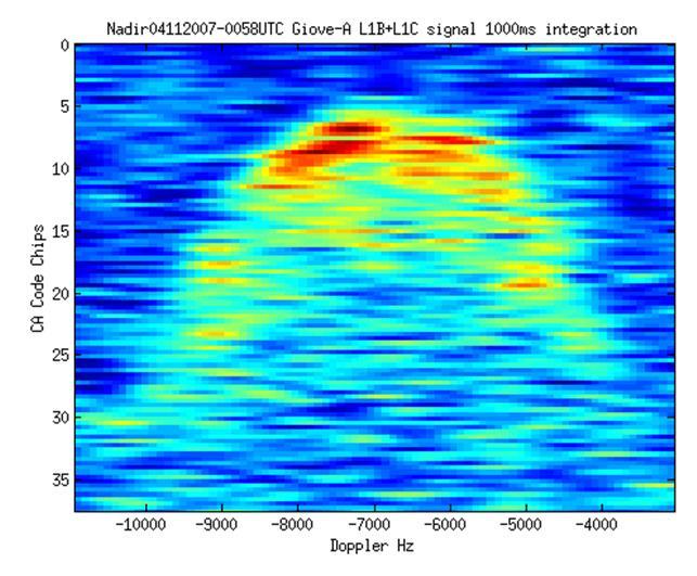
3 Fig 1 (a) Fig 1(b)
 GIOVE-A signal received after reflection off the Arafura Sea near the north coast of Australia.")
4 Fig 2 Figure 1: Galileo signals detected by the UK-DMC satellite GPS Reflectometry Experiment on 4th November 2007 a) GIOVE-A signal received directly (before reflection). b) GIOVE-A signal received after reflection off the Arafura Sea near the north coast of Australia. The signal is spread out in delay and in Doppler shift by the roughness of the ocean caused by 14 mph (22 km/h) winds. Figure 2: Illustration of satellite collecting GPS reflectometry measurements over the ocean and ice as a new means of remote sensing Surrey Satellite Technology Ltd (SSTL) develops innovative technologies to change the economics of space, delivering cost effective satellite missions within rapid timescales. The Company is a world leader in the design, manufacture and operation of high performance small satellites with experience gained over more than 25 years and 27 missions launched. SSTL employs 250 staff working on LEO, GEO and interplanetary missions, turnkey satellite platforms and space-proven satellite subsystems and optical systems. The Company also provides know-how transfer and training programmes and consultancy services, and performs studies for ESA, NASA and commercial customers related to platform design, mission analysis and planning.
5 Based in Guildford, UK, SSTL is owned by the University of Surrey (85%), SSTL staff (5%), and SpaceX of the USA (10%). Notes to editor: Supporting figures can be downloaded from the online press room. These can be previewed in the printable pdf version of this press release, that can be downloaded from the SSTL online press room : SSTL Contact: Audrey Nice, Surrey Satellite Technology Limited Tel: +44 (0) a.nice@sstl.co.uk Press Contact: Robin Wolstenholme, Ballard Communications Management (BCM) Tel: +44 (0) r.wolstenholme@ballard.co.uk
Preparation for Flight of Next Generation Space GNSS Receivers
 Changing the economics of space Preparation for Flight of Next Generation Space GNSS Receivers ICGPSRO, 14-16 th May 2013 Taiwan #0205691 Commercial in Confidence 1 Overview SSTL and Spaceborne GNSS Small
Developments in GNSS Reflectometry from the SGR-ReSI on TDS-1
 Changing the economics of space Developments in GNSS Reflectometry from the SGR-ReSI on TDS-1 Martin Unwin Philip Jales, Jason Tye (SSTL), Brent Abbott SST-US Christine Gommenginger, Giuseppe Foti (NOC)
ESA Study GNSS Reflectometry Instrument & Algorithms NCEO/CEOI Conference, 19 th Sept 2012
 Changing the economics of space ESA Study GNSS Reflectometry Instrument & Algorithms NCEO/CEOI Conference, 19 th Sept 2012 #01xxxxx Overview GNSS for Remote Sensing Concept and UK-DMC Experiment Scientific
A Global System for Detecting Dangerous Seas Using GNSS Bi-static Radar Technology
 A Global System for Detecting Dangerous Seas Using GNSS Bi-static Radar Technology Scott Gleason, Ka Bian, Alex da Silva Curiel Stephen Mackin and Martin Sweeting 20 th AIAA/USU Smallsat Conference, Logan,
GNSS remote sensing (GNSS-RS)
") GPS Galileo GLONASS Beidou GNSS remote sensing (GNSS-RS) Shuanggen Jin ( 金双根 ) Shanghai Astronomical Observatory, CAS, Shanghai 200030, China Email: sgjin@shao.ac.cn Website: http://www.shao.ac.cn/geodesy
GPS Galileo GLONASS Beidou GNSS remote sensing (GNSS-RS) Shuanggen Jin ( 金双根 ) Shanghai Astronomical Observatory, CAS, Shanghai 200030, China Email: sgjin@shao.ac.cn Website: http://www.shao.ac.cn/geodesy
GNSS Remo Sensing in ensin a 6U Cubesat
 GNSS Remote Sensing in a 6U Cubesat Andrew Dempster Remote Sensing using GNSS Radio occultation Well established, with existing missions, v useful for input to weather models Reflectometry Experimental,
Recent GNSS Reflectometry Results from the UK TDS-1 Satellite
 CHANGING THE ECONOMICS OF SPACE Recent GNSS Reflectometry Results from the UK TDS-1 Satellite Martin Unwin ICGPSRO2018, Taipei, 18-20 April 2018 SSTL 2018 Ack: SSTL, NOC, ESA, Surrey, CEOI, UKSA, InnovateUK,
GNSS-Reflectometry for Observation and Monitoring of Earth surface
 GNSS-Reflectometry for Observation and Monitoring of Earth surface Global Navigation meets Geoinformation ESA ESOC Darmstadt, 28-04-2017 Dr. Ing. Domenico Schiavulli INR engineer support at EUMETSAT Outline
Developments in GNSS-Reflectometry from the SGR-ReSI in orbit on TechDemoSat-1
 SSC16-XII-07 Developments in GNSS-Reflectometry from the SGR-ReSI in orbit on TechDemoSat-1 Martin Unwin, Phil Jales, Jason Tye Surrey Satellite Technology Ltd Tycho House, Surrey Research Park Guildford
RAPID DEVELOPMENT OF NAVIGATION PAYLOADS FOR GALILEO FULL OPERATIONAL CAPABILITY
 Changing the economics of space RAPID DEVELOPMENT OF NAVIGATION PAYLOADS FOR GALILEO FULL OPERATIONAL CAPABILITY Alex da Silva Curiel Dubai, January 2011 SSTL - the company UK-based satellite manufacturing
New Technologies for Future EO Instrumentation Mick Johnson
 New Technologies for Future EO Instrumentation Mick Johnson Director of CEOI Monitoring the Earth from Space What data do EO satellites provide? Earth Observation science Operational services Weather,
GNSS Reflections over Ocean Surfaces
 GNSS Reflections over Ocean Surfaces State of the Art F. Soulat CCT Space Reflectometry December 1st 2010 Page n 1 Outline Concept GNSS-R Signal On-going Activities ( Applications) CLS GNSS-R Studies CCT
TN11 - Executive Summary for ESA Contract 21488/08/NL/HE. Prepared by... S Chalkley. Approved by... Technical Director, Aero-Space Division
 CREATING SOLUTIONS THAT WORK Copy No Number Title Classification SEA/08/TN/8155 TN11 - Executive Summary for ESA Contract 21488/08/NL/HE Systems Engineering & Assessment Ltd Beckington Castle PO Box 800
Space Situational Awareness 2015: GPS Applications in Space
 Space Situational Awareness 2015: GPS Applications in Space James J. Miller, Deputy Director Policy & Strategic Communications Division May 13, 2015 GPS Extends the Reach of NASA Networks to Enable New
GNSS Reflectometry and Passive Radar at DLR
 ACES and FUTURE GNSS-Based EARTH OBSERVATION and NAVIGATION 26./27. May 2008, TU München Dr. Thomas Börner, Microwaves and Radar Institute, DLR Overview GNSS Reflectometry a joined proposal of DLR and
Microsatellite Ionospheric Network in Orbit
 Changing the economics of space Microsatellite Ionospheric Network in Orbit Dr Stuart Eves Lead Mission Concepts Engineer SSTL s.eves@sstl.co.uk In tribute to Mino Freund 1962-2012 Introduction Objective
A NANOSATELLITE TO DEMONSTRATE GPS OCEANOGRAPHY REFLECTOMETRY
 A NANOSATELLITE TO DEMONSTRATE GPS OCEANOGRAPHY REFLECTOMETRY Maarten Meerman, Dr. Martin Unwin, Scott Gleason, Dr. Susan Jason, Prof. Sir Martin Sweeting Surrey Satellite Technology Limited Surrey Space
Earth Remote Sensing using Surface-Reflected GNSS Signals (Part II)
") Jet Propulsion Laboratory California Institute of Technology National Aeronautics and Space Administration Jet Propulsion Laboratory California Institute of Technology Pasadena, California Earth Remote
Jet Propulsion Laboratory California Institute of Technology National Aeronautics and Space Administration Jet Propulsion Laboratory California Institute of Technology Pasadena, California Earth Remote
2 INTRODUCTION TO GNSS REFLECTOMERY
 2 INTRODUCTION TO GNSS REFLECTOMERY 2.1 Introduction The use of Global Navigation Satellite Systems (GNSS) signals reflected by the sea surface for altimetry applications was first suggested by Martín-Neira
Global Navigation Satellite Systems (GNSS)
") Global Navigation Satellite Systems (GNSS) Pat Norris MRAeS, FRIN LogicaCMG Business Development Manager Chairman, RAeS Space Group LogicaCMG 2006. All rights reserved 2 Global Navigation Satellite Systems
Global Navigation Satellite Systems (GNSS) Pat Norris MRAeS, FRIN LogicaCMG Business Development Manager Chairman, RAeS Space Group LogicaCMG 2006. All rights reserved 2 Global Navigation Satellite Systems
GNSS Programme. Overview and Status in Europe
 GNSS Programme Overview and Status in Europe Inaugural Forum Satellite Positioning Research and Application Center 23 April 2007 Tokyo Presented by Thomas Naecke (European Commission) Prepared by Daniel
GNSS Remote Sensing: CubeSat case study
 GNSS Remote Sensing: CubeSat case study P-GRESSION system and its background at PoliTo CubeSat Team Lorenzo Feruglio PhD student, Aerospace Engineering LIST OF ACRONYMS LIST OF FIGURES Introduction GNSS
SURREY GSA CATALOG. Surrey Satellite Technology US LLC 8310 South Valley Highway, 3rd Floor, Englewood, CO
 SURREY CATALOG Space-Qualified flight hardware for small satellites, including GPS receivers, Attitude Determination and Control equipment, Communications equipment and Remote Sensing imagers Professional
Basics of Satellite Navigation an Elementary Introduction Prof. Dr. Bernhard Hofmann-Wellenhof Graz, University of Technology, Austria
 Basics of Satellite Navigation an Elementary Introduction Prof. Dr. Bernhard Hofmann-Wellenhof Graz, University of Technology, Austria Basic principles 1.1 Definitions Satellite geodesy (SG) comprises
MEOSAR & GPS ICG WG-B Vienna Austria, June 2016
 MEOSAR & GPS ICG WG-B Vienna Austria, June 2016 Dr. Lisa Mazzuca, Mission Manager NASA Search and Rescue Office Goddard Space Flight Center 1 Overview Cospas-Sarsat System GNSS-enabled Medium Earth Orbit
ASSEMBLY 37TH SESSION
 International Civil Aviation Organization WORKING PAPER A37-WP/195 1 22/9/10 (Information paper) ASSEMBLY 37TH SESSION TECHNICAL COMMISSION Agenda Item 35: The Global Air Traffic Management (ATM) System
GNSS 5 click PID: MIKROE-2670
 GNSS 5 click PID: MIKROE-2670 Determine your current position with GNSS 5 click. It carries the NEO- M8N GNSS receiver module from u-blox. GNSS 5 click is designed to run on a 3.3V power supply. The click
NOAA Satellite and Information Service National Environmental Satellite, Data, and Information Service (NESDIS)
") NOAA Satellite and Information Service National Environmental Satellite, Data, and Information Service (NESDIS) Status of Current and Future Systems (NOAA-WP-33) Presentation to CGMS-40 November 2012;
NOAA Satellite and Information Service National Environmental Satellite, Data, and Information Service (NESDIS) Status of Current and Future Systems (NOAA-WP-33) Presentation to CGMS-40 November 2012;
Using COTs components to Reduce Space Mission Costs: Facts, Myths, Advantages & Pitfalls
 Changing the economics of space Using COTs components to Reduce Space Mission Costs: Facts, Myths, Advantages & Pitfalls Andy Bradford Director of Special Programmes, Surrey Satellite Technology Limited
Dimov Stojče Ilčev. CNS Systems
 Stratospheric Platform Systems (SPS) Presentation by: Dimov Stojče Ilčev Durban University of Technology (DUT) Space Science Centre (SSC) CNS Systems August 2011 SPS for Mobile CNS Applications Stratospheric
S a t e l l i t e T i m e a n d L o c a t i o n. N o v e m b e r John Fischer VP Advanced R&D
 STL - S a t e l l i t e T i m e a n d L o c a t i o n N o v e m b e r 2 0 1 7 John Fischer VP Advanced R&D jfischer@orolia.com 11/28/201 1 7 WHY AUGMENT GNSS? Recent UK Study Economic Input to UK of a
NASA Earth Science Division Status and Decadal Survey Thoughts Michael H. Freilich
 NASA Earth Science Division Status and Decadal Survey Thoughts Michael H. Freilich March 4, 2014 Earth Science Program Overall Strategy Freilich Maintain a balanced program that: advances Earth System
GEROS-ISS: GNSS REflectometry, Radio Occultation and Scatterometry onboard the International Space Station
 GEROS-ISS: GNSS REflectometry, Radio Occultation and Scatterometry onboard the International Space Station J. Wickert, O. Andersen, L. Bertino, A. Camps, E. Cardellach, B. Chapron, C. Gommenginger, J.
DYNAMIC POSITIONING CONFERENCE October 7-8, Sensors II. Redundancy in Dynamic Positioning Systems Based on Satellite Navigation
 Return to Session Directory DYNAMIC POSITIONING CONFERENCE October 7-8, 2008 Sensors II Redundancy in Dynamic Positioning Systems Based on Satellite Navigation Ole Ørpen, Tor Egil Melgård, Arne Norum Fugro
Benefits analysis. Benefit categorisation. Lesley Murphy QinetiQ. ESA Space Weather Programme study Final presentation, 6th-7th December 2001
 Benefits analysis Lesley Murphy QinetiQ ESA Space Weather Programme study Final presentation, 6th-7th December 2001 Benefit categorisation STRATEGIC - affecting Europe s industrial, military, technological
CYGNSS Mission Update
 International Ocean Vector Wind Science Team Meeting Portland, OR 19-21 May 2015 CYGNSS Mission Update Chris Ruf (1) CYGNSS Principal Investigator Paul Chang (2), Maria Paola Clarizia (1), Scott Gleason
SPACE-BASED SOLUTIONS & ANALYTICS
 SPACE-BASED SOLUTIONS & ANALYTICS Enable development and optimisation of airspace use, and no aircraft to be lost again wherever on Earth C N S S y m p o s i u m E u r o c o n t r o l 2 & 3 O c t o b e
Experiences with Fugro's Real Time GPS/GLONASS Orbit/Clock Decimeter Level Precise Positioning System
 Return to Session Directory DYNAMIC POSITIONING CONFERENCE October 13-14, 2009 Sensors Experiences with Fugro's Real Time GPS/GLONASS Orbit/Clock Decimeter Level Precise Positioning System Ole Ørpen and
Principal Investigator Co-Principal Investigator Co-Principal Investigator Prof. Talat Ahmad Vice-Chancellor Jamia Millia Islamia Delhi
 Subject Paper No and Title Module No and Title Module Tag Geology Remote Sensing and GIS Concepts of Global Navigation Satellite RS & GIS XXXIII Principal Investigator Co-Principal Investigator Co-Principal
Outline. GPS RO Overview. COSMIC Overview. COSMIC-2 Overview. Summary 9/29/16
 Bill Schreiner and UCAR/COSMIC Team UCAR COSMIC Program Observation and Analysis Opportunities Collaborating with the ICON and GOLD Missions Sept 27, 216 GPS RO Overview Outline COSMIC Overview COSMIC-2
Remote Sensing with Reflected Signals
 Remote Sensing with Reflected Signals GNSS-R Data Processing Software and Test Analysis Dongkai Yang, Yanan Zhou, and Yan Wang (airplane) istockphoto.com/mark Evans; gpsiff background Authors from a leading
Deriving meteorological observations from intercepted Mode-S EHS messages.
 Deriving meteorological observations from intercepted Mode-S EHS messages. Edmund Keith Stone and Malcolm Kitchen July 28, 2016 Abstract The Met Office has deployed a network of five receivers in the UK
The Future of Search & Rescue. We Save Lives. Steve Waters SAFE Symposium 2016
 The Future of Search & Rescue We Save Lives Steve Waters SAFE Symposium 2016 Covering today.. Understanding the Search and Rescue Ecosystem Helios and GADSS Global Aeronautical Distress and Safety System
Geoscience & Positioning, Navigation and Timing Services for Canadians
 Geoscience & Positioning, Navigation and Timing Services for Canadians Calvin Klatt, Ph.D. Director and Chief Geodesist Natural Resources Canada / Directeur et géodésien principal Ressources naturelles
Scale of the Opportunity. Dr. Jaime Reed, Space Growth Partnership
 Scale of the Opportunity Dr. Jaime Reed, Space Growth Partnership Space : still young, still changing What s the next big leap in transforming our world? 1950s 1960s 1970s 1980s 1990s 2010s Core space
3D Multi-static SAR System for Terrain Imaging Based on Indirect GPS Signals
 Journal of Global Positioning Systems (00) Vol. 1, No. 1: 34-39 3D Multi-static SA System for errain Imaging Based on Indirect GPS Signals Yonghong Li, Chris izos School of Surveying and Spatial Information
GLOBAL POSITIONING SYSTEMS
 GLOBAL POSITIONING SYSTEMS GPS & GIS Fall 2017 Global Positioning Systems GPS is a general term for the navigation system consisting of 24-32 satellites orbiting the Earth, broadcasting data that allows
Observational Research in Air/Sea Interaction
 Remote Sensing Reviews, 1993, Vol. 8, pp. 189-194 Photocopying permitted by license only 1993 Harwood Academic Publishers Printed in the United States of America Observational Research in Air/Sea Interaction
King AbdulAziz University. Faculty of Environmental Design. Geomatics Department. Mobile GIS GEOM 427. Lecture 3
 King AbdulAziz University Faculty of Environmental Design Geomatics Department Mobile GIS GEOM 427 Lecture 3 Ahmed Baik, Ph.D. Email: abaik@kau.edu.sa Eng. Fisal Basheeh Email: fbasaheeh@kau.edu.sa GNSS
EARTH OBSERVATION WITH SMALL SATELLITES
 EARTH OBSERVATION WITH SMALL SATELLITES AT THE FUCHS-GRUPPE B. Penné, C. Tobehn, M. Kassebom, H. Lübberstedt OHB-System GmbH, Universitätsallee 27-29, D-28359 Bremen, Germany www.fuchs-gruppe.com ABSTRACT
THE GIOVE-A SMALL NAVIGATION MISSION
 THE GIOVE-A SMALL NAVIGATION MISSION SSC06-IV-11 Andy Bradford, Philip Davies, Doug Liddle, John Paffett, Prof Sir Martin Sweeting, Wies Tondryk Surrey Satellite Technology Ltd, Surrey Space Centre, Guildford,
GLONASS PROGRAMME UPDATE
 GLONASS PROGRAMME UPDATE Ivan Revnivykh Roscosmos State Space Corporation 11 th Meeting of the International Committee on Global Navigation Satellite System November 7, 2016 Sochi, Russian Federation CONTENTS
The signals from the GPS constellation
 INNOVATION Remote Sensing Reflecting on GPS Sensing Land and Ice from Low Earth Orbit Scott T. Gleason GPS IS NOT YOUR PARENTS POSITIONING SYSTEM. Today, GPS is being used in a variety of unconventional
Development of Ultimate Seamless Positioning System for Global Cellular Phone Platform based on QZSS IMES
 Development of Ultimate Seamless Positioning System for Global Cellular Phone Platform based on QZSS IMES Dinesh Manandhar, Kazuki Okano, Makoto Ishii, Masahiro Asako, Hideyuki Torimoto GNSS Technologies
Prototype Software-based Receiver for Remote Sensing using Reflected GPS Signals. Dinesh Manandhar The University of Tokyo
 Prototype Software-based Receiver for Remote Sensing using Reflected GPS Signals Dinesh Manandhar The University of Tokyo dinesh@qzss.org 1 Contents Background Remote Sensing Capability System Architecture
Commissioning of the NigeriaSat-2 High Resolution Imaging Mission
 Changing the economics of space Commissioning of the NigeriaSat-2 High Resolution Imaging Mission Phil Davies (presenting) SSTL Francis Chizea - NASRDA Andrew Cawthorne SSTL Andrew Carrel - SSTL Luis Gomes
GBAS FOR ATCO. June 2017
 GBAS FOR ATCO June 2017 Disclaimer This presentation is for information purposes only. It should not be relied on as the sole source of information, and should always be used in the context of other authoritative
Reverse Engineering the GPS and Galileo Transmit Antenna Side Lobes. SCPNT Symposium November 11, Shankar Ramakrishnan Advisor: Per Enge
 Reverse Engineering the GPS and Galileo Transmit Antenna Side Lobes SCPNT Symposium November 11, 2015 Shankar Ramakrishnan Advisor: Per Enge Location, Location, Location! Courtesy: www.techprone.com 2
Disruptive technologies and future trends of small satellites
 2016 SSTL Disruptive technologies and future trends of small satellites Luis Gomes Director of EO & science Surrey Satellite Technology Limited Radio Communication June 1978 2016 SSTL The DMC and RapidEye
THE GNSS OCCULTATION, REFLECTOMETRY, AND SCATTEROMETRY SPACE RECEIVER GORS: CURRENT STATUS AND FUTURE PLANS WITHIN GITEWS
 THE GNSS OCCULTATION, REFLECTOMETRY, AND SCATTEROMETRY SPACE RECEIVER GORS: CURRENT STATUS AND FUTURE PLANS WITHIN GITEWS A. Helm (1), G. Beyerle (1), R. Stosius (1), O. Montenbruck (2), S. Yudanov (3),
COMMUNICATIONS FOR MARITIME SAFETY AND EFFICIENCY. Francis Zachariae, Secretary-General, IALA
 COMMUNICATIONS FOR MARITIME SAFETY AND EFFICIENCY Francis Zachariae, Secretary-General, IALA IALA and its Purpose Non profit, international technical association established in 1957 Two Goals aimed at
Nigerian Communications Satellite Ltd. (NIGCOMSAT)
") OVERVIEW OF NIGERIAN SATELLITE AUGMENTATION SYSTEM COMMENCING WITH PILOT DEMONSTRATION TO VALIDATE NATIONAL WORK PLAN presented by Dr. Lawal Lasisi Salami, NIGERIAN COMMUNICATIONS SATELLITE LTD UNDER FEDERAL
OVERVIEW OF NIGERIAN SATELLITE AUGMENTATION SYSTEM COMMENCING WITH PILOT DEMONSTRATION TO VALIDATE NATIONAL WORK PLAN presented by Dr. Lawal Lasisi Salami, NIGERIAN COMMUNICATIONS SATELLITE LTD UNDER FEDERAL
Development in GNSS Space Receivers
 International Technical Symposium on Navigation and Timing November 16th, 2015 Development in GNSS Space Receivers Lionel RIES - CNES 1 C O GNSS in Space : Use-cases and Challenges Receivers State-of-the-Art
Status of the European EGNOS and Galileo Programmes. Frank Udnaes Galileo policy and Infrastructure group EC DG-TREN. June 2008
 Status of the European EGNOS and Galileo Programmes Frank Udnaes Galileo policy and Infrastructure group EC DG-TREN EUROPEAN COMMISSION z June 2008 Galileo An infrastructure 30 satellite Constellation
Global Navigation Satellite System (GLONASS): Status and Development
: Status and Development") Global Navigation Satellite System (GLONASS): Status and Development Tatiana Mirgorodskaya Information and Analysis Center for Positioning, Navigation and Timing Roscosmos State Corporation UN-Nepal Workshop
Global Navigation Satellite System (GLONASS): Status and Development Tatiana Mirgorodskaya Information and Analysis Center for Positioning, Navigation and Timing Roscosmos State Corporation UN-Nepal Workshop
Solar Radar Experiments
 Solar Radar Experiments Paul Rodriguez Plasma Physics Division Naval Research Laboratory Washington, DC 20375 phone: (202) 767-3329 fax: (202) 767-3553 e-mail: paul.rodriguez@nrl.navy.mil Award # N0001498WX30228
2013 RockSat-C Preliminary Design Review
 2013 RockSat-C Preliminary Design Review TEC (The Electronics Club) Eastern Shore Community College Melfa, VA Larry Brantley, Andrew Carlton, Chase Riley, Nygel Meece, Robert Williams Date 10/26/2012 Mission
Satellite Navigation (and positioning)
") Satellite Navigation (and positioning) Picture: ESA AE4E08 Instructors: Sandra Verhagen, Hans van der Marel, Christian Tiberius Course 2010 2011, lecture 1 Today s topics Course organisation Course contents
Satellite Navigation (and positioning) Picture: ESA AE4E08 Instructors: Sandra Verhagen, Hans van der Marel, Christian Tiberius Course 2010 2011, lecture 1 Today s topics Course organisation Course contents
GNSS 5 click PID: MIKROE Weight: 30 g
 GNSS 5 click PID: MIKROE-2670 Weight: 30 g Determine your current position with GNSS 5 click. It carries the NEO M8N GNSS receiver module from u blox. GNSS 5 click is designed to run on a 3.3V power supply.
RemoveDebris Mission: Briefing to UNCOPUOS
 Changing the economics of space RemoveDebris Mission: Briefing to UNCOPUOS 9 th Feb 2015 Chris Saunders Surrey Satellite Technology Limited Guildford, United Kingdom RemoveDebris Mission RemoveDebris is
USE OF EGNOS AND GALILEO FOR SCIENTIFIC APPLICATIONS & INNOVATIVE APPLICATIONS IN NEW DOMAINS
 USE OF EGNOS AND GALILEO FOR SCIENTIFIC APPLICATIONS & INNOVATIVE APPLICATIONS IN NEW DOMAINS Carmen Aguilera Market Development Project Officer European GNSS Supervisory Authority 1 1 GALILEO TECHNICAL
Challenges and Solutions for GPS Receiver Test
 Challenges and Solutions for GPS Receiver Test Presenter: Mirin Lew January 28, 2010 Agenda GPS technology concepts GPS and GNSS overview Assisted GPS (A-GPS) Basic tests required for GPS receiver verification
PARIS Ocean Altimeter
 PARIS Ocean Altimeter M. Martín-Neira, S. D Addio (TEC-ETP) European Space Agency Acknowledgment: C. Buck (TEC-ETP) N. Floury, R. Prieto (TEC-EEP) GNSS-R10 Workshop, UPC, Barcelona, 21-22 October 2010
Sub-Mesoscale Imaging of the Ionosphere with SMAP
 Sub-Mesoscale Imaging of the Ionosphere with SMAP Tony Freeman Xiaoqing Pi Xiaoyan Zhou CEOS Workshop, ASF, Fairbanks, Alaska, December 2009 1 Soil Moisture Active-Passive (SMAP) Overview Baseline Mission
Simulation of GPS-based Launch Vehicle Trajectory Estimation using UNSW Kea GPS Receiver
 Simulation of GPS-based Launch Vehicle Trajectory Estimation using UNSW Kea GPS Receiver Sanat Biswas Australian Centre for Space Engineering Research, UNSW Australia, s.biswas@unsw.edu.au Li Qiao School
Universal Acquisition and Tracking Apparatus for Global Navigation Satellite System (GNSS) Signals: Research Patent Introduction (RPI)
 Signals: Research Patent Introduction (RPI)") Universal Acquisition and Tracking Apparatus for Global Navigation Satellite System (GNSS) Signals: Research Patent Introduction (RPI) 27/01/2014 PAR R.JR. LANDRY, M.A. FORTIN ET J.C. GUAY 0 An RPI is
Universal Acquisition and Tracking Apparatus for Global Navigation Satellite System (GNSS) Signals: Research Patent Introduction (RPI) 27/01/2014 PAR R.JR. LANDRY, M.A. FORTIN ET J.C. GUAY 0 An RPI is
Ocean Altimetry and Wind Applications of a GNSS Nanosatellite Constellation
 Ocean Altimetry and Wind Applications of a GNSS Nanosatellite Constellation Randall Rose* a, Christopher S. Ruf b, Haruo Seki c a Southwest Research Institute, 6220 Culebra Rd. San Antonio, Texas, USA
Space for Europe: A collection of case studies
 Space for Europe: A collection of case studies Introduction Klaus Becher Knowledge & Analysis LLP 1 26/10/2009 Space as a Problem Solver Practical benefits from investments in space technology Cost-saving
Microwave Sensors Subgroup (MSSG) Report
 Report") Microwave Sensors Subgroup (MSSG) Report Feb 17-20, 2014, ESA ESRIN, Frascati, Italy DONG, Xiaolong, MSSG Chair National Space Science Center Chinese Academy of Sciences (MiRS,NSSC,CAS) Email: dongxiaolong@mirslab.cn
Microwave Sensors Subgroup (MSSG) Report Feb 17-20, 2014, ESA ESRIN, Frascati, Italy DONG, Xiaolong, MSSG Chair National Space Science Center Chinese Academy of Sciences (MiRS,NSSC,CAS) Email: dongxiaolong@mirslab.cn
IMO WORLDWIDE RADIONAVIGATION SYSTEM (WWRNS) Study on Communication Techniques for High Accuracy DGPS in the Republic of Korea
 Study on Communication Techniques for High Accuracy DGPS in the Republic of Korea") INTERNATIONAL MARITIME ORGANIZATION E IMO SUB-COMMITTEE ON SAFETY OF NAVIGATION 52nd session Agenda item 12 NAV 52/INF.8 12 May 2006 ENGLISH ONLY WORLDWIDE RADIONAVIGATION SYSTEM (WWRNS) Study on Communication
INTERNATIONAL MARITIME ORGANIZATION E IMO SUB-COMMITTEE ON SAFETY OF NAVIGATION 52nd session Agenda item 12 NAV 52/INF.8 12 May 2006 ENGLISH ONLY WORLDWIDE RADIONAVIGATION SYSTEM (WWRNS) Study on Communication
AIREON SPACE-BASED ADS-B
 AIREON SPACE-BASED ADS-B 2018 Transport Canada Delegates Conference Steve Bellingham Manager, Navigation Systems Engineering Steve.Bellingham@navcanada.ca CNS/ATM Systems Communication Navigation Surveillance
Developments in Satellite Navigation and Wireless Spectrum
 Developments in Satellite Navigation and Wireless Spectrum Chris Hegarty 14 June 2010 Christopher J. Hegarty, D.Sc. The MITRE Corporation chegarty@mitre.org 781-271-2127 (Tel) The contents of this material
BeiDou Space Service Volume Parameters and its Performance
 BeiDou Space Service Volume Parameters and its Performance Prof. Xingqun ZHAN, Shuai JING Shanghai Jiaotong University, China Xiaoliang WANG China Academy of Space Technology Contents 1 Background and
Microwave Sensors Subgroup (MSSG) Report
 Report") Microwave Sensors Subgroup (MSSG) Report CEOS WGCV-35 May 13-17, 2013, Shanghai, China DONG, Xiaolong, MSSG Chair CAS Key Laboratory of Microwave Remote Sensing National Space Science Center Chinese Academy
Microwave Sensors Subgroup (MSSG) Report CEOS WGCV-35 May 13-17, 2013, Shanghai, China DONG, Xiaolong, MSSG Chair CAS Key Laboratory of Microwave Remote Sensing National Space Science Center Chinese Academy
Satellite navigation applications: opportunities from the European GNSS. Fiammetta Diani Deputy Head of Market Development European GNSS Agency
 Satellite navigation applications: opportunities from the European GNSS Fiammetta Diani Deputy Head of Market Development European GNSS Agency FP7 success story in Lithuania COSUDEC Coastal Surveying of
Airborne demonstrators: a small step from space?
 Airborne demonstrators: a small step from space? Mick Johnson Director of CEOI With inputs from: Ray Dunster, Tony Sephton, Martin Cohen (Astrium) Brian Moyna (STFC/RAL) Paul Davey (QinetiQ) Objective
Global Positioning Systems (GPS) Trails: the achilles heel of mapping from the air / satellites
 Trails: the achilles heel of mapping from the air / satellites") Global Positioning Systems (GPS) Trails: the achilles heel of mapping from the air / satellites Google maps updated regularly by local users using GPS Also: http://openstreetmaps.org GPS applications
Global Positioning Systems (GPS) Trails: the achilles heel of mapping from the air / satellites Google maps updated regularly by local users using GPS Also: http://openstreetmaps.org GPS applications
Microwave Remote Sensing
 Provide copy on a CD of the UCAR multi-media tutorial to all in class. Assign Ch-7 and Ch-9 (for two weeks) as reading material for this class. HW#4 (Due in two weeks) Problems 1,2,3 and 4 (Chapter 7)
Maritime Electronics Supporting Unmanned Vessels
 EU-Japan Policy Workshop Maritime Electronics Supporting Unmanned Vessels November 11 th, 2016 TAKUO KASHIWA, Ph.D Furuno Electric Co., Ltd. Agenda Positioning Technologies for Vessel s position Technologies
FREQUENCY DECLARATION FOR THE ARGOS-4 SYSTEM. NOAA-WP-40 presents a summary of frequency declarations for the Argos-4 system.
 Prepared by CNES Agenda Item: I/1 Discussed in WG1 FREQUENCY DECLARATION FOR THE ARGOS-4 SYSTEM NOAA-WP-40 presents a summary of frequency declarations for the Argos-4 system. FREQUENCY DECLARATION FOR
UNITED NATIONS UNIVERSITY Institute for Environment & Human Security (UNU-EHS) Bonn, Germany
 Bonn, Germany") UNITED NATIONS UNIVERSITY Institute for Environment & Human Security (UNU-EHS) Bonn, Germany Introduction to GPS technology Prof. Dr. Jörg Szarzynski Education Programme Director Head of Section EduSphere
UNITED NATIONS UNIVERSITY Institute for Environment & Human Security (UNU-EHS) Bonn, Germany Introduction to GPS technology Prof. Dr. Jörg Szarzynski Education Programme Director Head of Section EduSphere
SAR Interferometry Capabilities of Canada's planned SAR Satellite Constellation
 SAR Interferometry Capabilities of Canada's planned SAR Satellite Constellation Dirk Geudtner, Guy Séguin,, Ralph Girard Canadian Space Agency RADARSAT Follow-on Program CSA is in the middle of a Phase
Copernicus Introduction Lisbon, Portugal 13 th & 14 th February 2014
 Copernicus Introduction Lisbon, Portugal 13 th & 14 th February 2014 Contents Introduction GMES Copernicus Six thematic areas Infrastructure Space data An introduction to Remote Sensing In-situ data Applications
INSTITUTE FOR TELECOMMUNICATIONS RESEARCH (ITR)
") INSTITUTE FOR TELECOMMUNICATIONS RESEARCH (ITR) The ITR is one of Australia s most significant research centres in the area of wireless telecommunications. SUCCESS STORIES The GSN Project The GSN Project
INSTITUTE FOR TELECOMMUNICATIONS RESEARCH (ITR) The ITR is one of Australia s most significant research centres in the area of wireless telecommunications. SUCCESS STORIES The GSN Project The GSN Project
Canadian Coast Guard Review to Implement a Resilient Position, Navigation and Timing Solution for Canada. Mariners Workshop January 31 st, 2018
 Canadian Coast Guard Review to Implement a Resilient Position, Navigation and Timing Solution for Canada Mariners Workshop January 31 st, 2018 Outline Overview of GNSS use in the marine sector CCG Activities
ITU Radiocommunication Sector (ITU-R) and Climate Change. Alexandre VASSILIEV ITU Radiocommunication Bureau
 and Climate Change. Alexandre VASSILIEV ITU Radiocommunication Bureau") ITU Radiocommunication Sector (ITU-R) and Climate Change Alexandre VASSILIEV ITU Radiocommunication Bureau WSIS FORUM 2009, Geneva, 18-22 May 2009 Radio and Information Society Today radio technologies
ITU Radiocommunication Sector (ITU-R) and Climate Change Alexandre VASSILIEV ITU Radiocommunication Bureau WSIS FORUM 2009, Geneva, 18-22 May 2009 Radio and Information Society Today radio technologies
Affordable space based radar for homeland security
 Changing the economics of space Affordable space based radar for homeland security Adam Baker Brent Abbott Phil Whittaker Rachel Bird Luis Gomes Summary Why Radar? However: Radar data is expensive Users
National Aeronautics and Space Administration Jet Propulsion Laboratory California Institute of Technology
 QuikSCAT Mission Status QuikSCAT Follow-on Mission 2 QuikSCAT instrument and spacecraft are healthy, but aging June 19, 2009 will be the 10 year launch anniversary We ve had two significant anomalies during
Perspective of Eastern Global Satellite Navigation Systems
 POSTER 2015, PRAGUE MAY 14 1 Perspective of Eastern Global Satellite Navigation Systems Jiří SVATOŇ Dept. of Radioengineering, Czech Technical University, Technická 2, 166 27 Praha, Czech Republic svatoji2@fel.cvut.cz
An Introduction to Airline Communication Types
 AN INTEL COMPANY An Introduction to Airline Communication Types By Chip Downing, Senior Director, Aerospace & Defense WHEN IT MATTERS, IT RUNS ON WIND RIVER EXECUTIVE SUMMARY Today s global airliners use