Application of Satellite Communication System to Tsunami Early Warning System Satoru Ozawa
|
|
|
- Tobias Mathews
- 5 years ago
- Views:
Transcription

1 Application of Satellite Communication System to Tsunami Early Warning System Satoru Ozawa Space Applications Program Systems Engineering Office Space Applications Mission Directorate Japan Aerospace Exploration Agency 1
2 Today s Talk Damages of 2011 Tohoku Earthquake and Tsunami Application of Next Generation Communication Satellite to Tsunami Early Warning System 2
3 Damages of 2011 Tohoku Earthquake and Tsunami 3


4 Aftermath of 2011 Tohoku Earthquake and Tsunami Aomori Iwate Miyagi Fukushima Otsuchi Town, Iwate Ibaraki Chiba 4
 NTT From Press Release of")
5 Damages of Telecommunication Facilities and Equipment (1/2) Relay Transmission Lines Exchange Buildings Transmission Equipment Collapsed Washed Out Telephone Poles 5 Base Station Facilities (C) NTT From Press Release of Mar 30, 2011
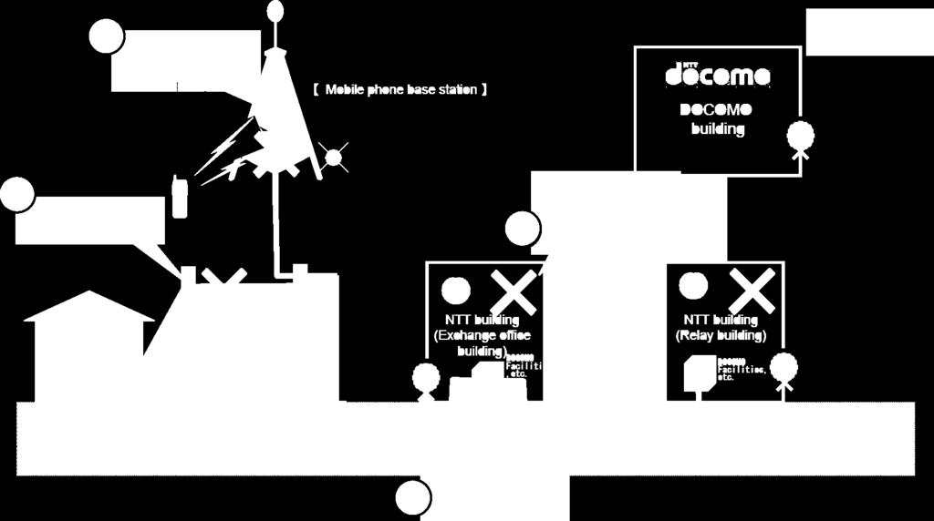


6 Damages of Telecommunication Facilities and Equipment (2/2) 6 (C) NTT From Press Release of Mar 30, 2011


7 JAXA s Support Activities with Communication Satellites Mar 20 Apr 24 Mar 24 May 12 WINDS ETS-VIII WINDS Provided 20Mbps services. Used for Videoconference, IP Phone and Internet. ETS-VIII Provided 768kbps services. Used for IP Phone and Internet. Disaster Area Tsukuba Space Center 7


")


8 JAXA s Support Activity with WINDS (Mar 20 Apr 24) Connected emergency headquarters to Internet through Tsukuba Space Center at 20Mbps. WINDS Tsukuba Space Center Internet High Definition Video Conference Iwate 8 Internet Services

 Provided")


9 JAXA s Support Activity with ETS-VIII (Mar 24 May 12) Provided Internet connection to emergency headquarters and evacuation centers through Tsukuba Space Center at 768kbps. ETS-VIII Satellite Tsukuba Space Center Internet Iwate Otsuchi Town Internet Access Ofunato City Miyagi 9 Onagawa Town Internet Access
10 Telecommunication Problems in Disaster Area Known from Experience Broken off mobile phone connections Earthquake and tsunami hit to wide area and washed out base stations. Lack of precise tsunami information Underestimated tsunami information was announced and corrected information was not transmitted due to unfunctioned base stations. Shortage of high speed internet connections Tsunami washed out backbone network too. 10
11 Application of Next Generation Communication Satellite to Tsunami Early Warning System 11
12 Proposals to Tsunami Early Warning Systems To transmit immediate and precise tsunami alert, we propose: Satellite mobile communication system that can transmit tsunami alert even after base station are destroyed. Satellite sensor network system that can instantaneously collect precise earthquake and tsunami information. High speed satellite communication system that braces the sensor network system from communication failure due to earthquake. 12


13 Concept of Next Generation Satellite Communication System High Speed Satellite Communication Mobile Satellite Communication kbps class Observation Buoy 20 cm-class USAT Mbps class Mobile Phone kbps class Observation Sensors precipitation climate sensor avalanche sensor cliff failure senso ground slide sensor strain meter High Speed Satellite Communication System Satellite Mobile Communication System 13 Satellite Sensor Network System
14 Satellite Mobile Communication System - Satellite/Ground Synthesized Communication System - Increasing communication signal intensity Constructing disaster-resistance networks by sharing frequency with satellite. Next Generation Communication Satellite with 30m Class Antenna Ground service Ground service area Satellite service area f1 f5 f2 f5 f4 f3 f2 f4 f3 f5 f1 fill communication gaps f2 f1 Satellite service provided to f2 f4 f4 f3 f1 f3 f2 f1 f4 f3 f2 f4 f3 Switching center Providing connection between satellite and ground. Outside network By the use of large antenna, this system can transmit tsunami alerts directly to user s mobile phones anywhere in Japan. 14


15 Satellite Sensor Network System (1/3) - JAMSTEC DONET with Communication Satellite - Next Generation Communication Satellite Station This system reinforces JAMSTEC DONET to avoid transmission failure when ground network is broken. 15 Tsunami Alert

16 Satellite Sensor Network System (2/3) - Tsunami Observation with Communication Satellite - Next Generation Communication Satellite Swell Meter DONET Station Buoy Acoustic Communication Sea Bottom Tsunai Sensor 16 Tsunami Alert This system can instantaneously collect tsunami information from buoys far from coasts and send a tsunami alert right after tsunami occurs.

17 Satellite Sensor Network System (3/3) - GPS Tsunami Meter Data Transmission Experiment - ETS-VIII NICT Kashima MODEM Earth Station Muroto Peninsula Kuroshio Firm Experimental Earth Station 17 Kochi National College of Technology This test will confirm if the next generation communication satellite in geostationary orbit can transmit signals directly to buoys.


18 Satellite Components under Development Digital Channelizer realizes flexible adjustment of every beam s frequency bandwidth. With this, the satellite system can concentrate and increase communication traffic to disaster areas. 30m Class Large Space Antenna can directly connect to mobile phones on the ground. Frequency Traffic to Disaster Area Frequency Digital Beam Forming can deform antenna beam shapes by combining phase and amplitude of feed beam. JAXA s existing satellites use analog beam forming. The next generation satellites employs digital version of beam forming. Beam to all Japan Beam to wide area Beam to sea lanes 18

19 Large Deployable Reflector 19
20 Concluding Remarks 20
21 Concluding Remarks From the experience of 2011 Tohoku Earthquake and Tsunami, for Tsunami Early Warning Systems, we concluded the following satellite communication systems are required: Satellite mobile communication system Satellite sensor network system High speed satellite communication system For a realization of required communication systems, we are researching and developing the state of the art technologies. Especially, we have succeeded in the development of large space antenna. We strongly intend to continue in developing the new technologies for the satellite communication systems and to put the satellite systems into practical use. 21
22 22
GNSS (GPS) buoy array in the Pacific for natural disaster mitigation. Teruyuki KATO Earthquake Research Institute the University of Tokyo, Japan
 buoy array in the Pacific for natural disaster mitigation. Teruyuki KATO Earthquake Research Institute the University of Tokyo, Japan") GNSS (GPS) buoy array in the Pacific for natural disaster mitigation Teruyuki KATO Earthquake Research Institute the University of Tokyo, Japan 1 (Modified from Oki & Koketsu, 2011) Historical megaquakes
GNSS (GPS) buoy array in the Pacific for natural disaster mitigation Teruyuki KATO Earthquake Research Institute the University of Tokyo, Japan 1 (Modified from Oki & Koketsu, 2011) Historical megaquakes
GNSS buoy array in the ocean for natural hazard mitigation. Teruyuki KATO Earthquake Research Institute the University of Tokyo, Japan
 GNSS buoy array in the ocean for natural hazard mitigation Teruyuki KATO Earthquake Research Institute the University of Tokyo, Japan 1 GNSS applications in Earth science From static to high-rate observations
The technical contribution of QZSS and GNSS to Tsunami early warning system
 0/17 Tsunami Workshop by Sentinel Asia @Sendai International Center Meeting Room 5 The technical contribution of QZSS and GNSS to Tsunami early warning system July 3, 2012 K. Mutoh, J. Yamashita, and S.
Space Japan Club. Mr. Masaaki Shimada Senior Engineer, Aerospace Research and Development Directorate Japan Aerospace Exploration Agency
 Space Japan Club -Record of the man who sweated for satellite communications- Mr. Masaaki Shimada Senior Engineer, Aerospace Research and Development Directorate Japan Aerospace Exploration Agency Mr.
Overview of Utilization of WINDS
 Overview of Utilization of WINDS 2nd Joint Project Team Meeting for Sentinel Asia STEP3 Yangon, Myanmar Sachiko Hozawa Space Application and Promotion Center (SAPC) Japan Aerospace Exploration Agency (JAXA)
GNSS Buoy Array in the Ocean for a Synthetic Geohazards Monitoring System
 GNSS Buoy Array in the Ocean for a Synthetic Geohazards Monitoring System Teruyuki Kato, Earthq. Res. Inst., Univ. Tokyo, Japan Yukihiro Terada, Nat. Inst. Tech., Kochi Col., Japan Keiichi Tadokoro, Grad.
Large Deployable Reflector on Engineering Test Satellite VIII
 Large Deployable Reflector on Engineering Test Satellite VIII Japan Aerospace Exploration Agency Space Applications Mission Directorate Satoru OZAWA 1 Today s Talk Large Deployable Reflector (LDR) What
3-9 High Accuracy Clock (HAC)
") 3-9 High Accuracy Clock (HAC) NODA Hiroyuki, SANO Kazuhiko, and HAMA Shin ichi To obtain the basic technology of satellite positioning system, NASDA will conduct the experiments of ETS-VIII high accurate
3-9 High Accuracy Clock (HAC) NODA Hiroyuki, SANO Kazuhiko, and HAMA Shin ichi To obtain the basic technology of satellite positioning system, NASDA will conduct the experiments of ETS-VIII high accurate
FINAL ANNOUNCEMENT The 1 st Space Exploration and Kibo Utilization for Asia Workshop. LAPAN Headquarters, Jakarta, Indonesia.
 FINAL ANNOUNCEMENT The 1 st Space Exploration and Kibo Utilization for Asia Workshop LAPAN Headquarters, Jakarta, Indonesia May 28, 2015 We are pleased to announce that The 1st Space Exploration and Kibo
Wireless Future. OUTLINE My thought on Wireless Future Before March 11 After March 11
 VTC-Spring Panel:Wireless Future, 8:30~10:00am, 17 May, 2011, Budapest, Hungary Wireless Future Tohoku U. Aobayama-campus Fumiyuki Adachi Wireless Signal Processing & Networking (WSP&N) Lab. Dept. of Electrical
GEONET -CORS Network of japan-
 GEONET -CORS Network of japan- Basara Miyahara Geospatial Information Authority of Japan Geospatial and GNSS CORS Infrastructure Forum Kuala Lumpur - Malaysia Geospatial Information Authority of Japan
CALL359 JAPAN S EARTHQUAKE 2011, MARCH, 11
 CALL359 JAPAN S EARTHQUAKE 2011, MARCH, 11 PM for International Charter Dr. Masahiko Nagai JAXA - AIT 25th Meeting of the International Charter May 12 th 2011 on 2011, March, 11 at 14:46 (JST) Iwate Pref.
New Approach for Tsunami Detection Based on RTK-GNSS Using Network of Ships
 New Approach for Tsunami Detection Based on RTK-GNSS Using Network of Ships Tokyo University of Marine Science and Technology Ryuta Nakaosone Nobuaki Kubo Background After the Indian Ocean Tsunami on 2004,
Technology of Precise Orbit Determination
 Technology of Precise Orbit Determination V Seiji Katagiri V Yousuke Yamamoto (Manuscript received March 19, 2008) Since 1971, most domestic orbit determination systems have been developed by Fujitsu and
Overview of the Tracking and Control Center at the Tsukuba Space Center
 Overview of the Tracking and Control Center at the Tsukuba Space Center Table of Contents 1. Outline of the Tsukuba Space Center 2 2. Role of the Tsukuba Tracking and Control Center 2 3. Tracking and Control
3-2 Configuration for Mobile Communication Satellite System and Broadcasting Satellite Systems
 3-2 Configuration for Mobile Communication Satellite System and Broadcasting Satellite Systems KOZONO Shin-ichi To realize S-band mobile satellite communications and broadcasting systems, onboard mission
KNOWLEDGE NOTE 3-2. Emergency Communication. CLUSTER 3: Emergency Response. Emergency Communication
 KNOWLEDGE NOTE 3-2 CLUSTER 3: Emergency Response 1 Prepared by Rajib Shaw, Brett Peary, Ai Ideta, and Yukiko Takeuchi, Kyoto University; and Japan s Ministry of Internal Affairs and Communication 2 KNOWLEDGE
ITU Radiocommunication Sector (ITU-R) and Climate Change. Alexandre VASSILIEV ITU Radiocommunication Bureau
 and Climate Change. Alexandre VASSILIEV ITU Radiocommunication Bureau") ITU Radiocommunication Sector (ITU-R) and Climate Change Alexandre VASSILIEV ITU Radiocommunication Bureau WSIS FORUM 2009, Geneva, 18-22 May 2009 Radio and Information Society Today radio technologies
ITU Radiocommunication Sector (ITU-R) and Climate Change Alexandre VASSILIEV ITU Radiocommunication Bureau WSIS FORUM 2009, Geneva, 18-22 May 2009 Radio and Information Society Today radio technologies
S-Band: a new space for mobile communication in Europe Orazio Pulvirenti MSS Project Manager Eutelsat Innovation Team
 S-Band: a new space for mobile communication in Europe Orazio Pulvirenti MSS Project Manager Eutelsat Innovation Team Evolutions in Satellite Telecommunication Ground Segments Noordwijk, June 5 th 2008
Developments of GNSS Buoy for a Synthetic Geohazards Monitoring System
 ICG12 in Kyoto (1 Dec., 2017) Developments of GNSS Buoy for a Synthetic Geohazards Monitoring System Teruyuki Kato, Earthq. Res. Inst., Univ. Tokyo, Japan Yukihiro Terada, Nat. Inst. Tech., Kochi Col.,
Useful Definitions. The two books are:
 RESOURCES LIBRARY NEWS ARTICLES PAPERS & DOCUMENTS TECHNICAL DOCUMENTS PACIFIC ISLAND REGIONAL MAPS LINKS TO PAGES OF INTEREST Useful Definitions The following are some definitions of terms from two books
第 XVII 部 災害時における情報通信基盤の開発
 XVII W I D E P R O J E C T 17 1 LifeLine Station (LLS) WG LifeLine Station (LLS) WG was launched in 2008 aiming for designing and developing an architecture of an information package for post-disaster
NASDA S PRECISE ORBIT DETERMINATION SYSTEM
 NASDA S PRECISE ORBIT DETERMINATION SYSTEM Maki Maeda Takashi Uchimura, Akinobu Suzuki, Mikio Sawabe National Space Development Agency of Japan (NASDA) Sengen 2-1-1, Tsukuba, Ibaraki, 305-8505, JAPAN E-mail:
Proposal. ITU/PITA RRS-16 for Asia & Pacific Emergency Communications: The Role of Satellites
 ITU/PITA RRS-16 for Asia & Pacific Emergency Communications: Proposal The Role of Satellites Raquib Masashi PRAMANIK SKY Perfect JSAT Corporation JAPAN 21 September 2016 JSAT Background Largest Satellite
TIME TRANSFER EXPERIMENT BY TCE ON THE ETS-VIII SATELLITE
 TIME TRANSFER EXPERIMENT BY TCE ON THE ETS-VIII SATELLITE Fumimaru Nakagawa, Yasuhiro Takahashi, Jun Amagai, Ryo Tabuchi, Shin ichi Hama, and Mizuhiko Hosokawa National Institute of Information and Communications
Disaster Monitoring using remote sensing for the Great East Japan Earthauake
 Disaster Monitoring using remote sensing for the Great East Japan Earthauake Kazuo Yoshikawa, Yuki Okajima and Susumu Takagishi, Japan Key words: Disaster Monitoring, TerraSAR-X, Change Detection, Earthquake,
High Precision Navigation Capabilities(L1-SAIF) and Applications Using Japanese Quasi-Zenith Satellite System (QZSS)
 and Applications Using Japanese Quasi-Zenith Satellite System (QZSS)") High Precision Navigation Capabilities(L1-SAIF) and Applications Using Japanese Quasi-Zenith Satellite System (QZSS) ICG WG-B Application SG Meeting Munich, Germany March 12, 2012 Satellite Positioning
High Precision Navigation Capabilities(L1-SAIF) and Applications Using Japanese Quasi-Zenith Satellite System (QZSS) ICG WG-B Application SG Meeting Munich, Germany March 12, 2012 Satellite Positioning
Table Satellites used for observations by members of the Disaster Charter and others (except Daichi)
") 2.1.4 Cooperation with from overseas institutions JAXA asked Sentinel Asia and, on behalf of the Cabinet Office, the Disaster Charter to carry out emergency observations immediately after the earthquake
2.1.4 Cooperation with from overseas institutions JAXA asked Sentinel Asia and, on behalf of the Cabinet Office, the Disaster Charter to carry out emergency observations immediately after the earthquake
FEB NEWS. No. 425
 FEB. 2013 NEWS No. 425 2 01 02 03 04 05 06 07 Position coordinates and time are the essential physical parameters in science and technology. Very Long Baseline Interferometry (VLBI) is technology that
Galileo signal reflections used for monitoring waves and weather at sea
 Press Release Monday 26 th November 2007 Galileo signal reflections used for monitoring waves and weather at sea Surrey Satellite Technology Ltd (SSTL) and the University of Surrey have succeeded for the
Prospect for Global Positioning Augmentation Service by QZSS
 Prospect for Global Positioning Augmentation Service by QZSS Global Positioning Augmentation Service Corporation Director, Yoshikatsu Iotake Feb. 6, 2018 Copyright 2018 Global Positioning Augmentation
Addressable Radios for Emergency Alert (AREA): WorldSpace Satellite Radio
: WorldSpace Satellite Radio") Addressable Radios for Emergency Alert (AREA): A WorldSpace solution for effective delivery of alerts S.Rangarajan, Jerome Soumagne and Jean-Luc Vignaud WorldSpace Satellite Radio srangarajan@worldspace.com,
Addressable Radios for Emergency Alert (AREA): A WorldSpace solution for effective delivery of alerts S.Rangarajan, Jerome Soumagne and Jean-Luc Vignaud WorldSpace Satellite Radio srangarajan@worldspace.com,
RADIOACTIVE CONTAMINATION OF NEST MATERIAL DUE TO THE FUKUSHIMA NUCLEAR ACCIDENT IN PASSERINE BIRDS
 RADIOACTIVE CONTAMINATION OF NEST MATERIAL DUE TO THE FUKUSHIMA NUCLEAR ACCIDENT IN PASSERINE BIRDS Matsui S 1, Kasahara S 1, Morimoto G 1, Mikami OK 2, Watanabe M 3, Ueda K 1 1 Rikkyo Uni, 2 Iwate- Medical
Radiocommunications and climate changes
 Radiocommunications and climate changes Durban, South Africa 1 December 2011 COP-17 Vadim Nozdrin, Counselor, ITU-R Study Group 7 Study Group Department Radiocommunication Bureau
Structure Health Monitoring System Using MEMS-Applied Vibration Sensor
 Structure Health Monitoring System Using MEMS-Applied Vibration Sensor SAKAUE Satoru MURAKAMI Keizo KITAGAWA Shinji ABSTRACT Recently, studies have come to be increasingly energetically conducted on structure
In this unit we are going to speak about satellite communications. Satellites are useful for connecting to remote areas, or when you want to
 In this unit we are going to speak about satellite communications. Satellites are useful for connecting to remote areas, or when you want to broadcast video or data with minimal infrastructure. A communications
National SPace Organization
 National SPace Organization A center of innovation and excellence for space technology Bo Chen National Space Organization Presented at JPTM 2014, Sentinel Asia Yangon, Myanmar, 11/19-21 NARLabs-NSPO About
Computers Watching Tsunamis DEEP- O C E A N A S S E S S M E N T A N D R E P O R T I N G ( D A R T I I )
") Computers Watching Tsunamis DEEP- O C E A N A S S E S S M E N T A N D R E P O R T I N G ( D A R T I I ) Origins of Tsunamis 1 Origins of Tsunamis 1 Energy density I(r) in terms of energy, E, and distance,
Computers Watching Tsunamis DEEP- O C E A N A S S E S S M E N T A N D R E P O R T I N G ( D A R T I I ) Origins of Tsunamis 1 Origins of Tsunamis 1 Energy density I(r) in terms of energy, E, and distance,
The Role of Urban Development Patterns in Mitigating the Effects of Tsunami Run-up: Final Report
 J-RAPID Final Symposium Sendai, Japan The Role of Urban Development Patterns in Mitigating the Effects of Tsunami Run-up: Final Report March 6, 2013 Fumio Yamazaki, Chiba University, Japan and Ronald T.
Overview of the inter-orbit and orbit-to-ground laser communication demonstration by OICETS
 Overview of the inter-orbit and orbit-to-ground laser communication demonstration by OICETS Takashi Jono *a, Yoshihisa Takayama a, Koichi Shiratama b, Ichiro Mase b, Benoit Demelenne c, Zoran Sodnik d,
IPSTAR Disaster Recovery and Emergency Communications
 IPSTAR Disaster Recovery and Emergency Communications March 2009 COPYRIGHT THAICOM PLC 2009 PROPRIETARY Content Introduction 3 Advantages 4 Applications 5 Equipment 6-7 IPSTAR Enterprise Series IPSTAR
A MULTIFUNCTION SATELLITE BACKHAUL SYSTEM FOR AIRCRAFT FLIGHT TEST APPLICATIONS
 A MULTIFUNCTION SATELLITE BACKHAUL SYSTEM FOR AIRCRAFT FLIGHT TEST APPLICATIONS Item Type text; Proceedings Authors Bell, John J. (Jack); Mileshko, James; Payne, Edward L.; Wagler, Paul Publisher International
Futrajaya, Malaysia JULY 12, Jeong Heon SONG. Korea Aerospace Research Institution
 J P T M 2 0 1 1 Futrajaya, Malaysia JULY 12, 2011 Jeong Heon SONG Korea Aerospace Research Institution Outline Contribution of KARI Sentinel Asia / Data Provider Node International Charter KARI Space Activities
2 Overview of the Wideband InterNetworking Engineering Test and Demonstration Satellite Project
 2 Overview of the Wideband InterNetworking Engineering Test and Demonstration Satellite Project Wideband InterNetworking engineering test and Demonstration Satellite (WINDS) is an experimental satellite
An Introduction to Airline Communication Types
 AN INTEL COMPANY An Introduction to Airline Communication Types By Chip Downing, Senior Director, Aerospace & Defense WHEN IT MATTERS, IT RUNS ON WIND RIVER EXECUTIVE SUMMARY Today s global airliners use
Unguided Media and Matched Filter After this lecture, you will be able to Example?
 Unguided Media and Matched Filter After this lecture, you will be able to describe the physical and transmission characteristics of various unguided media Example? B.1 Unguided media Guided to unguided
System development and performance of the Deep-ocean Assessment and Reporting of Tsunamis (DART) system from
 system from") ITS 2001 Proceedings, NHTMP Review Session, Paper R-24 317 System development and performance of the Deep-ocean Assessment and Reporting of Tsunamis (DART) system from 1997 2001 Christian Meinig, Marie
ITS 2001 Proceedings, NHTMP Review Session, Paper R-24 317 System development and performance of the Deep-ocean Assessment and Reporting of Tsunamis (DART) system from 1997 2001 Christian Meinig, Marie
W-Band Satellite Transmission in the WAVE Mission
 W-Band Satellite Transmission in the WAVE Mission A. Jebril, M. Lucente, M. Ruggieri, T. Rossi University of Rome-Tor Vergata, Dept. of Electronic Engineering, Via del Politecnico 1, 00133 Rome - Italy
Satellite Communications in the Asia-Pacific Region, Today and Tomorrow
 Satellite Communications in the Asia-Pacific Region, Today and Tomorrow KEYNOTE SPEECH By Yasuo Otaki President The Asia-Pacific Satellite Communications Council At the Workshop on Satellites in IP and
BHN's Engagement in Disaster Risk Reduction. Supporting Activities and Human Resource Development for Disaster Risk Reduction
 The Third UN World Conference on Disaster Risk Reduction BHN's Engagement in Disaster Risk Reduction Supporting Activities and Human Resource Development for Disaster Risk Reduction March 14, 2015 Approved
ARTES 1 ROLLING WORKPLAN 2010
 ARTES 1 ROLLING WORKPLAN 2010 INTRODUCTION This document presents the ARTES 1 Rolling Workplan for 2010. Activities have been selected based on the ARTES Call for Ideas, consultation with participating
Sea surface temperature observation through clouds by the Advanced Microwave Scanning Radiometer 2
 Sea surface temperature observation through clouds by the Advanced Microwave Scanning Radiometer 2 Akira Shibata Remote Sensing Technology Center of Japan (RESTEC) Tsukuba-Mitsui blds. 18F, 1-6-1 Takezono,
Satisfying growth demands for offshore communications
 Satisfying growth demands for offshore communications Michael Carter, Sales Director Network and Data Services GVF Oil & Gas Communications Europe 2014, Aberdeen Overview 1. Who we are 2. Key drivers for
SATELLITE SUBSYSTEMS. Networks and Communication Department. Dr. Marwah Ahmed
 1 SATELLITE SUBSYSTEMS Networks and Communication Department Dr. Marwah Ahmed Outlines Attitude and Orbit Control System (AOCS) Telemetry, Tracking, Command and Monitoring (TTC & M) Power System Communication
The Network Effect, 5G and Satellite Communications
 The Network Effect, 5G and Satellite Communications October 2017 Bruce R. Elbert President and Principal Consultant Application Technology Strategy, L.L.C. Application Technology Strategy, LLC NE 1 Network
ViaSat Service Manual
 Summary The following information discusses who ViaSat Communications is as a company and the corporate mission. This Job Aid covers: Who is ViaSat, Inc.? How the ViaSat Service Works ViaSat Ka-Band Satellites
Remote sensing radio applications/ systems for environmental monitoring
 Remote sensing radio applications/ systems for environmental monitoring Alexandre VASSILIEV ITU Radiocommunication Bureau phone: +41 22 7305924 e-mail: alexandre.vassiliev@itu.int 1 Source: European Space
Development of Wireless Link Applications for Small UAS in Japan
 ICAO NAM/CAR/SAM RPG Workshop for ITU WRC-2019 Development of Wireless Link Applications for Small UAS in Japan February 6-7, 2018 Hiroyuki Tsuji National Institute of Information and Communications Technology
Second explosion at Japan nuclear plant
 www.breaking News English.com Ready-to-use ESL/EFL Lessons by Sean Banville 1,000 IDEAS & ACTIVITIES FOR LANGUAGE TEACHERS The Breaking News English.com Resource Book http://www.breakingnewsenglish.com/book.html
1. What is the bandwidth of a signal that ranges from 40 KHz to 4 MHz? a MHz (4M -40K) b. 36 MHz c. 360 KHz d. 396 KHz
 b. 36 MHz c. 360 KHz d. 396 KHz") Question 1: Choose the correct answer 1. What is the bandwidth of a signal that ranges from 40 KHz to 4 MHz? a. 3.96 MHz (4M -40K) b. 36 MHz c. 360 KHz d. 396 KHz 2. Consider a noiseless channel with a
Question 1: Choose the correct answer 1. What is the bandwidth of a signal that ranges from 40 KHz to 4 MHz? a. 3.96 MHz (4M -40K) b. 36 MHz c. 360 KHz d. 396 KHz 2. Consider a noiseless channel with a
Tsunami detection in the ionosphere
 Tsunami detection in the ionosphere [by Juliette Artru (Caltech, Pasadena, USA), Philippe Lognonné, Giovanni Occhipinti, François Crespon, Raphael Garcia (IPGP, Paris, France), Eric Jeansou, Noveltis (Toulouse,
Disaster Management in Japan
 Disaster Management in Japan June 2014 Koichi KATAGIRI Ministry of Internal Affairs and Communications (MIC) JAPAN Comparison of Natural Disasters in Japan and Other Parts of the World (1) 1 Number of
ARGOS-3: Just Do It. Bill Woodward, CLS America Michel Guigue, CLS Toulouse Christian Ortega, CLS Toulouse
 ARGOS-3: Just Do It Bill Woodward, CLS America Michel Guigue, CLS Toulouse Christian Ortega, CLS Toulouse REMINDER ARGOS-3 FEATURES Sat Pass Prediction Two-Way Communication High Data Rate Managing Transmission,
Before the FEDERAL COMMUNICATIONS COMMISSION Washington, DC ) ) ) ) ) ) ) ) ) ) ) PETITION FOR ETC DESIGNATION OF HUGHES NETWORK SYSTEMS, LLC
 ) ) ) ) ) ) ) ) ) ) PETITION FOR ETC DESIGNATION OF HUGHES NETWORK SYSTEMS, LLC") Before the FEDERAL COMMUNICATIONS COMMISSION Washington, DC 20554 In the Matter of Telecommunications Carriers Eligible to Receive Universal Service Support Petition of Hughes Network Systems, LLC for
Before the FEDERAL COMMUNICATIONS COMMISSION Washington, DC 20554 In the Matter of Telecommunications Carriers Eligible to Receive Universal Service Support Petition of Hughes Network Systems, LLC for
Design of Ka-Band Satellite Links in Indonesia
 Design of Ka-Band Satellite Links in Indonesia Zulfajri Basri Hasanuddin International Science Index, Electronics and Communication Engineering waset.org/publication/9999249 Abstract There is an increasing
 APPLICATION OF HIGH-RESOLUTION SATELLITE IMAGERRY FOR DETECTION OF DISASTER DAMAGES AND DISASTER MONITORING -THROUGH THE PRODUCE OF INTERPRETATION CHARACTERSTICS CARDS OF SATELLITE IMAGERIES FOR DISASTER
Real-time Earthquake and Tsunami Early Warning System
 Real-time Earthquake and Tsunami Early Warning System Dr. Gerald Bawden NASA Mike Angove, Dr. Charles McCreery, Dr. Paul Huang NOAA Dr. Timothy Melbourne Central Washington University Dr. Yehuda Bock UC
UPDATE ON COMS PROGRAM
 Prepared by KMA Agenda Item: C.2 Discussed in Plenary UPDATE ON COMS PROGRAM This document is to update the COMS program as a part of CGMS-34-WMO-WP-25. Currently, the integration of COMS system has been
High Speed Data Transmission and Processing Systems for e-vlbi Observations
 High Speed Data Transmission and Processing Systems for e-vlbi Observations Yasuhiro Koyama, Tetsuro Kondo, and Junichi Nakajima Communications Research Laboratory, Kashima Space Research Center 893-1
GNSS Reflectometry and Passive Radar at DLR
 ACES and FUTURE GNSS-Based EARTH OBSERVATION and NAVIGATION 26./27. May 2008, TU München Dr. Thomas Börner, Microwaves and Radar Institute, DLR Overview GNSS Reflectometry a joined proposal of DLR and
Development of Microsatellite to Detect Illegal Fishing MS-SAT
 Development of Microsatellite to Detect Illegal Fishing MS-SAT Ernest S. C. P. Bintang A.S.W.A.M. Department of Aerospace Engineering Faculty of Mechanical and Aerospace Engineering Institut Teknologi
Chapter 1 INTRODUCTION
 Chapter 1 INTRODUCTION 1 The History of Mobile Radio Communication (1/3) 1880: Hertz Initial demonstration of practical radio communication 1897: Marconi Radio transmission to a tugboat over an 18 mi path
Computer Networks 1 (Mạng Máy Tính 1) Lectured by: Nguyễn Đức Thái
 Lectured by: Nguyễn Đức Thái") Computer Networks 1 (Mạng Máy Tính 1) Lectured by: Nguyễn Đức Thái Lecture 2: Communication Media Reference: Chapter 2 - Computer Networks, Andrew S. Tanenbaum, 4th Edition, Prentice Hall, 2003. Content
Computer Networks 1 (Mạng Máy Tính 1) Lectured by: Nguyễn Đức Thái Lecture 2: Communication Media Reference: Chapter 2 - Computer Networks, Andrew S. Tanenbaum, 4th Edition, Prentice Hall, 2003. Content
GNSS and M2M for Automated Driving in Japan Masao FUKUSHIMA SIP Sub-Program Director ITS Technical Consultant, NISSAN MOTOR CO.,LTD May. 15.
 ICT SPRING EUROPE 2018 GNSS and M2M for Automated Driving in Japan Masao FUKUSHIMA SIP Sub-Program Director ITS Technical Consultant, NISSAN MOTOR CO.,LTD May. 15. 2018 SIP : Cross-Ministerial Strategic
RESOLUTION A.659(16) adopted on 19 October 1989 PROVISION OF RADIO SERVICES FOR THE GLOBAL MARITIME DISTRESS AND SAFETY SYSTEM
 adopted on 19 October 1989 PROVISION OF RADIO SERVICES FOR THE GLOBAL MARITIME DISTRESS AND SAFETY SYSTEM") INTERNATIONAL MARITIME ORGANIZATION RESOLUTION A.659(16) adopted on 19 October 1989 A 16/Res.659 30 November 1989 Original: ENGLISH ASSEMBLY - 16th session Agenda item 10 IMO RESOLUTION A.659(16) adopted
INTERNATIONAL MARITIME ORGANIZATION RESOLUTION A.659(16) adopted on 19 October 1989 A 16/Res.659 30 November 1989 Original: ENGLISH ASSEMBLY - 16th session Agenda item 10 IMO RESOLUTION A.659(16) adopted
Class Overview. Antenna Fundamentals Repeaters Duplex and Simplex Nets and Frequencies Cool Radio Functions Review
 Class Overview Antenna Fundamentals Repeaters Duplex and Simplex Nets and Frequencies Cool Radio Functions Review Antennas Antennas An antenna is a device used for converting electrical currents into electromagnetic
ELECTRONIC COMMUNICATIONS COMMITTEE
 ELECTRONIC COMMUNICATIONS COMMITTEE ECC Decision of 12 November 2010 on sharing conditions in the 10.6-10.68 GHz band between the fixed service, mobile service and Earth exploration satellite service (passive)
Lesson Title: Using Waves to Communicate Subject Grade Level Timeline. Physical Science minutes. Objectives
 Lesson Title: Using Waves to Communicate Subject Grade Level Timeline Physical Science 7-8 45 minutes Objectives This lesson investigates the difference between longitudinal waves and transverse waves,
Nigerian Communications Satellite Ltd. (NIGCOMSAT)
") OVERVIEW OF NIGERIAN SATELLITE AUGMENTATION SYSTEM COMMENCING WITH PILOT DEMONSTRATION TO VALIDATE NATIONAL WORK PLAN presented by Dr. Lawal Lasisi Salami, NIGERIAN COMMUNICATIONS SATELLITE LTD UNDER FEDERAL
OVERVIEW OF NIGERIAN SATELLITE AUGMENTATION SYSTEM COMMENCING WITH PILOT DEMONSTRATION TO VALIDATE NATIONAL WORK PLAN presented by Dr. Lawal Lasisi Salami, NIGERIAN COMMUNICATIONS SATELLITE LTD UNDER FEDERAL
Workshop on Intelligent System and Applications (ISA 17)
") Telemetry Mining for Space System Sara Abdelghafar Ahmed PhD student, Al-Azhar University Member of SRGE Workshop on Intelligent System and Applications (ISA 17) 13 May 2017 Workshop on Intelligent System
Telemetry Mining for Space System Sara Abdelghafar Ahmed PhD student, Al-Azhar University Member of SRGE Workshop on Intelligent System and Applications (ISA 17) 13 May 2017 Workshop on Intelligent System
Autonomous Cooperative Robots for Space Structure Assembly and Maintenance
 Proceeding of the 7 th International Symposium on Artificial Intelligence, Robotics and Automation in Space: i-sairas 2003, NARA, Japan, May 19-23, 2003 Autonomous Cooperative Robots for Space Structure
Concept of Operations. Emergency Support Function (ESF) # 2 Communications
 # 2 Communications") Concept of Operations Lead Agency Support Agencies Emergency Support Function (ESF) # 2 Communications Franklin County Sheriff s Office (FCSO) Amateur Radio Emergency Services (ARES) Apalachicola Police
Concept of Operations Lead Agency Support Agencies Emergency Support Function (ESF) # 2 Communications Franklin County Sheriff s Office (FCSO) Amateur Radio Emergency Services (ARES) Apalachicola Police
Amateur Satellite and APRS Data Links. Polar Technology Conference April Bob Bruninga Midns: Kren, Aspholm
 Amateur Satellite and APRS Data Links Polar Technology Conference April 2012 Psat ODTML Ocean Buoys w/ RF Terminals GROUND STATION Bob Bruninga Midns: Kren, Aspholm US Naval Academy Satellite Lab 410-293-6417
RECOMMENDATION ITU-R SA (Question ITU-R 210/7)
") Rec. ITU-R SA.1016 1 RECOMMENDATION ITU-R SA.1016 SHARING CONSIDERATIONS RELATING TO DEEP-SPACE RESEARCH (Question ITU-R 210/7) Rec. ITU-R SA.1016 (1994) The ITU Radiocommunication Assembly, considering
Rec. ITU-R SA.1016 1 RECOMMENDATION ITU-R SA.1016 SHARING CONSIDERATIONS RELATING TO DEEP-SPACE RESEARCH (Question ITU-R 210/7) Rec. ITU-R SA.1016 (1994) The ITU Radiocommunication Assembly, considering
EE 304 TELECOMMUNICATIONs ESSENTIALS HOMEWORK QUESTIONS AND ANSWERS
 Homework Question 1 EE 304 TELECOMMUNICATIONs ESSENTIALS HOMEWORK QUESTIONS AND ANSWERS Allocated channel bandwidth for commercial TV is 6 MHz. a. Find the maximum number of analog voice channels that
"Gensai Communication System": Development of the terminal device
 "Gensai Communication System": Development of the terminal device Yasuhiko Yotsuyanagi, Tadashi Fueki, Kazuyuki Toko, Nobukazu Teraoka, Ayuchi Kurosu [Summary] We developed Gensai Communication System
Optical Communication Experiment Using Very Small Optical TrAnsponder Component on a Small Satellite RISESAT
 Optical Communication Experiment Using Very Small Optical TrAnsponder Component on a Small Satellite RISESAT Toshihiro Kubo-oka, Hiroo Kunimori, Hideki Takenaka, Tetsuharu Fuse, and Morio Toyoshima (National
21 st Century Skills. Describe how satellite data is transmitted from space to Earth,
 Level of Difficulty: 4 Grade Range: 9-12 Activity Time: 45-60 min Business Category: IT Topic: Information and Communication OVERVIEW Information and Communication In this lesson, students will explore
3-2 Communications System
 3-2 Communications System SHIMADA Masaaki, KURODA Tomonori, YAJIMA Masanobu, OZAWA Satoru, OGAWA Yasuo, YOKOYAMA Mikio, and TAKAHASHI Takashi WINDS (Wideband InterNetworking engineering test and Demonstration
Chapter 5 Acknowledgment:
 Chapter 5 Acknowledgment: This material is based on the slides formatted by Dr Sunilkumar S. Manvi and Dr Mahabaleshwar S. Kakkasageri, the authors of the textbook: Wireless and Mobile Networks, concepts
Getting Into Ham Radio
 There are 2 million amateur radio operators world wide of which 735 thousand are in the United States The Cuyahoga Falls Amateur Radio Club would like to welcome you to amateur (Ham) radio. 2 World wide
Ground Segment Technology Developments at ESA for Maritime Communications
 Ground Segment Technology Developments at ESA for Maritime Communications Nicolas Girault Telecommunications and Integrated Applications ESA/ESTEC, The Netherlands 12 th BroadSky Workshop Salerno, Italy
Sensor Technologies and Sensor Materials for Small Satellite Missions related to Disaster Management CANEUS Indo-US Cooperation
 Sensor Technologies and Sensor Materials for Small Satellite Missions related to Disaster Management CANEUS Indo-US Cooperation Suraj Rawal, Lockheed Martin Space Systems Co., USA G. Mohan Rao, Indian
(P.27)
") (P.27) 27 7 210 120 8 * Navigation and Anchoring Prohibited Area has been changed since June, 2017. 9 Port of Osaka The Guidelines of Measures for preventing Typhoon Disaster ( Objective )
(P.27) 27 7 210 120 8 * Navigation and Anchoring Prohibited Area has been changed since June, 2017. 9 Port of Osaka The Guidelines of Measures for preventing Typhoon Disaster ( Objective )
Earth Stations Deployment for Maximizing System Throughput in Satellite/Solar-Powered Mesh Integrated Network
 Earth Stations Deployment for Maximizing System Throughput in Satellite/Solar-Powered Mesh Integrated Networ 2015 IEEE. Personal use of this material is permitted. Permission from IEEE must be obtained
ITU-T. FG-DR&NRR Version 1.0 (05/2014) Promising technologies and use cases Part I, II and III
 Promising technologies and use cases Part I, II and III") I n t e r n a t i o n a l T e l e c o m m u n i c a t i o n U n i o n ITU-T TELECOMMUNICATION STANDARDIZATION SECTOR OF ITU FG-DR&NRR Version 1.0 (05/2014) ITU-T Focus Group on Disaster Relief Systems,
I n t e r n a t i o n a l T e l e c o m m u n i c a t i o n U n i o n ITU-T TELECOMMUNICATION STANDARDIZATION SECTOR OF ITU FG-DR&NRR Version 1.0 (05/2014) ITU-T Focus Group on Disaster Relief Systems,
INTERNATIONAL JOURNAL OF PURE AND APPLIED RESEARCH IN ENGINEERING AND TECHNOLOGY
 INTERNATIONAL JOURNAL OF PURE AND APPLIED RESEARCH IN ENGINEERING AND TECHNOLOGY A PATH FOR HORIZING YOUR INNOVATIVE WORK SATELLITE COMMUNICATION AND ITS APPLICATIONS SHEETAL RAJPUT Dept. of Computer Science
newer representatives like Bluetooth (25 Mbit / sec.), WiFi (54 Mbit / sec.) or LTE (150 Mbit / sec.) raise the bar considerably
, WiFi (54 Mbit / sec.) or LTE (150 Mbit / sec.) raise the bar considerably") 1983 is a special year for telecommunication via lasers. This year, the foundation stone for the development of a laser terminal in Germany was laid. Since then, much has happened, the world has changed
1983 is a special year for telecommunication via lasers. This year, the foundation stone for the development of a laser terminal in Germany was laid. Since then, much has happened, the world has changed
R&D for Satellite Navigation
 2009, Oct.23 NICT R&D for Satellite Navigation NICT, JAXA and some institutes are working for R&D on satellite navigation. NICT focuses the effort on T&F technology; ETS-Ⅷ (Engineering Test Satellite 8),
CONSTRUCTION AND OPERATION OF A WORK VESSEL LOCATION AND NAVIGATION INFORMATION SYSTEM FOR FISHING PORT CONSTRUCTION
 CONSTRUCTION AND OPERATION OF A WORK VESSEL LOCATION AND NAVIGATION INFORMATION SYSTEM FOR FISHING PORT CONSTRUCTION by Shimpei Nagano 1, Masaaki Wada 2 (Ph.D.), Shuichi Tanaka 3, Masayuki Fudo 4 and Akira