Disaster Management in Japan
|
|
|
- Adelia Jocelin Boone
- 6 years ago
- Views:
Transcription
")
1 Disaster Management in Japan June 2014 Koichi KATAGIRI Ministry of Internal Affairs and Communications (MIC) JAPAN


2 Comparison of Natural Disasters in Japan and Other Parts of the World (1) 1 Number of earthquakes with magnitude of 6.0 or greater Japan 212 ( 20.5% ) Earthquake is the largest cause of Tsunami around Pacific Region World 1,036 Note : Total for 2000 to Source : Prepared by the Cabinet Office based on data from the Japan Meteorological Agency and world data from USGS.
 World 1,548 Note : Active volcanoes are those that have erupted within the past 10,000 years.")
3 Comparison of Natural Disasters in Japan and Other Parts of the World (2) 2 Number of active volcanoes Japan 108 ( 7.0% ) World 1,548 Note : Active volcanoes are those that have erupted within the past 10,000 years. Source : Prepared by the Cabinet Office based on data from the Japan Meteorological Agency and world data from the Smithsonian National Museum of Natural History.
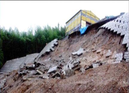
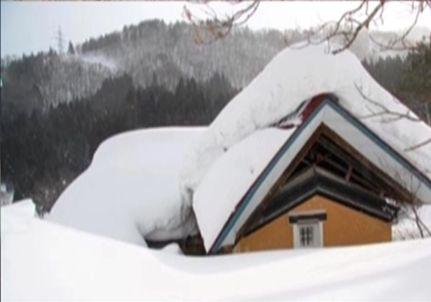
4 Great East Japan Earthquake 3 Occurred on 11 March 2011, 02:46pm Moment Magnitude: 9.0 Maximum Seismic intensity: 7 (Miyagi) Massive tsunami : observed tsunami height (22yards) more than 20m run up of tsunami wave


5 Natural Hazards of Japan 4
6 Disaster Management System

7 Organization of the national government of Japan 6


8 Disaster Management System 7 collectio n analysis evaluatio n disseminatio n
 8 u DIS: Govt")

9 Integrated Disaster Management Information System (DIS) 8 u DIS: Govt Automated Disaster Information Sharing system マスターテキストの書式設定第 2 レベル 第 3 レベル 第 4 レベル 第 5 レベル


10 9 (1) J - ALERT u J-ALERT, a nationwide automated early warning system Municipalities National Government Transmission device artificial satellite Cabinet Secretariat Reception device Receiving antenna Automatically activated municipal disaster administration Wireless Siren System receiver Operation Table Japan in Fire and Disaster Management Agency Meteorologica l Agency Inside building Weather information broadcasting Evacuate! CATV, Community FM, Pager 1-2 seconds In 5-23 seconds Quickly transmits tsunami and other warnings from coast
")
 Broadcastin g")
11 (2) EWBS Automatic Alert EWBS : Emergency Warning Broadcasting System Optional Service for Disaster Alerting Automatically On ISDB-T (Digital TV Standard) Activated Government Alert!!! TSUNAMI Alert Al t er BS W E Japan Meteorological Agency (JMA) Broadcastin g Station Transmitter EWBS-Ready TV Broadcasting Service Area 10


12 How can we disseminate necessary information to the public via EWBS? 11 Broadcasting to mobile devices = One-seg -TV screen with Mobile phone -People can watch TV on Mobile Phone via direct reception EWBS - Automatic switching on = enables to provide necessary info everywhere on real-time basis (even when sleeping midnight ) 12


13 <Policemen saved 40 lives with one-seg mobile TV alarm> 12 Two new policemen saved 40 lives from the train with the tsunami warning alarm from mobile TV(one-seg) right after the earthquake occurred at 14:46 on March 11, They got a tsunami warning alarm from the passengers mobile phone with TV when checking if everyone is fine in the train. They quickly decided to lead the 40 passengers to the hill to avoid the disaster of tsunami. All passengers were safely evacuated from the tsunami area before the tsunami struck the train. Derailed cars of train Route for evacuation Shinchi Station Track of Japan railway Pacific Ocean Shinchi Station Town hall of Shinchi The hill Passengers got on the truck here The cars of train derailed off the track by huge tsunami waves.(march 12, 2011) (Summary from Yomiuri Shimbun(Japanese major national news paper), March 29, 2011)


14 (3) Mobile Alert (Area ) 13 u Mobile EEW/TW Alerting System is quite useful, Especially in countries/regions where mobile penetration ratio is hig This system is for both Mobile phone/smart Phone. Mobile Carriers TSUNAMI Alert Meteorological Agency (JMA) Earthquake Early Warning Tsunami Warning Docomo AU/KDDI Softbank Simultaneous Transmission Alert! Municipal Offices Evacuation Info etc. E-Mobile Area with Alarm & Vibration People can receive Disaster Warning as well as area-specific Information

 Satellite Emergency Mobile")


 And (2)")


15 14 Image of ICT-based Total Disaster Management System Community FM Stations (For Small Area) Satellite Emergency Mobile Network Radio (1) JALERT Related Agencies Meteorologi cal Agency Cabinet Office Public Information Commons Municipal Offices Central Government TV Broadcasting (ISDB-T) And (2) EWBS Cloud-Based Disaster Management Alert TV Broadcasters (NHK, Private) POLICE Emergency Aid INTERNET Various Pubic and Private Websites (3) Mobile Alert EWBS + Data-broadcast Wireless Siren System for EWBS or Simultaneous! BeepRadio Beep! Mobile Phone Carriers One-SEG + EWBS Bee p Bee! p! Beep! Beep! Beep! Beep! Radio Mobile/Cell Alerting Service/Area Mail
16 Key Lessons from Past Experience
 Massive tsunami : observed tsunami height (22yards) more than 20m run up of")
17 reproduced from Great page 3) East Japan Earthquake 16 Occurred on 11 March 2011, 02:46pm Moment Magnitude: 9.0 Maximum Seismic intensity: 7 (Miyagi) Massive tsunami : observed tsunami height (22yards) more than 20m run up of tsunami wave
18 Useful (=life saving) media 17 - based on the survey after the GEJE - 1) Communication with family, friends and relatives - Telecommunications is the first media to try (in vain ) 75% % has no/few connections (because of congestion) - 44% didn t know that fixed line can t be used if there is no electricity - phone voic (storage) services by carriers are quite useful, particularly at post-evacuation period 2) Actual means to get necessary information - TV (fixed) 68%, Radio 39%, Internet 37%, Newspaper 32%, One-seg 20% - The devastated area: TV(fixed) 29%, Radio 66%, One-seg 31% Timeline Forecast / Alert Evacuation /Rescue Tentative Recovery Recovery Measurement


19 Disaster Management 18 - important principle - Information for all Information with speed Information in need Information via diverse and robust networks 19
 Capacity Building of Human Resources - People in charge must be continuously trained and well skilled 3) Daily Preparation and Simulation - Various patterns in disaster case")
20 Key Factors for Disaster Management 19 1) Operation and Maintenance - Even super advanced ICT systems are useless without proper management - Efficient and effective work flows must be pursued among relevant organizations 2) Capacity Building of Human Resources - People in charge must be continuously trained and well skilled 3) Daily Preparation and Simulation - Various patterns in disaster case must be considered in advance - Initiatives such as making hazard maps and disaster drills are useful 4) Recording History - We can learn a lot from past events and histories Miyako City, Miyagi, in
KNOWLEDGE NOTE 3-2. Emergency Communication. CLUSTER 3: Emergency Response. Emergency Communication
 KNOWLEDGE NOTE 3-2 CLUSTER 3: Emergency Response 1 Prepared by Rajib Shaw, Brett Peary, Ai Ideta, and Yukiko Takeuchi, Kyoto University; and Japan s Ministry of Internal Affairs and Communication 2 KNOWLEDGE
Empirical Study on Emergency Broadcasting: Based on the US, UK and Japan s Experience Caixia Zhang 1
 2017 3rd International Conference on Social Science and Technology Education (ICSSTE 2017) ISBN: 978-1-60595-437-0 Empirical Study on Emergency Broadcasting: Based on the US, UK and Japan s Experience
Proposal. ITU/PITA RRS-16 for Asia & Pacific Emergency Communications: The Role of Satellites
 ITU/PITA RRS-16 for Asia & Pacific Emergency Communications: Proposal The Role of Satellites Raquib Masashi PRAMANIK SKY Perfect JSAT Corporation JAPAN 21 September 2016 JSAT Background Largest Satellite
GNSS (GPS) buoy array in the Pacific for natural disaster mitigation. Teruyuki KATO Earthquake Research Institute the University of Tokyo, Japan
 buoy array in the Pacific for natural disaster mitigation. Teruyuki KATO Earthquake Research Institute the University of Tokyo, Japan") GNSS (GPS) buoy array in the Pacific for natural disaster mitigation Teruyuki KATO Earthquake Research Institute the University of Tokyo, Japan 1 (Modified from Oki & Koketsu, 2011) Historical megaquakes
GNSS (GPS) buoy array in the Pacific for natural disaster mitigation Teruyuki KATO Earthquake Research Institute the University of Tokyo, Japan 1 (Modified from Oki & Koketsu, 2011) Historical megaquakes
Securing Access to ICTs in Natural Disasters - Experiences in Japan -
 Securing Access to ICTs in Natural Disasters - Experiences in Japan - FEB 22 2005 Manabu Kanaya Director of Telecommunication Systems Division, Telecommunications ns Bureau, Ministry of Internal Affairs
PUBLIC ALERT: Delivers Emergency All-Hazard Warnings, Everywhere, All the Time
 PUBLIC ALERT: Delivers Emergency All-Hazard Warnings, Everywhere, All the Time DELIVERS EMERGENCY ALL-HAZARD WARNINGS In November 2002, the National Oceanic and Atmospheric Administration (NOAA) and National
(P.27)
") (P.27) 27 7 210 120 8 * Navigation and Anchoring Prohibited Area has been changed since June, 2017. 9 Port of Osaka The Guidelines of Measures for preventing Typhoon Disaster ( Objective )
(P.27) 27 7 210 120 8 * Navigation and Anchoring Prohibited Area has been changed since June, 2017. 9 Port of Osaka The Guidelines of Measures for preventing Typhoon Disaster ( Objective )
Result Report on MDRU Joint Project. March, 2016
 Result Report on MDRU Joint Project March, 2016 Contents 1 1.MDRU Overview 2 2.Joint Project Background 3 3.Joint Project Overview 4 4.Feasibility Study Activities 6 5.Conclusion 15 1. MDRU Overview 2
PADANG. Determination of Hazard from National Level GENERAL INFORMATION
 Determination of Hazard from National Level PADANG Padang with approximately one million citizens is one of the most prawn areas in the world and threatened by possible coming big Earthquakes and Tsunami.
DELIVERING THE INDUSTRY S FIRST DISASTER AND SAFETY AUTOMATIONS
 DELIVERING THE INDUSTRY S FIRST DISASTER AND SAFETY AUTOMATIONS About Us - Only Disaster Automations company in existence with our extensive partnerships and capabilities - Covering 98% of the US population
Emergency Response/Recovery Plan
 Emergency Response/Recovery Plan Revised June 2010 Introduction This document outlines the WGCU Public Media personnel and procedures plan in response to a hurricane or other declared natural disaster.
DELAWARE COUNTY PUBLIC WARNING SYSTEM
 Appendix III-3 DELAWARE COUNTY PUBLIC WARNING SYSTEM Appendix III- 3-1 EMERGENCY ALERT SYSTEM (EAS) PLAN FOR DELAWARE COUNTY, NEW YORK PURPOSE 1. To meet Federal guidelines set down for a plan by each
第 XVII 部 災害時における情報通信基盤の開発
 XVII W I D E P R O J E C T 17 1 LifeLine Station (LLS) WG LifeLine Station (LLS) WG was launched in 2008 aiming for designing and developing an architecture of an information package for post-disaster
GNSS buoy array in the ocean for natural hazard mitigation. Teruyuki KATO Earthquake Research Institute the University of Tokyo, Japan
 GNSS buoy array in the ocean for natural hazard mitigation Teruyuki KATO Earthquake Research Institute the University of Tokyo, Japan 1 GNSS applications in Earth science From static to high-rate observations
Agenda. The disaster cycle. Elements of a community-based warning system*
 Elements of a community-based system* * and its relation to a public system Rohan Samarajiva Presentation at Workshop on Sharing Knowledge 5 March 2008, Jakarta Agenda The disaster cycle and the role of
GEONET -CORS Network of japan-
 GEONET -CORS Network of japan- Basara Miyahara Geospatial Information Authority of Japan Geospatial and GNSS CORS Infrastructure Forum Kuala Lumpur - Malaysia Geospatial Information Authority of Japan
Remote sensing radio applications/ systems for environmental monitoring
 Remote sensing radio applications/ systems for environmental monitoring Alexandre VASSILIEV ITU Radiocommunication Bureau phone: +41 22 7305924 e-mail: alexandre.vassiliev@itu.int 1 Source: European Space
ISDB-T Transmission Technologies and Emergency Warning System
 ISDB-T Seminar Presentation 2 ISDB-T Transmission Technologies and Emergency Warning System 13 14 June, 2007 Bangkok, Thailand JAPAN Koichiro IMAMURA (NHK) Contents 1. ISDB-T System 2. DTTB Implementation
CONSTRUCTION AND OPERATION OF A WORK VESSEL LOCATION AND NAVIGATION INFORMATION SYSTEM FOR FISHING PORT CONSTRUCTION
 CONSTRUCTION AND OPERATION OF A WORK VESSEL LOCATION AND NAVIGATION INFORMATION SYSTEM FOR FISHING PORT CONSTRUCTION by Shimpei Nagano 1, Masaaki Wada 2 (Ph.D.), Shuichi Tanaka 3, Masayuki Fudo 4 and Akira
Advanced Warning Message Distribution Platform for the Next-generation Mobile Communication Network
 SAE Emergency Warning System Area Mail Special Articles on SAE Standardization Technology Advanced Warning Message Distribution Platform for the Next-generation Mobile Communication Network 3GPP Release
Note that some are my own photos, comments, and opinions - Not necessary reflecting WB GFDRR s views
 1 Session 7: The Recovery Process Note that some are my own photos, comments, and opinions - Not necessary reflecting WB GFDRR s views Yuichi Ono Professor, International and Regional Cooperation Office
Datacasting for Public Safety Access to Enhanced Technology via Public Television
 Datacasting for Public Safety Access to Enhanced Technology via Public Television Thursday, January 17, 2019 2:00 3:30 PM Eastern Time Zone Conference Line: (510) 227-1018 Conference ID: 446 1830 Screen
KNOWLEDGE NOTE 5-3. Risk Communication. CLUSTER 5: Hazard and Risk Information and Decision Making. Risk Communication
 KNOWLEDGE NOTE 5-3 CLUSTER 5: Hazard and Risk Information and Decision Making 1 Prepared by Rajib Shaw, Yukiko Takeuchi, and Shohei Matsuura, Kyoto University; and Keiko Saito, World Bank 2 KNOWLEDGE NOTE
SIMULATION OF EARTHQUAKES AND TSUNAMI THROUGH GSM NETWORK
 PROCEEDINGS OF ICETECT 2011 SIMULATION OF EARTHQUAKES AND TSUNAMI THROUGH GSM NETWORK G.SARADHA B.TECH-IT(FINAL YEAR) MOOKAMBIGAI COLLEGE OF ENGINEERING, PUDUKKOTTAI-622 502, TAMILNADU, INDIA. saradhagunasekaran@gmail.com
ITU Radiocommunication Sector (ITU-R) and Climate Change. Alexandre VASSILIEV ITU Radiocommunication Bureau
 and Climate Change. Alexandre VASSILIEV ITU Radiocommunication Bureau") ITU Radiocommunication Sector (ITU-R) and Climate Change Alexandre VASSILIEV ITU Radiocommunication Bureau WSIS FORUM 2009, Geneva, 18-22 May 2009 Radio and Information Society Today radio technologies
ITU Radiocommunication Sector (ITU-R) and Climate Change Alexandre VASSILIEV ITU Radiocommunication Bureau WSIS FORUM 2009, Geneva, 18-22 May 2009 Radio and Information Society Today radio technologies
IPSTAR Disaster Recovery and Emergency Communications
 IPSTAR Disaster Recovery and Emergency Communications March 2009 COPYRIGHT THAICOM PLC 2009 PROPRIETARY Content Introduction 3 Advantages 4 Applications 5 Equipment 6-7 IPSTAR Enterprise Series IPSTAR
Pierce County Comprehensive Emergency Management Plan EMERGENCY SUPPORT FUNCTION 2 COMMUNICATIONS
 EMERGENCY SUPPORT FUNCTION 2 COMMUNICATIONS ESF COORDINATOR Pierce County Department of Emergency Management JOINT PRIMARY AGENCIES Pierce County Department of Emergency Management Pierce County Information
There are not any on site emergency medical facilities in Holberg.
 12.2 HOLBERG Holberg is located on Holberg Inlet which has access to the Pacific Ocean on the west coast of Vancouver Island. Population is approximately 70 persons with the village located mainly at the
New Approach for Tsunami Detection Based on RTK-GNSS Using Network of Ships
 New Approach for Tsunami Detection Based on RTK-GNSS Using Network of Ships Tokyo University of Marine Science and Technology Ryuta Nakaosone Nobuaki Kubo Background After the Indian Ocean Tsunami on 2004,
An ICT for Realizing a Safe and Secure Society
 International Affairs Department, Telecommunications Bureau Vol. 18 No. 5 Biweekly Newsletter of the Ministry of Internal Affairs and Communications (MIC), Japan ISSN 1349-7987 Please feel free to use
Safety and alarming applications using ISA100 Wireless
 Safety and alarming applications using ISA100 Wireless Standards Certification Education & Training Publishing Conferences & Exhibits 11 th November, 2015 Toshi Hasegawa Yokogawa Electric Corporation Presenter
Computers Watching Tsunamis DEEP- O C E A N A S S E S S M E N T A N D R E P O R T I N G ( D A R T I I )
") Computers Watching Tsunamis DEEP- O C E A N A S S E S S M E N T A N D R E P O R T I N G ( D A R T I I ) Origins of Tsunamis 1 Origins of Tsunamis 1 Energy density I(r) in terms of energy, E, and distance,
Computers Watching Tsunamis DEEP- O C E A N A S S E S S M E N T A N D R E P O R T I N G ( D A R T I I ) Origins of Tsunamis 1 Origins of Tsunamis 1 Energy density I(r) in terms of energy, E, and distance,
Emergency Telecommunications initiatives for Disaster Management in Maldives
 Emergency Telecommunications initiatives for Disaster Management in Maldives ITU/ESCAP Disaster Communications Workshop, 12 15 December 2006, Bangkok, Thailand Abdullah Shiham Adam E-mail:- shiham@tam.gov.mv
ESF 2. Communications
 ESF 2 Communications This page left blank intentionally. 1 Introduction: Purpose and Scope ESF 2 organizes, establishes, and maintains the communications capabilities among appropriate agencies/entities
"Gensai Communication System": Development of the terminal device
 "Gensai Communication System": Development of the terminal device Yasuhiko Yotsuyanagi, Tadashi Fueki, Kazuyuki Toko, Nobukazu Teraoka, Ayuchi Kurosu [Summary] We developed Gensai Communication System
MARITIME SAFETY INFORMATION
 Introduction 1. Maritime Safety Information (MSI) is defined as navigational and meteorological warnings, meteorological forecasts, and other urgent safety-related messages. This information is of vital
Emergency Support Function 2. Communications. Iowa County Emergency Management Agency
 Emergency Support Function 2 Communications ESF Coordinator: Iowa County Emergency Management Agency Primary Agencies: Iowa County Communications E 9-1-1 Center Support Agencies: Iowa County Emergency
Application of Satellite Communication System to Tsunami Early Warning System Satoru Ozawa
 Application of Satellite Communication System to Tsunami Early Warning System Satoru Ozawa Space Applications Program Systems Engineering Office Space Applications Mission Directorate Japan Aerospace Exploration
GNSS and M2M for Automated Driving in Japan Masao FUKUSHIMA SIP Sub-Program Director ITS Technical Consultant, NISSAN MOTOR CO.,LTD May. 15.
 ICT SPRING EUROPE 2018 GNSS and M2M for Automated Driving in Japan Masao FUKUSHIMA SIP Sub-Program Director ITS Technical Consultant, NISSAN MOTOR CO.,LTD May. 15. 2018 SIP : Cross-Ministerial Strategic
ITS Radiocommunications in Japan Progress report and future directions
 ITS Radiocommunications in Japan Progress report and future directions 6 March 2018 Berlin, Germany Tomoaki Ishii Assistant Director, New-Generation Mobile Communications Office, Radio Dept., Telecommunications
Short and Long Term Partnering Strategies for Improving Communications/Disseminatio ns for Pacific Island NMHSs
 Short and Long Term Partnering Strategies for Improving Communications/Disseminatio ns for Pacific Island NMHSs Edward H. Young, Jr. NOAA National Weather Service Pacific Region RANET Pacific Steering
Regional Tsunami Seminars 2013
 Regional Tsunami Seminars 2013 PROGRAMME 1. Review of Tsunami Hazard in New Zealand 2013 Update: Dr William Power 2. Tsunami warning in New Zealand Process: David Coetzee; Dr Ken Gledhill 3. Sirens standard
ITU-T. FG-DR&NRR Version 1.0 (05/2014) Overview of Disaster Relief Systems, Network Resilience and Recovery
 Overview of Disaster Relief Systems, Network Resilience and Recovery") I n t e r n a t i o n a l T e l e c o m m u n i c a t i o n U n i o n ITU-T TELECOMMUNICATION STANDARDIZATION SECTOR OF ITU FG-DR&NRR Version 1.0 (05/2014) ITU-T Focus Group on Disaster Relief Systems,
I n t e r n a t i o n a l T e l e c o m m u n i c a t i o n U n i o n ITU-T TELECOMMUNICATION STANDARDIZATION SECTOR OF ITU FG-DR&NRR Version 1.0 (05/2014) ITU-T Focus Group on Disaster Relief Systems,
Section 2 Council for Science and Technology Policy
 Section 2 Council for Science and Technology Policy The Council for Science and Technology Policy (CSTP) is placed in the Cabinet Office as a council for key policy for vigorously promoting Japan s S&T
THE BEST FIT DIGITAL TELEVISION STANDARD FOR THE PHILIPPINES
 ISDB T (Integrated Services Digital Broadcast Terrestrial) THE BEST FIT DIGITAL TELEVISION STANDARD FOR THE PHILIPPINES October 10, 2008 James Rodney P. Santiago Consultant ARIB/Digital Broadcast Experts
2 ESF 2 Communications
 2 ESF 2 Communications THIS PAGE LEFT BLANK INTENTIONALLY ESF 2 Communications Table of Contents 1 Purpose and Scope... ESF 2-1 2 Policies and Agreements... ESF 2-1 3 Situation and Assumptions... ESF 2-1
A State Toolkit for Adopting IPAWS
 A State Toolkit for Adopting IPAWS The State Toolkit for adopting IPAWS supports State emergency management officials communications, with county and local officials and the people they serve, about the
The Future in Marine Radio Communication GMDSS. Department of Transportation United States Coast Guard
 The Future in Marine Radio Communication GMDSS Department of Transportation United States Coast Guard Do you use a Maritime Radio System? If so, the new Global Maritime Distress and Safety System (GMDSS)
Communication platform for disaster response
 Communication platform for disaster response Mihoko Sakurai University of Agder, Kristiansand, Norway mihoko.sakurai@uia.no Abstract. The present research proposes an information platform for enhanced
ITS radiocommunications toward automated driving systems in Japan
 Session 1: ITS radiocommunications toward automated driving systems in Japan 25 March 2015 Helmond, the Netherland Takahiro Ueno Deputy Director, New-Generation Mobile Communications Office, Radio Dept.,
BookletChart. Sacramento River Sacramento to Fourmile Bend NOAA Chart A reduced-scale NOAA nautical chart for small boaters
 BookletChart Sacramento River Sacramento to Fourmile Bend NOAA Chart 18664 A reduced-scale NOAA nautical chart for small boaters When possible, use the full-size NOAA chart for navigation. Included Area
5-3 JJY, The National Standard on Time and Frequency in Japan
 5-3 JJY, The National Standard on Time and Frequency in Japan The Communications Research Laboratory (CRL) determines the national standard time and frequency in Japan, which is disseminated throughout
JCG GMDSS Symposium NAVDAT : Navigational Data
 JCG GMDSS Symposium 2013 NAVDAT : Navigational Data - System Presentation - Pascal OLIVIER NAVDAT Presentation Page 1/35 From analog to digital in maritime radio communications The current analog radio
Current Situation of Spectrum Use in Japan. June 2018 Ministry of Internal Affairs and Communications
 Current Situation of Spectrum Use in Japan June 2018 Ministry of Internal Affairs and Communications Below 3000kHz Standard Frequency and Time Signal (40kHz/60kHz) Maritime Beacon / DGPS 285 325 Maritime
457 APR The Fourth Medium to Long-term Plan has started. No.
 457 APR 2016 No. The Fourth Medium to Long-term Plan has started We are sorry to inform you that this April 2016 issue will be the final one to be distributed in printed materials. It would be appreciated
The Common Alerting Protocol (CAP) Standard: Worldwide Applications
 Standard: Worldwide Applications") The Common Alerting Protocol (CAP) Standard: Worldwide Applications Presented 19 May 2011 in Venice, Italy by Francesco Gaetani for the 2nd International Conference on Interoperability
The Common Alerting Protocol (CAP) Standard: Worldwide Applications Presented 19 May 2011 in Venice, Italy by Francesco Gaetani for the 2nd International Conference on Interoperability
Radiocommunications and climate changes
 Radiocommunications and climate changes Durban, South Africa 1 December 2011 COP-17 Vadim Nozdrin, Counselor, ITU-R Study Group 7 Study Group Department Radiocommunication Bureau
Nonconventional Technologies Review no. 3/2011
 NONCONVENTIONAL APPLICATIONS OF THE RADIO DATA SYSTEM Alin GROZA Politehnica University of Timisoara, Romania Elena GROZA Regele Ferdinand I High school Timisoara, Romania ABSTRACT: The widespread use
The U.S. West Coast and Alaska Tsunami Warning Center
 ITS 2001 Proceedings, NTHMP Review Session, Paper R-23 229 The U.S. West Coast and Alaska Tsunami Warning Center Thomas J. Sokolowski West Coast and Alaska Tsunami Warning Center, Palmer, Alaska, U.S.A.
ITU and ITU-R Vadim Nozdrin Study Group Department Radiocommunication Bureau
 ITU and ITU-R Vadim Nozdrin Study Group Department Radiocommunication Bureau International Telecommunication Union ITU Facts Founded in 1865 193 Member States > 700 Sector members > 100 Academies 4 regional
Use of Satellite Remote Sensing in Tsunami Damage Assessment
 Japan-Peru Workshop on Earthquake Disaster Mitigation, Lima 2005 Use of Satellite Remote Sensing in Tsunami Damage Assessment August 10, 2005 Fumio Yamazaki Chiba University, Chiba, Japan 1 World Tsunami
Internet : During & Post
 Internet : During & Post Disaster B A B U R A M A R Y A L P R E S I D E N T, I N T E R N E T S O C I E T Y N E P A L 25 th April 2015 Barpak Gorkha 7.8 Richter Scale 12 th May 2015 Kodari, Sindhupalchowk
Current Status of ITS Radiocommunications in Japan
 Session 2: How do standards match the planned day one deployment? Current Status of ITS Radiocommunications in Japan 5 February 2013 Vienna, Austria Hiroki Taniguchi Deputy Director, Land Mobile Communications
Addressable Radios for Emergency Alert (AREA): WorldSpace Satellite Radio
: WorldSpace Satellite Radio") Addressable Radios for Emergency Alert (AREA): A WorldSpace solution for effective delivery of alerts S.Rangarajan, Jerome Soumagne and Jean-Luc Vignaud WorldSpace Satellite Radio srangarajan@worldspace.com,
Addressable Radios for Emergency Alert (AREA): A WorldSpace solution for effective delivery of alerts S.Rangarajan, Jerome Soumagne and Jean-Luc Vignaud WorldSpace Satellite Radio srangarajan@worldspace.com,
1.Earthquake Early Warning System. Japan Meteorological Agency
 1 st Process 1.Earthquake Early Warning System Estimation Estimation of of Hypocenter, Hypocenter, Magnitude Magnitude and and Seismic Seismic Intensity Intensity Dissemination Dissemination 2. 2. Present
NEDO s Activities in the Robotics and Artificial Intelligence Fields
 NEDO s Activities in the Robotics and Artificial Intelligence Fields November 29, 2017 Dr. Shuji Yumitori Director General, Robot and Artificial Intelligence Technology Department New Energy and Industrial
BHN's Engagement in Disaster Risk Reduction. Supporting Activities and Human Resource Development for Disaster Risk Reduction
 The Third UN World Conference on Disaster Risk Reduction BHN's Engagement in Disaster Risk Reduction Supporting Activities and Human Resource Development for Disaster Risk Reduction March 14, 2015 Approved
This document is downloaded from DR-NTU, Nanyang Technological University Library, Singapore.
 This document is downloaded from DR-NTU, Nanyang Technological University Library, Singapore. Title Radio : due for another renaissance Author(s) P. S. Sundaram Citation P. S. Sundaram. (1998). Radio :
Building Sustainable and Resilient Communities
 2015/SOM1/EPWG/032 Agenda Item: 8.6 Building Sustainable and Resilient Communities Purpose: Information Submitted by: China 7 th Emergency Preparedness Working Group Meeting Subic, Philippines 28-29 January
Meeting 10 8 August 2018 Agenda Item 2.1. MSI Self Assessment NAVAREA XVI. Submitted by PERÚ - DIRECTORATE OF HYDROGRAPHY AND NAVIGATION SUMMARY
 WWNWS10 WWNWS10/2/1-XVI Meeting 10 8 August 2018 Agenda Item 2.1 MSI Self Assessment NAVAREA XVI Submitted by PERÚ - DIRECTORATE OF HYDROGRAPHY AND NAVIGATION SUMMARY Executive Summary: Report of activities
Digital Radio in the car in 10 years
 Digital Radio in the car in 10 years 2017/06/21 D.Brion - Project Manager - Clarion Europe SAS 1 Media evolution in the car The first car radio appears in the 20 s but evolution is very slow, receiver
IPReady. EAS CAP doesn t get any easier. Ka You
 IPReady. EAS CAP doesn t get any easier. Who is Communications? Leading provider of broadcast satellite solutions Serving radio and TV broadcasters nationwide Customer base Group-owned and operated networks
BookletChart. Chesapeake Bay Pocomoke and Tangier Sounds NOAA Chart A reduced-scale NOAA nautical chart for small boaters
 BookletChart Chesapeake Bay Pocomoke and Tangier Sounds NOAA Chart 12228 A reduced-scale NOAA nautical chart for small boaters When possible, use the full-size NOAA chart for navigation. Published by the
WWNWS9/3/2/XVI/Rev.1 Meeting 9 22 August 2017 Agenda Item 3.2. MSI Self Assessment NAVAREA XVI. Submitted by
 WWNWS9 WWNWS9/3/2/XVI/Rev.1 Meeting 9 22 August 2017 Agenda Item 3.2 MSI Self Assessment NAVAREA XVI Submitted by PERÚ - DIRECTORATE OF HYDROGRAPHY AND NAVIGATION SUMMARY Executive Summary: Report of activities
XV. MITRE Corporation
 XV. MITRE Corporation A. General Information The MITRE Corporation, established in 1958, is a not-for-profit organization which conducts work in systems engineering, information technology, operational
DAB EWF Emergency Warning & Alert Functionality
 DAB EWF Emergency Warning & Alert Functionality DAB Tools, Features and Considerations 2014-06-14 DAB Workshop @ itvf, Istanbul Dipl.-Ing. Bernd Linz Fraunhofer IIS Broadcast Applications bernd.linz@iis.fraunhofer.de
WR120 Owner s Manual Guide du propriétaire Manual de instrucciones
 WR120 Owner s Manual Guide du propriétaire Manual de instrucciones Midland Radio Corporation 5900 Parretta Drive Kansas City, MO 64120 Tel. (816) 241-8500 All Hazards Alert Weather Radio with S.A.M.E Quick
Virginia s IFLOWS System and Future Approaches to Dam Safety
 Virginia s IFLOWS System and Future Approaches to Dam Safety Sam Utley Division Manager, Environmental Monitoring Services 3154 State Street, Blacksburg, VA 24060 PH: 540-961-7894 x427 March 10, 2008 MapTech
Glossary of Terms Black Sky Event: Blue Sky Operations: Federal Communications Commission (FCC): Grey Sky Operations:
: Grey Sky Operations:") Glossary of Terms The following is a list of terms commonly used in the electric utility industry regarding utility communications systems and emergency response. The purpose of this document is to provide
Glossary of Terms The following is a list of terms commonly used in the electric utility industry regarding utility communications systems and emergency response. The purpose of this document is to provide
EFFECTIVE DATE: 01/01/2002 REFERENCES: RELATED DIRECTIVES: RESCINDS:
 DIVISION: Communications DATE OF ISSUE: 01/01/2002 EFFECTIVE DATE: 01/01/2002 NO: Section 7 SUBJECT: PAGING SYSTEM DISTRIBUTION: AMMENDS: REFERENCES: RELATED DIRECTIVES: RESCINDS: POLICY STATEMENT: The
BookletChart. Sacramento River Andrus Island to Sacramento NOAA Chart A reduced-scale NOAA nautical chart for small boaters
 BookletChart Sacramento River Andrus Island to Sacramento NOAA Chart 18662 A reduced-scale NOAA nautical chart for small boaters When possible, use the full-size NOAA chart for navigation. Included Area
A Preliminary Integrated Tsunami Scenario Simulation. Toshitaka KATADA
 Workshop for Integrated Tsunami Scenario Simulation at OSU August 8,2003 A Preliminary Integrated Tsunami Scenario Simulation Toshitaka KATADA Department of civil engineering, Gunma Univ. Research Field:
This document is downloaded from DR-NTU, Nanyang Technological University Library, Singapore.
 This document is downloaded from DR-NTU, Nanyang Technological University Library, Singapore. Title Country report : media in the Lao PDR Author(s) Citation Country report : media in the Lao PDR. (2000).
Telematics COLOMBIAN RED CROSS
 Telematics COLOMBIAN RED CROSS LEGAL FRAMEWORK Act 49 of 1948 Through which is created the National Relief of the Colombian Red Cross in case of Public Calamity. LEGAL FRAMEWORK Through resolution No.
Controls. LCD display A B C D E F
 H205 Version 1 1 2 3 4 5 6 13 12 11 7 8 9 10 14 15 17 18 16 1 19 Controls 1 2 3 4 5 6 7 8 9 10 11 12 13 14 15 16 17 18 19 Carrying strap holder Preset 1 Preset 2 Preset 3/STEP button Preset 4 LCD display
Introduction to Common Alerting Protocol (CAP)
") World Meteorological Organization (WMO) Observing and Information Systems Department WMO Information System (WIS) Introduction to Common Alerting Protocol (CAP) Prepared by Eliot Christian
World Meteorological Organization (WMO) Observing and Information Systems Department WMO Information System (WIS) Introduction to Common Alerting Protocol (CAP) Prepared by Eliot Christian
Himawari-8 and AOMSUC-6. Toshihiko HASHIDA Japan Meteorological Agency (JMA)
") Himawari-8 and AOMSUC-6 Toshihiko HASHIDA Japan Meteorological Agency (JMA) Side Event on Communication to Members of RA II and RA V on the outcomes and future plans of AOMSUCs, 3 June 2015 Dawn of a New
Himawari-8 and AOMSUC-6 Toshihiko HASHIDA Japan Meteorological Agency (JMA) Side Event on Communication to Members of RA II and RA V on the outcomes and future plans of AOMSUCs, 3 June 2015 Dawn of a New
EMERGENCY SUPPORT FUNCTION #2 COMMUNICATIONS
 COORDINATING AGENCY PRIMARY AGENCIES: Guernsey County Emergency Management Agency Guernsey County Sheriff s Office Cambridge Police Department SUPPORT AGENCIES: I. Introduction Guernsey County Fire Departments
Satellite Regulatory Framework in Japan
 ITU International Satellite Symposium 2015 30 September 1 October 2015 Danang City, Vietnam M I C Satellite Regulatory Framework in Japan Haruko S. TAKESHITA Assistant Director Ministry of Internal Affairs
BookletChart. Intracoastal Waterway Grassy Key to Bahia Honda Key NOAA Chart A reduced-scale NOAA nautical chart for small boaters
 BookletChart Intracoastal Waterway Grassy Key to Bahia Honda Key NOAA Chart 11453 A reduced-scale NOAA nautical chart for small boaters When possible, use the full-size NOAA chart for navigation. Published
Engineering Project Proposals
 Engineering Project Proposals (Wireless sensor networks) Group members Hamdi Roumani Douglas Stamp Patrick Tayao Tyson J Hamilton (cs233017) (cs233199) (cs232039) (cs231144) Contact Information Email:
Royal Canadian Mounted Police Port Hardy Detachment There are no on-site emergency medical facilities in Holberg.
 PART 4.3 HOLBERG 4.3.1 Overview Holberg is located on Holberg Inlet which has access to the Pacific Ocean on the west coast of Vancouver Island. Population is approximately 100 persons, with the village
Communications and Warning Annex C. County of Kings. Communication & Warning Annex. November County of Kings EOP, 2013 Page 1
 C County of Kings Communication & Warning Annex November 2015 County of Kings EOP, 2013 Page 1 Table of Contents INTRODUCTION... 3 PURPOSE... 3 COMMUNICATION SYSTEMS... 3 COMMUNICATION SYSTEMS VULNERABILITIES...
inetvu : Earthquake-Proven
 A C-COM Satellite Systems Inc. White Paper 2574 Sheffield Road Ottawa, ON K1B 3V7 613-745-4110 www.c-comsat.com inetvu : Earthquake-Proven By Paul Seguin, Satellite Application Specialist Date April 27,
Japanese Candidate for Election to ITU's Radio Regulations Board
 International Policy Division, Global ICT Strategy Bureau Vol. 20 No. 24 Biweekly Newsletter of the Ministry of Internal Affairs and Communications (MIC), Japan ISSN 1349-7987 Please feel free to use the
SHARE, the Next Step for Nature Industry Revolution
 Workshop SHARE, the Next Step for Nature Industry Revolution Yuji INOUE Toyota Info-Technology Center yuji@m.ieice.org Yuji 8 April, 2016 SHARE; Nature Industry Revolution by Yuji Inoue all rights in Toyota
Features:...2 Installing the back-up Batteries:...2 Connecting AC Power:...2 Connecting an External Antenna:...3 Connecting the Weather Radio to an
 Features:...2 Installing the back-up Batteries:...2 Connecting AC Power:...2 Connecting an External Antenna:...3 Connecting the Weather Radio to an External System:...3 Location of the Weather Radio:...3
Software Defined Radio. Listening to the Bleeps and Bloops around you
 Software Defined Radio Listening to the Bleeps and Bloops around you Software Defined Radio in a nutshell Like a FM radio, but can receive a wider radio spectrum range Quick Peek at Radio Frequencies
Introduction and Methodology Rural Targeted Assessments and Snapshot
 Introduction and Methodology Rural Targeted Assessments and Snapshot The Rural Targeted Assessments are intended only as educational materials for station use. The analysis results are derived from data
Emerging technology could positively impact all phases of emergency management. CUTTING EDGE
 CUTTING Emerging technology could positively impact all phases of emergency management. EDGE Albert Einstein once said: The true sign of intelligence is not knowledge but imagination. Who can argue with