Nigerian Communications Satellite Ltd. (NIGCOMSAT)
|
|
|
- Julius Rice
- 6 years ago
- Views:
Transcription

1 OVERVIEW OF NIGERIAN SATELLITE AUGMENTATION SYSTEM COMMENCING WITH PILOT DEMONSTRATION TO VALIDATE NATIONAL WORK PLAN presented by Dr. Lawal Lasisi Salami, NIGERIAN COMMUNICATIONS SATELLITE LTD UNDER FEDERAL MINISTRY OF COMMUNICATIONS OF ITU RESOLUTION-609 CONSULTATION MEETING IN AUCKLAND,NEW ZEALAND. Nigerian Communications Satellite Ltd. (NIGCOMSAT)
2 Outline About NIGCOMSAT Ltd NigComSat 1R Hybrid COMSAT and Coverage Introduction to Global Navigation Satellite System (GNSS) Needs Assessment for Augmentation Systems Regional Satellite Based Augmentation System (SBAS) across the world (Operational and Planned). Illustration of Regional Satellite Based Augmentation System NIGCOMSAT-1R NAVIGATION PAYLOAD: Africa s Contribution to SBAS and Global Navigation Satellite System (GNSS). Relevance, Envisaged NigComSat-1R L-Band Applications & Economic Importance
3
4 About NIGCOMSAT Ltd The Nigerian Communications Satellite (NIGCOMSAT) LTD is a Government owned agency under Federal Ministry of Communications.
5 About NIGCOMSAT Ltd The company operates and manages geostationary communications satellite; NigComSat-1,NigComSat- 1R. Our mission is to provide ubiquitous connectivity and communication satellite solutions through innovation Our vision is to be the leading communications satellite solution provider in Nigeria and indeed Africa.
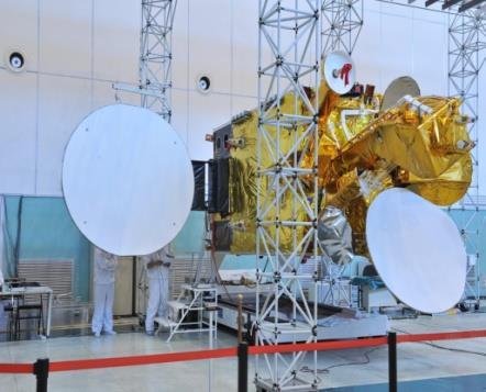
6 About NIGCOMSAT-1(R) Nigeria s first communication satellite (NIGCOMSAT-1), a quad-band high powered satellite with navigational capability and capacity launched on 14th May, NIGCOMSAT-1 was Africa s first contribution to the Global Navigation Satellite System as regional Satellite-based Augmentation System (SBAS). It was however de-orbited on the 10th of November, 2008 due to an irreparable single point of failure on-board the satellite. All broadcast, telecommunication services being offered by the satellite including strategic navigational plans and objectives were disrupted. The NIGCOMSAT-1R, is the replacement for NIGCOMSAT-1 satellite launched on 19 th December, 2011.


7 NigComSat-1R West antenna subreflector C-band communication antenna Ku-band west antenna C-band navigation antenna Ka-band receive antenna Earth sensor Ka-band transmit antenna East antenna sub-reflector L-band navigation antenna Ku-band East antenna
8 8
9 9 NIGCOMSAT S GROUND INFRASTRUCTURES DIRECTORATES SATELLITE CONTROL & OPERATIONS SATELLITE APPLICATIONS AND DEVELOPMENT

10 Satellite Control & Ops (Satellite control) Uninterrupted tracking satellite Receiving, processing, monitoring and store real time telemetry Processing and sending tele-command Monitoring satellite status on real time Managing satellite platform Satellite attitude control Satellite special management during eclipse season Inhibition protection to the sensors and detectors Managing EPS subsystem Managing TCS subsystem Satellite health check 10


11 Satellite Control & Ops (Network Operations) 11
12 SOME EXISTING GNSS 12 Other GNSS are as presented in the table below: System No. of Satellites Nominal Altitude (Km) Orbit Inclination i (º) Initiation and Current Operational Capability GPS 30 (5 th Feb. 2016) 20, Initiated 1973 by USA, 1995(FOC) GLONASS 24 (29 th May 2016) 19, Initiated by Russia in 1975, 1996(FOC) 2011 (Restarted Modernization) GALILEO Presently 14 satellites (24 th May 2016) (30) 24, Initiated by EU in 2000, 2014(IOC) 2020(FOC) tentatively BEIDOU (COMPASS) Presently 23 (13th June, 2016) (30) 30 MEO Satellites (21,500) 5 IGSO Satellites inclined at 55 degrees 55 Initiated by China in 1990s. Regional System declared operational in (FOC)
13 Needs Assessment for Augmentation Systems 13 Satellite-Based Augmentation System (SBAS) arose from the need to provide continuity, Availability, Integrity and Accuracy of GPS signals to eliminate errors and compensate for discrepancies associated with GPS signals and other navigation systems. An augmentation system can be Ground-Based (GBAS) or Satellite-Based (SBAS) and arises from the need to provide continuity, availability, integrity and accuracy of Global positioning signals to eliminate errors and compensate for discrepancies associated with GPS signals as well as fleet management capability. Augmentation is important in applications that involve safety of life, i.e all phases of flight, which requires improved accuracy of the global positioning signals to eliminate errors and compensate for discrepancies through differential corrections associated with GPS signals and other navigation systems in terms of positioning, velocity and timing requirements of aviation, maritime and land-based transport systems. The most effective augmentation system, especially for coverage capability, is the Satellite-Based Augmentation System (SBAS), which transmits signals over a wide
14 REGIONAL SATELLITE BASED AUGMENTATION SYSTEM (SBAS) ACROSS THE WORLD (OPERATIONAL AND PLANNED). a. USA: Wide Area Augmentation System (WAAS), expanded to Canada as CWAAS and planned expansion to South America. b. Europe: European Geostationary Navigation Overlay System (EGNOS) with planned expansion over Africa. c. China: Chinese Satellite Navigation Augmentation System (SNAS) currently DRAGON: Differential Reference Augmentation Global Overlay Network. d. Japan: MTSAT Satellite Augmentation System (MSAS). MTSAT means Multi-functional Transport SATellite. e. India: GPS-Aided Geo-Augmented Navigation (GAGAN). f. Russian Federation: System Differential Correction and Monitoring (SDCM). g. AFRICA: Nigerian Satellite Augmentation System (NSAS)

15 ILLUSTRATION OF REGIONAL SATELLITE BASED AUGMENTATION SYSTEM. WAAS: US Wide Area Augmentation System EGNOS: European Geostationary Navigation Overlay Service MSAS: Japanese MTSAT Satellite Augmentation SystemSNAS: Chinese Satellite Navigation Augmentation System CWAAS: Canadian Wide Area Augmentation System
.")

16 NIGCOMSAT-1R NAVIGATION PAYLOAD: AFRICA S CONTRIBUTION TO SBAS AND GLOBAL NAVIGATION SATELLITE SYSTEM (GNSS). 10MHz ultra stable crystal oscillator was used for the L-band payload to meet the performance requirements of frequency conversion stability and accuracy.

17 NIGCOMSAT-1R NAVIGATION PAYLOAD: AFRICA S CONTRIBUTION TO SBAS AND GLOBAL NAVIGATION SATELLITE SYSTEM (GNSS). The downlink coverage beam of NIGCOMSAT-1R Geo-Navigation Satellite using L Band Helix Antenna. NIGCOMSAT Master Control Station with C-L Band Antenna Systems
.")
")
18 NIGCOMSAT-1R NAVIGATION PAYLOAD: AFRICA S CONTRIBUTION TO SBAS AND GLOBAL NAVIGATION SATELLITE SYSTEM (GNSS). The downlink coverage beam of NIGCOMSAT-1R Geo-Navigation Satellite on L1 Frequency The downlink coverage beam of NIGCOMSAT-1R Geo-Navigation Satellite on L5 Frequency Channel Frequency (MHz) Polarization Bandwidth (MHz) L1-Downlink RHCP 4 L5-Downlink RHCP 20
19 19 RELEVANCE, ITS ENVISAGED APPLICATIONS AND ECONOMIC IMPORTANCE
 and Nigerian Airspace Management Authority (NAMA) to ensure demonstration meets ICAO requirements and standards and thus certification")
20 Aviation Increased Runway Access More direct en route flight paths New precision approach services Reduced and simplified equipment on board aircraft Working currently with Ministry of State, Aviation, Nigerian Civil Aviation Authority (NCAA) and Nigerian Airspace Management Authority (NAMA) to ensure demonstration meets ICAO requirements and standards and thus certification thereafter.

21 Maritime Ocean navigation Port approaches Restricted waters guidance Auto docking Working with Ministry of Transportation currently.

22 Train Transportation Automatic tracking and inspections. The prevention of collisions, derailments, work zone incursions, and rail switch errors. Automatic speed control / braking The increasing of capacity and efficiency for all rail users. Position control, loading and unloading operations
23 Civil Engineering/GIS Land Surveying Land Slide GIS Collection Precision Agriculture Deformation Monitoring For the high precision applications, the GNSS/SBAS terminals with sub-meter level position accuracy can be used for land surveying, slide,


24 Road Transportation Vehicle Tracking, Fleet management and Integration with GIS systems Demographic Information etc. Good tracking Traffic Management Vehicle charging Intelligent transport
25 OTHER AMBITIOUS SBAS/GNSS APPLICATIONS ARE: Security of National Infrastructure: Pipelines, Power Lines and Strategic National Infrastructure. Improved Agricultural Practice with high yield. Improved Emergency Services, Recovery Services, Search & Rescue. Utility Management: Energy and Communications Company for synchronization. Geographic Information System Companies Tourism Telematic Services i.e Insurance Companies Environmental Protection, Characterization and Demography Public Safety: Tall Buildings, Bridges etc Scientific Research
 INDICATOR SUMMARY")
26 GLOBAL 2015 SATELLITE INDUSTRY ASSOCIATION (SIA) INDICATOR SUMMARY REPORT

27 Market for Satellite Navigation
28 URGENT NEED FOR ASSIGNMENT OF PRN CODE BY USA FAA 28 ABOUT TEMPORARY PRN 158(NIGCOMSAT-1G DE-ORBITED) WE NEED AT LEAST TEMPORARY PRN CODE ASSIGNMENT FOR NIGCOMSAT-1R TO EXPLOIT ITS NAVIGATION BAND RESOURCE FOR SOCIO-ECONOMIC DEVELOPMENT OF NIGERIA. WE REQUIRE THE SUPPORT OF US DELEGATION PARTICULARLY US FAA.

29 29
GBAS FOR ATCO. June 2017
 GBAS FOR ATCO June 2017 Disclaimer This presentation is for information purposes only. It should not be relied on as the sole source of information, and should always be used in the context of other authoritative
European Geostationary Navigation Overlay Service (EGNOS) Capability on Sirius 5 Satellite for SES
 Capability on Sirius 5 Satellite for SES") 21 October 2009 SES SIRIUS European Geostationary Navigation Overlay Service (EGNOS) Capability on Sirius 5 Satellite for SES Mike Pavloff, Executive Director, Space Systems/Loral Information included
21 October 2009 SES SIRIUS European Geostationary Navigation Overlay Service (EGNOS) Capability on Sirius 5 Satellite for SES Mike Pavloff, Executive Director, Space Systems/Loral Information included
ENHANCING PUBLIC SAFETY AND SECURITY OF CRITICAL NATIONAL INFRASTRUCTURE UTILIZING THE NIGERIAN SATELLITE AUGMENTATION SYSTEM (NSAS)
") ENHANCING PUBLIC SAFETY AND SECURITY OF CRITICAL NATIONAL INFRASTRUCTURE UTILIZING THE NIGERIAN SATELLITE AUGMENTATION SYSTEM (NSAS) LAWAL LASISI SALAMI & CHRIS R. CHATWIN NIGERIAN COMMUNICATIONS SATELLITE
ENHANCING PUBLIC SAFETY AND SECURITY OF CRITICAL NATIONAL INFRASTRUCTURE UTILIZING THE NIGERIAN SATELLITE AUGMENTATION SYSTEM (NSAS) LAWAL LASISI SALAMI & CHRIS R. CHATWIN NIGERIAN COMMUNICATIONS SATELLITE
Challenges and Solutions for GPS Receiver Test
 Challenges and Solutions for GPS Receiver Test Presenter: Mirin Lew January 28, 2010 Agenda GPS technology concepts GPS and GNSS overview Assisted GPS (A-GPS) Basic tests required for GPS receiver verification
SATELLITE BASED AUGMENTATION SYSTEM (SBAS) FOR AUSTRALIA
 FOR AUSTRALIA") SATELLITE BASED AUGMENTATION SYSTEM (SBAS) FOR AUSTRALIA AN AIN POSITION PAPER SUBMITTED TO VARIOUS GOVERNMENT DEPARTMENTS BY MR KYM OSLEY AM, CSC, EXEC SECRETARY AIN What are GNSS Augmentation Systems?
SATELLITE BASED AUGMENTATION SYSTEM (SBAS) FOR AUSTRALIA AN AIN POSITION PAPER SUBMITTED TO VARIOUS GOVERNMENT DEPARTMENTS BY MR KYM OSLEY AM, CSC, EXEC SECRETARY AIN What are GNSS Augmentation Systems?
Lecture-1 CHAPTER 2 INTRODUCTION TO GPS
 Lecture-1 CHAPTER 2 INTRODUCTION TO GPS 2.1 History of GPS GPS is a global navigation satellite system (GNSS). It is the commonly used acronym of NAVSTAR (NAVigation System with Time And Ranging) GPS (Global
The topic we are going to see in this unit, the global positioning system, is not directly related with the computer networks we use everyday, but it
 The topic we are going to see in this unit, the global positioning system, is not directly related with the computer networks we use everyday, but it is indeed a kind of computer network, as the specialised
CONSIDERATIONS FOR GNSS MEASUREMENTS
 CONSIDERATIONS FOR GNSS MEASUREMENTS Cornel PĂUNESCU 1, Cristian VASILE 2, Cosmin CIUCULESCU 3 1 PhD University of Bucharest, e-mail: cornelpaun@gmail.com 2 Lecturer PhD University of Craiova, cristi_vasile_4you@yahoo.com
Aviation Benefits of GNSS Augmentation
 Aviation Benefits of GNSS Augmentation Workshop on the Applications of GNSS Chisinau, Moldova 17-21 May 2010 Jeffrey Auerbach Advisor on GNSS Affairs Office of Space and Advanced Technology U.S. Department
Status of the European EGNOS and Galileo Programmes. Frank Udnaes Galileo policy and Infrastructure group EC DG-TREN. June 2008
 Status of the European EGNOS and Galileo Programmes Frank Udnaes Galileo policy and Infrastructure group EC DG-TREN EUROPEAN COMMISSION z June 2008 Galileo An infrastructure 30 satellite Constellation
SPECIAL EFFECTS OF THE REGIONAL SATELLITE AUGMENTATION SYSTEM (RSAS)
") St. D. Ilcev (Mangosuthu University of Technology (MUT) South Africa) SPECIAL EFFECTS OF THE REGIONAL SATELLITE AUGMENTATION SYSTEM (RSAS) This paper introduces the special effects of the new developed
St. D. Ilcev (Mangosuthu University of Technology (MUT) South Africa) SPECIAL EFFECTS OF THE REGIONAL SATELLITE AUGMENTATION SYSTEM (RSAS) This paper introduces the special effects of the new developed
PRELIMINARY PROGRAMME
 ICG EXPERTS MEETING: GLOBAL NAVIGATION SATELLITE SYSTEMS SERVICES 14-18 December 2015 Vienna International Centre, Vienna, Austria Organized by International Committee on Global Navigation Satellite Systems
ASSEMBLY 37TH SESSION
 International Civil Aviation Organization WORKING PAPER A37-WP/195 1 22/9/10 (Information paper) ASSEMBLY 37TH SESSION TECHNICAL COMMISSION Agenda Item 35: The Global Air Traffic Management (ATM) System
Protection Augmentation Toughness and Alternatives of GNSS. Melaha 2016 Concord Al-Salam Hotel Cairo, April 25,2016 Refaat Rashad
 Protection Augmentation Toughness and Alternatives of GNSS Melaha 2016 Concord Al-Salam Hotel Cairo, April 25,2016 Refaat Rashad Road Map of the Presentation 1- How Good are GNSS 2- How Vulnerable are
One Source for Positioning Success
 novatel.com One Source for Positioning Success RTK, PPP, SBAS OR DGNSS. NOVATEL CORRECT OPTIMIZES ALL CORRECTION SOURCES, PUTTING MORE POWER, FLEXIBILITY AND CONTROL IN YOUR HANDS. NovAtel CORRECT is the
Satellite-Based Augmentation System (SBAS) Integrity Services
 Integrity Services") Satellite-Based Augmentation System (SBAS) Integrity Services Presented To: Munich, Germany Date: March 8, 2010 By: Leo Eldredge, Manager GNSS Group, FAA FAA Satellite Navigation Program 2 Wide Area Augmentation
Satellite-Based Augmentation System (SBAS) Integrity Services Presented To: Munich, Germany Date: March 8, 2010 By: Leo Eldredge, Manager GNSS Group, FAA FAA Satellite Navigation Program 2 Wide Area Augmentation
GNSS: CNS Dependencies
 GNSS: CNS Dependencies Lendina Smaja DATM/RDS/NAV 10 March 2015 Agenda The Future Technical Environment GNSS GNSS Supporting CNS Loss of Signal Impact GNSS: CNS Dependencies 2 Original FANS CNS/ATM Concept
Global Navigation Satellite System (GNSS) GPS Serves Over 400 Million Users Today. GPS is used throughout our society
 GPS Serves Over 400 Million Users Today. GPS is used throughout our society") Global avigation Satellite System (GSS) For freshmen at CKU AA December 10th, 2009 by Shau-Shiun Jan ICA & IAA, CKU Global avigation Satellite System (GSS) GSS (Global Positioning System, GPS) Basics Today
Global avigation Satellite System (GSS) For freshmen at CKU AA December 10th, 2009 by Shau-Shiun Jan ICA & IAA, CKU Global avigation Satellite System (GSS) GSS (Global Positioning System, GPS) Basics Today
Principal Investigator Co-Principal Investigator Co-Principal Investigator Prof. Talat Ahmad Vice-Chancellor Jamia Millia Islamia Delhi
 Subject Paper No and Title Module No and Title Module Tag Geology Remote Sensing and GIS Concepts of Global Navigation Satellite RS & GIS XXXIII Principal Investigator Co-Principal Investigator Co-Principal
Radio Navigation Aids Flight Test Seminar
 Radio Navigation Aids Flight Test Seminar FLIGHT INSPECTION IN THE NEW MILLENNIUM Curt Keedy FAA Flight Inspection Policy and Standards Change, Challenge, and Opportunity CHANGES Global Positioning system
GNSS Programme. Overview and Status in Europe
 GNSS Programme Overview and Status in Europe Inaugural Forum Satellite Positioning Research and Application Center 23 April 2007 Tokyo Presented by Thomas Naecke (European Commission) Prepared by Daniel
SBAS solution GCC, Yemen and Iraq System baseline and performance
 SBAS solution GCC, Yemen and Iraq System baseline and performance ACAC Workshop Rabat 7 & 8 November 2017 1 2017 Thales Alenia Space PROPRIETARY C O M MINFORMATION E R C I A L I N THALES C O ALENIA N F
ICAO policy on GNSS, GNSS SARPs and global GNSS developments. Jim Nagle Chief, Communication, Navigation and Surveillance Section ICAO
 ICAO policy on GNSS, GNSS SARPs and global GNSS developments Jim Nagle Chief, Communication, Navigation and Surveillance Section ICAO Presentation overview Introduction GNSS developments in ICAO ICAO policy
Indian GNSS Industry Overview Challenges and future prospects
 Indian GNSS Industry Overview Challenges and future prospects Expert Presentation By Dr. S.V. Kibe Consultant, SATCOM & GNSS, Bangalore, India (Former Programme Director, SATNAV,ISRO HQ) On February 20,2013
The last 25 years - GPS to multi-gnss: from a military tool to the most widely used civilian positioning solution
 1 The last 25 years - GPS to multi-gnss: from a military tool to the most widely used civilian positioning solution B. Hofmann-Wellenhof Institute of Geodesy / Navigation, Graz University of Technology
King AbdulAziz University. Faculty of Environmental Design. Geomatics Department. Mobile GIS GEOM 427. Lecture 3
 King AbdulAziz University Faculty of Environmental Design Geomatics Department Mobile GIS GEOM 427 Lecture 3 Ahmed Baik, Ph.D. Email: abaik@kau.edu.sa Eng. Fisal Basheeh Email: fbasaheeh@kau.edu.sa GNSS
Dimov Stojče Ilčev. CNS Systems
 Stratospheric Platform Systems (SPS) Presentation by: Dimov Stojče Ilčev Durban University of Technology (DUT) Space Science Centre (SSC) CNS Systems August 2011 SPS for Mobile CNS Applications Stratospheric
Global navigation satellite systems (GNSS) - European Galileo system
 - European Galileo system") L E C T U R E 5 Global navigation satellite systems (GNSS) - European Galileo system Lecture 5 Overview Galileo GNSS Development Architecture Principle EGNOS GNSS applications GALILEO system GALILEO system
L E C T U R E 5 Global navigation satellite systems (GNSS) - European Galileo system Lecture 5 Overview Galileo GNSS Development Architecture Principle EGNOS GNSS applications GALILEO system GALILEO system
The Future of Global Navigation Satellite Systems
 The Future of Global Navigation Satellite Systems Chris RIZOS School of Surveying & Spatial Information Systems University of New South Wales Sydney, NSW 2052, AUSTRALIA E-mail: c.rizos@unsw.edu.au Abstract
The Mid-term Review of the European Satellite Radio Navigation Programmes Galileo and EGNOS: Questions and Answers
 MEMO/11/26 Brussels, 18 th January 2011 The Mid-term Review of the European Satellite Radio Navigation Programmes Galileo and EGNOS: Questions and Answers See also IP/11/42 For the full text of the Communication
GPS/GNSS What is it? How Does it Work? What are its Applications?
 GPS/GNSS What is it? How Does it Work? What are its Applications? Historic Navigation Reference points in the sky used for navigation The Sun The Pole Star / North Star Southern Cross Gives Direction,
GNSS Spectrum Issues and New GPS L5
 Federal Aviation Administration Washington, D.C. GNSS Spectrum Issues and New GPS L5 International Civil Aviation Organization Regional Coordination Meeting Lima, Peru March 27 28, 2001 Basic GPS System!Space
Performance Evaluation of Differential Global Navigation Satellite System with RTK Corrections
 IOSR Journal of Electronics and Communication Engineering (IOSR-JECE) e-issn: 2278-2834,p- ISSN: 2278-8735.Volume 9, Issue 2, Ver. VI (Mar - Apr. 2014), PP 43-47 Performance Evaluation of Differential
Introduction to Total Station and GPS
 Introduction to Total Station and GPS Dr. P. NANJUNDASWAMY Professor of Civil Engineering J S S Science and Technology University S J College of Engineering Mysuru 570 006 Introduction History GPS Overview
Over the past 30 years
 GNSS applications for agricultural practices Application by Guy Blanchard Ikokou, University of Cape Town Global positioning systems are relatively new technologies when it comes to applications in agriculture.
SDCM present status and future. GLONASS signals development.
 The Eighth Meeting of the International Committee on Global Navigation Satellite Systems, November 9 14, 2013, Dubai SDCM present status and future. GLONASS signals development. Prof. Grigory Stupak, Dr.
Geoscience & Positioning, Navigation and Timing Services for Canadians
 Geoscience & Positioning, Navigation and Timing Services for Canadians Calvin Klatt, Ph.D. Director and Chief Geodesist Natural Resources Canada / Directeur et géodésien principal Ressources naturelles
Special Committee SC-159 Navigation Equipment Using the Global Navigation Satellite System (GNSS) (Version 11)
 (Version 11)") RTCA Paper No. 094-18/PMC-1737 March 22, 2018 TERMS OF REFERENCE Special Committee SC-159 Navigation Equipment Using the Global Navigation Satellite System (GNSS) (Version 11) REQUESTOR: Organization Person
RTCA Paper No. 094-18/PMC-1737 March 22, 2018 TERMS OF REFERENCE Special Committee SC-159 Navigation Equipment Using the Global Navigation Satellite System (GNSS) (Version 11) REQUESTOR: Organization Person
Space Situational Awareness 2015: GPS Applications in Space
 Space Situational Awareness 2015: GPS Applications in Space James J. Miller, Deputy Director Policy & Strategic Communications Division May 13, 2015 GPS Extends the Reach of NASA Networks to Enable New
Update on BeiDou Navigation Satellite System
 Update on BeiDou Navigation Satellite System 1 BDS Development 2 Near-term Plans BD-2 System FOC services from December, 2012 (5GEO+5IGSO+4MEO) Two on-orbit backup satellites launched in 2016 (1 IGSO+1
Satellite navigation applications: opportunities from the European GNSS. Fiammetta Diani Deputy Head of Market Development European GNSS Agency
 Satellite navigation applications: opportunities from the European GNSS Fiammetta Diani Deputy Head of Market Development European GNSS Agency FP7 success story in Lithuania COSUDEC Coastal Surveying of
Global Navigation Satellite Systems (GNSS)
") Global Navigation Satellite Systems (GNSS) Pat Norris MRAeS, FRIN LogicaCMG Business Development Manager Chairman, RAeS Space Group LogicaCMG 2006. All rights reserved 2 Global Navigation Satellite Systems
Global Navigation Satellite Systems (GNSS) Pat Norris MRAeS, FRIN LogicaCMG Business Development Manager Chairman, RAeS Space Group LogicaCMG 2006. All rights reserved 2 Global Navigation Satellite Systems
The European Satellite Radio Navigation Programmes Galileo and EGNOS: Questions and Answers
 MEMO/11/326 Brussels, 23 May 2011 The European Satellite Radio Navigation Programmes Galileo and EGNOS: Questions and Answers What is satellite navigation? Satellite navigation is based on the principle
Perspective of Eastern Global Satellite Navigation Systems
 POSTER 2015, PRAGUE MAY 14 1 Perspective of Eastern Global Satellite Navigation Systems Jiří SVATOŇ Dept. of Radioengineering, Czech Technical University, Technická 2, 166 27 Praha, Czech Republic svatoji2@fel.cvut.cz
Arctic Navigation Issues. e-nav conference Nordic Institute of Navigation Bergen, March 5 th 2009
 Arctic Navigation Issues e-nav conference Nordic Institute of Navigation Bergen, March 5 th 2009 by Anna B.O. Jensen - AJ Geomatics Jean-Paul Sicard - Rovsing A/S March 2009 1 Outline Reduction of ice
Special Committee SC-159 Navigation Equipment Using the Global Navigation Satellite System (GNSS) (Version 13)
 (Version 13)") RTCA Paper No. 307-18/PMC-1839 December 13, 2018 TERMS OF REFERENCE Special Committee SC-159 Navigation Equipment Using the Global Navigation Satellite System (GNSS) (Version 13) REQUESTOR: Organization
RTCA Paper No. 307-18/PMC-1839 December 13, 2018 TERMS OF REFERENCE Special Committee SC-159 Navigation Equipment Using the Global Navigation Satellite System (GNSS) (Version 13) REQUESTOR: Organization
Understanding GPS: Principles and Applications Second Edition
 Understanding GPS: Principles and Applications Second Edition Elliott Kaplan and Christopher Hegarty ISBN 1-58053-894-0 Approx. 680 pages Navtech Part #1024 This thoroughly updated second edition of an
Developments in Satellite Navigation and Wireless Spectrum
 Developments in Satellite Navigation and Wireless Spectrum Chris Hegarty 14 June 2010 Christopher J. Hegarty, D.Sc. The MITRE Corporation chegarty@mitre.org 781-271-2127 (Tel) The contents of this material
An Introduction to Airline Communication Types
 AN INTEL COMPANY An Introduction to Airline Communication Types By Chip Downing, Senior Director, Aerospace & Defense WHEN IT MATTERS, IT RUNS ON WIND RIVER EXECUTIVE SUMMARY Today s global airliners use
Precise Positioning... what does it mean? Precise GNSS Positioning Not just a niche technology. Chris Rizos 15/12/15
 Precise GNSS Positioning Not just a niche technology Chris Rizos Precise Positioning... what does it mean? 1 Precise Positioning... a spectrum of users... Few mm 1cm 2cm < dm 1dm sub-m Precision agriculture
ORBITAL NAVIGATION SYSTEMS PRESENT AND FUTURE TENDS
 ORBITAL NAVIGATION SYSTEMS PRESENT AND FUTURE TENDS CONTENT WHAT IS COVERED A BRIEF HISTORY OF SYSTEMS PRESENT SYSTEMS IN USE PROBLEMS WITH SATELLITE SYSTEMS PLANNED IMPROVEMENTS CONCLUSION CONTENT WHAT
GPS/WAAS Program Update
 GPS/WAAS Program Update UN/Argentina Workshop on the Applications of GNSS 19-23 March 2018 Cordoba, Argentina GNSS: A Global Navigation Satellite System of Systems Global Constellations GPS (24+3) GLONASS
SNAV: SBAS self-standing Navigation Payload based on Artemis Experience.
 SNAV: SBAS self-standing Navigation Payload based on Artemis Experience. S. Badessi, G. Oppenhäuser, J. Ventura-Traveset European Space Agency F. Palamidessi, G. Leggeri Alenia Aerospazio Abstract The
Technical Specifications Document. for. Satellite-Based Augmentation System (SBAS) Testbed
 Testbed") Technical Specifications Document for Satellite-Based Augmentation System (SBAS) Testbed Revision 3 13 June 2017 Table of Contents Acronym Definitions... 3 1. Introduction... 4 2. SBAS Testbed Realisation...
Technical Specifications Document for Satellite-Based Augmentation System (SBAS) Testbed Revision 3 13 June 2017 Table of Contents Acronym Definitions... 3 1. Introduction... 4 2. SBAS Testbed Realisation...
Precise Point Positioning with BeiDou
 Precise Point Positioning with BeiDou Ole Ørpen Fugro Satellite Positioning AS Geodesi- og Hydrografidagene Stavanger, 12-13 Nov. 2014 Fugro 2013 Contents The G2 service Galileo Testing 2013 BeiDou Testing
GAGAN Initiatives Jan 18, 2018
 GAGAN Initiatives Jan 18, 2018 Topics covered 1. Brief profile of GAGAN 2. Features / Accuracy of GAGAN System 3. GAGAN Architecture 4. GAGAN services and Coverage 5. GAGAN utilization in aviation sector
European GNSS Applications in H2020
 European GNSS Applications in H2020 Countdown to H2020 12.12.2013, Brussels Carmen Aguilera European GNSS Agency Agenda European GNSS Agency EU-GNSS market potential FP7- experience and results H2020 opportunities
Galileo - European Global Navigation Satellite System
 Abstract Galileo - European Global Navigation Satellite System Wu Chen Department of Land Surveying and Geoinformatics Hong Kong Polytechnic University e-mail: Lswuchen@polyu.du.hk Washington Yotto Ochieng
International Cospas-Sarsat Programme : From operations to MEOSAR prospects
 International Cospas-Sarsat Programme : From operations to MEOSAR prospects Presented by Jean-Charles CORNILLOU MRCC Corsen director with the help of Michel MARGERY (CNES) & Alex GENICOT (FMCC) UN/USA
DRONACHARYA GROUP OF INSTITUTIONS, GREATER NOIDA. SATELLITE COMMUNICATIONS (EEC 021) QUESTION BANK
 QUESTION BANK") DRONACHARYA GROUP OF INSTITUTIONS, GREATER NOIDA. SATELLITE COMMUNICATIONS (EEC 021) QUESTION BANK 1. Write the advantages and disadvantages of Satellite Communication. 2. Distinguish between active and
DRONACHARYA GROUP OF INSTITUTIONS, GREATER NOIDA. SATELLITE COMMUNICATIONS (EEC 021) QUESTION BANK 1. Write the advantages and disadvantages of Satellite Communication. 2. Distinguish between active and
GPS (GNSS) Telecom Time Now and Future 2011 Telcordia-NIST-ATIS Workshop on Synchronization in Telecommunications Systems May 10-12, 2011
 Telecom Time Now and Future 2011 Telcordia-NIST-ATIS Workshop on Synchronization in Telecommunications Systems May 10-12, 2011") GPS (GNSS) Telecom Time Now and Future 2011 Telcordia-NIST-ATIS Workshop on Synchronization in Telecommunications Systems May 10-12, 2011 Marc A. Weiss, Ph.D. Time and Frequency Division National Institute
GPS (GNSS) Telecom Time Now and Future 2011 Telcordia-NIST-ATIS Workshop on Synchronization in Telecommunications Systems May 10-12, 2011 Marc A. Weiss, Ph.D. Time and Frequency Division National Institute
Regional and Inter-Regional Seminar and Workshop on Search and Rescue
 Regional and Inter-Regional Seminar and Workshop on Search and Rescue Mahe, Seychelles 19-22 July 2016 1 Agenda Aireon Introduction Space-Based ADS-B Overview Aireon System Deployment Status Aireon ALERT
MEOSAR & GPS ICG WG-B Vienna Austria, June 2016
 MEOSAR & GPS ICG WG-B Vienna Austria, June 2016 Dr. Lisa Mazzuca, Mission Manager NASA Search and Rescue Office Goddard Space Flight Center 1 Overview Cospas-Sarsat System GNSS-enabled Medium Earth Orbit
INDIAN REGIONAL NAVIGATION SATELLITE SYSTEM
 INDIAN REGIONAL NAVIGATION SATELLITE SYSTEM R. Shriwas 1, R. Bele 2, R. kalaskar 3, P. Jaiwsal 4 Prof. Ravi S. Shriwas- ravi.shriwas@gmail.com Ms. Rupali D.Bele - rupalibele02@gmail.com Ms.Rhutuja R. Kalaskar-
Global Navigation Satellite System and Augmentation
 Global Navigation Satellite System and Augmentation KCTSwamy Knowing about Global Navigation Satellite System (GNSS) is imperative for engineers, scientists as well as civilians because of its wide range
AIREON SPACE-BASED ADS-B
 AIREON SPACE-BASED ADS-B 2018 Transport Canada Delegates Conference Steve Bellingham Manager, Navigation Systems Engineering Steve.Bellingham@navcanada.ca CNS/ATM Systems Communication Navigation Surveillance
Chapter 2 Modernization of GNSS
 Chapter 2 Modernization of GNSS With four Global Navigation Satellite Systems fully operational by the end of the decade, users on Earth can enjoy signals, at multiple frequencies in the L-band of the
Challenges and Methods for Integrity Assurance in Future GNSS
 Challenges and Methods for Integrity Assurance in Future GNSS Igor Mozharov Division Head, Information and Analytical Center for PNT, Central Research Institute for Machine Building, Roscosmos igor.mozharov@mcc.rsa.ru
ICG-12 Kyoto Japan WG-B December Dr. Lisa Mazzuca
 ICG-12 Kyoto Japan WG-B December 5 2017 Dr. Lisa Mazzuca MEOSAR: SPACE SEGMENT BDS & Cospas-Sarsat: C-S JC-31 (Oct 2017) China Working Papers BDS 406 MHz MEOSAR REPEATER TECHNOLOGY STATUS (JC31-9/2) Executive
ICG WG-B Achievements on Interoperable GNSS Space Service Volume (SSV) November, 2016 Sochi, Russian Federation
 November, 2016 Sochi, Russian Federation") ICG WG-B Achievements on Interoperable GNSS Space Service Volume (SSV) November, 2016 Sochi, Russian Federation ICG WG-B Action Group on SSV Action group on SSV was formed within WG-B in order to Establish
ICG WG-B Achievements on Interoperable GNSS Space Service Volume (SSV) November, 2016 Sochi, Russian Federation ICG WG-B Action Group on SSV Action group on SSV was formed within WG-B in order to Establish
Assessment of GNSS Ionospheric Scintillation and TEC Monitoring Using the Multi-constellation GPStation-6 Receiver
 Assessment of GNSS Ionospheric Scintillation and TEC Monitoring Using the Multi-constellation GPStation-6 Receiver Rod MacLeod Regional Manager Asia/Pacific NovAtel Australia Pty Ltd Outline Ionospheric
Understanding GPS/GNSS
 Understanding GPS/GNSS Principles and Applications Third Edition Contents Preface to the Third Edition Third Edition Acknowledgments xix xxi CHAPTER 1 Introduction 1 1.1 Introduction 1 1.2 GNSS Overview
Supplement to. Global navigation satellite systems (GNSS) L E C T U R E. Zuzana Bělinová. TELEMATIC SYSTEMS AND THEIR DESIGN part Systems Lecture 5
 L E C T U R E. Zuzana Bělinová. TELEMATIC SYSTEMS AND THEIR DESIGN part Systems Lecture 5") Zuzana Bělinová L E C T U R E 5 Supplement to Global navigation satellite systems (GNSS) Recapitulation Satellite navigation systems Zuzana Bělinová History of satellite navigation USA USA 1960 TRANSIT
Zuzana Bělinová L E C T U R E 5 Supplement to Global navigation satellite systems (GNSS) Recapitulation Satellite navigation systems Zuzana Bělinová History of satellite navigation USA USA 1960 TRANSIT
Wide Area Augmentation System (WAAS)
") Wide Area Augmentation System (WAAS) Ionospheric Effects Symposium By: Jason Burns Technology Evolution Lead Date: Agenda WAAS Overview Ionospheric Effects on WAAS Future Plans User Segment Update 2 WAAS
Wide Area Augmentation System (WAAS) Ionospheric Effects Symposium By: Jason Burns Technology Evolution Lead Date: Agenda WAAS Overview Ionospheric Effects on WAAS Future Plans User Segment Update 2 WAAS
SPACE-BASED SOLUTIONS & ANALYTICS
 SPACE-BASED SOLUTIONS & ANALYTICS Enable development and optimisation of airspace use, and no aircraft to be lost again wherever on Earth C N S S y m p o s i u m E u r o c o n t r o l 2 & 3 O c t o b e
Introduction to Galileo PRS
 Introduction to Galileo PRS Fabio Covello 20/09/2017 ESA UNCLASSIFIED - For Official Use Galileo mission figures The Galileo Space Segment: 30 satellites (full constellation) Walker 24/3/1 constellation
FAST AND LIABLE CARTOGRAPHY UPDATE USING EGNOS AND GALILEO
 (1) (2) FAST AND LIABLE CARTOGRAPHY UPDATE USING EGNOS AND GALILEO Manuel Toledo (1), Angel Gavín (2) GMV S.A., Isaac Newton 11, P.T.M. Tres Cantos, 28760 Madrid, Spain, E-mail: mtoledo@gmv.es; agavin@gmv.es
The EU Satellite Navigation programmes status Applications for the CAP
 The EU Satellite Navigation programmes status Applications for the CAP Michaël MASTIER European Commission DG ENTR GP3 GNSS Applications, Security and International aspects GPS Workshop 2010 Montpellier
Positioning, location data and GNSS as solution for Autonomous driving
 Positioning, location data and GNSS as solution for Autonomous driving Jarkko Koskinen, Heidi Kuusniemi, Juha Hyyppä, Sarang Thombre and Martti Kirkko-Jaakkola FGI, NLS Definition of the Arctic 66 34 N
REPORT OF COMMITTEE B TO THE CONFERENCE ON AGENDA ITEM 6
 1/10/03 ELEVENTH AIR NAVIGATION CONFERENCE Montreal, 22 September to 3 October 2003 REPORT OF COMMITTEE B TO THE CONFERENCE ON AGENDA ITEM 6 The attached report has been approved by Committee B for submission
Galileo Aktueller Stand der Entwicklung
 Galileo Aktueller Stand der Entwicklung Is there a positive perspective for Galileo? Dr. Philipp Berglez TeleConsult Austria GmbH GSV-Forum Galileo das europäische Satellitennavigationssystem eine neue
«Current state and prospects of development of commercial application GLONASS/GNSS in the Russian Federation»
 «Current state and prospects of development of commercial application GLONASS/GNSS in the Russian Federation» United Nations SYMPOSIUM TO STRENGTHEN THE PARTNERSHIP WITH INDUSTRY COMMERCIAL APPLICATIONS
GLObal Navigation Satellite System (GLONASS)
") FEDERAL SPACE AGENCY GLObal Navigation Satellite System (GLONASS) Sergey Revnivykh Deputy Director General Central Research Institute of Machine Building Head of PNT Center 4-th meeting of International
FEDERAL SPACE AGENCY GLObal Navigation Satellite System (GLONASS) Sergey Revnivykh Deputy Director General Central Research Institute of Machine Building Head of PNT Center 4-th meeting of International
Prospect for Global Positioning Augmentation Service by QZSS
 Prospect for Global Positioning Augmentation Service by QZSS Global Positioning Augmentation Service Corporation Director, Yoshikatsu Iotake Feb. 6, 2018 Copyright 2018 Global Positioning Augmentation
Status of the COSPAS-SARSAT system and future development integrated in GALILEO. Patrice Brault MARTEC SERPE-IESM
 Status of the COSPAS-SARSAT system and future development integrated in GALILEO Patrice Brault MARTEC SERPE-IESM MARTEC SERPE IESM plant Guidel ARGOS drifter PTR ERIKA Safety of human life actual components
Integrity of Satellite Navigation in the Arctic
 Integrity of Satellite Navigation in the Arctic TODD WALTER & TYLER REID STANFORD UNIVERSITY APRIL 2018 Satellite Based Augmentation Systems (SBAS) in 2018 2 SBAS Networks in 2021? 3 What is Meant by Integrity?
The Global Positioning System
 The Global Positioning System 5-1 US GPS Facts of Note DoD navigation system First launch on 22 Feb 1978, fully operational in 1994 ~$15 billion (?) invested to date 24 (+/-) Earth-orbiting satellites
INTERNATIONAL CIVIL AVIATION ORGANIZATION
 INTERNATIONAL CIVIL AVIATION ORGANIZATION AFI PLANNING AND IMPLEMENTATION REGIONAL GROUP EIGHTEENTH MEETING (APIRG/18) Kampala, Uganda (27 30 March 2012) Agenda Item 3: Performance Framework for Regional
GNSS Technology Update
 GNSS Technology Update Speaker: Eric Gakstatter Contributing Editor GPS World Editor - Geospatial Solutions Presented at: Association of Petroleum Surveying & Geomatics Houston, TX April 7, 2015 Agenda
EC UA Aviation Conference, Windhoek, Namibia, April 2 & 3, 2009
 EC UA Aviation Conference, Windhoek, Namibia, April 2 & 3, 2009 Session 7 : EU-Africa Civil Aviation Co-operation 1 Contents Page 2 Who is Thales Alenia Space Thales Alenia Space contribution to Air Traffic
GPS Milestones, cont. GPS Milestones. The Global Positioning Sytem, Part 1 10/10/2017. M. Helper, GEO 327G/386G, UT Austin 1. US GPS Facts of Note
 The Global Positioning System US GPS Facts of Note DoD navigation system First launch on 22 Feb 1978, fully operational in 1994 ~$15 billion (?) invested to date 24 (+/-) Earth-orbiting satellites (SVs)
GNSS Training for ITS Developers. Characterisation of EGNSS performances in relationship with the application requirements
 GNSS Training for ITS Developers Characterisation of EGNSS performances in relationship with the application requirements Table of Content egnss for Application: Main Challenges EGNOS and GALILEO Performances
GLOBAL POSITIONING SYSTEMS
 GLOBAL POSITIONING SYSTEMS Maps & Geospatial Concepts Fall 2015 Before GPS Historical look at navigation Giant concrete arrows that point your way across America What are these giant arrows? Some kind
Update on GNSS Time Creation and Distribution - How well does it really work?
 Update on GNSS Time Creation and Distribution - How well does it really work? ITSF November 1, 2016 Prague Marc A. Weiss, Ph.D. Consultant for National Institute of Standards and Technology marcweissconsulting@gmail.com
Current status of Quasi-Zenith Satellite System. Japan Aerospace Exploration Agency QZSS Project Team
 Current status of Quasi-Zenith Satellite System Japan Aerospace Exploration Agency QZSS Project Team 1 Quasi-Zenith Satellite System The QZSS is a regional space-based PNT (Positioning, Navigation and
Space and Missile Systems Center
 Space and Missile Systems Center Global Positioning Systems Directorate GPS Status & Modernization Progress: Service, Satellites, Control Segment, and Military GPS User Equipment 3 Nov 2016 Col Steve Whitney,
CLICK HERE TO KNOW MORE
 CLICK HERE TO KNOW MORE Should GNSS Become a National Critical Infrastructure? Ooi Wei Han, Noordin Ahmad, Shahrizal IM National Space Agency (ANGKASA) Ministry of Science, Technology and Innovation (MOSTI)
GLOBAL POSITIONING SYSTEMS. Knowing where and when
 GLOBAL POSITIONING SYSTEMS Knowing where and when Overview Continuous position fixes Worldwide coverage Latitude/Longitude/Height Centimeter accuracy Accurate time Feasibility studies begun in 1960 s.
Status of COMPASS/BeiDou Development
 Status of COMPASS/BeiDou Development Stanford s 2009 PNT Challenges and Opportunities Symposium October 21-22,2009 Cao Chong China Technical Application Association for GPS Contents 1. Basic Principles
Evolving International Regulation on Satellite Services
 Evolving International Regulation on Satellite Services Inter-Agency Meeting on Outer Space Activities 2017 Mitsuhiro Sakamoto Radiocommunication Bureau International Telecommunication Union IMPORTANCE