satellite based maritime awareness and surveillance Italian Coast Guard Headquarters
|
|
|
- Laurel Pope
- 6 years ago
- Views:
Transcription
1 satellite based maritime awareness and surveillance


2 THE ITCG S ACTIVITIES ARE PERFORMED FOR:
; - Maritime traffic monitoring (ARES, VTS, AIS,VMS, LRIT); - Maritime environment protection (Surveillance and police inside special")

; - Involvement in CleanSeaNet, SafeSeaNet and AIS and participation in the recent SSN/VMS Synergies")
3 BY LAW ITALIAN COAST GUARD IS RESPONSIBLE FOR: PERFORMING AND COORDINATING MARITIME SEARCH AND RESCUE OPERATIONS (PROTECTION OF THE HUMAN LIFE AT SEA), safety and security of navigation (included ports and harbour); - Maritime traffic monitoring (ARES, VTS, AIS,VMS, LRIT); - Maritime environment protection (Surveillance and police inside special protected maritime areas, Pollution prevention and response, Environmental police for illegal garbage disposal and maritime/coastal pollution); - Fishing activities control and National Centre for Fishing Control by European Community Rules as the Italian depute, on behalf of the Ministry of Agriculture, food and forestry policy; - Cooperation in international operations on request by the Member States at European Agency FRONTEX GMES projects participation (MARNISS and MARCOAST,LIMES,MARISS,Marissscalingup,G-Mosaic,SeaU,DOLPHIN,NEREIDS, FISHSAT); - Involvement in CleanSeaNet, SafeSeaNet and AIS and participation in the recent SSN/VMS Synergies Pilot Project with EMSA; - Involvement in VDS blue fin tuna campaign with EFCA ;
4 Ship detection: from the migration flows from Tunisia and Libya coasts to the piracy attack to Italian merchant vessels; Oil spill prevention and response: Porto Torres event and Costa Concordia monitoring; Illegal fishing fighting: VDS blue fin tuna campaign with EFCA;

5 MARISS and MARISS SCALING-UP AIS data available VMS data available LRIT data available Cross checks with ships detected by SAR images


6 EO SAR - Satellite AIS terrestrial AIS and VMS integration COSMO SkyMed SAR Image L1B :16:14 Ship Detection Report Terrestrial AIS Satellite AIS VMS Not Correlated Ships COSMO-SkyMed ASI


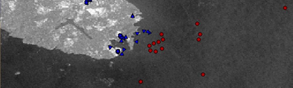
7 MARISS : ENVISAT ASAR 21:12:2010 Ship Detection Report LRIT Satellite AIS VMS AIS Correlated Ship 72 ships detected on SAR image have been identified using terrestrial AIS, Satellite AIS,VMS and LRIT


8 Ship Detection Report in AIS Format Ship detection products coming from the NRT processing chain make available non-correlated data. Custom applications collect information (position, speed, dimension) about suspected vessels and integrate them into an AIS platform NRT data coming from ship detection products processing
 who will be")

9 Ship Detection Report in AIS Format This provides added-value to the end-user (ITCG) who will be able to see, on the same monitoring platform both RT data, and NRT data coming from ship detection activity


10 16:40:00 16:45:00 16:50:00 16:55:00 17:00:00 17:05:00 17:29:00 24/12/ :21:00 17:11:00 AIS VDS COR DR VDS S2S


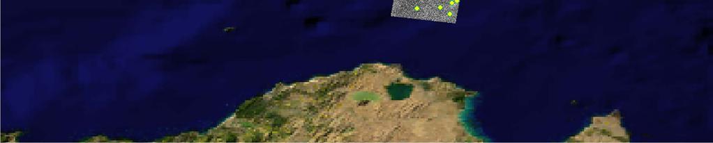
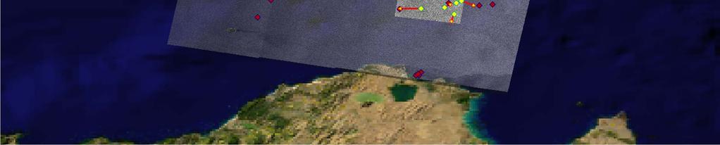
11 MARISS SCUP DURING LIBYAN CRISIS: SERVICE IN SUPPORT OF MONITORING OF THE MIGRATION FLOWS FROM TUNISIA AND LIBYA COASTS MALTA COSMO SkyMed 16/02/ :23 LAMPEDUSA LAMPEDUSA ZARZIS ZARZIS


 SAR")


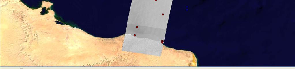
12 SAVINA TANKER MONITORED WITH COSMO SKYMED AND LRIT TECHNOLOGIES 1 StripMAP Mode (5 m res.) SAR acquisition and 1 Optical IKONOS image have been required over the probable landing place SAR TO SAR correlation: approximate ship position is extrapolated to the time of first available CSKMED acquisitions, then confirmed with LRIT tracks


 received")


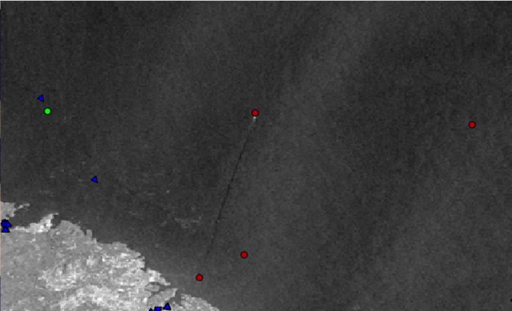
13 ITALIAN TANKER ENRICO IEVOLI: SAR image and LRIT tracks cross checking Enrico Ievoli hijacked on the 27/12/2011 SSAS ALERT received by ITCG O.C. I.M.R.C.C. Ship s route monitoring, using LRIT system Near Somali coasts, anymore ship reporting system positions (AIS, LRIT, SSAS messages) received by I.M.R.C.C. Collaboration with e-geos for satellite monitoring (SAR and optical) SPOT 5 mt)(1 optical image CSK (resolution High resolution mt) image 07/01/ /01/2012

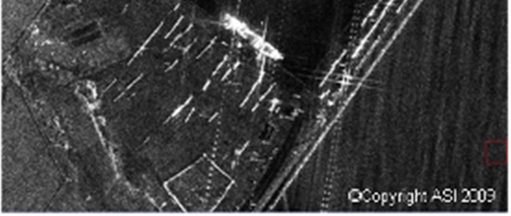
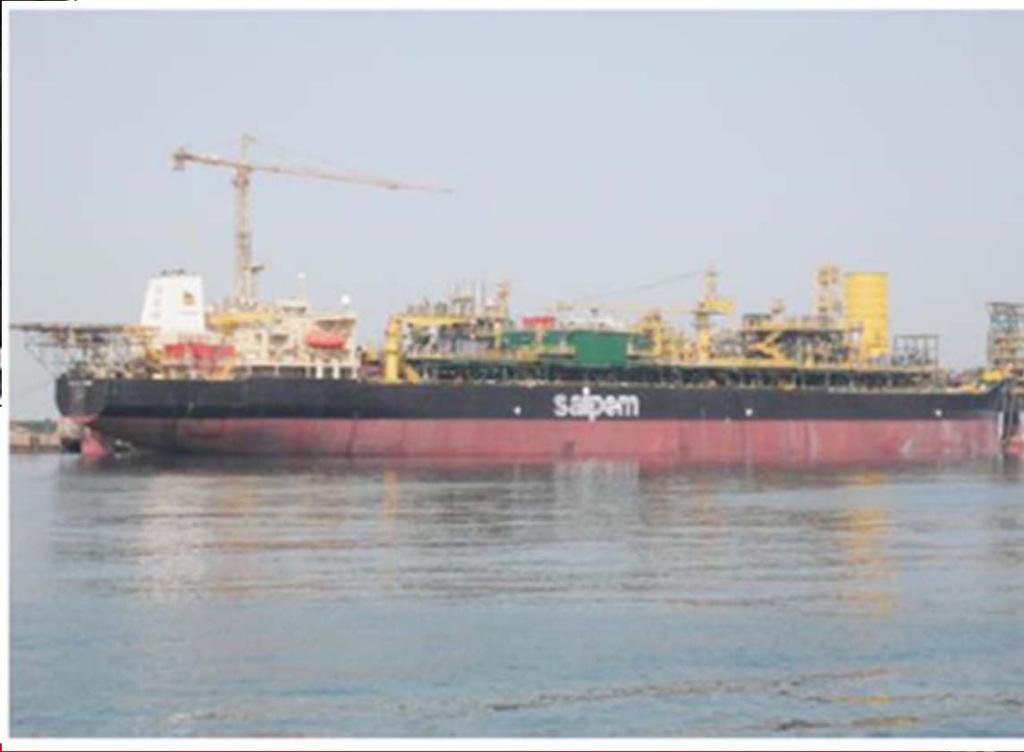

14 COSMO SkyMed for Maritime surveillance FPSO VESSEL FIRENZE monitoring from Dubai to Red Sea


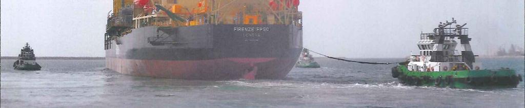
15 Ship and tug monitoring through CSK and LRIT from to


 PSC")
 on")

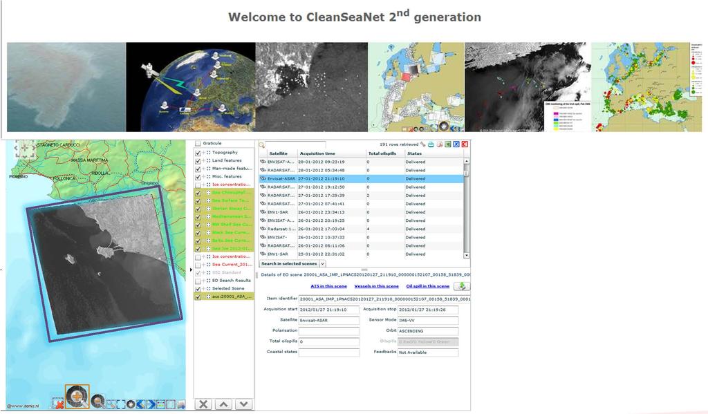
16 Case 1: M/N REINA 1 maltese flag OIL SPILL RESPONSE: CLEANSEANET System Satellite oil spill detection Satellite ship detection 18:36:00 GMT 19:42:00 GMT 21:36:00 GMT Investigation : to detect 6 possible oil spills polluter through detected AIS information through satellite in MARE image (SAR) PSC More detailed and MARPOL inspection carried out by Slovenian Authority (Ljubljana PSC Authority) on 11/05/2011: inoperative oil filtering equipment, an hold bilge pump/seawater line ball valve installed (used for possible illegal discharge), class investigation required.
 was berth in Porto")


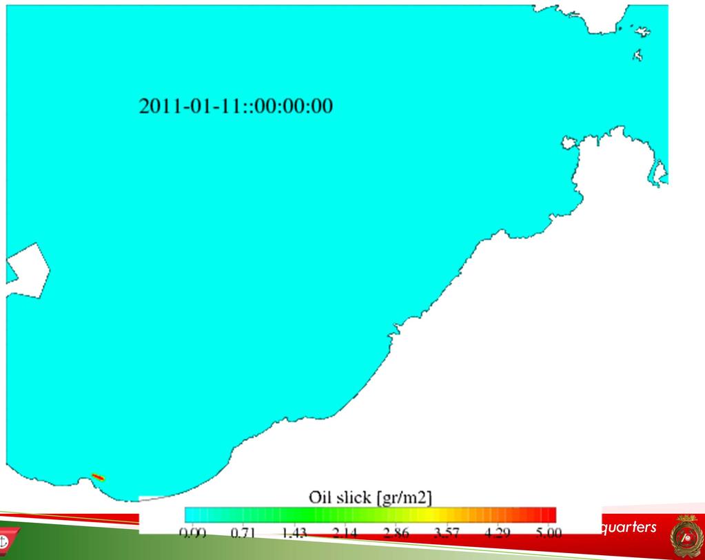
17 Porto Torres (Sardinia) oil spill On January 10 th 2011 M/T Emerald (maltese flag) was berth in Porto Torres Harbour, at the pier inside the Society E.On. oil terminal, performing discharge operations. On the 11 th, at oil terminal operator reported a fuel oil leak outside the berth of the E.ON Society oil Terminal.


18 Going on with the operations In the following days, from 12 to 16 of January, ITCG local offices performed all the oil response activities, patrolling the long shore area. OilwasfoundonlandintheareafromPorto Torres to Castelsardo. ATR 42 MANTA Unità Classe 300S Class 300S


19 On the 18 of January, iridescence was sighted off shore Santa Teresa di Gallura, northern of Porto Torres. ITCG Operational Centre decided to ask for cooperation, in a case study for the event.? starting a case study In order to correlate the two oil spills


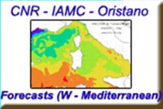
20 TRANSPORT SIMULATION: surface transportation of hydrocarbon particles and their relative beaching over the study period (11/01/ /01/2011). IAMC/CNR of Oristano ocean forecasting and Oil-Spill drifting high resolution models at sub-regional and coastal scale, in order to demonstrate the oil drifting from Porto Torres to Santa Teresa di Gallura


21 DENSITY SIMULATION: surface density of drifting oil spill over the study period (11/01/ /01/2011).
 and oil spill reached the beach from Capo Testa to Santa Teresa di Gallura (about 6 tons). The terminal operator estimated between 17 and 45 tons of product leaked into the sea.")
22 ITCG TECHNICAL GROUP FOR OPERATIONAL OCEANOGRAPHY CASE STUDY: to understand the correlation between Porto Torres oil spill (on the 11 on Jan.) and oil spill reached the beach from Capo Testa to Santa Teresa di Gallura (about 6 tons). The terminal operator estimated between 17 and 45 tons of product leaked into the sea. The results of the model developed by CNR showed that the oil spill position near Capo Testa was compatible with the paths followed by the oily particles leaked from P. Torres oil terminal. Even in the absence of chemical compatibility analysis of the samples, we could already assumed the correlation between the events.
")


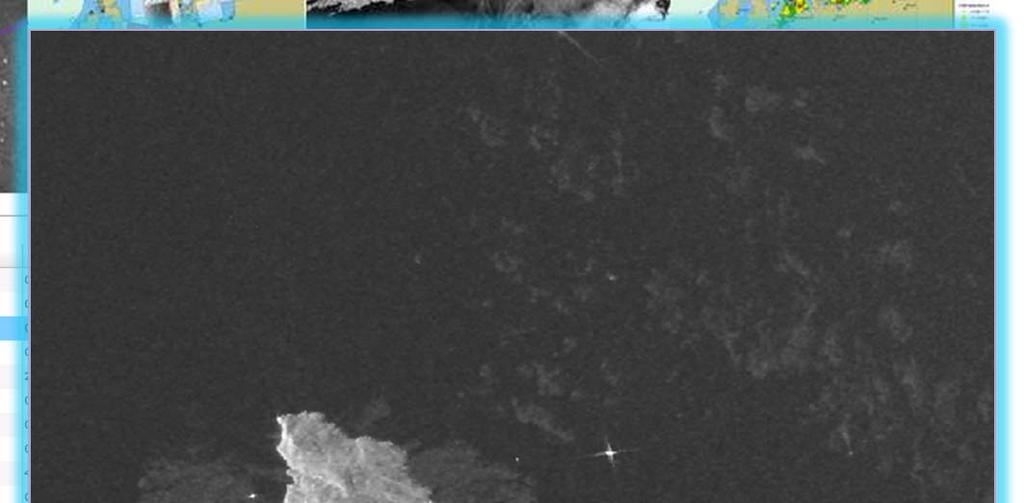
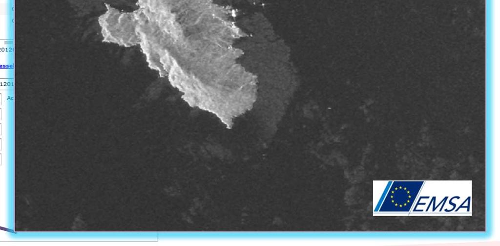
23 e-geos satellite service provider (COSMO-SkyMed, RADARSAT, ENVISAT ed ERS2) From a SAR image has been possible, through the elaboration of e-geos, estimate the volume of product present in the sea km² OIL SLICK Courtesy of MARISS PROJECT (ERS2 - ESA Archive)
24 e-geos satellite service provider (COSMO-SkyMed, RADARSAT, ENVISAT ed ERS2) Physical and chemical characteristics of the hydrocarbon, identified as HFO (Heavy Fuel Oil), based on the of classification reported in the literature; The area of the oil spill from the first data available on the area (ERS2) was A=0,97 - km 2 =9,7*10 5 m 2 ; Estimated volume: since the ERS2 data was acquired on the 11/01, that is the same day in which the spill occurred, as reported on BAOAC *, thickness of reference was considered to be S=0,05 mm=5*10-5 m. Estimated volume= 48,5 m 3 (compatible with the quantity of oil leaked declared by the oil terminal operator) (*) Bonn Agreement Oil Appearance Code (BAOAC)
25
 and uses three the15 satellites th of")


26 An An additional average of acquisition 1 image every request two has days been is made, acquired. The planning is focused over the first from the beginning of unloading operation until three weeks of February (until 17th) and uses three the15 satellites th of March 2012 to satisfy the monitoring needs Satellite CleanSeaNet additional planning Radarsat-2 Satellite for Costa 01/02/2012 Concordia 05:21 UTC Satellite Acquisition date and time Radarsat-1 02/02/ :00 at 05:25 UTC UTC Envisat Radarsat-2 Acquisition date and time Acquisition date and time 05/02/ :33 at 17:05 UTC UTC Radarsat-1 Radarsat-2 06/02/ :25 at at 05:25 17:09 UTC UTC Envisat 07/02/ :14 at at 09:37 09:24 UTC UTC UTC Radarsat-2 Envisat Radarsat-1 08/02/ :17 at at 17:05 21:05 UTC UTC UTC Envisat Radarsat-2 10/02/ :05 at at 21:19 05:25 UTC UTC Envisat 13/02/ :40 at 09:27 UTC UTC Radarsat-2 Envisat 14/02/ :00 at 21:08 UTC UTC Envisat Radarsat-2 Envisat Satellite Radarsat-1 16/02/ :31 UTC 17/02/ :13 UTC 21/02/ :02 UTC Acquisition date and time at 05:29 UTC Envisat 26/02/ :19 UTC As EMSA is concerned the only (and official) point of contact regarding Envisat oil spill emergencies 27/02/2012 in Italy 09:27 is the UTC Italian Coast Guard. From the CleanSeaNet perspective the Italian Coast Guard is the point of contact for all operational issues Radarsat at 05:33 UTC (emergencies and otherwise). Italian Coast 29/02/2012 Guard Headquarters 21:09 UTC Envisat
27
, REMPEC and other Authorities involved")
28 FORECAST OF THE POSSIBLE OIL POLLUTION SCENARIO IN CASE OF OIL SPILL FROM THE SHIP Situation at the beginning of the simulation 24 hours after the possible start of the oil spill Sended to: CPD Civil Protection Department Technical Committee, Peripheral Offices (ITCG Livorno, ITCG Porto S.Stefano, ITCG Giglio Island), REMPEC and other Authorities involved

 and wind forecasts (green arrow)")
29 48 and 72 hours after the possible start of the oil spill oil concentration on the coast is visualized with colours from blue to purple in Ton/km. Currents (black arrows) and wind forecasts (green arrow) are shown in the background


30 WP7 Satellite Data Access SeaU supported the Italian Coast Guard in the Giglio island oil pollution risk monitoring (Costa Concordia, January 2012): WorldView-2 19 th January 2012


31 WP7 Satellite Data Access COSMO-SkyMed ASI Processed by e-geos COSMO-SkyMed 4 Stripmap HIMAGE Acquisition Mode - 5m resol. 14th January 2012, h05:01 (UTC) Ascending Orbit, Right Looking HH Pol.


 Descending")
32 WP7 Satellite Data Access COSMO-SkyMed ASI Processed by e-geos COSMO-SkyMed 3 Stripmap HIMAGE Acquisition Mode - 5m resol. 18th January 2012, h17:18 (UTC) Descending Orbit, Right Looking VV Pol.


")

33 WP7 Satellite Data Access COSMO-SkyMed ASI Processed by e-geos COSMO-SkyMed 4 Spotlight Acquisition Mode - 1m resol. 19th January 2012, h18:18 (UTC) Descending Orbit, Left Looking HH Pol.


")

34 WP7 Satellite Data Access COSMO-SkyMed ASI Processed by e-geos COSMO-SkyMed 4 Spotlight Acquisition Mode - 1m resol. 20th January 2012, h05:13 (UTC) Ascending Orbit, Right Looking HH Pol.


35 Cooperation with European Fisheries Control Agency (EFCA) Blue Fin Tuna campaign 2012


36 Blue Fin Tuna campaign 2012 CSK2 StripMap :50 CSK4 StripMap :49 CSK2 StripMap :50 Cages Cages ASI

37 SAR used as standalone system
38 SAR used as standalone system


39 SAR used as standalone system


40 SAR used as standalone system ScanSAR Ship Signature Strip Map Ship Signature The two CSK images have been acquired in a timeframe of about 18 minutes. In this way it is possible to track no cooperative ships.
41 SAR used as standalone system SAR SENSORS, USED AS STAND-ALONE SYSTEMS, ALLOW TO Detect ships (cooperative or not) sailing the observed AOI (the probability to detect the ships depends on the ship s dimension with respect to the satellite data ground resolution). This probability is very high (>90%) if the ships dimension is about half the image ground resolution Localize detected ships (Geographical Coordinates) Classify detected ships (dimension classes) Determine ships velocity and course direction Track ships ( very useful for ships which are not transmitting their position) Detect and classify objects other than ships, such as fishing cages On the other hand, SAR sensors do not provide information on ship s identity (name, IMO number, etc )

42 Legacy Ship Reporting Systems


43 Legacy Ship Reporting Systems VMS Data 25/12/2010

44 Legacy Ship Reporting Systems VMS Data 25/12/2010 AIS Data 25/12/2010


45 Legacy Ship Reporting Systems VMS Data 25/12/2010 AIS Data 25/12/2010 LRIT Data 25/12/2010 SAT-AIS Data 25/12/2010


46 Legacy Ship Reporting Systems VMS Data 25/12/2010 AIS Data 25/12/2010 LRIT Data 25/12/2010 SAT-AIS Data 25/12/2010 Fusion Processing Are the ships indicated in the map all the ships which were present at sea???
47 Legacy Systems LEGACY SYSTEMS (AIS,LRIT,VMS, ) ALLOW TO Localize cooperative ships Identify cooperative ships Give access to information relevant to the ship voyage An integrated approach is the key point for success. In particular, the integration of satellite sensors with existing surveillance systems will improve monitoring capability and efficiency, while reducing overall costs.


48 Conventional Ship Reporting Systems VMS Data 25/12/2010 AIS Data 25/12/2010 LRIT Data 25/12/2010 SAT-AIS Data 25/12/2010 Fusion Processing EO Data 25/12/2012
49 Example of Integrated Product CSK1 HI Data 30/12/ :04:00

50 Example of Integrated Product CSK1 HI Data 30/12/ :04:00 CSK1 HI Ship Detection Report (20)
51 Example of Integrated Product CSK1 HI Data 30/12/ :04:00 CSK1 HI Ship Detection Report (20) AIS Data 30/12/ :00-06:00
52 Example of Integrated Product CSK1 HI Data 30/12/ :04:00 CSK1 HI Ship Detection Report (20) AIS Data 30/12/ :00-06:00 VMS Data 30/12/ :00-06:00 VMS extrapolated at CSK1 Time

53 Example of Integrated Product CSK1 HI Data 30/12/ :04:00 CSK1 HI Ship Detection Report (20) AIS Data 30/12/ :00-06:00 VMS Data 30/12/ :00-06:00 VMS extrapolated at CSK1 Time Not Correlated Ships

54 Example of SAR and VMS Correlation VMS Possible Oil Spill Ship not correlated Correlated ship

55 Thank you for your kind attention!


56 ANY QUESTION? contacts:
Space Based Vessel Detection - Combining Earth Observation and AIS for Maritime surveillance TEXAS V and C-Σ III
 Space Based Vessel Detection - Combining Earth Observation and AIS for Maritime surveillance TEXAS V and C-Σ III Tony Bauna Director, Product and Service Development, Kongsberg Satellite Services, Tromsø,
PMAR Piracy, Maritime Awareness & Risks
 PMAR Piracy, Maritime Awareness & Risks Maritime Situational Awareness for Counter-Piracy European Commission Joint Research Centre 13 June 2012 GeoMaritime, London 1 MSA for counter-piracy study Key elements
*For International Stewardship of the Maritime Environment and its Resources. Photo
 *For International Stewardship of the Maritime Environment and its Resources *For Maritime Safety *For Security Photo # Providing Environmental Monitoring* # Increasing Security* # Enabling Safety Efforts*
*For International Stewardship of the Maritime Environment and its Resources. Photo
 *For International Stewardship of the Maritime Environment and its Resources *For Maritime Safety *For Security Photo # Providing Environmental Monitoring* # Increasing Security* # Enabling Safety Efforts*
Satellite Technologies for Fisheries Monitoring, Control and Surveillance (MCS)
") JRC IPSC Maritime Affairs 1 Satellite Technologies for Fisheries Monitoring, Control and Surveillance (MCS) Juan Cicuendez, Marlene Alvarez JRC Info Day Madrid, 2 June 2010 IPSC - Institute for the Protection
JRC IPSC Maritime Affairs 1 Satellite Technologies for Fisheries Monitoring, Control and Surveillance (MCS) Juan Cicuendez, Marlene Alvarez JRC Info Day Madrid, 2 June 2010 IPSC - Institute for the Protection
Satellite services for maritime security
 Satellite services for ITS-T Sophia Antipolis 6 June 2007 Jean-Pierre Cauzac, CLS - Collecte Localisation Satellites 35 Are the seas becoming more dangerous? IMB report 2006 shows improvement: 239 piracy
SAR missions for oceanography at the European Space Agency
 SAR missions for oceanography at the European Space Agency ERS-1, ERS-2, Envisat, Sentinel-1A, Sentinel-1B, ESA 3 rd Party Missions (ALOS) Prepared by ESA teams and ESA supporting companies ESA and SAR
KONGSBERG. WORLD CLASS through people, technology and dedication WORLD CLASS through people, technology and dedication
 WORLD CLASS through people, technology and dedication WORLD CLASS through people, technology and dedication Skipsdeteksjon fra radarsatellitter SkipSat Richard Hallr Kongsberg Satellite Services AS (KSAT)
Demonstrator of a Data Processing Centre (DPC) for satellite-based AIS services
 for satellite-based AIS services") Page 1 Demonstrator of a Data Processing Centre (DPC) for satellite-based AIS services 19/20 April 2012 gfabritius@cls.fr Overview of the presentation Page 2 Introducing CLS Introducing AIS / SAT-AIS Scope
Page 1 Demonstrator of a Data Processing Centre (DPC) for satellite-based AIS services 19/20 April 2012 gfabritius@cls.fr Overview of the presentation Page 2 Introducing CLS Introducing AIS / SAT-AIS Scope
Satellite data for Maritime Operations. Andreas Hay Kaljord Project Manager Energy, Environment & Security
 Satellite data for Maritime Operations Andreas Hay Kaljord Project Manager Energy, Environment & Security Kongsberg Satellite Services (KSAT) World leading provider within our business area Supports 85
the use of satellite radar to improve surveillance of oil pollution over large areas
 Groupe de travail ORFEO - Mer et Littoral Réunion du 14 octobre 2004 the use of satellite radar to improve surveillance of oil pollution over large areas François Parthiot Cedre - Delegate for the Mediterranean
Innovative Maritime Surveillance Capabilities. Pre-operational Services for Highly. Development of. Maria Angelucci, e-geos
 Development of Pre-operational Services for Highly Innovative Maritime Surveillance Capabilities ASI Workshop - 7 th Framework Program Rome, June 27 th, 2012 Maria Angelucci, e-geos 1 Figures Start date:
WHAT IS NEXT IN EARTH OBSERVATION. SkyMed Mission
 WHAT IS NEXT IN EARTH OBSERVATION COSMO-SkyMed SkyMed Mission Paolo Ammendola Italian Space Agency Florence, Sept. 19, 2001 ammendola@asi asi.it THE NEEDS Market studies indicate that the value of the
Operational use of satellite SAR at EMSA
 Operational use of satellite SAR at EMSA 25 January 2010 SEASAR Workshop ESRIN, Frascati 1 Marin Chintoan-Uta Head of Unit Satellite Based Monitoring Services The structure of the presentation Introduction
COSMO-SkyMed Mission Status Presented by Giovanni VALENTINI (ASI)
") COSMO-SkyMed Mission Status Presented by Giovanni VALENTINI (ASI) FIRST SATELLITE FIRST SATELLITE OF THE CONSTELLATION SUCCESSFULLY LAUNCHED 08 June 2007 03:35 (GMT) Vandenberg U.S.A. Air Force Base SECOND
COSMO-SkyMed Mission Status Presented by Giovanni VALENTINI (ASI) FIRST SATELLITE FIRST SATELLITE OF THE CONSTELLATION SUCCESSFULLY LAUNCHED 08 June 2007 03:35 (GMT) Vandenberg U.S.A. Air Force Base SECOND
SHIP MONITORING SERVICE SIMONS GMV, 2015 Property of GMV All rights reserved
 SHIP MONITORING SERVICE 01-12-2015 Property of GMV All rights reserved Ship Monitoring Service GMV SECURITY EXPERIENCE Property of GMV All rights reserved GMV: SECURITY BACKGROUND GMV experience in the
KONGSBERG SATELLITE SERVICES Earth Observation for Maritime Operations Current Capabilities and Future Potential
 KONGSBERG SATELLITE SERVICES 2017 Earth Observation for Maritime Operations Current Capabilities and Future Potential Andreas Hay Kaljord Project Manager KSAT HQ IN TROMSØ - 69N WELCOME TO TROMSØ Established
NEREIDS: New concepts in maritime surveillance for consolidating operational developments
 SEASAR12 WORKSHOP, TROMSO, 06-12 NEREIDS: New concepts in maritime surveillance for consolidating operational developments Property of GMV All rights reserved SUMMARY NEREIDS PROJECT NEREIDS CHALLENGES
KONGSBERG SATELLITE SERVICES 2017 Line Steinbakk, Director Programs. Himmel og hav - Ålesund 3. Oktober 2017
 KONGSBERG SATELLITE SERVICES 2017 Line Steinbakk, Director Programs Himmel og hav - Ålesund 3. Oktober 2017 KSAT HQ IN TROMSØ 69N Established in 1967 Kongsberg Satellite Services since 2002 World leading
Utilization of Radar data for Maritime Surveillance
 INDESO Project Utilization of Radar data for Maritime Surveillance DENDY MAHABROR MARINE RESEARCH CENTER INDESO RADAR GROUND STATION RADARSAT-2 AND COSMO-SKYMED BALI INDESO satelit VMS satelite radar vessel
ESA IAP Blue Belt demonstration project:
 Page 1 ESA IAP Blue Belt demonstration project: supporting the European Maritime Safety Agency (EMSA) Blue Belt Project, by providing a service based on satellite based AIS data complementing the terrestrial
RESOLUTION MSC.229(82) (adopted on 5 December 2006) ADOPTION OF A NEW MANDATORY SHIP REPORTING SYSTEM "IN THE GALAPAGOS PARTICULARLY SENSITIVE SEA
 (adopted on 5 December 2006) ADOPTION OF A NEW MANDATORY SHIP REPORTING SYSTEM IN THE GALAPAGOS PARTICULARLY SENSITIVE SEA") MSC 82/24/Add.2 RESOLUTION MSC.229(82) IN THE GALAPAGOS PARTICULARLY SENSITIVE SEA AREA (PSSA) (GALREP) THE MARITIME SAFETY COMMITTEE, RECALLING Article 28(b) of the Convention on the International Maritime
MSC 82/24/Add.2 RESOLUTION MSC.229(82) IN THE GALAPAGOS PARTICULARLY SENSITIVE SEA AREA (PSSA) (GALREP) THE MARITIME SAFETY COMMITTEE, RECALLING Article 28(b) of the Convention on the International Maritime
Co-ReSyF RA lecture: Vessel detection and oil spill detection
 This project has received funding from the European Union s Horizon 2020 Research and Innovation Programme under grant agreement no 687289 Co-ReSyF RA lecture: Vessel detection and oil spill detection
Juan GAVIRIA, Sector Leader AFTTR
 Earth Observation in support of the Western Indian Ocean Marine Highway Development and Coastal and Marine Contamination Prevention Project - Oil spill detection & Coral reef monitoring Juan GAVIRIA, Sector
Western Indian Ocean Marine Highway Development and Coastal and Marine Contamination Prevention Project - Oil spill detection & Coral reef monitoring
 Earth Observation in support of the Western Indian Ocean Marine Highway Development and Coastal and Marine Contamination Prevention Project - Oil spill detection & Coral reef monitoring Juan GAVIRIA, Sector
COSMO-SkyMed Mission Status Presented by Fabrizio BATTAZZA (ASI)
") COSMO-SkyMed Mission Status Presented by Fabrizio BATTAZZA (ASI) COSMO-1 & COSMO-2 LAUNCHES FIRST SATELLITE OF THE CONSTELLATION SUCCESSFULLY LAUNCHED 08 June 2007 03:35 (GMT) Vandenberg U.S.A. Air Force
COSMO-SkyMed Mission Status Presented by Fabrizio BATTAZZA (ASI) COSMO-1 & COSMO-2 LAUNCHES FIRST SATELLITE OF THE CONSTELLATION SUCCESSFULLY LAUNCHED 08 June 2007 03:35 (GMT) Vandenberg U.S.A. Air Force
SAR Interferometry Capabilities of Canada's planned SAR Satellite Constellation
 SAR Interferometry Capabilities of Canada's planned SAR Satellite Constellation Dirk Geudtner, Guy Séguin,, Ralph Girard Canadian Space Agency RADARSAT Follow-on Program CSA is in the middle of a Phase
RADARSAT-2 Modes and Applications
 RADARSAT-2 Modes and Applications Gordon Staples MDA Geospatial Services February 6, 2017 1 Introduction RADARSAT-2 was developed to meet operational needs via a versatile space segment and a responsive
Abstract. 1. Introduction
 Title: Satellite surveillance for maritime border monitoring Author: H. Greidanus Number: File: GMOSSBordMon1-2.doc Version: 1-2 Project: GMOSS Date: 25 Aug 2004 Distribution: Abstract Present day remote
Integration of AIS functionalities
 Integration of AIS functionalities by John O. Klepsvik FARGIS 05 March 01, 2005 WORLD CLASS through people, technology and dedication WORLD CLASS through people, technology and dedication KONGSBERG March
Sensors, Tools and the Common Operating Picture. Sensors, Tools and the Common Operating Picture 14 th April Middleburg
 Sensors, Tools and the Common Operating Picture 14 th April 2015 - Middleburg Aptomar Established in 2005 Owned by Statoil, Investinor, Proventure Seed, Verdane Capitol Have developed and control all IPR
Earth Observation and Sensing Technologies: a focus on Radar Imaging Developments. Riccardo Lanari
 Earth Observation and Sensing Technologies: a focus on Radar Imaging Developments Riccardo Lanari Institute for Electromagnetic Sensing of the Environment (IREA) National Research Council of Italy (CNR)
MEDITERRANEAN AND BLACK SEAS HYDROGRAPHIC COMMISSION
 MEDITERRANEAN AND BLACK SEAS HYDROGRAPHIC COMMISSION XVIII CONFERENCE CONTRIBITION BY MALTA Istanbul, Turkey 25-27 September 2013 1 Item 1 Hydrographic Office Transport Malta is responsible for all transport
A Space-Based Solution for Illegal, Unregulated & Unreported Fishing. Emmanouil Detsis, International Space University
 Project Catch A Space-Based Solution for Illegal, Unregulated & Unreported Fishing Emmanouil Detsis, International Space University Project Catch COPUOS Presentation Team Project Oceans International Intercultural
The ERS contribution to Oil Spill Monitoring - From R&D towards an operational service -
 The ERS contribution to Oil Spill Monitoring - From R&D towards an operational service - J.P. Pedersen, T.Bauna, L.G. Seljelv, L. Steinbakk, R.T.Enoksen Tromsø Satellite Station, N-9291 Tromsø, Norway
ROUTEING OF SHIPS, SHIP REPORTING AND RELATED MATTERS. Establishment of a Mandatory Ship Reporting System in the
 INTERNATIONAL MARITIME ORGANIZATION E SUB-COMMITTEE ON SAFETY OF NAVIGATION 48th session Agenda item 3 IMO NAV 48/3/2 11 April 2002 Original: ENGLISH ROUTEING OF SHIPS, SHIP REPORTING AND RELATED MATTERS
S. Africa Cape Town. S. Africa Australia miles. Maritime Interest 31/07/2013. NAV 2013 Navigation Symposium
 NAV 2013 Navigation Symposium S. Africa Cape Town SESSION 10: Expanding role of Vessel Traffic Services (VTS) Vessel Monitoring in South Africa and Beyond - Why Safety of Navigation? Centre for Sea Watch
ERS/ENVISAT ASAR Data Products and Services
 ERS/ENVISAT ASAR Data Products and Services Andrea Celentano Business Manager celentan@eurimage.com What is Eurimage? Founded in 1989 Current shareholders: Since 1989 Commercial Partner of the European
Satellite SAR ship detections from PMAR in support of Cutlass Express
 Satellite SAR ship detections from PMAR in support of Cutlass Express Harm Greidanus, Marlene Alvarez, Tulay Cokacar, Andrea Pesaresi, Carlos Santamaria, Vladimir Kyovtorov EUR 25140 EN - 2011 The mission
Port Security and Technology - the U.S. Perspective. Michael S. Bruno Stevens Institute of Technology March 14, 2012
 Port Security and Technology - the U.S. Perspective Michael S. Bruno Stevens Institute of Technology March 14, 2012 CSR A Department of Homeland Security National Center of Excellence for Port Security
Kongsberg Satellite Services, KSAT
 SvalSat, Earth Station at 78 North Kongsberg Satellite Services, KSAT Making Sense of Space Sigmund Dehli International Sales Manager WORLD CLASS through people, technology and dedication My plan KSAT
Remote Sensing Analysis Framework for Maritime Surveillance Application
 Remote Sensing Analysis Framework for Maritime Surveillance Application Olaf Frauenberger, Egbert Schwarz, Sergey Voinov Maritime Security Lab Neustrelitz (DFD) Maritime Big Data Workshop, 9-11 May, La
Security Systems Division
 Security Systems Division SIVE A PIONEER MARITIME BORDER SURVEILLANCE SYSTEM. WHAT IS BEYOND? Pros and cons of the SIVE system today in the new coastal and deepwater border scenario and our vision of a
AIS and SATAIS. AIS is a globally available, mandatory and thus unique information source of each sea going
 AIS and SATAIS AIS is a globally available, mandatory and thus unique information source of each sea going vessel above 299 GRT including MMSI, name, position, speed, direction, cargo type, port of destination
L AGENCE NATIONALE DES FREQUENCES (ANFR) From Titanic to satellite from Morse to digital Entry in a new era for the maritime community
 From Titanic to satellite from Morse to digital Entry in a new era for the maritime community") L AGENCE NATIONALE DES FREQUENCES (ANFR) From Titanic to satellite from Morse to digital Entry in a new era for the maritime community ITU regional seminar 6-8 June 2018 St-Petersburg, Russian Federation
L AGENCE NATIONALE DES FREQUENCES (ANFR) From Titanic to satellite from Morse to digital Entry in a new era for the maritime community ITU regional seminar 6-8 June 2018 St-Petersburg, Russian Federation
European Commission Workshop «SATELLITE IMAGERY AND ILLEGAL OIL SPILLS IN EUROPE AND IN THE MEDITERRANEAN» Round table 1 : «DETECTION TECHNIQUES»
 European Commission Workshop «SATELLITE IMAGERY AND ILLEGAL OIL SPILLS IN EUROPE AND IN THE MEDITERRANEAN» Round table 1 : «DETECTION TECHNIQUES» Round table 2 : «MUTUAL INFORMATION AND PROSECUTION PROCEDURES»
EMSA Additional Dataset Status 31 st March 2015
 EMSA Additional Dataset Status 31 st March 2015 DWH_MG2_EMSA_ADD_001a: _rush_optical_hr1... 2 DWH_MG2_EMSA_ADD_001b: _rush_optical_hr2... 3 DWH_MG2_EMSA_ADD_002a: ew acquisition_rush_optical_hr1... 4 DWH_MG2_EMSA_ADD_002b:
Cost Effective Control of your Coastal Waters
 Cost Effective Control of your Coastal Waters Olov Fäst SSC Airborne Systems 2013-07-03 SSC: A comprehensive space industry Founded in 1972 ~650 employees (2012) ~100 M turnover (2012) Since the start
Earth Observation Opportunities to Enhance Maritime Safety
 http://www.transnav.eu the International Journal on Marine Navigation and Safety of Sea Transportation Volume 11 Number 4 December 2017 DOI: 10.12716/1001.11.04.17 Earth Observation Opportunities to Enhance
High resolution ground deformations monitoring by COSMO-SkyMed PSP SAR interferometry
 High resolution ground deformations monitoring by COSMO-SkyMed PSP SAR interferometry Mario Costantini e-geos - an ASI/Telespazio Company, Rome, Italy mario.costantini@e-geos.it Summary COSMO-SkyMed satellite
Copyright 2016 Raytheon Company. All rights reserved. Customer Success Is Our Mission is a registered trademark of Raytheon Company.
 Make in India Paradigm : Roadmap for a Future Ready Naval Force Session 9: Coastal Surveillance, Response Systems and Platforms Nik Khanna, President, India April 19, 2016 "RAYTHEON PROPRIETARY DATA THIS
SAR Multi-Temporal Applications
 SAR Multi-Temporal Applications 83230359-DOC-TAS-EN-001 Contents 2 Advantages of SAR Remote Sensing Technology All weather any time Frequencies and polarisations Interferometry and 3D mapping Change Detection
Observing Dry-Fallen Intertidal Flats in the German Bight Using ALOS PALSAR Together With Other Remote Sensing Sensors
 Observing Dry-Fallen Intertidal Flats in the German Bight Using ALOS PALSAR Together With Other Remote Sensing Sensors Martin Gade, Institut für Meereskunde & Kerstin Stelzer Brockmann Consult Outline
Downloaded by on April 16, DOI: /
 Polar Epsilon: Joint Space-Based Wide Area Surveillance and Support Project LCdr Robert Quinn Project Director Polar Epsilon Directorate of Space Development Phone: +1(613)945-5212 Quinn.rj2@forces.gc.ca
COMMUNICATIONS FOR MARITIME SAFETY AND EFFICIENCY. Francis Zachariae, Secretary-General, IALA
 COMMUNICATIONS FOR MARITIME SAFETY AND EFFICIENCY Francis Zachariae, Secretary-General, IALA IALA and its Purpose Non profit, international technical association established in 1957 Two Goals aimed at
Integrating Spaceborne Sensing with Airborne Maritime Surveillance Patrols
 22nd International Congress on Modelling and Simulation, Hobart, Tasmania, Australia, 3 to 8 December 2017 mssanz.org.au/modsim2017 Integrating Spaceborne Sensing with Airborne Maritime Surveillance Patrols
Oil spill detection in the Chinese Seas by spaceborne synthetic aperture radars: challenges and pitfalls (Project: OPAC )
") Oil spill detection in the Chinese Seas by spaceborne synthetic aperture radars: challenges and pitfalls (Project: 10705 OPAC ) Werner Alpers Institute of Oceanography, University of Hamburg, Hamburg,
Oil spill detection in the Chinese Seas by spaceborne synthetic aperture radars: challenges and pitfalls (Project: 10705 OPAC ) Werner Alpers Institute of Oceanography, University of Hamburg, Hamburg,
RESOLUTION MSC.278(85) (adopted on 1 December 2008) ADOPTION OF THE NEW MANDATORY SHIP REPORTING SYSTEM "OFF THE COAST OF PORTUGAL - COPREP"
 (adopted on 1 December 2008) ADOPTION OF THE NEW MANDATORY SHIP REPORTING SYSTEM OFF THE COAST OF PORTUGAL - COPREP") MSC 85/26/Add.1 RESOLUTION MSC.278(85) SYSTEM OFF THE COAST OF PORTUGAL COPREP THE MARITIME SAFETY COMMITTEE, RECALLING Article 28 of the Convention on the International Maritime Organization concerning
MSC 85/26/Add.1 RESOLUTION MSC.278(85) SYSTEM OFF THE COAST OF PORTUGAL COPREP THE MARITIME SAFETY COMMITTEE, RECALLING Article 28 of the Convention on the International Maritime Organization concerning
New Funding Opportunities to Support Safety of Navigation: EGNOS and Galileo
 New Funding Opportunities to Support Safety of Navigation: EGNOS and Galileo e-navigation Underway 31 January-2 February 2017 GSA 2016 The European GNSS Agency (GSA) today: Staff: about 145 Nationalities:
Class Update on Latest Ship to Ship Transfer Plan
 Class Update on Latest Ship to Ship Transfer Plan Binbin Li 17 May 2017 7th Forum on STS Best Practices - SNI, Singapore 2017 American Bureau of Shipping. All rights reserved Outline This presentation
Multi Sensor Data Fusion
 Multi Sensor Data Fusion for improved maritime traffic monitoring in the Canadian Arctic Giulia Battistello*, Martin Ulmke*, Javier Gonzalez*, Camilla Mohrdieck** (*) Fraunhofer FKIE Sensor Data and Information
The Ability of a Small Satellite Constellation to Tip and Cue Other Commercial Assets
 Changing the economics of space The Ability of a Small Satellite Constellation to Tip and Cue Other Commercial Assets Becky Cudzilo - Surrey Satellite US, LLC K.C. Foley - GeoEye, Inc. Chandler Smith -
CSA Report on Earth Observation
 CSA Report on Earth Observation Presented at Shanghai, China May 13 17, 2013 Dr. Satish K. Srivastava WGCV Chair & CSA Member of WGCV Page 1 RADARSAT-1 Program Status Since 22:30 UTC March 29, 2013, it
Sea objects detection with COSMO/SkyMed
 Sea objects detection with COSMO/SkyMed Università di Firenze, CNR-IREA, Università di Napoli Federico II, Politecnico di Bari, Università del Piemonte Orientale FINAL WORKSHOP ACHIEVED RESULTS IN RESPONSE
Introduction to KOMPSAT
 Introduction to KOMPSAT September, 2016 1 CONTENTS 01 Introduction of SIIS 02 KOMPSAT Constellation 03 New : KOMPSAT-3 50 cm 04 New : KOMPSAT-3A 2 KOMPSAT Constellation KOMPSAT series National space program
ESA GOVSATCOM Precursor Outline Proposals
 ESA GOVSATCOM Precursor Outline Proposals Summary Reporting to ESA/EDA Bilateral 23 May 2016 23/05/2016 Slide 1 ESA UNCLASSIFIED - For Internal Use ESA GOVSATCOM Precursor Outline Proposals Summary Reporting
European Space Agency and IPY
 European Space Agency and IPY ESA supports IPY 2007-2008 activities: First ESA step was a dedicated Announcement Opportunity (AO) for EO data provision in support IPY, released in 2006, with data provision
ESSnet pilot AIS data. Anke Consten, Eleni Bisioti and Olav Grøndal (23 February 2017, Sofia)
") ESSnet pilot AIS data Anke Consten, Eleni Bisioti and Olav Grøndal (23 February 2017, Sofia) Overview 1. Introduction 2. Deliverables ESSnet pilot AIS data 3. Data access and handling 4. Quality of AIS
ESSnet pilot AIS data Anke Consten, Eleni Bisioti and Olav Grøndal (23 February 2017, Sofia) Overview 1. Introduction 2. Deliverables ESSnet pilot AIS data 3. Data access and handling 4. Quality of AIS
e-navigation Underway International February 2016 Kilyong Kim(GMT Co., Ltd.) Co-author : Seojeong Lee(Korea Maritime and Ocean University)
 Co-author : Seojeong Lee(Korea Maritime and Ocean University)") e-navigation Underway International 2016 2-4 February 2016 Kilyong Kim(GMT Co., Ltd.) Co-author : Seojeong Lee(Korea Maritime and Ocean University) Eureka R&D project From Jan 2015 to Dec 2017 15 partners
e-navigation Underway International 2016 2-4 February 2016 Kilyong Kim(GMT Co., Ltd.) Co-author : Seojeong Lee(Korea Maritime and Ocean University) Eureka R&D project From Jan 2015 to Dec 2017 15 partners
IMO WORLD-WIDE RADIONAVIGATION SYSTEM (WWRNS) GALILEO receiver performance standards. Submitted by the European Commission
 GALILEO receiver performance standards. Submitted by the European Commission") INTERNATIONAL MARITIME ORGANIZATION E IMO SUB-COMMITTEE ON SAFETY OF NAVIGATION 50th session Agenda item 13 2 April 2004 Original: ENGLISH WORLD-WIDE RADIONAVIGATION SYSTEM (WWRNS) GALILEO receiver performance
INTERNATIONAL MARITIME ORGANIZATION E IMO SUB-COMMITTEE ON SAFETY OF NAVIGATION 50th session Agenda item 13 2 April 2004 Original: ENGLISH WORLD-WIDE RADIONAVIGATION SYSTEM (WWRNS) GALILEO receiver performance
RESOLUTION MSC.233(82) (adopted on 5 December 2006) ADOPTION OF THE PERFORMANCE STANDARDS FOR SHIPBORNE GALILEO RECEIVER EQUIPMENT
 (adopted on 5 December 2006) ADOPTION OF THE PERFORMANCE STANDARDS FOR SHIPBORNE GALILEO RECEIVER EQUIPMENT") MSC 82/24/Add.2 RESOLUTION MSC.233(82) THE MARITIME SAFETY COMMITTEE, RECALLING Article 28(b) of the Convention on the International Maritime Organization concerning the functions of the Committee, RECALLING
MSC 82/24/Add.2 RESOLUTION MSC.233(82) THE MARITIME SAFETY COMMITTEE, RECALLING Article 28(b) of the Convention on the International Maritime Organization concerning the functions of the Committee, RECALLING
Outline. From AGEA-JRC I (2007) to AGEA-JRC II ( ) COSMO-SkyMed constellation for Earth observation and applications
 to AGEA-JRC II ( ) COSMO-SkyMed constellation for Earth observation and applications") Outline From AGEA-JRC I (2007) to AGEA-JRC II (2008-09) COSMO-SkyMed constellation for Earth observation and applications COSMO-SkyMed GeoAccuracy assessment o Geometric o Parcels measurements performances
Outline From AGEA-JRC I (2007) to AGEA-JRC II (2008-09) COSMO-SkyMed constellation for Earth observation and applications COSMO-SkyMed GeoAccuracy assessment o Geometric o Parcels measurements performances
SUMMARY REPORT AND RECOMMENDATIONS ON THE PREVENTION OF MARINE OIL POLLUTION IN THE ARCTIC.
 Arctic Council Open Access Repository Arctic Council http://www.arctic-council.org/ 1.8 Sweden Chairmanship I (May 2011 - May 2013) 4. SAO Meeting, March 2013, Stockholm, Sweden SUMMARY REPORT AND RECOMMENDATIONS
THE USE OF SATELLITE IMAGERY TO MONITOR OIL POLLUTION IN LEBANON
 THE USE OF SATELLITE IMAGERY TO MONITOR OIL POLLUTION IN LEBANON Muellenhoff, Oliver 1 ; Topouzelis, Kostas 2 ; Tarchi, Dario 2 ; Bulgarelli, Barbara 2 ; Ferraro, Guido 2 ; Fortuny, Joaquim 2 1 EC JRC
Vessel Traffic Generator. Agent based maritime traffic generator
 Vessel Traffic Generator Agent based maritime traffic generator Motivation Why (I) Need for data sets to develop and validate Maritime Situational Awareness algorithms Problem Real-world data (e.g. AIS
CASE STUDY OF THE ICELANDIC INTEGRATED SYSTEM FOR MONITORING, CONTROL AND SURVEILLANCE
 FAO Fisheries and Aquaculture Circular No. 1053 FIRO/C1053 (En) ISSN 2070-6065 CASE STUDY OF THE ICELANDIC INTEGRATED SYSTEM FOR MONITORING, CONTROL AND SURVEILLANCE Copies of FAO publications can be requested
Market strategy update in Maritime segment. This presentation can be interpreted only together with the oral comments accompanying it
 Market strategy update in Maritime segment This presentation can be interpreted only together with the oral comments accompanying it 2 Market sub-segments and applications Recreational navigation: GNSS
GMDSS modernisation and e-navigation: spectrum needs
 ETSI Workshop "Future Evolution of Marine Communication", 7-8 November 2017, Sophia Antipolis, France GMDSS modernisation and e-navigation: spectrum needs Karlis Bogens BR Terrestrial Services Department
Prague - 29 June 2009 A. COLETTA COLETTA. COSMO-SkyMed Mission: COSMO-SkyMed Mission. Application and Data Access
 A. A. COLETTA COLETTA COSMO-SkyMed COSMO-SkyMed Mission Mission Manager Manager ITALIAN ITALIAN SPACE SPACE AGENCY AGENCY COSMO-SkyMed Mission: Application and Data Access The COSMO-SkyMed PROGRAMME The
09 Apr 2013 Commodore Mark Mellett DSM; PhD; FNI
 Cooperation in the Atlantic Basin Realities and Possibilities - Atlantic 5 09 Apr 2013 Commodore Mark Mellett DSM; PhD; FNI mark.mellett@defenceforces.ie AGENDA Context Governance Challenges Atlantic Realities
Radio Frequency Sensing from Space
 Radio Frequency Sensing from Space Edoardo Marelli ITU-R WP 7C Chairman ITU-R Seminar Manta (Ecuador) 20 September 2012 Why observing the Earth from space? Satellites orbiting around the Earth offer an
Marine Earth Observation & Applications at University College Cork
 Marine Earth Observation & Applications at University College Cork Rory Scarrott, with input from Eimear Tuohy & Chiara Pratola 2 nd Irish Industry Space Day, Hibernian Club, Dublin, September 2 nd 2015
Enhanced Maritime Traffic Picture for the Canadian Arctic
 Enhanced Maritime Traffic Picture for the Canadian Arctic Giulia Battistello*, Martin Ulmke*, Camilla Mohrdieck** (*) Fraunhofer FKIE - Sensor Data and Information Fusion Department - Wachtberg, Germany
This circular summarizes the various important aspects of the LRIT system with a view to enabling companies to ensure compliance in a timely manner.
 Luxembourg, 29/10/2008 CIRCULAR CAM 02/2008 N/Réf. : AH/63353 Subject : Long-Range Identification and Tracking of Ships (LRIT) To : All ship owners, ship operators and designated persons of Luxembourg
Status of Sentinel-1 and acquisition plans for GFOI
 Status of Sentinel-1 and acquisition plans for GFOI Frank Martin Seifert, Pierre Potin, Johannes Roeder, ESA Earth Observation Programme 5 th Space Data Coordination, ESRIN, Frascati, 24 February 2014
TerraSAR-X Applications Guide
 TerraSAR-X Applications Guide Extract: Maritime Monitoring: Ship Detection April 2015 Airbus Defence and Space Geo-Intelligence Programme Line Maritime Monitoring: Ship Detection Issue Maritime security
The Nordic Institute of Navigation (NNF)
") The Nordic Institute of Navigation (NNF) www.nornav.org non-profit, independent and a non-political organization for professionals working within the field of navigation. The focus of NNF is on all aspects
The Nordic Institute of Navigation (NNF) www.nornav.org non-profit, independent and a non-political organization for professionals working within the field of navigation. The focus of NNF is on all aspects
Rutter High Resolution Radar Solutions
 Rutter High Resolution Radar Solutions High Resolution Imagery, Target Detection, and Tracking At the core of our enhanced radar capabilities are proprietary radar processing and imaging technologies.
CURRENT SCENARIO AND CHALLENGES IN THE ANALYSIS OF MULTITEMPORAL REMOTE SENSING IMAGES
 Remote Sensing Laboratory Dept. of Information Engineering and Computer Science University of Trento Via Sommarive, 14, I-38123 Povo, Trento, Italy CURRENT SCENARIO AND CHALLENGES IN THE ANALYSIS OF MULTITEMPORAL
Data Warehouse Phase 2 CORE Datasets Status 15 th May 2018
 Data Warehouse Phase 2 CORE Datasets Status 15 th May 2018 The document presents the status of the open CORE datasets, for which data provision is on-going. Once closed, content of the datasets can be
FEASIBILITY OF SENTINEL-1 DATA FOR ENHANCED MARITIME SAFETY AND SITUATIONAL AWARENESS
 FEASIBILITY OF SENTINEL-1 DATA FOR ENHANCED MARITIME SAFETY AND SITUATIONAL AWARENESS ABSTRACT O. Nevalainen 1, S. Thombre 1, H. Kuusniemi 1, L. Chen 1, S. Kaasalainen 1, M. Karjalainen 1 1 Finnish Geospatial
COPERNICUS COLLABORATIVE GROUND SEGMENT TO SUPPORT MARITIME SITUATIONAL AWARENESS
 COPERNICUS COLLABORATIVE GROUND SEGMENT TO SUPPORT MARITIME SITUATIONAL AWARENESS D. Krause*, E. Schwarz, H. Damerow, German Aerospace Center (DLR), German Remote Sensing Data Center (DFD), Kalkhorstweg
Operative ship monitoring system based on integrating AIS polls within synthetic aperture radar (SAR) imagery
 imagery") Safety and Security Engineering III 325 Operative ship monitoring system based on integrating AIS polls within synthetic aperture radar (SAR) imagery G. Margarit, J. A. Barba & A. Tabasco URS Division
Safety and Security Engineering III 325 Operative ship monitoring system based on integrating AIS polls within synthetic aperture radar (SAR) imagery G. Margarit, J. A. Barba & A. Tabasco URS Division
Arctic Shipping Navigating the Legal Landscape for marine infrastructure and Off-Shore Development
 Arctic Shipping Navigating the Legal Landscape for marine infrastructure and Off-Shore Development Peter G. Pamel Partner Connecticut Maritime Association SHIPPING 2012 Hilton Stamford March 21 st, 2012
Sentinel-1 Overview. Dr. Andrea Minchella
 Dr. Andrea Minchella 21-22/01/2016 ESA SNAP-Sentinel-1 Training Course Satellite Applications Catapult - Electron Building, Harwell, Oxfordshire Contents Sentinel-1 Mission Sentinel-1 SAR Modes Sentinel-1
MARITIME SAFETY INFORMATION
 Introduction 1. Maritime Safety Information (MSI) is defined as navigational and meteorological warnings, meteorological forecasts, and other urgent safety-related messages. This information is of vital
Evaluation of Vessel Detection System Use for Monitoring of Fisheries Activities
 Not to be cited without prior reference to the author Evaluation of Vessel Detection System Use for Monitoring of Fisheries Activities Guido Lemoine, Marte Indregard, Christian Cesena, Francois Xavier
Workshop on Application of Satellite Technologies for Emergencies Preparedness, Management and Response in Asia-Pacific Region - Presentation
 2013/SOM1/EPWG/008a Agenda Item: 8.1.2 Workshop on Application of Satellite Technologies for Emergencies Preparedness, Management and Response in Asia-Pacific Region - Presentation Purpose: Information
Fisheries and Marine Resources (Automatic Identification System) Regulations
 Regulations") Fisheries and Marine Resources (Automatic Identification System) Regulations 2016 GN No. 116 of 2016 Government Gazette of Mauritius No. 47of 28 May 2016 THE FISHERIES AND MARINE RESOURCES ACT Regulations
Fisheries and Marine Resources (Automatic Identification System) Regulations 2016 GN No. 116 of 2016 Government Gazette of Mauritius No. 47of 28 May 2016 THE FISHERIES AND MARINE RESOURCES ACT Regulations
SPACE OBSERVATIONS FOR MARITIME DOMAIN AWARENESS
 SPACE OBSERVATIONS FOR MARITIME DOMAIN AWARENESS Review and succes stories Tools : Positionning (GNSS) Identification ( VMS, S-AIS,..) Detection (SAR) Oil spill - IUU (INN) - Illegal transhipment Safety