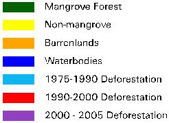
Mangrove Forest Distributions of the World
|
|
|
- Harriet Parrish
- 5 years ago
- Views:
Transcription
1 Mangrove Forest Distributions of the World Chandra Giri - ARTS/EROS/USGS Ochieng, E. - United Nations Environment Programme Larry Tieszen USGS EROS Zhiliang Zhu - USGS Ashbindu Singh United Nations Environment Programme Norman Duke University of Queensland, Australia U.S. Department of the Interior U.S. Geological Survey
2 Outline Mangrove Forest Distributions of the World GLS Data Issues
3 110, ,000 square kilometers
4 1. GLS 2. Distinct Signature!!

5 GLS plus other data e.g. Aster Converted digital numbers to the top of the atmosphere reflectance Ground truth data and existing maps and databases were used to select training samples and also for iterative labeling. true mangroves.

6 ~1,000 Landsat scenes,
7 Methodology AMCTool: Automated Mangrove Classification Tool (IDL 6.3 Envi 4.3) Landsat 6 bands Elevation NDVI NDMI Landsat Data (1990, 2000, 2005) Secondary Data High Resolution Satellite Data Co-registration Stratification PCA Difference Cloud Masking NDVI Difference Moisture Index Difference: ( , , Decision Tree Training Data & ) Classification Collection Confidence Maps (1990, 2000, 2005) Classification Results: (1990, 2000, 2005) Forest Distribution Map of 1990, 2000, 2005 Filtering Change Maps: , , Least Confident Change Most Confident Change (>70%) Least Confident No-change Most Confident No-change (>70%) Results Validation Decision Tree Extract Training Points for Classification Change and No-change Change Maps: , , Forest Change Estimates: , , Identification of Causes and Consequences of Change
8 ;NDVI expression exp_ndvi= '(b1) gt 0.10 ;NDMI Threshold expression exp_gt265='((b1) gt -0.21) and ((b1) lt 0.10) ;DEM elevation parameter exp_dem='((b1) lt 35)
9

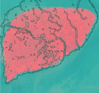
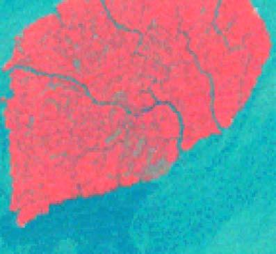
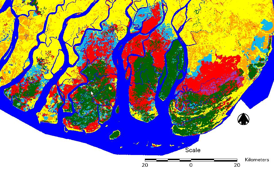
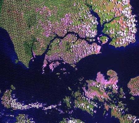
10 Mangroves & Swamp Forest Clear Boundary Swamp Forest Mangrove
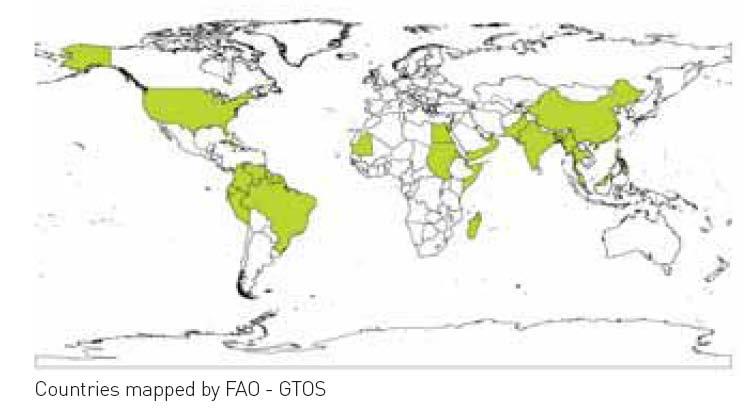
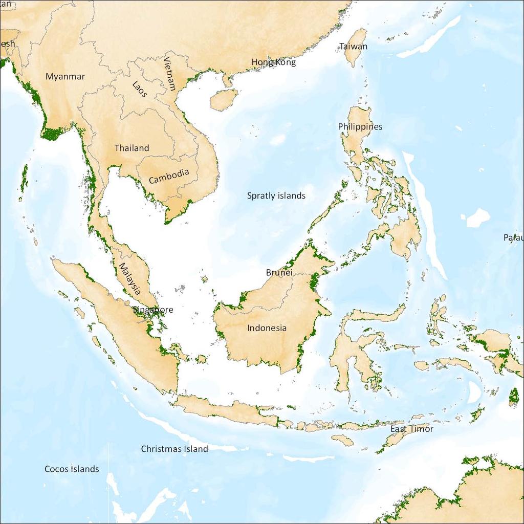
11 -First wall-to-wall map -Most comprehensive, -globally consistent - Very small areas -42% in Asia -20% in Africa -15% in North and Central America -12% in Oceania -11% in South Amerca
12
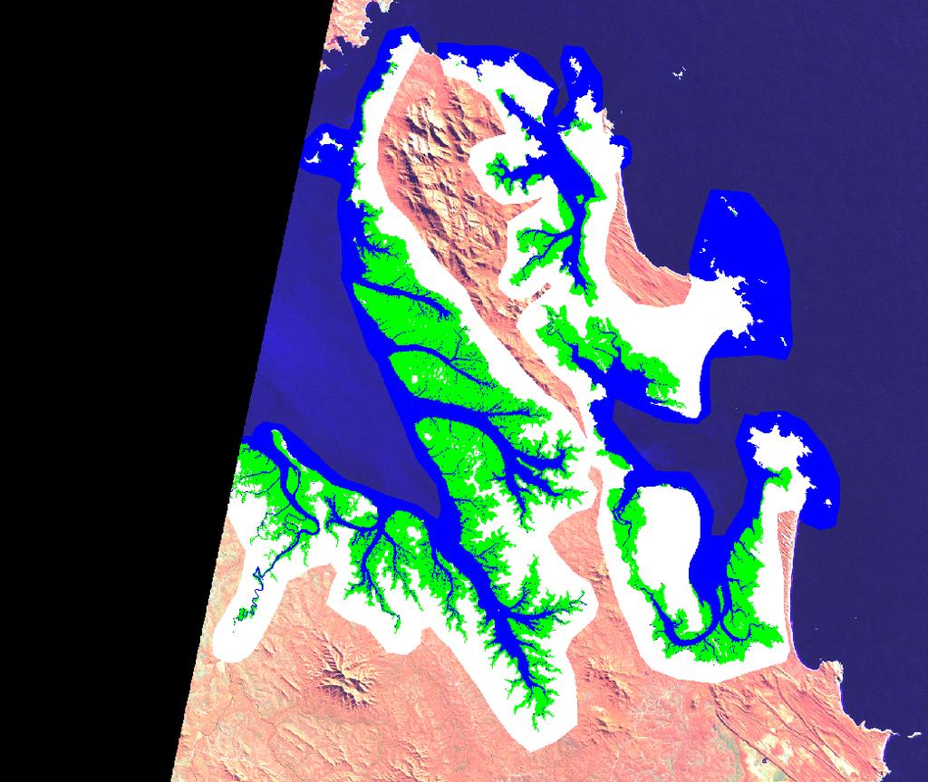
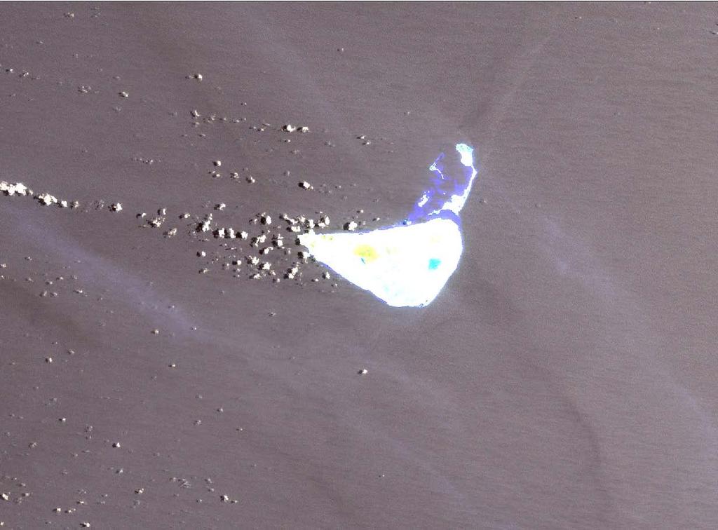
13
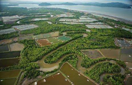
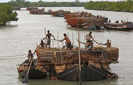
14

15 137,760 square kilometers

16 Fifteen most mangrove rich countries and their cumulative percentages
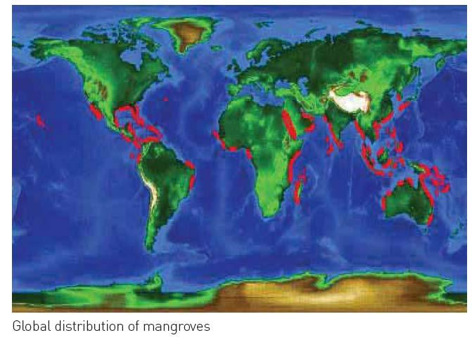
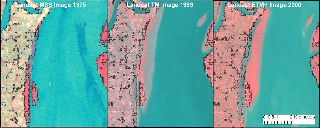
17 Our study confirms earlier findings that the biogeographic distribution of mangroves is generally confined to the tropical and subtropical regions and the largest percentage of mangrove is found between 50N and 50S latitude.
18 Major Conclusions Most comprehensive, globally consistent, and first highest resolution global map of mangrove distributions with better spatial and thematic details Area in 2000 was 137,760 square kilometers in 118 countries and territories, ~12.3% smaller than the most recent estimate by FAO 75% of world s mangroves are found in just 15 countries, Largest % are between 5 0 N and 5 0 S latitude ~6.9% is protected under the existing protected areas network (IUCN I-IV).
19 Change analysis from 1990 to 2005 Natural Anthropogenic


20 Erosion Bhangaduni Island Landsat Landsat Landsat Aggradation
21 Aquaculture Agriculture Exploitation Resort

22


23 Shrimp farms replacing mangroves in Gulf of Fonseca, Honduras : shrimp farms and ponds have mushroomed, carpeting the landscape around the Gulf of Fonseca, in blocks of blue and black shapes


24 Urban expansion near Kuala Lumpur Malaysia Landsat 1975 Landsat 2005
25 Area ('000 ha.) Year Indonesia 1 Sri Lanka 0-1 Malaysia India -2-3 Thailand Bangladesh Myanmar 100% 80% Conversion. 60% 40% 20% to other to urban to aquaculture to agriculture Mangrove forest cover change from % Thailand Malaysia Indonesia Burma Bangladesh India Sri Lanka

26
27
28
29 Present status Africa & some part of Asia is complete

30 Outreach

31 Contribution to International Programs
32 GLS Data Issues Cloud Cover Image Quality Data Gaps/Incomplete Coverage

33 Seamless data: excellent for mangrove mapping GLS 2000

34 GLS 2000 Manila Bay, Philippines

35 Stable GLS time series

36 1990 Landsat 5 TM
37 2001 Landsat 5 TM
38 2005 Landsat 7 ETM+

39 GLS 2000 GLS 2005
40 GLS-2005


41 GLS 2000 GLS 2005
42

43 1990 data in Pacific Islands
44 Recommendations for improvement Cloud free Gap Filled, GLS 2005 in tropical areas Full coverage Additional images GLOVIS Issues Data in hard disk Option of downloading multiple scenes Option of downloading a subset of a scene/scenes or subset of bands GLS data Supplemented by Landsat archive/other satellite data is needed

45 Mangroves in New Caledonia
46 Where are data gaps in the GLS datasets??how stable is the GLS time series??how are we going to handle the 1990 calibration issue??are transitions between adjacent path/rows derived from L-5 and from L7 data seamless??what is the proportion of data with poor gap-filled results? How is itcontrolled (QC)??What is proportion of path/rows with no L-5 available and no good L-7 for interpolation (gap-filled)??how consistent (in terms of season) has been scene selection??what are we missing by having such infrequent time sampling with GLS in terms of disturbance history??do we still have issues with geodetic correction? How is it in high latitudes? Ideas for future improvements? *How can we benefit from collaborations with our international partners on processing Landsat-like data?
Global Land Survey 2005
 Global Land Survey 2005 Jeff Masek, Shannon Franks, Terry Arvidson NASA GSFC Rachel Headley, Steve Covington USGS EROS April, 2008 1 Global Land Survey (GLS 2005) Follow-on to the GeoCover orthorectified
Global Land Survey Activities and Land Cover Analysis from Landsat
 Global Land Survey Activities and Land Cover Analysis from Landsat Shannon Franks, SGT/NASA Jeffrey G. Masek, NASA GSFC Garik Gutman, NASA HQ Rachel Headley, USGS CODATA, October 25, 2010 Background the
VALIDATION OF THE CLOUD AND CLOUD SHADOW ASSESSMENT SYSTEM FOR LANDSAT IMAGERY (CASA-L VERSION 1.3)
") GDA Corp. VALIDATION OF THE CLOUD AND CLOUD SHADOW ASSESSMENT SYSTEM FOR LANDSAT IMAGERY (-L VERSION 1.3) GDA Corp. has developed an innovative system for Cloud And cloud Shadow Assessment () in Landsat
GDA Corp. VALIDATION OF THE CLOUD AND CLOUD SHADOW ASSESSMENT SYSTEM FOR LANDSAT IMAGERY (-L VERSION 1.3) GDA Corp. has developed an innovative system for Cloud And cloud Shadow Assessment () in Landsat
SARscape for ENVI. A Complete SAR Analysis Solution
 SARscape for ENVI A Complete SAR Analysis Solution IDL and ENVI A Foundation for SARscape IDL The Data Analysis & Visualization Platform Data Access: IDL supports virtually every data format, type and
WGISS-42 USGS Agency Report
 WGISS-42 USGS Agency Report U.S. Department of the Interior U.S. Geological Survey Kristi Kline USGS EROS Center Major Activities Landsat Archive/Distribution Changes Land Change Monitoring, Assessment,
Using Freely Available. Remote Sensing to Create a More Powerful GIS
 Using Freely Available Government Data and Remote Sensing to Create a More Powerful GIS All rights reserved. ENVI, E3De, IAS, and IDL are trademarks of Exelis, Inc. All other marks are the property of
Improvements in Landsat Pathfinder Methods for Monitoring Tropical Deforestation and Their Extension to Extra-tropical Areas
 Improvements in Landsat Pathfinder Methods for Monitoring Tropical Deforestation and Their Extension to Extra-tropical Areas PI: John R. G. Townshend Department of Geography (and Institute for Advanced
The Landsat Legacy: Monitoring a Changing Earth. U.S. Department of the Interior U.S. Geological Survey
 The Landsat Legacy: Monitoring a Changing Earth U.S. Department of the Interior U.S. Geological Survey Tom Loveland March 17, 2001 Landsat Science Mission Change is occurring at rates unprecedented in
USGS Welcome. 38 th CEOS Working Group on Calibration and Validation Plenary (WGCV-38)
") Landsat 5 USGS Welcome Prepared for 38 th CEOS Working Group on Calibration and Validation Plenary (WGCV-38) Presenter Tom Cecere International Liaison USGS Land Remote Sensing Program Elephant Butte Reservoir
Landsat 5 USGS Welcome Prepared for 38 th CEOS Working Group on Calibration and Validation Plenary (WGCV-38) Presenter Tom Cecere International Liaison USGS Land Remote Sensing Program Elephant Butte Reservoir
White Paper. Medium Resolution Images and Clutter From Landsat 7 Sources. Pierre Missud
 White Paper Medium Resolution Images and Clutter From Landsat 7 Sources Pierre Missud Medium Resolution Images and Clutter From Landsat7 Sources Page 2 of 5 Introduction Space technologies have long been
Forest Resources Assessment using Synthe c Aperture Radar
 Forest Resources Assessment using Synthe c Aperture Radar Project Background F RA-SAR 2010 was initiated to support the Forest Resources Assessment (FRA) of the United Nations Food and Agriculture Organization
A Web Application and Subscription Service for Landsat Forest Area Change Tools (LandsatFACT)
") A Web Application and Subscription Service for Landsat Forest Area Change Tools (LandsatFACT) Development Team N.C. Forest Service: David Jones & Brian McLean UNC Asheville s NEMAC: Jim Fox, Derek Morgan,
A Web Application and Subscription Service for Landsat Forest Area Change Tools (LandsatFACT) Development Team N.C. Forest Service: David Jones & Brian McLean UNC Asheville s NEMAC: Jim Fox, Derek Morgan,
SDCG-5 Session 2. Landsat 7/8 status and 2013 Implementation Plan (Element 1)
") Session 2 Landsat 7/8 status and 2013 Implementation Plan (Element 1) Gene Fosnight Mission Landsat Launch and commissioning Landsat 7 Operational: since 15 April 1999 Expected life time:; anticipate decommissioning
Session 2 Landsat 7/8 status and 2013 Implementation Plan (Element 1) Gene Fosnight Mission Landsat Launch and commissioning Landsat 7 Operational: since 15 April 1999 Expected life time:; anticipate decommissioning
APCAS/10/21 April 2010 ASIA AND PACIFIC COMMISSION ON AGRICULTURAL STATISTICS TWENTY-THIRD SESSION. Siem Reap, Cambodia, April 2010
 APCAS/10/21 April 2010 Agenda Item 8 ASIA AND PACIFIC COMMISSION ON AGRICULTURAL STATISTICS TWENTY-THIRD SESSION Siem Reap, Cambodia, 26-30 April 2010 The Use of Remote Sensing for Area Estimation by Robert
The availability of cloud free Landsat TM and ETM+ land observations and implications for global Landsat data production
 14475 The availability of cloud free Landsat TM and ETM+ land observations and implications for global Landsat data production *V. Kovalskyy, D. Roy (South Dakota State University) SUMMARY The NASA funded
Earth Observations from Space U.S. Geological Survey
 Earth Observations from Space U.S. Geological Survey Geography Land Remote Sensing Program Dr. Bryant Cramer April 1, 2009 U.S. Department of the Interior U.S. Geological Survey USGS Landsat Historical
GIS Data Collection. Remote Sensing
 GIS Data Collection Remote Sensing Data Collection Remote sensing Introduction Concepts Spectral signatures Resolutions: spectral, spatial, temporal Digital image processing (classification) Other systems
Documenting Land Cover and Vegetation Productivity Changes in the NWT using the Landsat Satellite Archive
 Documenting Land Cover and Vegetation Productivity Changes in the NWT using the Landsat Satellite Archive Fraser, R.H 1, Olthof, I. 1, Deschamps, A. 1, Pregitzer, M. 1, Kokelj, S. 2, Lantz, T. 3,Wolfe,
Background Objectives Study area Methods. Conclusions and Future Work Acknowledgements
 A DIGITAL PROCESSING AND DATA COMPILATION APPROACH FOR USING REMOTELY SENSED IMAGERY TO IDENTIFY GEOLOGICAL LINEAMENTS IN HARD-ROCK ROCK TERRAINS: AN APPLICATION FOR GROUNDWATER EXPLORATION IN NICARAGUA
Central Platte Natural Resources District-Remote Sensing/Satellite Evapotranspiration Project. Progress Report September 2009 TABLE OF CONTENTS
 Central Platte Natural Resources District-Remote Sensing/Satellite Evapotranspiration Project Progress Report September 2009 Ayse Irmak, Ph.D. Assistant Professor School of Natural Resources, Department
In late April of 1986 a nuclear accident damaged a reactor at the Chernobyl nuclear
 CHERNOBYL NUCLEAR POWER PLANT ACCIDENT Long Term Effects on Land Use Patterns Project Introduction: In late April of 1986 a nuclear accident damaged a reactor at the Chernobyl nuclear power plant in Ukraine.
29 th Annual Louisiana RS/GIS Workshop April 23, 2013 Cajundome Convention Center Lafayette, Louisiana
 Landsat Data Continuity Mission 29 th Annual Louisiana RS/GIS Workshop April 23, 2013 Cajundome Convention Center Lafayette, Louisiana http://landsat.usgs.gov/index.php# Landsat 5 Sets Guinness World Record
LANDSAT 8 Level 1 Product Performance
 Réf: IDEAS-TN-10-CyclicReport LANDSAT 8 Level 1 Product Performance Cyclic Report Month/Year: May 2015 Date: 25/05/2015 Issue/Rev:1/0 1. Scope of this document On May 30, 2013, data from the Landsat 8
Please show the instructor your downloaded index files and orthoimages.
 Student Exercise 1: Sandia Forest Infestation Acquiring Orthophotos and Satellite Imagery Please show the instructor your downloaded index files and orthoimages. Objectives: Determine appropriate imagery
DISTINGUISHING URBAN BUILT-UP AND BARE SOIL FEATURES FROM LANDSAT 8 OLI IMAGERY USING DIFFERENT DEVELOPED BAND INDICES
 DISTINGUISHING URBAN BUILT-UP AND BARE SOIL FEATURES FROM LANDSAT 8 OLI IMAGERY USING DIFFERENT DEVELOPED BAND INDICES Mark Daryl C. Janiola (1), Jigg L. Pelayo (1), John Louis J. Gacad (1) (1) Central
An Introduction to Remote Sensing & GIS. Introduction
 An Introduction to Remote Sensing & GIS Introduction Remote sensing is the measurement of object properties on Earth s surface using data acquired from aircraft and satellites. It attempts to measure something
TEMPORAL ANALYSIS OF MULTI EPOCH LANDSAT GEOCOVER IMAGES IN ZONGULDAK TESTFIELD
 TEMPORAL ANALYSIS OF MULTI EPOCH LANDSAT GEOCOVER IMAGES IN ZONGULDAK TESTFIELD Şahin, H. a*, Oruç, M. a, Büyüksalih, G. a a Zonguldak Karaelmas University, Zonguldak, Turkey - (sahin@karaelmas.edu.tr,
Remote Sensing for Rangeland Applications
 Remote Sensing for Rangeland Applications Jay Angerer Ecological Training June 16, 2012 Remote Sensing The term "remote sensing," first used in the United States in the 1950s by Ms. Evelyn Pruitt of the
Separation of crop and vegetation based on Digital Image Processing
 Separation of crop and vegetation based on Digital Image Processing Mayank Singh Sakla 1, Palak Jain 2 1 M.TECH GEOMATICS student, CEPT UNIVERSITY 2 M.TECH GEOMATICS student, CEPT UNIVERSITY Word Limit
Update on Landsat Program and Landsat Data Continuity Mission
 Update on Landsat Program and Landsat Data Continuity Mission Dr. Jeffrey Masek LDCM Deputy Project Scientist NASA GSFC, Code 923 November 21, 2002 Draft LDCM Implementation Phase RFP Overview Page 1 Celebrate!
A Digital Processing & Data Compilation Approach for Using Remotely Sensed Imagery to Identify Geological Lineaments In Hard-rock Terrains:
 A Digital Processing & Data Compilation Approach for Using Remotely Sensed Imagery to Identify Geological Lineaments In Hard-rock Terrains: An Application For Groundwater Exploration In Nicaragua Jill
The Global Mangrove Watch
 The Global Mangrove Watch Annual mapping of the status and changes of the world s mangroves Ake Rosenqvist and Masanobu Shimada (JAXA/Japan) Richard Lucas (Aberystwyth Univ./U.K.) Lisa Maria Rebelo (IWMI/Lao
NASA Missions and Products: Update. Garik Gutman, LCLUC Program Manager NASA Headquarters Washington, DC
 NASA Missions and Products: Update Garik Gutman, LCLUC Program Manager NASA Headquarters Washington, DC 1 JPSS-2 (NOAA) SLI-TBD Formulation in 2015 RBI OMPS-Limb [[TSIS-2]] [[TCTE]] Land Monitoring at
Field size estimation, past and future opportunities
 Field size estimation, past and future opportunities Lin Yan & David Roy Geospatial Sciences Center of Excellence South Dakota State University February 13-15 th 2018 Advances in Emerging Technologies
Activity Data (AD) Monitoring in the frame of REDD+ MRV
 Monitoring in the frame of REDD+ MRV") Activity Data (AD) Monitoring in the frame of REDD+ MRV Preliminary comments REDD+ is sustainable low emissions, high carbon rural development Monitoring efforts should support this effort Challenges Diversity
Activity Data (AD) Monitoring in the frame of REDD+ MRV Preliminary comments REDD+ is sustainable low emissions, high carbon rural development Monitoring efforts should support this effort Challenges Diversity
Review of the WCA 2010 implementation experiences
 Technical Review Meeting on the World Programme for the Census of Agriculture (WCA) 2020 Rome, Italy 7-8 November 2014 Review of the WCA 2010 implementation experiences Miguel Galmes Consulant, Agricultural
PROGRESS IN ADDRESSING SCIENCE GOALS FOR GLACIER OBSERVATIONS BY MEANS OF SAR
 PROGRESS IN ADDRESSING SCIENCE GOALS FOR GLACIER OBSERVATIONS BY MEANS OF SAR Frank Paul, Thomas Nagler, Dana Floricioiu, et al. PSTG, 13/9/2016 Panmah, Karakoram Observed glacier products and sensors
PROGRESS IN ADDRESSING SCIENCE GOALS FOR GLACIER OBSERVATIONS BY MEANS OF SAR. Frank Paul & Thomas Nagler
 PROGRESS IN ADDRESSING SCIENCE GOALS FOR GLACIER OBSERVATIONS BY MEANS OF SAR Frank Paul & Thomas Nagler SAR Coordination Working Group Meeting, 13/11/2016 Observed glacier products and sensors Product
Remote Sensing in an
 Chapter 8. Downloading Landsat Imagery using Earth Explorer Remote Sensing in an ArcMap Environment Remote Sensing Analysis in an ArcMap Environment Tammy E. Parece Image source: landsat.usgs.gov Tammy
A Project to Map and Monitor Baldcypress Forests in Coastal Louisiana, using Landsat, MODIS, and ASTER Satellite Data
 A Project to Map and Monitor Baldcypress Forests in Coastal Louisiana, using Landsat, MODIS, and ASTER Satellite Data Presented to the 2012 Louisiana RS/GIS Workshop by: Joseph Spruce, Computer Sciences
MRLC 2001 IMAGE PREPROCESSING PROCEDURE
 MRLC 2001 IMAGE PREPROCESSING PROCEDURE The core dataset of the MRLC 2001 database consists of Landsat 7 ETM+ images. Image selection is based on vegetation greenness profiles defined by a multi-year normalized
ENVI Orthorectification Module
 ENVI Orthorectification Module Orthorectify your imagery quickly and easily. CREASO - your partner for visual information solutions Rigorous Orthorectification. Simple Workflow. Trusted Method. The Need
A Thesis submitted in partial fulfillment of the requirements for the degree of Master of Science at George Mason University
 Change Detection and Remote Sensing Methodologies to Track Deforestation and Growth in Threatened Global Rainforests A Thesis submitted in partial fulfillment of the requirements for the degree of Master
CanImage. (Landsat 7 Orthoimages at the 1: Scale) Standards and Specifications Edition 1.0
 Standards and Specifications Edition 1.0") CanImage (Landsat 7 Orthoimages at the 1:50 000 Scale) Standards and Specifications Edition 1.0 Centre for Topographic Information Customer Support Group 2144 King Street West, Suite 010 Sherbrooke, QC
CanImage (Landsat 7 Orthoimages at the 1:50 000 Scale) Standards and Specifications Edition 1.0 Centre for Topographic Information Customer Support Group 2144 King Street West, Suite 010 Sherbrooke, QC
ASTER GDEM Readme File ASTER GDEM Version 1
 I. Introduction ASTER GDEM Readme File ASTER GDEM Version 1 The Advanced Spaceborne Thermal Emission and Reflection Radiometer (ASTER) Global Digital Elevation Model (GDEM) was developed jointly by the
Instructions for assembling your Asia Lapbook:
 Instructions for assembling your Asia Lapbook: Supplies needed: File folder paper and/or cardstock scissors hole puncher gluestick or glue dots or two sided tape stapler Printing: Most items are fine if
Vegetation Phenology. Quantifying climate impacts on ecosystems: Field and Satellite Assessments
 Vegetation Phenology Quantifying climate impacts on ecosystems: Field and Satellite Assessments Plants can tell us a story about climate. Timing of sugar maple leaf drop (Ollinger, S.V. Potential effects
The Normal Baseline. Dick Gent Law of the Sea Division UK Hydrographic Office
 The Normal Baseline Dick Gent Law of the Sea Division UK Hydrographic Office 2 The normal baseline for measuring the breadth of the territorial sea is the low water line along the coast as marked on large
ENVI Orthorectification Module
 Visual Information Solutions ENVI Orthorectification Module Orthorectify Your Imagery Quickly and Easily. Rigorous Orthorectification. Simple Workflow. Trusted Method. The Need for Orthorectification Satellite
Developing land cover products in Monsoon Asia through integration of Landsat (GLS2005) and L-band PALSAR imagery: --- An Update
 and L-band PALSAR imagery: --- An Update") Developing land cover products in Monsoon Asia through integration of Landsat (GLS2005) and L-band PALSAR imagery: --- An Update Landsat 7 ETM+ PALSAR Xiangming Xiao Center for Spatial Analysis, University
Developing land cover products in Monsoon Asia through integration of Landsat (GLS2005) and L-band PALSAR imagery: --- An Update Landsat 7 ETM+ PALSAR Xiangming Xiao Center for Spatial Analysis, University
A Study of the Mississippi River Delta Using Remote Sensing
 1 University of Puerto Rico Mayagüez Campus PO BOX 9000 Mayagüez PR 00681-9000 Tel: (787) 832-4040 A Study of the Mississippi River Delta Using Remote Sensing Meganlee Rivera 1, Imaryarie Rivera 1 Department
Overview of available data and data sources on birth registration. Claudia Cappa Data & Analytics Section, UNICEF
 Overview of available data and data sources on birth registration Claudia Cappa Data & Analytics Section, UNICEF Outline Overview of available data and data sources on birth registration Presentation of
Land Cover Change in Saipan, CNMI from 1978 to 2009
 International Journal of Environment and Resource Volume 5, 2016 doi: 10.14355/ijer.2016.05.002 www.ij-er.org Land Cover Change in Saipan, CNMI from 1978 to 2009 Yuming Wen *1, Derek Chambers 2 1 Water
University of Texas at San Antonio EES 5053 Term Project CORRELATION BETWEEN NDVI AND SURFACE TEMPERATURES USING LANDSAT ETM + IMAGERY NEWFEL MAZARI
 University of Texas at San Antonio EES 5053 Term Project CORRELATION BETWEEN NDVI AND SURFACE TEMPERATURES USING LANDSAT ETM + IMAGERY NEWFEL MAZARI Introduction and Objectives The present study is a correlation
Remote Sensing Mapping of Turbidity in the Upper San Francisco Estuary. Francine Mejia, Geography 342
 Remote Sensing Mapping of Turbidity in the Upper San Francisco Estuary Francine Mejia, Geography 342 Introduction The sensitivity of reflectance to sediment, chlorophyll a, and colored DOM (CDOM) in the
NON-PHOTOGRAPHIC SYSTEMS: Multispectral Scanners Medium and coarse resolution sensor comparisons: Landsat, SPOT, AVHRR and MODIS
 NON-PHOTOGRAPHIC SYSTEMS: Multispectral Scanners Medium and coarse resolution sensor comparisons: Landsat, SPOT, AVHRR and MODIS CLASSIFICATION OF NONPHOTOGRAPHIC REMOTE SENSORS PASSIVE ACTIVE DIGITAL
Malaria Vector in Northeastern Venezuela. Sarah Anne Guagliardo MPH candidate, 2010 Yale University School of Epidemiology and Public Health
 Vegetation associated with the An. Aquasalis Malaria Vector in Northeastern Venezuela Sarah Anne Guagliardo g MPH candidate, 2010 Yale University School of Epidemiology and Public Health Outline Problem
Overview. Introduction. Elements of Image Interpretation. LA502 Special Studies Remote Sensing
 LA502 Special Studies Remote Sensing Elements of Image Interpretation Dr. Ragab Khalil Department of Landscape Architecture Faculty of Environmental Design King AbdulAziz University Room 103 Overview Introduction
At-Satellite Reflectance: A First Order Normalization Of Landsat 7 ETM+ Images
 University of Nebraska - Lincoln DigitalCommons@University of Nebraska - Lincoln Publications of the US Geological Survey US Geological Survey 21 At-Satellite Reflectance: A First Order Normalization Of
Using Web-based Tools for GIS-Friendly Satellite Imagery
 Using Web-based Tools for GIS-Friendly Satellite Imagery Lindsey Harriman SGT, Contractor to the USGS EROS Center, Sioux Falls, South Dakota **Work performed under USGS contract G10PC00044 U.S. Department
Regional Course on Integrated Economic Statistics to Support 2008 SNA Implementation
 Regional Course on Integrated Economic Statistics to Support 2008 SNA Implementation A review of Economic Censuses and their role in national economic statistics 18-21 April 2017, Bangkok, Thailand Alick
1. Background Overview
 Technical Contributions to Spectrum Sharing Regulators Ryu Miura, Takayuki Morisaki, and Masayuki Oodo National Institute of Information and Communications Technology (NICT), 1 1. Background Overview 2
Lesson 3: Working with Landsat Data
 Lesson 3: Working with Landsat Data Lesson Description The Landsat Program is the longest-running and most extensive collection of satellite imagery for Earth. These datasets are global in scale, continuously
Removing Thick Clouds in Landsat Images
 Removing Thick Clouds in Landsat Images S. Brindha, S. Archana, V. Divya, S. Manoshruthy & R. Priya Dept. of Electronics and Communication Engineering, Avinashilingam Institute for Home Science and Higher
GE 113 REMOTE SENSING
 GE 113 REMOTE SENSING Topic 8. Image Classification and Accuracy Assessment Lecturer: Engr. Jojene R. Santillan jrsantillan@carsu.edu.ph Division of Geodetic Engineering College of Engineering and Information
REMOTE SENSING. Topic 10 Fundamentals of Digital Multispectral Remote Sensing MULTISPECTRAL SCANNERS MULTISPECTRAL SCANNERS
 REMOTE SENSING Topic 10 Fundamentals of Digital Multispectral Remote Sensing Chapter 5: Lillesand and Keifer Chapter 6: Avery and Berlin MULTISPECTRAL SCANNERS Record EMR in a number of discrete portions
Introduction of Satellite Remote Sensing
 Introduction of Satellite Remote Sensing Spatial Resolution (Pixel size) Spectral Resolution (Bands) Resolutions of Remote Sensing 1. Spatial (what area and how detailed) 2. Spectral (what colors bands)
GAGAN-Extension to the Gulf Region. Joint ACAC/ICAO MID Workshop on GNSS 7 th & 8 th November 2017
 GAGAN-Extension to the Gulf Region Joint ACAC/ICAO MID Workshop on GNSS 7 th & 8 th November 2017 P.N.S. KUSHWAHA EXECUTIVE DIRECTOR (CNS P) Airports Authority of India New Delhi Topics covered : 1. GAGAN
UNOSAT Satellite Imagery and GIS Solutions for DRR and Emergency Management
 UNOSAT Satellite Imagery and GIS Solutions for DRR and Emergency Management Francesco Pisano Director, Research, Technology Applications & Knowledge Systems January 2013 Introduction to UNOSAT 2 About
Land Remote Sensing Lab 4: Classication and Change Detection Assigned: October 15, 2017 Due: October 27, Classication
 Name: Land Remote Sensing Lab 4: Classication and Change Detection Assigned: October 15, 2017 Due: October 27, 2017 In this lab, you will generate several gures. Please sensibly name these images, save
NORMALIZING ASTER DATA USING MODIS PRODUCTS FOR LAND COVER CLASSIFICATION
 NORMALIZING ASTER DATA USING MODIS PRODUCTS FOR LAND COVER CLASSIFICATION F. Gao a, b, *, J. G. Masek a a Biospheric Sciences Branch, NASA Goddard Space Flight Center, Greenbelt, MD 20771, USA b Earth
Keywords: Agriculture, Olive Trees, Supervised Classification, Landsat TM, QuickBird, Remote Sensing.
 Classification of agricultural fields by using Landsat TM and QuickBird sensors. The case study of olive trees in Lesvos island. Christos Vasilakos, University of the Aegean, Department of Environmental
Wetlands Investigation Utilizing GIS and Remote Sensing Technology for Lucas County, Ohio: a hybrid analysis.
 Wetlands Investigation Utilizing GIS and Remote Sensing Technology for Lucas County, Ohio: a hybrid analysis. Update on current wetlands research in GISAG Nathan Torbick Spring 2003 Component One Remote
ESTIMATING REEF HABITAT COVERAGE SUITABLE FOR THE HUMPHEAD WRASSE, CHEILINUS UNDULATUS, USING REMOTE SENSING
 FAO Fisheries and Aquaculture Circular No. 1057 FIRF/C1057 (En) ISSN 2070-6065 ESTIMATING REEF HABITAT COVERAGE SUITABLE FOR THE HUMPHEAD WRASSE, CHEILINUS UNDULATUS, USING REMOTE SENSING Copies of FAO
Acquisition of Aerial Photographs and/or Satellite Imagery
 Acquisition of Aerial Photographs and/or Satellite Imagery Acquisition of Aerial Photographs and/or Imagery From time to time there is considerable interest in the purchase of special-purpose photography
Remote Sensing. The following figure is grey scale display of SPOT Panchromatic without stretching.
 Remote Sensing Objectives This unit will briefly explain display of remote sensing image, geometric correction, spatial enhancement, spectral enhancement and classification of remote sensing image. At
Combined Use of SAR and Optical Time Series Data towards Near Real-Time Forest Disturbance Mapping
 Background Image Source bbc.co.uk Human Planet 2011 BBC Manuela Hirschmugl, Janik Deutscher, Karl-Heinz Gutjahr, Carina Sobe, Mathias Schardt Joanneum Research Earth Observation Services for Monitoring
9/13/2011. Training Course Remote Sensing Basic Theory & Image Processing Methods September 2011
 Training Course Remote Sensing Basic Theory & Image Processing Methods 19 23 September 2011 DIGITAL TERRAIN MODELS Introduction Michiel Damen (April 2011) damen@itc.nl 1 Digital Elevation and Terrain Models
Image Registration Issues for Change Detection Studies
 Image Registration Issues for Change Detection Studies Steven A. Israel Roger A. Carman University of Otago Department of Surveying PO Box 56 Dunedin New Zealand israel@spheroid.otago.ac.nz Michael R.
- Avenues and Requisites for Successful Collaboration - Indian Space Research Organisation Department of Space Government of India
 Strengthening Regional Resilience with Geo-Information Programme on Trans-boundary Cooperation in South and South East Asia for geospatial information - Avenues and Requisites for Successful Collaboration
Urban Classification of Metro Manila for Seismic Risk Assessment using Satellite Images
 Urban Classification of Metro Manila for Seismic Risk Assessment using Satellite Images Fumio YAMAZAKI/ yamazaki@edm.bosai.go.jp Hajime MITOMI/ mitomi@edm.bosai.go.jp Yalkun YUSUF/ yalkun@edm.bosai.go.jp
How to Access Imagery and Carry Out Remote Sensing Analysis Using Landsat Data in a Browser
 How to Access Imagery and Carry Out Remote Sensing Analysis Using Landsat Data in a Browser Including Introduction to Remote Sensing Concepts Based on: igett Remote Sensing Concept Modules and GeoTech
Remote sensing in archaeology from optical to lidar. Krištof Oštir ModeLTER Scientific Research Centre of the Slovenian Academy of Sciences and Arts
 Remote sensing in archaeology from optical to lidar Krištof Oštir ModeLTER Scientific Research Centre of the Slovenian Academy of Sciences and Arts Introduction Optical remote sensing Systems Search for
Abstract Urbanization and human activities cause higher air temperature in urban areas than its
 Observe Urban Heat Island in Lucas County Using Remote Sensing by Lu Zhao Table of Contents Abstract Introduction Image Processing Proprocessing Temperature Calculation Land Use/Cover Detection Results
Development of normalized vegetation, soil and water indices derived from satellite remote sensing data
 Development of normalized vegetation, soil and water indices derived from satellite remote sensing data Takeuchi, W. & Yasuoka, Y. IIS/UT, Japan E-mail: wataru@iis.u-tokyo.ac.jp Nov. 25th, 2004 ACRS2004
Data acquisition and access for the Congo Basin
 MRV Joint Workshop 22-24 June 2010, Guadalajara, Jalisco Mexico Data acquisition and access for the Congo Basin Landing Mané 1, Michael Brady 2, Chris Justice 3 and Alice Altstatt 3 1) Satellite Observatory
Sommersemester Prof. Dr. Christoph Kleinn Institut für Waldinventur und Waldwachstum Arbeitsbereich Fernerkundung und Waldinventur.
 Basics of Remote Sensing Some literature references Franklin, SE 2001 Remote Sensing for Sustainable Forest Management Lewis Publishers 407p Lillesand, Kiefer 2000 Remote Sensing and Image Interpretation
DEVELOPMENT OF A NEW SOUTH AFRICAN LAND-COVER DATASET USING AUTOMATED MAPPING TECHINQUES. Mark Thompson 1
 DEVELOPMENT OF A NEW SOUTH AFRICAN LAND-COVER DATASET USING AUTOMATED MAPPING TECHINQUES. Mark Thompson 1 1 GeoTerraImage Pty Ltd, Pretoria, South Africa Abstract This talk will discuss the development
Comparing of Landsat 8 and Sentinel 2A using Water Extraction Indexes over Volta River
 Journal of Geography and Geology; Vol. 10, No. 1; 2018 ISSN 1916-9779 E-ISSN 1916-9787 Published by Canadian Center of Science and Education Comparing of Landsat 8 and Sentinel 2A using Water Extraction
Geocoding DoubleCheck: A Unique Location Accuracy Assessment Tool for Parcel-level Geocoding
 Measuring, Modelling and Mapping our Dynamic Home Planet Geocoding DoubleCheck: A Unique Location Accuracy Assessment Tool for Parcel-level Geocoding Page 1 Geocoding is a process of converting an address
Global Land Survey Update. Jeff Masek, NASA GSFC Rachel Headley, USGS EROS
 Global Land Survey Update Jeff Masek, NASA GSFC Rachel Headley, USGS EROS Outline Global Land Survey 2010 USGS Landsat Global Archive Consolidation NGA Commercial Imagery Background: Global Land Survey
The first part of Module three, data and tools, presents some of the resources available on the internet to get images from the satellites presented
 The first part of Module three, data and tools, presents some of the resources available on the internet to get images from the satellites presented in the previous module and some uses of the images,
Our Quality Promise WHITE PAPER
 Our Quality Promise www.digitalglobe.com Corporate (U.S.) +1.303.684.4561 or +1.800.496.1225 London +44.20.8899.6801 Singapore +65.6389.4851 To ensure your success, we put quality at our core At DigitalGlobe,
Remote Sensing Part 3 Examples & Applications
 Remote Sensing Part 3 Examples & Applications Review: Spectral Signatures Review: Spectral Resolution Review: Computer Display of Remote Sensing Images Individual bands of satellite data are mapped to
Downloading Imagery & LIDAR
 Downloading Imagery & LIDAR 333 Earth Explorer The USGS is a great source for downloading many different GIS data products for the entire US and Canada and much of the world. Below are instructions for
AT-SATELLITE REFLECTANCE: A FIRST ORDER NORMALIZATION OF LANDSAT 7 ETM+ IMAGES
 AT-SATELLITE REFLECTANCE: A FIRST ORDER NORMALIZATION OF LANDSAT 7 ETM+ IMAGES Chengquan Huang*, Limin Yang, Collin Homer, Bruce Wylie, James Vogelman and Thomas DeFelice Raytheon ITSS, EROS Data Center
366 Glossary. Popular method for scale drawings in a computer similar to GIS but without the necessity for spatial referencing CEP
 366 Glossary GISci Glossary ASCII ASTER American Standard Code for Information Interchange Advanced Spaceborne Thermal Emission and Reflection Radiometer Computer Aided Design Circular Error Probability
Mainstreaming Air Quality in Urban Development through South South Twinning
 Completion Report Project Number: 46250-001 Technical Assistance Number: 8751 March 2018 Mainstreaming Air Quality in Urban Development through South South Twinning This document is being disclosed to
Using Landsat Imagery to Monitor Post-Fire Vegetation Recovery in the Sandhills of Nebraska: A Multitemporal Approach.
 University of Nebraska - Lincoln DigitalCommons@University of Nebraska - Lincoln Environmental Studies Undergraduate Student Theses Environmental Studies Program Spring 5-2012 Using Landsat Imagery to
ASSESSMENT OF THE TOURISM POTENTIAL OF TERRESTRIAL/WETLAND SITES IN MALAYSIA
 ASSESSMENT OF THE TOURISM POTENTIAL OF TERRESTRIAL/WETLAND SITES IN MALAYSIA YEAP CHIN AIK (Malaysian Nature Society) Ramsar Pre-COP11 Regional Meeting, 14-18 November 2011, Jakarta IN SEARCH OF BIRDS