GAGAN-Extension to the Gulf Region. Joint ACAC/ICAO MID Workshop on GNSS 7 th & 8 th November 2017
|
|
|
- Hector Lane
- 5 years ago
- Views:
Transcription
1 GAGAN-Extension to the Gulf Region Joint ACAC/ICAO MID Workshop on GNSS 7 th & 8 th November 2017 P.N.S. KUSHWAHA EXECUTIVE DIRECTOR (CNS P) Airports Authority of India New Delhi

2 Topics covered : 1. GAGAN program Implantation schedule. 2. GAGAN Architecture. 3. GAGAN Services & status. 4. GAGAN Performance & Ongoing Activities. 5. Extension GAGAN services to neighbouring regions. 6. Additional Services planned to be offered through GAGAN
 Aug 2004 to August 2007. Phase II : Final Operation Phase (FOP) June 2009 to June 2013.")
3 GAGAN Program Implementation Schedule Jointly developed by AAI and ISRO. Implemented in two phases: Phase I : Technology Demonstration of System (TDS) Aug 2004 to August Phase II : Final Operation Phase (FOP) June 2009 to June Certification: Certified by DGCA, India for RNP 0.1 on 30 th December 2013 APV I on 21 st April 2015
4 A. Ground segment 1. Reference stations (INRES) 15 Nos 2. Master Control Center (INMCC) 3 Nos 3. Uplink Stations (INLUS) 3 Nos 4. Redundant data links between GAGAN sites. Jaisalm er Jammu Delhi Gaya GAGAN GAGAN Elements INRES Sites D ibruga rh Guwahati Patna Porband ar Ahm eda bad N agpur Calcutta B hubanes w ar B. Space segment 1. GPS Constellation 2. GEO Satellites with nav payload 3 no s GOA C. User segment GAGAN enabled SBAS Rx. B angalor e Port Blai r Tr ivandrum
 INMCC #1 (BG) INMCC #2 (BG) INMCC #3 (DD) DATA COMMUNICATION NETWORK @ 2Mbps 128 Kbps (OFC & V Sat Dual Link) INRES-1 INRES-2")
5 GAGAN Architecture GSAT-8 GSAT-10 GSAT-15 GPS 1 to 32 SIS with PRN 127 SIS with PRN 128 SIS with PRN 132 INLUS #1 PRN 127(BG) INLUS #2 PRN128 (BG) INLUS #3 PRN 127 (DD) DATA COMMUNICATION 2 Mbps / 128 Kbps (OFC Link) INMCC #1 (BG) INMCC #2 (BG) INMCC #3 (DD) DATA COMMUNICATION 2Mbps 128 Kbps (OFC & V Sat Dual Link) INRES-1 INRES-2 INRES-15
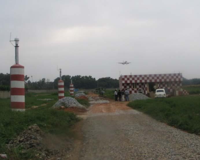
6 GAGAN Infrastructure INRES
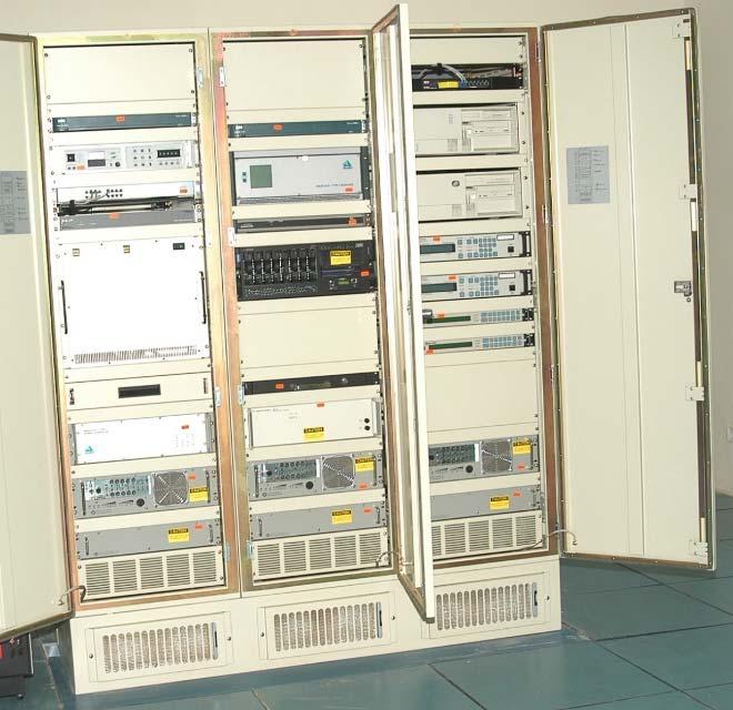
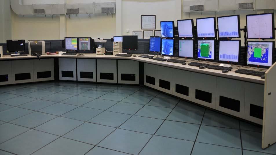
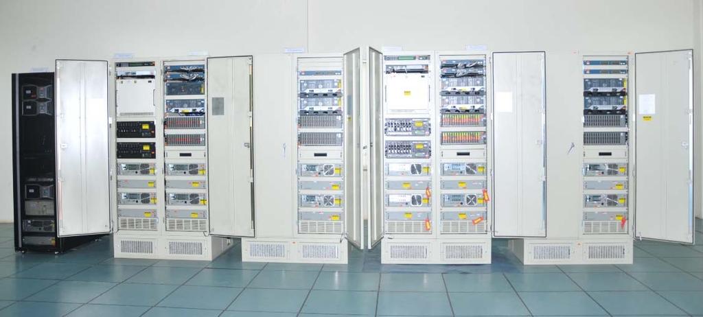
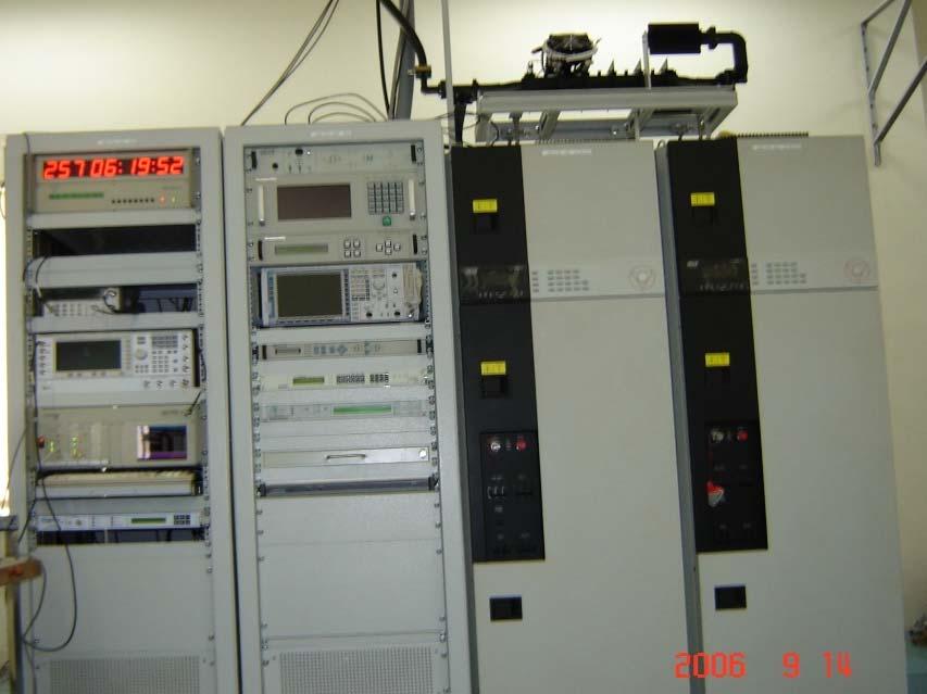
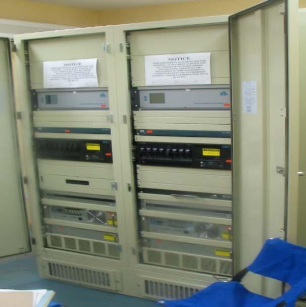
7 GAGAN Infrastructure INMCC & INLUS Equipment INMCC CVSS and DCSS INLUS


8 GAGAN Infrastructure Building & Antenna Structures INMCC CTF BUILDING AT BANGALORE INRES Facility At Bangalore 1 INLUS 11 MTR ANTENNA AT BANGALORE VSAT ANTENNA (6.3M DIA) AT BANGALORE


 Integrations activities with third GEO satellite GSAT 15")
9 GAGAN Services & Status GAGAN provides the following air navigation services meeting ICAO SARPS. RNP 0.1 within India FIR APV 1 in the landmass of Indian FIR. (Due to impact of ionosphere behavior over the equatorial regions, availability of GAGAN APV 1 service is better than 76% of landmass on nominal iono days. Current Transmission is on GSAT 8 (PRN 127) & GSAT 10 (PRN 128) Integrations activities with third GEO satellite GSAT 15 (PRN 132) are in progress. Expected to be completed by July 2018.
 APV 1")

10 24 hours Service Availability plot (24 th Oct. 2017, 00:00 to 23:59 UTC) APV 1 Service RNP 0.1 Service GAGAN Real time system performance is available at

11 IGP s serviced in the existing GAGAN system

12 Existing GAGAN RNP 0.1 Coverage beyond the Indian Region
13 GAGAN Performance during last one year Average Availability value of RNP0.1 service is 100% of Indian FIRs. Average Availability value of APV 1.0 service is better than 76% of Indian Landmass during nominal days of ionosphere activity.
14 Promotional Activities in India User Segment As per National Civil Aviation Policy (NCAP 2016), Aviation, India mandated that: Ministry of Civil All new aircraft, registered in India to be GAGAN enabled from 1 st January Forward fit notification by DGCA very soon, as per NCAP 2016 All aircraft, registered in India, to be GAGAN enabled from DGCA, India to provide necessary amendments in CAR, CAP and Airworthiness Procedure Manual (APM)


15 Works in Hand Development of APV procedures for 20 Airports are in the progress. The APV procedure for 3 airports i.e. Ahmedabad, Lucknow and Nagpur has been developed. Testing & validation of these procedures is being taken up shortly. In the next few years, GAGAN APV procedures development for almost all operational airports in India. GSAT 15 integration. FURURE PLANS: Expansion of GAGAN Services to Neighboring Countries having GAGAN GEO Foot prints.
16 Suitability of GAGAN in the Gulf region Both India and Gulf regions are on equatorial anomaly region. Ionosphere Scintillation is most intense and most frequent in the equatorial region. Ionosphere Scintillation severely affects the performance of SBAS. An MLDF (Multi Layer Data Fusion) iono model suitable to serve the equatorial anomaly region was developed by ISRO and implemented in GAGAN system. Gulf region falls within the GAGAN GEO foot print.


17 Extension of the GAGAN services to Gulf region GAGAN GEO footprint extends from Africa to Australia. In the existing GAGAN system 102 IGP s are serviced and RNP 0.1 coverage is available much beyond the Indian region. GAGAN system can support up to 45 reference stations. By installing additional reference stations at strategic locations in gulf region and forward the measurements data to GAGAN INMCC, more IGP s can be serviced and RNP 0.1/APV 1 services can be extended to gulf region.
18 Major Activities Involved to add reference stations for extension of GAGAN services Indentify strategic locations and conduct a preliminary site survey. Carry out Multipath, RF Interference survey & elevation profile at the identified sites. Develop necessary Civil and electrical infrastructure at the selected site. Establish reliable data links between reference station and master control center. Conduct data links testing. One way latency of satellite links should be less than 500 msec. Procure the Reference station equipment. Install and Test the Reference equipment at site. Integrate with Master control center and conduct stability test. Safety analysis, Documentation. Certification by the regulator.
19 AAI, as GAGAN service provider has the capability of Reference stations sites selection and identification of site infrastructure requirement. Engineering Support for Site infrastructure development. Installation & testing of reference stations and test reports generation. Support to establish & test data communication links to Master Control Center. Integrate reference station with Indian Master Control center Carryout Stability test, test reports generation Support for certification. Train personnel for operation and maintenance. Evaluation of SBAS SIS Strengths of AAI ISRO Neighboring states can take advantage of GAGAN infrastructure to implement the RNP 0.1 and APV 1 service in the respective states without having the full SBAS infrastructure in their country. GAGAN has become the third in the world to have such Precision Approach Capability.
20 Additional Service Planned GAGAN MESSAGE SERVICE (GAMES) Plan to utilize GAGAN signals for broadcasting short service messages with suitable changes in the message structure via GEO satellites. Early Warning messages on the occurrence of natural disasters, calamities, dangers for the safety of life within GAGAN coverage area : Search and Rescue Messages Relief and mitigation related messages Meteorological information Users having the possibility to process the messages can extract the enclosed information and use it in the way they need.
21 Feasibility of GAGAN Message Service (GAMES) RTCA DO229C MOPS standard defines the minimum update rate that needs to be respected by SBAS to comply with the safety of life requirements SBAS has to respect minimum update rate of corrections and integrity messages to comply with safety of life requirements (primary mission) About 35% of bandwidth 75 bits out of 250 bits is still available Plan to utilize Message Type 63 for transmission of GAMES
22 Free Service Users equipped with GAGAN receivers know their position along with alert Confirmation of transmission and timely delivery of message is guaranteed as GAGAN is basically a SoL system Service availability ensured all the time Wider coverage area GNSS positioning functionality already embedded in many smart phones and personal devices Better control over message service as the system is controlled by government agencies No additional requirement for local infrastructure Resilience to terrestrial disturbances Low operational cost Advantages of GAMES Capability to support different type of alerts simultaneously
23 GAGAN Service to Neighbouring Nations Service to all neighbouring countries such as Afghanistan, Bangladesh, Bhutan, Maldives, Nepal, Myanmar, Sri Lanka etc. is possible. Countries of South East Asia, such as Thailand, Indonesia, Malaysia, Singapore and others over Australia and Africa falling within GEO footprint subject to installing Indian Reference Stations (INRES). Aviation in the region will be greatly enhanced with the use of GAGAN as it is an enabler for transition to seamless satellite navigation based on the ICAO framework for Aviation System Block Upgrades (ASBU).
24 Assistance by India to other countries Support in RFP Preparation & Evaluation Assistance for Site Selection for Reference Stations, Up link Stations & Master Control Stations Engineering Support for Site infrastructure development Engineering Support in establishing data communication Network Evaluation of Vendor Supplied Technical Documents Support for Equipment FAT/Installation/SAT/System Integration & Testing
25 Assistance by India to other countries System Performance Evaluation/System Anomaly analysis & Resolution. Operational Test & Evaluation using S/W Tools Support for Certification Activities Training for Operation & Maintenance personnel Support for SBAS procedures design and development

26 Thank you
GAGAN Initiatives Jan 18, 2018
 GAGAN Initiatives Jan 18, 2018 Topics covered 1. Brief profile of GAGAN 2. Features / Accuracy of GAGAN System 3. GAGAN Architecture 4. GAGAN services and Coverage 5. GAGAN utilization in aviation sector
GAGAN implementation and certification Programme. Presented by India
 GAGAN implementation and certification Programme Presented by India GPS Aided Geo Augmented Navigation International Civil Aviation Organization (ICAO) Member States Endorsed Global Satellite Navigation
Indian Regional Navigation Satellite System (IRNSS) / Navigation with Indian Constellation (NavIC) and GPS Aided Geo Augmented Navigation (GAGAN)
 / Navigation with Indian Constellation (NavIC) and GPS Aided Geo Augmented Navigation (GAGAN)") Indian Regional Navigation Satellite System (IRNSS) / Navigation with Indian Constellation (NavIC) and GPS Aided Geo Augmented Navigation (GAGAN) IRNSS-1A Gsat-8 IRNSS 7 November, 2016 Nilesh M. Desai
Indian Regional Navigation Satellite System (IRNSS) / Navigation with Indian Constellation (NavIC) and GPS Aided Geo Augmented Navigation (GAGAN) IRNSS-1A Gsat-8 IRNSS 7 November, 2016 Nilesh M. Desai
Dr. Mahesh Sharma Minister of State, Civil Aviation
 The First GNSS NEWS LETTER Jointly produced by ISRO and AAI To mark the Dedication of GAGAN to Aviation Shri P. Ashok Gajapathi Raju Minister of Civil Aviation Dr. Mahesh Sharma Minister of State, Civil
INTERNATIONAL CIVIL AVIATION ORGANIZATION
 INTERNATIONAL CIVIL AVIATION ORGANIZATION AFI PLANNING AND IMPLEMENTATION REGIONAL GROUP EIGHTEENTH MEETING (APIRG/18) Kampala, Uganda (27 30 March 2012) Agenda Item 3: Performance Framework for Regional
SBAS solution GCC, Yemen and Iraq System baseline and performance
 SBAS solution GCC, Yemen and Iraq System baseline and performance ACAC Workshop Rabat 7 & 8 November 2017 1 2017 Thales Alenia Space PROPRIETARY C O M MINFORMATION E R C I A L I N THALES C O ALENIA N F
Global Navigation Satellite System and Augmentation
 Global Navigation Satellite System and Augmentation KCTSwamy Knowing about Global Navigation Satellite System (GNSS) is imperative for engineers, scientists as well as civilians because of its wide range
Indian GNSS Industry Overview Challenges and future prospects
 Indian GNSS Industry Overview Challenges and future prospects Expert Presentation By Dr. S.V. Kibe Consultant, SATCOM & GNSS, Bangalore, India (Former Programme Director, SATNAV,ISRO HQ) On February 20,2013
International Programmes & GNSS Monitoring
 International Programmes & GNSS Monitoring Patrizio Vanni (patrizio.vanni@enav.it) GNSS expert ICAO PBN and PANS-OPS Provisions Implementation workshop Lisbon, 26 August 2015 Participation to PBN/GNSS
Indian GNSS Paradigm A.S.GANESHAN. Program Director - SATNAV ISAC/ISRO, Bangalore. SCPNT Nov.2015 STANFORD PALOALTO 1
 Indian GNSS Paradigm Dr. S. PAL [FIEEE, FNAE, FNASc, Dist. Fellow IETE, IET(UK), MIAA(Paris)] Vice Chancellor Defence Ins6tute of Advanced Technology, (Deemed University), Girinagar, Pune 411025 (Former
Integrity of Satellite Navigation in the Arctic
 Integrity of Satellite Navigation in the Arctic TODD WALTER & TYLER REID STANFORD UNIVERSITY APRIL 2018 Satellite Based Augmentation Systems (SBAS) in 2018 2 SBAS Networks in 2021? 3 What is Meant by Integrity?
Development of a GAST-D ground subsystem prototype and its performance evaluation with a long term-data set
 Development of a GAST-D ground subsystem prototype and its performance evaluation with a long term-data set T. Yoshihara, S. Saito, A. Kezuka, K. Hoshinoo, S. Fukushima, and S. Saitoh Electronic Navigation
The EU Satellite Navigation programmes status Applications for the CAP
 The EU Satellite Navigation programmes status Applications for the CAP Michaël MASTIER European Commission DG ENTR GP3 GNSS Applications, Security and International aspects GPS Workshop 2010 Montpellier
Joint ACAC/ICAO MID WORKSHOP ON GNSS
 Joint ACAC/ICAO MID WORKSHOP ON GNSS Golden Tulip Farah- Rabat (Morocco), 5 April 2016 Joint ACAC/ICAO MID WORKSHOP ON GNSS Golden Tulip Farah- Rabat (Morocco), 5 April 2016 Sessions Session n 1 Session
SATELLITE BASED AUGMENTATION SYSTEM (SBAS) FOR AUSTRALIA
 FOR AUSTRALIA") SATELLITE BASED AUGMENTATION SYSTEM (SBAS) FOR AUSTRALIA AN AIN POSITION PAPER SUBMITTED TO VARIOUS GOVERNMENT DEPARTMENTS BY MR KYM OSLEY AM, CSC, EXEC SECRETARY AIN What are GNSS Augmentation Systems?
SATELLITE BASED AUGMENTATION SYSTEM (SBAS) FOR AUSTRALIA AN AIN POSITION PAPER SUBMITTED TO VARIOUS GOVERNMENT DEPARTMENTS BY MR KYM OSLEY AM, CSC, EXEC SECRETARY AIN What are GNSS Augmentation Systems?
Galileo & EGNOS Programmes Status
 Galileo & EGNOS Programmes Status Ugo Celestino, European Commission EURO-MEDITERRANEAN TRANSPORT FORUM GNSS WORKING GROUP 16 th October 2012 17 October, 2012 The European GNSS Programmes 2 Table of contents
Initial Results of IRNSS Standalone and Hybrid Operations
 Initial Results of IRNSS Standalone and Hybrid Operations Anindya Bose Sujoy Mandal, Kousik Samanta, (Ms) Debipriya Dutta, Suvro Kundu, Atanu Santra Department of Physics, The University of Burdwan, India
Wide Area Augmentation System (WAAS)
") Wide Area Augmentation System (WAAS) Ionospheric Effects Symposium By: Jason Burns Technology Evolution Lead Date: Agenda WAAS Overview Ionospheric Effects on WAAS Future Plans User Segment Update 2 WAAS
Wide Area Augmentation System (WAAS) Ionospheric Effects Symposium By: Jason Burns Technology Evolution Lead Date: Agenda WAAS Overview Ionospheric Effects on WAAS Future Plans User Segment Update 2 WAAS
- Avenues and Requisites for Successful Collaboration - Indian Space Research Organisation Department of Space Government of India
 Strengthening Regional Resilience with Geo-Information Programme on Trans-boundary Cooperation in South and South East Asia for geospatial information - Avenues and Requisites for Successful Collaboration
European Geostationary Navigation Overlay Service (EGNOS) Capability on Sirius 5 Satellite for SES
 Capability on Sirius 5 Satellite for SES") 21 October 2009 SES SIRIUS European Geostationary Navigation Overlay Service (EGNOS) Capability on Sirius 5 Satellite for SES Mike Pavloff, Executive Director, Space Systems/Loral Information included
21 October 2009 SES SIRIUS European Geostationary Navigation Overlay Service (EGNOS) Capability on Sirius 5 Satellite for SES Mike Pavloff, Executive Director, Space Systems/Loral Information included
HORIZONTAL ARAIM AVAILABILITY FOR CIVIL AVIATION OPERATIONS. ARAIM Outreach event
 HORIZONTAL ARAIM AVAILABILITY FOR CIVIL AVIATION OPERATIONS ARAIM Outreach event Moses1978 copyright April 7, 2017 H-ARAIM availability for civil aviation operations 07/04/2017 1 INTRODUCTION Space Segment
GPS/WAAS Program Update
 GPS/WAAS Program Update UN/Argentina Workshop on the Applications of GNSS 19-23 March 2018 Cordoba, Argentina GNSS: A Global Navigation Satellite System of Systems Global Constellations GPS (24+3) GLONASS
CONCEPT OF OPERATIONS (CONOPS) FOR DUAL-FREQUENCY MULTI-CONSTELLATION (DFMC) GLOBAL NAVIGATION SATELLITE SYSTEM (GNSS)
 FOR DUAL-FREQUENCY MULTI-CONSTELLATION (DFMC) GLOBAL NAVIGATION SATELLITE SYSTEM (GNSS)") CONCEPT OF OPERATIONS (CONOPS) FOR DUAL-FREQUENCY MULTI-CONSTELLATION (DFMC) GLOBAL NAVIGATION SATELLITE SYSTEM (GNSS) Prepared by the ICAO Navigation Systems Panel CONOPS V6.4 Page 1 of 49 27 April 2018
CONCEPT OF OPERATIONS (CONOPS) FOR DUAL-FREQUENCY MULTI-CONSTELLATION (DFMC) GLOBAL NAVIGATION SATELLITE SYSTEM (GNSS) Prepared by the ICAO Navigation Systems Panel CONOPS V6.4 Page 1 of 49 27 April 2018
REPORT OF COMMITTEE B TO THE CONFERENCE ON AGENDA ITEM 6
 1/10/03 ELEVENTH AIR NAVIGATION CONFERENCE Montreal, 22 September to 3 October 2003 REPORT OF COMMITTEE B TO THE CONFERENCE ON AGENDA ITEM 6 The attached report has been approved by Committee B for submission
Significance of instrumental biases and dilution of precision in the context of GAGAN
 Indian Journal of Radio & Space Physics Vol. 36, October 2007, pp. 405-410 Significance of instrumental biases and dilution of precision in the context of GAGAN Quddusa Sultana 1, Dhiraj Sunehra, D Venkata
Final Project Report. Abstract. Document information
 Final Project Report Document information Project Title Multi-constellation GNSS Airborne Navigation Systems Project Number 09.27 Project Manager Thales Avionics Deliverable Name Final Project Report Deliverable
Lecture-1 CHAPTER 2 INTRODUCTION TO GPS
 Lecture-1 CHAPTER 2 INTRODUCTION TO GPS 2.1 History of GPS GPS is a global navigation satellite system (GNSS). It is the commonly used acronym of NAVSTAR (NAVigation System with Time And Ranging) GPS (Global
International Civil Aviation Organization. CNS Planning and Implementation in the MID Region GNSS PLANNING AND IMPLEMENTATION
 CNS SG/8-WP/10 17/1/2018 International Civil Aviation Organization MIDANPIRG Communication, Navigation and Surveillance Sub-Group Eighth Meeting (CNS SG/8) (Cairo, Egypt, 26-28 February 2018) Agenda Item
SBAS DFMC performance analysis with the SBAS DFMC Service Volume software Prototype (DSVP)
") SBAS DFMC performance analysis with the SBAS DFMC Service Volume software Prototype (DSVP) D. Salos, M. Mabilleau, Egis Avia C. Rodriguez, H. Secretan, N. Suard, CNES (French Space Agency) Email: Daniel.salos@egis.fr
SBAS DFMC performance analysis with the SBAS DFMC Service Volume software Prototype (DSVP) D. Salos, M. Mabilleau, Egis Avia C. Rodriguez, H. Secretan, N. Suard, CNES (French Space Agency) Email: Daniel.salos@egis.fr
GNSS Education Activities The University of Tokyo
 GNSS Education Activities The University of Tokyo Dinesh MANANDHAR, Associate Professor Center for Spatial Information Science, The University of Tokyo 6 th NOV 2018 dinesh@iis.u-tokyo.ac.jp Slide : 1
D. Salos, M. Mabilleau (Egis) C. Rodriguez, H. Secretan, N. Suard (CNES)
 C. Rodriguez, H. Secretan, N. Suard (CNES)") ITSNT 2017 - SBAS DFMC performance analysis with the SBAS DSVP 15/11/2017 1 ITSNT 2017 15/11/2017 Toulouse S B A S DUAL- F R E Q U E N C Y M U LT I - C O N S T E L L AT I O N ( D F M C ) A N A LY S I S
ITSNT 2017 - SBAS DFMC performance analysis with the SBAS DSVP 15/11/2017 1 ITSNT 2017 15/11/2017 Toulouse S B A S DUAL- F R E Q U E N C Y M U LT I - C O N S T E L L AT I O N ( D F M C ) A N A LY S I S
Overview of the global GNSS market and status of Galileo
 2012 GNSS.asia workshop Overview of the global GNSS market and status of Galileo 6 November, 2012 Taipei Justyna Redelkiewicz, European GNSS Agency European GNNS Agency supports European Commission in
Understanding GPS: Principles and Applications Second Edition
 Understanding GPS: Principles and Applications Second Edition Elliott Kaplan and Christopher Hegarty ISBN 1-58053-894-0 Approx. 680 pages Navtech Part #1024 This thoroughly updated second edition of an
Aviation Benefits of GNSS Augmentation
 Aviation Benefits of GNSS Augmentation Workshop on the Applications of GNSS Chisinau, Moldova 17-21 May 2010 Jeffrey Auerbach Advisor on GNSS Affairs Office of Space and Advanced Technology U.S. Department
GNSS MONITORING NETWORKS
 SPACE GNSS MONITORING NETWORKS Satellite communications, earth observation, navigation and positioning and control stations indracompany.com GNSS MONITORING NETWORKS GNSS MONITORING NETWORKS Indra s solutions
Precise Positioning... what does it mean? Precise GNSS Positioning Not just a niche technology. Chris Rizos 15/12/15
 Precise GNSS Positioning Not just a niche technology Chris Rizos Precise Positioning... what does it mean? 1 Precise Positioning... a spectrum of users... Few mm 1cm 2cm < dm 1dm sub-m Precision agriculture
Status of the European EGNOS and Galileo Programmes. Frank Udnaes Galileo policy and Infrastructure group EC DG-TREN. June 2008
 Status of the European EGNOS and Galileo Programmes Frank Udnaes Galileo policy and Infrastructure group EC DG-TREN EUROPEAN COMMISSION z June 2008 Galileo An infrastructure 30 satellite Constellation
Status of ARAIM. S. Wallner ICG 6, Tokyo, Japan 05/09/2011. ESA UNCLASSIFIED For Official Use
 Status of ARAIM S. Wallner ICG 6, Tokyo, Japan 05/09/2011 ARAIM Concept Objectives Classical GPS RAIM for NPA used since years Evolving GNSS environment Multi-GNSS GPS/Galileo/Glonass/Compass/QZSS Dual-frequency
ASSEMBLY 37TH SESSION
 International Civil Aviation Organization WORKING PAPER A37-WP/195 1 22/9/10 (Information paper) ASSEMBLY 37TH SESSION TECHNICAL COMMISSION Agenda Item 35: The Global Air Traffic Management (ATM) System
The Galileo and EGNOS Programmes
 The Galileo and EGNOS Programmes Dominic Hayes European Commission ignss, Gold Coast, 14 July 2015 The European GNSS Programmes 2 Organisation and Contractual Frameworks European Union Member States (28)
Addressable Radios for Emergency Alert (AREA): WorldSpace Satellite Radio
: WorldSpace Satellite Radio") Addressable Radios for Emergency Alert (AREA): A WorldSpace solution for effective delivery of alerts S.Rangarajan, Jerome Soumagne and Jean-Luc Vignaud WorldSpace Satellite Radio srangarajan@worldspace.com,
Addressable Radios for Emergency Alert (AREA): A WorldSpace solution for effective delivery of alerts S.Rangarajan, Jerome Soumagne and Jean-Luc Vignaud WorldSpace Satellite Radio srangarajan@worldspace.com,
Horizontal Advanced RAIM: Operational Benefits and Future Challenges
 Horizontal Advanced RAIM: Operational Benefits and Future Challenges International Technical Symposium on Navigation and Timing 2015 Session Air Navigation November 2015 Toulouse/France 1 ICAO ABAS augmentation
Nigerian Communications Satellite Ltd. (NIGCOMSAT)
") OVERVIEW OF NIGERIAN SATELLITE AUGMENTATION SYSTEM COMMENCING WITH PILOT DEMONSTRATION TO VALIDATE NATIONAL WORK PLAN presented by Dr. Lawal Lasisi Salami, NIGERIAN COMMUNICATIONS SATELLITE LTD UNDER FEDERAL
OVERVIEW OF NIGERIAN SATELLITE AUGMENTATION SYSTEM COMMENCING WITH PILOT DEMONSTRATION TO VALIDATE NATIONAL WORK PLAN presented by Dr. Lawal Lasisi Salami, NIGERIAN COMMUNICATIONS SATELLITE LTD UNDER FEDERAL
IMPLEMENTATION OF GNSS BASED SERVICES
 International Civil Aviation Organization IMPLEMENTATION OF GNSS BASED SERVICES Julio Siu Communications, Navigation and Surveillance Regional Officer ICAO NACC Regional Office ICAO Workshop on PBN Airspace
Update of BeiDou Navigation Satellite System
 Update of BeiDou Navigation Satellite System 01 03 Development Plan 02 Latest Progress Recent Plans 01 03 Development Plan 02 Development Objectives Basic Principles Development Steps Latest Progress System
EGNOS Operations Oper and T and heir T Planned Ev E olution v
 EGNOS Operations a Th P Evo EGNOS Laurent Gauthier, Javier Ventura-Traveset, Felix Toran Navigation Department, ESA Directorate of European Union and Industrial Programmes, Toulouse, France Chantal de
First broadcast of SBAS- SACCSA test signal in the Caribbean, Central America and South America
 IONGNSS 2011 September 19 th -23 th 2011 Portland, Oregon First broadcast of SBAS- SACCSA test signal in the Caribbean, Central America and South America Session C4: GNSS Space Based Augmentation Systems
ICAO policy on GNSS, GNSS SARPs and global GNSS developments. Jim Nagle Chief, Communication, Navigation and Surveillance Section ICAO
 ICAO policy on GNSS, GNSS SARPs and global GNSS developments Jim Nagle Chief, Communication, Navigation and Surveillance Section ICAO Presentation overview Introduction GNSS developments in ICAO ICAO policy
Update on BeiDou Navigation Satellite System
 Update on BeiDou Navigation Satellite System 1 BDS Development 2 Near-term Plans BD-2 System FOC services from December, 2012 (5GEO+5IGSO+4MEO) Two on-orbit backup satellites launched in 2016 (1 IGSO+1
ICG GNSS Interoperability Workshop A Civil Aviation Perspective
 Approved for Public Release; Distribution Unlimited. 13-1907. ICG GNSS Interoperability Workshop A Civil Aviation Perspective C h r i s t o p h e r J. H e g a r t y A p r i l 2 0 1 3 Disclaimer: The contents
EC UA Aviation Conference, Windhoek, Namibia, April 2 & 3, 2009
 EC UA Aviation Conference, Windhoek, Namibia, April 2 & 3, 2009 Session 7 : EU-Africa Civil Aviation Co-operation 1 Contents Page 2 Who is Thales Alenia Space Thales Alenia Space contribution to Air Traffic
RESULTS OF THE REGIONAL SBAS TEST BED TYPE WAAS PROYECT RLA/00/009. Onofrio Smarrelli ICAO SAM CNS Lima Regional Office
 WORKSHOP / SEMINAR FOR THE IMPLEMENTATION OF NAVIGATION INFRASTRUCTURE TO SUPPORT PBN AND GNSS PRECISION APPROACH OPERATIONS IN THE NAM CAR SAM REGION (Lima, Peru 15 to 17 August 2016 ) RESULTS OF THE
AIREON SPACE-BASED ADS-B
 AIREON SPACE-BASED ADS-B 2018 Transport Canada Delegates Conference Steve Bellingham Manager, Navigation Systems Engineering Steve.Bellingham@navcanada.ca CNS/ATM Systems Communication Navigation Surveillance
Operation and Development of BeiDou Navigation Satellite System
 Operation and Development of BeiDou Navigation Satellite System Jing Li IAIN 2015, 20 23 October Prague, Czech Republic 2 01 03 Plan and Policy 02 Status and Near-term Goal International Cooperation 3
Current Status of the Japanese Quasi-Zenith Satellite System (QZSS)
") Current Status of the Japanese Quasi-Zenith Satellite System (QZSS) 12 November 2008 Koji TERADA QZSS Project Manager Japan Aerospace Exploration Agency Contents Introduction Concept of the QZSS System
Current Status of the Japanese Quasi-Zenith Satellite System (QZSS) 12 November 2008 Koji TERADA QZSS Project Manager Japan Aerospace Exploration Agency Contents Introduction Concept of the QZSS System
Prepared by Dr. Javier Ventura-Traveset
 Prepared by Dr. Javier Ventura-Traveset EGNOS Project Office. Toulouse (France). European Space Agency. EGNOS Receiver Manufacturers Workshop, Paris, ESA HQ, July 3, 2003 Page 1 EUROPEAN GNSS STRATEGY
Report on a Multi-GNSS Demonstration project in the Asia/Oceania region
 Report on a Multi-GNSS Demonstration project in the Asia/Oceania region - Asia Oceania is the Showcase of New GNSS Era - Japan Aerospace Exploration Agency ICG 5@Turin, Italy October 19, 2010 1 Back Ground
SATELLITE DEVELOPMENT,ISSUES AND CHALLENGES IN NEPAL
 SATELLITE DEVELOPMENT,ISSUES AND CHALLENGES IN NEPAL AUGUST 2017 BY: MANISH MALLICK (Electronics and telecommunication Engineer at Ministry of Information and Communications, Government of Nepal) OUTLINE
Radio Navigation Aids Flight Test Seminar
 Radio Navigation Aids Flight Test Seminar FLIGHT INSPECTION IN THE NEW MILLENNIUM Curt Keedy FAA Flight Inspection Policy and Standards Change, Challenge, and Opportunity CHANGES Global Positioning system
Arctic Navigation Issues. e-nav conference Nordic Institute of Navigation Bergen, March 5 th 2009
 Arctic Navigation Issues e-nav conference Nordic Institute of Navigation Bergen, March 5 th 2009 by Anna B.O. Jensen - AJ Geomatics Jean-Paul Sicard - Rovsing A/S March 2009 1 Outline Reduction of ice
Seychelles Civil Aviation Authority SAFETY NOTICE. Coding and registration of Seychelles 406 Mhz Emergency Locator Transmitters (ELTs)
") Seychelles Civil Aviation Authority Safety Notice SAFETY NOTICE Number: Issued: 25 April 2018 Coding and registration of Seychelles 406 Mhz Emergency Locator Transmitters (ELTs) This Safety Notice contains
Seychelles Civil Aviation Authority Safety Notice SAFETY NOTICE Number: Issued: 25 April 2018 Coding and registration of Seychelles 406 Mhz Emergency Locator Transmitters (ELTs) This Safety Notice contains
Risk Mitigation in the Ground Mission Segment using the Galileo System Test Bed
 Risk Mitigation in the Ground Mission Segment using the Galileo System Test Bed 10 Years IGS 4 March 2004, Bern Marco.Falcone@esa.int Manfred.Lugert@esa.int Service Performance GALILEO Global Services
Report of Working Group B: Enhancement of Global Navigation Satellite Systems Services Performance
 Report of : Enhancement of Global Navigation Satellite Systems Services Performance 1. The Working Group on Enhancement of Global Navigation Satellite Systems (GNSS) Service Performance (WG-B) of the International
INTEGRITY AND CONTINUITY ANALYSIS FROM GPS JULY TO SEPTEMBER 2016 QUARTERLY REPORT
 INTEGRITY AND CONTINUITY ANALYSIS FROM GPS JULY TO SEPTEMBER 2016 QUARTERLY REPORT Name Responsibility Date Signature Prepared by M Pattinson (NSL) 07/10/16 Checked by L Banfield (NSL) 07/10/16 Authorised
Indian Regional Navigation Satellite System (IRNSS)
") Indian Regional Navigation Satellite System (IRNSS) Presentation By Mr. K.N.Suryanarayana Rao Project Director, IRNSS ISRO Satellite Centre, Airport Road, Bangalore. IRNSS IRNSS Refers to Indian Regional
Indian Regional Navigation Satellite System (IRNSS) Presentation By Mr. K.N.Suryanarayana Rao Project Director, IRNSS ISRO Satellite Centre, Airport Road, Bangalore. IRNSS IRNSS Refers to Indian Regional
Performance framework for Regional Air Navigation Planning and Implementation
 GREPECAS/16 WP/21 International Civil Aviation Organization 02/03/11 CAR/SAM Regional Planning and Implementation Group (GREPECAS) Sixteenth Meeting of the CAR/SAM Regional Planning and Implementation
Development of BeiDou Navigation Satellite System
 The 8 th Meeting of the International Committee on GNSS Development of BeiDou Navigation Satellite System China Satellite Navigation Office Dubai, UAE November, 2013 Contents Contents 1. Objectives and
Studies On GNSS Open Service Performance Standard Template
 The 8th Meeting of International Committee on GNSS Studies On GNSS Open Service Performance Standard Template Li Jianwen ZZLJW@126.com Zhengzhou Institute of Surveying and Mapping, China BACKGROUND ICG
Galileo. 7th ITFS, Rome, Italy, 3-5 November Dr. Stefan Bedrich. Kayser-Threde GmbH Wolfratshauser Str Munich
 Kayser-Threde GmbH Wolfratshauser Str. 48 81379 Munich spacetech@kayser-threde.com Galileo 7th ITFS, Rome, Italy, 3-5 November 2009 Dr. Stefan Bedrich w w w. k a y s e r - t h r e d e. c o m Outline Motivation
Space and Missile Systems Center
 Space and Missile Systems Center Global Positioning Systems Directorate GPS Status & Modernization Progress: Service, Satellites, Control Segment, and Military GPS User Equipment 3 Nov 2016 Col Steve Whitney,
INTEGRITY AND CONTINUITY ANALYSIS FROM GPS JANUARY TO MARCH 2017 QUARTERLY REPORT
 INTEGRITY AND CONTINUITY ANALYSIS FROM GPS JANUARY TO MARCH 2017 QUARTERLY REPORT Name Responsibility Date Signature Prepared by M Pattinson (NSL) 11/04/17 Checked by L Banfield (NSL) 11/04/17 Authorised
Regional and Inter-Regional Seminar and Workshop on Search and Rescue
 Regional and Inter-Regional Seminar and Workshop on Search and Rescue Mahe, Seychelles 19-22 July 2016 1 Agenda Aireon Introduction Space-Based ADS-B Overview Aireon System Deployment Status Aireon ALERT
Technical Specifications Document. for. Satellite-Based Augmentation System (SBAS) Testbed
 Testbed") Technical Specifications Document for Satellite-Based Augmentation System (SBAS) Testbed Revision 3 13 June 2017 Table of Contents Acronym Definitions... 3 1. Introduction... 4 2. SBAS Testbed Realisation...
Technical Specifications Document for Satellite-Based Augmentation System (SBAS) Testbed Revision 3 13 June 2017 Table of Contents Acronym Definitions... 3 1. Introduction... 4 2. SBAS Testbed Realisation...
Jun Shen International Cooperation Center. China Satellite Navigation Office
 Jun Shen (shenjun@beidou.gov.cn) International Cooperation Center Tenth Meeting of the International Committee on Global Navigation Satellite Systems (ICG) November 1-6, 2015 1 Introduction and Background
IMPLEMENTATION OF AN SBAS-SACCSA TEST BED IN THE CAR/SAM REGIONS. (Presented by the Secretariat) SUMMARY
 SUMMARY") RLA/03/902 RCC/9 - WP/10 12/06/13 International Civil Aviation Organization South American Regional Office - Project RLA/03/902 Transition to GNSS/SBAS in the CAR/SAM Regions SACCSA Phase III Ninth Meeting
RLA/03/902 RCC/9 - WP/10 12/06/13 International Civil Aviation Organization South American Regional Office - Project RLA/03/902 Transition to GNSS/SBAS in the CAR/SAM Regions SACCSA Phase III Ninth Meeting
ORBCOMM Machine-To-Machine (M2M)
") ORBCOMM Machine-To-Machine (M2M) Texas V & C-Sigma November 2012 Global M2M Connecting the World s Assets Machine-To-Machine (M2M) Applications Global M2M Wireless Network for Narrowband Data Applications
ORBCOMM Machine-To-Machine (M2M) Texas V & C-Sigma November 2012 Global M2M Connecting the World s Assets Machine-To-Machine (M2M) Applications Global M2M Wireless Network for Narrowband Data Applications
European GNSS Evolution
 Ref. Ares(204)902599 - /06/204 European GNSS Evolution Hermann Ebner Galileo and EGNOS Programme Management DG Enterprise and Industry Content Introduction 2 2 Major Challenges for EGNSS Evolution 3 EGNSS
Dimov Stojče Ilčev. CNS Systems
 Stratospheric Platform Systems (SPS) Presentation by: Dimov Stojče Ilčev Durban University of Technology (DUT) Space Science Centre (SSC) CNS Systems August 2011 SPS for Mobile CNS Applications Stratospheric
A Survey on SQM for Sat-Nav Systems
 A Survey on SQM for Sat-Nav Systems Sudarshan Bharadwaj DS Department of ECE, Cambridge Institute of Technology, Bangalore Abstract: Reduction of multipath effects on the satellite signals can be accomplished
[EN A 78] Development of a CAT III GBAS (GAST D) ground subsystem prototype and its performance evaluation with a long term data set
![[EN A 78] Development of a CAT III GBAS (GAST D) ground subsystem prototype and its performance evaluation with a long term data set](/thumbs/96/128212036.jpg "[EN A 78] Development of a CAT III GBAS (GAST D) ground subsystem prototype and its performance evaluation with a long term data set") [EN A 78] Development of a CAT III GBAS (GAST D) ground subsystem prototype and its performance evaluation with a long term data set (EIWAC 2017) + T. Yoshihara*, S. Saito*, A. Kezuka*, K. Hoshinoo*, S.
[EN A 78] Development of a CAT III GBAS (GAST D) ground subsystem prototype and its performance evaluation with a long term data set (EIWAC 2017) + T. Yoshihara*, S. Saito*, A. Kezuka*, K. Hoshinoo*, S.
GBAS safety assessment guidance. related to anomalous ionospheric conditions
 INTERNATIONAL CIVIL AVIATION ORGANIZATION ASIA AND PACIFIC OFFICE GBAS safety assessment guidance Edition 1.0 September 2016 Adopted by APANPIRG/27 Intentionally left blank Edition 1.0 September 2016 2
Global Positioning Systems Directorate
 Space and Missile Systems Center Global Positioning Systems Directorate GPS Program Update to 8 th Stanford PNT Symposium 30 Oct 2014 Col Matt Smitham Deputy Director, GPS Directorate Global Positioning
Report on GNSS Training
 Report on GNSS Training Course ID: T141-30 Afghanistan, Australia, Austria, Bangladesh, Bhutan, Cambodia, India, Indonesia, Japan, Maldives, Mongolia, Nepal, The Philippines, Sri Lanka, Tajikistan, Thailand,
StatusUpdate on the Quasi-Zenith Satellite System
 StatusUpdate on the Quasi-Zenith Satellite System Presented by : Dinesh Manandhar, The University of Tokyo On behalf of Satoshi KOGURE National Space Policy Secretariat UN-Nepal GNSS Workshop on the Applications
SPACE-BASED SOLUTIONS & ANALYTICS
 SPACE-BASED SOLUTIONS & ANALYTICS Enable development and optimisation of airspace use, and no aircraft to be lost again wherever on Earth C N S S y m p o s i u m E u r o c o n t r o l 2 & 3 O c t o b e
The experimental evaluation of the EGNOS safety-of-life services for railway signalling
 Computers in Railways XII 735 The experimental evaluation of the EGNOS safety-of-life services for railway signalling A. Filip, L. Bažant & H. Mocek Railway Infrastructure Administration, LIS, Pardubice,
Thales ADS-B Solutions an update
 www.thalesgroup.com ASECNA ADS-B workshop Dakar- 22-23 th July 2014 Thales ADS-B Solutions an update 2 / 18 Thales is by far the main supplier of ADS-B systems > 1646 3 / 18 Full range of ADS-B solutions
Een GPS naderingshulpmiddel voor de kleine luchtvaart
 Technische ontwikkelingen: Een GPS naderingshulpmiddel voor de kleine luchtvaart Christian Tiberius Faculteit Luchtvaart- en Ruimtevaarttechniek TU Delft WORKSHOP Is er nog Lucht(ruim) voor de Kleine Luchtvaart
The Wide Area Augmentation System
 The Wide Area Augmentation System Stanford University http://waas.stanford.edu What is Augmentation? 2 Add to GNSS to Enhance Service Improve integrity via real time monitoring Improve availability and
Introduction to PBN and RNP
 Introduction to PBN and RNP Rick Farnworth ATM/RDS/NAV SDM PBN workshop 19 th October 2017 Summary What is PBN? Some History The ICAO PBN Manual The Benefits of PBN Some Examples PBN Approaches PBN and
Achievements January 2014 to January 2018
 Government of India Department of Space Indian Space Program - Highlights Achievements January 2014 to January 2018 16 February, 2018 Highlights of 4 year Achievements ISRO successfully accomplished 48
Ionospheric Corrections for GNSS
 Ionospheric Corrections for GNSS The Atmosphere and its Effect on GNSS Systems 14 to 16 April 2008 Santiago, Chile Ing. Roland Lejeune Overview Ionospheric delay corrections Core constellations GPS GALILEO
Interoperability between EGNOS and WAAS: Tests Using ESTB and NSTB
 Interoperability between EGNOS and WAAS: Tests Using ESTB and NSTB Javier Ventura-Traveset, J.C. de Mateo (European Space Agency) Jorge Nieto, Ignacio García (GMV, S.A.) H. Delfour, J.M. Pieplu (ASPI)
1. Background Overview
 Technical Contributions to Spectrum Sharing Regulators Ryu Miura, Takayuki Morisaki, and Masayuki Oodo National Institute of Information and Communications Technology (NICT), 1 1. Background Overview 2
EGNOS GEO Transponder Service Replenishment
 EUROPEAN COMMISSION DIRECTORATE-GENERAL FOR ENERGY AND TRANSPORT DIRECTORATE G - Maritime transport, Galileo & Intelligent transport G.3 - EU satellite navigation programmes: Infrastructure, Deployment
GBAS FOR ATCO. June 2017
 GBAS FOR ATCO June 2017 Disclaimer This presentation is for information purposes only. It should not be relied on as the sole source of information, and should always be used in the context of other authoritative
EGNOS status and performance in the context of marine navigation requirements
 EGNOS status and performance in the context of marine navigation requirements J. Cydejko Gdynia Maritime University, Gdynia, Poland ABSTRACT: The current status of EGNOS (December 2006) is described as
Status Update on the Quasi-Zenith Satellite System
 Status Update on the Quasi-Zenith Satellite System Satoshi KOGURE National Space Policy Secretariat (NSPS) 7 November 2016 ICG-11@Sochi, Russian Federation 1 Acknowledgment Slides in this presentation
From the JUSTSAP to the PISA
 From the JUSTSAP to the PISA Osamu Odawara, Tokyo Institute of Technology Japan-US Science, Technology, and Space Application Program Pacific International Space Alliance JUSTSAP ( established in 1990
Feb 7, 2018 A potential new Aeronautical Mobile Satellite Route Service system in the 5 GHz band for the RPAS C2 link ICAO WRC19 Workshop, Mexico
 Feb 7, 2018 A potential new Aeronautical Mobile Satellite Route Service system in the 5 GHz band for the RPAS C2 link ICAO WRC19 Workshop, Mexico City, Mexico Command and Control (C2) link 2 RPA Command