Indian Regional Navigation Satellite System (IRNSS) / Navigation with Indian Constellation (NavIC) and GPS Aided Geo Augmented Navigation (GAGAN)
|
|
|
- Edward Perkins
- 6 years ago
- Views:
Transcription
 and GPS Aided Geo Augmented")

, Ahmedabad-380015. Gujarat, INDIA Tel.")

1 Indian Regional Navigation Satellite System (IRNSS) / Navigation with Indian Constellation (NavIC) and GPS Aided Geo Augmented Navigation (GAGAN) IRNSS-1A Gsat-8 IRNSS 7 November, 2016 Nilesh M. Desai Deputy Director-SNAA, Outstanding Scientist Space Applications Centre ( SAC ), Indian Space Research Organisation (ISRO), Ahmedabad Gujarat, INDIA Tel.: (D) / / Ext / 2434, Fax : nmdesai@sac.isro.gov.in; nmdesai44@gmail.com;nmdesai44@yahoo.com
 satellites at 55 o E and 111.75 o E at an inclination of 27 o 3 Geo Stationary Satellites (GEO) at 32.5 o E, 83 o E and 129.")
2 Navigation with Indian Constellation (NavIC) Indian Regional Navigation Satellite System (IRNSS) is now called NavIC (Navigation with Indian Constellation) NavIC/IRNSS consists of 7 Satellites 4 Geo Synchronous Orbit (GSO) satellites at 55 o E and o E at an inclination of 27 o 3 Geo Stationary Satellites (GEO) at 32.5 o E, 83 o E and o E Transmits signals in L5 band (1176 MHz) and S band (2492 MHz)
3 Navigation with Indian Constellation (NavIC) NavIC shall provide two types of services Standard Positioning Service (SPS) & Restricted Service (RS) All 7 Satellites are successfully realized in orbit IRNSS-1A (1July 2013) IRNSS-1B (4 Apr. 2014) IRNSS-1C (10 Nov. 2014) IRNSS-1D (28 March 2015) IRNSS-1E (20 Jan. 2016) IRNSS-1F (10 March 2016) IRNSS-1G (28 April 2016) Current constellation satellites are functional with navigation signals in L5 and S-band. Use of L1 band in future satellites is Envisaged.

4 Navigation with Indian Constellation (NavIC) NavIC/IRNSS Architecture: Ground Segment Space Segment User Segment
5 Navigation with Indian Constellation (NavIC) NavIC/IRNSS Space Segment: Navigation Payload Rubidium Atomic Frequency Standard (RAFS) Navigation Signal Generation Unit (NSGU) generates navigation signals in L5 and S bands Ranging Payload CDMA Ranging Payload in C-band
 IRNSS Network Timing Facility (IRNWT) IRNSS Data Communication Network (IRDCN) IRNSS Spacecraft Control")
6 NavIC Ground Segment IRNSS CDMA Ranging Stations (IRCDR) ISRO Navigation Centre (INC) IRNSS Range & Integrity Monitoring Stations (IRIMS) IRNSS Network Timing Facility (IRNWT) IRNSS Data Communication Network (IRDCN) IRNSS Spacecraft Control Facility (IRSCF)
7 Navigation with Indian Constellation (NavIC) NavIC/IRNSS User Segment: Standard Positioning Service (SPS) for civilian users Restricted Services (RS) for authorized users Single Frequency Users (L5/S band) Grid based Ionosphere related corrections Dual Frequency Users (L5 & S band) Tests were conducted various combinations like NAVIC- L5 only, NAVIC-S only, NAVIC DF and NAVIC L5+GPS hybrid mode. It is observed that NAVIC Position accuracy meets the specification of 20 m across all the participating stations
8 NavIC: PERFORMANCE OBSERVATIONS NavIC/IRNSS Position Error better than specification across all the participating stations in IRNSS-L5 only, IRNSS-S only, IRNSS-DF and IRNSS L5 + GPS hybrid modes. NavIC/IRNSS L5 + GPS 3D RMS PE is lowest across all stations compared to the other three modes. NavIC/IRNSS S-only 3D RMS PE is less compared to IRNSS-DF and IRNSS L5 only Solutions. Hybrid GPS - L1 + IRNSS L5 gives improved Position Availability (PA) compared to IRNSS-L5 Only or GPS-L1 Only mode.


9 NavIC Messaging: Disaster Warning System Agencies like IMD, INCOIS, CWC etc. generate disaster related alerts Alerts transmitted via VSAT network to INC IRNSS Satellite Alert message is uplinked to IRNSS Sat. by TT&C Centre VSAT Network IRNSS navigation message structure can transmit certain short messages IMD Short message is received by all INRSS User Receivers Disaster Management Authority INTERNET / FIBER OPTICS IRNSS Navigation Centre IRNSS T T &C Centre MESSAGING USING IRNSS

10 NavIC : Location Based Disaster Warning System 10

11 NavIC : LoGO Release 15 Sept., 2016
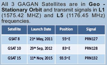
 carrying GAGAN payloads are already operational.")

12 GAGAN (GPS Aided Geo Augmented Navigation) ISRO-AAI Two Satellites GSAT-8 (PRN127) & GSAT-10 (PRN128) carrying GAGAN payloads are already operational. GAGAN Payload (PRN132) onboard GSAT-15 serves as the on-orbit spare. GAGAN is the first SBAS system in the world to have the capability of vertical guidance in the Equatorial Anomaly Regions, i.e. India

13 GAGAN SPACE SEGMENT

 - Established at Bengaluru")

14 GAGAN GROUND SEGMENT 15 INRES (Indian Reference Stations) - Each having pair of receivers 2 INMCC (Indian Master Control Centre) - Located at Bengaluru 3 INLUS (Indian Navigation Land Uplink Station) - Established at Bengaluru ; Redundant INLUS at Delhi Communication links between INRES & INMCC - Highly reliable optical fiber links have been established


15 GAGAN FOR CIVIL AVIATION GAGAN operations are fully certified for en-route Navigation (RNP 0.1) in Indian Flight Information Region (FIR) since Dec 30, 2013 GAGAN operation are also certified for Precision Approach with Vertical guidance APV 1 since April 21, 2015
16 En-Route - RNP 0.1 Service GAGAN PERFORMANCE Parameter Requirement Measured Performance Availability > 99% over Indian FIR > 99% Horizontal Accuracy < 72m 95% bound 0.7m Vertical Accuracy NA 1.5m Avg Precision Approch - APV 1.0 Service Parameter Requirement Measured Performance Availability Horizontal Accuracy > 99% over 76% of India < 7.6 m 95% bound ~ 3.0m Vertical Accuracy < 7.6 m 95% bound ~ 4.0m > 99% over 86.57% of India


")


17 NavIC and GAGAN RECEIVERS Features 36 Hardware Channels (11 L S + 12 GPS + 2 GAGAN) NavIC and Hybrid Modes Simultaneous Position Solutions NavIC Text Messages Display NMEA v2.30 supported Hardware Fabricated by Industry NAVIC Antenna


18 NavIC and GAGAN : FUTURE ACTIONS ISRO is in liaison with different National agencies for the adoption of IRNSS & GAGAN receivers. India is actively engaged in dialogue with other GNSS operators in establishing the compatibility. India continues to work with international forum like ICG, ITU RES-609 for addressing compatibility and interoperability matters.


19 THANK YOU The future depends on what we do in the present. - Mahatma Gandhi
GAGAN implementation and certification Programme. Presented by India
 GAGAN implementation and certification Programme Presented by India GPS Aided Geo Augmented Navigation International Civil Aviation Organization (ICAO) Member States Endorsed Global Satellite Navigation
GAGAN-Extension to the Gulf Region. Joint ACAC/ICAO MID Workshop on GNSS 7 th & 8 th November 2017
 GAGAN-Extension to the Gulf Region Joint ACAC/ICAO MID Workshop on GNSS 7 th & 8 th November 2017 P.N.S. KUSHWAHA EXECUTIVE DIRECTOR (CNS P) Airports Authority of India New Delhi Topics covered : 1. GAGAN
The Indian Regional Navigation. First Position Fix with IRNSS. Successful Proof-of-Concept Demonstration
 Successful Proof-of-Concept Demonstration First Position Fix with IRNSS A. S. GANESHAN, S. C. RATNAKARA, NIRMALA SRINIVASAN, BABU RAJARAM, NEETHA TIRMAL, KARTIK ANBALAGAN INDIAN SPACE RESEARCH ORGANISATION
GAGAN Initiatives Jan 18, 2018
 GAGAN Initiatives Jan 18, 2018 Topics covered 1. Brief profile of GAGAN 2. Features / Accuracy of GAGAN System 3. GAGAN Architecture 4. GAGAN services and Coverage 5. GAGAN utilization in aviation sector
Indian Regional Navigation Satellite System (IRNSS)
") Indian Regional Navigation Satellite System (IRNSS) Presentation By Mr. K.N.Suryanarayana Rao Project Director, IRNSS ISRO Satellite Centre, Airport Road, Bangalore. IRNSS IRNSS Refers to Indian Regional
Indian Regional Navigation Satellite System (IRNSS) Presentation By Mr. K.N.Suryanarayana Rao Project Director, IRNSS ISRO Satellite Centre, Airport Road, Bangalore. IRNSS IRNSS Refers to Indian Regional
Global Navigation Satellite System and Augmentation
 Global Navigation Satellite System and Augmentation KCTSwamy Knowing about Global Navigation Satellite System (GNSS) is imperative for engineers, scientists as well as civilians because of its wide range
INDIAN REGIONAL NAVIGATION SATELLITE SYSTEM
 INDIAN REGIONAL NAVIGATION SATELLITE SYSTEM R. Shriwas 1, R. Bele 2, R. kalaskar 3, P. Jaiwsal 4 Prof. Ravi S. Shriwas- ravi.shriwas@gmail.com Ms. Rupali D.Bele - rupalibele02@gmail.com Ms.Rhutuja R. Kalaskar-
Indian Regional Navigation Satellite System
 Indian Regional Navigation Satellite System Parimal Majithiya, Kriti Khatri, J. K. Hota Space Applications CentRE, Indian Space Research Organization (ISRO) Correction Parameters for Timing Group Delays
Dr. Mahesh Sharma Minister of State, Civil Aviation
 The First GNSS NEWS LETTER Jointly produced by ISRO and AAI To mark the Dedication of GAGAN to Aviation Shri P. Ashok Gajapathi Raju Minister of Civil Aviation Dr. Mahesh Sharma Minister of State, Civil
Indian GNSS Paradigm A.S.GANESHAN. Program Director - SATNAV ISAC/ISRO, Bangalore. SCPNT Nov.2015 STANFORD PALOALTO 1
 Indian GNSS Paradigm Dr. S. PAL [FIEEE, FNAE, FNASc, Dist. Fellow IETE, IET(UK), MIAA(Paris)] Vice Chancellor Defence Ins6tute of Advanced Technology, (Deemed University), Girinagar, Pune 411025 (Former
SBAS solution GCC, Yemen and Iraq System baseline and performance
 SBAS solution GCC, Yemen and Iraq System baseline and performance ACAC Workshop Rabat 7 & 8 November 2017 1 2017 Thales Alenia Space PROPRIETARY C O M MINFORMATION E R C I A L I N THALES C O ALENIA N F
Initial Results of IRNSS Standalone and Hybrid Operations
 Initial Results of IRNSS Standalone and Hybrid Operations Anindya Bose Sujoy Mandal, Kousik Samanta, (Ms) Debipriya Dutta, Suvro Kundu, Atanu Santra Department of Physics, The University of Burdwan, India
Lecture-1 CHAPTER 2 INTRODUCTION TO GPS
 Lecture-1 CHAPTER 2 INTRODUCTION TO GPS 2.1 History of GPS GPS is a global navigation satellite system (GNSS). It is the commonly used acronym of NAVSTAR (NAVigation System with Time And Ranging) GPS (Global
Challenges and Solutions for GPS Receiver Test
 Challenges and Solutions for GPS Receiver Test Presenter: Mirin Lew January 28, 2010 Agenda GPS technology concepts GPS and GNSS overview Assisted GPS (A-GPS) Basic tests required for GPS receiver verification
Indian GNSS Industry Overview Challenges and future prospects
 Indian GNSS Industry Overview Challenges and future prospects Expert Presentation By Dr. S.V. Kibe Consultant, SATCOM & GNSS, Bangalore, India (Former Programme Director, SATNAV,ISRO HQ) On February 20,2013
Modeling of IRNSS System Time-Offset with Respect to other GNSS
 Modeling of IRNSS System Time-Offset with Respect to other GNSS Kalasagar Varma* D.Rajarajan Neetha Tirmal Rathnakara S C Ganeshan A S Space navigation group, ISRO satellite centre, Bangalore 560017, India
GPS/WAAS Program Update
 GPS/WAAS Program Update UN/Argentina Workshop on the Applications of GNSS 19-23 March 2018 Cordoba, Argentina GNSS: A Global Navigation Satellite System of Systems Global Constellations GPS (24+3) GLONASS
The EU Satellite Navigation programmes status Applications for the CAP
 The EU Satellite Navigation programmes status Applications for the CAP Michaël MASTIER European Commission DG ENTR GP3 GNSS Applications, Security and International aspects GPS Workshop 2010 Montpellier
Aviation Benefits of GNSS Augmentation
 Aviation Benefits of GNSS Augmentation Workshop on the Applications of GNSS Chisinau, Moldova 17-21 May 2010 Jeffrey Auerbach Advisor on GNSS Affairs Office of Space and Advanced Technology U.S. Department
Keynote Address. Title: Space Transportation system Design- A System Engineering Approach
 Keynote Address Title: Space Transportation system Design- A System Engineering Approach Speaker- Dr. M. V. Dhekane Former Director, ISRO, Thiruvananthapuram, India Space Transportation system development
Acquisition and Tracking of IRNSS Receiver on MATLAB and Xilinx
 Acquisition and Tracking of IRNSS Receiver on MATLAB and Xilinx Kishan Y. Rathod 1, Dr. Rajendra D. Patel 2, Amit Chorasiya 3 1 M.E Student / Marwadi Education Foundation s Groups of Institute 2 Accociat
Report of the Working Group B: Enhancement of Global Navigation Satellite Systems (GNSS) Services Performance
 Services Performance") Report of the Working Group B: Enhancement of Global Navigation Satellite Systems (GNSS) Services Performance 1. The Working Group on Enhancement of Global Navigation Satellite Systems (GNSS) Service Performance
Report of the Working Group B: Enhancement of Global Navigation Satellite Systems (GNSS) Services Performance 1. The Working Group on Enhancement of Global Navigation Satellite Systems (GNSS) Service Performance
GNSS Programme. Overview and Status in Europe
 GNSS Programme Overview and Status in Europe Inaugural Forum Satellite Positioning Research and Application Center 23 April 2007 Tokyo Presented by Thomas Naecke (European Commission) Prepared by Daniel
Global Positioning Systems Directorate
 Space and Missile Systems Center Global Positioning Systems Directorate GPS Program Update to 8 th Stanford PNT Symposium 30 Oct 2014 Col Matt Smitham Deputy Director, GPS Directorate Global Positioning
INTERNATIONAL CIVIL AVIATION ORGANIZATION
 INTERNATIONAL CIVIL AVIATION ORGANIZATION AFI PLANNING AND IMPLEMENTATION REGIONAL GROUP EIGHTEENTH MEETING (APIRG/18) Kampala, Uganda (27 30 March 2012) Agenda Item 3: Performance Framework for Regional
Current status of Quasi-Zenith Satellite System. Japan Aerospace Exploration Agency QZSS Project Team
 Current status of Quasi-Zenith Satellite System Japan Aerospace Exploration Agency QZSS Project Team 1 Quasi-Zenith Satellite System The QZSS is a regional space-based PNT (Positioning, Navigation and
Report of Working Group B: Enhancement of Global Navigation Satellite Systems Services Performance
 Report of : Enhancement of Global Navigation Satellite Systems Services Performance 1. The Working Group on Enhancement of Global Navigation Satellite Systems (GNSS) Service Performance (WG-B) of the International
A Survey on SQM for Sat-Nav Systems
 A Survey on SQM for Sat-Nav Systems Sudarshan Bharadwaj DS Department of ECE, Cambridge Institute of Technology, Bangalore Abstract: Reduction of multipath effects on the satellite signals can be accomplished
International Journal of ISSN Systems and Technologies Vol.3, No.1, pp IJST KLEF 2010
 International Journal of ISSN 0974-2107 Systems and Technologies Vol.3, No.1, pp 127-137 IJST KLEF 2010 Use of Two-Way CDMA Ranging for Precise Orbit Determination of IRNSS Satellites T.Subramanya Ganesh
Galileo & EGNOS Programmes Status
 Galileo & EGNOS Programmes Status Ugo Celestino, European Commission EURO-MEDITERRANEAN TRANSPORT FORUM GNSS WORKING GROUP 16 th October 2012 17 October, 2012 The European GNSS Programmes 2 Table of contents
System Status and Performance Improvement Prospects
 Communication Геодезия Navigation GLOBAL NAVIGATION SATELLITE SYSTEM (GLONASS): System Status and Performance Improvement Prospects Viktor KOSENKO, First Deputy General Designer First Deputy General Director
Nigerian Communications Satellite Ltd. (NIGCOMSAT)
") OVERVIEW OF NIGERIAN SATELLITE AUGMENTATION SYSTEM COMMENCING WITH PILOT DEMONSTRATION TO VALIDATE NATIONAL WORK PLAN presented by Dr. Lawal Lasisi Salami, NIGERIAN COMMUNICATIONS SATELLITE LTD UNDER FEDERAL
OVERVIEW OF NIGERIAN SATELLITE AUGMENTATION SYSTEM COMMENCING WITH PILOT DEMONSTRATION TO VALIDATE NATIONAL WORK PLAN presented by Dr. Lawal Lasisi Salami, NIGERIAN COMMUNICATIONS SATELLITE LTD UNDER FEDERAL
GPS Civil Service Update & U.S. International GNSS Activities
 GPS Civil Service Update & U.S. International GNSS Activities International GNSS (IGNSS) Conference Sydney, Australia Jeffrey Auerbach Office of Space and Advanced Technology U.S. Department of State 06
European Geostationary Navigation Overlay Service (EGNOS) Capability on Sirius 5 Satellite for SES
 Capability on Sirius 5 Satellite for SES") 21 October 2009 SES SIRIUS European Geostationary Navigation Overlay Service (EGNOS) Capability on Sirius 5 Satellite for SES Mike Pavloff, Executive Director, Space Systems/Loral Information included
21 October 2009 SES SIRIUS European Geostationary Navigation Overlay Service (EGNOS) Capability on Sirius 5 Satellite for SES Mike Pavloff, Executive Director, Space Systems/Loral Information included
GLONASS Status and Modernization
 GLONASS Status and Modernization Ekaterina Oleynik Central Research Institute of Roscosmos Federal Space Agency United Nations/Latvia Workshop on the Applications of Global Navigation Satellite Systems
Significance of instrumental biases and dilution of precision in the context of GAGAN
 Indian Journal of Radio & Space Physics Vol. 36, October 2007, pp. 405-410 Significance of instrumental biases and dilution of precision in the context of GAGAN Quddusa Sultana 1, Dhiraj Sunehra, D Venkata
Storms in Earth s ionosphere
 Storms in Earth s ionosphere Archana Bhattacharyya Indian Institute of Geomagnetism IISF 2017, WSE Conclave; Anna University, Chennai Earth s Ionosphere Ionosphere is the region of the atmosphere in which
Galileo. 7th ITFS, Rome, Italy, 3-5 November Dr. Stefan Bedrich. Kayser-Threde GmbH Wolfratshauser Str Munich
 Kayser-Threde GmbH Wolfratshauser Str. 48 81379 Munich spacetech@kayser-threde.com Galileo 7th ITFS, Rome, Italy, 3-5 November 2009 Dr. Stefan Bedrich w w w. k a y s e r - t h r e d e. c o m Outline Motivation
Principal Investigator Co-Principal Investigator Co-Principal Investigator Prof. Talat Ahmad Vice-Chancellor Jamia Millia Islamia Delhi
 Subject Paper No and Title Module No and Title Module Tag Geology Remote Sensing and GIS Concepts of Global Navigation Satellite RS & GIS XXXIII Principal Investigator Co-Principal Investigator Co-Principal
Basics of Satellite Navigation an Elementary Introduction Prof. Dr. Bernhard Hofmann-Wellenhof Graz, University of Technology, Austria
 Basics of Satellite Navigation an Elementary Introduction Prof. Dr. Bernhard Hofmann-Wellenhof Graz, University of Technology, Austria CONCEPT OF GPS Prof. Dr. Bernhard Hofmann-Wellenhof Graz, University
Current Status of the Japanese Quasi-Zenith Satellite System (QZSS)
") Current Status of the Japanese Quasi-Zenith Satellite System (QZSS) 12 November 2008 Koji TERADA QZSS Project Manager Japan Aerospace Exploration Agency Contents Introduction Concept of the QZSS System
Current Status of the Japanese Quasi-Zenith Satellite System (QZSS) 12 November 2008 Koji TERADA QZSS Project Manager Japan Aerospace Exploration Agency Contents Introduction Concept of the QZSS System
SPS Gold Code Generation and Implementation for IRNSS User Receiver
 RESEARCH ARTICLE OPEN ACCESS SPS Gold Code Generation and Implementation for IRNSS User Receiver Shachi Varku 1, Swetha A 2, Sharanya S Konandur 3, Dileep D 4, Aklpita L Kulkarni 5 1,2,3,5 (Department
Global Navigation Satellite System (GLONASS): Status and Development
: Status and Development") Global Navigation Satellite System (GLONASS): Status and Development Tatiana Mirgorodskaya Information and Analysis Center for Positioning, Navigation and Timing Roscosmos State Corporation UN-Nepal Workshop
Global Navigation Satellite System (GLONASS): Status and Development Tatiana Mirgorodskaya Information and Analysis Center for Positioning, Navigation and Timing Roscosmos State Corporation UN-Nepal Workshop
Report on a Multi-GNSS Demonstration project in the Asia/Oceania region
 Report on a Multi-GNSS Demonstration project in the Asia/Oceania region - Asia Oceania is the Showcase of New GNSS Era - Japan Aerospace Exploration Agency ICG 5@Turin, Italy October 19, 2010 1 Back Ground
Update on GNSS Time Creation and Distribution - How well does it really work?
 Update on GNSS Time Creation and Distribution - How well does it really work? ITSF November 1, 2016 Prague Marc A. Weiss, Ph.D. Consultant for National Institute of Standards and Technology marcweissconsulting@gmail.com
The Galileo and EGNOS Programmes
 The Galileo and EGNOS Programmes Dominic Hayes European Commission ignss, Gold Coast, 14 July 2015 The European GNSS Programmes 2 Organisation and Contractual Frameworks European Union Member States (28)
GPS/GNSS What is it? How Does it Work? What are its Applications?
 GPS/GNSS What is it? How Does it Work? What are its Applications? Historic Navigation Reference points in the sky used for navigation The Sun The Pole Star / North Star Southern Cross Gives Direction,
REPORT OF COMMITTEE B TO THE CONFERENCE ON AGENDA ITEM 6
 1/10/03 ELEVENTH AIR NAVIGATION CONFERENCE Montreal, 22 September to 3 October 2003 REPORT OF COMMITTEE B TO THE CONFERENCE ON AGENDA ITEM 6 The attached report has been approved by Committee B for submission
Tracking and Analysis of IRNSS Satellites by Using IRNSS Receiver in STK Simulation
 Int. Conf. on Signal, Image Processing Communication & Automation, ICSIPCA Tracking and Analysis of IRNSS Satellites by Using IRNSS Receiver in STK Simulation Raghu N 1, Raghavendra Kumar M 2, Shubhanka
GLONASS PROGRAMME UPDATE
 GLONASS PROGRAMME UPDATE Ivan Revnivykh Roscosmos State Space Corporation 11 th Meeting of the International Committee on Global Navigation Satellite System November 7, 2016 Sochi, Russian Federation CONTENTS
BeiDou: Bring the World and China to Your Doorstep
 IGS Workshop 2012-ICG Working Group A BeiDou: Bring the World and China to Your Doorstep China Satellite Navigation Office 2012.7.25 Olsztyn, Poland 1 Contents I. Development Schemes II. Performance III.
Satellite-Based Augmentation System (SBAS) Integrity Services
 Integrity Services") Satellite-Based Augmentation System (SBAS) Integrity Services Presented To: Munich, Germany Date: March 8, 2010 By: Leo Eldredge, Manager GNSS Group, FAA FAA Satellite Navigation Program 2 Wide Area Augmentation
Satellite-Based Augmentation System (SBAS) Integrity Services Presented To: Munich, Germany Date: March 8, 2010 By: Leo Eldredge, Manager GNSS Group, FAA FAA Satellite Navigation Program 2 Wide Area Augmentation
In satellite navigation, the user receiver
 Measuring Navigation Payload Absolute in Radiation Mode Satellite navigation signals transmitted on different carrier frequencies are imperfectly synchronized due to different hardware paths corresponding
RAPID DEVELOPMENT OF NAVIGATION PAYLOADS FOR GALILEO FULL OPERATIONAL CAPABILITY
 Changing the economics of space RAPID DEVELOPMENT OF NAVIGATION PAYLOADS FOR GALILEO FULL OPERATIONAL CAPABILITY Alex da Silva Curiel Dubai, January 2011 SSTL - the company UK-based satellite manufacturing
Dimov Stojče Ilčev. CNS Systems
 Stratospheric Platform Systems (SPS) Presentation by: Dimov Stojče Ilčev Durban University of Technology (DUT) Space Science Centre (SSC) CNS Systems August 2011 SPS for Mobile CNS Applications Stratospheric
GBAS FOR ATCO. June 2017
 GBAS FOR ATCO June 2017 Disclaimer This presentation is for information purposes only. It should not be relied on as the sole source of information, and should always be used in the context of other authoritative
ICG GNSS Interoperability Workshop A Civil Aviation Perspective
 Approved for Public Release; Distribution Unlimited. 13-1907. ICG GNSS Interoperability Workshop A Civil Aviation Perspective C h r i s t o p h e r J. H e g a r t y A p r i l 2 0 1 3 Disclaimer: The contents
GLObal Navigation Satellite System (GLONASS)
") FEDERAL SPACE AGENCY GLObal Navigation Satellite System (GLONASS) Sergey Revnivykh Deputy Director General Central Research Institute of Machine Building Head of PNT Center 4-th meeting of International
FEDERAL SPACE AGENCY GLObal Navigation Satellite System (GLONASS) Sergey Revnivykh Deputy Director General Central Research Institute of Machine Building Head of PNT Center 4-th meeting of International
Performance Evaluation of Differential Global Navigation Satellite System with RTK Corrections
 IOSR Journal of Electronics and Communication Engineering (IOSR-JECE) e-issn: 2278-2834,p- ISSN: 2278-8735.Volume 9, Issue 2, Ver. VI (Mar - Apr. 2014), PP 43-47 Performance Evaluation of Differential
GNSS: CNS Dependencies
 GNSS: CNS Dependencies Lendina Smaja DATM/RDS/NAV 10 March 2015 Agenda The Future Technical Environment GNSS GNSS Supporting CNS Loss of Signal Impact GNSS: CNS Dependencies 2 Original FANS CNS/ATM Concept
Radio Navigation Aids Flight Test Seminar
 Radio Navigation Aids Flight Test Seminar FLIGHT INSPECTION IN THE NEW MILLENNIUM Curt Keedy FAA Flight Inspection Policy and Standards Change, Challenge, and Opportunity CHANGES Global Positioning system
Technical Specifications Document. for. Satellite-Based Augmentation System (SBAS) Testbed
 Testbed") Technical Specifications Document for Satellite-Based Augmentation System (SBAS) Testbed Revision 3 13 June 2017 Table of Contents Acronym Definitions... 3 1. Introduction... 4 2. SBAS Testbed Realisation...
Technical Specifications Document for Satellite-Based Augmentation System (SBAS) Testbed Revision 3 13 June 2017 Table of Contents Acronym Definitions... 3 1. Introduction... 4 2. SBAS Testbed Realisation...
SDCM present status and future. GLONASS signals development.
 The Eighth Meeting of the International Committee on Global Navigation Satellite Systems, November 9 14, 2013, Dubai SDCM present status and future. GLONASS signals development. Prof. Grigory Stupak, Dr.
HORIZONTAL ARAIM AVAILABILITY FOR CIVIL AVIATION OPERATIONS. ARAIM Outreach event
 HORIZONTAL ARAIM AVAILABILITY FOR CIVIL AVIATION OPERATIONS ARAIM Outreach event Moses1978 copyright April 7, 2017 H-ARAIM availability for civil aviation operations 07/04/2017 1 INTRODUCTION Space Segment
Development of BeiDou Navigation Satellite System
 The 8 th Meeting of the International Committee on GNSS Development of BeiDou Navigation Satellite System China Satellite Navigation Office Dubai, UAE November, 2013 Contents Contents 1. Objectives and
RESEARCH AND TRAINING UNIT FOR NAVIGATIONAL ELECTRONICS OSMANIA UNIVERSITY, HYDERABAD
 4-Day Short Course on Scientists, Engineers and academicians working in the area of GNSS for more than a decade in the Industry, R&D Labs and Academic Institutes, will deliver the lectures. Technologies
ICG WG-B Achievements on Interoperable GNSS Space Service Volume (SSV) November, 2016 Sochi, Russian Federation
 November, 2016 Sochi, Russian Federation") ICG WG-B Achievements on Interoperable GNSS Space Service Volume (SSV) November, 2016 Sochi, Russian Federation ICG WG-B Action Group on SSV Action group on SSV was formed within WG-B in order to Establish
ICG WG-B Achievements on Interoperable GNSS Space Service Volume (SSV) November, 2016 Sochi, Russian Federation ICG WG-B Action Group on SSV Action group on SSV was formed within WG-B in order to Establish
King AbdulAziz University. Faculty of Environmental Design. Geomatics Department. Mobile GIS GEOM 427. Lecture 3
 King AbdulAziz University Faculty of Environmental Design Geomatics Department Mobile GIS GEOM 427 Lecture 3 Ahmed Baik, Ph.D. Email: abaik@kau.edu.sa Eng. Fisal Basheeh Email: fbasaheeh@kau.edu.sa GNSS
Introduction. Global Positioning System. GPS - Intro. Space Segment. GPS - Intro. Space Segment - Contd..
 Introduction Global Positioning System Prof. D. Nagesh Kumar Dept. of Civil Engg., IISc, Bangalore 560 012, India URL: http://www.civil.iisc.ernet.in/~nagesh GPS is funded and controlled by U. S. Department
Global navigation satellite systems (GNSS) - European Galileo system
 - European Galileo system") L E C T U R E 5 Global navigation satellite systems (GNSS) - European Galileo system Lecture 5 Overview Galileo GNSS Development Architecture Principle EGNOS GNSS applications GALILEO system GALILEO system
L E C T U R E 5 Global navigation satellite systems (GNSS) - European Galileo system Lecture 5 Overview Galileo GNSS Development Architecture Principle EGNOS GNSS applications GALILEO system GALILEO system
GLONASS: Current status and perspectives
 Federal Space Agency GLONASS: Current status and perspectives 3rd ALLSAT Open conference Hannover, June 22, 2006 Vyacheslav DVORKIN, Sergey KARUTIN Russian Institute of Space Device Engineering 53, Aviamotornaya
CONSIDERATIONS FOR GNSS MEASUREMENTS
 CONSIDERATIONS FOR GNSS MEASUREMENTS Cornel PĂUNESCU 1, Cristian VASILE 2, Cosmin CIUCULESCU 3 1 PhD University of Bucharest, e-mail: cornelpaun@gmail.com 2 Lecturer PhD University of Craiova, cristi_vasile_4you@yahoo.com
SBAS DFMC performance analysis with the SBAS DFMC Service Volume software Prototype (DSVP)
") SBAS DFMC performance analysis with the SBAS DFMC Service Volume software Prototype (DSVP) D. Salos, M. Mabilleau, Egis Avia C. Rodriguez, H. Secretan, N. Suard, CNES (French Space Agency) Email: Daniel.salos@egis.fr
SBAS DFMC performance analysis with the SBAS DFMC Service Volume software Prototype (DSVP) D. Salos, M. Mabilleau, Egis Avia C. Rodriguez, H. Secretan, N. Suard, CNES (French Space Agency) Email: Daniel.salos@egis.fr
AIREON SPACE-BASED ADS-B
 AIREON SPACE-BASED ADS-B 2018 Transport Canada Delegates Conference Steve Bellingham Manager, Navigation Systems Engineering Steve.Bellingham@navcanada.ca CNS/ATM Systems Communication Navigation Surveillance
EGNOS Operations Oper and T and heir T Planned Ev E olution v
 EGNOS Operations a Th P Evo EGNOS Laurent Gauthier, Javier Ventura-Traveset, Felix Toran Navigation Department, ESA Directorate of European Union and Industrial Programmes, Toulouse, France Chantal de
RESOLUTION MSC.233(82) (adopted on 5 December 2006) ADOPTION OF THE PERFORMANCE STANDARDS FOR SHIPBORNE GALILEO RECEIVER EQUIPMENT
 (adopted on 5 December 2006) ADOPTION OF THE PERFORMANCE STANDARDS FOR SHIPBORNE GALILEO RECEIVER EQUIPMENT") MSC 82/24/Add.2 RESOLUTION MSC.233(82) THE MARITIME SAFETY COMMITTEE, RECALLING Article 28(b) of the Convention on the International Maritime Organization concerning the functions of the Committee, RECALLING
MSC 82/24/Add.2 RESOLUTION MSC.233(82) THE MARITIME SAFETY COMMITTEE, RECALLING Article 28(b) of the Convention on the International Maritime Organization concerning the functions of the Committee, RECALLING
ASSEMBLY 37TH SESSION
 International Civil Aviation Organization WORKING PAPER A37-WP/195 1 22/9/10 (Information paper) ASSEMBLY 37TH SESSION TECHNICAL COMMISSION Agenda Item 35: The Global Air Traffic Management (ATM) System
GNSS Spectrum Issues and New GPS L5
 Federal Aviation Administration Washington, D.C. GNSS Spectrum Issues and New GPS L5 International Civil Aviation Organization Regional Coordination Meeting Lima, Peru March 27 28, 2001 Basic GPS System!Space
Achievements January 2014 to January 2018
 Government of India Department of Space Indian Space Program - Highlights Achievements January 2014 to January 2018 16 February, 2018 Highlights of 4 year Achievements ISRO successfully accomplished 48
Prospect for Global Positioning Augmentation Service by QZSS
 Prospect for Global Positioning Augmentation Service by QZSS Global Positioning Augmentation Service Corporation Director, Yoshikatsu Iotake Feb. 6, 2018 Copyright 2018 Global Positioning Augmentation
Supplement to. Global navigation satellite systems (GNSS) L E C T U R E. Zuzana Bělinová. TELEMATIC SYSTEMS AND THEIR DESIGN part Systems Lecture 5
 L E C T U R E. Zuzana Bělinová. TELEMATIC SYSTEMS AND THEIR DESIGN part Systems Lecture 5") Zuzana Bělinová L E C T U R E 5 Supplement to Global navigation satellite systems (GNSS) Recapitulation Satellite navigation systems Zuzana Bělinová History of satellite navigation USA USA 1960 TRANSIT
Zuzana Bělinová L E C T U R E 5 Supplement to Global navigation satellite systems (GNSS) Recapitulation Satellite navigation systems Zuzana Bělinová History of satellite navigation USA USA 1960 TRANSIT
A TSB business Support Solution Delivered through the Technology Programme
 1 Where to now with GNSS? Peter Lancaster Technology Translator Location & Timing KTN What is the Location & Timing KTN? Knowledge Transfer Networks are funded by the UK government, through the Technology
INDIA entered into the field of COVER STORY
 COVER STORY india s space programme Source of Pride Spinning-off Myriad Benefits India surprised the world with its recent world-record feat of putting 104 satellites into different orbits in one go. But
SATELLITE BASED AUGMENTATION SYSTEM (SBAS) FOR AUSTRALIA
 FOR AUSTRALIA") SATELLITE BASED AUGMENTATION SYSTEM (SBAS) FOR AUSTRALIA AN AIN POSITION PAPER SUBMITTED TO VARIOUS GOVERNMENT DEPARTMENTS BY MR KYM OSLEY AM, CSC, EXEC SECRETARY AIN What are GNSS Augmentation Systems?
SATELLITE BASED AUGMENTATION SYSTEM (SBAS) FOR AUSTRALIA AN AIN POSITION PAPER SUBMITTED TO VARIOUS GOVERNMENT DEPARTMENTS BY MR KYM OSLEY AM, CSC, EXEC SECRETARY AIN What are GNSS Augmentation Systems?
Space Situational Awareness 2015: GPS Applications in Space
 Space Situational Awareness 2015: GPS Applications in Space James J. Miller, Deputy Director Policy & Strategic Communications Division May 13, 2015 GPS Extends the Reach of NASA Networks to Enable New
Status of ARAIM. S. Wallner ICG 6, Tokyo, Japan 05/09/2011. ESA UNCLASSIFIED For Official Use
 Status of ARAIM S. Wallner ICG 6, Tokyo, Japan 05/09/2011 ARAIM Concept Objectives Classical GPS RAIM for NPA used since years Evolving GNSS environment Multi-GNSS GPS/Galileo/Glonass/Compass/QZSS Dual-frequency
Update of BeiDou Navigation Satellite System
 Update of BeiDou Navigation Satellite System 01 03 Development Plan 02 Latest Progress Recent Plans 01 03 Development Plan 02 Development Objectives Basic Principles Development Steps Latest Progress System
One Decade of WAAS Lessons - How Would We Have Done It Differently, If Given Another Chance
 One Decade of WAAS Lessons - How Would We Have Done It Differently, If Given Another Chance Tim Schempp, WAAS Technical Director Dr. Kenneth Kung, Sr. Principal Engineering Fellow November 18, 2011 The
GALILEO Workshop, 26.Sep Marco FALCONE GALILEO System Engineering Manager GALILEO Project Office Tel
 GALILEO Workshop, 26.Sep.2005 European Space Agency A g ence spatiale européenne ESTEC Postbus 299 - NL2200 AG Noordwijk - Keplerlaan - NL 2201 AZ Noordwijk ZH - Tel. (31) 71 5656565 - Fax (31) 71 5656040
New Thrust in Indian Space Programme
 New Thrust in Indian Space Programme A Glance Dr. M Annadurai Director, ISRO Satellite Centre International Technical Meet on Quality Assurance Jan 2018 Vision: Harness space technology for national development
Wide Area Augmentation System (WAAS)
") Wide Area Augmentation System (WAAS) Ionospheric Effects Symposium By: Jason Burns Technology Evolution Lead Date: Agenda WAAS Overview Ionospheric Effects on WAAS Future Plans User Segment Update 2 WAAS
Wide Area Augmentation System (WAAS) Ionospheric Effects Symposium By: Jason Burns Technology Evolution Lead Date: Agenda WAAS Overview Ionospheric Effects on WAAS Future Plans User Segment Update 2 WAAS
The Wide Area Augmentation System
 The Wide Area Augmentation System Stanford University http://waas.stanford.edu What is Augmentation? 2 Add to GNSS to Enhance Service Improve integrity via real time monitoring Improve availability and
Update on BeiDou Navigation Satellite System
 Update on BeiDou Navigation Satellite System 1 BDS Development 2 Near-term Plans BD-2 System FOC services from December, 2012 (5GEO+5IGSO+4MEO) Two on-orbit backup satellites launched in 2016 (1 IGSO+1
GPS Status and Modernization
 GPS Status and Modernization Nov 2011 Colonel Harold Martin PNT Command Lead AFSPC A3P "This briefing is for information only. No US Government commitment to sell, loan, lease, co-develop or co-produce
ICAO policy on GNSS, GNSS SARPs and global GNSS developments. Jim Nagle Chief, Communication, Navigation and Surveillance Section ICAO
 ICAO policy on GNSS, GNSS SARPs and global GNSS developments Jim Nagle Chief, Communication, Navigation and Surveillance Section ICAO Presentation overview Introduction GNSS developments in ICAO ICAO policy
Understanding GPS/GNSS
 Understanding GPS/GNSS Principles and Applications Third Edition Contents Preface to the Third Edition Third Edition Acknowledgments xix xxi CHAPTER 1 Introduction 1 1.1 Introduction 1 1.2 GNSS Overview
Prototyping Advanced RAIM for Vertical Guidance
 Prototyping Advanced RAIM for Vertical Guidance Juan Blanch, Myung Jun Choi, Todd Walter, Per Enge. Stanford University Kazushi Suzuki. NEC Corporation Abstract In the next decade, the GNSS environment
Introduction to Global Navigation Satellite System (GNSS) Module: 1
 Module: 1") Introduction to Global Navigation Satellite System (GNSS) Module: 1 Dinesh Manandhar Center for Spatial Information Science The University of Tokyo Contact Information: dinesh@iis.u-tokyo.ac.jp Slide :
Introduction to Global Navigation Satellite System (GNSS) Module: 1 Dinesh Manandhar Center for Spatial Information Science The University of Tokyo Contact Information: dinesh@iis.u-tokyo.ac.jp Slide :
DRONACHARYA GROUP OF INSTITUTIONS, GREATER NOIDA. SATELLITE COMMUNICATIONS (EEC 021) QUESTION BANK
 QUESTION BANK") DRONACHARYA GROUP OF INSTITUTIONS, GREATER NOIDA. SATELLITE COMMUNICATIONS (EEC 021) QUESTION BANK 1. Write the advantages and disadvantages of Satellite Communication. 2. Distinguish between active and
DRONACHARYA GROUP OF INSTITUTIONS, GREATER NOIDA. SATELLITE COMMUNICATIONS (EEC 021) QUESTION BANK 1. Write the advantages and disadvantages of Satellite Communication. 2. Distinguish between active and
Resection. We can measure direction in the real world! Lecture 10: Position Determination. Resection Example: Isola, Slovenia. Professor Keith Clarke
 Geography 12: Maps and Spatial Reasoning Lecture 10: Position Determination We can measure direction in the real world! Professor Keith Clarke Resection Resection Example: Isola, Slovenia Back azimuth