Risk Mitigation in the Ground Mission Segment using the Galileo System Test Bed
|
|
|
- Joy Hutchinson
- 6 years ago
- Views:
Transcription


1 Risk Mitigation in the Ground Mission Segment using the Galileo System Test Bed 10 Years IGS 4 March 2004, Bern Marco.Falcone@esa.int Manfred.Lugert@esa.int
2 Service Performance GALILEO Global Services Open Service Commercial Services Safety of Life Services Coverage Global Global Global Positioning Accuracy 15 m H - 35 m V (single frequency) 4 m H - 8 m V (dual frequency) 4 m H - 8 m V (dual frequency) Timing Accuracy 30 nsec 30 nsec Availability 99.5% 99.5% 99.5% Integrity None None Required Alert Limit 12 m H - 20 m V Time to Alert 6 seconds Integrity Risk 3.5 x 10⁻⁷ / 150 seconds Continuity Risk 1.0 x 10⁻⁵ / 15 seconds Access Control Certification and Service Guarantees Free Open Access None Controlled Access of Ranging Code and Nav Data Message Guarantee of Service Possible Controlled Access of Nav Data Message Build for Certification and Guarantee of Service
3 Ground Segment Concept Space Segment GCS Galileo Control System S-Band C-Band L-Band GMS GCC TT&C Galileo Mission System Galileo Control Center Telemetry, Tracking and Command Station GCS TT&C ULS GSS GMS Mission Management Office GSS ULS Galileo Sensor Station (Mission Data) Uplink Station 10 Sites 5 Sites 29 Sites SAR Return Link Service Provider Leased Satellite Control Facilities Sat/Payload manufacturers GCC 2 Centers Satellite Laser Ranging External Regional Integrity Systems Service Centres Geodetic Reference Providers Time Reference Provider
4 G/S Main Components The Galileo Ground Segment comprises the Ground Control Segment (GCS) and the Ground Mission Segment (GMS) and includes: Global network of Galileo Sensor Stations (GSS) Global network of Up-link Stations (ULS) for real-time mission data up-link in C-Band Global network of Telemetry, Telecommand and Ranging Stations (TT&C) for control of the satellites in S-Band Interconnecting high performance communication network and 2 geographically redundant Galileo Control Centres (GCC) for all the centralised processing, monitoring & control.
5 Risk Mitigation
6 Ground Mission Segment Risks Analysis Consolidation of Navigation performance and associated processing algorithms Consolidation of Integrity performance regarding the establishment of SISA and SISMA confidence levels, and the associated characterisation of Feared Events Consolidation of GSS Receiver Output Quality (i.e. multipath, interference and receiver noise) for the different Galileo Signal In Space frequencies Tuning of performances taking into account space segment characteristics (e.g. On-board clocks, MEO environment, Inter Frequency Bias, etc)

 Galileo Full Operation Const.")
7 Risk Mitigation: Incremental development logic GPS and GLONASS Constellations Galileo Exp. SV (*1) Galileo In Orbit Validation Const. (*4) Galileo Full Operation Const. (30) G S T B V 1 G S T B V 2 IO V Phase FO C Phase
8 GSTB-V1
9 Galileo System Test Bed V1 Objectives GSTB V1 reduces the risk on the Galileo ground segment development through early experimentation with the Orbit Determination & Time Synchronisation and Integrity algorithms. Processing Facilities pre-developments are conducted based on realistic measurements from the GPS system Collaboration with the International GPS Service community and UTC Time Community established
10

11 GSTB-V1 Sensor Stations Network
12 GSTB-V1 Experimentation

13 Areas of Experimentation
14 ODTS & SISA Performance Targets GMS REQUIREMENTS E-OSPF Experimentation Target Test Constraints Predicted Clocks Predicted Orbits GMSREQ cm Ranging Accuracy (67% percentile) 1.5 2ns (6 h prediction time, 67% percentile) 20 cm (6 h prediction time, 67% percentile) GPS Block IIR clocks Restituted Clocks Restituted Orbits GMSREQ ,3 ns (67% percentile) GMSREQ cm (67% percentile) Target: 0,3ns (67% percentile) not yet met [~ 0.5 ns] Target: 5cm (67% percentile) not yet met [10cm] GPS Block IIR clocks SISA GMSREQ cm Target to be defined through experimentation 6 months a-priori ODTS statistics required
15 RMS range error at WUL for Block IIR satellites Comparison of the Broadcasted GPS navigation msg with the E-OSPF generated one Validity Time (2 hrs) Galileo Reqt: 65 cm
16 Integrity Performance Targets GMS REQUIREMENTS E-IPF Performance Target at ERR Test constrains Broadcast SISMA GMSREQ Nominal Broadcast SISMA lower than 70 cm. Assuming Synchro. Noise: 0.7 nsec (rms) Preprocessing range noise: 0.15 m (rms) Synchronisation noise Target: 2 nsec not yet met [~ 2.8 ns] Pre-processing Range noise Target: 1 m currently met [0.7 m] SISMA value characterised as a function of synchronisation and ranging noise (DoC unchanged) GMSREQ SISMA value not yet consolidated Synchronisation Error is at the moment the major issue to be addressed in SISMA performance


17 GPS Integrity Availability VAL 20 m VAL 35 m System unavailable PE<AL<PL System Unavailable & Misleading info AL<PE<PL Nominal operations PE<PL<AL Hazardously misleading info PE<AL<PL Misleadg. info PL<PE<AL GPS Integrity using Broadcast Navigation Message is NOT available Higher availability of GPS integrity using GSTB-V1 generated Navigation Message 1 day observations from 30 Stations Estimation of the position error based on 360 sec samples

18 GPS* SISMA map Logarithmic scale Number stations: 26 The SISMA is always above 84cm
 is 2.8 nsec. [Exp. Target = 2nsec not yet met] The Range Error is 0.7 m.")
19 GPS* Synchronization and Preprocessing Range Errors Synchronization Error Range Error The Synchronization Error (bounding standard deviation) is 2.8 nsec. [Exp. Target = 2nsec not yet met] The Range Error is 0.7 m. [Exp Target = 1m]
20 Timing Performance Targets GMS REQUIREMENTS E-PTS Performance Target at ERR Test duration constrains Prediction of the E-GST vs TAI/UTC offset Stability of E-GST vs TAI/UTC Clock Stability Measurements GMSREQ-6340 E-GST UTC < 50 ns with an uncertainty of 28 ns (95%) GMSREQ * over 1 day < 5 * GMSREQ-1377 GMSREQ-6407 AHM and Cs Clocks specification E-GST UTC < 1 µs with an uncertainty of 100 ns (95%) over 1 day up to 1 day AHM and Cs Clocks specification verification 2 months (due to BIPM data availability) 2 months (stability value to be provided accordingly) 10 days of data acquisition GSTB-V1 E-PTS E-GST vs TAI/UTC Requirements less stringent due to reuse of infrastructure and no TSP [ 1µs offset and 33 ns uncertainty] (extrapolation to 50 ns offset and 28 ns uncertainty by analysis)
21 Comparison of E-PTS E clock with USN1 The constant offset and drift have been removed The spike is due to rejected carrier phase measurements in preprocessing. The measurement include the error in the snapshot estimation of the ODTS process (around 0.2 nsec), i.e. the EPTS clock is almost the same as USN1.
22 GSTB-V1 Core Products Access
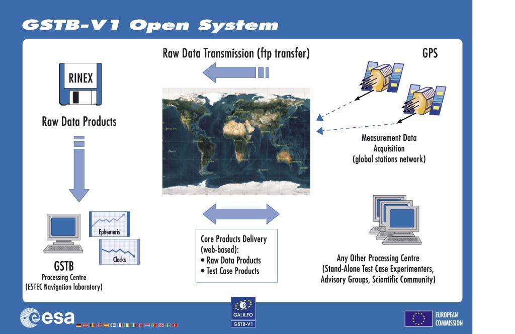
23
24 Availability of Data FTP/Web-based access: Physical Media DLT/DVD/DDS Core Products Format: Standard Format (RINEX, SP3, etc) and XML (XSLT and XSD on the web) Access to Core Products will be granted as soon as validation is completed (target: 16 March 2004)
25 GSTB-V2
26 Galileo System Test Bed V2 Objectives Secure Galileo Frequencies Test Payload technology in-orbit Provide experimental Signal-in-Space Characterize MEO radiation environment Schedule highly critical (launch date 17 October 2005) Risk Mitigation approach GSTB-V2/A Surrey Satellite Technology Ltd GSTB-V2/B Galileo Industries SA


27 GSTB-V2 / A GSTB-V2 / B

28 GSTB-V2 Architecture GSTB V2 Space Segment L-Band SIS GSTB-V2 Ground Control Segment TM/TC TTC Stations GSTB-V2 Satellite Control Centre GSTB-V2 Receiver GPS receiver GSTB-V2 Sensor Stations GSTB Processing Centre GSTB-V2 Payload Control Interface Magnetic field analysis tool Radiation analysis tool GSTB-V2 Ground Mission Segment Data collection & storage Frequency analysis tool for filing demonstration of service Signal evaluation tool Clock characterization with navigation signal International Laser Ranging ILRS stations Service Precise clock reference Precise Timing Station GALILEO Observations Simulation OSPF Prototype IPF Prototype
29 Collaboration with IGS
30 Collaboration with IGS GSTB-V1 would not exist without IGS: IGS Stations usage Reference Truth for Experimentation Collaboration with IGS needs to be continued: GSTB-V1 Experimentation Results need to be shared with the scientific community ( friendly competition ) independent assessment of critical design parameters such as CoP, CoM, BDGD, etc Establishment of RINEX format for Galileo is a priority Support in the consolidation of Galileo Navigation Message Content Integration of Galileo into IGS processing, starting with GSTB V2
GALILEO Workshop, 26.Sep Marco FALCONE GALILEO System Engineering Manager GALILEO Project Office Tel
 GALILEO Workshop, 26.Sep.2005 European Space Agency A g ence spatiale européenne ESTEC Postbus 299 - NL2200 AG Noordwijk - Keplerlaan - NL 2201 AZ Noordwijk ZH - Tel. (31) 71 5656565 - Fax (31) 71 5656040
TECHNICAL STATUS OF THE GALILEO SYSTEM DEVELOPMENT
 TECHNICAL STATUS OF THE GALILEO SYSTEM DEVELOPMENT Jörg H. Hahn Galileo Project Office, European Space Agency/ESTEC Noordwijk, The Netherlands E-mail: joerg.hahn@esa.int Abstract The development of the
Galileo. 7th ITFS, Rome, Italy, 3-5 November Dr. Stefan Bedrich. Kayser-Threde GmbH Wolfratshauser Str Munich
 Kayser-Threde GmbH Wolfratshauser Str. 48 81379 Munich spacetech@kayser-threde.com Galileo 7th ITFS, Rome, Italy, 3-5 November 2009 Dr. Stefan Bedrich w w w. k a y s e r - t h r e d e. c o m Outline Motivation
Galileo. Development Status. Navigare'09 à Neuchâtel DR. MARTIN HOLLREISER GALILEO PROJECT OFFICE - EUROPEAN SPACE AGENCY
 Galileo Development Status DR. MARTIN HOLLREISER GALILEO PROJECT OFFICE - EUROPEAN SPACE AGENCY Munich Satellite Navigation Summit 2009 Navigare'09 à Neuchâtel Programme Phases 2011-2013 4 GIOVE A/B IOV
GalileoSat System Simulation Facility (GSSF)
") GalileoSat System Simulation Facility (GSSF) VEGA Informations-Technologien GmbH Slide 1 Introduction GSSF Project Overview GSSF Requirements The GSSF System ❽ Components ❽ User Interface ❽ Technology
GalileoSat System Simulation Facility (GSSF) VEGA Informations-Technologien GmbH Slide 1 Introduction GSSF Project Overview GSSF Requirements The GSSF System ❽ Components ❽ User Interface ❽ Technology
GALILEO IOV Results. IWG Meeting 05 Feb 2014, New Delhi, India. Navigation solutions powered by Europe
 GALILEO IOV Results IWG Meeting 05 Feb 2014, New Delhi, India Navigation solutions powered by Europe IOV Mission Objectives Verification before full System Deployment: Verification of Space, Ground and
German Timing Expertise to Support Galileo
 German Timing Expertise to Support Galileo Jens Hammesfahr, Alexandre Moudrak German Aerospace Center (DLR) Institute of Communications and Navigation Muenchener Str. 20, 82234 Wessling, Germany jens.hammesfahr@dlr.de
Galileo Performance Update Rafael Lucas European Space Agency
 Galileo Performance Update Rafael Lucas European Space Agency United Nations/Argentina Workshop on the Applications of GNSS 19-23 March 2018, Falda del Carmen, Argentina ESA UNCLASSIFIED - For Official
Where Next for GNSS?
 Where Next for GNSS? Professor Terry Moore Professor of Satellite Navigation Nottingham The University of Nottingham Where Next for GNSS Back to the Future? Professor Terry Moore Professor of Satellite
GPS-Galileo Time Offset (GGTO) Galileo Implementation Status and Performance. Jörg Hahn
 Galileo Implementation Status and Performance. Jörg Hahn") GPS-Galileo Time Offset (GGTO) Galileo Implementation Status and Performance Jörg Hahn GGTO Galileo Summary Galileo-GPS Timing Offset (GGTO) as a System contribution to achieve tighter interoperability
GPS-Galileo Time Offset (GGTO) Galileo Implementation Status and Performance Jörg Hahn GGTO Galileo Summary Galileo-GPS Timing Offset (GGTO) as a System contribution to achieve tighter interoperability
GLONASS PROGRAMME UPDATE
 GLONASS PROGRAMME UPDATE Ivan Revnivykh Roscosmos State Space Corporation 11 th Meeting of the International Committee on Global Navigation Satellite System November 7, 2016 Sochi, Russian Federation CONTENTS
Precise Time Facility (PTF) for Galileo IOV
 for Galileo IOV") Von der Erde ins All. Und zurück. Intelligente Lösungen für Industrie und Wissenschaft. From Earth to Space. And back. Intelligent solutions for industry and science. E a r t h S p a c e & F u t u r e
Von der Erde ins All. Und zurück. Intelligente Lösungen für Industrie und Wissenschaft. From Earth to Space. And back. Intelligent solutions for industry and science. E a r t h S p a c e & F u t u r e
Global Navigation Satellite System (GLONASS): Status and Development
: Status and Development") Global Navigation Satellite System (GLONASS): Status and Development Tatiana Mirgorodskaya Information and Analysis Center for Positioning, Navigation and Timing Roscosmos State Corporation UN-Nepal Workshop
Global Navigation Satellite System (GLONASS): Status and Development Tatiana Mirgorodskaya Information and Analysis Center for Positioning, Navigation and Timing Roscosmos State Corporation UN-Nepal Workshop
EUROPEAN GNSS (GALILEO) INITIAL SERVICES NAVIGATION SOLUTIONS POWERED BY E U R O P E OPEN SERVICE QUARTERLY PERFORMANCE REPORT
 INITIAL SERVICES NAVIGATION SOLUTIONS POWERED BY E U R O P E OPEN SERVICE QUARTERLY PERFORMANCE REPORT") NAVIGATION SOLUTIONS POWERED BY E U R O P E EUROPEAN GNSS (GALILEO) INITIAL SERVICES OPEN SERVICE QUARTERLY PERFORMANCE REPORT JANUARY - MARCH 2018 TABLE OF CONTENTS 1 INTRODUCTION... 1 2 EXECUTIVE SUMMARY...
NAVIGATION SOLUTIONS POWERED BY E U R O P E EUROPEAN GNSS (GALILEO) INITIAL SERVICES OPEN SERVICE QUARTERLY PERFORMANCE REPORT JANUARY - MARCH 2018 TABLE OF CONTENTS 1 INTRODUCTION... 1 2 EXECUTIVE SUMMARY...
The EU Satellite Navigation programmes status Applications for the CAP
 The EU Satellite Navigation programmes status Applications for the CAP Michaël MASTIER European Commission DG ENTR GP3 GNSS Applications, Security and International aspects GPS Workshop 2010 Montpellier
Global Navigation Satellite Systems (GNSS)
") Global Navigation Satellite Systems (GNSS) Pat Norris MRAeS, FRIN LogicaCMG Business Development Manager Chairman, RAeS Space Group LogicaCMG 2006. All rights reserved 2 Global Navigation Satellite Systems
Global Navigation Satellite Systems (GNSS) Pat Norris MRAeS, FRIN LogicaCMG Business Development Manager Chairman, RAeS Space Group LogicaCMG 2006. All rights reserved 2 Global Navigation Satellite Systems
System Status and Performance Improvement Prospects
 Communication Геодезия Navigation GLOBAL NAVIGATION SATELLITE SYSTEM (GLONASS): System Status and Performance Improvement Prospects Viktor KOSENKO, First Deputy General Designer First Deputy General Director
King AbdulAziz University. Faculty of Environmental Design. Geomatics Department. Mobile GIS GEOM 427. Lecture 3
 King AbdulAziz University Faculty of Environmental Design Geomatics Department Mobile GIS GEOM 427 Lecture 3 Ahmed Baik, Ph.D. Email: abaik@kau.edu.sa Eng. Fisal Basheeh Email: fbasaheeh@kau.edu.sa GNSS
magicgnss: QUALITY DATA, ALGORITHMS AND PRODUCTS FOR THE GNSS USER COMMUNITY
 SEMANA GEOMATICA 2009 magicgnss: QUALITY DATA, ALGORITHMS AND PRODUCTS FOR THE GNSS USER COMMUNITY MARCH 3, 2009 BARCELONA, SPAIN SESSION: GNSS PRODUCTS A. Mozo P. Navarro R. Píriz D. Rodríguez March 3,
GNSS Programme. Overview and Status in Europe
 GNSS Programme Overview and Status in Europe Inaugural Forum Satellite Positioning Research and Application Center 23 April 2007 Tokyo Presented by Thomas Naecke (European Commission) Prepared by Daniel
AIV Platform for the Galileo Precise Timing Facility
 UNCLASSIFIED Nationaal Lucht- en Ruimtevaartlaboratorium National Aerospace Laboratory NLR Executive summary AIV Platform for the Galileo Precise Timing Facility Int. Comm. SNMP Phase Comparator Time Interval
ORBITS AND CLOCKS FOR GLONASS PPP
 ION GNSS 2009 ORBITS AND CLOCKS FOR GLONASS PPP SEPTEMBER 22-25, 2009 - SAVANNAH, GEORGIA SESSION E3: PPP AND NETWORK-BASED RTK 1 D. Calle A. Mozo P. Navarro R. Píriz D. Rodríguez G. Tobías September 24,
Introduction to Galileo PRS
 Introduction to Galileo PRS Fabio Covello 20/09/2017 ESA UNCLASSIFIED - For Official Use Galileo mission figures The Galileo Space Segment: 30 satellites (full constellation) Walker 24/3/1 constellation
TIME TRANSFER WITH THE GALILEO PRECISE TIMING FACILITY
 TIME TRANSFER WITH THE GALILEO PRECISE TIMING FACILITY Renzo Zanello Thales Alenia Space-Italia c. Marche 41, 10146 Torino, Italy, Tel: +390117180545 E-mail: renzo.zanello@thalesaleniaspace.com Alberto
Modelling GPS Observables for Time Transfer
 Modelling GPS Observables for Time Transfer Marek Ziebart Department of Geomatic Engineering University College London Presentation structure Overview of GPS Time frames in GPS Introduction to GPS observables
Understanding GPS: Principles and Applications Second Edition
 Understanding GPS: Principles and Applications Second Edition Elliott Kaplan and Christopher Hegarty ISBN 1-58053-894-0 Approx. 680 pages Navtech Part #1024 This thoroughly updated second edition of an
The Indian Regional Navigation. First Position Fix with IRNSS. Successful Proof-of-Concept Demonstration
 Successful Proof-of-Concept Demonstration First Position Fix with IRNSS A. S. GANESHAN, S. C. RATNAKARA, NIRMALA SRINIVASAN, BABU RAJARAM, NEETHA TIRMAL, KARTIK ANBALAGAN INDIAN SPACE RESEARCH ORGANISATION
GPS Status and Modernization
 GPS Status and Modernization Nov 2011 Colonel Harold Martin PNT Command Lead AFSPC A3P "This briefing is for information only. No US Government commitment to sell, loan, lease, co-develop or co-produce
EFTF 2012 Smartphone application for the near-real time synchronization and monitoring of clocks through a network of GNSS receivers
 EFTF 2012 Smartphone application for the near-real time synchronization and monitoring of clocks through a network of GNSS receivers APRIL 26 th, 2012 GÖTEBORG, SWEDEN SESSION C3L-B: GNSS AND APPLICATIONS
ORBITAL NAVIGATION SYSTEMS PRESENT AND FUTURE TENDS
 ORBITAL NAVIGATION SYSTEMS PRESENT AND FUTURE TENDS CONTENT WHAT IS COVERED A BRIEF HISTORY OF SYSTEMS PRESENT SYSTEMS IN USE PROBLEMS WITH SATELLITE SYSTEMS PLANNED IMPROVEMENTS CONCLUSION CONTENT WHAT
Status of the European EGNOS and Galileo Programmes. Frank Udnaes Galileo policy and Infrastructure group EC DG-TREN. June 2008
 Status of the European EGNOS and Galileo Programmes Frank Udnaes Galileo policy and Infrastructure group EC DG-TREN EUROPEAN COMMISSION z June 2008 Galileo An infrastructure 30 satellite Constellation
COMPARISON BETWEEN BROADCAST AND PRECISE ORBITS: GPS GLONASS GALILEO AND BEIDOU. A. Caporali and L. Nicolini University of Padova, Italy
 COMPARISON BETWEEN BROADCAST AND PRECISE ORBITS: GPS GLONASS GALILEO AND BEIDOU A. Caporali and L. Nicolini University of Padova, Italy Summary Previous works Input data and method used Comparison between
Galileo Integrity Concept user level
 Galileo Integrity Concept user level Presented at The Technical Universtiy of Munich Andrew Simsky, Frank Boon GPS integrity provided by SBAS (1/2) WAAS/EGNOS define Safety-Of-Life on top of GPS RTCA DO229
MICROSCOPE Mission operational concept
 MICROSCOPE Mission operational concept PY. GUIDOTTI (CNES, Microscope System Manager) January 30 th, 2013 1 Contents 1. Major points of the operational system 2. Operational loop 3. Orbit determination
PRECISE RECEIVER CLOCK OFFSET ESTIMATIONS ACCORDING TO EACH GLOBAL NAVIGATION SATELLITE SYSTEMS (GNSS) TIMESCALES
 TIMESCALES") ARTIFICIAL SATELLITES, Vol. 52, No. 4 DOI: 10.1515/arsa-2017-0009 PRECISE RECEIVER CLOCK OFFSET ESTIMATIONS ACCORDING TO EACH GLOBAL NAVIGATION SATELLITE SYSTEMS (GNSS) TIMESCALES Thayathip Thongtan National
ARTIFICIAL SATELLITES, Vol. 52, No. 4 DOI: 10.1515/arsa-2017-0009 PRECISE RECEIVER CLOCK OFFSET ESTIMATIONS ACCORDING TO EACH GLOBAL NAVIGATION SATELLITE SYSTEMS (GNSS) TIMESCALES Thayathip Thongtan National
ARAIM Fault Detection and Exclusion
 ARAIM Fault Detection and Exclusion Boris Pervan Illinois Institute of Technology Chicago, IL November 16, 2017 1 RAIM ARAIM Receiver Autonomous Integrity Monitoring (RAIM) uses redundant GNSS measurements
Understanding GPS/GNSS
 Understanding GPS/GNSS Principles and Applications Third Edition Contents Preface to the Third Edition Third Edition Acknowledgments xix xxi CHAPTER 1 Introduction 1 1.1 Introduction 1 1.2 GNSS Overview
GALILEO : Satellite System Design and Technology Developments. J. Benedicto, S.E.Dinwiddy, G. Gatti, R. Lucas, M. Lugert. European Space Agency
 GALILEO : Satellite System Design and Technology Developments J. Benedicto, S.E.Dinwiddy, G. Gatti, R. Lucas, M. Lugert European Space Agency November 2000 Abstract During 1999/2000 the GALILEO system
GNSS MONITORING NETWORKS
 SPACE GNSS MONITORING NETWORKS Satellite communications, earth observation, navigation and positioning and control stations indracompany.com GNSS MONITORING NETWORKS GNSS MONITORING NETWORKS Indra s solutions
Monitoring the EGNOS SYSTEM TEST BED at the Radio Navigation Experimentation Unit (RNEU)
") Monitoring the EGNOS SYSTEM TEST BED at the Radio Navigation Experimentation Unit (RNEU) ESTEC/ESA 2nd ESTB Workshop, Nice, 12th November 2001 What is the RNEU? Specialised facilities located at ESTEC/TOS-ET
Monitoring the EGNOS SYSTEM TEST BED at the Radio Navigation Experimentation Unit (RNEU) ESTEC/ESA 2nd ESTB Workshop, Nice, 12th November 2001 What is the RNEU? Specialised facilities located at ESTEC/TOS-ET
Real-Time and Multi-GNSS Key Projects of the International GNSS Service
 Real-Time and Multi-GNSS Key Projects of the International GNSS Service Urs Hugentobler, Chris Rizos, Mark Caissy, Georg Weber, Oliver Montenbruck, Ruth Neilan EUREF 2013 Symposium Budapest, Hungary, May
Demonstrations of Multi-Constellation Advanced RAIM for Vertical Guidance using GPS and GLONASS Signals
 Demonstrations of Multi-Constellation Advanced RAIM for Vertical Guidance using GPS and GLONASS Signals Myungjun Choi, Juan Blanch, Stanford University Dennis Akos, University of Colorado Boulder Liang
GPS and Recent Alternatives for Localisation. Dr. Thierry Peynot Australian Centre for Field Robotics The University of Sydney
 GPS and Recent Alternatives for Localisation Dr. Thierry Peynot Australian Centre for Field Robotics The University of Sydney Global Positioning System (GPS) All-weather and continuous signal system designed
EGNOS/GALILEO Status. Rafael Lucas Navigation Applications and User Services Office European Space Agency
 EGNOS/GALILEO Status Rafael Lucas Navigation Applications and User Services Office European Space Agency Rafael.Lucas.Rodriguez@esa.int European Satellite Navigation Strategy GNSS1: EGNOS Civil complement
magicgnss: Quality Data, Algorithms and Products for the GNSS User Community
 magicgnss: Quality Data, Algorithms and Products for the GNSS User Community Álvaro Mozo, GMV Ricardo Píriz, GMV Miguel M. Romay Merino, GMV Ignacio Alcantarilla, GMV BIOGRAPHY Álvaro Mozo has a Master
Integrity of Satellite Navigation in the Arctic
 Integrity of Satellite Navigation in the Arctic TODD WALTER & TYLER REID STANFORD UNIVERSITY APRIL 2018 Satellite Based Augmentation Systems (SBAS) in 2018 2 SBAS Networks in 2021? 3 What is Meant by Integrity?
Field experience with future GNSS ranging signals (a review). A.Simsky, J.-M. Sleewaegen, W. De Wilde Septentrio, Belgium
. A.Simsky, J.-M. Sleewaegen, W. De Wilde Septentrio, Belgium") Field experience with future GNSS ranging signals (a review). A.Simsky, J.-M. Sleewaegen, W. De Wilde Septentrio, Belgium Technical University of Munich June 07 2010 Contents Septentrio: company profile
Field experience with future GNSS ranging signals (a review). A.Simsky, J.-M. Sleewaegen, W. De Wilde Septentrio, Belgium Technical University of Munich June 07 2010 Contents Septentrio: company profile
Radio Navigation Aids Flight Test Seminar
 Radio Navigation Aids Flight Test Seminar FLIGHT INSPECTION IN THE NEW MILLENNIUM Curt Keedy FAA Flight Inspection Policy and Standards Change, Challenge, and Opportunity CHANGES Global Positioning system
Orion-S GPS Receiver Software Validation
 Space Flight Technology, German Space Operations Center (GSOC) Deutsches Zentrum für Luft- und Raumfahrt (DLR) e.v. O. Montenbruck Doc. No. : GTN-TST-11 Version : 1.1 Date : July 9, 23 Document Title:
Galileo Information Center for Latin America / Application of the ISMR Query Tool in the analysis of Ionospheric Scintillation from Galileo Satellites
 Galileo Information Center for Latin America / Application of the ISMR Query Tool in the analysis of Ionospheric Scintillation from Galileo Satellites Bruno César Vani Programa de Pós-graduação em Ciências
Clock Synchronization of Pseudolite Using Time Transfer Technique Based on GPS Code Measurement
 , pp.35-40 http://dx.doi.org/10.14257/ijseia.2014.8.4.04 Clock Synchronization of Pseudolite Using Time Transfer Technique Based on GPS Code Measurement Soyoung Hwang and Donghui Yu* Department of Multimedia
GALILEO COMMON VIEW: FORMAT, PROCESSING, AND TESTS WITH GIOVE
 GALILEO COMMON VIEW: FORMAT, PROCESSING, AND TESTS WITH GIOVE Pascale Defraigne Royal Observatory of Belgium (ROB) Avenue Circulaire, 3, B-1180 Brussels, Belgium e-mail: p.defraigne@oma.be M. C. Martínez-Belda
Introduction to Advanced RAIM. Juan Blanch, Stanford University July 26, 2016
 Introduction to Advanced RAIM Juan Blanch, Stanford University July 26, 2016 Satellite-based Augmentation Systems Credit: Todd Walter Receiver Autonomous Integrity Monitoring (556 m Horizontal Error Bound)
THE GPS SATELLITE AND PAYLOAD
 THE GPS SATELLITE AND PAYLOAD Andrew Codik and Robert A. Gronlund Rockwell International Corporation Satellite Systems Division 12214 Lakewood Boulevard Downey, California, USA 90241 ABSTRACT The NAVSTAR/Global
Galileo System and Signal Evolution
 Galileo System and Signal Evolution Stefan Wallner GNSS/Galileo Evolutions Programme ITSNT, 15/11/2017 HOW TO DESIGN A GNSS SYSTEM FOR THE YEAR 2040 15/11/2017 Slide 2 Navigation Exponential Evolution
Report of the Working Group B: Enhancement of Global Navigation Satellite Systems (GNSS) Services Performance
 Services Performance") Report of the Working Group B: Enhancement of Global Navigation Satellite Systems (GNSS) Services Performance 1. The Working Group on Enhancement of Global Navigation Satellite Systems (GNSS) Service Performance
Report of the Working Group B: Enhancement of Global Navigation Satellite Systems (GNSS) Services Performance 1. The Working Group on Enhancement of Global Navigation Satellite Systems (GNSS) Service Performance
MULTI-GNSS TIME TRANSFER
 MULTI-GNSS TIME TRANSFER P. DEFRAIGNE Royal Observatory of Belgium Avenue Circulaire, 3, 118-Brussels e-mail: p.defraigne@oma.be ABSTRACT. Measurements from Global Navigation Satellite Systems (GNSS) are
DESIGN OF THE PRECISE TIME FACILITY FOR GALILEO
 DESIGN OF THE PRECISE TIME FACIITY FOR GAIEO S. Bedrick 1, A. Bauch 2, A. Moudrak 3, and W. Schäfer 4 1 Kayser-Threde GmbH, Wolfratshauser Str. 48, 81379 Munich, Germany E-mail: spacetech@kayser-threde.de
GLONASS Status and Modernization
 GLONASS Status and Modernization Ekaterina Oleynik Central Research Institute of Roscosmos Federal Space Agency United Nations/Latvia Workshop on the Applications of Global Navigation Satellite Systems
Views on Interoperability
 Views on Interoperability International Committee on Global Navigation Satellite Systems Prague, November 10 th 14 th 2014 Navigation solutions powered by Europe INTRODUCTION The original purpose of the
Basics of Satellite Navigation an Elementary Introduction Prof. Dr. Bernhard Hofmann-Wellenhof Graz, University of Technology, Austria
 Basics of Satellite Navigation an Elementary Introduction Prof. Dr. Bernhard Hofmann-Wellenhof Graz, University of Technology, Austria CONCEPT OF GPS Prof. Dr. Bernhard Hofmann-Wellenhof Graz, University
Multi-GNSS / Multi-Signal code bias determination from raw GNSS observations
 Multi-GNSS / Multi-Signal code bias determination from raw GNSS observations F. Reckeweg, E. Schönemann, T. Springer, M. Becker, W. Enderle Geodätische Woche 2016 InterGEO 11.-13. October 2016 Hamburg,
Current status of Quasi-Zenith Satellite System. Japan Aerospace Exploration Agency QZSS Project Team
 Current status of Quasi-Zenith Satellite System Japan Aerospace Exploration Agency QZSS Project Team 1 Quasi-Zenith Satellite System The QZSS is a regional space-based PNT (Positioning, Navigation and
Global Positioning Systems Directorate
 Space and Missile Systems Center Global Positioning Systems Directorate GPS Program Update to 8 th Stanford PNT Symposium 30 Oct 2014 Col Matt Smitham Deputy Director, GPS Directorate Global Positioning
The Consorzio Torino Time scientific and industrial activities
 ICG-5 Torino, 18-22 October 2010 The Consorzio Torino Time scientific and industrial activities Luigi Bragagnini Consorzio Torino Time ICG-5 Torino, 20 October 2010. GNSS technology in the era of multi-systems:
Development of the Navigation Payload for the Galileo In-Orbit Validation (IOV) Phase
 Phase") International Global Navigation Satellite Systems Society IGNSS Symposium 2007 The University of New South Wales, Sydney, Australia 4 6 December, 2007 Development of the Navigation Payload for the Galileo
International Global Navigation Satellite Systems Society IGNSS Symposium 2007 The University of New South Wales, Sydney, Australia 4 6 December, 2007 Development of the Navigation Payload for the Galileo
Satellite Navigation: The European Strategy. Claudio Mastracci Director of Applications European Space Agency
 Satellite Navigation: The European Strategy Claudio Mastracci Director of Applications European Space Agency 1 EGNOS The European Approach Step 1: EGNOS is to provide civil complement to GPS over larger
ABSOLUTE CALIBRATION OF TIME RECEIVERS WITH DLR'S GPS/GALILEO HW SIMULATOR
 ABSOLUTE CALIBRATION OF TIME RECEIVERS WITH DLR'S GPS/GALILEO HW SIMULATOR S. Thölert, U. Grunert, H. Denks, and J. Furthner German Aerospace Centre (DLR), Institute of Communications and Navigation, Oberpfaffenhofen,
Principal Investigator Co-Principal Investigator Co-Principal Investigator Prof. Talat Ahmad Vice-Chancellor Jamia Millia Islamia Delhi
 Subject Paper No and Title Module No and Title Module Tag Geology Remote Sensing and GIS Concepts of Global Navigation Satellite RS & GIS XXXIII Principal Investigator Co-Principal Investigator Co-Principal
GALILEO JOINT UNDERTAKING
 GALILEO Research and development activities First call Activity A User receiver preliminary development STATEMENT OF WORK GJU/03/094/issue2/OM/ms Issue 2 094 issue2 6th FP A SOW 1 TABLE OF CONTENTS 1.
MAGICGNSS RTCM-BASED SERVICE, A LEAP FORWARD TOWARDS MULTI- GNSS HIGH ACCURACY REAL-TIME PROCESSING
 ION GNSS 2015 MAGICGNSS RTCM-BASED SERVICE, A LEAP FORWARD TOWARDS MULTI- GNSS HIGH ACCURACY REAL-TIME PROCESSING SEPTEMBER 16 TH, 2015 - ION GNSS 2015, TAMPA, FLORIDA, USA SESSION E2A: NEXT GENERATION
The Galileo and EGNOS Programmes
 The Galileo and EGNOS Programmes Dominic Hayes European Commission ignss, Gold Coast, 14 July 2015 The European GNSS Programmes 2 Organisation and Contractual Frameworks European Union Member States (28)
Sounding the Atmosphere Ground Support for GNSS Radio-Occultation Processing
 Sounding the Atmosphere Ground Support for GNSS Radio-Occultation Processing Atmospheric Sounding René Zandbergen & John M. Dow Navigation Support Office, Ground Systems Engineering Department, Directorate
Dave Podlesney Program Director Lockheed Martin Space Systems Company
 GPS III Space Segment Dave Podlesney Program Director Lockheed Martin Space Systems Company Why GPS III? Deliver critical new high-value GPS space capabilities Improved PNT accuracy and power for both
Multisystem Real Time Precise-Point-Positioning, today with GPS+GLONASS in the near future also with QZSS, Galileo, Compass, IRNSS
 2 International Symposium on /GNSS October 26-28, 2. Multisystem Real Time Precise-Point-Positioning, today with +GLONASS in the near future also with QZSS, Galileo, Compass, IRNSS Álvaro Mozo García,
Indian Regional Navigation Satellite System (IRNSS)
") Indian Regional Navigation Satellite System (IRNSS) Presentation By Mr. K.N.Suryanarayana Rao Project Director, IRNSS ISRO Satellite Centre, Airport Road, Bangalore. IRNSS IRNSS Refers to Indian Regional
Indian Regional Navigation Satellite System (IRNSS) Presentation By Mr. K.N.Suryanarayana Rao Project Director, IRNSS ISRO Satellite Centre, Airport Road, Bangalore. IRNSS IRNSS Refers to Indian Regional
Global navigation satellite systems (GNSS) - European Galileo system
 - European Galileo system") L E C T U R E 5 Global navigation satellite systems (GNSS) - European Galileo system Lecture 5 Overview Galileo GNSS Development Architecture Principle EGNOS GNSS applications GALILEO system GALILEO system
L E C T U R E 5 Global navigation satellite systems (GNSS) - European Galileo system Lecture 5 Overview Galileo GNSS Development Architecture Principle EGNOS GNSS applications GALILEO system GALILEO system
We are IntechOpen, the world s leading publisher of Open Access books Built by scientists, for scientists. International authors and editors
 We are IntechOpen, the world s leading publisher of Open Access books Built by scientists, for scientists 4,100 116,000 10M Open access books available International authors and editors Downloads Our authors
CH GPS/GLONASS/GALILEO/SBAS Signal Simulator. General specification Version 0.2 Eng. Preliminary
 CH-380 GPS/GLONASS/GALILEO/SBAS Signal Simulator General specification Version 0.2 Eng Preliminary Phone: +7 495 665 648 Fax: +7 495 665 649 navis@navis.ru NAVIS-UKRAINE Mazura str. 4 Smela, Cherkassy
TIMING ASPECTS OF GPS- GALILEO INTEROPERABILITY: CHALLENGES AND SOLUTIONS
 TIMING ASPECTS OF GPS- GALILEO INTEROPERABILITY: CHALLENGES AND SOLUTIONS A. Moudrak*, A. Konovaltsev*, J. Furthner*, J. Hammesfahr* A. Bauch**, P. Defraigne***, and S. Bedrich**** *Institute of Communications
Galileo Time Receivers
 Galileo Time Receivers by Stefan Geissler, PPM GmbH, Penzberg Germany Workshop "T&F Services with Galileo" 5/6 December 2005 Galileo Time Receivers by Stefan Geissler, PPM GmbH, Penzberg Germany Workshop
Global Navigation Satellite System (GNSS) for Disaster Mitigation
 for Disaster Mitigation") Global Navigation Satellite System (GNSS) for Disaster Mitigation By Chathura H. Wickramasinghe Geoinformatics Center Asian Institute of Technology Establish in 1959 as a Post Graduate School Catering
Global Navigation Satellite System (GNSS) for Disaster Mitigation By Chathura H. Wickramasinghe Geoinformatics Center Asian Institute of Technology Establish in 1959 as a Post Graduate School Catering
Update on BeiDou Navigation Satellite System
 Update on BeiDou Navigation Satellite System 1 BDS Development 2 Near-term Plans BD-2 System FOC services from December, 2012 (5GEO+5IGSO+4MEO) Two on-orbit backup satellites launched in 2016 (1 IGSO+1
INTEGRITY AND CONTINUITY ANALYSIS FROM GPS JULY TO SEPTEMBER 2016 QUARTERLY REPORT
 INTEGRITY AND CONTINUITY ANALYSIS FROM GPS JULY TO SEPTEMBER 2016 QUARTERLY REPORT Name Responsibility Date Signature Prepared by M Pattinson (NSL) 07/10/16 Checked by L Banfield (NSL) 07/10/16 Authorised
Alternative Positioning, Navigation and Timing (APNT) for Performance Based Navigation (PBN)
 for Performance Based Navigation (PBN)") DLR.de Chart 1 Alternative Positioning, Navigation and Timing (APNT) for Performance Based Navigation (PBN) Presented by Boubeker Belabbas Prepared by : Nicolas Schneckenburger, Elisabeth Nossek, Dmitriy
DLR.de Chart 1 Alternative Positioning, Navigation and Timing (APNT) for Performance Based Navigation (PBN) Presented by Boubeker Belabbas Prepared by : Nicolas Schneckenburger, Elisabeth Nossek, Dmitriy
Horizontal Advanced RAIM: Operational Benefits and Future Challenges
 Horizontal Advanced RAIM: Operational Benefits and Future Challenges International Technical Symposium on Navigation and Timing 2015 Session Air Navigation November 2015 Toulouse/France 1 ICAO ABAS augmentation
GLOBAL POSITIONING SYSTEM (GPS) PERFORMANCE JULY TO SEPTEMBER 2018 QUARTERLY REPORT 3
 PERFORMANCE JULY TO SEPTEMBER 2018 QUARTERLY REPORT 3") GLOBAL POSITIONING SYSTEM (GPS) PERFORMANCE JULY TO SEPTEMBER 2018 QUARTERLY REPORT 3 Name Responsibility Date Signature Prepared by M McCreadie (NSL) 24/10/2018 Checked by M Pattinson (NSL) 24/10/2018
GLOBAL POSITIONING SYSTEM (GPS) PERFORMANCE JULY TO SEPTEMBER 2018 QUARTERLY REPORT 3 Name Responsibility Date Signature Prepared by M McCreadie (NSL) 24/10/2018 Checked by M Pattinson (NSL) 24/10/2018
GALILEO Research and Development Activities. Second Call. Area 1B. Interference Detection Mitigation and Isolation.
 GALILEO Research and Development Activities Second Call Area 1B Interference Detection Mitigation and Isolation Statement of Work Rue du Luxembourg, 3 B 1000 Brussels Tel +32 2 507 80 00 Fax +32 2 507
ASSESSMENT OF THE USE OF C-BAND FOR GNSS AO 5410, closing 30/05/2007
 ASSESSMENT OF THE USE OF C-BAND FOR GNSS AO 5410, closing 30/05/2007 GNSS EVOLUTIONS PROGRAMME SYSTEM EXPLORATION STUDIES Information Day 23 rd April 2007 This presentation is for information purposes
Posicionamento por ponto com. Posicionamento por satélite UNESP PP 2017 Prof. Galera
 Posicionamento por ponto com multiconstelação GNSS Posicionamento por satélite UNESP PP 2017 Prof. Galera Single-GNSS Observation Equations Considering j = 1; : : : ; f S the frequencies of a certain GNSS
The Promise and Challenges of Accurate Low Latency GNSS for Environmental Monitoring and Response
 Technical Seminar Reference Frame in Practice, The Promise and Challenges of Accurate Low Latency GNSS for Environmental Monitoring and Response John LaBrecque Geohazards Focus Area Global Geodetic Observing
Challenges and Solutions for GPS Receiver Test
 Challenges and Solutions for GPS Receiver Test Presenter: Mirin Lew January 28, 2010 Agenda GPS technology concepts GPS and GNSS overview Assisted GPS (A-GPS) Basic tests required for GPS receiver verification
GAGAN-Extension to the Gulf Region. Joint ACAC/ICAO MID Workshop on GNSS 7 th & 8 th November 2017
 GAGAN-Extension to the Gulf Region Joint ACAC/ICAO MID Workshop on GNSS 7 th & 8 th November 2017 P.N.S. KUSHWAHA EXECUTIVE DIRECTOR (CNS P) Airports Authority of India New Delhi Topics covered : 1. GAGAN
GLOBAL POSITIONING SYSTEM (GPS) PERFORMANCE APRIL TO JUNE 2017 QUARTERLY REPORT
 PERFORMANCE APRIL TO JUNE 2017 QUARTERLY REPORT") GLOBAL POSITIONING SYSTEM (GPS) PERFORMANCE APRIL TO JUNE 2017 QUARTERLY REPORT Name Responsibility Date Signature Prepared by M Pattinson (NSL) 06/07/17 Checked by L Banfield (NSL) 06/07/17 Authorised
GLOBAL POSITIONING SYSTEM (GPS) PERFORMANCE APRIL TO JUNE 2017 QUARTERLY REPORT Name Responsibility Date Signature Prepared by M Pattinson (NSL) 06/07/17 Checked by L Banfield (NSL) 06/07/17 Authorised
GNSS: orbits, signals, and methods
 Part I GNSS: orbits, signals, and methods 1 GNSS ground and space segments Global Navigation Satellite Systems (GNSS) at the time of writing comprise four systems, two of which are fully operational and
GLOBAL POSITIONING SYSTEM (GPS) PERFORMANCE OCTOBER TO DECEMBER 2017 QUARTERLY REPORT
 PERFORMANCE OCTOBER TO DECEMBER 2017 QUARTERLY REPORT") GLOBAL POSITIONING SYSTEM (GPS) PERFORMANCE OCTOBER TO DECEMBER 2017 QUARTERLY REPORT Name Responsibility Date Signature Prepared by M Pattinson (NSL) 16/01/18 Checked by L Banfield (NSL) 16/01/18 Authorised
GLOBAL POSITIONING SYSTEM (GPS) PERFORMANCE OCTOBER TO DECEMBER 2017 QUARTERLY REPORT Name Responsibility Date Signature Prepared by M Pattinson (NSL) 16/01/18 Checked by L Banfield (NSL) 16/01/18 Authorised
GLOBAL POSITIONING SYSTEM (GPS) PERFORMANCE JANUARY TO MARCH 2017 QUARTERLY REPORT
 PERFORMANCE JANUARY TO MARCH 2017 QUARTERLY REPORT") GLOBAL POSITIONING SYSTEM (GPS) PERFORMANCE JANUARY TO MARCH 2017 QUARTERLY REPORT Name Responsibility Date Signature Prepared by M Pattinson (NSL) 11/04/17 Checked by L Banfield (NSL) 11/04/17 Authorised
GLOBAL POSITIONING SYSTEM (GPS) PERFORMANCE JANUARY TO MARCH 2017 QUARTERLY REPORT Name Responsibility Date Signature Prepared by M Pattinson (NSL) 11/04/17 Checked by L Banfield (NSL) 11/04/17 Authorised
GLOBAL POSITIONING SYSTEM (GPS) PERFORMANCE OCTOBER TO DECEMBER 2013 QUARTERLY REPORT. GPS Performance 08/01/14 08/01/14 08/01/14.
 PERFORMANCE OCTOBER TO DECEMBER 2013 QUARTERLY REPORT. GPS Performance 08/01/14 08/01/14 08/01/14.") GLOBAL POSITIONING SYSTEM (GPS) PERFORMANCE OCTOBER TO DECEMBER 2013 QUARTERLY REPORT Prepared by: M Pattinson (NSL) 08/01/14 Checked by: L Banfield (NSL) 08/01/14 Approved by: M Dumville (NSL) 08/01/14
GLOBAL POSITIONING SYSTEM (GPS) PERFORMANCE OCTOBER TO DECEMBER 2013 QUARTERLY REPORT Prepared by: M Pattinson (NSL) 08/01/14 Checked by: L Banfield (NSL) 08/01/14 Approved by: M Dumville (NSL) 08/01/14
Prototyping Advanced RAIM for Vertical Guidance
 Prototyping Advanced RAIM for Vertical Guidance Juan Blanch, Myung Jun Choi, Todd Walter, Per Enge. Stanford University Kazushi Suzuki. NEC Corporation Abstract In the next decade, the GNSS environment
Preparing for the Future The IGS in a Multi-GNSS World
 Preparing for the Future The IGS in a Multi-GNSS World O. Montenbruck DLR/GSOC 1 The International GNSS Service is a federation of more than 200 institutions and organizations worldwide a Service of the